


Introduction
In the early hours of 2 August 1912 an umiak, rowed by Inuit women, approached Ammassalik (now Tasiilaq), east Greenland. Suddenly a man stood up in the umiak, fired off several shots, and began waving a Swiss flag (de Quervain Reference Quervain1914: 119). The man was Dr. Alfred de Quervain and this represented the dénouement of his second Swiss Greenland expedition, one of the major achievements of which was the second crossing of the Greenland ice cap.
De Quervain was born on 15 June 1879 at Uebweschi near Thun, and grew up in Muri, near Bern (de Quervain, M Reference Quervain and Quervain1998: 249; Orth Reference Orth2013: 25). After graduating with a very high standing from the Lebergymnasium in Bern in 1897, young de Quervain focused on geosciences and geography. As early as 1898 he was enrolled in a practicum at the Observatoire de Météorologie Dynamique at Trappes, near Versaille, working under Léon-Philippe Teisserenc de Bort, whose main focus was the upper atmosphere. During the winter of 1900–1901 the latter dispatched de Quervain to Russia to study the upper atmosphere in winter by means of pilot balloon ascents. Returning to Bern he continued his studies and in 1903 completed his doctorate, his dissertation being on the effects of air mass uplift in the alpine region of Switzerland.
Thereafter he was offered a position in Straßburg (then a German city) by Professor Hugo Hergesell, chairman of the International Commission for Airship Navigation [Internationale Kommission für Luftschiffahrt], as his assistant for coordinating international pilot balloon ascents. Over the period 1903–1906 de Quervain was also secretary for the International Commission for Research into the Upper Atmosphere. In 1905, while a Privatdozent [lecturer] in the Department of Meteorology at the Universität Straßburg he obtained his Habilitation qualification, his dissertation being entitled ‘Investigations into the comparability of temperature recordings in the free atmosphere.’ In 1906 he was appointed Adjunct-Director of the Schweizerische Meteorologische Zentralanstalt (MZA) [Swiss Central Metrological Institution], a position that he held until his death.
Soon after he assumed this latter position and moved to Zürich, de Quervain became fascinated by the Greenland ice cap and the meteorological conditions prevailing there. Ever since Fridtjof Nansen's first crossing of it in 1888 (Nansen Reference Nansen1890) he had been intrigued by its characteristics farther north. Prior to Nansen's expedition only a handful of people, and even fewer scientists, had penetrated any distance onto the southern areas of the ice cap. One such person was the trader Lars Dalager, a resident of Frederikshåb (now Paamiut) (Haffner Reference Haffner and Quervain1998: 12); who learning from a Greenlander that he had seen peaks projecting from the ice cap, and guessing that they were on the east coast of Greenland, had mounted a small expedition in 1851, hoping to reach the east coast and possibly to find survivors of the Norse eastern settlement. He and his companions reached the nunataks (now named after Dalager) and from them spotted further nunataks to the east but still quite close to the western edge of the ice cap.
In 1867 the famous British mountaineer, Edward Whymper made a foray onto the western edge of the ice cap somewhat north of Jakobshavn (now Ilulissat) (Haffner Reference Haffner and Quervain1998: 12). His conclusion was that there was no real obstacle to hiking across it. But on mounting a second attempt a few months later, he found that the cracks and crevasses that had opened in the interim made travel practically impossible. The first truly scientific expedition was that of the Dane Jens Arnold Friedrich Jensen in 1878 (Jensen Reference Jensen1879). Accompanied by two Danish companions and a Greenlander he set off with three sledges from Itivdlek near Frederikshåb and reached a group of nunataks (since named after Jensen, and probably the peaks spotted by Dalager).
The next expedition, the aim of which was to investigate whether the ice cap covered the whole of the interior of Greenland was that of the Swede A.E. Nordenskiöld in 1883 (Nordenskiöld Reference Nordenskiöld1885). With nine companions Nordenskiöld landed from Sofia in Tasiussarssuaq Fjord in southeastern Disko Bugt and headed east onto the ice cap, man-hauling sledges. After 18 days they had covered only 117 km. reaching a height of 1510 m. At this point Nordenskiöld and most of the party turned back but two Lapp skiers, P.L. Tuorda and Anders Rossa were instructed to continue eastwards. After 57 hours they returned to report that they had advanced east for a further 270 km, reaching a height of 1947 m; they reported no sign of land. While later explorers have tended to doubt that they could have covered such a distance, Nordenskiöld's expedition made it highly likely that the ice cap covered the whole of the interior of Greenland.
In 1886 the American, Robert Peary, with a Danish assistant and two Greenlanders landed at Pakitsoq Fjord, north of Jakobshavn and headed east (Peary Reference Peary1887). After almost a month they had reached a point over 150 km from the coast at a height of about 2290 m, before they were forced to turn back as their provisions ran out.
Two years later the Norwegian Fridtjof Nansen mounted an expedition aimed at crossing the ice cap (Nansen Reference Nansen1890). Nansen decided to attempt the crossing from east to west, arguing that he and his companions would not be tempted to turn back to a coast that would have nothing to offer. He and his five companions (including Otto Sverdrup and two Lapps, Ole Nielsen Ravna and Samuel Balto) were landed on the pack ice with two boats from the sealer Jason just south of the present site of Ammassalik. The party drifted south with the ice for 12 days, reaching open water at about 61° 35’ N. Rowing back north to near Umivik at about 64° 23’N they found what appeared to be a feasible route up on to the ice cap. Travelling on skis and man-hauling sledges they set off on 10 August. On 12 September they reached the highest point on their route (at 2718 m) and sighted land to the west on 19th. Descending via Austmannadalen they reached the sea at Ameralik (at the head of Lysefjord) on 26 September. Having built a small boat with wood and canvas Nansen and Sverdrup rowed north to Godthåb (now Nuuk) that they reached on 3 October. The other members of the expedition were then fetched, but since the last ship to Europe had already left, the party wintered at Godthåb. Nansen's was the first successful crossing of the ice cap and while it resulted in a wealth of data on meteorology, geology and glaciology (Mohn and Nansen Reference Mohn and Nansen1893), it still left the question as to the nature of the ice cap further north.
This was the motivation behind de Quervain's ice cap fascination, motivation which was strengthened by the findings of Erich von Drygalski. Following a reconnaissance expedition in 1891, during which he identified the Qarajaq Nunatak, between the Store and Lille Qarajaq Gletscher, as a suitable site for a scientific station, in 1892–1893 Drygalski had returned with two companions, set up their station at that site, and wintered there (Drygalski Reference Drygalski1897). They also conducted extensive studies of the neighbouring outlet glaciers, and made one fairly long journey onto the ice cap whereby they studied the rate of flow over a period of a year. No attempt was made at crossing the ice cap.
De Quervain's 1909 expedition
Building on Drygalski's work, in 1909 de Quervain decided to mount an expedition to the same area with a view to resurveying the Store Qarajaq Gletscher to identify any changes in the intervening 16 years. For the survey work de Quervain was accompanied by A. Stolberg, who also assisted him with his other major scientific project, namely upper atmospheric studies using pilot balloons. They were joined by Dr. Ernst Bäbler, whose particular interest was the nival invertebrate fauna (de Quervain and Stolberg Reference Quervain and Stolberg1911). De Quervain also planned to penetrate as far as possible onto the ice cap and even, if conditions were favourable, to attempt a crossing.
Accompanied by Dr. Arnold Heim, who planned to investigate the coal deposits on Disko and on Nuussuaq, the expedition sailed from Copenhagen on board Hans Egede on 1 April 1909, reaching Godthåb on the 16th. Here de Quervain made a number of pilot balloon ascents, tracking them with a theodolite, and one captive balloon ascent. He and his companions also climbed the nearby mountains, Hjortetakken and Sadlen, a few kilometers southwest and northeast respectively from Godthåb.
On 17 May de Quervain and his companions continued north on board Godthaab. After calling at Sukkertoppen (now Maniitsoq), Kangaamiut, Holsteinsborg (now Sisimiut), Attu, Egedesminde (now Aasiaat), on 4 June they reached Godhavn (now Qeqertarsuaq) on Disko where Porsild made the facilities of his arctic biological station available to them. Here de Qervain took the opportunity to acquire a kayak, and to practice in it until proficient. On 27 June the party continued north, on board Godthaab, through the Vaigat and around Nuussuaq to reach Uummannaq on 29 June. Here they made their final preparations. The possibility of attempting a crossing to Ammassalik was not excluded. Knowing that Ammassalik was located on an island, at Godhavn they had taken the precaution of rigging one of their sledges so that it could be converted into a sledge-boat. At the same time all their sledges were equipped with sails so as to be able to take advantage of any favorable winds. It had been decided to rely on man-hauling rather than using dogs, as Drygalski had reported that the marginal area of the ice cap was heavily crevassed (Fig. 1).
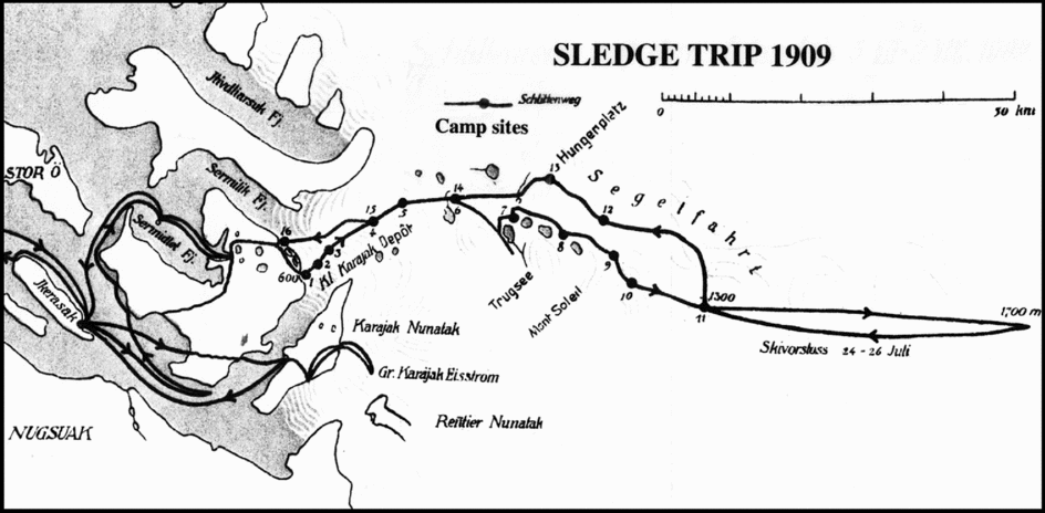
Fig. 1. Map showing details of the route of de Quervain's 1909 expedition (based on map in de Quervain and Stolberg Reference Quervain and Stolberg1911).
On 2 July they set off, using a local boat, bound for the smaller settlement of Iqerasaq. They reached it next day, and were welcomed by the bestyrer [settlement manager], Jens Fleischer, a Dane who could quote Homer in Greek, and was married to a Greenlander. That evening, travelling in two whaleboats, the party tried to reach the Qarajak Nunatak, from where they hoped to locate the route which Drygalski had used to get on to the ice cap. But this approach was foiled by the vast number of icebergs calved from the Store Qarajaq Gletscher. They then tried an alternative route, round to Sermilik Fjord on the north side of the Drygalski Halvø. Although delayed by a powerful föhn wind, they reached a suitable landing site and camp-site. From a nearby hill de Quervain had a clear view of the front of the ice cap and was able to trace a potential route across the intervening rocky foreland to the ice front.
It was now discovered that the hypsometer, used for calibrating aneroid altimeters on the basis of the reduction in the boiling point of water with increasing height, had accidentally been left behind. A Greenlander kayaker was sent back for it and de Quervain decided to stay at the camp to wait for his return. Meanwhile Bäbler and Stolberg accompanied the Greenlanders who had been hired as porters to back-pack all the equipment up onto the ice cap. Once the kayaker had returned with the instrument de Quervain also set off with a load, escorting two Greenlanders, bound for the ice cap. After 12 hours of clambering over rock ridges and making detours around small lakes they came in clear sight of the ice cap, and on it a tent.
From this point the three Swiss would be entirely on their own, hauling two loaded Nansen sledges, 2.8 and 3.8 m long. Their loads consisted of ‘a canvas tent with waterproof ground sheet with room for three (or, at a pinch, four) men, three sleeping bags, furs, cooking apparatus, astronomical and meteorological instruments, three pairs of skis, 8 ski poles, ice axes, 3 climbing ropes, 120 kg of food to last six weeks and a box of medical and surgical equipment’ (de Quervain and Stolberg Reference Quervain and Stolberg1911: 112). They set off on 9 July.
Progress on to the ice cap and then eastward across its surface was slow. Initially the major obstacles were steep-sided meltwater channels and cryoconite holes, mostly filled with water. Quite often the sledges had to be unloaded and the loads back-packed in relays. Beyond their third campsite, however, they entered a labyrinth of crevasses which delayed them drastically. At the fourth campsite they left a depot of food and fuel for use on their return trip. From the fifth campsite, however, at a height of about 1000 m, crevasses were fewer and the pace picked up. A major problem was the constant strong easterly or southeasterly winds which frequently threatened to blow the tent away.
On the basis of a noon measurement of the sun's altitude, and on the basis of two chronometers de Quervain was able to establish the position of each campsite. He considered that the accuracy of his latitudes was ± 200 m and that of his longitudes 500 to 1000 m.
After a week of progress (generally using crampons), they started to encounter snow, and switched to skis. At this point, too they encountered a series of small lakes with meltwater streams connecting them; the latter commonly represented serious obstacles. Thereafter they encountered a maze of crevasses that they commonly had to cross via dubious snow bridges.
At the 11th campsite, on 24 July, a decision had to be made. It was clear that due to their relatively slow progress a crossing of the entire ice cap was quite unrealistic, given the amount of food and fuel required. It was therefore decided that de Quervain and Bäbler would continue eastward, unladen, on skis, while Stolberg would remain in camp to take careful altitude measurements. Starting on the evening of that day de Quervain and Bäbler skied eastward into a strong wind until noon next day. At their turning point they had reached a height of 1700 m. After taking readings to determine their position and after some sleep the two men started back west, reaching the 11th campsite safely in the early hours of 26 July having covered a total distance of about 85 km.
The first part of their return route lay somewhat north of their outward route. Initially there were few crevasses and for the first two days they were able to take advantage of the steady east wind, setting sails on their sledges. But thereafter crevasses slowed progress severely as the sledges capsized repeatedly. They regained their outward route at the 14th campsite (the 6th on their outward route); this was crucial since from here one of the few safe routes led through a field of crevasses. By the end of the following day they were greatly relieved to see the Swiss flag they had left flying over the depot. From there to the ice cap edge they tried a short-cut, and later regretted it, because of the endless series of meltwater channels across which the sledges had to be man-handled and were constantly capsizing. In the early hours of 1 August they reached the edge of the ice cap and celebrated because it was the Schweizer Bundesfeier (Swiss Federation Day).
They estimated that they had travelled 250 km across the ice cap. To their surprise they found that the crevasse-zone extended for 80 km from the ice edge, indicating that the subglacial substrate influenced the ice surface much further into the ice cap than they had anticipated. It was this that had slowed their progress and had made any hopes of attempting a crossing quite out of the question.
Leaving Bäbler in a tent near the edge of the ice cap, so that he could investigate the nival fauna in the adjacent rocky terrain, Stolberg and de Quervain headed down to the sea in case kayakers had arrived. They found the depot by the shore in good condition. They pitched a tent and, delighted that the plague of mosquitoes had passed, were able to leave the tent door open.
There was one worry, however. A northwesterly wind had brought a large iceberg quite close to their campsite. Next day part of it collapsed and a large wave raced shorewards. Stolberg, who had been bathing in the sea, hurriedly emerged, while de Quervain grabbed the pack with their notebooks and chronometers from the tent. Fortunately the tide was at low ebb and a belt of seaweed further protected the tent from the surging wave.
On the second day the kayakers arrived, in pouring rain. They set off back to Iqerasaq with a note for Jens Fleischer. During the following night Fleischer himself arrived by boat. Shortly afterward another boat arrived with, by prearrangement, a party of Greenlanders who would carry everything back down from the ice cap camp. Stolberg set off with them for the ice cap but on reaching its edge, he hit a snag. The Greenlanders initially refused to cross the ice-cold meltwater stream, about 1 m deep, which bordered the ice front. To try to shame them Stolberg waded through it and climbed up the steep, slippery ice front to where their tent still stood. Still the Greenlanders refused to follow him. Finally inducements such as 50 øre each, a drink of aquavit, some cakes of chocolate and condensed milk persuaded some of the men to follow him. The women had been excused from tackling these final obstacles. The tent, equipment and remaining food were packed on the two Nansen sledges, which were then lowered down the steep ice slope with ropes. Everything was then man-handled across the meltwater stream; after camping for the night Stolberg and the Greenlanders hauled everything across the rocky foreland to the shore.
Next day, since there was not enough room in the boat for the entire party, de Quervain, accompanied by two Greenlanders decided to hike back to Iqerasaq; it was estimated that this would take them 24 hours. To de Quervain's dismay he found himself traversing rock ridges and detouring around complex branching lakes. They reached a point on the mainland opposite the settlement of Iqerasaq on its island. A smoke signal, produced by piling green branches of dwarf birch on a fire, was spotted from the settlement and a boat was quickly rowed across, and within two hours de Quervain and his companions had rejoined the rest of the party at Iqerasaq.
De Quervain still wanted to survey the margins of the Store Qarajaq Gletscher on Quarajaq Nunatak, for comparison with Drygalski's measurements. Since the Lille Qarajaq Fjord was still choked with icebergs a somewhat complicated route had to be tackled. The party consisted of de Quervain, Bäbler and Heim who had now joined the party after completing his survey of the coal outcrops on Disko and on Nuussuaq. They travelled by boat to the south shore of Drygalski Halvø. From there everything was back-packed across part of the peninsula to the camp of another Greenlander, Pavia, on Lille Qarajaq Fjord. One of the Greenlanders portaged de Quervain's kayak for him. Next morning, from Pavia's camp the party wove its way through the labyrinth of icebergs and floes in two kayak-rafts, each consisting of three kayaks. The two outer kayaks were paddled by Greenlanders while the Swiss scientists sat in the centre with their irreplaceable instruments.
Having climbed up onto the Quarajaq Nunatak de Quervain and Heim spent the rest of the day in selecting sites for surveying the glacier margin, and they also located Drygalski's hut. De Quervain had also hoped to visit Renntier Nunatak, lying to the southeast, but could not afford the time. As a compromise Bäbler, who was particularly interested in investigating the fauna and flora on the nunatak, set off toward it on his own, having promised to return within 40 hours. De Quervain and Heim spent the following day in surveying and photographing the margins of the Store Qarajaq Gletscher; they were relieved when Bäbler returned that evening.
As Bäbler was leaving he had been informed by a Greenlander that this area of the ice cap was impassable; but Bäbler, putting this down to the Greenlanders’ general fear of it ignored this warning. He would live to regret this. Crossing from the Qarajaq Nunatak to the ice cap at the same spot which Drygalski had selected, he soon found himself in a chaos of crevasses and deeply incised meltwater streams, which in places disappeared terrifyingly down moulins. After slipping and falling from a sharp-edged sérac, he fortunately found himself unhurt; he then cat-napped for 90 minutes. When half the time at his disposal had elapsed and he realised that he was only halfway to the Renntier Nunatak, he turned back. The return trip was more demanding and dangerous, especially since he was now tired. On reaching the Qarajaq Nunatak again he made himself a bed of dwarf willows and moss and slept soundly for two hours. Then he rejoined his companions; in his account of this near-suicidal trip Bäbler admitted that the Greenlanders had been right (Quervain and Stolberg Reference Quervain and Stolberg1911:157).
Next morning a boat appeared to pick them up directly from Qarajaq Nunatak since the icebergs and ice floes had now largely cleared out. By that evening they were back at Ikerasaq and next day set off in two boats for Uumannaaq. En route the boats stopped at Uumannarsiaq so that the Swiss scientists could watch a drum-dance. Generally discouraged by the missionaries, this was allegedly the only place on the west coast where it was still practiced.
On 17 August de Quervain and his companions boarded Hans Egede, and most of the population of Uumannaq waving from shore, the ship got under way, despite a belt of drift ice which had surrounded her. The ship headed around the west side of Disko and on the morning of 19 August reached Egedesminde (now Aasiaat). There the Swiss scientists met Dr. Frederick Cook, who had arrived there from Upernavik on board Godthaab earlier. Cook was homeward bound following his alleged successful attempt at reaching the North Pole (Cook 1914; Bryce Reference Bryce1997).
On 22 August, with Cook, de Quervain and his companions sailed on board Hans Egede for Copenhagen, via Godthåb. In conversation with de Quervain Cook made a remarkable comment which totally contradicted his claim of having been at the pole. He remarked that at the North Pole, the sun had been at very different heights at midnight and at noon, something that was possible only well south of the pole (de Quervain and Stolberg Reference Quervain and Stolberg1911: 169; Orth Reference Orth2013: 59). De Quervain, wishing to believe that Cook had indeed reached the pole, tried to convince him, apparently successfully, that his memory must be at fault. Since there was an international group of scientists on board, a lecture series was organised, with Cook giving a lecture on 29th on ‘his alleged attainment of the Pole. . . . One may think what one likes about Cook, but what he presented that evening to an intent audience in a vivid style about his wintering and his journey, was something to experience’ (de Quervain and Stolberg Reference Quervain and Stolberg1911: 166). Hans Egede made a brief stop at Lerwick in the Shetland Islands on 1 September, especially at Cook's request so that he could send telegrams to announce his achievement. When the ship reached Copenhagen on 4 September Crown Prince Christian, his uncle Prince Waldemar, and the American consul, Maurice Eegan, came aboard to welcome Cook (Cook Reference Cook1911; Bryce Reference Bryce1997). Thereafter de Quervain and his companions travelled home to Switzerland.
On his return to Zürich de Quervain was appointed director of the Degenried Seismological Station, under the auspices of the Meteorolisches Zentralanstalt (de Quervain, M. Reference Quervain and Quervain1998). Soon afterwards a further major event in his life was his marriage to Elizabeth Nil in 1911.
The 1912 expedition – preparations
Unless otherwise stated de Quervain (Reference Quervain1914) is the source for all the information about the 1912 expedition.
His 1909 expedition had only whetted de Quervain's appetite. While his penetration onto the ice cap had thrown some light on its physical characteristics, the need for further information on its shape and characteristics north of the line of Nansen's crossing still remained. De Quervain therefore decided to mount a second crossing. At an early stage in his planning he evidently wrote to Porsild at the Disko research station seeking his advice, and even inviting him to accompany him for at least some distance. De Quervain had clearly indicated that he hoped to first spend six weeks at Holsetinsborg (now Sisimiut) learning how to drive dogs. Porsild's reply was devastatingly negative:
You want to come to Holsteinsborg in spring, drive sledges there for 6 weeks and then travel across the Ice Cap in summer! What would your reply be to a good citizen of Copenhagen if he told you he would be travelling to Switzerland to climb Mont Blanc without a guide and, for practice, ascending the Blocksberg en route? . . . If I had any interest in the failure of your plan, honest to God, I could not think of anything more effective than to approve of this plan. . . .
First of all: Come here in the autumn so that you and your companions can learn nothing but dogs and dog-driving; you will need all your time. Secondly: choose a different season, namely April or May at the latest for the crossing. And thirdly and finally, forget about the dogs; after 6 weeks of training (!) at Holsteinsborg (!!) you will achieve nothing but anguish and unnecessary stress (Orth Reference Orth2013: 65–66).
Undaunted, de Quervain proceeded with his plans, although, with regard to the timing of the crossing, as we will see, he might have found much easier conditions had he followed Porsild's advice as to his timing (Fig. 2).
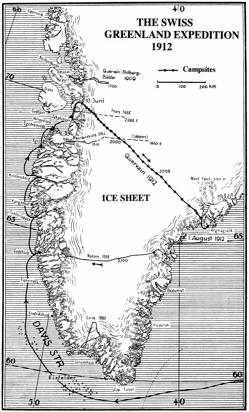
Fig. 2. Map showing routes of de Quervain's 1909 and 1912 expeditions, and of various earlier expeditions on the Greenland ice cap (based on map in de Quervain Reference Quervain1914).
With regard to the direction in which such a crossing should be attempted, the fact that arrival of the annual ship at Ammassalik (now Tasiilaq), dictated by ice conditions, was not until August or early September, meant that an east–west crossing, such as Nansen had made, must inevitably result in having to winter in Greenland (de Quervain Reference Quervain1914: 4). On the other hand, in terms of a crossing from west to east, there arose a potential problem in that Ammassalik lies on an island. In August 1911, however, by a lucky coincidence de Quervain encountered Jens Petersen, the bestyrer from Ammassalik, in Copenhagen and was able to arrange with him that a depot of provisions and four kayaks would be left in the inner part of Sermilikfjord opposite the island of Umitujarajuit, the only island indicated on the map by Gustav Holm, on the basis of his survey of 1883–1885 (Holm and GardeReference Holm and Garde1889).
The expedition was supported, both morally and financially by a range of Swiss scientific instiutions and, most importantly, by the newspaper Neue Zürcher Zeitung. Private donations were also made by a large number of individuals, while the expedition members also contributed. Despite all these contributions de Quervain and Mercanton, glaciologist and a member of the expedition's western party, did their best to clear the expedition's remaining debt by engaging in a round of lectures following their return from the expedition. The still remaining debt was covered by a special resolution of the Schweizerische Bundesversammlung [Swiss Federal Assembly].
From a number of qualified applicants Quervain selected three companions for his intended crossing. They were medical doctor Dr. Hans Hoessly of St. Moritz, architect Roderich Fick and engineer Karl Gaule of Zürich; all had climbing and expedition experience. De Quervain had previously refused applicants from Norway, Austria and France, since he wanted this to be entirely a Swiss endeavour. Fick was German by birth, but had lived in Switzerland for almost his entire life (Orth Reference Orth2013: 24).
As soon as Fick received confirmation from de Quervain in October 1911 that he would be a member of the crossing party, he set about a variety of preparations in the workshop at his parents’ house in Zürich (Orth Reference Orth2013: 201). He lit a Nansen cooker to calculate how much gasoline the party would need for the crossing. Using a spring balance he tested the load at which different fabrics ripped to ascertain the best material for the tent. Then he built kayaks after the Greenland design, the skins being of canvas waterproofed with white oil paint. Along with de Quervain and Gaule he tried out the kayaks on the Zürichsee. Gaule capsized, and Fick slipped out of his own kayak to go to his friend's rescue. Both men clung onto de Quervain's kayak and shouted for help until rescued by the owner of a nearby dock (Orth Reference Orth2013: 22)
To get to know each other they mounted a mid-winter climbing expedition to the Engadine, using Nansen sledges. In addition, Quervain decided to enlist the support of a further three men (all Swiss) to assist the crossing party in tackling the difficult western marginal area and to accompany them for some distance onto the ice cap. These were his companion from the 1909 expedition, Stolberg, Dr. P.L. Mercanton of Lausanne, Secretary of the International Glaciological Commission, and Dr. Wilhelm Jost of Bern, photographer and glaciologist. After returning to the margin of the ice cap these three would then spend the summer making a detailed study of the marginal area. Moreover Mercanton and Jost would thereafter spend the winter at Porsild's arctic research station at Godhavn to conduct aerological investigations.
Shortly before leaving Denmark, de Quervain had a disturbing conversation with Gustav Holm (de Quervain Reference Quervain1914:13). The latter revealed that his map of the Sermilikfjord area, where de Quervain was planning to reach the east coast, was based on his having seen it only from a distance, and on the information of the local Greenlanders. His final remark was ‘Do not trust the map!’
Reaching the starting point
De Quervain and his companions put to sea from Copenhagen on board Hans Egede on the morning of 2 April 1912 (Fig. 3). After a fairly rough crossing, Hans Egede passed Kap Farvel on 13 April and reached Godthåb on 16th. To get everyone in shape again de Quervain led the party in climbing Hjortetakken, and in preparation for crossing the ice cap he bought four locally produced down jackets, insulated with eider down.

Fig. 3. The 1912 crossing party on board Hans Egede, April 1912: left to right, Roderich Fick, Karl Gaule, Alfred de Quervain and Hans Hoessly (ETH-Bibliothek Zürich, Image Archive).
On 19 April Hans Egede continued north to Sukkertoppen (now Maniitsoq). As she was to remain here for several days, de Quervain took the opportunity to mount a minor expedition to nearby Sermilikfjord. Reaching the head of the fjord by motor boat the party pitched their tent there on 21st, climbed a nearby mountain on skis, and laid out a short survey baseline on the summit. Next day they visited a nearby glacier and later that evening were picked up again by the motor boat and returned to Sukkertoppen.
On 23rd Hans Egede headed north to Holsteinsborg where de Quervain and his companions left the ship the next day. They first gave a little demonstration of their kayaking skills (Orth Reference Orth2013: 36). By pre-arrangement they were to stay at the doctor's house. By the evening, with the help of some of the local people, they had transported most of their supplies and equipment to the house, which lay some distance from the shore.
The members of the western group (Mercanton, Stolberg and Jost) were to stay in Holsteinsborg for the next few weeks, checking that all the instruments were working, taking meteorological observations and carrying out pilot balloon and kite and captive balloon ascents. De Quervain had arranged that he and his companions underwent an intense period of learning how to drive dogs, although for a much shorter period than the six months which Porsild had recommended. Their instructor was David Ohlsen who lived at Sarfanguak, about 40 km up the fjord from the settlement. De Quervain and his companions travelled there in the motor boat of the local doctor, Dr. Petersen, who was conveniently making his regular visit to Sarfanguak. In the meantime a group of Holsteinsborg women were hired to make kamiks for the porters whom de Quervain would later employ, from sealskins that he had bought at Sukkertoppen. And before leaving for Sarfanguak, de Quervain also had a number of dog-whips made. Their first attempts at wielding the whips were both embarrassing and painful, since they frequently wrapped the lash around their own heads instead of the intended target. Fick admitted: ‘I believe that in total during my period of practicing I received just as many welts as I later inflicted on the dogs’ (Orth Reference Orth2013: 37).
The snow had largely disappeared at Sarfanguak and hence, again taking advantage of the doctor's motor boat, the party, along with sledges, dogs, camping gear, David Ohlsen and his assistant Setti Kleist, moved to the head of Sarkardlitfjord, where there was snow, and where they camped for ten days. Fick was truly impressed by the beauty of his surroundings and would have liked to sit down and paint the scene; de Quervain, however, ordered that he should take photos. Later Fick commented on this with some irritation: ‘He sees only geological strata and such-like things’ (Orth Reference Orth2013: 38)
The first lessons in dog-driving were in the use of the dog whip, followed by repairing harnesses. Then came the finer points of dog-driving, turning right and left, stopping, standing still, faster and slower. This section of their training ended with each man driving a team for 30 km on his own. The next skill they learned was that of descending a steep slope whereby the dogs were hitched behind the sledge, so that they could brake the sledge's descent. They even tried setting a sail on a sledge, in order to take advantage of a favourable wind (Fig. 4). Ohlsen also demonstrated some of the finer points of handling a kayak, including that of performing the ‘Eskimo-roll’, that is how to right an overturned kayak by skillful use of the paddle. By 9 May David Ohlsen decided that they were more or less competent as sledge-drivers and the group returned to Sarfanguak. There, however, he unexpectedly insisted that his wife Ania and their daughters teach the Swiss scientists how to repair their kamiks. Ohlsen was convinced that ignorance of this skill had led to the death of Ludwig Mylius-Erichsen in northern Greenland in November 1907 (Amdrup Reference Amdrup1913). Ania Ohlsen and her daughters derived great amusement from the scientists’ efforts.
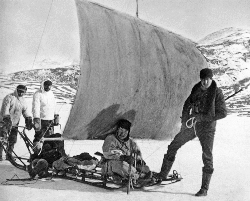
Fig. 4. Practising using a sail on a sledge; Gaule seated; Fick standing at right (ETH-Bibliothek Zürich, Image Archive, Dia_297-0034).
On their return to Holsteinsborg, by rowboat, they found that the members of the western group had been kept busy. Apart from the meterological and aerological observations Jost had been engaged in colour photography, while Hoessly had been in great demand for his medical skills especially when a serious epidemic of influenza broke out. Gaule meanwhile had been practicing the astronomical observations for determining time, since this would be essential during the crossing.
Back in Holsteinsborg the expedition members enjoyed a lively social life. Once they invited the officers from the ships Fox and Thorvaldsen, which were both in harbour, to dinner. On another occasion the Ohlsens, who were visiting Holsteinsborg, were their guests of honour. On both occasions the dinner was followed by an energetic dance that lasted till the early hours of the morning. De Quervain was not greatly impressed: ‘Although I am writing in an adjoining room, my pen is shaking as if during a constant earthquake’ (Orth Reference Orth2013: 40). In return the Swiss were invited to dinner at different times, by Pastor Friedrichsen, bestyrer Thron, and by the officers of Fox to a Whit celebration in a tent on shore.
On 1 June the expedition members left Holsteinsborg, north-bound, on board Fox. This was the same ship dispatched by Lady Franklin, under the command of Captain Francis Leopold McClintock in 1857 to search for her missing husband, Sir John Franklin and his companions; during that expedition McClintock discovered the only document ever found which threw some light on the ultimate fate of the surviving 126 men of that expedition (McClintock Reference McClintock1859). Now, under the command of Captain Stocklund, she served the coastal settlements of west Greenland. De Quervain and his companions were quite touched to see that Stocklund flew a Swiss flag (which he had sewed himself) at the masthead as long as they were on board. During a brief stop at Attu the Swiss scientists observed the midnight sun for the first time. With de Quervain acting as interpreter, Hoessly treated a number of sick residents of Attu.
Fox reached Egedesminde on 4 June. Here de Quervain was able to purchase an excellent team of nine dogs (including a powerful lead-dog named Mons) from the trading assistant, Ollrich, as well as some dog food (Orth Reference Orth2013: 41); the dogs were housed in an enclosure specially built on the forward deck. The next port-of-call was Akullit, a small settlement on Sydostbugten, where, by pre-arrangement Quervain was to purchase another team. To his dismay they turned out to be small, scrawny, yellow mutts, in striking contrast to the handsome team from Egedesminde. But since there was no guarantee of acquiring more dogs at Jakobshavn, the only other settlement at which Fox would be calling before reaching the starting point of the crossing, he bought the animals anyhow.
On the evening of Fox's arrival at Jakobshavn a meeting was held to finalise where the expedition should be landed; present were bestyrer Ohlsen, Pastor Osterman, trading assistant Krogh, and the six Swiss scientists. In 1886 Peary had started his trip from the head of Pakitsokfjord, just north of Jakobshavn, but now it was revealed that a shallow threshold at the mouth of that fjord would have prevented Fox from entering it. But through the good offices of bestyrer Ohlsen two kayakers had been sent to investigate the head of Ataasund, slightly further north, with a view to determining whether there was a feasible route onto the ice cap from there; these men had not yet returned. Nonetheless it was decided that Fox should proceed to Ataasund, with a view to probably intercepting the kayakers.
But in the meantime de Quervain was also hiring porters to assist the Swiss scientists in back-packing all their equipment and provisions across the rocky foreland to the edge of the ice cap. This was no easy task since the Greenlanders saw this as ‘women's work’ unlike such honorable ‘men's work’ as paddling a kayak or hunting. Moreover the annual run of angmasetten (capelin) was expected imminently and the Greenlanders were reluctant to miss this opportunity of obtaining an abundant supply of dogfood. Nonetheless, through the good offices of Osterman, de Quervain was able to hire sufficient porters, although possibly not the best or most reliable men.
De Quervain was also able to consult the trading assistant, Krogh, on the matter of dogs; he found the animals de Quervain had acquired at Akullit distinctly amusing. However he generously agreed to exchange them for good sledge dogs and to sell a further five excellent animals. The expedition thus ended with 29 good dogs.
De Quervain was also delighted to find that bestyrer Ohlsen had developed a small functional observatory where he had accurately established its longitude on the basis of many years of observation of star eclipses. This was of critical importance as providing a baseline for de Quervain's determinations of longitude during the crossing.
Then, with only the Swiss scientists and the Greenlander porters plus Osterman on board, Fox put to sea again on 10 June. Soon afterwards she encountered the kayakers who had been sent to reconnoitre the head of Ataasund; they reported that from a small bay, Natdluarsuk, next to the snout of the outlet glacier Ekip Sermia, a bay which Captain Stocklund later named Quervainshavn (Fig. 5), even painting the name in red paint on the coastal rocks, there appeared to be a relatively easy route across the rocky foreland to the edge of the ice cap. One of the men, Vitus, volunteered to join the expedition, to act as spokesman for the other porters and even to come some distance onto the ice cap. In the meantime he acted as ship's pilot.

Fig. 5. The steamer Fox in Quervainshavn with the front of the Ermik Sermia outlet glacier behind (ETH-Bibliothek Zürich, Image Archive, Dia_297-0044).
After a brief stop at the small settlement of Ataa on Arveprinsen Ejland, Fox steamed cautiously into Quervainshavn.
After rowing ashore de Quervain, Jost and two Greenlanders reconnoitred the route from the shore across the rocky foreland to the ice cap. They determined that the distance was about 6 km and the gain in height about 600 m. A lake about 2 km long necessitated a detour, and thereafter several rock ridges with small lakes and streams between, had to be negotiated. The edge of the ice cap was bordered by a morainic ridge about 50 m high. To gain some impression of conditions the Swiss scientists continued for about 1 km up onto the ice. They found that the snow had completely disappeared and while there were both meltwater channels and cryoconite holes neither presented serious obstacles. A pole with a Swiss flag was set up at the edge of the ice cap to guide the load-carrying porters who would follow.
On the morning of 10 June unloading began. The 29 dogs were put ashore first; they would be used for hauling half-laden sledges across the heath vegetation on the lower slopes. Once everything had been unloaded Fox proceeded to Godhavn (Qeqertarsuaq) but hit a rock as she approached that settlement. Towed close to shore, she finally sank, the hulk remaining visible for many years. The western party of de Quervain's expedition erected a monument to the ship at Quervainshavn, consisting of a large hydrogen bottle.
With Hoessly in overall charge, two days were spent in hauling all the provisions and equipment up to the ice cap, despite the reluctance of the Greenlanders to engage in such ‘dishonorable’ work. Distribution of a range of small gifts in addition to the already generous wages, tipped the balance. Everything was first hauled to an intermediate depot at the large lake, and then up the rest of the route to the ice cap. After three days of hard work on 15 June everything was stashed at a depot at the edge of the ice cap. To counter mosquitoes the men applied a repellent called Begolin, a tar-like ointment which, while effective, left their faces blackened for weeks thereafter (Orth Reference Orth2013: 68). All three of de Quervain's companions had suffered some minor injuries: while helping to unload from Fox, Fick had fallen into the hold and bruised a hip; Gaule was wearing a dressing on his forehead where a minor wound had become infected; and while climbing to the ice cap Hoessly had accidentally cut his leg with his ice-axe (Orth Reference Orth2013:67).
On the last day of back-packing the dogs were also brought up from the shore. Fick wanted to make one final quick trip back down to the shore to fetch a tarpaulin that could, if necessary be used to make a boat when they reached the coast. De Quervain angrily refused his request, insisting that they would find the depot that he had arranged to be cached (Orth Reference Orth2013: 48). To let de Quervain know what the party thought of him, on his birthday (15 June), Gaule led him into the tent, carrying, as symbols of de Quervain's position an ice axe and a dog-whip. When de Quervain enquired as to the significance of the whip he was told, gently, that he was a hard commander, and his tyrannical style was very much out-of-date (Orth Reference Orth2013: 68)
These were only some of the earliest signs of interpersonal frictions on the expedition, a feature common to many polar expeditions, especially between de Quervain and the others, particularly Fick. Some time later the latter noted:
Clearly on the Ice Cap he still esteemed me not very highly. He also behaved towards me extremely rudely, and the result is that for a long time I had only the most essential dealings with him. I no longer had any conversation with him, morning or evening in the tent (Orth Reference Orth2013: 235).
Later Orth found an entry in de Quervain's journal which reveals that it did not take much to irritate him. With the help of his parents Orth deciphered the somewhat difficult handwriting of this entry, dated 9 July, at campsite 17 as: ‘Fick's endlessly playing symphonies on his flute gets on my nerves’ (Orth Reference Orth2013: 235).
Back at Quervainshavn, a kayaker was sent off with the last mail to Ataa. He returned three days later to report that Hans Egede, which had been expected, had still not arrived. In the meantime the crossing party had been kept busy packing their sledges. They would be using a dark-coloured tent measuring 2 by 2.4 m with a useful embayment at the back, with a sewn-in groundsheet and with two bamboo poles of 3 cm diameter. Sleeping bags were of reindeer skin, and the skis were made of ash. Cooking was done on a primus stove; they took 30 litres of kerosene but only about 12 litres were used on the crossing. Pemmican (373 kg) formed the bulk of the provisions for both men and dogs. Other major food items included Maggi soups, dried vegetables, jam, canned meat, condensed milk, honey, butter, cheese, apple slices and extremely hard rye bread. Hoessly was in charge of the distribution of the daily rations.
The 29 dogs were divided into three teams, the hitch used being the fan hitch to which the dogs were accustomed. At each campsite they were tied at right angles to the sledges. They were fed once per day as soon as the party had stopped for the night. Chunks of pemmican were thrown to each team, distributed as fairly as possible to each animal. All the pemmican would disappear in a few seconds, and usually this would be followed by a brawl as animals which were slow in eating their share were attacked by others. The general free-for-all would have to be broken up by the men, wielding their whips (Orth Reference Orth2013: 144).
The crossing
The three sledges set off at noon on 20 June, and for the first day the four men of the crossing group were accompanied and assisted by the western group of Stolberg, Mercanton and Jost plus five Greenlanders; Stolberg and three Greenlanders then turned back. Mercanton, Jost and two Greenlanders then joined the crossing party in their tent for the night, a rather tight squeeze for eight men. Next day they entered a crevasse zone; occasionally a dog would fall down a crevasse, but invariably was hauled out, unharmed, saved by its harness.
Later next day, having detoured around some slush lakes, taking advantage of the assistance of Mercanton, Jost and the two Greenlanders, the party camped for the night at a height of about 1000 m. Next day the support group started back west while the three sledges of the crossing party continued eastwards (Fig. 6). The plan had been for this support party to accompany the crossing party for a full week, but the Greenlanders insisted on turning back on the third day; Mercanton and Jost went with them to ensure that the Greenlanders got back to the edge of the ice cap safely (Orth Reference Orth2013: 69). Initially the crossing party was travelling on snow-free ice, but then they reached a continuous snow-cover. This was deceptive, however; beneath the surface snow layer was a layer of slush on top of the ice, and from time to time the surface layer would not bear a man's weight and one would break through into the slush layer beneath. On skis, however, this problem was solved.
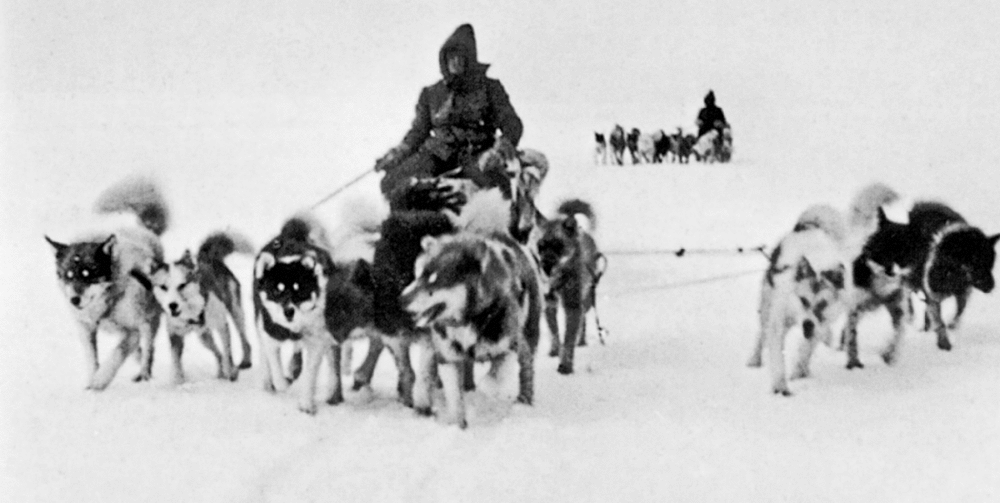
Fig. 6. Two of the three dog teams on the move on the ice cap (ETH-Bibliothek Zürich, Image Archive, Dia 297_0066).
When the party had been on the move for about three hours next morning (23 June) Hoessly, who was driving the lead sledge failed to notice that he had started across the snow-covered ice of a lake. Fick thought the ice looked thin, and wanted to hold back, but both his team and the third one raced after Hoessly's dogs (Orth Reference Orth2013: 78). Hoessly managed to reach a zone of stronger ice safely, but the other teams following close behind were not so lucky. The ice broke beneath both the second sledge (Fick’s) and the third sledge (Gaule's and de Quervain’s). Gaule and Fick quickly managed to haul themselves out onto floes (Orth Reference Orth2013: 12). Plunged into icy water de Quervain was unable to touch bottom, but the sledge was partly on stronger ice. Fick stretched out a hand to help de Quervain, but he refused this help and with the support of the sledge he managed to crawl out onto stronger ice, before the sledge broke through even more.
Despite repeatedly breaking through and floundering about in icy water until they managed to clamber out, Fick, de Quervain and Gaule managed to cut their dogs loose. Then, despite freezing hands and clothes that had frozen into an icy armour they managed to cut the lashings on the sledges and to retrieve essential items such as the sleeping bags (in water-proof bags) and the cook-box. They were then able to haul out the lightened sledges. This, however, involved about three hours of excruciating work while partly submerged in ice-cold water. While cutting the lashings Fick accidentally cut several of his numb fingers, and they were bleeding quite badly (Orth Reference Orth2013: 13, 94). Fortunately almost all the instruments had escaped undamaged although a stereoscopic camera was wrecked. Also the wood of the theodolite case was so badly swollen that de Quervain was unable to open it for several days. Boxes of bread, biscuit and rusks had absorbed a lot of water, and quickly froze solid. One item that sank to the bottom of the lake was a bag of capelin, intended as dog-food. Remarkably almost all the other equipment and provisions were saved, although the dogs took the opportunity to eat almost all their harnesses and traces. Very importantly the waterproof containers of matches, distributed among the three sledges, were all recovered.
Once the tent was pitched the men crawled into their sleeping bags and began warming up to some degree; once they had something hot to eat and drink, they suffered no long-term ill effects. It is clear, however, that they had been extremely lucky. They might easily have had to abandon the expedition, and had they lost the sleeping bags and/or the tent and had the weather deteriorated, they might well have suffered serious injury due to frost-bite.
De Quervain had quite often been ski-ing ahead, as fore-runner, but from now on he made a point of constantly travelling about half a kilometre ahead in order to spot any more frozen lakes in time to avoid them. On 25th, the day after the lake-incident, they camped for the night after covering 17.5 km, this, however, also involved an ascent of about 100 m. This was almost exactly, as it turned out, where their route intersected Peary’s. In general they were hoping to cover at least 15 km per day.
On the eighth day of travel they passed the last of the frozen lakes. They were now on a featureless plain and made good progress, covering 21.5 km. On 29 June (campsite 10) de Quervain noted in his journal that, rather worryingly, they had passed through an area of major crevasses up to 35 m wide, but generally covered by snow bridges. This was evidently the catchment area of the Jakobshavn Isbræ, indicating that the ice-stream feeding into that glacier was influencing the ice movement as far as this into the interior. As far as possible they would try to cross the crevasses at right angles. Quite often the dogs and even the sledge would cross a snow bridge safely but the driver often broke through. Fick reported that he would often break through up to 20 times per day, but, hanging onto the steering bow of the sledge, would be pulled out as the dogs raced onwards (Orth Reference Orth2013: 127).
The men soon learned that travelling with dogs had some negative aspects, familiar to many polar explorers. In the fan hitch, the dogs would constantly change places, so that the traces were soon twisted into a thick plait. Since the dogs frequently defecated while on the move this plait was often smeared with faeces, which made the task of untangling the traces unpleasant, quite apart from one's fingers being almost numb with cold. Any minor wounds in one's fingers tended to become infected and were slow to heal. Whenever they got the chance, too, the dogs would eat their traces and harnesses. To prevent this they were muzzled after they had been fed (Orth Reference Orth2013: 128).
When the men themselves had to defecate, the dogs often posed a hazard: any loose dogs would invariably come running, and gobble up the excreta as soon as it appeared. The men would try to fend them off with ski-sticks or with a whip, afraid of being bitten on the backside (Orth Reference Orth2013: 138).
The four men took turns at being fore-runner. On 29 June Gaule was the fore-runner for the first time, in thick fog and drifting snow. He soon started to veer left of the intended course, and, from the perspective of the sledge drivers following him, he disappeared in the fog and snowdrift. With the wind that was blowing he could not hear their shouts. Worst of all was the fact that ski tracks were almost immediately drifted over. The only thing the sledge drivers could do was to follow him, as fast as the dogs could run. Finally Gaule heard their shouts and stopped (Orth Reference Orth2013: 136). They might easily have lost him completely.
On 3 July, at campsite 13 de Quervain reported that they had covered 25 km that day and had reached a height of 2100 m. This campsite fell almost exactly at the intersection with the alleged route of Nordenskiöld's Lapps. However a comparison with their reported height with that of the Swiss party would indicate that the Lapps had covered a much shorter distance than they had reported.
In overcast, foggy weather such as they experienced on 6 July the fore-runner's job was difficult since he had no point of reference at which to aim. De Quervain's solution was to take compass bearings from the lead sledge and then signal to the fore-runner with a small flag to turn more to the right or left as the situation demanded.
On 7 July, since a blizzard was blowing, it was decided to enjoy a rest-day. The men brought their journals up-to-date, read from the party's severely limited library, and slept. Meanwhile sledges and dogs became totally drifted over. On going outside next morning Fick found that the snow was packed so hard that his nailed boots left no marks. There was no sign of sledges or dogs, except for a few small holes in the snow, kept open by the dogs’ breath. When the sledges and dogs were dug out from the wind-packed snow one dog was found dead (Orth Reference Orth2013: 148). Again the dogs had taken the opportunity to eat all their harnesses and traces. Hoessly, who had somehow become the expert, set to work to make new harnesses. On 18th day of the trip the wind had largely died and it was practically calm by the afternoon; on that day they covered 32 km and had reached the half-way point of the crossing, although they were still climbing.
Two days later one of the dogs, which had injured a leg and was unable to pull, was reluctantly shot. The carcass was dressed and the meat cut up and later fed to the other dogs. They ate it quite greedily. The men also included some of the meat in their soup ‘and it tasted not bad at all’ (Orth Reference Orth2013: 150).
On 12 July there was another wicked blizzard with heavy drifting snow but the party pushed on despite this, for a distance of 20 km. The fore-runner up ahead would commonly disappear from sight; each man had icicles hanging from his chin and at the end of the day it took de Quervain half an hour to remove his hood since beard and hood were a solid block of ice.
At each campsite a range of scientific observations was made, usually before leaving the campsite. Using a theodolite Fick would measure the gradients in each direction. Using a bamboo sounding pole he would measure the snow depth down to the ice. Gaule meanwhile calculated the compass variation. Next, if the sun were visible he would take sightings on it in order to determine the latitude; in this de Quervain sometimes assisted. The longitude was determined by using chronometers. Distances covered were determined by a measuring wheel towed behind one of the sledges. Regular weather observations were made by de Quervain (Fig. 7). And finally, usually once camp was pitched, de Quervain would determine the altitude using a hypsometer. This gave a more accurate determination than that of the aneroid barometer which he also checked (Orth Reference Orth2013: 160–161).
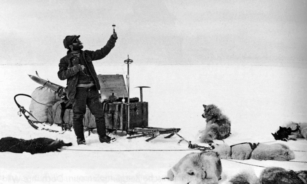
Fig. 7. De Quervain checking wind velocity with a hand-held anemometer (ETH-Zürich, Image Archive, Dia_297-0071).
On the morning of 13 July Fick's readings indicated that they had passed the highest point of the ice cap, having covered about two thirds of the total length of the crossing, much further east than had been expected (Orth Reference Orth2013). To celebrate the Swiss flag and the Bern flag were hoisted on the long sounding pole. Finally, on the evening of 17 July, early on 25th day of travelling, Fick spotted the first land on the east side of the ice cap, a high mountain on the horizon to the left of their course; it was named Mont Forel, the second highest mountain in Greenland, at 3383 m. They covered 42 km that day and 45 km the following day, the dogs trotting and even galloping. Since the temperature was now rising slightly above freezing during the day, they had reverted to travelling at night. And there was indeed a ‘night’ since the sun had started to dip briefly below the northern horizon (Orth Reference Orth2013: 181).
By the early hours of 19 July an unbroken wall of mountains stretched to their left, it was assumed they lay beyond Sermilik Fjord. Then some peaks appeared straight ahead; they assumed these were on Ammassalik Ø. But there was still little sign of their altitude decreasing; they were still at 1300 m. Soon a system of branching fiords came in sight but they were totally unable to match them with the Holm map. But then the surface did start to drop and de Quervain had a bad scare. He had got a little ahead of the sledges, skiing down a slope of hard firn where his skis barely left a mark. The other three, following with the sledges saw that the gradient looked too steep and dangerous, and therefore detoured somewhat to the left. De Quervain was already out of shouting distance, and they hoped that he would spot them when he realised that they were not following him (Orth Reference Orth2013: 191). With the slope steepening, de Quervain found himself among a labyrinth of crevasses with unsafe snow bridges. Stopping, he turned to wave to warn the sledge drivers to take a different route. But to his horror there was no sign of the sledges. For a moment he contemplated the possibility that they had all disappeared down crevasses, but rejected the idea as being highly improbable. Skiing back up the slope, after almost an hour he found some sledge tracks and started following them. After almost a further hour he spotted all three sledges. He clearly was chastened by this experience. To quote Fick the sledge drivers ‘were expecting a tirade of abuse, but de Quervain uttered barely a word, he was so relieved’ (Orth Reference Orth2013: 192).
Searching for the depot
That night they camped on the moraine at the edge of the ice cap. On climbing to the top of the morainic ridge de Quervain and his companions were faced with a sight that had them completely baffled. They expected to see below them the smooth coastline of Sermilikfjord with the large island of Kekertatsuatsiaq and the small islet of Umitujarajuit, as indicated on Holm's map. Instead three major parallel rock ridges extended south for about 15–20 km, separated by narrow fjords with numerous islands. Clearly the map was seriously inaccurate.
It was decided that de Quervain and Gaule would head south along the westernmost of the ridges (Gauleberg, now Gaule Bjerg) for two to three days to look for the depot. Hoessly and Fick would meanwhile remain at the last camp (campsite 29); while waiting they would design a boat with available materials, kill many of the dogs and cache their meat securely, and carry out meteorological and other observations. If de Quervain and Gaule were not back within six days they were to try to reach Ammassalik on their own.
De Quervain and Gaule set off at 3.30 a.m. on 22 July with provisions for five days. Initially on snow, then, having left their skis, on a rocky ridge, they reached the end of the peninsula that evening; from here, to the south, they could see a large island which they assumed correctly was Kekertatsuatsiaq. But if so, where was Umitujarajuit and the depot? They guessed that they lay off the east side of the easternmost of the three peninsulas, which they named Hoesslyberg (now Hoessly Bjerg).
Through binoculars they spotted what looked like a feasible route down from campsite 29 to the head of the fjord between Gauleberg and Fickberg (now Fick Bjerg). It should be relatively easy to paddle there by kayak from where they thought Umitujarajuit and the depot must lie. Acting on this assumption the two men started back north along the east side of Gauleberg, having first descended to sea-level. Here they encountered patches of crowberry (Empetrum nigrum) and using this as fuel they lit a large, smoky signal fire in case Petersen had sent a party to watch for them. Warmed by the fire, they slept for three hours, heated some pemmican porridge and melted some snow. They then continued north along the eastern slopes of Gauleberg to the head of the fjord, up and over Fickberg, down to the head of the next fjord and up and over Hoesslyberg. At 4 p.m. on the third day they spotted below them a small island that had to be Umitujarajuit and near the shore, opposite this island, a large cairn. A willow branch projected from the cairn, pointing to the northeast. Climbing down to the shore in that direction they found another cairn with a Danish flag flying above it. In the depot they found a note from Petersen: ‘Welcome; the kayaks are lying on the shore down below and kamiks are lying in them.’ Also near the kayaks lay some wooden cases including, among other things 25 kg of pemmican, 5 kg of chocolate, six jars of cherry jam, 6 jars of greengage jam, a can of Maggi soup and five cubes of Maggi soup, bars of soap and replacement sun glasses (Orth Reference Orth2013: 218). Having pitched the tent that they also found in the depot they cooked and ate a large meal, then went to sleep.
They stayed at the depot for about 48 hours, during most of which time they maintained a smoky fire on the rocks above the depot in case any Inuit were anywhere in the vicinity. But when there was no response they decided to head back to alert their companions that all was well. There were four kayaks and they set off, paddling two and towing two. A strong south wind caused considerable difficulties since the towed kayaks tended to be blown sideways. Then, when they reached the narrows at the mouth of the fjord between Gauleberg and Fickberg, which they named Hoffnungfjord (later renamed Hundefjord in honour of their dogs), the strong outflowing ebb tide brought them to a halt despite their best efforts and they were forced to land on a small island and wait for the rising tide.
Reaching the head of the fjord they cached the kayaks securely and started up the long slope to where they had left their companions. But there was no sign of them at the old campsite, just a lot of blood stains where they had killed the dogs, and a sledge box. In it a note revealed that Fick and Hoessly had moved camp to a more sheltered site in the lee of the moraine.
It was five days since de Quervain and Gaule had departed and their companions had started to get anxious. As instructed by de Quervain they had designed a boat using the tent and sledge sails, and wood from the sledges and skis. The only reasonably large piece of fabric was that of the tent, but it was far from waterproof, and they had nothing with which to waterproof it. This led them to contemplate two unattractive scenarios; building a boat with the tent fabric, which they would have to bail constantly, and land periodically on floes or on shore to empty the boat, or else wait until the sea froze and continue with the sledges, which would not occur until November or even December, although they had food and kerosene for only two months (Orth Reference Orth2013: 201). They had also slaughtered most of the dogs except for about a dozen which they hoped to take home on the ship, or else to leave them on an uninhabited island. The unpleasant task of shooting the dogs fell to Fick. He found the task absolutely abhorrent; in view of this, he spread the job over several days. More than once the dog was not killed with the first shot, which made the task even more repugnant. If not restrained the remaining dogs would pounce on the carcass and devour it. But if possible the two men would cut up the carcasses, stowing the meat under rocks, and spreading the skins under their groundsheet to make the tent site a little softer (Orth Reference Orth2013: 207).
Having first built a cairn on a rock by the moraine, at noon on 28 July the reunited party started down the slope to the kayaks at the head of the fjord; each man made several trips but a long snow slope made the descent quite fast and easy. Having loaded as much equipment and provisions into the kayaks as possible, and having cached the remainder, they set off down the fjord at 6 p.m. on 29 July. The four kayaks were lashed together into a kayak-raft, but even so the load was so great that the kayak decks were almost awash (Orth Reference Orth2013: 224). The surviving dogs had accompanied them down to the shore, and were left there; Hoessly shot one of them, to provide the rest with at least a minimum of food. They timed their departure to get the benefit of the ebb tide in the narrows. A beam wind caused some problems, and progress was further slowed by the fact that Hoessly had injured an arm and his kayak had to be towed. Around midnight they emerged into Sermilikfjord and started working their way through a labyrinth of icebergs. After nine hours of paddling they reached the depot. They were barely able to stand when they crawled ashore at the depot, especially Gaule, whose kayak had sprung a leak and who was badly chilled. He had been staying afloat by sucking up the water with a rubber tube and spitting it over the side (Orth Reference Orth2013: 225). Pitching a tent, they spent the next two days resting and eating, although taking the precaution of lighting and tending a signal fire. It, however, did little to deter the swarms of mosquitoes.
By kayak and umiak to Ammassalik
At noon on 31 July, when the party had retired to the tent because of the mosquitoes they suddenly heard voices. Rushing out, they spotted three kayakers approaching. The three men, Timotheus, Ferdinand and a man whose name they could not catch, were from a summer camp about 40 km to the south near the entrance to Sermilikfjord.
Since Gaule was suffering from a serious infection it was decided that Hoessly and Fick would stay with him while de Quervain, accompanied by two of the Inuit, paddled to Ammassalik. The three kayaks set off at 6 a.m. on 1 August. Initially the two Inuit moderated their pace to match de Quervain’s, but then, at their suggestion they lashed the three kayaks together; one of them towed from ahead, while the other snubbed the bow of his kayak to the stern of de Quervain’s. Then they proceeded at twice their former speed. De Quervain even fell asleep, leaving the Inuit to do all the work.
By 5 p.m. they reached the Inuit camp near the mouth of Sermilikfjord. At a second camp nearby an old man, Kitsigajaq, made his umiak available, and with a group of women rowing, and de Quervain taking his ease, it immediately put to sea. Shortly afterwards the church and the three wooden houses of Ammassalik came into view, and at Kitsigajaq's suggestion, de Quervain fired a few shots and started waving his Swiss flag. He was warmly welcomed by Jens Petersen, the bestyrer, who insisted that they stay in his house. The date was 1 August, the Swiss National Day.
Next day two umiaks, one of them steered by Ferdinand set off for Sermilikfjord. From the Inuit camp there Hoessly then set off with one of the umiaks back to the head of Hunedefjord to retrieve the provisions etc. which had been cached there, and to shoot all but five of the dogs. This accomplished, both umiaks started back for Ammassalik and during the night of 4–5 August they reached the settlement. At Petersen's insistence the five dogs that de Quervain hoped to be able to take home to Switzerland, were landed on a nearby small island.
That night de Quervain started hallucinating, seeing whales emerging from the picture frames (Orth Reference Orth2013: 239). He therefore pitched a tent outside, but still in the settlement and, afraid of polar bears insisted on taking a rifle and ammunition with him before settling down there on the following night. Anxious that he might start shooting at imaginary whales in the settlement, his companions became very anxious and contemplated taking the extreme precaution of locking him up (Orth Reference Orth2013: 240). But when de Quervain saw imaginary animals in the tent, too, he moved back into the house. In his own account he simply remarks, concerning this whole peculiar affair that ‘later, for many nights I could not stand sleeping in a house’ (de Quervain Reference Quervain1914: 120).
On the following day about 20 kayaks and five umiaks arrived from outlying camps to trade at the store and to attend the church where several baptisms and a marriage took place. During the next few weeks the Swiss scientists became well acquainted with the local people. But finally, on the morning of 28 August, the steamer Godthaab arrived. De Quervain hoisted the Swiss flag, then raced down to the shore and paddled out in his kayak since he expected his wife to be on board, as indeed she was. On 3 September Godthaab got under way again bound for Copenhagen via Reykjavik. On board were the four Swiss, but to their great disappointment none of the dogs, since the authorities in Copenhagen had strictly forbidden the captain to take them on board.
On reaching Reykjavik on 8 September de Quervain sent a telegram to Bern to report the expedition's successful crossing of the ice cap; in return he received a welcoming telegram from the Schweizerische Naturforschende Gesellschaft. Two weeks later the Swiss party continued their journey to Copenhagen on board the steamer Sterling, arriving on the morning of 29 September. Since it was early in the morning they were surprised to see a lady waving a Swiss flag on the dock, this was Mme. Mercanton, and next to her stood her husband. De Quervain caused some confusion, and subsequently suffered some embarrassment when he fired his signal pistol in reply.
The Swiss party was welcomed by a delegation from the Royal Danish Geographical Society which invited them to a reception and dinner at which they met Jens Jensen, Gustav Holm, Thomas Garde and Graf C. Moltke; the latter two had made an extensive journey on the southern part of the ice cap in 1893 (Garde Reference Garde1896). They even met Ejnar Mikkelsen, who had only just returned from the severe hardships of his expedition to northeast Greenland in search of Ludvig Mylius-Erichsen and his companions (Mikkelsen Reference Mikkelsen1913). De Quervain was also invited by King Frederick to a private audience at which the latter proposed that he be awarded the Order of Dannebrog. As a federal official, de Quervain was obliged by a clause in the Swiss constitution to decline this honour.
The most important end-result of this crossing of the ice cap was a detailed profile of the ice cap some 640 km in length considerably further north than Nansen's crossing, and significantly longer than the latter (roughly 375 km). De Quervain and his companions completed their crossing in 30 days, against the 41 days that Nansen had taken for his crossing. De Quervain's survey revealed that at this latitude the ice cap occupied the entire interior of Greenland, and probably did so right to its most northerly extremity. The accuracy of the positions of the campsites on which the profile was based, was ± 0.1 minutes in terms of latitude and ± 2–3 seconds in terms of longitude. The regular temperature measurements revealed a striking contrast between the relatively small daily fluctuations in the marginal areas and the much larger fluctuations over the higher areas of the ice cap. The lowest air temperature recorded, at 2.35 a.m. on 11 July, was –21.4° C; the maximum at 2 p.m. on that date was –8.4°. By contrast, on 22 June, the third day of the crossing, the air temperature ranged from +0.2° at 8.15 a.m. to –1.3° at 9 p.m.
The western group
On the morning of 22 June the western group of Mercanton, Jost and Stolberg, along with Greenlanders Jens and Emil, said goodbye to the crossing party some 20 km from the western edge of the ice cap at a height of about 1000 m. They were back at the edge of the ice cap that same evening. Having selected a site on the bare ground some 800 m from the ice cap edge, relatively sheltered from the persistent southeasterly wind, they pitched two tents: a silk tent for themselves and the other to act as a store and also to accommodate their anticipated Greenlander visitors. Unlike the crossing party that enjoyed excellent reindeer-skin sleeping bags, the western group for some reason had been allocated waterproof bags with a flannel lining and with inflatable pillows, which were an endless source of irritation.
The group was abundantly supplied with provisions: rye bread, pemmican, milk, honey, butter, chocolate, fruit and canned vegetables. By mistake the crossing group had taken all the prickers for the Primus stove, an accident which might have had serious consequences, but fortunately they found a discarded one at the last campsite and also a piece of steel wire in Mercanton's luggage.
They made fairly frequent trips down to the depot at the shore in Quervainshavn, where extra provisions, instruments, clothes and a kayak had been cached. Here, too, was the expedition's wooden boat, Ella, which was the source of endless problems. To protect it from drifting ice floes it had been hauled ashore soon after the expedition's arrival; but the hot June sun had resulted in all its seams opening so that it had leaked like a sieve. Later it was launched into a quiet bay, but the föhn winds drove it ashore and wrecked it. Thus the expedition got practically no use out of it.
Operation of a weather station was one of the pivotal functions of the group; this was handled by Stolberg and Jost. The regular observations involved air temperature, relative humidity, wind speed and direction and cloud type and amount.
These observations revealed that it was an unusually wet summer; during their stay (22 June until 31 July) it rained on one day out of three. It also snowed on three days, turning the landscape completely, if temporarily, white. A southeast wind blew almost constantly at the station at an average velocity of 8 mps and reaching 18.7 mps on 21 July. On the large marginal moraine a wind velocity of 20.1 mps was even recorded and Mercanton was twice blown off his feet (Mercanton Reference Mercanton and Quervain1914: 147). Despite the wind, or at least when it dropped somewhat, clouds of mosquitoes were a real source of torment. This lasted only until the end of July.
In late June a topographic survey of the area surrounding Quervainshavn, and across the ice-free area of Nunap Kigdlinga, that is the rocky foreland leading up to the ice cap, represented one of the group's tasks. The vegetation near the shore was relatively luxuriant. Cassiope, Sedum, Vaccinium and Alpine roses were in full bloom. Betula nana crept across the rocks, and in the shelter of boulders Salix glauca almost attained the height of a man. The fauna was relatively impoverished; ptarmigan were relatively common, as were a number of gull species. Mercanton shot a pair of oldsquaws (Harelda glacialis) which added some variety to the party's diet. One arctic hare and two foxes were also shot, but the Swiss had no success at shooting seals, unlike the Greenlanders, who made them gifts of both seal-meat and fish. Two Greenlanders, Gabriel Knudsen (Gaba) and Immanuel Lange stayed almost permanently either at the station near the ice cap edge or at Quervainshavn. There were also frequent visitors from Ataa and Arsivik. On 8 July Gaba and three companions brought a delivery of mail, 97 letters and half a dozen parcels; this kept the Swiss scientists busy for several days.
Once the rocky foreland of Nunap Kigdlinga had been surveyed, Mercanton turned his attention to surveying the outlet glaciers on either side of it, with the assistance of Jost and Stolberg. They used a triangulation survey system, in which the survey points were initially marked by bamboo poles drilled into the ice, but when these started falling over as a result of the intense melt they were replaced with rocks placed on the ice surface. This project took from 3 until 6 July, the result being a detailed profile of the glacier snouts that would be invaluable for making comparative surveys in the future.
Mercanton next focused his attention on a nunatak lying some 25 km northeast of the station, located in the interior of the ice cap. The attempt to reach this nunatak is strongly reminiscent of Bäbler's attempt to reach the Renntier Nunatak during the 1909 expedition and, although it is nowhere specified, was presumably for the same purpose; to investigate the flora and fauna. During a reconnaissance trip that lasted 20 hours the party negotiated a 3 km stretch of severely crevassed ice, while on the return journey, trying to avoid the crevasse zone they found themselves entangled in a complex of deeply incised meltwater channels up to 8 m wide and 10 m deep. They left their sledge, tent, stove and heavy items at a depot at their farthest point, about 5 km from the station. From there they could see several moraines ahead, about two thirds of the way to the nunatak.
The party set off on the main trip late in the evening of 13 July, Gaba and Immanuel having helped to move everything from the station up onto the ice cap. In addition to helping to haul a sledge each man carried a back-pack; Stolberg and Mercanton hauled while Jost steered from behind. After a little over 24 hours, during which time the sledge capsized repeatedly, it and, strangely, also their instruments, were abandoned. Thereafter the men roped up and carrying backpacks and wearing crampons they continued towards their goal. A zone of severe crevassing forced them to backtrack for a considerable distance. At 7.30 on 15 July they reached the moraines where they established a provisions depot and started back for their instruments. Although delayed by becoming entangled in a severely crevassed zone, and despite steady rain, they returned to the sledge safely, pitched the tent and managed to sleep despite the rain and a badly leaking tent.
Stolberg now decided not to continue to the nunatak, given the challenging crevasse zone which still had to be crossed. At 9 a.m. on the 17 July Mercanton and Jost set off, relatively lightly laden, since they were counting on the supplies at the depot on the moraine. Again they found themselves negotiating the wildly crevassed zone, balancing along knife-edged ridges and even climbing a 25 m high ice-face. But on reaching the moraines they could find no trace of their depot. After an exhaustive but fruitless search they concluded that an ice-dammed lake had drained and had swept the depot away completely. While trying to decide what to do, Jost slipped and fell into a melt stream, only a few meters above where it plunged down a moulin. Fortunately he managed to get a foothold with his crampons and clambered out, soaked and severely chilled and having lost his ice-axe.
Clearly there was now no possibility of continuing to the nunatak. Since their only food was three bars of meat-chocolate, they started back. Mercanton was suffering pain in his right eye. They negotiated the crevasse zone safely, if slowly, and finally got back to the depot at the sledge having been on the move without a break for 34 hours. They first attacked some cans of condensed milk; then Jost pitched the tent, Mercanton's eye being so painful that he could not assist. After resting for two days the two men started back for the station with a strong föhn gale blowing. They reached the station on 21 July to be greeted by a somewhat relieved Stolberg.
The party left the station on 31 July; with the help of some porters from Ataa they transported everything down to the shore in one night. On 1 August Mercanton travelled to Ataa by umiak. He was greeted by a Danebrog waving in the breeze, to which Mercanton responded by waving a small Swiss flag, this being the Swiss National Day. He was treated to superb meals by the local headman, Pavia Jensen: bread, butter and fresh blueberry jam for breakfast and roast seal for lunch.
But the work of the western group was still not finished. Mercanton returned to join his companions at the camp at Quervainshavn. On 6 August it started to rain, and continued for five days. Mercanton still had to resurvey the glaciers he had surveyed earlier in order to determine ice flow and degree of ablation. Hence once the rain had stopped, on 10 August, heavily laden but with Immanuel's help, the three men headed back up to the station near the ice margin. With Jost acting as rod-man and Stolberg recording the readings, Mercanton repeated all his theodolite readings. Mercanton was thus able to calculate movement velocities and vertical ablation over a period of 39 days (Mercanton Reference Mercanton, Quervain and Mercanton1920: 264). This task finished, despite a snowstorm the trio finally headed back down to Quervainshavn.
By prearrangement a whaleboat arrived from Jakobshavn and an umiak from Ataa, and on 19 August, by which time everything had been packed up, the Swiss scientists left Quervainshavn. Becoming chilled Mercanton slipped into his kayak to get warm by paddling and, accompanied by Gaba in his kayak, reached Ataa ahead of the other vessels. The expedition's surplus food and equipment were distributed to the community and that evening Pavia hosted a dinner.
Next day the umiak, escorted by Mercanton and Gaba in their kayaks, started for Jakobshavn; after camping for two nights along the way they arrived on 22 August. There Jost was the guest of the priest and Mercanton and Stolberg of the bestyrer, Krogh. On 28 August Mercanton caught the storboot, a local coastal sailing vessel for the 48-hour trip to Godhavn. There he was the guest of Porsild at the Arctic Research station. Stolberg and Jost arrived there later.
On 6 September Mercanton boarded Hans Egede which after a brief call at Godthåb, continued to Copenhagen. Thus it was that Mercanton and his wife were able to greet de Quervain and the rest of the crossing party in Copenhagen when they arrived on board Sterling on 29 September.
Winter at Godhavn
In the meantime Jost and Stolberg, whom Mercanton had left at Jakobshavn on 28 August, had made their way by a circuitous route to Godhavn, where they were to spend the winter at the Arctic Research Station as guests of Porsild. They first headed south to Egedesminde on board the barque Thorvaldsen; from there Porsild picked them up in his motor boat. Having called at Hunde Ejland, where they acquired a team of six strong dogs, they reached Godhavn on 16 September.
The Danish Arctic Station, located 1 km northeast of the settlement of Godhavn, had been established by Porsild in 1906, and he lived there with his family. Apart from being a base for his own research, mainly biological and ethnographic, it was also open to other scientists, both Danish and foreign. The two Swiss scientists were the first foreigners to take advantage of the opportunity to spend a winter. Stolberg was enormously impressed by Porsild's talents:
When one thinks of the very unfavourable external conditions, and given the demands that are made on such an institution, one realizes the very special abilities which are required of its director. Apart from his scientific work the learned Magister can repair a clockwork mechanism, just as well as making and fitting-up a sledge. He is a naturalist, carpenter, fine mechanic and blacksmith, all in one person. He is also well-versed in medicine, which is all the more valuable, since there is no doctor on the entire island and, for example, about nine months elapsed between the visits of the Jakobshavn doctor. Magister Porsild is the right man in the right place (Stolberg Reference Stolberg and Quervain1914: 173).
The station consisted of a dwelling house and laboratory where the visiting scientists could live and work, the assistant's house, workshop, storage shed, seismological and astronomical huts, and a heated henhouse. The motor boat and several sailing and rowing boats were also at the disposal of visitors. In addition Porsild arranged for a hut to be built for the Swiss visitors, between the station and the town, where they conducted their aerological work, that is pilot balloon and captive balloon ascents.
Over the winter the Swiss scientists achieved 82 pilot balloon ascents, the balloons being tracked by theodolite, to give a picture of wind speed and direction at different altitudes (de Quervain and Jost Reference Quervain, Jost, Quervain and Mercanton1920: 309–402). In one remarkable case, on 25 February 1913 the balloon was tracked to a height of 39,000 m with wind speed and direction being calculated every 500 m. On 23 occasions captive balloons were also sent up, that is balloons on a tether, which carried up a thermograph and hygrograph to measure air temperature and relative humidity at different altitudes. They ascended to a maximum height of 1370 m and the data could be recorded on both the ascent and descent. Only a few captive balloon ascents were made during the winter; the bulk of the ascents were made in May after the supply of pilot balloons had been exhausted. The volume of scientific results of the expedition not only presents the raw data for all the pilot and captive balloon ascents but also includes a discussion of how this data relates to atmospheric pressure and weather systems as a whole (de Quervain and Jost Reference Quervain, Jost, Quervain and Mercanton1920:368–377).
But the winter entailed more than just scientific endeavours. Once snow covered the ground they made frequent sledge trips, once Jost had trained his team and had mastered the finer points of dog-driving (including whip handling). A favourite route was up the canyon of the Røde Elv, the river which reaches the sea immediately east of Godhavn, as far as a series of frozen waterfalls. It was from the valley of Blæsedalen, above the falls on such a trip that the refracted sun was observed for the last time at noon on 28 November.
The shortest day, 21 December, was celebrated with a midnight trip, involving several sledges, up the Røde Elv as far as the frozen waterfalls and the Christmas period was one of quite hectic festivities.
It was not until mid-January that the sea became sufficiently frozen to allow sledge trips with any degree of safety. Thereafter the Swiss scientists made regular sledge trips on the sea ice, a favourite route being to the east beneath the impressive basalt cliffs of Skarvefjeld, swathed in icicles and curtains of ice. With the formation of the sea ice the Greenlanders were able to go hunting for seals and beluga; the hunting was good and there was always fresh meat available in the settlement.
The Greenlanders also spent considerable time fishing for sharks at a shoal about 1.5 km offshore. The fish were caught for their livers, which were processed for their oil, while the meat was used as dogfood. Caught on lines through holes in the ice, with massive iron hooks, the sharks’ remarkably large livers were processed at an oil-rendering plant in the settlement. To pass the time Jost indulged in some shark-fishing, with some success.
The sun reappeared above the horizon on 18 January and on 23 January the scientists were able to resume the programme of pilot-balloon ascents, discontinued for the dark period. In March they took advantage of the kayak-mail system to send letters and progress reports back to Switzerland. The mail-kayakers began their trip at Upernavik and called at the various settlements on their way south to Holsteinsborg in time to meet Hans Egede on her first trip of the year from Copenhagen. Then in mid-May, on their way back north the mail-kayakers arrived with bundles of mail from Copenhagen and elsewhere. Remarkably they included a letter from de Quervain, written at Ammassalik and a card from Fick and Gaule written at Reykjavik. This confirmation that the crossing party had reached their goal safely was a source of great relief. Jost had to wait a little longer for his mail since at the time the mail arrived he was involved in a trip with Porsild to the interior of Disko.
Finally, on 28 May Godthaab arrived at Godhavn. The Danebrog was hoisted at the station and cannon shots of greeting were fired. Captain Scoubye was able to report that he had safely transported de Quervain, Fick, Gaule and Hoessly from Ammassalik to Reykjavik the previous autumn. Stolberg and Jost did not leave immediately, however.
On 18 June Hans Egede arrived and after some delay caused by strong föhn winds, she put to sea again on the 25 June with Stolberg on board. Jost had opted to stay a little longer, in order to make a boat trip right around Disko with Porsild to complete a survey of its coast. He also meant to visit friends in Jakobshavn and planned to stay there till the end of August. On the homeward trip on board Hans Egede Stolberg was favoured with superb weather. The ship passed the Orkney Islands on 8 July and reached Copenhagen on 11 July.
De Quervain's later career
On his return from Ammassalik much of de Quervain's time was spent in writing his account of the expedition (de Quervain Reference Quervain1914) working up and publishing the results of the expedition (de Quervain and Mercanton Reference Quervain and Mercanton1920) and also in giving innumerable lectures aimed at covering the considerable debts incurred by the expedition (de Quervain, M Reference Cook1998). But having developed a keen interest in glaciology, under the auspices of both the Swiss and Zürich Glacier Commissions he also took part in extensive studies of the glaciers of eastern Switzerland, especially the Upper Grindelwald Glacier. In 1915 he was appointed full professor at Universität Zürich.
His last major achievement was the design and creation of a multi-disciplinary high-alpine research station at the Jungfraujoch (3554 m). The building of such a station had been one of the conditions for permission to build the Jungfraujoch railway in 1912. As chairman of the Kommission für die Forschungsstation Jungfraujoch, under the auspices of the Schweizerische Naturforschende Gesellschaft, he was instrumental in the building of the station, but after a working trip to the Jungfraujoch he suffered a stroke in 1924. He appeared to recover fully, but on 13 June 1927 a further stroke proved fatal.
Afterword
Recently journalist Stephan Orth, Fick's grandson, read his diary from the 1912 expedition. In 2011 a family excursion to East Greenland was mounted (Orth Reference Orth2013: 29). They flew to Kulusuk, and then by helicopter to Tasiilaq. They travelled by motor-boat to the head of Hundefjord from where de Quervain and party had started their kayak trip to Tasiilaq. Over the next few days they climbed to the cairn marking the point where de Quervain and party had reached the edge of the ice cap (Fig. 8). They also climbed to the summit of Ficks Bjerget (Orth Reference Orth2013:73).

Fig. 8. Fick's grandson, Stephan Orth (in 2011) at the cairn built by Fick at the eastern edge of the ice cap in 1912. From: Orth (Reference Orth2013) with permission of author and publisher, Piper Verlag.
In 2012 Orth was a member of a four-man party that attempted a re-enactment of the 1912 crossing but from east to west rather than vice-versa. They started from Naqtivit, about 50 km south of the 1912 expedition's end-point; here a glacier descended right to the sea, and the rationale was that this would avoid the 800-metre climb, back-packing all their gear and food, to reach the ice (Orth Reference Orth2013: 131). They started on 7 August 2012. There were dramatic changes since a 2006 crossing. They encountered a labyrinth of ice hummocks, seamed by deeply incised meltwater streams many of which disappeared down moulins into the glacier, and numerous crevasses. Failures of equipment forced the group to admit that they could not possibly reach the west coast. Instead they decided to continue only as far as where they intersected the route of the 1912 expedition (at the latter's campsite 26) and then retrace its route eastward to the edge of the ice cap (Orth Reference Orth2013: 146–147). They reached the 1912 campsite after 10 days, and then turned east. On this last stretch they were able to make use of kites to greatly assist their progress. On 21 August they reached the moraine at the 1912 campsite 29, and again located the cairn from the 1912 expedition. On 25 August, they hiked down to the head of Hundefjord and were flown by helicopter to Tasiilaq (Orth Reference Orth2013: 229). The experience engendered in Orth a very healthy respect and admiration for the achievement of his grandfather and his companions.
Acknowledgement
I wish to thank Dr. Ludger Müller-Wille (Professor Emeritus, McGill University) for drawing my attention to Stephan Orth's book, Opas Eisberg. Auf Spurensuche durch Grönland. I am also indebted to two anonymous reviewers for their helpful suggestions and particularly, in one case, for the details of the final fate of Fox and of the monument to the ship erected by de Quervain's western party.


