


1. INTRODUCTION
Searching for oil and gas in regions infested by sea ice and icebergs has been ongoing for several decades. Considering the increasing price for hydrocarbons during recent years and a suggestion by the US Geological Survey that 25% of the remaining hydrocarbon resources in the world are located in the Arctic, a strong increase in Arctic offshore activities must be expected. One of the critical issues when drilling in waters subjected to sea ice or icebergs is how to handle the ice. To ensure that new projects are planned and executed in a safe and efficient manner it is important to learn from the experience of the past. This paper gives a review of petroleum activities world-wide where the presence of sea ice or icebergs has influenced operations. The objectives have been to identify the type of ice regime, the tools and methodology used to keep track of the ice and how to avoid damage from ice actions.
Each Section in this paper provides a description of relevant projects from a region in the world characterized by the presence of sea ice or icebergs. The regional presentations are followed by a discussion on how existing knowledge, methodology and tools can be applied to future projects and finally some conclusions are drawn.
2. DEFINITION OF ICE MANAGEMENT
The terms ice management and iceberg management are only used in recent literature and no unambiguous definitions have been found. The associations with ice management may depend on the regions that are under consideration; in the Beaufort Sea ice management is typically about breaking and clearing sea ice while ice management at Grand Banks typically concerns iceberg deflection. In some areas the presence of both sea ice and icebergs will be expected. As there are many similarities in sea ice management and iceberg management there will be no differentiation between these terms. The following definition is proposed for ice management:
Ice management is the sum of all activities where the objective is to reduce or avoid actions from any kind of ice features. This will include, but is not limited to:
• Detection, tracking and forecasting of sea ice, ice ridges and icebergs
• Threat evaluation
• Physical ice management such as ice breaking and iceberg towing
• Procedures for disconnection of offshore structures applied in search for or production of hydrocarbons
3. BEAUFORT SEA ICE MANAGEMENT EXPERIENCES (Wright, Reference Wright2005)
With respect to offshore operations, the Beaufort Sea is known to be one of the most challenging regions in the world. A number of wells have been drilled in the Beaufort Sea at water depths in the range from a few metres and up to 80 m during periods with severe ice conditions. For water depths in the range 20 m–80 m floaters were applied for the exploratory drilling and relatively sophisticated ice management systems were developed.
3.1. Canmar drillships
From 1976 and until the late 1980s four conventional drillships where used by Canadian Marine Drilling Ltd. (Canmar) for exploratory drilling in the Beaufort Sea. Prior to mobilisation in the Beaufort Sea, the drillships had been reinforced to satisfy the requirements for the Baltic Class 1A Super levelFootnote 1. Despite this, the drillships where only intended for use in the open water season and the early freeze-up period.
Each of the vessels was deployed with an eight point mooring system which overall had a capacity in the order of 100 tons. The vessels were aligned in a fixed direction and not able to vane in accordance with wind, waves, current or ice drift. Three of the four vessels had anchor lines piercing through the waterline while one had underwater fairleads. All anchor lines were equipped with remote anchor releases (RARs) that allowed the drillships to quickly disconnect and move off location.
With respect to physical ice management typical support for the drillship operations consisted of one or two supply vessels with ice class CAC 4 and at times with icebreakers in class CAC 3 and/or CAC 2Footnote 2. The icebreakers would typically work upstream from the drillship in circular patterns as seen in Figure 1. It is reported by Wright (Reference Wright1999) that ice monitoring, ice management and alert procedures were developed and had proven successful.

Figure 1. Beaufort Sea drilling operations from a moored drillship, in the late 70s (from Keinonen et al., Reference Keinonen, Evan, Neville and Gudmestad2007).
Considering the efficiency and safety of the operations no major incidents have been reported. However, in accordance with Keinonen (Reference Keinonen2006), on one occasion one of the supply vessels got stuck in the ice and drifted into the drillship it was supposed to protect. Wright (Reference Wright1999) reports that main problems with the operations were caused by large rough ice floes that could not be managed (independent of concentration). High ice concentrations, moderate to severe thick first-year ice and changes in ice drift directions caused ice forces in a transverse direction. Weak moorings, fixed orientation and mooring lines piercing through the waterline were all factors reducing the operability of the system.
Hnatiuk (Reference Hnatiuk1983) reports that average drilling period per year was 110 days while both drillships as well as their support systems were idle for eight or nine months due to ice conditions. A well drilled from one of the drillships could cost over $100 million and take up to three years.
3.2. Gulf conical drilling unit – Kulluk (Wright, Reference Wright1999, Reference Wright2000 and Reference Wright2005)
In order to extend the drilling season and make exploration drilling more efficient, Gulf Canada Resources developed a conical drilling unit (named Kulluk) for operations in the Beaufort Sea (Figure 2). The structure was designed to resist significant ice forces and meet the requirements for CAC 2 standards. The hull was shaped conical at the waterline in order to break the ice in a flexural mode and thus reduce the global loads. An outwards flare was mounted near the bottom of the hull in order to clear broken ice pieces around the hull and not enter the moon-pool or get entangled in the mooring lines. Kulluk had a radially symmetric mooring system consisting of twelve 3½” wire lines running through the hull to underwater fairleads near the bottom of the hull. The system was designed to withstand global ice loads up to 750 tonnes during drilling. As with the drillships, all anchor lines were equipped with RARs in order to ensure the vessel could quickly move off locations when required. Despite all precautions with respect to actions from ice loads, the vessel was not however designed for year-round operations in the Beaufort Sea.

Figure 2. The conical drilling unit, Kulluk, station keeping in late freeze-up pack ice conditions with two vessels managing the oncoming ice updrift (from Wright, Reference Wright2000).
Kulluk drilled twelve wells in the Beaufort Sea at water depths in the range 20 m to 60 m in the period 1983 to 1993. Typically, operations would start in late May and end in late December (approximately 200 days). Suspension of drilling in the freeze-up season was usually caused by restrictions in relief well drilling rather than limitations in the station-keeping capabilities.
The elements of the Kulluk ice management system were:
• An ice monitoring and forecasting system
• A performance monitoring system
• An ice alert system (Figure 3)
• An icebreaker support system
• Well defined operating procedures

Figure 3. Synopsis of Kulluks ice alert system (after Wright, Reference Wright2000).
In monitoring and forecasting of ice conditions, one would distinguish between local and regional ice information. The typical local information would be about ice thickness, concentration, floe size, type of ice feature, drift velocity and velocity upstream (primarily) the vessel for a distance up to 15 km. The time scale of the information would be from some few tens of minutes to a few hours. The information was typically based on visual observations from ice observers both on Kulluk as well as on the assisting icebreakers. Marine radars were frequently used and occasionally, helicopters. The regional ice information would in spatial scale be from tens of kilometres to 100 km or more and in timely scale for one to a few days. The regional information would focus on regional pack ice distribution and characteristics as well as general pack ice movements. Periodic airborne radar flights, in addition to some available satellite imagery, were important sources for the regional information. Sometimes, drift buoys were put on the ice in order to track the ice movements while drift forecasts usually were based on wind forecasts and some fairly simple models.
The purpose of the Kulluk alert system (Figure 3) was to define, in a timely manner, any hazards that could cause an interruption to the drilling operations or threaten the security of the well or the vessel and, in addition, ensure that appropriate responses could be taken. In order to evaluate the threat and respond correctly the two parameters Hazard Time (HT) and Secure Time (ST) were used. HT was the estimated time until occurrence of a potential hazardous ice conditions while ST would be the time needed to secure and disconnect from the well. For Kulluk the ST was in the range of four to six hours and included some safety margins in order to ensure an orderly mooring disconnect and move-off sequence.
Despite the fact that Kulluk was designed to withstand severe ice loads it typically depended on assistance from two to four CAC 2 icebreakers in order to meet the station-keeping requirements during drilling. The vessel was not self-propelled and thus also needed assistance to move off location. Wright (Reference Wright2000) describes a wide range of icebreaker techniques used by the Kulluk assistance icebreakers depending on the various ice conditions. The effect of icebreaker support was, however, limited in situations with high ice pressure. Overly managed ice combined with high lateral ice pressure generated rafting and ridging and could cause even higher loads than in unmanaged ice.
During operations Kulluk experienced thick first-year ice, large pressure ridges, heavy rubble and/or large concentrations of drifting multi-year ice. During the first 6 drilling seasons Kulluk experienced 44·7 down days and 8 moves off location within a total of 585 operating days (92% operability). No severe accidental events have been reported from the drilling operations. However there were some events involving impacts from some large and heavily ridged ice floes. The most severe event occurred at an early stage in the Kulluk operations when a thick and heavily ridged ice floe with extension 5 km×8 km impacted Kulluk with a speed of 0·6 m/s. Kulluk was pushed off location and some of the mooring lines broke. However, as a consequence of the ice management system and alert procedures all drilling activities had been safely suspended prior to the impact.
4. EAST COAST OF CANADA – GRAND BANKS
The occurrence of drifting icebergs is the dominating threat for the petroleum production at Grand Banks. On average 553 icebergs per year pass the 48°N parallel but the annual variability is significant (McClintoc et al., Reference McClintock, McKenna and Woodworth-Lynas2007). Typically, the icebergs are drifting from the north and going southwards. Along the Labrador coast a wide range of icebergs are sighted every year varying from small growlers to large ice islands.
Hibernia, which started oil production in 1997, is located at 80 m water depth and is designed to withstand an impact with an iceberg of six million tons in ALS conditionFootnote 3 (Hibernia, Reference Hibernia2007). Hibernia was followed by the floating production vessels Terra Nova in 2002 and White Rose in 2005 at approximately 95 m and 120 m water depths, respectively. All these installations are in need of some sort of ice management support including Hibernia which has a loading system and associated shuttle tankers vulnerable for impact with icebergs (Crocker et al., Reference Crocker, Wright, Thistle and Bruneau1998).
During the years with activities at Grand Banks, experiences from physical iceberg management operations have been collected, reported and presented in a publicly available database (PERD Comprehensive Iceberg Management Database, Rudkin et al., Reference Rudkin, Boldrick and Barron2005). McClintock et al. (Reference McClintock, McKenna and Woodworth-Lynas2007) provide a thorough overview of technology used for detection, tracking and deflecting icebergs. A general description regarding procedures for iceberg management is also given. It is stated that visual iceberg detections, whether from offshore facilities, supply vessels or aircraft are always best but severely limited by fog. Satellites are useful in a strategic sense but suffer from the trade off between area coverage and resolution in addition to a high risk for false alarms. While marine radars in general suffer under the influence of poor weather conditions such as rain and high waves, the introduction of coherent marine radars is reported to set a new standard for iceberg detection capabilities at Grand Banks. However, extensive field testing and detection model developments are needed in order to prove the technology. Most of the strategic and tactical iceberg detection for Grand Banks operations today is performed from fixed wing aircraft.
Rudkin et al. (Reference Rudkin, Boldrick and Barron2005) developed a comprehensive methodology for evaluating the degree of success in an iceberg tow operation. By taking the various components in physical iceberg management into account and assigning numerical values to a set of key fields, each of the iceberg management operations in the PERD database were given a score between 0 and 100. If the score was above 90 the tow was considered a complete success while a score less than 55 would be considered as unsuccessful. Table 1 shows the results from an evaluation of 1500 tow operations included in the PERD database (Rudkin et al., Reference Rudkin, Boldrick and Barron2005).
Table 1. Calculated tow success (from Rudkin et al., Reference Rudkin, Boldrick and Barron2005).

Rudkin et al. (Reference Rudkin, Boldrick and Barron2005) also investigated the correlations between the probability of success and a wide range of parameters such as:
• Iceberg size
• Iceberg shape
• Sea state
• Towing method
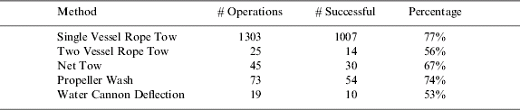
The results showed no significant correlations between iceberg size and probability of success. The correlation between iceberg shape and success was not distinct but indicated that it is more difficult to handle domed and wedge shaped icebergs than tabular shaped. With respect to correlation between success and sea state, the PERD database shows no general trend for towing in sea states with significant wave height, Hs, up to 5 m. For sea states with Hs between 5 m and 5·5 m there is a drop in the probability of success but this may be a consequence of a very limited amount of data in this interval. Usually, the single line towing method is used in the first attempt to move an iceberg. If this method is unsuccessful other approaches will be attempted. Due to this, the correlation between handling method and probability of success is somewhat biased. Table 2 shows the probability of success for the most recognised iceberg deflection methods. It should be noted that 87% of all operations in the database included single vessel floating tow rope, and that propeller wash and water cannon deflection usually is attempted only on minor icebergs. Details regarding the various approaches for physical iceberg management are well documented by Crocker et al. (Reference Crocker, Wright, Thistle and Bruneau1998).
Table 2. Probability of success versus deflection method (after Rudkin et al., Reference Rudkin, Boldrick and Barron2005).
With respect to Probability Of Detection (POD) of icebergs, Rudkin et al. (Reference Rudkin, Boldrick and Barron2005) presented an overview of the detection tools applied at Grand Banks and evaluated their efficiency. It was concluded that no single instruments will provide a 100% POD but that the present practise of applying a suite of tools including satellites, aircraft, radars and visual observations ensures an acceptable POD. In the period 2000–2004, 450 icebergs entered the tactical zones at Grand Banks and only two icebergs were undiscovered until they appeared within the tactical zone. Both these icebergs where dome shaped. After ten years with oil production at Grand Banks no severe accidents caused by impact with icebergs have been reported.
5. WEST COAST OF GREENLAND-FYLLAS BANKE
Similarly to the Grand Banks, the coast offshore Greenland is recognized for the occurrence of drifting icebergs. The largest icebergs are found in the northern part of the West Greenland coast where icebergs up to 32 million tons have been observed. At the Fyllas Banke more moderate icebergs are expected with an average mass between 0·3 and 0·7 million tons and a maximum of 2·8 million tons, Mosbech et al. (Reference Mosbech, Anthonsen, Blyth, Boertmann, Buch, Cake, Grøndahl, Hansen, Kapel, Nielsen, Von Platen, Potter and Rasch2000).
Over a period of 10 weeks during the summer of 2000, Statoil carried out exploration drilling at a water depth of 1150 m offshore central west Greenland in the Fylla field. During the drilling, valuable information regarding icebergs as well as practical experience regarding iceberg management was gained. The experiences are well documented by McClintock et al. (Reference McClintock, Bullock, McKenna, Ralph and Brown2002). There are many similarities between iceberg management at Fylla and at Grand Banks, however, there are some additional notes from the Greenland drilling (McClintock et al., Reference McClintock, Bullock, McKenna, Ralph and Brown2002):
• First, it was proved that it was possible to drill successfully at large water depth using dynamic positioning and comprehensive iceberg management services in an area subjected to an extreme number of drifting icebergs. During the ten weeks of drilling, 228 iceberg targets were tracked near the drillship. Out of these, 64 had to be physically deflected by the assisting supply vessels. Towing was successful 91% of the time and the reason for the unsuccessful cases was mainly towline slippage. Several icebergs with a mass over one million tons were successfully deflected; tow line slippage typically occurred during the towing of medium and small sized icebergs with smooth surfaces. The drill ship was forced off location on one occasion during the drilling. The cause was the approach of one unstable iceberg in poor weather and high sea conditions. Total downtime was 33 hours during the ten weeks of drilling.
• Three Norwegian supply vessels were hired for assistance during the drilling and none of these had any experience or training with respect to iceberg towing beforehand. Iceberg management experts from Canada were engaged in order to assist in iceberg handling. It is commented by McClintock et al. (Reference McClintock, Bullock, McKenna, Ralph and Brown2002) that all crew members picked up the deflection methods very quickly and performed extremely well. During the ten weeks, tow line fouling of the propellers occurred twice. In the first case the supply vessel had to go to shore for repair and was off site for three days.
• Despite a tow operation being considered successful, it was not always possible to tow the iceberg in the planned direction. In some events where wind, waves and currents made it impossible to tow in the planned direction, the iceberg would typically be guided through the ice management zones.
• For detection capabilities the marine radar was identified as the main source for iceberg detection. Satellite images from Radarsat were considered useful in a strategic sense, i.e. whether to send one of the supply vessels to land for re-supply or not. However, the information from the satellite was not used for tactical decisions. Only one fixed-wing aerial reconnaissance was performed at the beginning of the programme but was generally not found to be viable due to prevailing fog and poor visibility.
• Finally, the need for reliable information regarding metocean data and in particular current data is highlighted by McClintock et al. (Reference McClintock, Bullock, McKenna, Ralph and Brown2002). There are examples of icebergs, initially deflected into safe areas, that returned into the safety zones and posed a threat to the drilling operations.
6. THE ARCTIC OCEAN
As a part of the International Ocean Drilling Program (IODP) a multiple vessel expedition was sent into the Arctic Ocean in August 2004 to drill and recover deeply buried sediments at the Lomonosov Ridge. A summary of the expedition is given by Moran et al. (Reference Moran, Backman, Farell, Backman, Moran, McInroy and Mayer2006) and briefly reviewed in this paper. The convoy consisted of three icebreaking vessels; Vidar Viking, Oden and Sovetskiy Soyuz. For the purpose of this expedition, Vidar Viking had been converted into a drillship, Vidar Viking (Ice-10). The other two icebreakers were used to break ice during transit and to protect the drillship during drilling. Sovetskiy Soyuz is a nuclear powered Polar icebreaker while Oden is a Polar-20 icebreaker with diesel-electric machinery. These icebreakers are considered to be amongst the most capable icebreakers in the worldFootnote 4.
The water depth at the drill sites was in the range 1100–1300 m and it was planned to use dynamic positioning during drilling. However, prior to drilling, station-keeping tests showed that it was not feasible to keep position within limits during drilling. By manual positioning it was however possible to maintain Vidar Viking within a watch circle of 50–75 m for drilling to proceed. The ice concentration was 9–10/10 with 7–8/10 consisting of hard multi-year ice. The ice floe thickness was in the range 1–3 m and drift speeds were up to 0·3 knots.
With respect to physical ice management the most powerful icebreaker would typically work in circles some distance upstream while the second icebreaker would work in circles with smaller radius somewhat closer to the drillship. This concept is shown in Figure 4. It is reported by Moran et al. (Reference Moran, Backman, Farell, Backman, Moran, McInroy and Mayer2006) that the situations where it was most difficult to keep the drillship on location were those with variations in drift directions. In such situations information regarding ice drift became crucial. In order to provide such information a number of sources were applied. Drift buoys were deployed by helicopter on to the ice floes providing real time ice drift information. Helicopter reconnaissance was also used to map the local ice conditions. To provide an overview of the ice conditions, satellite images from Radarsat were applied. Together with an onboard weather team and traditional wind forecasts, the ice management team was able to predict ice movements in a 24–48 hours window.

Figure 4. The expedition 302 fleet during drilling operations. Ice drift direction is from top to bottom (photo taken by Per Frejvall, ref. Moran et al., Reference Moran, Backman, Farell, Backman, Moran, McInroy and Mayer2006).
Based on the results from the ice reconnaissance and information about the drilling activities, hands made ice alert reports which were submitted to the fleet manager. The reports included T-TimeFootnote 5 estimates. If ice management could not achieve a good ice condition window longer than the T-Time, drilling operations would be suspended. It was reported by Moran et al. (Reference Moran, Backman, Farell, Backman, Moran, McInroy and Mayer2006) that the ice alert reports served well as a tool for documenting the operations but were of limited value during critical times when rapid decision making was required. In such situations, the fleet manager relied most heavily on ice drift information and meteorological predictions. In total, during three weeks of stationary operations, drilling activities had to be suspended twice due to unmanageable ice conditions.
7. BARENTS SEA
Exploration for hydrocarbons in the Barents Sea started in the early 1980s in both the Norwegian and Russian sectors. So far there has not been any production from the part of the Barents Sea that is likely to be covered by ice or subjected to drifting icebergs. It is expected however, that the gas-condensate field Shtokmanovskoye, located in the central part of the Barents Sea, will be developed in the near future. At this field, both occurrences of sea ice and icebergs (possibly at the same time) will have to be expected during operations.
During a data collection expedition in the North Eastern part of the Barents Sea, an attempt to tow an iceberg frozen into the sea ice was carried out (Stepanov et al., 2005). The iceberg with a mass slightly less than 200 000 tons was surrounded by a concentration of 10/10 slightly deformed first year sea ice approximately 0·5 m thick. First, a lead favourable for towing was identified in the vicinity of the iceberg. Secondly, the towrope was attached manually around the iceberg and the iceberg was broken free from the surrounding sea ice by an icebreaker. When the iceberg was floating freely, the tow vessel took up the slack in the towrope and the tow started. Maximum vessel speed during towing was 1·3 knots. During the tow, it appeared not to be possible to steer the tow vessel due to heavy tension in the tow line. In order to avoid entering an ice field, engines had to be stopped until new slack appeared in the tow rope. Thereafter the vessel course was changed towards the nearby lead and the slack was taken up once more. When the tow was continued, one of the branches in the tow line ruptured and the experiment stopped. The tow line rupture was partly explained by damage caused by interaction with the ice and partly by uneven loads in the two tow line branches. Two of the important lessons highlighted from the experiment were the difficulty in keeping the planned course and the risk of being trapped in the sea ice during towing.
8. PECHORA SEA
Oil production on land in the Timan-Pechora basin started in 1985 and at about the same time shipments of crude oil started in the Pechora Sea. In 2000 an offshore oil-loading facility was built at Varandey in the Pechora Sea. The terminal is operated by Lukoil and has been operational from 2002 on a year-round basis. Oil is brought to the terminal by pipelines running from several onshore fields and is loaded into shuttle tankers by a Submerged Loading Terminal (ASLT).
The shuttle tankers connect to a single loading hose which also functions as a mooring line when approaching the terminal site. In order to connect to the hose, a pick up line and pick up buoy are used. The submerged buoy is released by acoustic link and is designed to break through the ice to bring the pick up line to the surface. The water depth is 12 m. The loading hose, which penetrates through the waterline, is designed to withstand forces from the sea ice. However, at least one diesel electric icebreaker is used to break and clear the ice around the hose. The loading operation spans over three tidal cycles (34 hours) so that the ice drift direction varies through the loading operation.
In accordance to APL (2007), loading operations have been carried out successfully since 2002. The system has been used in ice up to 1·5 m thick and in air temperatures down to −32°C. The hose has been replaced twice due to damage but the damage was not caused by ice. Ongoing loading has never been terminated but sometimes it has been necessary to wait for a suitable “ice window”.
9. SAKHALIN
The first oil production offshore Sakhalin Island started in 1999 from Sakhalin 2. Later, in 2005, oil from Sakhalin 1 also came on stream. So far, the production from Sakhalin 2 has been limited to approximately six months per year due to unmanageable ice conditions during wintertime.
In order to produce oil from the Piltun-Astokhskoye field (Sakhalin 2), the Vityaz Production complex was developed (Figure 5). The concept consists of the Molikpaq platform previously applied in the Beaufort Sea, a Single Anchor Leg Mooring (SALM) buoy and a Floating Storage and Offloading (FSO) tanker. In operation, the loading from the SALM buoy to the FSO is vulnerable to impact from ice (Keinonen, Reference Keinonen2006), thus operations are limited within the timeframe June to December. Both in the early and in the late season, ice management operations are required. There are many similarities with respect to methodology and tools applied at Sakhalin and in the Beaufort Sea. However, with respect to T-Time it takes a relatively long time (36–48 hours) to lower the SALM buoy safely to the seafloor. With respect to efficiency and operability it is reported by Keinonen (Reference Keinonen2006) that no failure in the risk control system has occurred since the start in 1999. However, potential production time has been lost due to presence of ice.

Figure 5. Vityaz Production Complex (from Offshore E-news, 2001).
With respect to new technology, it has been reported by Keinonen (Reference Keinonen, Evan, Neville and Gudmestad2007) that the introduction of icebreaking support vessels, equipped with azimuth propeller systems, has significantly improved the ice management capabilities during the recent seasons.
10. NORTH CASPIAN SEA
An exploration program was first started in the North Caspian Sea by the Kazakhstan government in 1992. The most recognised field in this region, Kashagan, was discovered in 2000 and production is now estimated to begin around 2010. The water depths in the North Caspian Sea are in the range 0–10 m and large long-term fluctuation in mean sea level have been seen over the last three decades. Short-term variations of ±2 m in water level may occur during periods with persisting winds from south/north. Due to the somewhat special conditions, attention is given to the use of physical ice barriers and development of low draft azimuth icebreaking supply vessels.
A barge drill rig was initially designed (Evers and Kuehnlein, Reference Evers and Kuehnlein2001) for all season exploration drilling in the North Caspian. In order to improve the ice clearing capability and reduce the ice loads, steel piles were driven into the soil in front of the barge. Physical barriers made of ice, gravel or steel caissons have also been used as passive ice management protection during exploration drilling in the North Caspian Sea. With respect to icebreaker support, two shallow draft Ice Breaking Supply Vessels (IBSV) were tailor-made for operations in the North Caspian (Arpiainen, Reference Arpiainen, Backstrøm, Juurmaa, Wilkman and Veldman1999). In accordance with specifications, the two vessels are able to perform ice management in waters as shallow as 3 metres and in level ice up to 90 cm thick (Wagenborg, Reference Wagenborg2007). One of the challenges when working in the shallow waters is to avoid getting ice under the hull and thus get stuck. The vessels are also supposed to influence the local ridging thus contributing to development of grounded ridges shielding the drill barge from ice actions. As for most modern icebreakers, the IBSVs are equipped with azimuth thrusters.
11. DISCUSSION
It is evident that offshore operations have been, and still are, successfully conducted in almost any kind of ice regime. Spanning from ultra shallow waters of 3 m in the Caspian to depths more than 1000 m in the Arctic Basin, various types of drilling operations have been carried out. Oil production is safely carried out in the iceberg stream at Grand Banks and even the heavily ridged multi-year ice in the Beaufort Sea has been handled in a safe way.
It is important to recognise that the ice management system has been a key factor when operating in ice covered waters. Without proper ice intelligence, risk evaluation, ice breaker assistance and the possibility to escape the drilling site it would probably not have been possible to work in the strong multi-year ice in the Beaufort. It is however, also important to note some shortcomings with respect to technology when working in ice covered waters:
• The possibility of handling icebergs when frozen into the sea ice is not documented.
• No single detector is able to detect all kind of ice features. It is likely that future projects will include a wide range of tools for ice detection as illustrated in Figure 6. Satellites, airborne ice recognisance, marine radars, ice drift buoys and visual observations from supply vessels have already been applied. The possibility of using Unmanned Aerial Vehicles (UAVs), multi beam sonar and Autonomous Underwater Vehicles (AUVs) should be considered in the future. An important challenge connected to this is the need to develop tools for gathering, analysing and presenting all data in a quick and efficient manner.
• Use of Dynamic Positioning systems is not well documented for vessels working in the sea ice. This means that use of mooring lines will be required. Use of manual positioning should be avoided due to the high risk of human errors.

Figure 6. Illustration of a possible future physical ice intelligence system.
With respect to new technology, it is noted that the ability to work in ice has been significantly increased by the use of Azimuth thrusters. Such thrusters have been reported to work well in connection with icebreaker escort services for more than a decade and new experience from Sakhalin and the North Caspian Sea indicates that the Azimuth equipped vessels also work efficiently when protecting drilling and loading operations.
One of the most important lessons from the various projects is that ice management systems need to be included at an early stage in the operation planning and concept evaluation. In particular, ice management systems need to be taken into account when considering whether to use a fixed structure or a structure with the ability to move off location when threatened by ice. A question arising in connection with new projects is how to quantify the effect of ice management in the design of a concept. Further work should focus on how to use historical ice management data together with environmental and structural information in a probabilistic analysis in order to ensure that the concept's integrity is kept.
12. CONCLUSIONS
The major conclusions regarding ice management are:
• Exploration and/or production drilling have been performed successfully in a wide range of Arctic conditions and at water depths ranging from a few metres to more than thousand metres.
• Comprehensive use of ice management is explained as a key factor for the success.
• Technology for iceberg handling in open water is considered as proven.
• Technology for handling icebergs frozen in the sea ice is not considered proven.
• Technology for breaking sea ice is proven for a wide range of severe conditions including multi-year ice and ice ridges. However, it is expected that there may be ice conditions more severe than the most powerful icebreakers can handle.
• Use of azimuth propeller systems on icebreakers have been seen to contribute to significant improvements in the ice breaking capability and more important for offshore operations; the ability to clear ice around a structure.
• Technology for detection and tracking of ice features will have to include a wide range of tools. Use of unmanned aeroplanes, unmanned underwater vehicles and multi beam sonar may be considered as possible future supplements to existing ice detection tools.
• It is recommended that evaluation of ice management capabilities is performed at an early stage when planning new operations and in the evaluation of new drilling and production concepts.
• Future work regarding methodology for implementation of ice management capabilities in concepts/operations is recommended.


