Introduction
Climate scientists have introduced the term ‘Anthropocene’ to describe the period of Earth's history in which human intervention in the environment began to have an impact on a planetary scale. While the term was initially coined with reference to chemical changes observed in the atmosphere and oceans, it also encompasses phenomena as diverse as species extinction and physical change to the surface of the Earth through land clearance, agriculture, urbanisation and resource extraction (Crutzen Reference Crutzen2002; Szabo et al. Reference Szabo, Loriant and Lóczy2010; Steffen et al. Reference Steffen, Grinevald, Crutzen and McNeill2011; Robin Reference Robin2013). Archaeology, with its emphasis on the study of human-environment interaction over the long term, is a discipline with obvious potential to contribute to debates about the Anthropocene (Edgeworth Reference Edgeworth, Waters, Zalasiewicz, Williams, Ellis and Snelling2013; Head Reference Head2014). This is already evident in a small but growing literature on the topic, including special issues of Anthropocene (e.g. Lightfoot et al. Reference Lightfoot, Panich, Schneider and Gonzalez2013; Braje & Erlandson Reference Braje and Erlandson2014; Erlandson & Braje Reference Erlandson and Braje2014) and the Journal of Contemporary Archaeology (e.g. Edgeworth Reference Edgeworth2014; Kelly Reference Kelly2014) that featured discussions of the topic, together with the recent Debate feature in Antiquity led by Todd Braje (Reference Braje2016, and responses therein). Archaeological approaches to mapping the spatial distribution of human activity, and analysing and interpreting changing patterns of behaviour over time are particularly relevant for understanding the nature, extent and timing of significant anthropogenic environmental change (Crutzen & Steffen Reference Crutzen and Steffen2003; Lewin & Macklin Reference Lewin and Macklin2014). Archaeology is uniquely placed to participate in Anthropocene debates because it is the only discipline to study human society that also deals with temporal scales approaching those of geology. Questions of analytical scale that reconcile archaeologically and historically observable human action with global geological change are not new in archaeology (e.g. Bintliff Reference Bintliff1991; van der Leeuw & McLade Reference van der Leeuw and McLade1997). Understanding the Anthropocene requires a multi-scalar approach that places local archaeological sites within a planetary framework, and that situates short-term human action within geological timelines lasting hundreds of millennia.
The acceleration of anthropogenic change in the last 200 years is visible in former European colonies (Lightfoot et al. Reference Lightfoot, Panich, Schneider and Gonzalez2013). In Australia, Aboriginal land management gradually reshaped the environment over more than 40000 years (Gammage Reference Gammage2011). European settlers, arriving after 1788, dramatically increased the pace and extent of change. They brought with them a world view that relied on much more extreme forms of intervention in the environment, including the introduction of new plant and animal species, plough agriculture, large-scale deforestation, and industrialised mining (Blainey Reference Blainey1963; Young Reference Young1996). All these factors had serious implications for the Australian environment, but here we are specifically concerned with the effects of mining, particularly the related, broader impact on rivers.
Recent work on rivers of the Anthropocene recognises waterways as complex biophysical systems transformed by extensive and pervasive human impacts (Walter & Merritts Reference Walter and Merritts2008; Kelly Reference Kelly2014; LeRoy Poff Reference LeRoy Poff2014). Rivers altered by human intervention have not been destroyed or ‘unmade’, but have instead become something new. The notion of a modified waterway as an ‘organic machine’ integrates the physical changes wrought by people with the persistent natural processes of flowing water (White Reference White1995). Rivers transformed by human agency thus represent the entanglement of nature and culture, as water flowing through the landscape connects and integrates people and places through time (Strang Reference Strang2004; Edgeworth Reference Edgeworth2011). Considering rivers as artefacts provides a deeper understanding of the role of humans in shaping the physical landscape during the recent past. The formal characteristics and spatial distribution of altered river systems provide evidence of human intervention, while the timing of modifications demonstrates the accelerated change associated with the Anthropocene.
Changes to river systems that continue to have an impact today are an example of the anthropogenic environmental change that was a fundamental material signature of settler societies in the nineteenth century. During the Australian gold rush in the second half of that century, the miners’ need for water and the quantities of waste-water that they produced resulted in a period of intense human modification of river systems, particularly in the colony of Victoria. Thousands of megalitres of water were diverted within and between catchments every day and many tonnes of sediment flowed downstream, reshaping channels and inundating floodplains. The rivers and associated floodplains in Victoria today are cultural artefacts that have been shaped over the past 150 years through a combination of human activity and the resilience of natural systems.
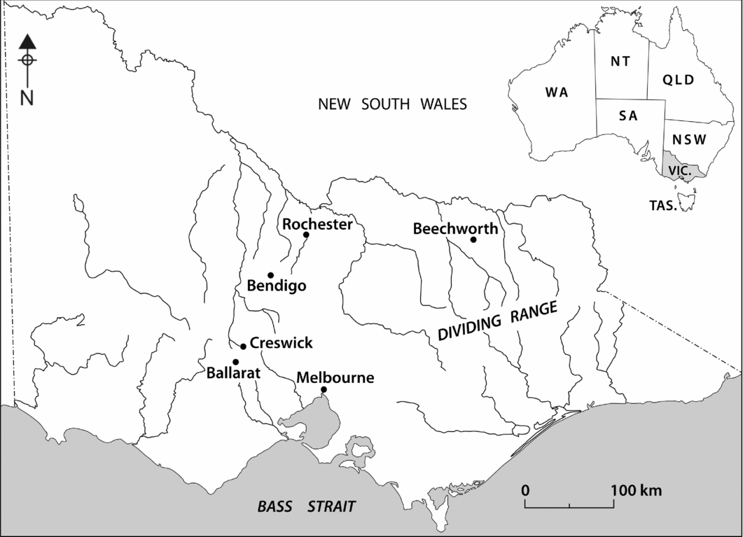
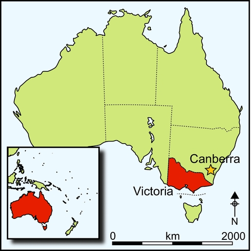
The significant and long-term impact of mining on Victorian riverine landscapes is demonstrated by case studies in the mining districts of Creswick and Beechworth (Figure 1). Here we have mapped and recorded extensive and interconnected networks of water supply infrastructure, mining remains, eroded and channelised rivers, and inundated floodplains (Davies et al. Reference Davies, Lawrence and Turnbull2011). Together, these features constitute an intensely modified anthropogenic landscape characteristic of industrial mining around the world, including California, the Klondike and New Zealand (Morse Reference Morse2003; Isenberg Reference Isenberg2005; Hearn Reference Hearn, Pawson and Brooking2013). These relatively recent mining activities replicate patterns produced by Roman and medieval mining in Cornwall and Spain (Willies Reference Willies1989; Thorndycraft et al. Reference Thorndycraft, Pirrie, Brown, Murphy and Wiltshire2003), but their scale and global distribution exemplify the acceleration of Anthropocene change over the past 200 years.

Figure 1. The state of Victoria, showing places mentioned in the text.
Rivers of gold
Gold was discovered in the Australian colonies of New South Wales and Victoria in 1851, shortly after it was found in California in 1848 (Blainey Reference Blainey1963). Hundreds of thousands of people travelled to Victoria's rich ‘diggings’ during the next few years: one of the largest and most rapid mass migrations in human history. This event transformed the colony from a sleepy pastoral outpost of 77000 people to a booming, industrial-based economy of over half a million in only a decade (Bate Reference Bate2001). Gold from Victoria accounted for one third of global production in the 1850s, and by the outbreak of the First World War, more than 2600 tonnes of gold had been extracted (Phillips & Hughes Reference Phillips and Hughes1996: 256).
Gold extraction moved from an initial concentration on easily worked surface deposits in the 1850s to deeper and more complex industrial mining of underground quartz reefs and the beds of ancient, buried rivers (Davey & McCarthy Reference Davey and McCarthy2002). Miners developed increasingly sophisticated methods for recovering gold, including ‘puddling’ heavy clays, sluicing thick alluvial deposits on hillsides, dredging rivers, crushing hard rock deposits and processing chemically complex ores by roasting, chlorination and cyanidation (Rae Reference Rae2001; Birrell Reference Birrell2004). All of these demanded large quantities of water for transporting and washing ore, and for powering the water wheels and steam engines that drove the machinery.
Finding reliable sources of water in Victoria was a challenge. Rainfall is variable and mostly falls in winter and spring (July to October); surface evaporation is high and stream flows are generally small. From the outset of the rush, miners built large and complex water systems to obtain reliable water. This included reservoirs that held hundreds of megalitres, and lengthy water races (ditches) to carry water to where it was needed, which transferred large volumes between catchments when necessary (Smyth Reference Smyth1979: 547). Conflicts over the control of water resulted in the emergence of sophisticated new legal systems that transformed water into a tradeable commodity (Davies & Lawrence Reference Davies and Lawrence2014).
Waste-water discharged from apparatus such as puddlers, sluices, dredges and stamp batteries was a significant by-product of mining processes. This water was laden with sediment and, in some cases, contaminated with the mercury used in the extractive process. As it flowed downstream, the higher volumes of water caused erosion in some places while flooding in other areas deposited sediment layers up to 3m thick (Lawrence & Davies Reference Lawrence and Davies2014). The sludge affected land up to 60km downstream from mining districts and buried thousands of hectares in deposits that are still identifiable in soil profiles today (Peterson Reference Peterson1996). Mining-induced erosion created ‘sand slugs’ in waterways that changed flow regimes and aquatic habitats. A century after the gold rush, the altered hydrology of stream flows from the diversion of water, post-sediment alluvium and legacy sediments, and sand slugs in the rivers themselves, all present challenges for catchment management even though the origins of the changes in the historical mining industry have not been widely recognised.
The change wrought by mining to Victoria's river systems is only apparent on a landscape scale. At individual archaeological sites, the subtle evidence of water-related infrastructure, such as small earthen dams and fragments of water race, appears of minor importance compared to imposing brick and stone remains of machinery footings and 30m-high piles of waste rock. At a catchment level, however, the impact comes into focus and its significance can be understood. Archaeological evidence of water encompasses large reservoirs in the upper portions of watersheds, thousands of kilometres of races that carried water to the mines, thousands of hectares of land sluiced and dredged, and the altered contours of downstream river channels and floodplains.
Creswick and Beechworth are both centres of large goldfield districts that encompassed numerous outlying mines and settlements. Gold was discovered at Creswick in September 1851, and in Beechworth five months later; miners flocked to work the rich, gold-bearing sands and gravels in the creeks and surrounding hills. The towns followed the trajectory of other goldfields in Victoria, enjoying prosperity as a result of richer and more industrialised mining from the 1860s–1880s, and gradually fading as the accessible gold deposits were worked out by the end of the century. Archaeological research at both places has involved the construction of a GIS database of information compiled from a combination of documentary sources, historical maps of mining and water leases, mapping by orienteering groups and local residents, Google Earth and LiDAR imagery, and archaeological survey.
Upstream: water supply systems
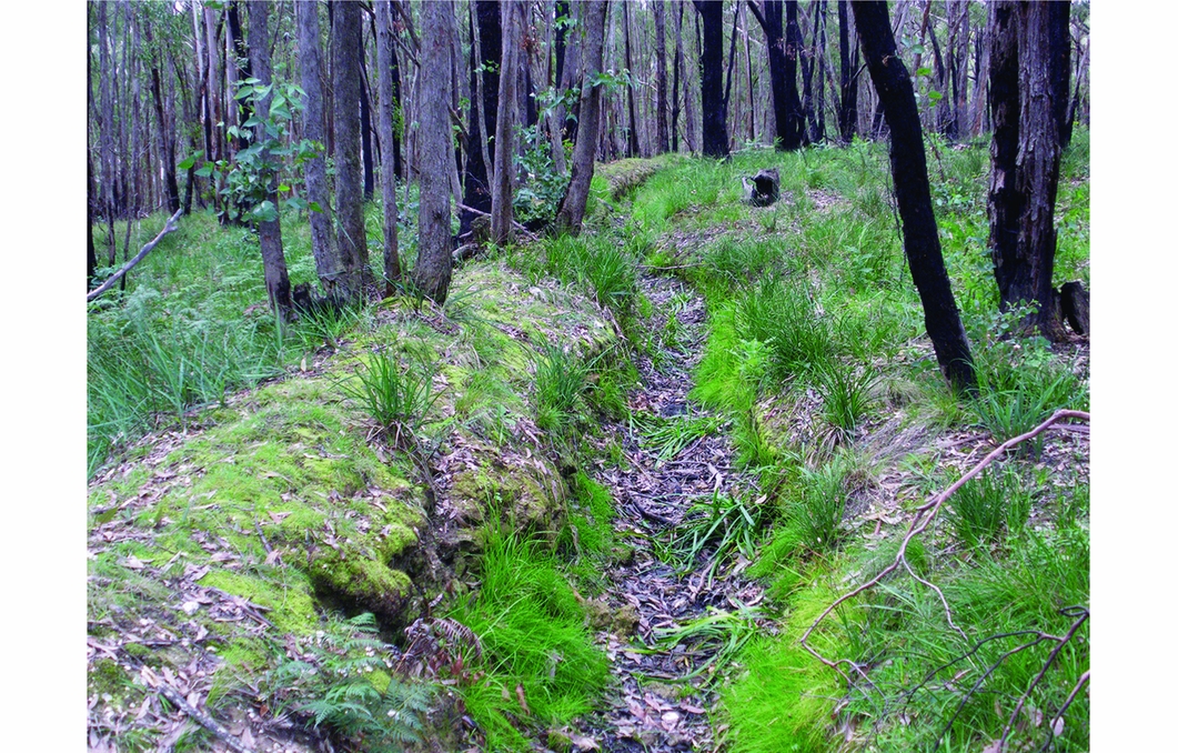
At the top of the catchments, miners diverted water from natural drainage systems and collected and stored it for use in their mining claims. Archaeological sites include dams and reservoirs, enlarged natural springs and networks of races to carry the water (Figure 2). By 1868, government officials recorded nearly 4000km of water races and 44 major water storage reservoirs, some holding more than 300 megalitres of water (Smyth Reference Smyth1979: 549–50). A small but significant number of reservoirs and channels have been improved and deepened, and now form part of municipal water systems that supply local towns. These archaeological sites are the remnants of a network that was once far more extensive. The networks constructed at Creswick and Beechworth illustrate what was involved in this undertaking and what has survived archaeologically.

Figure 2. Bragg's water race at Creswick, Victoria.
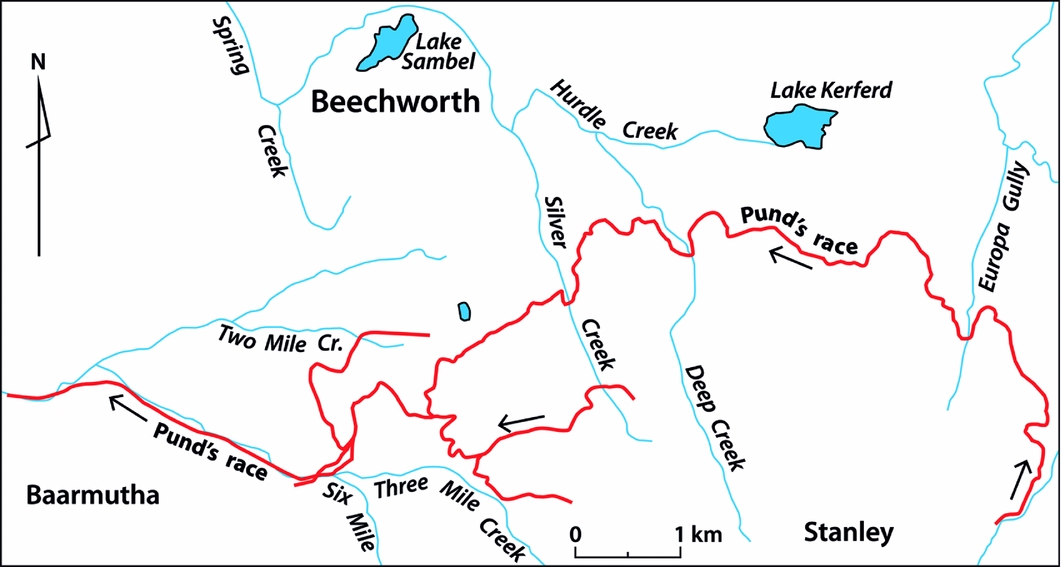
Archaeological evidence demonstrates the density of infrastructure that characterised the supply of water for Victorian mining. In an area of State Forest covering some16km2 at Creswick, over 150km of water races have been mapped archaeologically, along with 27 storage reservoirs of varying capacity. The Beechworth region is similarly dense with archaeological evidence of water management but of a much greater scale and complexity. By the late 1860s, 77 water race systems around Beechworth were licensed to carry a combined total of 148 megalitres per day. One race system, mapped archaeologically, extended 28km from source to mine workings. In some places up to five independent race networks ran in parallel within only 20m, crossing and re-crossing in a complex tangle of competing interests (Figure 3).

Figure 3. Overlapping water races at Beechworth.
The operations of a typical water supply company are illustrated by the Humbug Hill Sluicing Company at Creswick (Davies et al. Reference Davies, Lawrence and Turnbull2011). The eight partners included English, Irish, Portuguese and Filipino miners. They worked successfully as alluvial miners on a small scale and gradually built up a substantial network of races and reservoirs, beginning in the late 1850s. By the early 1860s, their business included supplying water to other miners, with extensions to their race network far beyond their own mining leases. The dam and water race were purchased by the Creswick Council in 1880 and thereafter contributed to the town's domestic water supply. Much of the company's infrastructure remains well preserved today, including the clay wall of the 3.6ha reservoir, and the main supply race that survives as a ditch, 1m across and up to 1.2m deep, running for 11km between the reservoir and the company's mining lease at Humbug Hill.
One of the largest and most intact water supply systems at Beechworth was built by German migrant John Pund. The supply race originated in tunnels cut into artesian springs and ran for over 28km to Pund's sluice works (Figure 4). LiDAR data and archaeological survey indicate that much of the race survives as a cut of up to 1m in depth that still carries running water. Pund's race diverted water from the drainage of the Kiewa River westward into the catchment of the Ovens River and across the plains of north-eastern Victoria. The race is the physical manifestation of a series of water-right licences that Pund gradually acquired over many years between 1865 and his death in 1915. By that time he is estimated to have produced 771kg (24 800oz) of gold through his various mining interests, all supplied by the water he controlled (Lloyd Reference Lloyd2006: 156). Pund was typical of water merchants in the Beechworth region who made fortunes out of manipulating water and selling it to others, and his race network is just one of dozens remaining in the area.

Figure 4. John Pund's water race at Beechworth.
Midstream: using the water
Archaeological sites associated with mining are abundant in Victoria. Over 1600 mining sites are listed on the Victorian Heritage Inventory, and over 500 of those include features associated with water management, including dams and reservoirs, water races and tail races, and sluicing areas. The physical evidence of water use is closely associated with the remains of mining activity, including shafts, surface workings, machinery foundations and processing equipment. Most of these sites are not immediately adjacent to rivers or streams, but they are connected to riparian landscapes by the races that delivered fresh water and bore the waste-water away.
The most common types of archaeological evidence on surface alluvial sites are puddling troughs, sluiced gullies and dredge ponds, all of which are associated with using water to process gold-bearing soil. Puddlers were large, circular, earthen troughs into which water and gold-bearing clays were mixed to a slurry by a horse-drawn paddle. The waste clay was released through an outlet, leaving the heavier gold to be scraped off the bottom. Up to 2000 puddlers were recorded on the Bendigo goldfield alone in 1857, using almost 70 million litres of water per day, and releasing vast quantities of mining sludge into nearby creeks and gullies (Sullivan et al. Reference Sullivan, Carpenter and O'Keefe1859: 26).
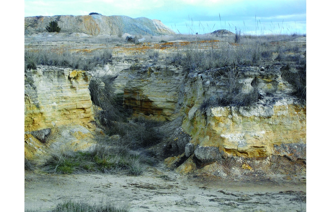
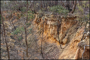
Sluiced ground can be extensive and often covers many hectares. Ground sluicing was a local adaptation of the ancient Cornish technique of tin-streaming, and was brought to Victoria by Cornish migrants, and by miners with experience in California (Lawrence & Davies Reference Lawrence and Davies2015). The process removed the topsoil so that sites came to resemble gravel pits or quarries, ranging in depth from 1–30m below the surrounding ground surface (Figure 5). Hydraulic sluicing was an industrialised, larger-scale version of ground sluicing that was invented in California in the early 1850s (May Reference May1970). The technique was in use in Victoria by 1859 and used even greater quantities of water directed through a gradually narrowing hose. The high-pressure jet simultaneously undermined the base of the working face and washed away the debris, leaving the heavier gold to be retrieved from wooden box drains or tail races. This process was used to remove thick bands of alluvial gravels, and it left behind deep pits and cliff faces tens of metres high.
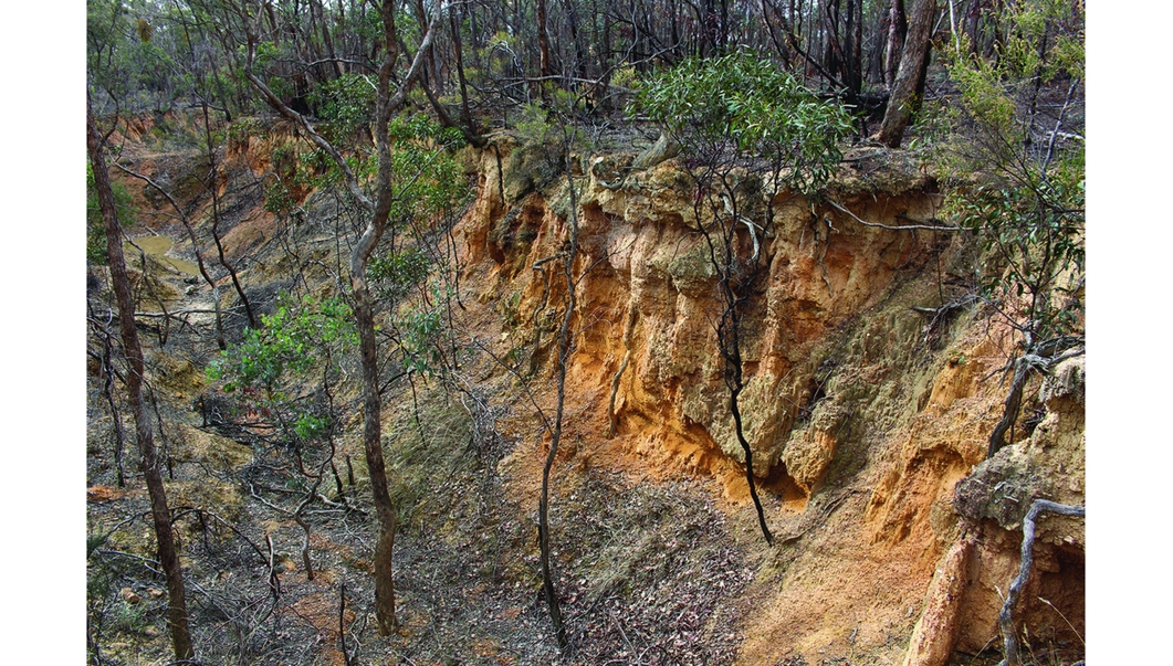
Figure 5. Sluiced gully at Castlemaine.
Dredging replaced sluicing in Victoria as the main form of alluvial mining from 1900 to the Second World War. Dredges operated on floating pontoons on or adjacent to waterways, and incorporated a continuous chain of buckets that dug into alluvial gravels, extracted the gold, and discharged the waste to the rear. Dredges recycled the water in their ponds, but their location along streams and rivers meant that they did extensive damage to floodplains over large areas.
Underground mining also used large volumes of water to drive machinery and flush ores through crushing equipment. Boilers in steam engines needed a steady supply of clean water, while some mines also used a water wheel to drive batteries and other equipment. Ore-processing involved physically separating grains of gold from the parent rock, with water used at each stage of the process. After crushing in stamp batteries (a crushing mill that used falling weights to reduce gravels to sand), the water and sand slurry flowed onto inclined wooden tables covered with a thin sheet of mercury. The gold amalgamated with the mercury, and the sand was flushed away as ‘tailings’. Tailings piles left behind by water are thus part of landscapes of water use. They survive at more isolated mines where some of the tailings were kept on-site in settling dams. A century later the water has evaporated and the timber retaining walls have rotted away, leaving only the fine silts in laminated mounds 3m high and covering several hectares (Figure 6).
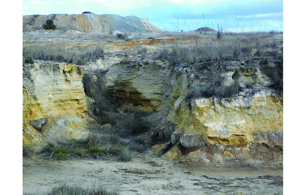
Figure 6. Mine tailings at Creswick; the tailings are the laminated deposits in the foreground; the large mound in the background is mullock, or waste material.
Downstream: waste
By the time the water had moved through mining systems, it was heavily polluted with sediment and often contaminated by mercury and other chemicals used in processing. Floodplains where the waste settled, and river channels scoured by its passage, are the final components of these riverine mining landscapes. Sediment-laden water, or ‘sludge’, was discharged from puddlers, sluices, dredges and crushing equipment through tail races and onto the nearest vacant ground or into the nearest stream (Lawrence & Davies Reference Lawrence and Davies2014).
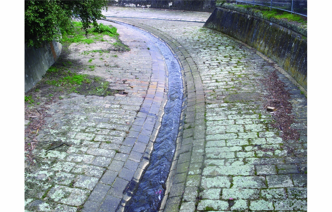
Complaints about sludge began on the goldfields in the 1850s and continued for the next 100 years. As sludge flowed downstream from the mines it choked creeks and gullies, buried bridges, destroyed market gardens and inundated farmland. Features associated with the management of sludge are readily recognisable as archaeological sites; for example, the tailing mounds at the Berry Deep Lead mines near Creswick, and the tailings dam that John Pund created below his sluiceworks at Baarmutha. Lengthy and substantial tail races that drained the sluiced areas have also been recorded at many mining sites. The stone and brick-lined stormwater channels in central Ballarat and Bendigo are heritage-listed places that still function as part of municipal infrastructure. These channels are actually the original creek beds, straightened, relocated, deepened and lined so as to carry sludge away from mining areas and townships (Figure 7). They are rivers turned into artefacts for human use.

Figure 7. Sludge channel at Ballarat.
Other archaeological sites are at a different scale altogether: new landforms created by the water-borne sediment released by mining. Due to their size and the resilience of natural systems, their human origins are hard to identify. These sites encompass two kinds of change: the altered shape of rivers, and changes to the form of floodplains. Hodgson Creek at Tarrawingee is an example of the former, where the creek has been straightened and deepened to deal with sludge from mining in the hills upstream. Another example is the increased sedimentation and presence of sand slugs in Reedy Creek, downstream from Beechworth. Sand slugs change the hydrology of stream flows by creating shallower, smoother stream beds with fewer pools, increasing flood events and altering the ecology by reducing habitat.
Floodplain changes have been most thoroughly documented downstream of Bendigo. Mining sludge reported in the 1859 Royal Commission has been identified geomorphologically over a wide area in the agricultural land west of Rochester (Peterson Reference Peterson1996: xi). Test samples throughout the region reveal a distinct layer of sediment characterised by a hard-setting clay capping and the presence of sub-angular quartz chips. Natural drainage patterns in the area have also been disrupted, and small tributaries inundated, so that there is very little natural relief, in contrast to adjacent areas that remained free from sludge. It is estimated that some 700km2 in the region have been affected by Bendigo's sludge. Legacy sediments such as these are among the key geomorphological markers of the Anthropocene, providing a valuable record of the history of past human alteration of the landscape (James Reference James2013: 16).
Archaeological signatures of anthropogenic change
The resilience of waterways has been such that in most cases the presence of sludge has been all but forgotten in Victoria, even by professional catchment managers. The archaeological, geomorphological and chemical investigation of downstream mining legacies is still in its infancy, with only a handful of academic studies assessing the extent of the impact (e.g. Peterson Reference Peterson1996; Sultan Reference Sultan2006; Davies et al. Reference Davies, Lawrence and Turnbull2015). Numerous studies elsewhere, however, have established that it is possible to identify mining waste deposited as sediment on floodplains and in estuaries downstream from mining regions. In Cornwall, sediment from medieval tin mining choked the Fowey River, ultimately resulting in the abandonment of Lostwithiel as a river port (Gerrard Reference Gerrard2000: 61), while in Tasmania geomorphologists have identified mining waste as the source of sediment that filled the Ringarooma River (Knighton Reference Knighton1987). The mining origins of these legacy sediments can be ascertained through micro-stratigraphy, sub-surface coring and chemical testing, and they can be dated to establish a fixed chronology for the changes. In California, sub-surface coring has identified millions of cubic metres of mining sediment stored along river basins draining the goldfields (James Reference James1989). At locations away from the main river channels, mine tailings were identified as thick sequences of laminated silt and fine sand, while in other locations the formation of sandy, braided stream deposits is indicated by the presence of trough-set, cross-stratified sand (James Reference James1989: 575–76). Macroscopic changes in soil profiles associated with mining have similarly been identified as loose, weakly bedded sands and silty sands in exposed river terraces downstream from ancient tin mines on Dartmoor in the UK (Thorndycraft et al. Reference Thorndycraft, Pirrie, Brown, Murphy and Wiltshire2003: 23).
XRF testing for mineral content has also been used to identify mining-related sediments along rivers draining Dartmoor (Thorndycraft et al. Reference Thorndycraft, Pirrie, Brown, Murphy and Wiltshire2003: 21–23). Stratigraphic layers in exposed river terraces and palaeochannels showed elevated levels of tin associated with the deposition of up to 1.5m of sediment. AMS dating of the sediments provided further confirmation of anthropogenic origins in the medieval tin-mining boom. Sediments in the basin of the River Tyne in England have been found to contain elevated lead and zinc levels associated with historical metals mining in the adjacent Pennines region (Macklin et al. Reference Macklin, Ridgway, Passmore and Rumsby1994: 690). These studies all demonstrate that the anthropogenic sediment layers have characteristics that can be considered artefactual. Their form, age and spatial distribution are distinctive and consistently recurring. Mapping similar sediments in Victoria is the objective of work recently commenced by the authors as part of the project ‘Rivers of gold: the legacy of historical gold mining for Victoria's rivers’, for which Australian Research Council funding was received in 2015. The project brings together archaeologists, fluvial geomorphologists and environmental chemists to identify and document legacy sediments and changes to river morphology and hydrology associated with mining activity. In Victoria, it is anticipated that legacy sediments in mining rivers will have elevated levels of gold due to inefficiencies in early mining methods. The sediments are also expected to contain mercury, used in recovering gold, and arsenic, which was released into the atmosphere when ores were roasted and subsequently washed into waterways (Rae Reference Rae2001; Davies et al. Reference Davies, Lawrence and Turnbull2015).
Conclusion
The archaeological analysis of Victoria's rivers contributes to understandings of the Anthropocene in several ways. Firstly, it makes clear that waterways are artefacts and the products of human activity—part of a global suite of changes in the Earth's surface attributable to human intervention. Secondly, it demonstrates that changes produced by mining are long-lasting and visible in the stratigraphic record. These layers are geologically distinct and can be clearly and unequivocally linked to human activity. Thirdly, in common with other processes where Anthropocene change has been identified, mining rivers reveal an intensification of activity in the past 200 years as a result of European expansion and the Industrial Revolution (Crutzen & Steffen Reference Crutzen and Steffen2003; Lewin & Macklin Reference Lewin and Macklin2014). Finally, the analysis demonstrates the importance of scale when interpreting change. Small-scale sites that provide evidence of local activities can be understood as components of an expanding web with global consequences.
The shape and flow of Victoria's creeks and rivers have been altered by human activity in the historical past. They are artefacts created and manipulated by gold-mining activity as miners added and removed water from natural systems, created new channels and filled old ones, discharged heavy flows that caused erosion and introduced sediment loads that created new soil layers in the surrounding countryside. Subsequent agricultural activity contributed to these changes, but the initial and most intense period of disruption was during the mining boom that lasted from 1851–1914.
Changes to mining rivers are long lasting. They are still visible today in the contours of the land and they will remain into the future as new stratigraphic layers on the Earth's surface. In some cases, change is readily apparent in erosion and downstream sedimentation. In other cases, revegetation and the establishment of new ecological communities in riparian zones may give the appearance of recovery. In such cases, evidence may be subtle and require detailed chemical and stratigraphic analysis to identify the mining origins of sediment layers. Resilience in natural systems can rework the impact of human activity and may mask its extent, but permanent landscape change is nevertheless apparent.
While Cornwall and Spain present landscapes of ancient artisanal mining, Victoria, California and the Klondike have been shaped by mining on an industrial scale. The gold rush was part of a profound acceleration of mining-related change. Miners who came to Victoria in the nineteenth century used Old World techniques with origins in the Roman and medieval periods, techniques that had already irrevocably changed the Cornish landscape by the fifteenth century through land clearance and river sedimentation. The industrialised techniques developed during the gold rush, such as hydraulic sluicing and dredging, took that several steps further. Vast areas were rapidly denuded of soil and huge quantities of sediment were sent downstream. Moreover, landscapes that had taken hundreds of years and multiple generations to form in the Old World were transformed in decades—within a single human lifetime—in the colonies.
A multi-scalar approach to analysis highlights the extent and significance of change. At the local level, archaeological sites associated with water use in mining can be subtle and fragmentary, but the flow of water between reservoirs, mining areas and floodplains connects them with much larger and more complex landscapes. The cumulative impact of mining on Victoria's rivers is immense, as 22 of the 29 major river systems featured gold mining within their catchments. Activity at single sites was multiplied a thousand times and spread across the colony, resulting in the creation of new landscapes far beyond the site or even the mining district. Industrial mining and the global gold rush pushed these changes even farther, to California, New Zealand and the Klondike in the nineteenth century, and into developing countries such as Papua New Guinea, Brazil and Nigeria in the twentieth century (MacMillan Reference MacMillan1995; Bridge & Fredriksen Reference Bridge and Fredriksen2012).
Scientists at some future time may compare mining-related strata around the world and note that they vary in age and extent, from Cornwall's medieval mining to Nigeria's twentieth-century rivers. These variations are sufficient to probe human agency and historical contingencies, the circumstances of colonisation, race and empire, and the dynamics of power that shape individual experience and determine political outcomes. On the geological and planetary scales at which the Anthropocene will be measured, these differences will disappear. What will remain is a series of structurally similar deposits dating to within a few thousand years and occurring at multiple locations around the globe. It will be evident that they were produced by a unifying global process: the human drive to exploit the Earth's mineral wealth.
Acknowledgements
This research was funded by the Australian Research Council. We thank Ian Rutherfurd, Ewen Silvester, Darren Baldwin and Mark Macklin for discussions about the new project. David Frankel and the anonymous reviewers provided valuable critical feedback in the preparation of this paper.