


Introduction
In Western Europe, and more specifically Western France, remains of Neolithic domestic occupation are usually inconspicuous, in contrast with contemporary stone-built funerary monuments, which persist as upstanding markers in the landscape (Giot et al. Reference Giot, L’Helgouac’h and Monnier1998; Scarre Reference Scarre2011). These inconspicuous remains are mainly negative features, postholes or ditches; occasionally, daub fragments from walls are found. In Western Europe the existence of load-bearing, earthen-walled buildings are very rarely reported. The discovery of such architecture at Lillemer, a causewayed enclosure in Brittany, offers a new opportunity to understand domestic structures in the Middle Neolithic in Western France. The wetlands in the vicinity of this site also revealed numerous organic archaeological remains. The Neolithic occupation started in the mid-fifth millennium BC and seems to have ended within the first quarter of the following millennium. Northern Brittany, between the Morbihan and the Plaine de Caen, has traditionally lacked archaeological evidence from this period. This discovery is all the more significant in that the southern shore of the English Channel has in recent years become a strategic research area for discussions focusing on the Mesolithic to Neolithic transition in Britain and Ireland.
A rocky hill emerging from surrounding marshes
At the inner end of the Dol-de-Bretagne marshland, slightly behind the bay of Mont-Saint-Michel, rises the rocky hill of Lillemer (Figure 1). Surface surveys revealed a Middle Neolithic site, spreading over 30ha. And it was the remains preserved in the wetland that first drew our attention to this site.

Figure 1. Location map and aerial photograph of the site of Lillemer.
The earliest evidence for human activity at the site dates to the mid-fifth millennium BC, and consists of wood chips, pruned branches and a polished stone axehead, uncovered at the base of the organic layers (Laporte et al. Reference Laporte, Bizien-Jaglin and Guyodo2011). Two linear and parallel square-sectioned channels, discovered at the interface of the peat and white clay layers, may represent very old drag marks, possibly caused by branches forming a travois or sledge. Two trackways, one made of planks, the other of branches (Laporte et al. Reference Laporte, Guyodo, Bizien-Jaglin, Bernard, Bertin, Blanchet, Dietch-Sellami, Guitton, Hamon, Hamon, Lemouland, Lucquin, Noslier, Quesnel and Besse2007), are slightly more recent. One of the planks has been dated to 5115±30 BP, or 3978–3801 cal BC (2σ); these represent the earliest remains of this type from anywhere in Atlantic Europe. Significant features were found associated with these routeways, including a hearth on a layer of willow sticks (Figure 2) and a standing stone embedded at the track side. These tracks are flanked by middens, rich with Neolithic material, converging towards the hill of Lillemer.

Figure 2. Evidence of occupation of the marshy areas around the hill of Lillemer: A) wooden stick; B) hearth; C) vessel crushed in situ; D) plank and branches track; E) complete vessel.
It is peat that provides information about the natural environment during the Neolithic. Faunal remains are well preserved, which is sufficiently rare in Brittany to be noteworthy. The identification of subfossil wood, both natural and worked, unearthed in the marsh, combined with pollen analysis, shows that oak, alder and willow were dominant. The oak samples are currently contributing to the construction of a regional dendrochronology reference curve. Outside the British Isles, waterlogged Neolithic remains are scarce in Atlantic Europe.
A Middle Neolithic causewayed enclosure
During the Middle Neolithic the hill of Lillemer was entirely enclosed by a bank, preserved to a height of more than 1m, and 7–8m wide (Figure 3). This earthwork runs for over 1.5km and is still visible in the landscape. The structure, stratigraphy and sequence of construction of the bank seem to vary considerably. It incorporates the remains of wooden fencing, although the wood itself is seldom preserved. Radiocarbon dating places the sapwood outer tree rings of these sharpened posts in the last quarter of the fifth millennium BC; for example, post 94 dated to 5320±30 BP, or 4243–4047 cal BC (2σ). An individual burial had been cut within the bank itself, and appears broadly contemporary with the erection of numerous dolmens elsewhere in Brittany.

Figure 3. Map and photograph of the Lillemer causewayed camp: excavations and survey.
The perceived height of the bank was enhanced by the digging of a ditch, itself filled with the same peaty layers as those in the surrounding marshes. The size and profile of the ditch varies from sector to sector. On the northern side, it is composed of conjoined units, each 2–3m long; it measures 2m wide and in some places is less than 0.3m deep. On the south side, the ditch circuit seems more continuous but does not exceed 1m wide. The shallowness and topographical position distinguish this ditch from those attributed to the same period at Sandun in Loire-Atlantique to the south or Goulet in Calvados to the east (Letterlé Reference Letterlé, Cahen and Otte1990; Ghesquière et al. Reference Ghesquière, Giazzon and Marcigny2011).
The presence of standing remains at Lillemer reveals the architecture of the structures within the enclosure (Figure 4.b). One gate, the only one that was thoroughly studied, can be considered as megalithic. It was initially built to a V-shaped plan, wider towards the interior and narrower towards the exterior, but was then narrowed and flanked by two parallel walls. The western wall was composed of four standing green dolerite blocks. Two other dolerite blocks were erected on either side of the gate at its outer end. Geological and technological studies showed that these blocks were probably brought from another location. The eastern wall of the gate was bordered by large blocks of locally extracted, blue-coloured schist. The opposition of blue and green stones has been noted in slabs placed in the façades of megalithic monuments in this region.

Figure 4. Entrance through the enclosure bank at Lillemer: A) final phase—infilled with peat and large stones (background, left) on the marshland deposits (foreground); B) initial phase—megalithic structure with paved passageway narrowing towards exterior.
The floor of the passageway was paved with small schist slabs; and the paving spread into the enclosure. Eight successive layers were distinguished, demonstrating a long-lasting occupation. Similar paving was observed in the entrance to the enclosure of Ponthezières in Charente-Maritime and that of Sous-Clan at Jaunay-Clan in Vienne, both attributed to the Later Neolithic (Laporte Reference Laporte2009). As early as 1884, Baron Echassériaux noted the presence of gravel tracks, as well as standing stones, in the entrances of the Peu Richard enclosure at Thénac in Charente-Maritime. At Lillemer, this entrance was later infilled, and then blocked off with a heavy external fence, during the first quarter of the fourth millennium BC (Figure 4.a). Post-built structures were erected against the stonework of this blocked entrance on its inner side.
The stratigraphic sequence at Lillemer stopped around the time when this type of monumental enclosure started to spread northwards to the British Isles (Whittle et al. Reference Whittle, Healy and Bayliss2011) and Northern Europe (Müller Reference Müller2010), and southwards, particularly to Western Central France with the Matignons group. Interpretation of the role of the layout of these banks and ditches, and of the spaces that they enclosed, has been the subject of numerous discussions in Western Europe (Andersen Reference Andersen1997; Jeunesse Reference Jeunesse2010; Márquez-Romero & Jiménez-Jáimez Reference Márquez-Romero and Jiménez-Jáimez2013).
Remains of earthen-walled buildings
The shape of the rocky outcrop on which Lillemer is built is reminiscent of the huge mounds of the Carnac region. The decision to enclose a hill, 450m long and 12m high, could represent a strong symbolic gesture, in the manner of Knocknarea, overlooking the Carrowmore megalithic cemetery in Ireland (Bergh Reference Bergh1995). The excavated remains at Lillemer, however, can be attributed to domestic, as well as symbolic, ceremonial or funerary spheres.
During the Middle Neolithic, the flanks of the hill were formed into a succession of terraces (Figure 5), with remains of earthen-walled structures. Four levels of terrace were identified on its southern flank, but modern quarrying on the northern flanks makes it impossible to determine them. These terraces were partly dug out of the hillside, but the excavation of a complete transect showed that their lower parts were also built up by deposits of sediment. These comprise clumps of soil, containing domestic remains, with, for instance, vessels crushed in situ. The pottery consists of bottles and carinated vessels, yet apart from the vase-supports, decoration is scarce. Organic residues indicate the consumption of wild and domestic ruminants (Lucquin Reference Lucquin2007). Analysis of the lithic industry shows the use of complex debitage with pressure flaking of heat-treated flint (Guyodo Reference Guyodo, Marchand and Querré2012). This practice, formerly thought to be characteristic of the Chasséen of southern France, is now known to be more common during this period than previously thought in Western France.

Figure 5. Terraces and earlier Middle Neolithic occupations: A) terraces on the hill flanks; B) section within the bank.
At the base of the hill are well-preserved remains of earthen-walled architecture, deeply buried by the enclosing bank (Figure 6). These deposits are attributed to the second half of the fifth millennium BC. The structure consists of two rooms 2.6m long with mud floors, on top of which lie what could be the relics of a collapsed roof; the outer tree rings of a burnt beam were dated to 5540±30BP, or 4450–4341 cal BC (2σ). One of the earthen walls covered a pit that contained an oval-mouthed vessel. The plan seems to indicate a conglomeration of structures behind a potential earthen rampart. It took several years to uncover and understand the nature and plan of these structures; soil micromorphology was particularly helpful in establishing the sequence.

Figure 6. Well-preserved remains of earthen-walled architecture, buried by the enclosing bank at Lillemer.
Soil micromorphology
The identification of earthen structures, walls and floors represents a real challenge, even in the Neolithic tells of the Near East and Central Europe where earthen building is already well known. One of the reasons lies in the nature of the sediment in which they are buried, which is formed by their deterioration after abandonment. The history of their construction, ageing and repair also complicates interpretation (Brochier Reference Brochier1994; Wattez Reference Wattez, Beeching and Sénépart2009; Friesem et al. Reference Friesem, Boaretto, Eliyahu-Behar and Shahack-Gross2011). Limited knowledge of Neolithic building techniques is another obstacle to the detection of structures. Geoarchaeological research, led by soil micromorphology, revealed the chaîne opératoire behind the use of earthen materials in Neolithic settlements in southern France, and helped to identify the cob technique, in which moist earth is directly shaped in situ (Wattez Reference Wattez, Beeching and Sénépart2009). Two wall types—walls made of free-formed plano-convex bricks and more homogeneous walls made of rectilinear bank layers—identified in Lillemer plot 733, were studied using the same approach. Results reveal the origins of the materials and the nature of building techniques.
Source materials: origin and preparation
The grey-tinted, sometimes orange-marbled, sediments used in wall building exist in gravel-rich clay sands. They come from the pedological and sedimentary contexts in and around the site, and from soils that have developed on schist. The abundance of charcoal particles within the fine fraction, which is very dusty, indicates an anthropogenic soil surface such as a living floor. Diffuse ferruginous impregnation of the groundmass and numerous fine charred plant particles indicate that the orange-marbled clay sediment was collected in marsh areas.
These materials appear as small rounded clumps, with a section diameter of 5–10mm. They are characterised by a crumbly microstructure, with low porosity, mostly in the form of vughs that are filled with silty coatings. These features are the result of the intimate blending of the finer material, in partially waterlogged conditions. Before the bricks were shaped, gravels of different kinds (sandstone, dolerite, schist) were added to the prepared mixture. Phytoliths were present in small proportions in the grey sediments but cannot be attributed to intentional inclusion and are thought to come from settlement floor deposits.
Earthen walling- or cob building-process
The wall-building process consisted of constructing layers of moist earth. Variations were noticed between the partition and long walls on one hand and the terrace wall on the other.
The partition and long walls are built of small free-formed bricks. The compression ridges, in the form of subparallel cracks, suggest that the bricks were piled-up in an orderly state, during the construction of the wall. These mud bricks are made from various-sized, rounded clumps of overlapping grey clay-and-sand layers and gravels. The concentric distribution of the clumps indicates modelling and shaping (Figure 7).

Figure 7. Section through modelled clay fragment (thin-section micromorphology); jointing of kneaded clay and sand zones, and silt and gravel zones, concentric distribution around the core (see arrow) (image © Julia Wattez).
The terrace wall reveals a different method of construction with a succession of layers made by a compact heaping up of small or sub-rounded clumps (Figure 8). The sediments used mainly come from floor deposits and were roughly mixed with gravels and clayey marsh-derived materials. The massive upper layer is of a more heterogeneous composition, with fragments of worked and fire-damaged materials. This earthen mixture was heaped up by successive applications, in wet conditions, as shown by the low porosity in the form of fine elongated vesicles, often filled with clay or silty material, and by intercalation features within the groundmass. Cob or earthen-wall construction incorporates a number of different building processes identified in the architecture at Lillemer. These initial results suggest that the choice of technique varied depending on whether walls or terraces were being built.

Figure 8. Microstratigraphy of terrace wall (thin-section micromorphology): shaped clumps showing successive applications; diversity of materials: clayey silt sediments from occupation layers (S), clayey materials from the marshes (A) or burnt mud waste (C) (image © Julia Wattez).
An unexpected plan
Remains of cob architecture were first noticed in test excavation 5 (plot 733), covering a surface area of 150m2. A single-faceted burned-clay fragment, uncovered in 2007, caught our attention. Similar fragments were discovered during the 2008 excavation season, some were of unbaked clay, others of fire-reddened clay. All were fragments offree-formed plano-convex bricks (Sauvage Reference Sauvage1998), and seem to have collapsed against a vertical wall during a fire. The vertical wall was made of cob; a mud floor was uncovered at its base. Reddened layers had also been unearthed on the other side of the modern road, higher up the slope, and most likely on another terrace.Other walls uncovered in the test excavation first appeared as straight and wide mud strips. During five succeeding campaigns, we progressively learnt how to identify larger areas of collapsed walling and more uneven surfaces on which the outlines of collapsed earthen bricks could be identified. Uncovering both sides of a wall is always a delicate task. A wall fragment discarded in a pit fill has a thin sandier layer on one of its sides; this feature is sometimes found on the external face of vertical walls, suggesting the use of some form of coating. During the 2013 campaign, evidence of repairs was noticed that could account for the more massive cob walls; in other walls hand-shaped earthen bricks were identified. Parallel and rectilinear earthen bulges were noticed in the section cut through the bank of plot 816, on the northern side of the hill. A plano-convex earthen brick was removed from the peat filling the inner ditch.
The plan of structures identified in plot 733 (Figure 9) represents only a small part of the settlement layout that is believed to lie under several stretches of the bank, and probably on each terrace. This plan is characterised by at least two rectilinear walls, perhaps three, perpendicular to the direction of the slope. Two mud-surfaced floors were uncovered between those walls. A transverse partition wall, more than 1m wide, enclosed the room to the east. This room is 2.6m wide and at least 6m long. To the west, a projection shortens the mud-floored surface to a narrower strip, a little less than 2m wide. This probably corresponded to a lateral bench attached to the northern wall of the room. Internal partitioning is suggested by a shallow posthole. In the wider part of the room, three evenly spaced posts are more deeply sunk into the ground. They may have supported the roof.

Figure 9. Mud buildings: A) brick-faced mud wall, 2.5m wide; B) artefacts sealed beneath the bank; pit containing cattle remains and an oval-mouthed pot, crossed by a mud wall.
On the western side of the partition wall, outside the room, a 150mm deep step leads down to a space below. A continuous covered space is indicated by the excellent preservation of the surface; of this second terraced surface, only a strip little more than 1m wide is preserved. It was truncated by the digging of the palisade trench that strengthened the inner face of the bank. This surface could be the floor of another room, the same width as the previous one, if it is assumed it initially extended to the internal wall, made of a 2.5m-wide earthen-brick mass.
This raises the possibility of a fortified earthen rampart, which would be earlier than the enclosure ditch with its associated bank (Figure 10). In any case, the overall plan has no close parallel among the admittedly rare plans of contemporary buildings recorded in western France. Therein lies one of the main issues of this discovery.

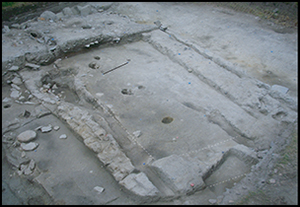
Figure 10. Agglomerated village plan showing mud buildings uncovered in test excavation 5: A) photograph; B) 3D scan.
Discussions
The spatial arrangements described above are far from those that would be expected for a Middle Neolithic settlement in Western Europe. Covered spaces on either side of partitionor earthen walls indicate a composite plan. This clearly differs from the model of a domestic structure, usually built on sunken posts, that makes up the plan of most Neolithic villages known in Western Europe; we are not dealing with a simple adaptation of locally known plans to different building materials. An alternative approach is to seek comparisons in contemporary architecture with a similar plan, built with comparable materials, but in more remote areas.Cob architecture is traditionally thought to be associated with Neolithic populations of south-east Europe, sometimes appearing as tells, as in Central Europe (e.g. Kovacevo; Brochier Reference Brochier1994) or in the Middle East, some of which were destroyed by fire (Chapman Reference Chapman, Gustafson and Karlsson1999; Stevanovic Reference Stevanovic and Gheorghiu2002; Lazăr et al. Reference Lazăr, Ignat, Stan, Moldoveanu and Radulescu2012). These types of remains, which form an anthropogenic hill, have not been encountered in continental and Western Europe. Other forms of earthen architecture are known in southern Europe, where they appear fairly frequently from the beginning of the fourth millennium BC, particularly in Spain.The discovery of Neolithic earthen architecture in France was at first thought peculiar. The discovery consisted of wall sections collapsed in ditch fills attributed to the Fontbouïsse group (third millennium BC) in the coastal plain of eastern Languedoc (Wattez Reference Wattez, Beeching and Sénépart2009). It came gradually to be understood that the elevations of these buildings were indeed preserved (Jallot Reference Jallot, Beeching and Sénépart2009). Other earthen walls had also been suspected further north, again from the third millennium BC, at Oisseau in Mayenne (Letterlé Reference Letterlé1986) and at Ponthezières on the île d’Oléron (Laporte Reference Laporte2009). New discoveries of this kind tend to be the result of rescue archaeology.
Archaeologists subsequently became aware of earthen architecture on earlier, Middle Neolithic sites, for instance, at Montpellier or Marseille in southern France (Beeching & Sénépart Reference Beeching and Sénépart2009). The northernmost examples were located in the Garonne valley, in the form of rampart remnants uncovered at the Château-Percin in Seilh, Haute-Garonne (De Chazelles et al. Reference de Chazelles, Pons and Gandelin2012). The evidence discovered at Lillemer belongs to this Middle Neolithic period. It testifies to the employment of cob or earthen construction, at least up to the shores of the English Channel. The composite plan is reminiscent of the site of Fossé in Central France (Despriée Reference Despriée1986), attributed to the fifth millennium BC Chambon group and containing amongst other things numerous oval-mouthed vessels.
The sequence at Lillemer is curious. It is clear that the plan, at least in essence, and the material used, are fairly close to those of entirely anthropogenic tells of south-east Europe. The situation at Lillemer, however, is different. The remains are directly sealed beneath the causewayed enclosure. Funerary monuments, particularly megalithic monuments, are sometimes built on the exact location of wooden buildings, and are very likely to seal the remains of the latter. Ian Hodder's (Reference Hodder, Jones, Pollard, Allen and Gardiner2012) recent discussion of the process of tell formation at sites such as Çatalhöyük in Turkey finds an echo here. He suggested that, as similar plans were applied to superimposed buildings over several generations, possibly by the same family group, these domestic units must have played an important role in the transmission of spatial memory. This role is, in Atlantic Europe, rather assumed to be played by stone funerary monuments, as though suspended for eternity. Here, the permanence or recurrence of space occupation, for settlements, eventually consists of horizontal, rather than vertical, accumulations.
Conclusions
The discovery of an entire village of composite earthen-walled buildings on the shores of the English Channel is astonishing, given our knowledge of the Western European Neolithic, particularly for the second half of the fifth millennium BC. The use of hand-shaped earthen brick at this site is incontrovertible, and earthen bricks have in fact been employed in modern buildings even farther north (Loveday Reference Loveday2006). At Lillemer the building plans still need to be uncovered more fully to reveal the site boundaries, variations through time, its relationship to the closest marshy areas and to understand the earthen buildings spread across the various terraces clinging to the flanks of the hill. At the moment, this remains an isolated discovery in the northern half of Western Europe. Comparisons with south-east Europe appear distant, while similar buildings from the Iberian Peninsula belong to a later period, at the end of the Neolithic. Nonetheless, rescue archaeology in northern France continues to uncover new evidence leading in the same direction. If these discoveries were to be found more frequently, what would the impact be on our interpretation of at least some of the causewayed enclosures? Many enclosures are distinguished by the absence of domestic structures, built on sunken posts, in the interior. Could the confirmation that mud architecture was much more widespread also trigger a revision of our understanding of the degree of mobility associated with these groups? This discovery at Lillemer opens up a new field of study and investigation, employing the most elementary methods yet with results fundamental to our discipline.


