


Introduction
Kale-Krševica is a Late Iron Age fortified hilltop settlement in south-eastern Serbia. Since 2001, excavations have uncovered the earliest occupation of the site—dated to the late fifth/early fourth century BC—with successive phases of domestic activity on the hilltop, enclosed by a dry-stone wall fortification that follows the outline of the plateau (the ‘acropolis’). The start of a second architectural phase, from the mid fourth century BC (Popović Reference Popović, Tasić and Grozdanov2006), or more probably the beginning of the third century BC (see below), was marked by the construction of large ashlar masonry and mud-brick ramparts that expand the fortified area at the foot of the hill (the ‘suburbium’). As with the sites of Pistiros, Bylazora, Helis, Seuthopolis and other contemporaneous inland settlements of Thrace and Paeonia (Figure 1), Kale-Krševica shares many aspects of its material culture, including ceramics and technologies, with settlements in ancient Macedonia and the northern Aegean, indicating intensive contact with the Greek world (Popović Reference Popović, Tasić and Grozdanov2006, Reference Popović and Cvjetičanin2012; Archibald Reference Archibald2013).

Figure 1. Map showing the most prominent pre-Roman ‘Hellenised settlements’ and relevant Greek cities, with an inset site-plan of Kale-Krševica (figure by A Subotić, A. Nikolić & I. Vranić).
While all of the scholarly explanations for the cultural and technological practices evidenced at these Balkan sites agreed on the central role of contact with the Greek world, they vary in the details of their interpretations. Some argue that the settlements were royal towns, built by local elites in imitation of Greek models and intended to convey cultural inheritance and social power in Thracian and Paeonian society (e.g. Stoyanov et al. Reference Stoyanov, Mihaylova, Nikov and Nikoleva2006; Mitrevski Reference Mitrevski2016). Others argue that they were Greek or Macedonian trading colonies or garrison towns occupied by Greek or Macedonian soldiers and settlers (e.g. Archibald Reference Archibald, Hansen and Nielsen2004), as well as various combinations of these models (Archibald Reference Archibald2013; Nankov Reference Nankov, Valeva, Nankov and Graninger2015). As such, all of these interpretations rely on a narrative of Hellenisation that assumes the superiority of Greece and the straightforward transmission of new material culture and ideas from the Greek world to local groups; for example, the social significance of material culture is assumed to have remained unchanged as it moved between Greece and the European hinterland (Vranić Reference Vranić, Janković, Mihajlović and Babić2014a & Reference Vranić, Popa and Stoddartb). Post-colonial critiques of Hellenocentric narratives have been developed in a number of Mediterranean regions (Gosden Reference Gosden2004; Dietler Reference Dietler2010); Kale-Krševica offers the potential to contribute to this scholarly enterprise from a South-eastern European perspective. The biographical approach presented here reinterprets the most prominent ‘Greek’ structure at Kale-Krševica: a barrel-vaulted water reservoir, discovered in 2008 (Popović & Vukadinović Reference Popović and Vukadinović2011; Popović Reference Popović and Cvjetičanin2012: 25–30), by scrutinising what is ‘Greek’ about this technology, and the context of its construction and life-history. The unusual and apparently unique use of a barrel-vaulted structure for the collection of groundwater adds to our knowledge of Early Hellenistic hydraulic technology in this region (see Lewis Reference Lewis and Wikander2000; Wilson Reference Wilson and Oleson2008)—the first-known reservoir of its kind from the continental Balkans.
The site represents an early but sophisticated use of a barrel-vaulted chamber, constructed using wedge-shaped ashlar blocks, or voussoirs, without mortar, making it a useful case study for discussion of theories of cultural and technological change. This very specific architectural form—probably invented no more than 50 years earlier by Macedonian military/royal engineers—formed part of a sophisticated water-supply system constructed at Kale-Krševica. Consideration of the context in which it was built and the social roles accumulated through its cultural biography can give insights into the nature of Greek-indigenous relations.
The barrel-vaulted reservoir at Kale-Krševica
Investigations in the ‘suburbium’ at the foot of the hill below the main settlement of Kale-Krševica have revealed an elaborate water-supply and fortification complex, including a barrel-vaulted reservoir measuring 9.68m long × 5.74m wide externally, and 9.48 × 5.26m internally; access to the chamber was facilitated by two symmetrically positioned rectangular openings through the barrel vault (Figures 2–3A).

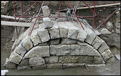
Figure 2. Left) photograph of the Kale-Krševica barrel-vaulted reservoir (and supporting scaffolding) taken during excavation and showing the extent of waterlogging; right) profile drawing (photograph by P. Popović & A. Djordjević; illustration by N. Lazarević).

Figure 3. Plan of the barrel-vault showing the different areas of the complex (A–H); the inset illustrates a theorised reconstruction of the reservoir's function (figure by N. Lazarević, A. Subotić & I. Vranić).
The reservoir sits within a large space (210m2) enclosed by two 2.8m-wide mud-brick and ashlar masonry ramparts (Figures 3B–C) and a 4.72m-wide platform (Figure 3D) on three of its sides; on the fourth side, the water-supply complex cuts into the soft sandstone hillside (Figure 3E). The 3m-high platform (Figure 3D), which divides the entire excavation area into southern (Figure 3A–C & E) and northern sectors, forms a terrace in the hillside. The platform's extant lower wall segments are merged from two ashlar walls cascading from the slope. Although the upper parts of the two walls have been robbed out, a ‘cleft’ survives by which water was conveyed onto the platform. Bonded with continuous ashlar masonry to the platform in the northern sector is a massive rectangular foundation (approximately 6 × 3m) with stone-rubble fill, and grooves and sockets on the upper surface (Figure 3F) that indicate the former presence of either a tower or, more probably, a mud-brick bastion built on a wooden framework. Two stone washbasin stands (louteria) (Figure 3G), discovered next to the location of the putative bastion (Figure 4), and a stone spout set in a partially excavated stone wall in the northern profile (Figure 3H), support the interpretation of the wider complex as a sophisticated hydraulic installation. All the ashlar blocks are of tuff quarried from a site approximately 10km from Kale-Krševica.

Figure 4. Photograph of two louteria (washbasin) stands, found in situ at Kale-Krševica (see Figure 3G) (photograph by P. Popović & A. Djordjević)
The complex was excavated between 2002 and 2011. Following the initial discoveries, the trench was repeatedly extended, eventually reaching almost 1100m2. Investigations were complicated by groundwater flowing from the direction of the hillside, which submerged the entire excavation trench and required constant pumping to facilitate work. Due to the growing expense of the operation and the risks associated with working at depths of 6m, excavations were stopped before reaching ‘natural’ soil. At this point, the entire complex was covered with sand for protection, and the excavators Popović and Vukadinović (Reference Popović and Vukadinović2011) published their preliminary report.
Stratigraphy and chronology
1) The stratigraphic sequence of the site reveals three broad levels: the simultaneous construction of both the fortification and the hydraulic complex (structures A–F), including a substantial quantity of material used to fill the space around the reservoir in order to ensure its stability. In addition to multiple layers of coarse sand and gravel, this fill also contained two layers of scattered ashlar blocks and unshaped stones at the level of the springers of the barrel vault; the latter of these two stone layers sealed a pottery assemblage (Figure 5).
2) An occupation level, above the barrel vault, with structures and features including the remains of stone walls forming rooms built against the (now lost) mud-brick ramparts, various postholes, dressed stone bases for round wooden posts and dozens of bread ovens and other pits (Figure 6).
3) Disturbed layers (approximately 2m in depth), rich in broken stone and mixed with various fourth-/third-century BC materials, presumably eroded from the slope above.

Figure 5. Left) later layer of subterranean ashlars and boulders sitting on top of the layer of broken pottery; right) row of ashlars on top of the vault's springers, which provide buttressing (photographs by P. Popović & A. Djordjević).

Figure 6. Left) plan of the reservoir, bread ovens, pits and surviving walls of structures added to the mud-brick ramparts; middle) excavation of pits and postholes; right) plan view photograph of a sectioned bread oven (plan by N. Lazarević, S. Živanović & I. Vranić; photographs by P. Popović & A. Djordjević).
Prior to the onset of the erosion down from the hillside above, the interior of the barrel-vaulted structure was deliberately filled with 4m of material, bringing an end to its use as a reservoir. Dozens of dressed stones, including the slabs that covered one of the two access points to the reservoir's vault, were found near the top of this fill. The reservoir also contained the skeletal remains of 10 horses, 20 dogs and the bones of a number of other species (Popović Reference Popović2008). Geological coring shows that the reservoir's full depth probably reached around 6m (Figure 7).

Figure 7. View of the reservoir interior (photograph by P. Popović & A. Djordjević).
The original construction of the hydraulic complex has been dated to “no later than the middle of the fourth century BC” (Popović & Vukadinović Reference Popović and Vukadinović2011: 166). This is based on the assumption that Kale-Krševica is Strabo's Damastion—an otherwise unlocated ‘Greek’ town in the Balkan interior (see Popović Reference Popović, Tasić and Grozdanov2006, Reference Popović and Cvjetičanin2012). As Damastion ceased issuing silver coins in the late 320s BC, Popović assumes that the construction of the most prominent ‘Greek’ structure at the site must therefore be of an earlier date, hence the suggestion of the mid fourth century BC.
Significant assumptions about the interpretation of the hydraulic complex also contribute to Popović’s date. Most importantly, he assumes that, in antiquity, the upper part of the barrel vault stood above ground level, and therefore that the two layers of unshaped stones and ashlar blocks found at the level of the springers must represent the remains of a separate and earlier structure. Moreover, as the imported wares associated with the second stratigraphic level located above the barrel vault include late fourth-/early third-century BC material, he assumes that this layer must post-date the construction of the mid fourth-century barrel vault, indicating a change in the primary function of the complex, possibly due to a rise in the water table. In contrast, however, it is argued here that all of the features of the first two stratigraphic levels are effectively contemporaneous. The presence of the unshaped stones and ashlar blocks found at the level of the springers suggests that the barrel-vault was originally built entirely underground. The most important technical function of any barrel vault is the ability to transfer the massive weight of the roof, and anything above it, down through the springers and walls into the ground. In this case, it is argued that the position of the ashlar blocks is at exactly the level where buttressing would be necessary if the vault was originally entirely subterranean (cf. Tomlinson Reference Tomlinson1987: 308). This supports the contention of a single construction phase, without the need to assume the existence of any earlier structures. Moreover, a bronze coin minted c. 300 BC by Alexarchus in Uranopolis and found near the bottom of a 1.45m-deep pit (see Mitrović & Popović Reference Mitrović and Popović2009), which in turn was cut into the sandstone hillside and sealed beneath the second stratigraphic layer with postholes and bread ovens, provides a terminus post quem for the construction of the whole complex.
Construction phase: architecture, hydraulic technology and function
The excavators Popović and Vukadinović (Reference Popović and Vukadinović2011) argue that the hydraulic complex consisted of a ‘collector basin’—the space defined by the platform (D), the ramparts (B–C), and the slope (E)—and a ‘capture’, that is—the barrel-vaulted reservoir (A), in the lowest section of the system, where the water was collected. The collector basin tapped a subterranean aquifer, and the layers of sand and gravel around the reservoir allowed water to seep in through the porous tuff vault and walls. Part of the southern rampart (C) curves slightly towards the centre of the basin (Figure 8) in order to withstand the enormous pressure of the water within, while the slits discovered on the rampart (C) allowed the excess water to exit the system. A complete understanding of the hydraulic technology used here is lacking, as the excavations did not reach the lowest levels of the reservoir. By considering the cultural biography of the complex, however, it is possible to offer some alternative reconstructions.

Figure 8. View of the southern curved rampart (see Figure 3C) with the water-exiting slits (photograph by P. Popović & A. Djordjević).
The ashlar walls of the underground capture bear no traces of waterproof plaster—a common feature associated with cisterns in antiquity. Unless the lower unexcavated sections were plastered, it seems that the structure was designed to be porous, allowing water filtration. One of the access points through the barrel vault—in addition to some dovetail clamps fixed in lead—provides indications of the use of buckets on ropes, in the form of a deep groove in the stonework (Figure 9). The purpose of the ramparts and the platform forming the basin may have been to collect groundwater percolating through layers of gravel and coarse sand that comprise the natural geology between the foothills and the nearby Krševička Reka River. Another equally important function may have been to prevent the mixing of river water with the seemingly more desirable aquifer water. If this reconstruction is correct, the slits on this rampart (C) allowed excess water to flow out from the system, thereby maintaining a balanced water level. The most significant remaining questions regarding the operation of the reservoir concern the uncertainty about the level of the water table in antiquity. Today, the level is about 1m above the top of the barrel vault, indicating a substantial rise since antiquity and complicating our understanding of the original operation of the system.

Figure 9. One of the two access openings, with the dovetail clamps surrounded by lead, and a rope-wear groove on the far side of the opening (photograph by P. Popović & A. Djordjević).
An important question relative to the reconstructed function posited above is that of whether or not the aquifer was the only source of water. Specifically, this matter impinges upon our understanding of the funnel-like cleft that channelled water onto the platform, and the stone spout in the northern trench profile where the two louteria stands were discovered. At present, the function of this partly excavated spout remains unknown. Its stratigraphic position indicates that it related to water from the same level as the cleft, as the two are both located approximately 1.7m above the top of the reservoir and around 3m above the slits of the southern rampart. The funnel-like cleft perhaps suggests that a spring once existed on the slope and that the wall ends forming the platform represent an undiscovered and probably collapsed artificial outlet of the same aquifer from a higher elevation. This configuration may have provided a permanent flow of water channelled by the two robbed-out walls onto the platform, and from there, via the slits, on the northern ashlar face of the platform and into the northern section, while the southern section with the reservoir was designed for groundwater only. It is also possible that the funnel-like cleft simply collected rainwater and channelled this onto the platform. Either way, the slits, which are only found on the northern ashlar face of the platform, prevented the mixing of water destined for the northern section with the groundwater in the southern one.
Small-scale geophysical surveys conducted following the excavations show that the slope and the entire surrounding area has abundant groundwater. They also indicate that two massive structures were located on either side of the excavated area, one not far from the putative tower (F) to the north-east, and the other to the south, probably joining with the southern rampart (C).
Who were the architects?
The question of when the barrel-vault and voussoir construction techniques first emerged in the Greek world—and therefore the potential date of the Kale-Krševica complex—remains controversial. Central to the debate is the issue of the burial of Philip II, Macedonian king from 359–336 BC and father of Alexander III (‘the Great’) (Hatzopoulos Reference Hatzopoulos2008). One group of scholars accept Andronikos's (Reference Andronikos1989: 97–197) interpretation of Tomb II within the Great Tumulus at Aigai (Vergina) as the location of the king's burial in 336 BC; if correct, the two chambers in this tomb would represent the earliest-known ashlar masonry barrel vaults (Tomlinson Reference Tomlinson1987: 311; Chilidis Reference Chilidis2007: 79–84). Others scholars, however, follow Boyd's (Reference Boyd1978) argument that this architectural technology emerged following Alexander III's later conquest of Asia Minor; Macedonian military engineers encountered the local mud-brick arches and copied the design in stone (e.g. Borza & Palagia Reference Borza and Palagia2007).
As there is no indication that the structure at Kale-Krševica was a burial chamber, the origins of non-funerary barrel-vaulted structures becomes a question of importance. Dating to after the Battle of Chaeronea in 338 BC, and before 320 BC, the oldest and most conclusive examples of this architecture are the tunnel entrances at the stadia of Olympia and Nemea respectively (Miller Reference Miller2001: 92). Subsequently, they became common in theatre passageways, such as at Eretria, Sikyon and Magnesia (cf. Boyd Reference Boyd1978: 84; Winter Reference Winter2006: 110); in city gates, as at Corinth and Samos (cf. Boyd Reference Boyd1978: 83–84 & 87; Tomlinson Reference Tomlinson1987); and in public granaries and arsenals (Winter Reference Winter2006: 151–54) that emerged at various Early Hellenistic-period centres with direct connections to high-ranking Macedonian military and royal activities (Boyd Reference Boyd1978: 88–90). Regarding the hydraulic technology utilised for the vault, there are two reservoirs within the gymnasium fountain house at Sikyon, dated to shortly after 303 BC, when King Demetrius (I) Poliorcetes of Macedon (294–288 BC) relocated this city (Boyd Reference Boyd1978: 84, fig. 1). Yet subsequent studies have placed its construction in the second century BC (e.g. Lolos Reference Lolos and Des Courtils2015: 66 & 71). The tunnel beneath the Ptolemaion built by Ptolemy II (king of Egypt 283–246 BC) in Samothrace from the second decade of the third century BC (Boyd Reference Boyd1978: 84–88, fig. 3) gives a securely dated precedent for the diversion of a stream to allow the construction of a monumental entrance (Wescoat Reference Wescoat and Miles2016: 430).
Despite the uses of barrel vaults for these hydraulic schemes, however, their functions are different to those of the reservoir at Kale-Krševica. Accepting the aforementioned reconstruction of the reservoir as a groundwater catchment providing filtration, the Kale-Krševica hydraulic installation is unique. Its construction c. 300 BC probably makes it the oldest-known barrel-vaulted chamber used in a water-management complex. The two openings through the vault, which interrupt the rows of keystones crucial to the barrel vault's stability, add another unique aspect, while its dimensions (49.86m2) make it almost exactly 2.5 times larger than the main chamber within Tomb II at Vergina (cf. Borza Reference Borza1987: 121). Whether the masons responsible for the construction were part of the Macedonian military, or whether they represent local craftspeople who had acquired Macedonian technical knowledge, remains unclear.
Water-consumption practices
Why might such an elaborate water-management system have been required? The second stratigraphic layer, located above the reservoir and featuring postholes, stone walls and ovens, provides evidence for large-scale food production—presumably using the abundance of available water. This layer included dozens of ‘Olynthus’-type grain mills, mostly fragmented, but also a few rotary mills, a large quantity of carbonised einkorn and barley in one of the pits (Medović Reference Medovićin press), and numerous zooarchaeological finds, of which the latter await analysis. The Olynthus ‘hopper rubber’ handmills at Kale-Krševica were probably produced from locally quarried basalt (Popović & Kapuran Reference Popović and Kapuran2007: 88). First appearing in the Classical period, they are common throughout the Greek colonies of the Mediterranean, but also at other centres where it is thought that they were “defused primarily by Greek settlers” (Frankel Reference Frankel2003: 1). Conversely, the rotary mills are highly unusual in pre-Roman contexts, and therefore require further scrutiny. Other artefacts from the second stratigraphic layer associated with food production include stone mortars with spouts and marble pestles. There are also Hellenised Grey Ware vessels for food production (chytrai, lekanides, shallow pans, and wheel-thrown or handmade cooking jars), although analysis reveals that the majority of the Grey Wares are for consumption and storage (e.g. skyphoi, kantharoi, echinus-type bowls, hydriai, oinochoai and pithoi). There are approximately 15 000 ceramic sherds from contexts in the northern and southern sectors related to use of the reservoir, while the entire ‘suburbium’ complex has produced 78 355 fragments.
Imported pottery from the second stratigraphic level includes vessels from Attic and Northern Aegean workshops active after the disappearance of red-figured ware, but before the appearance of true West Slope ware (dating to between the end of the fourth century and the beginning of the second quarter of the third century BC) (cf. Rotroff Reference Rotroff1997: 40–43). The most common imported forms are kantharoi, or drinking cups. Alongside large-scale food production, these finds indicate wine consumption, further supported by the recovery of numerous—although rarely stamped—transport amphorae. The second stratigraphic level has also yielded artefacts pertaining to other activities, including a large number of loom weights. So far, excavations at Kale-Krševica have recovered around 2000 loom weights, including pyramid-shaped, fiddle-shaped and discoid forms (Popović & Vranić Reference Popović and Vranić2008), while the layers associated with the use of the reservoir have yielded several hundred other artefact types (Figure 10).

Figure 10. Some of the contemporaneous artefacts found in association with the reservoir (photographs by N. Borić).
The social life of the barrel-vaulted reservoir
Does the construction of the reservoir and its possible role in large-scale food production provide sufficient evidence for an inland Macedonian garrison town? Literary sources document Cassander's aggressive policy towards the Balkan hinterland and his practice of establishing garrisons through military action and alliances with local groups (e.g. Adams Reference Adams, Roisman and Worthington2010: 215; Emilov Reference Emilov, Valeva, Nankov and Graninger2015: 369). If Early Hellenistic-period, non-funerary, barrel-vaulted structures are indeed exclusively related to the Macedonian army (sensu Boyd Reference Boyd1978: 88–90), then the structure at Kale-Krševica could represent evidence of Macedonian military expansion. In such a context, the second stratigraphic level, with its Greek-type grain mills and other cooking paraphernalia, may represent a facility for the provision of food and water for a large number of soldiers. Bronze coins of Macedonian kings, commonly found at other settlements across this region (e.g. Seuthopolis) and interpreted as the soldiers’ “daily stipend for meals” (Paunov Reference Paunov, Valeva, Nankov and Graninger2015: 270), may also support this hypothesis (cf. Nankov Reference Nankov and Aygün2009).
Arguably, however, interpretations such as these tend to overestimate the possibility of a Greek presence, emphasising colonial and ‘Hellenocentric’ perspectives that neglect local agency. Some, for example, take epigraphical evidence, such as the Pistiros inscription, as proof of the existence of inland emporia—possibly even true poleis—settled in the fifth century BC during Greek migrations into the interior (e.g. Archibald Reference Archibald, Hansen and Nielsen2004; contra Tsetskhladze Reference Tsetskhladze2011). Supplemented by Philip II's later conquest of continental Thrace in 342–340 BC, scholars who advocate this position tend to emphasise the direct role of Greece/Macedonia in the urbanisation process through the establishment of garrison towns and colonies (e.g. Philippopolis, Kabyle, Heraclea Sintica, Alexandropolis), exercising a “policing function” (Archibald Reference Archibald1998: 305) and introducing the first “civic institutions” (cf. Archibald Reference Archibald, Hansen and Nielsen2004: 889; Loukopoulou Reference Loukopoulou and Lane Fox2011: 468). Proponents of this model often focus on ‘finding the Greeks’ at the most prominent sites in the hinterland, reinforcing a strong—although probably inaccurate—dichotomy between Greek and non-Greek that was not meaningful in the past.
Realising some of these pitfalls, most contemporary researchers perceive these inland garrison towns and colonies as settlements with mixed populations (e.g. Nankov Reference Nankov, Valeva, Nankov and Graninger2015: 402–403). Yet this interpretation has hitherto only been used as a blanket-term, conceived to deal with the shortcoming of ethnic determinism inherent within Hellenisation and the overall similarity of material culture across vast areas. Even if the reservoir's construction did result from Cassander's practice of establishing garrisons, this does not necessarily represent a unilateral imposition of colonial power; the ‘suburbium’ at Kale-Krševica was an addition to the already thriving ‘Hellenised’ community that had inhabited the ‘acropolis’ from the late fifth century BC. Even if the construction phase was driven by Macedonian imperialism through the presence of a garrison, it also represents a complex encounter with social groups already familiar with the Greek world. The materiality of the reservoir had potential both to shape and reflect local social identities via the complex interaction, including cooperation, between the Macedonian military and the local agents.
There are also other possible agents who were capable of constructing the reservoir: local men returning from service with Alexander III or in other Early Hellenistic armies (cf. Nankov Reference Nankov and Manov2011). Through service as heavy cavalry or light infantry, these men could have become acquainted not only with the broader “matrix of [Macedonian] warrior society” (Millett Reference Millett, Roisman and Worthington2010: 475 & 492), but also with the concept of barrel-vaulting. This technological knowledge, which could have been directly acquired during their service or, more probably, subsequently provided via contracted masons, may have been actively selected, not in simple imitation, but as an answer to specific local hydraulic problems. If this was the case, the unique installation cannot be assumed to be a Greek innovation without known appropriate parallels in ancient Greece. Consequently, the water-supply and fortification system at Kale-Krševica may be perceived similarly to the ‘Hippodamian’ street layout and fortification at Seuthopolis (Nankov Reference Nankov2008): that is, as a re-contextualised appropriation of Macedonian military architecture, instigated by retired local warriors in order to construct and maintain their own social and cultural identities through the local production and consumption of ‘Greek’ materiality (cf. Nankov Reference Nankov, Valeva, Nankov and Graninger2015: 405). In this scenario, the large-scale food production attested at Kale-Krševica would therefore not relate to the provisioning of soldiers; one could hypothesise some sort of collective feasting as an alternative, while the loom weights may represent a local practice of weaving that took place in both domestic and public spaces.
Yet, deciding between the two possible explanations outlined above for the construction of the reservoir still represents an over-simplification of what, in reality, was almost certainly a highly complex social and material entanglement in the Balkan hinterland of the Hellenistic world (cf. Archibald Reference Archibald2013). This is a theme often neglected in the global archaeological literature, which generally fails to go beyond a dichotomy between Greek and indigenous agency. Rather than trying to find evidence for the presence of Greeks, in pursuit of a more ‘valuable’ form of heritage, future research in this region should focus on identifying insights into the elusive local responses to Early Hellenistic-period Macedonian imperialism (cf. Vranić Reference Vranić2012: 40–42).
The end of the reservoir's biography, marked by the deliberate infilling of the chamber with rubble, along with the skeletons of 10 horses and 20 dogs, remains a mystery. The lack of true West Slope pottery in the second stratigraphic layer could suggest that the turmoil of the early third century BC, traditionally characterised as a result of ‘Celtic raids’ (cf. Dzino Reference Dzino2007), interrupted most of the north–south networks that spanned the region. Yet, a lack of Attic pottery cannot, in and of itself, be considered a reliable indicator of chronology (see Stolba & Hannestad Reference Stolba and Hannestad2005). Scholarly assumptions about the end of the reservoir's use-life form part of an equally problematic culture-historical narrative. As with the Hellenisation explanation for the construction of the reservoir, understanding of its subsequent use and abandonment will require not only further excavation, but also new ways of conceptualising social and cultural change beyond the simplified and reductive ‘Celtic raids’ scenario.
Acknowledgements
I would like to thank the referees for remarks that helped to improve the structure of the paper, and Staša Babić and Vladimir Mihajlović for valuable comments on earlier drafts. This paper derives from the project ‘Serbian Archaeology: Cultural Identity, Integration Factors, Technological Processes and the Role of the Central Balkans in the Development of European Prehistory’ (OI177020), financed by the Serbian Ministry of Education and Science.


