


Introduction
The pre-Columbian Maya, like many other civilisations of the ancient world, flourished in an area highly dependent on access to water sources or water-related features. During the rainy season, the excess of water must have been channelled out of the Maya cities or architectural complexes to avoid flooding. Meanwhile, in dry seasons people might have suffered due to the lack of rain if water had not been stored previously in special reservoirs constructed by the Maya. The control of water was a crucial issue in the life of every Maya community. The Maya constructed special water-related features that had practical functions and were also used to strengthen the power of local lords who could boast responsibility for providing this precious liquid to the masses.
Over the past seven years, the Maya site of Nakum (located in north-eastern Guatemala; Figure 1) has been the subject of investigations conducted by the Nakum Archaeological Project of the Jagiellonian University, Kraków, Poland (see Źrałka et al. Reference Źrałka, Koszkul, Martin and Hermes2011, Reference Źrałka, Koszkul and Hermes2012; Koszkul & Źrałka Reference Koszkul and Źrałka2013). Recently, a very complex and sophisticated drain of Early Classic date (c. third–sixth centuries AD) was discovered in Structure 14—an extensively excavated construction situated in the southern sector of Nakum. The drain might have had a dual ritualistic and utilitarian function. It is exceptional in its form and proportions, and its discovery contributes to our knowledge of pre-Columbian water management. Herein, we highlight some similarities as well as the unique characteristics of the drain at Nakum Structure 14 and compare the systems used for water control at Nakum and other Maya sites. Our paper provides new data concerning the problem of water management in ancient societies and highlights the bifurcated nature of this process in the ritual and daily life of the ancient Maya.

Figure 1. Map of north-east Guatemala showing the location of Nakum and neighbouring sites (map courtesy of Precolumbia Mesoweb Press).
The Nakum site
Nakum consists of two separate architectural sectors (northern and southern) located on two low natural hills in the close vicinity of the Holmul River. Both sectors are connected by an elevated causeway (the Périgny Causeway), which is approximately 250m long × 26m wide. Nakum has been known to scientists for more than 100 years. It was discovered in 1905 by the French count Maurice de Périgny (Reference de Périgny1908, Reference de Périgny1911). Later, the site was visited and cursorily investigated by Alfred Tozzer and Raymond Merwin from the Peabody Museum of Harvard University (Tozzer Reference Tozzer1913), followed by Sylvanus Morley (Reference Morley1937–1938) from the Carnegie Institution of Washington. The ruins were forgotten in the ensuing decades until they were visited twice in the 1970s by Nicholas Hellmuth, who made corrections to the existing map (Hellmuth Reference Hellmuth1975, Reference Hellmuth1992). It was, however, only in 1994 that Nakum was subjected to close scrutiny by the Triángulo Project of the Guatemalan Institute of Anthropology and History (IDAEH). As a result of this research, the centre and periphery of the site have been studied in detail, with many structures excavated and subsequently restored (Quintana & Wurster Reference Quintana and Wurster2002; Calderón et al. Reference Calderón, Matute and Bazy2006). In 2006, thanks to permission from IDAEH, a new archaeological project was undertaken at Nakum by the Jagiellonian University (the Nakum Archaeological Project).
Structure 14 and its architectural evolution
For a better understanding of the significance of the newly discovered drain at Nakum, we first present the architectural history of Structure 14. It is situated in the northern part of the Acropolis, which is the largest and most impressive complex at the site (Figure 2). The Acropolis consists of a platform surmounted by more than 30 structures, mainly palace residences, surrounding 12 patios or courtyards (Quintana & Wurster Reference Quintana and Wurster2002; Tobar & González Reference Tobar, González, Laporte, Arroyo and Mejía2007; Źrałka et al. Reference Źrałka, Koszkul, Martin and Hermes2011). The largest of these is Patio 1. Structure 14, along with its neighbour Structure 15, demarcate Patio 1 from the east. It is now c. 10m high and is almost completely covered by jungle. Excavations carried out between 2007 and 2012 at Structure 14 revealed that this mound-like construction covers vestiges of several older buildings that have been successively rebuilt between the Protoclassic and Late Classic periods (first century BC–AD 800).

Figure 2. Map of the Acropolis complex at Nakum showing the location of Structure 14 and the water drain discovered in the area of this construction. The blue arrow indicates the possible direction in which the drain continues (map: DECORSIAP, IDAEH with corrections made by the authors).
Our work showed that the first version of Structure 14 was a platform 2m high with a 15m-long stairway on its main western façade, leading to the level of Patio 1 (stage 14 Sub-1; see Figure 3a). The stairway was flanked on both sides by stucco masks, which unfortunately were documented in a poor state of preservation. This construction was most probably built during the Protoclassic phase (c. 100/50 BC–AD 250/300), and it also underwent several remodelling programmes during this period (Figure 3b–e). At the northern end of Structure 14, a building named the Friezes Building (Edificio de los Frisos) was constructed during one such rebuilding programme, dating to the final part of the Protoclassic (Figure 3e). The western side of its base platform was embellished with a rare stucco frieze that was only partly preserved and that represented two individuals, probably Maya gods called the Hero Twins, flanking a large, central zoomorphic creature or deity (Figure 4).

Figure 3. Reconstructions of the major architectural stages of Nakum Structures 14 and 15 (by Breitner González and Telma Tobar, based on drawings by Wiesław Koszkul, Nakum Archaeological Project).

Figure 4. Nakum Structure 14: a) western façade of the Friezes Building with location of the frieze; b) image showing two important architectural stages of Structure 14: the red colour illustrates the western façade of the Friezes Building, the blue colour shows an outline of the Hidden Building that covered the frieze during one of the remodellings; c) fragment of the frieze from the Friezes Building (drawing by Katarzyna Radnicka and Wiesław Koszkul; photograph by Jarosław Źrałka).
In the Early Classic (c. third–fifth centuries AD), the platform of Structure 14 was enlarged to the west, in the direction of Patio 1, and a new building (the Red Building or Edificio Rojo) was erected on it (Figure 3f). It had two major interconnected rooms and an entrance from the south. This rebuilding process brought about a significant change as it closed the visual access to the frieze from the Patio 1 courtyard. Later, other important changes were introduced. The Red Building was encircled from the west and north-west by a high wall with a sophisticated drain located in its upper part (Figure 3g). Around the same time, in a small space between the Red Building and the Friezes Building, a small, one-chambered construction named the Hidden Building (Edificio Escondido) was created. Moreover, during this remodelling, the upper part of the frieze was razed while its lower part was sealed and covered by the floor of the newly constructed Hidden Building (Figure 4b).
At the end of the Early Classic or beginning of the Late Classic (sixth, or beginning of the seventh, century AD), another construction was built to the south-east of the Red Building. Dubbed the Building of the Columns (Edificio de las Columnas), it had a row of masonry columns on its façade orientated to the east (Figure 3h). However, at the beginning of the Late Classic period (or at the onset of the seventh century AD), all of the aforementioned structures were sealed and covered by a large pyramid (denominated as phase 14–1; see Figure 3i). The latter construction never had masonry superstructures, which were a feature common to most neighbouring buildings. Instead, we identified vestiges of low platforms that, most probably, served as the bases for perishable superstructures that once stood on top of the pyramid. Pyramid 14–1 was rebuilt several times during the Late Classic period (seventh–eighth centuries AD; see Figure 3j). The enlargements of Structure 14 in the Late Classic period must have been accompanied by ceremonies involving ritual destruction and the scattering of several polychrome vessels that were placed in the construction fill of the pyramid (see Figure 5). Structure 14 was also intensively used during the Terminal Classic (c. ninth–tenth centuries AD). Middens dating to the latter period and containing ceramic sherds, ash, bone artefacts and many other objects were found at the base as well as on the terraces of Structure 14.

Figure 5. Polychrome vessels found in the construction fill of Structure 14–1, dated to the first quarter of the seventh century AD (photographs: Robert Słaboński; ‘b’ prepared by Christophe Helmke, the hieroglyphic text from vessel ‘b’ contains part of a royal name, possibly of a previously unknown local lord).
The drain construction
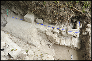
All of the archaeological data indicate that the drain built to the west and north-west of the Red Building was constructed in the Early Classic period (Figure 6). It was used for some time and was then partially destroyed and covered by new, Late Classic versions of Structure 14 and the neighbouring palace construction (Structure 13), as well as by a large complex of the Central Acropolis (Figure 2). The drain started somewhere on the second terrace of Structure 15; from there it went 6m in a westerly direction (Figures 6 & 7). In this section, the gutter is situated directly on top of the wall and is formed of U-shaped stone blocks (Figure 7). Subsequently, 6m to the west of the point where it starts, the gutter turns 90° to the south and continues another 6m on the upper interior part of the wall (which is 2.7m high) till it protrudes through a small opening in the exterior part of the wall (Figure 8). Subsequently, it descends to the level of the platform through a trapezoidal masonry element attached to the wall (see Figures 6, 8 & 9). The gutter then continues on the platform on which the Red Building stands in a southerly direction (Figure 10), disappearing below the so-called Structure 13. The latter construction post-dates and completely covers the gutter. However, our recent investigations indicated that the whole water feature is still well preserved below it, and that it proceeds towards the enormous platform of the Central Acropolis, below which it may continue for several metres more (see Figure 2). The end point of the drain remains unknown. We can speculate that it might have fed the neighbouring aguada (a natural or human-constructed pond) or another artificial reservoir constructed in the area of the Acropolis or outside of it.

Figure 6. Reconstruction view of Structures 14 and 15 at the moment of construction of a drain and the Hidden Building. Blue arrows mark the point where the drain starts (by Breitner González and Telma Tobar, based on drawings by Wiesław Koszkul, Nakum Archaeological Project).

Figure 7. The initial section of the drain where it first runs in an E–W direction and then turns 90° to the south; a) view from the north, blue arrows mark the direction of the flow of a gutter, the red arrow indicates the place where the drain starts and where a cistern might have existed (this part was destroyed during remodelling that took place in subsequent periods); b) view from the west of the same fragment of the drain; c) cross-section and plan of the initial section of the drain; note the wall supporting the drain (photographs: Robert Słaboński and Wiesław Koszkul, drawings: Dorota Polak and Beata Golińska).

Figure 8. a) Drawing showing the face of a wall that supports the drain and the trapezoidal feature attached to it; b) E–W cross-section of the same wall with drain that also features two major architectural stages: stage 1 is related to the period when the Red Building was constructed on the basal platform; stage 2 marks the phase when the wall with the drain was built and a corridor (pasillo) between it and the Red Building was formed, leading to the secret chamber of the Hidden Building (drawing: Katarzyna Radnicka).

Figure 9. Trapezoidal element attached to the wall with the drain—a possible replica of a sacred mountain (note the opening on the exterior of the wall through which water comes). Located in the lower part of the wall and marked with an arrow is the aperture that served to drain the passageway located behind the wall (photographs: Wiesław Koszkul and Robert Słaboński).

Figure 10. Medial section of the drain, running to the south of the trapezoidal element that symbolises the sacred mountain (marked with a red arrow) (photograph: Wiesław Koszkul).
It is important to mention that the initial section of the drain system (located close to the Red Building) was situated on the upper part of a wall whose face resembled a genuine, vaulted building façade. Thus, people standing on the neighbouring Patio 1 would have had the impression that the water (passing through a small opening in the wall in the place where it connects with a trapezoidal masonry element) was flowing from the interior of the building. Moreover, by erecting the specified wall slightly to the north-west and west of the Red Building, the Maya builders fashioned a secret passageway (pasillo) leading to the Hidden Building, and succeeded in completely hiding both the Red Building and the Hidden Building from Patio 1 (Figure 11a). It has to be highlighted in this context that while access to the Red Building was still possible from the wide courtyard nearby (Patio 9), the entrance to the Hidden Building was almost completely blocked. This observation obviously raises the question of the intention of this architectonical layout. Unfortunately, our investigations revealed that the Hidden Building had already been looted in pre-Columbian times. The architectural form and shape of this construction is exceptional. It is a one-chamber building 5m long (N–S), and between 1.00m and 1.25m wide (E–W), revealing a bottle-like cross-section (Figure 11b). The doorway leading to its interior chamber (which is between 1.3m and 1.4m from the floor to the vault spring) is very low and only 1.4m high. Moreover, the discovery of three hinge-like masonry elements indicates that the doorway might have been blocked from the interior. On the basis of the diminutive size and secret location of this construction, as well as the documentation of human teeth and carbon remains on its floor, we argue that the Hidden Building might have served as a temporary tomb or elite funerary shrine, where the bodies of the elite were temporarily stored before they were finally buried in graves (for comparable provisional tombs see Chase & Chase Reference Chase, Chase and Cobos2004). However, as we will show, the Hidden Building might also have had a deeper symbolism related to the sacred landscape and the underworld.

Figure 11. a) Plan of all buildings found below the Structure 14 mound (drawing: Aleksander Danecki and Wiesław Koszkul); b) interior of the Hidden Building; note the diminutive size of the chamber and of a doorway that is only 1.4m high; arrows mark three hinges used to block the entrance to the room (photograph: Wiesław Koszkul).
Sacred mountain and the cult of water
Of special importance is the presence of a trapezoidal masonry feature that was part of the drain system of Structure 14. This feature was covered with stucco and painted red (Figures 6 & 9). The unusual shape and exact function of this trapezoidal element has been debated since its discovery. However, it is highly probable that this feature might have been a man-made replica of a sacred mountain (Nikolai Grube pers. comm. 2010). According to the alternative hypothesis, the trapezoidal element might have invoked a mountain that was peculiar to this location (Nakum or its surroundings). Mountains played an extremely important role in the belief system of Mesoamerica in pre-Columbian, as well as modern, times. Scholars distinguish various types of sacred mountains in Mesoamerican mythology, such as water mountains, flower mountains, snake mountains or sustenance mountains (Schele & Guernsey Kappelman Reference Schele, Kappelman, Koontz, Reese-Taylor and Headrick2001; Taube Reference Taube2004). Although they bear different names in scientific discourse, these mountains represent and symbolise in most cases a sacred, blissful location, imbued with supernatural powers; a place where, according to Mesoamerican beliefs, the first people originated. The sacred mountain was also the source of water and maize, as well as the realm of ancestors and deities. It was the archetype of sustenance and a synonym for paradise, in addition to being the location associated with creation and foundation (see Miller & Taube Reference Miller and Taube1993: 119–20; Stone Reference Stone1995: 21–32; Graulich Reference Graulich1997: 115; Schele & Guernsey Kappelman Reference Schele, Kappelman, Koontz, Reese-Taylor and Headrick2001; Taube Reference Taube2004; Stone & Zender Reference Stone and Zender2011: 138–39). Popol Vuh, the sacred book of the Maya from the sixteenth century, names this mountain Paxil and recounts that it was filled with maize, from which people were formed (Christenson Reference Christenson2003: 193–94). Among the Aztecs this mythical place was called Tonacatepetl—the mountain from which the great god and cultural hero, Quetzalcoatl, brought the first maize and formed the first people (Christenson Reference Christenson2003: 193). We know that, for the Maya, pyramids were symbols of sacred mountains; buildings were in many cases embellished with representations of witz monsters (witz means ‘hill’ or ‘mountain’ in the Mayan language)—zoomorphic portrayals of mountains, signalling the sacred status of such structures. These mountain monsters were usually formed of stucco or stone, and they occupied façades of buildings, usually flanking stairways so that every person entering the structure could see them. Masks would feature mountains as living, animated entities. Sometimes they were accompanied by vegetation (especially maize) and water elements (Figure 12b–d). All these features would serve to mark mountains as sources of food and water. Mountain monster masks could also stand on or emerge from water symbols to indicate that they were floating in the primordial waters of creation (Figure 12c; Freidel et al. Reference Freidel, Schele and Parker1993: 138–40; Schele & Guernsey Kappelman Reference Schele, Kappelman, Koontz, Reese-Taylor and Headrick2001: 39).

Figure 12. Depictions of sacred mountains in Mesoamerican art: a) Teotihuacan, Tepantitla complex (note water coming out of the mountain); b–d) mountain monster masks embellishing façades of various Maya pyramids or temple-mountains (note vegetal elements shown in the upper parts of the masks): b) Uaxactun, Str. E-VII-Sub; c) Uaxactun, Str. H-X-Sub 3; d) Tikal, Str. 5D-33–2 (all redrawn by Piotr Kołodziejczyk, ‘a’ after Stone Reference Stone1995: fig. 3–18; ‘b–d’ after Schele & Guernsey Kappelman 2001: figs. 2.10, 2.11 & 2.14).
We argue that the drain system discovered in Structure 14 had both practical and ritualistic functions. The sophisticated shape of the northern section of the drain (which has a possiblereplica of a sacred mountain), as well as its complex planning, indicates that it was not used merely to drain water from the terraces of neighbouring Structure 15, where it originates. We think that an exclusively functional purpose cannot be ascribed to this construction, as the Maya could have used more efficient and less expensive ways of draining rainwater from Structure 15, such as the appropriately graded declining of terraces and floors or simple superficial stucco gutters. They did not need to build a wall that was almost 3m high for this purpose. The overall form of the shallow, narrow channel funnelled into the trapezoidal feature indicates that it must have been used mainly for a laminar flow of water (where the current of water is controlled to avoid its excess and overflow of the whole feature) and for aesthetic purposes (Terry Lustig pers. comm. 2014). Moreover, the open space that existed on the second terrace, between the temple of Structure 15 and the neighbouring Red Building, indicates that there might have been an unknown construction connected with the gutter, possibly some kind of cistern that might have been destroyed during one of the later remodellings.On the other hand, the wall with the gutter had several openings at its base that could drain water outside of the so-called pasillo (located between the Red Building and the wall itself). In the southern part of that wall, through one such opening, rainwater was drained from Patio 9 (which is located to the south of the Red Building), directly to the gutter running to the south of the previously described trapezoidal feature (Figure 9a). We therefore have confirmation of the practical use of the southern part of the water construction from Structure 14, discussed above. When the Building of the Columns was erected it blocked the pasillo, but the drain from Patio 9 was retained and embedded in the basal platform on which this building stood. Nevertheless, some time later, when the level of Patio 9 was raised and re-plastered, the aforementioned drain from the Building of the Columns was sealed and water from Patio 9 was channelled in another direction.
Utilitarian canals
The drain of Structure 14 differs significantly from a more functional canal that was discovered in the western part of the Acropolis complex during previous IDAEH excavations directed by Vilma Fialko and Zoila Calderón (Calderón et al. Reference Calderón, Matute and Bazy2006). It drained the large Patio 1 and its surroundings during periods of heavy rain. It starts in the south-western corner of Patio 1, from where it runs in a south-westerly direction, passing below Patio 4. The canal ended between Structures M and L, on the western wall of the Acropolis complex, where it discharged into the neighbouring aguada (see Figure 13). During rainy seasons the Nakum aguada would increase in size severalfold, catching an enormous amount of water that might have been used for months, especially during the dry season when precipitation was very low. The importance of this feature may be indicated by the discovery, during previous IDAEH research, of many constructions distributed along the eastern side of the aguada, including a shrine that might have been used during rituals of a water cult (see Calderón et al. Reference Calderón, Matute and Bazy2006; Koszkul & Źrałka Reference Koszkul and Źrałka2013).

Figure 13. a) Reconstruction of a subterranean canal leading from Patio 1 below Patio 4, out to the western façade of the Acropolis complex, where it discharged close to the aguada (reconstruction courtesy of Breitner González, DECORSIAP, IDAEH); b) artificial aguada constructed by the Maya close to the Acropolis, the largest and most impressive complex of Nakum. It constituted one of the most important sources of water for local inhabitants (photograph: Robert Słaboński).
Below the place where the previously mentioned canal finishes, at the base of the Acropolis platform, a small well was also discovered. It might have been used to control water flow and to collect water coming from the Acropolis. This canal was best documented in the area of Patio 4 where, as excavations showed, it was built in a typical Maya arch (or false arch) style and was discovered 0.85m below the uppermost floor of the courtyard. It was 0.55m wide at its base and 0.94m high, and covered by well-hewn capstones set in mortar. The canal is very well preserved and its interior is lined with stucco. Based on its stratigraphy and associated material, we can date it to either the Late or Terminal Classic periods (c. eighth–ninth centuries AD) (Calderón et al. Reference Calderón, Matute and Bazy2006).
Finally, we should mention another utilitarian drain that was found during the previous IDAEH research by Bernard Hermes in the western part of the Acropolis complex. It consisted of ceramic tubes of c. 0.20–0.25m in diameter, constructed in the Late or Terminal Classic periods. Vestiges of this construction were detected in the area of Patio 11, just south of Structure F. It was draining water out of the Acropolis in the direction of the aguada (the drain was discharging in the uppermost terrace of the Acropolis platform) (Bernard Hermes pers. comm. 2014).
Discussion and conclusions
The management of water was a very important aspect of Maya daily life and ritual. Almost every site had a system to collect water run-off, from architectural buildings to special reservoirs or other catchment systems (Fash & Davis-Salazar Reference Fash, Davis-Salazar, Lucero and Fash2006: 130). The Maya modified the landscape and designed their building programmes with the intention of draining their cities and particular complexes, and canalising the water to exterior areas and collecting the runoff in aguadas, chultuns (usually bottle-like, artificial features dug into the bedrock) and other reservoirs (Lentz et al. Reference Lentz, Grazioso, Scarborough, Dunning, Culbert, Arroyo, Palma and Aragón2010; Akpinar Ferrand et al. Reference Akpinar Ferrand, Dunning, Lentz and Jones2012; Scarborough et al. Reference Scarborough, Dunning, Tankersley, Carr, Weaver, Grazioso, Lane, Jones, Buttles, Valdez and Lentz2012; Seefeld Reference Seefeld2013; Weiss-Krejci Reference Weiss-Krejci2013). Many, if not most, structures, patios and plazas were designed to direct rainwater run-off in a particular direction. Terraces in every structure had slight slopes for that purpose that directed water down to the patios and plazas. The floors of the plazas also had appropriate declinations to drain rainwater outside the building, architectonic complex or city. Moreover, the ancient Maya applied many different drainage and flood-control constructions such as aqueducts, channels, drains, substructures or subterranean conduits, dams and other devices (see Davis-Salazar Reference Davis-Salazar2006; French et al. Reference French, Stuart, Morales, Lucero and Fash2006; Lucero & Fash Reference Lucero and Fash2006; French Reference French and Marken2007).
As many studies have shown, the management of water also had ritual connotations (Scarborough Reference Scarborough1998; Fash Reference Fash, Andrews and Fash2005; Lucero Reference Lucero2006). It must be remembered that many Mesoamerican sites or complexes were considered by the Maya as man-made replicas of sacred landscapes. It is known that pyramids and other smaller buildings were viewed as witz, or mountains (see Vogt & Stuart Reference Vogt, Stuart, Brady and Prufer2005). As mentioned above, in many cases they were embellished with architectural sculptures (such as heads of witz monsters), strongly indicating the underlying symbolism. On the other hand, courtyards located close to pyramids symbolised the waters of the underworld or the waters of creation (Freidel et al. Reference Freidel, Schele and Parker1993: 139; Fash & Davis-Salazar Reference Fash, Davis-Salazar, Lucero and Fash2006: 130). The water that filled patios during the rainy season reinforced such symbolism. Moreover, pyramids surrounding courtyards filled with water were considered to be floating symbolically on the primeval waters of creation.
The Nakum findings show water management features that are both functional and ritual. The construction, which drained Patio 1 in the direction of the aguada, is a very practical subterranean drain channel. Its function was both to drain the largest courtyard of the enormous Acropolis complex and to carry rainwater to the neighbouring aguada where it could be stored for a long time. Constructions similar in shape, dimensions and function to the subfloor canal from the western part of the Nakum Acropolis were documented at several other Maya sites (e.g. at Palenque, Copan or Piedras Negras) (see Davis-Salazar Reference Davis-Salazar2006; French Reference French and Marken2007; S. Houston pers. comm. 2014).
Although we know of many similar gutters, the construction from Nakum Structure 14 is unique in its sophistication and in having the rare trapezoidal element. We argue that it was intended to symbolise a sacred mountain, in a manner similar to pyramids in most other Maya sites. Running water, which encircled the ‘artificial mountain’, strengthened this symbolism. Moreover, the water mountain at Nakum could be considered as symbolically rising from the Patio 1 courtyard, which filled with water during rainy seasons and thereby evoked themes from creation mythology. The Hidden Building, with its pasillo leading to its interior, constructed during the same architectural effort or stage as the drain, might have symbolised an entrance to the mountain or, in other words, to the underworld. It may not be coincidental that this space was used for rituals related to funerals or was perhaps a resting place for one of the local lords. Maya lords, buried in tombs located within pyramids were symbolically encapsulated in the realm of the underworld, an artificial cave hidden inside the sacred mountain.
Accessible archaeological data indicate that rituals and other types of activities connected with Structure 14 and with the replica of a sacred mountain might have been meant to attract and unify the local population through the ritual control of water and its sacred resources. The fact that the Structure 14 feature was easily visible to the public from most of Patio 1 may indicate that it served to reinforce the power of the local elites. The trapezoidal feature associated with the drain did not bear any associated iconography, but it was a functional and visual object that showed water flowing from the interior of the mountain. Based on available archaeological data, we can assume that there must have been some construction (possibly hidden) set up at the beginning of the Nakum drain that stored water, which could be released during special events or ceremonies. Such events were supposed to show the local rulers as lords of water and rainmakers who could control water and its sources; thanks to them this beneficial substance would come to the middle world and feed their people. Since Olmec times, Mesoamerican iconography focused on showing rulers as the Lords of Water, having the power to control water and rain (cf. Diehl Reference Diehl2004: 38–39; French et al. Reference French, Stuart, Morales, Lucero and Fash2006: 149–50; Houston Reference Houston, Finamore and Houston2010; Alvarado Reference Alvarado2013). On many Maya carved monuments (e.g. at Cancuen, Copan or Machaquila) we can see rulers associated with water-related elements such as aquatic birds, fish, turtles, aquatic plants or water mountains shown in zoomorphic form. Not only did such elements serve as emblems of power, they also signalled the divine abilities of rulers in controlling water sources as well as in providing fertility and sustenance to their cities and populations. Rulers were also perceived as those who guarded water and the reservoirs where it could be found (Fash Reference Fash, Andrews and Fash2005, Reference Fash, Finamore and Houston2010; Alvarado Reference Alvarado2013). Maya lords, representing themselves with water symbols on carved monuments, conducting water-related rituals or constructing water-related features, showed that they were crucial in the supplication of water and in keeping its balance during periods of both shortage and excess. As such, the control of water and its sources might have been one of the fundamental issues on which the power of Maya rulers was based and which enabled control over Maya society (cf. Scarborough Reference Scarborough1998; Lucero Reference Lucero2002, Reference Lucero2006; Fash Reference Fash, Andrews and Fash2005, Reference Fash, Finamore and Houston2010; Alvarado Reference Alvarado2013).
Acknowledgements
Earlier versions of this paper were presented during the 2nd Cracow Maya Conference, Kraków, February 2012, and during the 20th Indo-Pacific Prehistory Association Congress, Siem Reap, Cambodia, January 2014. Valuable comments on that paper were provided by Stephen Houston, Vernon Scarborough, Nikolai Grube, Bernard Hermes, Terry Lustig, Nicolaus Seefeld and Jan Szymański. The research at Nakum was made possible thanks to permission from the Ministry of Culture and Sports of Guatemala and the Institute of Anthropology and History of Guatemala (IDAEH). Funding was provided by the following institutions: the Ministry of Science and Higher Education of the Polish government (grants N109-022-32/1234 and IP 2010-050670), the National Science Centre (grant 2011/03/B/HS3/00686), the Foundation for the Advancement of Mesoamerican Studies Inc. (FAMSI; grant 06022), the Foundation for Polish Science (Exterius Programme grant), the Jagiellonian University, the Bratniak Foundation and Krakowskie Zakłady Automatyki S.A. We would also like to thank Samuel David for editing an earlier version of this text.


