


Introduction
The Norwegian professor Kristian Birkeland (1867–1917) lived an active life, working on laboratory physics, arranging expeditions to the Arctic and writing articles and books. He established an auroral observatory on Haldde Mountain in northern Norway, founded industries and took out approximately 60 patents.
In his attempts to understand the aurora borealis (the Northern Lights), Birkeland followed two distinct approaches: field studies and laboratory simulations. He is probably best known for his laboratory work, in which he tried to reproduce the aurora by means of gas discharges around magnetised, spherical electrodes called ‘terrellas’ (small earths) in vacuum (Brundtland, Reference Brundtland1997). However, this text discusses the uses of scientific instruments on his expedition to the Arctic in 1902–1903 to study the phenomenon (Fig. 1).

Fig. 1. Nature vs scientist I. Professor Kristian Birkeland studied a natural phenomenon, the aurora borealis, using scientific instruments. As the auroras, as well as small diurnal disturbances in the Earth's magnetic field, are caused by electric currents in the atmosphere, information about these variations also yields information about the aurora. The most commonly used instrument to detect these variations was a specially designed magnetometer, called a variometer. The figure shows a simplified diagram of the task, depicting the aurora, the variometer and the scientist; however, the process for registering these variations proved to be much more complicated. Compare with Fig. 11.
To be able to undertake long-term observations of the aurora, Birkeland had erected the observatory on Haldde Mountain (907 masl), near Alta in northern Norway, in 1899 (Birkeland, Reference Birkeland1908, pp. 5–9). During his stay there in the winter of 1900, he verified earlier observations of significant disturbances in the Earth's magnetic field during auroral activity (Hiorter, Reference Hiorter1747). By comparing these records with concurrent data from several European geophysical observatories, he theorised that the aurora, as well as the geomagnetic disturbances (perturbations), might be caused by electrical currents in the atmosphere: ‘It seems to be evident that the cause of the aurora, magnetic disturbances and formation of cirrus clouds are due to an enormous electric current, circulating in the upper atmosphere and parallel to the surface of the Earth (. . .). Proving this would lead to a revolution within meteorology’ (Birkeland, Reference Birkeland1901). To undertake accurate mapping of these proposed current lines, Birkeland needed magnetograms from observatories all over the world. This included data from at least two stations in the Arctic, ca. 1000 km apart.
Systematic mapping of the Earth's magnetic field had been going on since the early nineteenth century and there existed much available material. An early example was the ‘La Recherche’ expedition, which undertook geomagnetic investigations at Spitsbergen and Bossekop (Alta) in northern Norway during 1838–1840 (Knutsen & Posti, Reference Knutsen and Posti2002). There were also recordings from more recent Arctic scientific expeditions at hand, for example those taken during the First International Polar Year (1882–1883) (1IPY). However, there had been no attempts to synthesise the geomagnetic measurements from the various stations (Egeland & Burke, Reference Egeland and Burke2005, p. 45). Birkeland needed data from systematic, simultaneous observations taken along lines reminiscent of the 1IPY, for a certain, defined time period. Obtaining records from established observatories around the globe would be relatively easy, but getting data from the far north required more effort. He had to go there himself or send his assistants to collect the data. Stations were established in the European Arctic for this purpose during what became known as the Norwegian Aurora Polaris Expedition 1902–1903.
With funding from the Norwegian parliament and private donors amounting to 38000 kroner, as well as support from other Arctic actors who allowed him to use their already established infrastructure, Birkeland managed to set up four stations (Birkeland, Reference Birkeland1908, pp. 9–10; Stortinget, 1902): one in Iceland, where his assistants stayed at an already established Norwegian whaling station, one at Spitsbergen, were the observer lived in a camp together with hunters from Tromsø, one at Novaya Zemlya, were Birkeland's men stayed in a house belonging to the Russian painter Alexander Borisov (1866–1934), and one at Kåfjord in northern Norway, where the personnel would be accommodated with a British company running a copper mine there (Birkeland, Reference Birkeland1902) (Fig. 2). To be able to furnish the stations with necessary scientific equipment without exceeding the budget, he had to borrow instruments from various academic institutions in Kristiania (now Oslo), and sell some procured for the expedition afterwards.

Fig. 2. The route of the Norwegian Aurora Polaris Expedition of 1902–1903, showing the locations of the stations at Dyrafjord, Iceland (66°15′N, 22°30′W); Axeløya, Spitsbergen (77°41′N, 14°50′E); Kåfjord, Norway (69°56′N, 22°58′E); and Matotchkin Schar, Novaya Zemlya (73°16′N, 53°57′E) (Birkeland, Reference Birkeland1908, p. 11).
The main purpose of the expedition was to record the daily perturbations in the Earth's magnetic field at the four locations in the Arctic, in practice sensed as rapid vibrations of a magnetic needle by a set of magnetometers, also called variometers (Fig. 1, middle). The most important results brought back were the so-called magnetograms, sheets of paper approximately 15 by 50 cm in size, with graphical recordings of the variations in declination and vertical and horizontal intensity of the magnetic field for the previous 24 hours. Today, similar recordings are undertaken in the same areas, but by quite different technologies. For example, the Tromsø Geophysical Observatory has a series of automated stations on the Norwegian mainland and on Spitsbergen. These stations record and transmit geomagnetic data online, and are monitored regularly by a technician (TGO, 2017). In principle, there is little difference between the two recordings (Fig. 3). The apparatus that produces such data today can be described as a scientific instrument that records terrestrial magnetism automatically. However, although the output of the two systems looks rather similar, the method that was available 100 years ago required a series of instruments, as well as external equipment, buildings, camp facilities and manual work by the expedition members to fulfil a similar function.

Fig. 3. Magnetograms recorded at Spitsbergen in (a) October 1902 and (b) October 2002, showing fluctuations in declination (D) and horizontal (H) and vertical intensity (V or Z) of the Earth's magnetic field for the previous 24 hours (Birkeland, Reference Birkeland1913, p. 834; TGO, 2017).
The aim of this text is to show how all these elements were necessary parts of the data collection process, which points to an extended concept of a scientific instrument. Further, the funding and organising of the expedition can be regarded as an instrument-making operation.
The uses of instruments
The purpose of Birkeland's aurora expedition was to make recordings of some natural phenomena at four locations in the Arctic. To undertake the proposed investigations, Birkeland's four teams brought with them about 25 instruments each, from five fields of study: terrestrial magnetism, meteorology, astronomy, atmospheric electricity and earth-current measurements. Among these devices, the variometers were the most important, and played a key role in Birkeland's efforts to confirm his theory about auroras and terrestrial magnetism. However, in discussing the data-collection process it becomes clear that in fact a whole ensemble of instruments, hardware and human activities were required to detect and record the phenomena.
There have been many studies on the role of instruments in the development of scientific theories. It soon becomes clear that to define the term ‘scientific instrument’ is far from unproblematic, as it has multiple meanings (Helden & Hankins, Reference Helden and Hankins1994; Warner, Reference Warner1990). One suggestion is to regard an instrument as an extension of the human senses, like the telescope and the microscope. Extending this idea, a magnetometer can in turn be regarded as an additional sense, providing humans with the ability to detect the phenomenon of magnetism. Further, a well-functioning scientific instrument has been described as ‘transparent’, like ‘an incontestable transmitter of messages from nature’, where the observer views the natural phenomenon undisturbed through the instrument (Schaffer, Reference Schaffer and Gooding1993, p. 70). Other authors distinguish between three types of instruments: models, devices that create a phenomenon, and measuring instruments (Baird, Reference Baird2004). A measuring instrument is then described as a hybrid between the two other types, extracting information from nature by creating a signal (a phenomenon) obtained by interaction between the instrument and nature, and transforming this signal into useful representations of it (a model).
However, in Birkeland's case, where the data collection was dependent on much more than a single device, these definitions become too narrow. To understand how the Birkeland expedition functioned as a means to produce scientific results, we have to extend the term scientific instrument widely. It was not only the instruments as such, but also their environments, the personnel, the living conditions, and the weather – all played a role in obtaining the magnetograms and observation logs that Birkeland used later when working towards his conclusions.
Investigations of terrestrial magnetism had long traditions. As the understanding of the phenomenon increased, the need for more sensitive instruments and adequate methods to register the changes in the Earth's magnetic field became urgent. By the second half of the nineteenth century the tradition of taking manual readings from instruments and writing down the results was considered to be too inaccurate, cumbersome and time consuming. However, in 1902, when Birkeland planned his expedition, modern equipment capable of registering three different components of these variations automatically had become available. A series of established magnetic observatories used self-registering instruments at the time (Schröder & Wiederkehr, Reference Schröder and Wiederkehr2001), but Birkeland seems to be one of the first who applied this new technique in the field. Earlier, during the 1IPY when a number of countries undertook magnetic investigations in the Arctic, only the French group was equipped with self-registering apparatus (Multhauf & Good, Reference Multhauf and Good1987, p. 28). It may seem obvious that such automatic recording methods would yield more objective representations of terrestrial magnetism than, for example, that obtained by manual registrations. However, although outputs from self-recording instruments are described as records ‘obtained without an intervening human observer’ (Swijtink, Reference Swijtink and Hessenbruch2000), the value of such recordings is still dependent on human actions and other factors.
Two aspects of terrestrial magnetism were studied during Birkeland's expedition. One key task was to determine the horizontal intensity and declination of the local magnetic fields relative to geographical north, as well as the local ‘dip’ or inclination, which is the tendency of the magnetic needle to point downwards from the horizontal plane. Such registrations, called absolute measurements, were made approximately every third week at the different stations and, among others, were used for calibrating the variometers. The other was the rather intricate task of making daily recordings of small and rapid magnetic variations (perturbations). These registrations are used as an example in the discussion below on the use of instruments, and were of critical importance in the development of Birkeland's theory.
The main instrument
The first element in the process of collecting these magnetic data from nature was the instrument or the detector itself, the variometer. This was a specially designed magnetometer for sensing the small perturbations in the Earth's magnetic field, placed inside a small building called the Variometer Hut. Very simply, the instrument can be described as a compass with a mirror fixed to the needle. In practice, it consisted of a small magnet with an attached mirror, suspended on a long string (Fig. 4). The variations of the magnetic field were sensed as small vibrations of this magnet (creating a signal), and in turn recorded by a light beam reflected from the mirror onto photographic paper (transformed to representations) (Baird, Reference Baird2004, p. 71).

Fig. 4. The variometer principle. The variometer was a specially designed magnetometer for sensing the small perturbations in the Earth's magnetic field. It consisted of a small magnet with an attached mirror, suspended on a long string. The variations of the magnetic field were sensed as small vibrations of this magnet and in turn recorded by a beam of light reflected from the mirror onto photographic paper.
Such variometers are often depicted in books and articles on the history of terrestrial magnetism, exhibited in museums to illustrate the phenomenon of geomagnetism, and celebrated as beautiful objects with an important history (Tromsø University Museum, Tromsø, Norway). However, the variometer was not a stand alone instrument; as we shall see, it was only one component among many in the process of collecting information from nature.
Assisting instruments, hardware and buildings
The second element was the external apparatus necessary to operate the variometers. Birkeland's instruments were made by Otto Toepfer in Potsdam, and arranged according to the so-called Eschenhagen pattern (Multhauf & Good, Reference Multhauf and Good1987, p. 68) (Fig. 5). This arrangement included three variometers, to detect variations in magnetic declination (D), and in horizontal (H) and vertical intensity (V). It also included a central light-source (lamp) to emit a sharp beam of light towards the variometers (Fig. 6), as well as photographic recording apparatus. The recorder consisted of a rotating drum with a 24-hour clockwork, on which light-sensitive paper was fixed (Fig. 7). The torque of the string, and thus the movements of the magnet in the variometer, depended on the temperature, so a thermometer was also included in the set-up. A chronometer was required to note the correct time when a new paper was fixed onto the drum. All of the four stations were equipped with similar sets of these instruments.
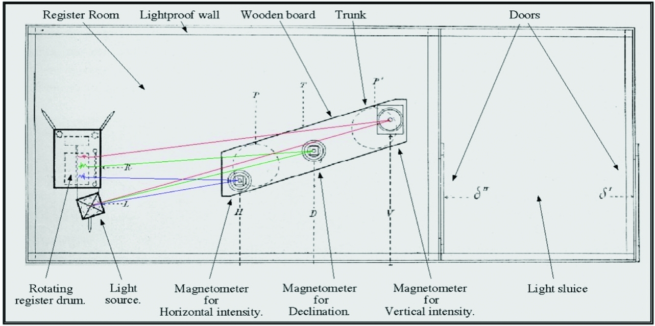
Fig. 5. Ground plan of the variometer hut at Novaya Zemlya (Fig. 9). The instruments are arranged according to the Eschenhagen pattern. Light beams from the lamp to the variometers and back to the register drum are marked by the present author in red, green and blue (Birkeland, Reference Birkeland1908, p. 33).

Fig. 6. A petroleum-burning lamp used to create beams of light for the variometers. The lamp featured a series of adjustments to optimise its use, including colour filters, a micrometrically adjustable slit, and position controls. Photograph: Museum of Science and Technology, Oslo, Norway.

Fig. 7. Registering apparatus no. 17 (Toepfer & Sohn, Reference Toepfer1907). This model was used at the stations in Iceland, Kåfjord and Novaya Zemlya (Birkeland, Reference Birkeland1908).
However, to incorporate the variometer, the lamp and the recorder into a single working unit, a series of provisions was needed (the third element). These included a supply of oil for the lamp, a sufficient amount of unexposed photographic paper, chemicals for the development process and a secure box for storing the magnetograms.
Further, as the magnetic perturbations were recorded by a beam of light from a moving mirror, even minute vibrations or shaking of the three variometers would disturb or destroy the registrations. For reliable measurements, therefore, the instruments had to be placed on a sturdy table or a series of concrete or wooden pillars, functioning as vibration-free optical tables inside the huts (the fourth element). The construction of these tables could vary from station to station; for example, at Novaya Zemlya the instruments were placed on a wooden board, resting on one or two thick posts or trunks, sunk deep into the ground and surrounded by heavy stones. At Spitsbergen, the foundations consisted of three blocks of concrete, made from cement cast around natural rock formations protruding from the ground (Fig. 8). Although in contrast with the high-tech apparatus placed on top of them, these rough foundations were crucial for producing usable data (Umbreit, Reference Umbreit and Capelotti2015). Already the question of what to include in the definition of a scientific instrument is evident.

Fig. 8. Russeltvedt's instrument-foundation at Axeløya, Spitsbergen. Photograph: P. K. Reymert, 2011.
As the magnetograms were produced by a light-beam drawing on photographic paper, no disturbing light could be present. Therefore the whole set-up had to be placed and operated in a totally dark, lightproof room, as inside a camera (the fifth element). The main purpose of the variometer huts was to keep the variometers in darkness and protect them from the weather. They also kept the temperature reasonably stable and prevented condensation from forming on the metallic parts. The construction of these huts could also vary a little. At Dyrafjord, the hut was sunk completely into the ground and consisted of three rooms, one with a flight of steps to ground level, a storeroom, and the inner register room. The hut at Spitsbergen was made from prefabricated parts transported by ship from Tromsø, and consisted of two rooms, with the instruments placed in the inner one. These sheds were crucial for successful data collection, and can therefore be regarded as part of the ‘bigger instrument’. Specially designed buildings to house scientific instruments were not new ca. 1900, however. Some medieval churches, for example, have small observatories integrated into the structure, with the building itself acting as part of a scientific instrument for studying the shadows and movements of the sun (Heilbron, Reference Heilbron1999). In the classical astronomical observatory there are special architectural features that facilitate the installation and use of instruments such as telescopes and meridian circles, which would be unreliable and almost useless in buildings without such distinctive features. The design of the variometer huts by Birkeland and his assistants in the Arctic was far from such architectural masterpieces (Fig. 9). However, the simple wooden walls, half sunken in the ground, the tar-papered roofs, and the stones along the walls and on the roof to weigh it down all served a similar purpose. They provided the necessary darkness and weather protection etc. that were crucial for the apparatus to yield meaningful results, and can thus be regarded as part of the instrument itself.

Fig. 9. The variometer hut at Novaya Zemlya, where magnetograms were produced (Birkeland, Reference Birkeland1908, p. 35). Can the lightproof walls and the roof in this case be regarded as parts of a scientific instrument?
All in all, the apparatus for detecting magnetic phenomena consisted not only of the variometer. Other instruments, such as the recorder, the lamp and the chronometer, were necessary parts of the arrangement. Additional hardware, from lamp oil and photographic paper to the heavy instrument-foundations and the buildings themselves, were also crucial.
The personnel
The concept of a scientific instrument can be extended even further. A sixth element includes the manual work undertaken by the expedition members. Birkeland's Arctic workers were all young men. The stationmasters, Richard Krekling (unknown dates) at Kåfjord, Nils Russeltvedt (1875–1946) at Axeløya, Sem Sæland (1874–1940) at Iceland, and Hans Riddervold (1877–?) at Novaya Zemlya, were all science graduates from the University of Kristiania. Among the assistants were an engineer (O. Egenæs at Kåfjord), an electro technician (Harald Hagerup at Spitsbergen), a local worker (Larus Bjørnsson at Iceland), and an Arctic explorer (Johan Koren) and an ornithologist (Hans Schaanning), both at Novaya Zemlya. It has not been possible to retrieve all the dates and first names of the personnel.
Their work on the stations was highly disciplined and required training of both body and mind. To some extent these observers, their punctuality, patience and knowledge, could be described as being part of the instrument, although perhaps not to the same extent as when ‘human travellers become surveying instruments’, as in the Indo-British exploration of Central Asia in the nineteenth century (Ray, Reference Ray, Bourguet, Licoppe and Sibum2002, pp. 156–188).
To produce reliable magnetograms the instruments had to be attended to once per day, with the operator following a strict routine. After entering the hut (Fig. 5), he had to remove and store the exposed paper, wind the drum clockwork, check and refill lamp oil, noting the date, time and temperature, and finally put a new, unexposed paper on the drum. Most operations performed inside the hut had to be done in darkness or in a faint red light from an oil lamp, as the photographic paper was insensitive to light of this wavelength. When entering and leaving the hut, the doors had to be opened and closed in the right order, otherwise stray light could ruin a 24-hour recording. The operator then had to carry away the exposed paper in a lightproof box for careful photographic developing, to be stored later in a dry and dark place. Much of the work here involved gestural knowledge, in that the right gestures combined with necessary knowledge were needed to operate the instruments (Sibum, Reference Sibum1995).
The living conditions varied at the four stations, and the quality of the magnetograms (Fig. 3a) was to some extent dependent on both the living conditions and the social functionality of the group, like a seventh element. Factors such as food, clothing, accommodation, health and safety are all important under extreme conditions. Living close together in a small, isolated group during the long, dark Arctic winter could have been a social challenge. Disagreements, lack of cooperation, quarrelling, etc. could have influenced the regularity and quality of daily duties. At Spitsbergen and Novaya Zemlya, snowstorms made it almost impossible to go outside, yet the workers had to leave the living quarters at least once each day to check the recordings. From Spitsbergen, Russeltvedt reported that during severe snowstorms they had to go two persons arm in arm the 40 metres to the variometer hut, so as not to be lost in the snow, one bringing the chronometer, the other a gun to protect them against possible attacks by polar bears (Russeltvedt, Reference Russeltvedt1903).
That such human factors had an influence on the quality of the scientific data is illustrated by some short notes attached to the registration logs for the absolute magnetic measurements from the four stations (Notes, 1903). At Kåfjord, for example, a component belonging to a particular instrument was lost during the journey and replaced by a spare, but the original was found later and reinstalled. This note indicates that the series of measurements was not thought to be as reliable as it would have been with the original part in place all the time. In another series of measurements, one recording is described as uncertain due to a misplaced magnet close to the instrument. Similar issues have also been reported from other Arctic expeditions (Levere, Reference Levere1993, pp. 278–282). From Novaya Zemlya there were reported instances of the operator forgetting to write down the time of a recording, and one observation was described as ‘difficult and perhaps less accurate’ because of the accumulation of snow heaps between the observatory and an outside calibration mark, suggesting insufficient snow-shovelling by the personnel. At Dyrafjord there were no complete measurements of the absolute magnetic intensity because Sæland was unable to stand upright for the two or three hours necessary to complete the registration because of a bad knee (Sæland, Reference Sæland1907). Of the only three measurements of declination and horizontal intensity that were made, one is described as ‘perhaps less accurate on account of the darkness’. However, the account from Axeløen contains no remarks that suggest weakness in the quality of the registrations. It is also clear that the person in charge there, Russeltvedt, managed to improvise and build a device for detecting the magnetic declination from spare parts at the site.
Moreover, it is clear that Sem Sæland had a key role during the expedition, calibrating the instruments at both Kåfjord and Novaya Zemlya, and taking charge at Dyrafjord, which suggests that he was the one among the crew with the most knowledge and experience of geomagnetic investigations (Birkeland, Reference Birkeland1908).
After the expedition was completed, Birkeland rewarded the stationmasters with medals. Riddervold got a silver medal for undertaking his duties ‘to Birkeland's satisfaction’. Russeltvedt, however, received a gold medal, ‘for having worked under the worst conditions, but who came back with the best results’ (Birkeland, Reference Birkeland1903a). It can therefore be concluded that the ‘Spitsbergen Instrument’ worked better than the ‘Novaya Zemlya Instrument’.
No science in the sense of knowledge production was performed or developed during the stay at the Arctic stations. This is an example of a relationship between scientist and technician in which the technicians have the function of a servant only. This relationship lacks the dynamic and more complicated dialectics that exist between the scientist and the technician working together in a laboratory. When the personnel later described their experiences at the Arctic stations, their accounts contained stories about hunting, local flora and fauna and the weather, but almost nothing about the daily duties, including taking magnetic recordings and weather observations (Riddervold, Reference Riddervold1961; Sæland, Reference Sæland1907; Schaanning, Reference Schaanning1916a, Reference Schaanningb). Once learned, the task of taking care of the variometers was performed more or less automatically. With the instructions given beforehand, and without any communication with Birkeland, at least at Spitsbergen and Novaya Zemlya, the observers themselves functioned as pre-programmed elements of the greater instrument (Fig. 10).

Fig. 10. Birkeland's assistants at the Novaya Zemlya station, inside the Borisov Dome, winter 1903. From left to right: Hans Riddervold (1877–unknown), Johan Koren (1879–1919) and Hans T.L. Schaanning (1878–1956) (Schaanning, Reference Schaanning1916a). With the instructions given beforehand, and without any communication with Birkeland during the stay, to what extent did these young men function as pre-programmed elements of the greater instrument?
Instrument making
If the issues described above can be described as parts of the instrument, Birkeland's effort in organising the expedition was an instrument-making operation.
The planning, organising and implementation of the Norwegian Aurora Polaris Expedition involved a great effort. The preparations included travel by Birkeland and some of his assistants to instrument makers in Germany, to be acquainted with various types of equipment and discuss modifications and purchases. There was also engagement in diplomatic correspondence between Norway, Sweden and Russia, within a tight time schedule, regarding the Novaya Zemlya station. Applying for funding, employing crew members, establishing contacts with hunters and whalers, negotiating transport and accommodation, and procuring and borrowing instruments were all necessary elements in establishing the four ‘instruments’ in the Arctic. The prime scientific instrument itself, the variometer, was in this case only a link in the chain by which the whole operation was connected to the natural phenomenon of interest (terrestrial magnetism).
In principle, the modern devices used at the Tromsø Geophysical Observatory are performing the same functions as the old instruments did at the four stations a hundred years earlier, but now including the necessary human activity. What has taken place over the years is that the human operations, gestures and procedures that were necessary to operate the old instruments are now built into the modern devices, with the output being much the same (Fig. 3).
Aftermath
Using the results
In September 1903 Birkeland started to examine the Arctic magnetograms, but he soon realised that he needed more money and fewer duties to do so thoroughly. Unlike the well-known Norwegian polar explorers Nansen and Amundsen, who both let much of the material from their expeditions be analysed by scientists and did not participate in the analysis themselves, Birkeland did most of the work alone, with help from only a few assistants.
In an application to the Ministry in 1903 he asked for a grant of 10000 kroner, equivalent to two times his annual salary as a professor, to be able to work with the material from the expedition. To strengthen his case, he applied a metaphor about building practice also used by the scientist Henri Poincare (1854–1912). When preparing for the expedition, he had used great political, utilitarian and scientific arguments when applying for funding. Now, when all the personnel had returned safely to Kristiania with their logs and recordings, Birkeland compared the outcome with a ‘dead heap of stones’. The work of a scientist was like building a house (Poincare, Reference Poincare1905), and the expedition could be compared to the work of bringing stones together on a building site. Unstudied scientific data were just as dead as a heap of stones. To analyse the data and draw conclusions was like the important and difficult work of erecting and finishing the construction (Birkeland, Reference Birkeland1903b). Although these arguments were rhetorical, they show that Birkeland regarded the magnetograms themselves as almost without value unless they were used as foundations for discussions and conclusions. When Birkeland analysed the various magnetograms and drawn maps of atmospheric currents in the following years he found there was in principle no difference between the magnetograms obtained by his four Arctic groups and those obtained by letters of request from more southerly stations. In addition to those from his own stations he had received numerous recordings from the same period from 23 other observatories: Honolulu, Sitka, Baldwin, Toronto, Cheltenham, San Fernando, Stonyhurst, Kew, Val Joyeux, Uccle, Wilhelmshaven, Munich, Potsdam, Pola, Pawlowsk, Tiflis, Jekaterinburg, Bombay, Dehra Dun, Irkutsk, Batavia, Zi-ka-wei and Christchurch. He worked with the data for several years, and the first results were published in the first part of his work The Norwegian Aurora Polaris Expedition (NAPE) in 1908 (Birkeland, Reference Birkeland1908, p. 38). The term ‘Aurora Polaris’ in the book's title was used to indicate that the aurora occurred close to both the north and the south poles (Egeland & Burke, Reference Egeland and Burke2005, p. 14). From this point of view, the Norwegian Polaris Aurora Expedition 1902–1903 can be regarded as four ‘great instruments’ that Birkeland devised to obtain enough data to support his theories.
Birkeland did not make much use of the data from the other instruments at the stations. He found the absolute measurements of terrestrial magnetism were not so important for his future work. The meteorological observations were never used either, although in 1908 he announced he would use them in future work. There was significant interest in meteorology among the international scientific communities at that time, but Birkeland did not contribute much. The phrase used in his applications, a revolution within meteorology, was nonetheless helpful in his search for funding.
Greater plans
Birkeland needed more data, and set forth an ambitious plan to equip ten similar expeditions to the Arctic and ten to the Antarctic (Birkeland, Reference Birkeland1908, p. iv). He thought this could be made possible financially by accompanying whalers and hunters, an idea that can be understood by his experiences from the 1902–1903 expedition. At the time, Norwegian whaling interests in the Antarctic had begun to develop, with the establishment of a whaling station on South Georgia in 1904 (Roberts, Reference Roberts2011; Tønnessen, Reference Tønnessen1970). However, for various reasons, these great plans were never realised.
Birkeland's theory
Birkeland's theory about the sun–aurora connection was regarded positively by some scientists in continental Europe. However, his ideas were resisted by the so-called ‘British School’, which aligned with Lord Kelvin's claim that particles from the sun could not have any influence on Earth, across empty space. (Egeland & Burke, Reference Egeland and Burke2010, p. 20). Faithful to Lord Kelvin's belief, the British geophysicist Sydney Chapman (1888–1970), when developing his own theory in the 1930s about auroras and magnetic storms, was apparently convinced that it was impossible for electrical currents to cross space, and that such currents, where they existed, could come only from the Earth (Chapman & Bartels, Reference Chapman and Bartels1962; see also Rypdal & Brundtland, Reference Rypdal and Brundtland1997). Birkeland's ideas about auroras and field-aligned currents in the Earth's atmosphere, coupled to current systems in interplanetary space, were not fully recognised until satellites confirmed their existence in 1973 (McPherron, Russell & Aubry, Reference McPherron, Russell and Aubry1973). Today these currents are recognised as horizontal electrojets in the ionosphere and are now generally called ‘Birkeland currents’.
Conclusion
The activities on Kristian Birkeland's aurora expedition in 1902–1903 are here used to discuss an extended concept of a scientific instrument. The purpose of the expedition was to make recordings of terrestrial magnetism at four locations in the Arctic.
It becomes clear that the main instrument, the variometer, was only one in a series of other devices that were needed to detect and record the phenomenon. Further, the successful outcome of the expedition was dependent not only on the scientific instruments themselves but also on the external equipment, buildings, camp facilities and the manual work performed by the expedition members. Compared to modern devices producing similar recordings, Birkeland's stations can be likened to four ‘greater instruments’, consisting of all these elements. If the issues described above can be described as parts of the instrument, Birkeland's effort in organising the expedition was an instrument-making operation.
The celebrated instrument itself, the variometer, now a typical museum artefact, would have been useless without these other elements. In fact, the magnetometers were only a link in the chain by which the whole operation was connected to the natural phenomenon of interest. Alternatively, it may be described as a point where nature meets culture (Fig. 11). Despite Birkeland's efforts in arranging the expedition, it was not an expedition in the sense of brave people travelling to new and dangerous places for the discovery of unknown land or investigations of Arctic wildlife, plants, geology or oceanography. The voyages of the Norwegian polar heroes Nansen and Amundsen better fit this image. In short, Kristian Birkeland's aurora expedition was a great undertaking to obtain exact values of some well-known natural phenomena at distinct times and locations.

Fig. 11. Nature vs scientist II. Birkeland studied a natural phenomenon using scientific instruments (red). However, a well-established infrastructure, consisting of auxiliary equipment (yellow), buildings and supplies (orange), routines (green) and personnel (grey), was also necessary. The magnetograms (white) were the output of the whole undertaking. Compare with Fig. 1.
Acknowledgements
I wish to thank friends at the Department of Archaeology, History, Religious Studies and Theology at University of Tromsø, Norway, for many interesting discussions and helpful suggestions during this work. Special thanks are due to Hans Magnar Johnsen at Tromsø Geophysical Observatory (TGO), for reading and checking the manuscript.


