


Later Medieval Bruges and its Harbour Network
From at least the tenth century onwards, political and commercial power became centralized in Bruges, in the County of Flanders in Belgium. During the following centuries, Bruges evolved into an international harbour that functioned as the primary trading hub between the Mediterranean and northern and western Europe. The town quickly expanded and at its peak in the thirteenth century had some 50,000 inhabitants, including several diaspora communities of foreign merchants and powerful financiers, as well as leading political and artistic elites, becoming a ‘cradle of capitalism’ (Murray, Reference Murray2005).
While the town was confined within its walls, the commercial and portuary infrastructure extended well beyond, into the landscape to the north-east of the city. From the late twelfth century onwards, several small harbours emerged in the immediate vicinity of Bruges along the Zwin tidal inlet, which was connected to Bruges via a smaller canal only navigable by smaller barges (De Smet, Reference De Smet1937; Leloup & Vannieuwenhuyze, Reference Leloup and Vannieuwenhuyze2013). Damme, Mude, Monnikerede, Hoeke, and Sluis all became important medium- to small-sized outports, serving as transhipment points for goods destined for the Bruges market (Figure 1).

Figure 1. The late medieval harbour system of Bruges and its principal harbours and towns. Underlining indicates the presence of ballast stones.
Although each of these outports was legally an autonomous community with its own town rights, politically, financially, and commercially the small harbours largely depended on, and were monitored by, Bruges (Fossion, Reference Fossion1992; Sosson, Reference Sosson, Contamine, Dutour and Schnerb1993; Dumolyn & Leloup, Reference Dumolyn, Leloup, Solórzano Telechea, Arízaga Bolumburu and Bochaca2016). We can consider Bruges’ commercial harbour and related port society as an integrated ‘portuary network’—a densely occupied and urbanized medieval landscape stretching along the Zwin over a distance of nearly 20 km between Bruges and the mouth of the Zwin near Sluis. The silting of the inlet, as well as economic and political factors, led to the collapse of the system at the end of the fifteenth century. Some of the small harbour towns even vanished and now constitute a substantial yet largely unknown part of the Flemish archaeological heritage.
Bruges was economically and culturally one of the most important cities of later medieval Europe, but, apart from some categories of ceramics, remarkably few material proxies of its varied connections have been studied archaeologically (see e.g. Hurst & Neal, Reference Hurst and Neal1982; Hillewaert, Reference Hillewaert1993; Pieters & Verhaeghe, Reference Pieters and Verhaeghe2009). This is particularly the case in the context of Bruges as a Hanse Kontor within the so-called ‘Hanse Archaeology’, as it is for harbours such as London (Gaimster, Reference Gaimster1999; Mehler, Reference Mehler and Smith2014: 3214; Wubs-Mrozewicz, Reference Wubs-Mrozewicz, Brand and Knol2010).
A cross-disciplinary study of material culture in harbour zones like that of Bruges is also particularly relevant for debates on maritime societies (Westerdahl, Reference Westerdahl1992, Reference Westerdahl2014) and for acknowledging the vital and multi-layered role material culture played in the later medieval commercial, political, and cultural exchange networks, such as the ties that linked them to the Burgundo-Aragonese spheres (De Clercq et al., Reference De Clercq, Braekevelt, Coll Conesa, Kaçar, Vicente Lerma and Dumolyn2015) or the Hanseatic League (Immonen, Reference Immonen2007; Mehler, Reference Mehler2009, Reference Mehler and Smith2014, Reference Mehler, Hansen, Ashby and Baug2015; Gaimster, Reference Gaimster2014). New, comprehensive research must therefore include the socio-economic and cultural impact of important diaspora communities like the Catalans, Genoese, and the so-called Easterlings or merchants of the German Hanse, noticeably present from the thirteenth century onwards in Bruges port-societies and the landscape (Beuken, Reference Beuken1950, Vandewalle, Reference Vandewalle2002). Such a study could be conducted by using material culture to assess the cultural impact of international networks such as that of the Hanseatic League (Gaimster, Reference Gaimster2014; Mehler, Reference Mehler2009, Reference Mehler, Hansen, Ashby and Baug2015) on local society and culture.
But, under the radar of high-status cultures, more mundane, everyday objects floating just underneath the surface of a sea of conspicuous material culture may provide us with another valuable line of inquiry. These can help us assess transformations and interactions in everyday life, often partially playing out at a discursive level. In this vein, we believe that the study of material culture in these port societies should not be restricted to the identification of Hanseatic elements and identity, but should include the interactions that existed between different material cultures, thereby creating new complex lifestyles and material worlds within later medieval Europe. Our aim is to integrate these frameworks in a cross-disciplinary context. More specifically, this study examines ballast as a valuable indicator of international mobility and exchange in the harbours and port landscape of Bruges and its wider northern European context.
Ballast as an Archaeological Object Category
Ballast is one of the most obvious object categories encountered in harbours for seagoing vessels. It is also one of the most direct material evidences of international mobility within port societies. But little is archaeologically or historically known about ballast, since it is often considered a meaningless group of objects—‘ballast’ in the figurative sense. The reason for this ignorance may be found in its general lack of economic value, the paucity of written sources, and, above all, the varied and often complex mechanisms for acquiring, using, disposing, and re-using ballast. This may be especially true of the Hanseatic League—initially a loose association of merchants before it matured into an urban league and commercial superpower in the middle of the fourteenth century—which organized its trade by using several harbours as stepping-stones between the source and destination of commodities (Dollinger, Reference Dollinger1998: 278–81).
Buckland and Sadler (Reference Buckland, Sadler and Parsons1990: 121), in a thorough overview of ballast and building stones in maritime trade, critically highlighted these distributional problems by arguing that careful study of ballast stone from excavations and buildings may reveal trading connections, but that in the case of northern Europe the effects of multiple glaciations and the reshipment of ballast could lead to errors. Peacock (Reference Peacock1998: 13–15) remarked on the neglected potential of ballast, considering it to be due to various difficulties in studying and interpreting collections of such material. He outlined some major conditions and constraints in this respect: the ability to identify geological and geographical signatures or provenances within assemblages of stones, as well as the fact that an assemblage may represent a heterogeneous mixture caused by various natural and human factors. Mehler (Reference Mehler, Hansen, Ashby and Baug2015: 367–68) recently noted that ballast was still being largely overlooked, adding that little is known about the ‘ballast-industry’ and the people who collected, transported, loaded, and reshipped ballast.
Stone ballast should indeed be approached cautiously as it may conceal many complexities. But that does not mean it should be ignored as a valuable and independent category of archaeological objects. Westerdahl (Reference Westerdahl1989: 110–17) acknowledged the great potential of ballast sites in his survey of Norrland. Buckland and Sadler (Reference Buckland, Sadler and Parsons1990: 118–19) convincingly addressed the late-medieval link between Hull and the Icelandic fisheries, underpinning their work with a near-contemporary account that explicitly mentioned ships carrying stockfish from Iceland ballasted with Icelandic cobbles, which were subsequently re-used in the town's paving; this would suggest fairly direct trade. Similar observations could be made further south in King's Lynn, Norfolk, where a cross-disciplinary study identified a vast amount of Baltoscandian metamorphic and igneous rocks in the medieval town wall (Clarke & Carter, Reference Clarke and Carter1977: 440; Hoare et al., Reference Hoare, Vinx, Stevenson and Ehlers2002). In Belgium, a combined archaeological-petrological study of unworked stone from the medieval fishing village of Walraversijde (De Paepe & Pieters, Reference De Paepe and Pieters1994) pinpointed the source of this material to the north-eastern or eastern coast of Britain. Most probably the ballast was carried by returning herring-ships that called at ports in this area, as well as ships carrying coal from Newcastle-upon-Tyne (De Paepe & Pieters, Reference De Paepe and Pieters1994). Much earlier, Munthe (Reference Munthe1942) had demonstrated the value of biological indicators (molluscs) to assess the ballast found in Fårö in North Gotland. These studies show that critical and cross-disciplinary research offers the greatest potential for addressing and eventually overcoming interpretational flaws when examining large assemblages of ballast stones.
Exotic Stones in a Stoneless Landscape
Although ballast stones would be expected in a port landscape like Bruges, the presence of stones of exotic geological nature has only recently been reported. A study of building materials used in the thirteenth-century church of Our Lady and its surrounding paths in the harbour town of Damme has revealed at least twenty different types of natural stones, including—uniquely in Belgium—pink granite and black amphibolite boulders (Debonne & Dreesen, Reference Debonne and Dreesen2015). These stones are geologically exotic to Flanders and neighbouring areas, and their morphology indicates a long stay in moving water. This suggests that they were probably imported from remote coastlines and were brought to the region of Bruges as ballast.
The same observation was made in the tower of the early Gothic church of Saint Guthago and Saint Quinten in the nearby village of Oostkerke, which served during the later medieval period as the principal church for the nearby harbour of Monnikerede. Exotic cobbles were also found in the tower and footpaths surrounding the church of Saint Bavo of Aardenburg some 15 km to the north-east of Bruges. This was an important medieval place of pilgrimage and commerce that briefly hosted the principal seat of the Hanse in the thirteenth and fourteenth centuries following disputes with Bruges. Moreover, excavations revealed similar exotic stones in the castle of the fifteenth-century new town of Middelburg-in-Flanders, located a few kilometres south of Aardenburg and east of Damme.
These initial observations lead to systematic screening for similar stones in monuments and archaeological sites within the Bruges port landscape. This study not only took into consideration monuments and infrastructure such as churches and paths, but also data from intensive field surveys of lost harbours sites. It revealed considerable amounts of boulders and cobbles of exotic metamorphic, igneous, and sedimentary lithological nature at Damme, Monnikerede, Westkapelle, Sluis, and particularly at the lost harbour site of Hoeke, where such stones were recovered by the thousands. The often vividly coloured, well-rounded stones occur in a preserved segment of a later medieval road and are found throughout the pathways surrounding the old farm that still stands on part of the site (Figure 2). Ploughing of the rest of the lost town reveals new cobbles every year.

Figure 2. Path cobbled with geologically exotic ballast stones at a farm standing on the lost (Hanseatic) harbour site of Hoeke.
Although found in the stoneless landscape of northern Flanders, these remarkable, colourful stones were clearly not primarily imported as building material. The water-worn shape and the often very hard texture make these boulders and cobbles unsuitable for the elaborately sculptured and elegant Flemish Gothic architecture. Sandstone and limestone, which could be worked much better and was ideal for building, was already imported in large quantities from the tenth century onwards from the Scheldt valley, the German Eifel area, or from northern France and constituted the primary choice of building materials, along with brick. The rounded stones, on the other hand, were merely used in cobbled paths, modest floors, or wall repairs. Their occurrence in buildings and infrastructure can therefore only be considered to represent a final recycling stage in a much more complex cultural biography.
The stones’ spatial distribution within the port-system of Bruges seems to be related to the evolution of the harbours that bordered the Zwin. No stones have been found along the Old Zwin system, located somewhat further to the north. The phenomenon appears connected to the latest Zwin, and hence with the floruit of the international trade in the region between the twelfth and fifteenth centuries. The fact that no such stones have been uncovered during architectural or archaeological investigations in Bruges itself supports this hypothesis. The large sea-going galleys and cogs needing ballast did not reach Bruges, but remained in the better navigable outer ports, situated closer to the sea in the deeper water of the inlet, where their cargo was transhipped into smaller boats with lesser draught. These vessels then sailed to Bruges via the shallower western part of the Zwin and a canal extending eastward from Bruges to reach the tidal inlet in Damme.
Assessing the Geological Origin and Geographical Provenance of the Stone Assemblage
Methodology
We investigated the most probable geological and geographical provenance of the stones, and related these to the local distribution pattern and historical context. First, a random, non-exhaustive inventory of stones finds was made, resulting in a set of 444 specimens of which the clear majority (over 90 per cent) came from the surface of the Hoeke site. The stones were grouped into lithological classes according to their macroscopic properties. A selection of cobbles (about 10 per cent) was sliced and polished to allow us to better assess their mineralogical properties. Further, limestone boulders displaying tubular burrows were selected for thin-sectioning and additional microfacies and micropalaeontological investigation. All inventoried stones were measured and counted for their relative frequency and size distribution in order to help establish the mechanism by which they were transported.
The rocks’ exotic nature, specific lithological spectrum, and overall morphology pointed to the presence of so-called ‘erratics’, i.e. cobblestones initially transported by glacial ice. For the study of such erratics, a descriptive petrographic terminology is preferentially used (hammer and handlens) rather than a petrological approach using sophisticated mineralogical and geochemical tools. This descriptive method is rapid and can be used for large quantities of materials, but whenever this subjective determination fails, comparison with reference material, complemented by examination under microscope if necessary, should be used. Hesemann (Reference Hesemann1975) and Zandstra (Reference Zandstra1983, Reference Zandstra1988) proposed a pragmatic subdivision of the Fennoscandian provenance areas to support the quantification of erratics and the statistical analysis of north-western European till deposits. The increasing number of erratics collectors and students of erratics geology has resulted in numerous well-illustrated digital resourcesFootnote 1 with high-quality digital atlases a well as user-friendly keys for their determination (e.g. Smed & Ehlers, Reference Smed and Ehlers2002).
Lithology
The analysis of the 444 cobble specimens shows a broad lithological spectrum and excludes local provenance. There is an almost equal distribution between igneous (34 per cent), metamorphic (28 per cent), and sedimentary (38 per cent) rock types (Figure 3), but with a predominance of red sandstones and irregular rounded flint cobbles (Figure 4). The sedimentary rocks include different varieties of sandstones, micro-conglomerates, and flints, as well as limestones. Sandstones are fine- to coarse-grained, with greyish-green, beige to crimson colours. Granules and micro-conglomerates containing milky-white quartz and red sandstone pebbles and arkosic to greywacke-type sandstones also occur. Most of the inventoried sandstones are insignificant with respect to provenance, except for a medium-grained yellowish sandstone displaying angular cross-bedding, whose foresets are impregnated with purplish iron and manganese oxides. The latter can be tentatively assigned to the Kalmarsund (Strait of Kalmar between the Swedish mainland and Öland) sandstone. The limestone boulders consist of grey, beige to pinkish-brown bioclastic limestones, enclosing crinoids and small solitary rugose corals. The presence of subrecent borings made by pholads and bristle worms is most conspicuous. Micropalaeontological analysis of these limestones has led to detailed biostratigraphic dating and a probable provenance area, supported by biological evidence (see further below).

Figure 3. Proportion of the lithological groups of rocks identified among the cobblestones.

Figure 4. Frequency and size analysis of the inventoried lithological species among the cobblestones.
Grey-hued flints are quite common in the study material. Occasionally they enclose white-shelled echinoids or bryozoan colonies. Bryozoan-bearing chalks enclosing flint are quite common and are well exposed in the topmost Maastrichtian (Cretaceous) and Danian strata (earliest Palaeocene) of the coastal cliffs in south-eastern Denmark and the Rügen peninsula in north-western Germany. The high frequency and irregular shape might indicate a nearby source and hence a shorter distance for transport. The white chalk Jasmund cliffs of the Rügen peninsula (Neumann, Reference Neumann and Witzmann2012) are potential provenance areas. Yet the number of bryozoans in some of our flints could point to the bryozoan-rich chalks of south-eastern Denmark (Stevns Klint, Möns Klint) as a potential source (Surlyk et al., Reference Surlyk, Damholt and Bjerager2006). However, additional palaeontological or geochemical investigation is required to confirm this (Högberg et al., Reference Högberg, Olausson and Hughes2012).
Metamorphic rocks include various dark-coloured gneiss, dark-grey micaschists (rare), dark-green to black amphibolites (most frequent), augen-gneiss and granite-gneiss (frequent), cream-coloured quartzites, and milky-white vein quartz. But their value as indicators of provenance is poor, especially compared to that of the igneous rocks. These represent the most exotic and the most significant part of the lithological spectrum in our findings. They consist of various types of felsic and mafic granites, porphyries, and many transitional forms, most of which display vivid (e.g. red) colours. Extrusive rocks are only represented by frequent, dark-coloured ignimbrites and very rare agmygdaloid basalt. Although many of these igneous rocks could have come from anywhere (e.g. Scotland, Brittany), some specimens have a restricted geological source area.
While the lithological suite of the cobbles as a whole may not be indicative of a single provenance, their well-rounded shape, perfectly smooth surface (regardless of lithology), excellent sorting, and the presence of subrecent bioturbations all point to a coastal pickup area: cobble beaches. Moreover, the presence of particular key erratics or indicator cobbles points to a probable Baltoscandian origin. The latter have a long transport history: first they were eroded from the Precambrian Scandinavian basement and overlying Early Palaeozoic formations and then they were transported during the last Ice Age by continental glaciers flowing down from the Scandinavian mountains, often over distances of hundreds of kilometres (Smed & Ehlers, Reference Smed and Ehlers2002). After melting and retreat of the continental glaciers, terminal and ground-moraines left behind huge amounts of glacial till, consisting of an unsorted mixture of clay, sand, pebbles, cobbles, and boulders. The stones were subsequently reworked and sorted by sea currents or surges and redeposited along the coasts, creating cobble beaches. Erratic cobbles and boulders cover many beaches in the southern Baltic Sea region (Reinicke, Reference Reinicke2011; Rudolph, Reference Rudolph2014), such as those bordering the former Hanseatic towns of Lübeck, Rostock, Stralsund (Rügen), and others.
The presence of indicator or key erratics (Leit-Geschiebe in German) points to provenances within the Baltoscandian area. The cobbles and boulders were deposited, and subsequently picked up, far away from their original geological sources. We suppose that most of the sedimentary rocks (e.g. red sandstones), except the flints and limestones, derive from the Early Palaeozoic strata covering the crystalline Proterozoic basement rocks (Smed & Ehlers, Reference Smed and Ehlers2002). A description of some of the most distinctive key erratics found in our material follows.
Larvikite is an igneous rock, more specifically a monzonite or alkaline syenite composed of quite large crystals of bluish-grey feldspars (alternating layers of alkali feldspar and plagioclases) with spectacular reflections—the famous silver-blue iridescence or labradorescence. It has been derived from the plutonic complex of Larvik (the Larvik Batholith) in the Carboniferous-Permian Oslo graben in south-eastern Norway (Zandstra, Reference Zandstra1988; Smed & Ehlers, Reference Smed and Ehlers2002; Heldal et al., Reference Heldal, Kjolle, Meyer, Dahlgren and Slagstad2008). Many varieties exist based on their overall colour, but the alteration generally results in discoloration and bleaching of the rock (Venema & Egbrink, Reference Venema, Egbrink, Nijland and Laban2015). Our specimens show a distinct light-silvery grey colour (Figure 5: 1).
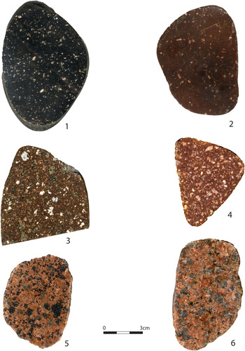
Figure 5. Photographs of polished surfaces of sliced key erratics from the Bruges area. 1. Blyberg porphyry (ignimbrite) (sample HO-23); 2. Red Dala feldspar porphyry (sample HO-19); 3. Grönklitte porphyry (sample MON-2); 4. Bredvad porphyry (MON-3); 5. Pyterlitic Rapakivi granite (HO-58); 6. Red Småland Granite (HO-57).
Kalmarsund sandstone is a cross-bedded medium-grained sandstone belonging to a series of sandstones probably derived from the Early-Cambrian File Hadar Formation. The red to purplish banding underlining this stratification is most conspicuous, being due to the presence of iron oxides (hematite) and/or manganese oxides (Figure 5: 2). This particular sandstone comes from the area between the southernmost region of Sweden and Öland (Smed & Ehlers, Reference Smed and Ehlers2002). Bothnian Sea quartz porphyries contain many small crystals (micro-phenocrysts) of both alkali feldspar and plagioclase, besides dark grey limpid quartz phenocrysts, within a dark brown or reddish brown groundmass (Figure 5: 3). The exact geological provenance is unknown but is supposed to be located on the floor of the Baltic Sea, south-east of Stockholm, in Sweden (Zandstra, Reference Zandstra1988; Smed & Ehlers, Reference Smed and Ehlers2002).
Red, dark brown to black porphyries, often with an ignimbritic texture, represent particular igneous rock types, displaying a very fine-grained, hornfels- or flint-like groundmass with faint to visible banding (so-called ‘flames’) and containing tiny feldspar phenocrysts, mostly without quartz. Although some of the ignimbrites may derive from the Oslo area, the Swedish porphyries or ignimbrites are very conspicuous and quite common within the group of Baltoscandian glacial erratics found in central and western Europe. These derive from a large volcanic field near the village of Älvdalen (hence their name: Älvdalen porphyries or ignimbrites) located about 350 km to the north-west of Stockholm. Different varieties are recognizable based on their texture and colour (Wikström et al., Reference Wikström, Pereira, Lundqvist and Cooper2014): the black Blyberg porphyry (Figure 6: 1), the dark reddish-brown Rännås porphyry (Figure 5: 5), and the brick-red Bredvad porphyry (Figure 6: 4). The latter show numerous superficial pits caused by weathering and erosion of the small feldspar phenocrysts.

Figure 6. Photographs of polished surfaces of sliced key erratics from the Bruges area. 1. Larvikite (sample HO-28); 2. Kalmarsund sandstone (sample HO-40); 3. Brown Bothnian Sea porphyry (sample HO-18); 4. Rapakivi-type granite (sample HO-63); 5. Dalarna ignimbrite (HO-59); 6. Åland granite-porphyry or Ring quartz porphyry (HO-53).
Other common red porphyries deriving from the same volcanic area (Dala-Dalarna) are the Red Dala feldspar porphyry (Figure 6: 2) and the Grönklitt porphyry (Figure 6: 3). The latter is rich in feldspar phenocrysts and contains pale-green spots filled with aggregates made of chlorite, hornblende, and epidote crystals.
Most conspicuous and vividly coloured (often deep red) are the so-called Rapakivi-type granites. These have characteristic large rounded and rimmed feldspar crystals (ovoid alkali feldspars surrounded by a rim of plagioclase) and characteristic graphic textures (exsolved quartz typically forming a distinctive repetitive pattern resembling cuneiform writing) (Figure 5: 4). They are excellent indicators of provenance: they are thought to derive from the Åland archipelago in south-western Finland (Zandstra, Reference Zandstra1988; Ehlers et al, Reference Ehlers1989; Smed & Ehlers, Reference Smed and Ehlers2002), although similar rock types also occur in the northern part of Sweden, i.e. in Ångermanland. However, the latter lack the characteristic deep-red to brown-red colour of the Finnish Rapakivi (Zandstra, Reference Zandstra1988).
Closely related to the Rapakivi-granites are the Åland granite-porphyries and pyterlites or pyterlitic Rapakivi-granites, also derived from the Åland Islands. Red ring-quartz porphyries or Åland granite-porphyries are particular granites displaying conspicuous thin black rims of hornblende crystals that surround the dark grey (‘smoky’) quartz crystals, next to large rounded alkali feldspar crystals (Figure 5: 6). A graphic texture is also present. Pyterlites or pyterlitic granites (Figure 6: 5) are characterized by the development of coronets (‘necklaces’ of beads) of small idiomorphic quartz crystals around the large feldspar crystals (Zandstra, Reference Zandstra1988; Smed & Ehlers, Reference Smed and Ehlers2002).
A series of red- to pink-coloured granites with eye-catching blue or bluish-grey quartz crystals and red K-feldspars are known as Småland granites (Figure 6: 6). The blue colour of the quartz crystals is enhanced through polishing or wetting the stone slabs (Zandstra, Reference Zandstra1988; Smed & Ehlers, Reference Smed and Ehlers2002).
Dark-grey flints are frequently mixed with the above crystalline rocks. Their form is generally less regular and less well-rounded than that of the igneous and metamorphic stones, suggesting a nearby source area. The cobble beaches of south-eastern Denmark and northern Germany are particularly rich in flint cobbles. The latter are always mixed with the colourful igneous rock cobbles and boulders, displaying all the characteristics of reworked Baltoscandian erratics (Reinicke, Reference Reinicke2011; Rudolph, Reference Rudolph2014; Rudolph et al., Reference Rudolph, Bayer, Bartholomäus and Von Loga2015). The combination of a rich and exotic lithological spectrum, the presence of key erratics pointing to various geological sources in Norway, Sweden, and Finland, and the relative abundance of flints—taking into account the known south and south-south-west oriented transport directions of the continental glaciers (Smed & Ehlers, Reference Smed and Ehlers2002)—clearly point to the south-western part of the Baltic Sea as the most plausible pickup area for our the stones in our inventory, such as the coastal areas south of Skåne, the eastern coast of Denmark, and the northern German coastline between Lübeck and Stralsund (Figure 7).
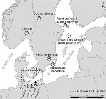
Figure 7. Simplified map of the Baltoscandic region with locations of provenance areas of identified key erratics (1–6) and flints (7: probable source area) within the material from the Bruges area.
Besides erratics and flints, several limestone boulders and cobbles are present in our study material. The latter are medium grey to liver-coloured, fine-grained crinoidal limestones, also enclosing solitary corals. Moreover, several of the boulders show large subrecent tubular burrows created by clams such as pholads, pointing to a seashore environment (Figure 8: 1, 2) Thin sections of the crinoidal limestones allowed us to undertake a detailed microfacies analysis and a good assessment of their biostratigraphic age. Microscopically, the limestone boulders consist of bioturbated bioclastic wackestones and packstones, containing echinoderms, fenestellid bryozoans, thin-shelled ostracods, brachiopods, calcareous algae, plurilocular foraminifera, and rugose corals. Key solitary corals (Siphonodendron pauciradiale) (Figure 8: 5) and index plurilocular foraminifera (Eostafella ikensis, Bradyina rotula, Howchinia sp., and Archaediscus karreri) (Figure 8: 3, 4, 6) clearly indicate a Lower Carboniferous geological age, more specifically the Late Visean. The foraminiferal microfauna indicates the standard Microfossil Zone MFZ14 (former V3b gamma zone) or the Late Asbian substage of the Lower Carboniferous (Poty et al., Reference Poty, Devuyst and Hance2006). This biostratigraphic age is corroborated by the occurrence of Siphonodendron pauciradiale, a coral species also found in the British Asbian.

Figure 8. Macroscopic features and carbonate microfacies analysis of limestone boulders. 1. Limestone boulder surface strongly bioturbated by pholads. 2. Cut limestone boulder showing tubular borings of pholads (length of burrows about 25 mm). 3. Thin section micrograph of a bioclastic wackestone showing plurilocular foraminifera, including Bradyina rotula (Eichwald) (large specimen in the middle) and Howchinia sp. (tiny foraminifer at the left). 4. Thin section micrograph of a bioclastic wackestone showing small plurilocular foraminifera: Archaediscus karreri Brady. 5. Thin section micrograph of a bioclastic wackestone showing transversal sections of the small rugose coral species Siphonodendron pauciradiale (McCoy). 6. Thin section micrograph of a bioclastic packstone with the plurilocular foraminifer Eostafella ikensis Vissarionova. All micrographs taken with parallel polarized transversal light.
The most probable provenance region of these limestone boulders is the coastal area of Northumberland, for instance near Berwick-upon-Tweed. Here, the outcropping Asbian limestone beds belong to the Tyne Limestone Formation of the Yoredale Group (Waters et al., Reference Waters, Dean, Jones, Somerville and Waters2011; Dean et al., Reference Dean, Browne, Waters and Powell2007). A link with a coastal area is also suggested by the boulder morphology (rounded nature) and by the presence of numerous pholad borings in the limestone boulders (Pholas dactylus, commonly called piddocks or angelwings) which point to an area with a coastal, intertidal habitat (MarLINFootnote 2 ). The combined geological and modern biological evidence therefore suggests that the limestone boulders were picked up along the shore, in or below the intertidal zone of the coastal cliffs of Northumberland, probably near Berwick-upon-Tweed (Figure 9).
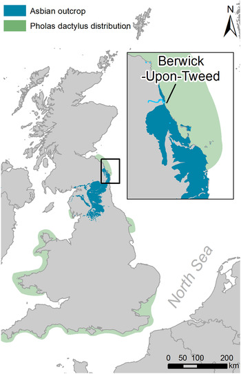
Figure 9. Map of the UK showing the geological distribution (extension) of Asbian limestones (blue) in north-eastern Britain and the modern distribution of Pholas dactylus (green). Based on data from the BGS (British Geological Survey) and marLIN (the Marine Life Information Network).
Morphology and size distribution
While the petrography of indicator erratics allowed us to identify their original area of geological provenance, the morphology of the cobbles is quite characteristic of a high-energy aqueous environment such as cobble beaches. Moreover, an overall size distribution analysis of the selected cobbles in function of their lithology demonstrates excellent sorting (Figures 5 and 10). Cobble diameters vary from 5 to 40 cm with an average of about 12 cm for all stone varieties. The morphology of the stones (overall shape, smoothness, and roundness), in combination with their quite exotic nature and the good sorting, points to a combined glacial transport with subsequent sorting and rounding by surges along seashores. The average size of the cobbles indicates both good natural sorting (by surges and waves) and human sorting by handpicking along beaches. The size and high mass density of the cobbles creates a selection of stones which are suitable for stacking when used as ballast. Cobble beaches were indeed an important primary source of medieval ballast, particularly around many Baltic ports (Hoare et al., Reference Hoare, Vinx, Stevenson and Ehlers2002).

Figure 10. Size distribution (cm) of the measured cobblestones.
Geological discussion
There are no crystalline rocks such as those described above in Belgium. The nearest coastal outcrops of crystalline rocks are located in north-eastern England, Scotland, or Brittany. However, the presence of particular key erratics suggests a Baltoscandian provenance. Furthermore, particular limestone boulders containing characteristic fossils point to the north-eastern English coast as an additional source. The import of non-indigenous ballast and building stones has already been reported in the medieval fishing village of Raversijde near Ostend (De Paepe & Pieters, Reference De Paepe and Pieters1994) and a probable fifteenth-century link with the north-eastern British coast was demonstrated there. In this case the Scottish Midland Valley and the British Tertiary Volcanic Province (e.g. the Inner Hebrides) as well as the Grampians have been suggested as the probable provenance areas for the igneous and metamorphic rock types respectively. The morphological characteristics of the ballast stones also indicate a stony coastline as the most probable pickup zone.
Hoare et al. (Reference Hoare, Vinx, Stevenson and Ehlers2002) reported re-used bedrock ballast stones as construction material in King's Lynn's medieval town wall. It was the first comprehensive survey of an impressive number of ballast cobbles. The cobbles’ considerable lithological variety was sufficiently distinctive to make it possible to identify their provenance. Besides sedimentary rocks native to the district, several Baltoscandian indicators were found, including Rapakivi-granites, rhomb porphyry, Bredvad porphyry, helleflint, Bothnian Sea porphyry, and Ordovician red orthocerate limestone. Many of the wall cobbles are of basaltic, porphyritic, and metamorphic origin, which, while not identifiable to geological sources, may also be expected to accompany the Baltoscandian indicators. The most satisfactory explanation for the presence of these water-worn Baltoscandian cobbles in the town wall of King's Lynn is that they formerly served as ballast, and the authors concluded that there was a possible link with the coast of western Estonia.
The morphological-petrographical characteristics of the re-used bedrock ballast stones at King's Lynn are quite similar to those of the area of late medieval Bruges. The occurrence of common key erratics (such as Rapakivi and pyterlitic granites, Bredvad and Bothnian Sea porhyries), their conspicuous water-worn shape, and excellent sorting, all point to a common source: the cobble beaches of the Baltic Sea. Interestingly, both in King's Lynn and in the Bruges area, these key erratics represent only a very small percentage of the total material (one per cent in the case of King's Lynn, possibly a few per cent in our study), hence the importance of a detailed investigation and the search for specific exotics among the re-used cobblestones.
Examples of a variety of Scandinavian rocks have been described in buildings from Littlehampton (West Sussex, southern England), notably in the walls of the United church, where they are mixed with flint (Birch & Cordiner, Reference Birch and Cordiner2014). These are very distinctive coarse-grained granites and gneisses such as Rapakivi-granites. As in the case of King's Lynn and the Bruges portuary area, most of the erratics have a well-rounded shape suggesting that they were subject to marine abrasion in a high-energy beach environment. However, the Scandinavian erratics are less frequent than the ‘local’ or indigenous erratics derived from the West Sussex coastal plain beaches.
The occurrence of analogous material in the UK and in Belgium points to the import and re-use of well-sorted and water-worn cobbles picked up on Baltic Sea cobble beaches. Many of the inventoried cobbles are of basaltic, porphyritic, and metamorphic origin, which, although not identifiable to geological source, may be expected to accompany the Baltoscandian indicators (Hoare et al., Reference Hoare, Vinx, Stevenson and Ehlers2002). Although crystalline rock types such as granites, ignimbrites, porphyries, quartzites, gneiss, amphibolites, mica schist, etc. could derive from less distant sources, such as the coastal areas of Scotland or Brittany, the presence of particular but rare key erratics and significant amounts of flint point to a pickup area located in the south-western Baltic Sea, such as the cobble beaches south of Skaane and along the coast of northern Germany. Moreover, microfacies and palaeontological-biological evidence suggests the additional import of ballast stones from the north-eastern coast of England (Berwick-upon-Tweed area) into the Bruges area.
‘In novam villam de Dam’: Baltoscandian Ballast in a Forgotten Hanseatic Settlement in Flanders
From a quantitative and distributional point of view, the massive occurrence of northern ballast stones at the Hoeke site stands out when compared to the other port sites within the Flemish port system, notably those located closer to Bruges. Should we interpret the Baltoscandian stones as an indicator of the firmly established trade links that existed between northern Europe and the Bruges port network during the later Middle Ages and between the harbour of Hoeke and the Hanseatic trade network in particular?
Merchants from Cologne first appear in the Zwin region around ad 1160 at Letterswerve, the Bruges outport later known as Damme (Verhulst Reference Verhulst1998; Verhulst et al., Reference Verhulst, De Hemptinne and De Mey1998). During the thirteenth century, as Bruges’ market was steadily expanding, traders from other towns, most notably Lübeck and Hamburg, seem to have increasingly frequented Bruges’ harbours. These merchants obtained privileges from the Countesses and Counts of Flanders in 1252–53, 1280–82, 1307, and 1309 and established a durable and unified Hanseatic trading community in Bruges during the first half of the fourteenth century. The sources sometimes refer to them collectively as merchants from Allemaigne and, somewhat later as Oosterlingen—traders from the towns that, around the middle of the fourteenth century, constituted the German Hanse. By that time, probably together with the English, they made up the largest community of foreign merchants in Bruges (Henn, Reference Henn1989; Vandewalle, Reference Vandewalle2002; Greve, Reference Greve2012; Murray, Reference Murray, Wubs-Mrozewicz and Jenks2012).
The Hanseatic ‘nation’, as the privileged communities of foreign traders in Bruges were known, had a so-called Easterlings House in Bruges, a guildhall, but it was only in use from 1478 onwards (Devliegher, Reference Devliegher, Jörn, Paravicini and Wernicke2000). Before that, Hanseatics lived among the local population. Murray (Reference Murray, Wubs-Mrozewicz and Jenks2012: 183) argues that, as a consequence of opposition from Bruges, Hanseatic merchants never established a separate merchant enclave with immunity under the law, thus deviating from the ‘colonisation strategy’ applied in the Kontors of London, Bergen, and Novogrod. However, at some point during the second half of the thirteenth century, the Hanse merchants tried to do so. While it was never a Hanse colony sensu strictu, there was an important and clustered Hanseatic presence and institutional intervention at Hoeke.
Indeed, between 1252 and 1255 important negotiations took place between the representatives of the German towns of Lübeck and Hamburg and Countess Margaret of Flanders (Kiesselbach, Reference Kiesselbach1900; Stein, Reference Stein1903; Henn, Reference Henn1989). They explicitly expressed their will to construct a permanent trading settlement for German merchants, a novam villam de Dam as they called it: a new town of Damme. Damme was an important outer port of Bruges, created by the Count of Flanders around 1180. It was a major harbour for the wine trade and had a crane that was owned, along with the quays, by the city of Bruges. The Germans’ request was straightforward: they wanted to build their own, new trading town. In an unsealed charter, Countess Margaret effectively approved the German request and assigned the universi mercatores Romani imperii ‘an area between our harbours of Damme and Mude and to the side of the water of the Zwin’, specifying that other Flemish and foreign merchants would also be allowed to settle there. This area is de facto situated in the territory of Oostkerke, an old and large fief to the north-east of Bruges in whose territory lie the harbour sites of Monnikerede and Hoeke. In the absence of a formal (sealed) charter confirming the countess’ approval or any other document attesting to the establishment of this new town, historians assumed the plan never actually materialized (Stein, Reference Stein1903: 67–92; Murray, Reference Murray, Wubs-Mrozewicz and Jenks2012: 183).
Yet historical sources from the second half of the thirteenth century do refer to the presence of Hanseatics in Hoeke. It is possible that this so-called novam villam de Dam, even if it was never founded in exactly the way the charter described, was in fact Hoeke (e.g. Bonte, Reference Bonte1987), and this hypothesis deserves more attention. Hoeke, literally ‘the corner’, was indeed an ideally located site within the area designated by the countess in 1252, as it lay in the northernmost corner of the Oostkerke territory, positioned as close as possible to Mude and the sea. This must have given it the important advantages of deeper and better navigable access for tall ships.
The 1292 maritime law of Hamburg states that the Hanse's seat in Flanders was in Oostkerke and thus exactly in the area the countess had stipulated: ‘and as such the Hanse shall be held in Ostkerke in Flanders and in no other place’ (Kiesselbach, Reference Kiesselbach1900: 62). The maritime law of Lübeck dated 1299 is the first to explicitly mention Hoeke (to deme Hoke) as the seat of the Lübecker Hanse (Kiesselbach, Reference Kiesselbach1900: 67). According to the Lübeck maritime law, all merchants from that town who had moored their ship in Hoeke or elsewhere along the Zwin had to pay a fee to the local Hanse organization and attend the ‘bench’ (banck) with a local Hanseatic representative (olderman) every Sunday. This court mediated conflicts between the German merchants, which implies that, although there was no Hanseatic immunity from Flemish courts, the Germans already had consular jurisdiction for conflicts among themselves in Hoeke, as they and other ‘nations’ would later also have in Bruges. The Hamburg maritime law of 1292 also mentions similar practices in Oostkerke: a representative, the payment of a fee, and a Sunday morning meeting to settle commercial conflicts. However, ‘Oostkerke’ clearly refers to Hoeke as well. Merchants from Bremen also frequented Hoeke but it is unclear if they had a separate Hanse (Kiesselbach, Reference Kiesselbach1900; Henn, Reference Henn1989: 59). Twenty years earlier, in the 1270s, Heinrich von Coesfeld (possibly a German) had bought a house in Hoeke to establish a ‘hospital’, an almshouse that also probably served as a guesthouse for poor merchants; he also acted as the executer of the testament of another German named Heinrich, who bequeathed 250 pounds Flemish ‘groats’ to build a St. Jacob church at Hoeke; and in 1402 an ‘Easterlings’ House’ is mentioned in Hoeke (Stein, Reference Stein1903: 92–94; De Smet, Reference De Smet1937: 137–39; Henn, Reference Henn1989: 58–60; Rössner, Reference Rössner2001: 46).
All this illustrates the Hanse merchants’ will and ability to establish a principal node in the local network where they de facto centralized important functions, next to their more scattered presence in Bruges, Damme, and later in Sluis. ‘New Damme’ was, however, never intended to become a Hanse jurisdiction, such as the Steelyard of London, the Peterhof of Novgorod, or Tyskebryggen in Bergen, as the charter mentions that the countess retained complete jurisdiction for herself and her native aldermen. Moreover, even if Hoeke can be identified as New Damme, the foreign merchant community was certainly not exclusively Hanseatic. Judging from the variety of names mentioned in a 1299 legal document, Hoeke had a diverse population, with many Germans as well as a number of Iberians and some people from the south of France (Gilliodts-Van Severen, Reference Gilliodts-Van Severen1891: 187–90; Bonte, Reference Bonte1987).
Iberian merchants from Castile, Aragon, Navarre, and Portugal had also been trading in Bruges and appear in the sources from the 1230s onwards. In 1279, these Iberian traders, and also some southern French merchants joined by the Germans in 1280, collectively opposed excessive taxation and fraudulent practices, temporarily moving to the nearby town of Aardenburg before finally managing to have the abuses abolished and returning their wares to Bruges in 1282 (Finot, Reference Finot1899; Maréchal, Reference Maréchal1953; Poeck, Reference Poeck, Jörn, Paravicini and Wernicke2001). The Hanse was still a fledgling international organization at that time, and many Hanseatic merchants in Flanders still resided in the outport of Hoeke and not in Bruges itself. Following currency conflicts and negotiations with the government of Bruges and the Count of Flanders, and new threats to move their staple to Aardenburg, the Hanse obtained even more extensive privileges in Bruges in 1309, moving their consular court for internal business affairs and their staple to the commercial metropolis itself. Around the middle of the fourteenth century they were officially organized in a ‘Kontor’. It seems that this marked the Hanseatic merchants’ final settlement in Bruges as a formally and corporately organized community for the next two centuries. Moreover, the transhipment of merchandise increasingly took place at the deeper and more easily accessible harbour of Sluis, founded by the Flemish count at the end of the thirteenth century. While the period around 1300 may have been Hoeke's heyday as a merchant community, the small port clearly became less important to the German merchants, only functioning as a mooring and repair place, and as a permanent place of residence for a smaller number of them during the fourteenth century. The town continued to function as an outport in the Bruges metropolitan system of the later Middle Ages but became insignificant by the end of the fifteenth century (Bonte, Reference Bonte1987; Henn, Reference Henn1989).
We believe that there is firm evidence to reconsider the Hanseatic presence at Bruges in a much broader way, extending the notion of the ‘commercial metropolis of Bruges’ to the whole port landscape, with initially Damme, then Hoeke, and later on Bruges and Sluis, as the main focal points of a Hanseatic community that had apparently completely woven itself into the complex tapestry of Bruges’ port landscape and society. Most importantly, German merchants concentrated their activities on Hoeke on a fixed basis from the 1270s onwards and lines of contacts were established between the site and the other Hanseatic towns in the Baltoscandian area, alliances that the clustering of ballast stones seem to document.
Cogs, Stones, and Sand
The piling up of Baltoscandian stones and, to a far lesser extent, English limestones at Hoeke could indicate that large ships moored at Hoeke, and that their commodities were transhipped onto smaller barges that then headed towards Bruges in the shallower waters of the Zwin tidal channel. Documentary sources refer to the staples of stockfish, salt, and cereals, along with various nautical supplies (masts, shipwood, tar, ropes) and a shipyard at Hoeke. To repair ships, the ballast had to be taken out. Additionally, considering the low density of dried fish, ballasting the ships transporting it to Hoeke must have been essential to guarantee a stable and safe journey. The ships could presumably take the heavier commodities such as wine or cloth as return freight. Hence, alongside a shipyard, the presence of Baltoscandian ballast stones could be explained by the very nature of its stockfish trade.
As for explaining the occurrence of Asbian limestone, trade in wool and other goods from Berwick-upon-Tweed to Flanders is well established (Donnelly, Reference Donnelly1999). Following the trail of the Baltoscandian erratics back along the eastern British coast, we can also reasonably argue that ships with merchandise, e.g. fish from Skaane, called at Berwick-upon-Tweed before continuing further south-east along the British coast, using harbours such as Hull (Buckland & Sadler, Reference Buckland, Sadler and Parsons1990: 118) and King's Lynn (Hoare et al., Reference Hoare, Vinx, Stevenson and Ehlers2002), eventually to sail into the Zwin estuary. Scottish trade with the Baltic regions and northern Germany was also particularly well developed (Ditchburn, Reference Ditchburn1988, Reference Ditchburn and Simpson1990).
Another, final explanation for the presence of the stones could be that the ships left them in Hoeke because they took another kind of ballast with them, presumably more valuable or more useful than cobbles. Documentary evidence provides important information on the ballasting of ships leaving the Bruges port landscape. A decree issued by Count Louis of Male in 1367 stipulated a price of 4 pennies Flemish groat for each boat of sand brought as ballast to Castilian ships (Finot, Reference Finot1899: 97–105). Of course sand is ideal as ballast since it has a large weight in mass and fills in the smallest corners, allowing more space for commodities to be taken on board. The ballasting was to be done by a specific professional group called ballastvorers (‘ballast carriers’). It was also decided that no fines would be issued for ballasters and shippers spilling sand if they took the precaution of spanning a large sail between the ballast ship and the ship to be ballasted in order to prevent sand from dropping in the water (Finot, Reference Finot1899: 103). It seems therefore clear that local sand was brought in as ballast to the Bruges area and presumably this was also the case for the Hanseatic cogs returning home.
In one of the rare archival documents dealing with ballast, dated 4 October 1408, an agreement regarding ballasting was noted between the councillors of the Count of Flanders and representatives of the German Hanse (Gilliodts-Van Severen, Reference Gilliodts-Van Severen1904: 467). It recalls how the Alemaignen merchants would receive a fine of 3 pounds for each boat of ballast they took from the land of Cadsand or from the dike near the castle of Sluis. The count would obviously not permit the vital infrastructure protecting his castle and the hinterland to suffer damage in the process. Instead, the Hanseatics were assigned three specific places where they were allowed to take ballast sand: one at Wulpenhoek, one at Reighersvliet, and one ‘on the ground maintained by the lord Jan of Oostkerke’. The first place lay along a network of small tidal creeks connected to the Zwin, while the latter two were in an area close to Hoeke, which was in the territory of Jan, lord of Oostkerke. One field in the area is still commonly known as ‘the sandpits’, a pre-sixteenth-century place-name (‘De Zandpitten’ on Figure 11). In view of the location of these ballast sand quarries, we can reasonably assume that the shipment of ballast was done in small boats with little or no draught, using the network of creeks to bring the sand to the sea-going ships moored in the Zwin. Documents show that the permitted weight was equal to that of two barrels of wine per boat, and one English pound and 4 Flemish groats had to be paid per boat brought in (Gilliodts-Van Severen, Reference Gilliodts-Van Severen1904: 467–68). In response to complaints about the ballasters, in 1425 the Four Members of Flanders confirmed that the Hanseatic merchants ‘could collect their ballast themselves to their best benefit’ (Hanserecesse, 1893: 564).

Figure 11. Known extraction locations for ballast sand in the Zwin area (symbol: tools). The underlined locations are assigned areas.
Additional support for the hypothesis that Flemish sand travelled to the Hanseatic homeland as return ballast can be found in a sand deposit in Wismar, a Hanseatic harbour in the Lübeck-Hamburg-Stralsund area, where most of the stones also originate (Ansorge et al., Reference Ansorge, Frenzel, Thomas, Bork, Meller and Gerlach2011). The researchers studied a fourteenth-century deposit of 20 to 30 m3 of sand found during excavations in the harbour. The almost pure quartz sand contained marine shells alien to the Baltic area, indicating their exotic nature and inbound transport by sea. The paleontological study of the shell fossils led the authors to conclude that an intertidal marine sand flat close to a small estuary was the site of primary deposition. Subfossils indicate a southern North Sea origin, which includes the Zwin area. The high carbonate content of the sand may have made it useful for making mortar. It seems highly plausible, though surprising, that ballast stones collected on beaches in the Baltoscandian area were left thousands of kilometres to the south in the Zwin area, sometimes in exchange for purchases of local sand.
Conclusion: Reconsidering Ballast in the Bruges Harbour Network as a Proxy for Trade Networks
Although ballast must have been a frequent aspect of port societies like Bruges, studies dealing with its role and function are still very rare. When analysed in a cross-disciplinary way and situated in its proper archaeological, historical, and geological context by looking at indicator rocks, ballast stones are a valuable tool and object category that add to the understanding of later medieval sea-borne networks.
The occurrence and re-use of exotic ballast stones in the Bruges area, and at the site of Hoeke more particularly, is well established. The stones were picked up along cobble beaches of the Baltic Sea coast. The common presence of flints mixed with the colourful crystalline erratics points to the south-western part of the Baltic Sea, such as the coast between Lübeck and Stralsund (northern Germany), thereby corroborating the historical evidence of intense Hanseatic trade with Bruges. In the case of Hoeke, the stones definitely add to the debate concerning this harbour settlement in the Bruges port landscape. Hoeke hosted an important cluster of Hanseatic activities, certainly in the late thirteenth century and the beginning of the fourteenth. A smaller set of ballast stones was collected at the foot of the north-eastern English coastal cliffs, testifying to the trade link between Berwick-upon-Tweed and Bruges’ ports. Finally, it seems that the Baltoscandian erratic cobbles were left on land in Flanders in exchange for sand, to be used as ballast and to be re-used in Hanseatic towns in the north. Commercially, this was a most effective trade transaction for the Hanseatics, since ballast had become a saleable item, a commodity in itself.
Acknowledgments
This study was made possible by the help of many people. Mr Tilleman and Mr Strubbe, farmers in Hoeke and Monnikerede, kindly granted us access to their fields and farms and allowed us to collect ballast stones. We gratefully acknowledge the advice of Prof. Emeritus R. Vinx (University of Hamburg) and M. Bräunlich (erratics specialist, Hamburg) regarding the identification of erratics, and Prof. D. Ditchburn (Trinity College, Dublin) regarding the Scottish harbours. Dr D. Vachard (University of Lille) and Dr J. Denaeyer (University of Liège) helped with the palaeontological identifications and biostratigraphic dating. J. Eggermont sliced the large boulders, T. Clerbaut assisted with the spreadsheet work, S. Reniere helped us with photography, and J. Angenon provided artwork. The abstract was translated into German by J. Brettschneider and the English revision of our text was undertaken by Thomas Donald Jacobs. The authors wish to thank the reviewers for their useful comments.


