

Introduction
The Erbil Plain Archaeological Survey (EPAS) is a Harvard University-led collaboration between foreign and Erbil-based archaeologists that is documenting the settlement history of the Erbil Plain. In its first phase, which began in 2012, it has explicitly investigated the landscape of the Assyrian imperial core, testing the hypothesis that it was closely planned along several axes. Additionally, the project records sedentary sites of all time periods, Neolithic to the present, and it documents the “off-site” landscape of canals, tracks, and field systems that lay between them (for more on the project's research goals see Ur et al. Reference Ur, De Jong, Giraud, Osborne and Macginnis2013; Ur and Osborne Reference Ur, Osborne, MacGinnis, Wicke and Greenfield2016). This report summarizes the results of fieldwork between 2012 and 2020.Footnote 1
The project area covers 3,200 km2 around the modern city of Erbil, capital of the Kurdistan Region of Iraq (Fig. 1).Footnote 2 Its boundaries are defined by rivers on several sides: the Upper Zab, the Lower Zab, and the Bastora Rivers. The watershed between the Erbil plain and the Shalgha River demarcates the eastern boundary, and the Awena Dagh hills, which divide the plain from the Dibega/Kandinawa plain, form the southwest boundary. The centre and south of the plain feature deep alluvial soils crossed by now-seasonal wadis and the Siwasor and Kurdara Chai rivers; these areas have been extensively cultivated (and often irrigated) for at least the past century and probably for millennia. To the north of Erbil, the terrain is undulating and stony, with thinner soils; most of these hills have come under cultivation in the 20th century a.d. At the project area fringes and around the Demir Dagh hills, the land rises into low stony ridges that have remained uncultivated, although they are now being exploited for industry in places. In the 20th century a.d., the entirety of the plain received an average of at least 300 mm rainfall annually, with interannual fluctuations (Buringh Reference Buringh1960: 42–44).

Fig. 1 Northern Iraq and the Kurdistan Region, with the EPAS region and major Assyrian sites indicated. See web map at http://arcg.is/084W5v.
EPAS covers an enormous area by the standards of northern Mesopotamian surveys and is close in scale to the projects of Robert McCormick Adams and colleagues, undertaken mostly in the 1960s (e.g., Adams Reference Adams1981). Its size and location present tremendous research opportunities but also methodological challenges (discussed in the next section). EPAS is one of over a dozen field surveys that have begun in the Kurdistan Region since 2012. These surveys are complemented by almost fifty new excavations (Kopanias et al. Reference Kopanias, Macginnis and Ur2015; Kopanias and MacGinnis Reference Kopanias and Macginnis2016; Ur Reference Ur2017). After seven seasons of fieldwork, it is now possible to put the Erbil Plain into the broader context not only of the well-studied areas of adjacent northern Mesopotamia, but of other parts of the Kurdistan Region.
Remote Sensing and Field Survey Methods
EPAS explicitly aims to integrate two influential approaches to Mesopotamian archaeological survey. The first is the broad-area, big-picture approach pioneered by Adams and colleagues. Adams’ survey regions were geographically large, encompassing thousands of square kilometers and many hundreds of archaeological sites (Adams Reference Adams1981; Adams and Nissen Reference Adams and Nissen1972). As a result, his robust datasets allowed him to address major regional-scale questions about Mesopotamian history. The second approach, associated with Tony Wilkinson and his students, involved the intensification of field survey, mapping, and site collection (see especially Wilkinson and Tucker Reference Wilkinson and Tucker1995). Wilkinson's projects recovered more sites per square kilometer than Adams’ and produced more reliable site histories. Wilkinson (Reference Wilkinson2003) also developed methods for identifying and recording the “off-site” landscape of canals, tracks, and field systems, which were largely inferred in Adams’ work. These innovations came at the cost of geographically reduced survey coverage.
EPAS continues to use a lab and field survey protocol largely based on Wilkinson (e.g., Wilkinson and Tucker Reference Wilkinson and Tucker1995) and Ur (Reference Ur2010b), as previously described for the 2012 field season (Ur et al. Reference Ur, De Jong, Giraud, Osborne and Macginnis2013). In recent years, however, several methods have made a synthesis of the Adams and Wilkinson approaches feasible. The first involves newly available historical remote sensing sources. The project continues to rely heavily on declassified CORONA intelligence satellite imagery (1960–1972) for preliminary site identification. Mission 1039 (28 February 1967) has proven to be especially powerful for resolving the anthropogenic soils that characterize habitation sites in alluvial areas of the Near East.Footnote 3 Its successor, the KH-9 HEXAGON program, acquired imagery from 1972 to 1986. Film from HEXAGON's high-resolution camera was declassified in January 2013 and is now housed in the US National Archives and Records Administration (NARA). Until very recently, these films could not be accessed online; they had to be viewed in NARA's facility in College Park, Maryland. The fine grain of HEXAGON's film enabled ground resolution as high as 0.6 m at nadir. Improvements in film capacity enabled HEXAGON satellites to stay in orbit longer and to revisit regions frequently. The Erbil Plain, for example, was overflown on thirty-two separate dates by sixteen different HEXAGON missions. Because it has been difficult to obtain, HEXAGON imagery has not yet been widely exploited for historical or archaeological research (although see Ur and Reade Reference Ur and Reade2015; Ur Reference Ur and Kühne2018; and especially Hammer et al. Reference Hammer, Fitzpatrick and Urin prep.). For the Erbil Plain, Mission 1202 (1 February 1972) has proven to be especially useful.
Another newly available source is film from the U2 aerial photography program. Like HEXAGON, U2 film is held by NARA and available to view only in its College Park facility (see Hammer and Ur Reference Hammer and Ur2019 for an overview of the Middle Eastern missions, with finding aids). For most missions, the plane photographed a swath of approximately 30 km width below its flight path. At nadir, these films had spatial resolution between 0.30 and 0.50 m, depending on the elevation of the ground above sea level. Archaeological studies using U2 film have begun to appear (Ur and Reade Reference Ur and Reade2015; Hammer and Lauricella Reference Hammer and Lauricella2017; and see case studies in Hammer and Ur Reference Hammer and Ur2019). Two U2 missions covered parts of the Erbil Plain: Mission 8648 on 30 October 1959 and Mission 1554 on 29 January 1960 (Fig. 2). They have proven to be especially useful for mapping sites and canal features on the Upper Zab River terraces, spaces that have been especially damaged in recent years by the gravel mining and cement industries.
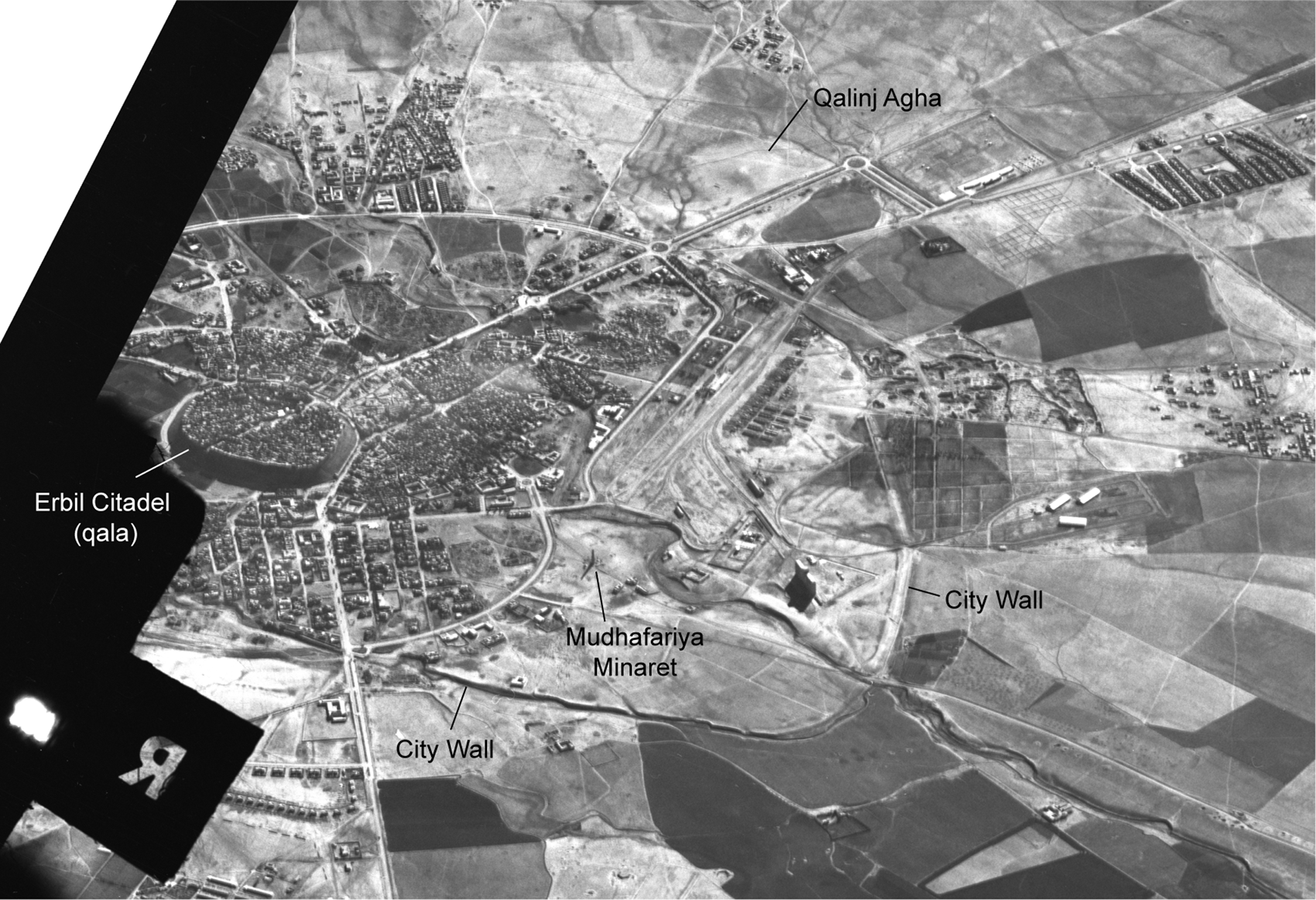
Fig. 2 An oblique view of the city of Erbil photographed by a U2 plane on 29 January 1960 (Mission 1554).
The most transformative new imagery source has been UAV (Unmanned Aerial Vehicle, or drone) photogrammetry. Since 2016, EPAS has employed a series of devices. The workhorse has been the DJI Phantom 4 quadcopter, which has provided the majority of the project's vertical photography. The project has also employed a DJI Mavic Pro quadcopter for taking oblique photos for basic documentation. These commercial drones have batteries capable of 15-minute flight times and can be used with mission planning software (such as Drone Deploy and DJI Go) to acquire imagery with sufficient overlap for 2–3 cm orthophotos of all but the largest archaeological sites. In 2018, EPAS acquired a senseFly eBee Plus, a fixed-wing drone capable of 50-minute flight times under typical conditions. Unlike the DJI quadcopter devices, the eBee has an on-board GNSS (GPS) receiver that allows for post-processing correction of its positions, routinely to an error of less than 10 cm.
The historical imagery sources are tools for preliminary site location, whereas the drone program has become a baseline tool for site mapping. The drone program records surface conditions and features (via orthoimagery of <5 cm spatial resolution) and creates topographic maps (via digital surface models of <10 cm spatial resolution) for all identified sites and landscape features on the plain. It maps not only the horizontal extent of all sites (in square meters or hectares) but also assesses mound heights precisely and makes volumetric calculations possible. Given the multi-period occupational history of nearly all sites on the plain, an accurate measurement of mound volume stands as an important metric for spatial analysis that was previously unobtainable with any degree of accuracy.
The availability and ease of use of these UAV devices has been nothing short of revolutionary for archaeological survey methods (Olson and Rouse Reference Olson and Rouse2018). Drones are now a basic element of the EPAS field collection protocol. Under normal circumstances, each site is mapped and collected in a three-day cycle by two separate teams (see Ur and Blossom Reference Ur, Blossom, Wright and Harder2019: 162). On the first day, the drone team visits a series of potential sites identified from CORONA, HEXAGON, or U2 photographs.Footnote 4 Each is photographed from a height of 75–120 meters, depending on its area and the scale of noteworthy surface features. Flights are planned as parallel transects with photographs taken at spaced intervals with a minimum of 60% overlap (Fig. 3). These transect-based flights are entirely automated through the DroneDeploy or DJI GS Pro mobile apps (for the DJI quadcopter) or the senseFly eMotion 3 PC application (for the eBee Plus fixed-wing UAV). For high mounds, these transects can be supplemented with 45° oblique photographs taken toward the site centre. Oblique photographs improve the terrain results of photogrammetric models. For flights using the Phantom 4, one drone team member records 3D GNSS positions on distinctive ground features to serve as ground control during the photogrammetry process. We initially used pre-printed targets, but quickly concluded that the refuse-rich nature of the Erbil landscape provided abundant preexisting ground control points in the form of plastic bags, cardboard packaging, and other high-contrast debris. Using these methods, the drone team can fly between five and ten sites per day.

Fig. 3 UAV (drone) flight planning over Site 282 Girdi Abdulaziz. Points represent the positions of drone photographs, at roughly 100 m intervals. See http://arcg.is/1y4TjL for an interactive 3D web scene.
In the afternoon of the first day, images are downloaded onto a field laptop customized for graphics processing. The positions of the images from the eBee Plus are post-processed with reference to the Continuously-Operating Reference Station (CORS) based in Erbil.Footnote 5 Vertical photographs for each mission are brought into either Agisoft Photoscan (in the 2016 season) or ESRI Drone2Map (2017 to 2020 seasons) photogrammetry software.Footnote 6 Even with specialized hardware, photogrammetric modeling is a time-consuming process, so the models of the day's sites are run overnight, and often well into the next day.
On the second day, the resulting orthophotos and digital surface models are viewed and analyzed. The high-resolution topography from the surface models is used to plan the collection strategies for the sites flown by the drone team on the previous day. For large or topographically complex sites, collection areas could be pre-defined as discrete polygons with reference to site mounding and current ground visibility conditions. These collection polygons and all other spatial data are edited locally but hosted “in the cloud” using ESRI's ArcGIS Online platform.
On the third day, the collection team visits the sites flown by the drone team two days earlier. Collection team members are equipped with iOS and Android mobile devices running the ArcGIS Explorer and ArcGIS Collector apps and using Bluetooth-enabled GNSS (GPS) receivers (Trimble R1 and Garmin GLO devices). All team members therefore have full access to the project's entire spatial database, including the data for the day's sites. Data collected or modified by any one team member is visible to the rest of the team via the cloud. For most of the Erbil Plain, cellular data is accessible and reliable, and new data is shared in real time; for areas remote from the city of Erbil, it is occasionally necessary to download the data for offline use, and to sync the day's collection once the team returns to Erbil.
The project's drone-based field protocol has proven to be efficient and reliable. Since 2016, the drone program has collected almost 152,000 images in 339 planned missions. The resulting spatial datasets cover more than 10,000 hectares (or over 100 square kilometers) and include 401 (55%) of the project's 728 sites identified to date.
General Results: The Archaeological Landscape of the Erbil Plain
Between 2012 and 2020, EPAS conducted seven field seasons.Footnote 7 In 2014–2015, the Directorate of Antiquities advised the project to delay until the conflict with ISIS/Da'esh was pushed further away from the survey region. Since then, the project has conducted annual survey seasons from late August to early October. Before and during these field seasons, the project identified 1,956 potential sites and visited 1,142 (58%) of them; 728 were confirmed to be archaeological and 414 were deemed to be non-sites (“false positives” in remote sensing terminology). Most of our identifications come from the CORONA 1039 mission (461 sites, 78% of all sites confirmed through 2018). Only 66 sites (9%) were initially documented in the field without previous remote sensing identification. These field-identified sites are almost entirely small and low and were identified from vehicles or by surveyors walking between other sites and potential sites. Transect walking is not a part of the EPAS field methodology during this first phase of fieldwork.
The EPAS contract covers 3200 km2 around Erbil (Fig. 4). To date, most of the team's investigations have focused on the broad alluvial plain south and west of the city of Erbil, which is included in the districts (nahiyas) of Gwer, Shamamok, and Qushtapa. Overall, site density in this 730 square kilometer zone is high by the standards of surveys elsewhere in greater Mesopotamia: 0.65 sites/km2. This figure could be as high as 0.93 sites/km2 once all remaining potential sites in this region have been visited.Footnote 8

Fig. 4 The EPAS region, with confirmed and potential sites and premodern canals indicated.
Site density fluctuates within the survey region (Fig. 5). Highest is Gwer nahiya, where density averages 0.97 sites/km2 and was often well more than that figure along the lower Siwasor River. Surveyed parts of Qushtapa nahiya have the lowest site density at 0.52 sites/km2, and Shamamok is intermediate at 0.72 sites/km2. These density figures are equivalent to or well in excess of the standard site densities recorded by recent high-intensity surveys elsewhere in northern Mesopotamia, which tend to find sites at a rate of 0.4–0.5 sites/km2. This lower range includes the Hamoukar Survey in a similar landscape in northeastern Syria, which used a nearly identical site identification method (Ur Reference Ur2010b). Site density on the Erbil Plain is dramatically higher than the recovery rates for the classic surveys of the southern Mesopotamian plain (e.g., Adams Reference Adams1981), which recovered sites at a density of 0.1 to 0.2 sites/km2. Adams and his colleagues did not have access to high resolution satellite photography or GPS and GIS technology, and it will be interesting to see what the use of these survey tools will do to recovery rates on the southern Mesopotamian plain.

Fig. 5 Density of sites per square kilometer in Gwer, Shamamok, and Qushtapa nahiyas, Erbil Plain, in areas surveyed 2012–2018. See web map at http://arcg.is/qyqCi.
The overall density of settled area (settled hectares per km2), is also variable (Fig. 6). When combined, the surveyed regions of Gwer, Shamamok, and Qushtapa nahiyas show a ratio of 3.75 settled ha/km2. Gwer and Shamamok show higher ratios (4.40 and 4.34 ha/km2, respectively) than does Qushtapa at 2.71 ha/km2. Within the nahiyas there are hotspots of durable urbanisation, most prominently in central and southern Shamamok, which was the locus of large settlements from the third millennium b.c. until the Islamic period.

Fig. 6 Hectares of archaeological sites (settled hectares) per square kilometer in Gwer, Shamamok, and Qushtapa nahiyas, Erbil Plain, in areas surveyed 2012–2018. See web map at http://arcg.is/0HGH0z.
The survey has also investigated other subregions of the survey area. In the short 2018 field season, the team surveyed 150 km2 north and east of the town of Khabat, to the northwest of Erbil (see Fig. 4). This area is characterized by undulating hills and left-bank Upper Zab tributary wadis. It presented a greater challenge to the project's remote-sensing based site identification methods than did the flat alluvial plains of Gwer and Shamamok. CORONA-identified features were confirmed as archaeological sites only 59% of the time, compared to 70% for the southwestern region of the survey. Sites in this region tend to be smaller than those of the Gwer and Shamamok nahiyas, and to occur at a much lower density (only 0.33 sites/km2, but possibly as high as 0.58 sites/km2 once the remaining potential sites have been visited).
Finally, the team has made opportunistic visits to areas north of Erbil in pursuit of the subterranean canal commissioned by Sennacherib to run from the Bastora Chai to the Assyrian provincial capital at Arbail (under modern Erbil). Since 2016, the project's work in this region has been limited to drone mapping, but with surprising results (described below). The site location, collection, and analysis done to date allows a preliminary description of the plain's settlement history (Fig. 7), to be described in detail in the following sections.

Fig. 7 Histogram of settlement evolution on the Erbil Plain. Bars represent the number of sites for each period (left Y-axis). Line represents the total settled area in hectares (right Y-axis).
Late Neolithic to Late Chalcolithic 1–2 Settlement
Given its position and natural resources, there is every reason to believe that hominins inhabited the Erbil region in the Paleolithic, but very little evidence exists from the plain itself at present. Our ignorance stems from a combination of taphonomic factors and choices about survey methodology. The central part of the plain has been cultivated since the Neolithic and intensively irrigated for the last few millennia; any Paleolithic campsites would long ago have been removed or buried under colluvium. In any case, the project's field methods are not designed to find ephemeral sites; appropriate methods have been developed and applied to Mesopotamian landscapes (see, e.g., Hammer and Ur Reference Hammer and Ur2019), but they are unsuitable for the landscapes of urban empires, which is the project's focus in its present phase. In future seasons, the project intends to intensify while moving into the low rocky hills at the southern and eastern fringes of the project, and onto the low Demir Dagh hills west of Erbil. These areas are still largely uncultivated and therefore more likely to preserve early non-sedentary landscape features.
Site 44, the earliest site recovered by the project, is a 2-ha low mound 200 m north of the Siwasor in the centre of the plain. It featured a low scatter of coarse chaff tempered handmade body sherds and lithics, including points. Some of its height may be due to an Ottoman-era settlement atop it. At present it is endangered by soil excavation, which has hollowed out its centre. It is likely that there were other contemporary sites on the plain, but if they were of similar size and surface material abundance, they would be easily obscured beneath later mounds.
Durable settlement patterns can be described starting with the Hassuna (Period 1), Halaf (Period 2), Ubaid (Period 3), and LC 1–2 (Period 4) periods. Sites are small, with median sizes between 1–2 ha. Settlement numbers were low throughout, fluctuating between 19 and 26. Nonetheless, there are a few larger outliers. Girdi Daghan (Site 228) is a double mound with a broad lower town; its Hassuna component may have exceeded 6 ha. For the Halaf, three sites exceed five ha. Site 407 features dense scatters over almost 9 ha. Site 227 is a broad low mound with a 6.6 ha Halaf scatter. Site 338 might have been as large as ten hectares, but this figure is likely to be an overestimate. During the Ubaid, four sites exceeded five hectares: 272 (Girdi Helawa, see Peyronel and Vacca Reference Peyronel and Vacca2015), 275, 354, and 364. The latter two may also be overestimations, but Site 275 is a double mound with abundant surface artifacts that can be confidently measured at 6 hectares.
True nucleation appeared during the LC 1–2, when Site 466 (Girdi Gozka) may have grown to 19 ha. The LC 1–2 period is perhaps the best-researched on the plain (see Peyronel and Vacca Reference Peyronel and Vacca2015 for a recent review), starting with the excavations at Qalinj Agha (Abu al-Soof Reference Abu Al-Soof1969) and with new excavations at Surezha (Site 27; Stein et al. Reference Stein, Fisher, Yashmi, Harris, Erkesuz, Babour, Wilson, Proctor, Alden, Minc and Varoutsikos2018), Helawa (Site 272; Peyronel and Vacca Reference Peyronel and Vacca2015), and Nader (Site 5; Kopanias et al. Reference Kopanias, Beuger, Carter, Fox, Hadjikoumis, Kourtessi-Philippakis, Livarda and Macginnis2013).
These Late Neolithic and Chalcolithic sites are not evenly distributed on the plain. They concentrate in central Shamamok nahiya, along the upper reaches of tributaries of the Kurdara Chai. Despite the overall density of sites in Gwer nahiya (see Fig. 5), sites of the Hassuna through Ubaid periods are almost entirely absent from the lower Erbil plain. It is unlikely that this situation stems from a true absence of settlement, however. The lower reaches of the Siwasor Chai and Kurdara Chai were heavily irrigated starting at least in the Neo-Assyrian period, and the village-based karez system of subterranean canals may have also watered this district. The earliest settlements in Gwer are likely to have been obscured or deliberately removed by these works.
These early sites also hint at environmental change since the mid-Holocene. Several of these sites, including some of the largest (e.g., Site 228 Girdi Daghan, and the cluster of prehistoric sites around Site 74), are far away from major wadis at present. Higher humidity, in the form of more abundant rainfall and less seasonality, may have allowed human communities to thrive without proximity to surface water sources. On the other hand, it is also possible that wadi courses have changed over the millennia; these early sites may mark the positions of earlier watercourses. A definitive answer must await the results of the project's geomorphology program, which began in earnest in 2019.
Notably absent thus far are any signs of the incipient urbanisation known from the LC 1–2 period in northeastern Syria, for example the low-density agglomeration at Khirbat al-Fakhar or the non-nucleated urban form at Tell Brak (Ur Reference Ur2010a: 394–395).
The Fourth Millennium b.c. and the “Uruk Expansion”
In the fourth millennium b.c., settlement on the plain began to develop in an unexpected manner. Elsewhere in northern Mesopotamia, in the standard “LC” ceramic sequence, the pottery of the LC 1 and LC 2 periods evolved from clear Ubaid antecedents, with some technical innovations; this tradition was continued into the LC 3 and LC 4 periods, with new forms having clear predecessors. In other words, stylistic and technical changes were gradual and suggested a smooth endogenous evolution, until the appearance of radically different forms and manufacturing traditions best known from southern Iraq generally and the site of Uruk in particular. Ceramics of the Uruk tradition first appear stratified with pottery of the LC 4 “local” tradition in the LC 4 period; by the LC 5 period, it appears that only the wares of the Uruk tradition were still being manufactured. The social processes behind these ceramic changes are still debated (Algaze Reference Algaze1989, Reference Algaze2005; Stein Reference Stein1999). Settlement patterns are implicated heavily in most assessments of the period.
The fourth millennium b.c settlement pattern of Erbil deviates dramatically from this northern Mesopotamian narrative, with implications for our understanding of the Uruk phenomenon. Pottery of the LC 3–4 tradition (Period 5b) is almost entirely absent from sites on the plain. The survey has analyzed nearly 61,000 sherds since 2012 and has classified over 14,000 of them according to the project's survey ceramic typology. Only 44 sherds can be unambiguously assigned to the LC 3–4 periods, compared to 402 for the LC 1–2 period. The most common LC 3–4 types in the Jazira are exceedingly rare around Erbil: casseroles (T5b/5, four examples), hammerhead bowls (T5b/4, one example), and internally hollowed jar rims (T5b/1, three examples). These types dominated the surface assemblages of fourth millennium b.c. sites in the surveys of the Tell Brak lower town and the Hamoukar region (Ur Reference Ur2010b: 240–246). Some settlement of the LC 3 has been reported from Helawa (Peyronel and Vacca Reference Peyronel and Vacca2015), but elsewhere on the plain, these types are very uncommon.
On the other hand, the grit-tempered types of the southern Mesopotamian Uruk tradition (Period 5a) are common, far more so than in published Jazira surveys or in neighboring areas of the Kurdistan Region. Beveled rim bowls (372 examples) make up 55% of all Uruk types; thus, nearly half of the total assemblage is comprised of the well-fired grit-tempered types that are generally interpreted to signify Uruk colonies or enclave-type settlements. In the collections thus far, there are sixteen times more Uruk diagnostics than there are LC 3–4 types.
Uruk sites are abundant (n = 47) and cover the entire surveyed plain evenly (Fig. 8). In general, they are no larger than the sites of earlier periods and on average slightly smaller (mean size of 2.46 ha). Several sites exceed 5 ha. Girdi Gozka (Site 466) is a broad low mound with an Uruk scatter estimated at 8 ha, and with two outlying sites (464 and 465) that are probably associated. It has a circular shape on 1967 CORONA imagery that suggests possible circumvallation (Fig. 9). It is rapidly being covered by a modern village, and its northern edge has been damaged by mechanical excavation for terracing. Gozka is also a substantial LC 1–2 site, probably even larger than in the Uruk period. Girdi Khazna (Site 45) is another large Uruk site where scatters cover an estimated 7.6 ha. This site is upstream from Qasr Shemamok on the Siwasor Chai, which has eroded a substantial portion of its south face (Fig. 10). There are other sites that could potentially be large Uruk settlements; Surezha (Site 27) had a small Uruk settlement on its central mound, but there are scatters found in its large lower town, which has not yet been formally collected.

Fig. 8 Settlement pattern of Period 05a southern Uruk.

Fig. 9 KH9 HEXAGON satellite photograph of Site 466 Gozka (Mission 1202, 1 February 1972). Web map at http://arcg.is/1W1Oq1.

Fig. 10 Oblique UAV photograph of Site 45 Khazna showing erosion by the Siwasor River. See http://arcg.is/f9C8z for an interactive 3D web scene.
The Uruk landscape of Erbil is remarkable, especially when compared to contemporary landscapes (Fig. 11). The “Heartland of Cities” surveys in southern Mesopotamia (Adams Reference Adams1981; Adams and Nissen Reference Adams and Nissen1972) included 357 Late Uruk sites and an additional 73 “trace” sites over a region of approximately 7,286 km2. For comparative purposes, therefore, site density in the Uruk and Nippur regions is 0.059 sites/km2. The surveyed Gwer-Shamamok-Qushtapa region of EPAS has a nearly identical site density of 0.064 sites/km2 (47 sites over 730 km2). Elsewhere in northern Mesopotamia, Uruk site densities can be nearly as high: 0.050/km2 around Hamoukar and 0.040/km2 in the Tell al-Hawa region (Ur Reference Ur2010b; Wilkinson and Tucker Reference Wilkinson and Tucker1995). Unlike the Erbil Plain, however, the sites in these latter regions are almost always characterized by a mixture of southern Uruk and local LC ceramic types.

Fig. 11 Comparative densities of Uruk sites in selected Mesopotamian surveys (comparative data from Adams Reference Adams1981; Ur Reference Ur2010b; Wilkinson and Tucker Reference Wilkinson and Tucker1995).
On the other hand, Uruk ceramics are nearly absent from the surrounding regions to the north and east of the Erbil Plain. The survey of the Cizre-Silopi plain identified only two sites with an Uruk presence (Algaze et al. Reference Algaze, Hammer, Parker, Breuninger and Knudstad2012: 19). In the Zakho Region, surveyors state that in the initial 2013 season, “almost no Uruk-related pottery was identified” (Pfälzner et al. Reference Pfälzner, Sconzo and Puljiz2015: 110). The area of the Land of Nineveh Project, including the Navkur Plain, had produced only three Uruk potsherds through that project's first two seasons, but a full complement of chaff-tempered LC 3–4 types (Morandi Bonacossi and Iamoni Reference Morandi Bonacossi and and M2015: 21; Gavagnin et al. Reference Gavagnin, Iamoni and Palermo2016: 130–132). To the north of Erbil, the Upper Greater Zab Archaeological Reconnaissance has identified five sites with Uruk material (one site exclusively with Uruk types), all of which are within 10 km of the EPAS survey limits (Koliński Reference Koliński, Horejs, Schwall, Müller, Luciani, Ritter, Giudetti, Salisbury, Höflmayer and Bürge2018: 17, fig. 2). On the Raniya and Peshdar Plains to the northeast, the Soulaimaniah Governorate Archaeological Survey has identified four small sites with Uruk material, but there are no sites with entirely Uruk assemblages (Giraud et al. Reference Giraud, Baldi, Bonilauri, Mashkour, Lemée, Pichon, Mura, Pot, Jamialahmadi, Biglari, Caze, Louchet, Havé, Douché, Ameen, Raeuf, Saber, Al-Debs, Sofy, Jameel, Walika and Rahem2019).
The Uruk settlement pattern on the Erbil Plain, and its comparison with other regions, suggests that the plain was not a part of the “Uruk Expansion”—instead it may have been part of the “core,” if these terms continue to be meaningful. The density of sites, and their purely Uruk ceramic composition, are nearly indistinguishable from that of the plains of southern Mesopotamia. The absence of LC 3–4 style pottery on the Erbil plain might suggest that it was abandoned prior to an Uruk “intrusion,” but it might also suggest a very early appearance of Uruk influence and/or people, analogous to (and perhaps contemporary with) the expansion from the southern plains into Susiana/Khuzistan (Algaze Reference Algaze2005: 110–112). The Erbil Plain thus was an early and well-integrated part of the Uruk world and probably its northernmost extension. New results from the Chemchamal area (Vallet et al. Reference Vallet, Baldi, Naccaro, Rasheed, Saber and Hamarasheed2018) support this geographic reassessment. The sensational archaeological discoveries on the Euphrates, especially in the Tabqa Dam reservoir zone, have deceived scholars into concluding that the Euphrates was the axis of the expansion; the evidence from Erbil, Chamchamal, the North Jazira, and the Hamoukar region points to a Tigris/Zagros piedmont trajectory northward, and a turn to the west beyond Erbil.
The Early Bronze Age
The start of the third millennium b.c. was a time of transition. The number of settlements on the plain remained stable, with a slight (10%) reduction from 47 to 44 in the Ninevite 5 Period (Period 6). However, the small reduction in numbers came with a dramatic (43%) reduction in the total settled area. Villages were, on average, much smaller than in the preceding Uruk period. Whether this was the result of demographic reduction or simply nucleation remains to be determined; there is an argument to be made for the latter from the Jazira, where Ninevite 5 villages could be very densely packed with housing (see, e.g., Tell al-Raqa'i, Schwartz Reference Schwartz2015). It is also possible that Ninevite 5 sites have been under-estimated because they are the basal layers of long-lived mound sites, a pattern also known from the Jazira.
The decorated diagnostic types found on Erbil Plain Ninevite 5 sites are overwhelmingly the painted variety; they make up 38% of the 568 Ninevite 5 sherds collected, compared to 9% for the incised variety. This situation is the inverse of that seen in the adjacent region of Dohuk (Gavagnin et al. Reference Gavagnin, Iamoni and Palermo2016: 132–134). Whether this difference is regional or chronological remains to be determined.
Overall, the early third millennium b.c. was a time of scattered small villages. It marks a dramatic break from the situation in the fourth millennium b.c., when its settlement landscape was similar to the southern Mesopotamian plains in settlement density and in ceramic culture. The Ninevite 5 pattern was similar to the patterns seen in the Jazira to the west and strikingly different from the hyper-urbanisation of the south.
In the later EBA (Period 7, mid to late third millennium b.c.), the plain again displayed patterns known elsewhere in northern Mesopotamia: strongly mound-based settlement with close connections to major watercourses and wadis, a handful of which grew to urban scale comparable to the towns and cities of the contemporary Jazira. From historical attestations, it might be assumed that Erbil (Urbilum) was a large settlement at this time, but its size cannot be determined archaeologically. At the top of the hierarchy is 80-ha Girdi Baqrta (Site 17; see Ur et al. Reference Ur, De Jong, Giraud, Osborne and Macginnis2013: 97–98 and fig. 5; Kopanias et al. Reference Kopanias, Beuger, Macginnis, Ur, MacGinnis, Wicke and Greenfield2016), which has a high mound and lower town morphology that fits well with other sites of this time.
The morphology of Site 33 (55 ha) is unique on the plain: a series of low and seemingly discrete mounds stretched along the left bank of the Siwasor Chai. It was initially collected as several separate sites (Sites 33–37 and Site 87), which were later revealed all to have later EBA and MBA diagnostics (Ur et al. Reference Ur, De Jong, Giraud, Osborne and Macginnis2013: 98–99). In all probability, the Siwasor has removed a portion of its eastern extent, and it may have originally exceeded 60 ha.
Site 220 Tell Quri Beg also has a distinct morphology (Fig. 12). Its high mound has an unusual undulating topography that hints at recent excavation, although the project's earliest imagery (a January 1960 U2 photograph) already shows this signature. The site was flagged as significant because of its appearance on CORONA imagery, in which it was bounded to the north by an indistinct curving line that was hypothesized to be a wall or ditch. Surface collections revealed that both mound and this northern area contained abundant later third millennium b.c. pottery, as did a flat area to the east (collected as Site 221). Drone-derived terrain data appears to confirm the presence of a wall.

Fig. 12 The complex of sites around Site 220 Tell Quri Beg and a vertically exaggerated elevation profile across it. Drone-derived terrain data from January 2019.
The later EBA settlement landscape is generally similar to the well-surveyed Jazira, but the off-site landscape shows significant differences. Most notably, the dense landscape of radial tracks (“hollow ways”) in the Jazira (Ur Reference Ur2003; Reference Ur2010b: 129–146) does not appear with the same clarity on the Erbil Plain. Isolated track features can be recognized, but they are not strongly associated with major EBA mounds as in the Jazira; to the contrary, they seem more connected to MBA sites (see below). Overall, their patterning is probably related to survival: they are nearly absent in the central plain, which was heavily irrigated, and are abundant in the eastern areas that have few traces of canals. A similar pattern of destruction was identified in the Upper Khabur basin, where a medieval irrigation system below Nisibis appears to have removed most archaeological trackways (Ur Reference Ur2010b, in press). This taphonomic issue is discussed in greater detail below.
Site numbers increased slightly, from 44 to 48, from the preceding Ninevite 5 period. The mid-to-late third millennium b.c. was the start of an age of steady growth in settlements and population, measured by site numbers and aggregate site area respectively, that continued for a millennium and a half, until the early first millennium b.c. (see Fig. 7). It is not yet possible to subdivide this period chronologically into historically defined phases (e.g., Early Dynastic III, Akkadian, Ur III, etc.) on the basis of the ceramic assemblage. The pottery traditions seem to look more to the south than to the Jazira; there are more similarities to Ashur (Beuger Reference Beuger2005) than to published assemblages from Tell Brak (Oates et al. Reference Oates, Oates and McDonald2001) or Hamoukar (Colantoni and Ur Reference Colantoni and Ur2011).
The Middle and Late Bronze Ages
With the beginning of the second millennium b.c., it becomes possible to connect the archaeological settlement patterns with historical events from contemporary cuneiform texts. The political scene in northern Mesopotamia was dominated by conflicts between tribes and kingdoms, as reconstructed from texts of Mari, Tell al-Rimah, and Shemshara (Ziegler Reference Ziegler2000; Charpin Reference Charpin2004). The Kurdistan Region was located between Ešnunna to the east, led by its king Daduša, and Samsi-Addu's kingdom in the west. Their relationship fluctuated between hostility and alliance, and the region was also always under threat from the Guti and the Elamites. To consolidate his rule, Samsi-Addu allied at times with small local kingdoms and at other times attempted to subjugate them. A good example is his relationship with the Turukkeans, as Shemshara texts show; he attempted to make a semi-alliance with one of their leaders, Kuwari, and with other Turukkeans, but it was not enough to ward off their threat. The Turukkeans revolted under Lidaya in the Zab region, following a matrimonial alliance with the king of the Guti, Endušše. An alliance between Samsi-Addu, Ešnunna, and the Gutis was organized in the face of an alliance between Elam and the Turukkeans. This led Samsi-Addu to conquer the region in collaboration with Ešnunna.
The alliance between the kingdoms of Samsi-Addu and Daduša yielded results. It allowed Samsi-Addu to seize several cities in the eastern Tigris region, including Arrapha and Qabrā. According to a treaty, a clause provided for the division of spoils from Qabrā; Ešnunna took the spoils while the kingdom of Upper Mesopotamia seized its land. This suggests that Samsi-Addu had received Qabrā emptied of its inhabitants.
To this political history, we can add a vivid archaeological settlement record. In the Middle Bronze Age (Period 8), the Erbil Plain was the core of the kingdom of Qabrā, well known from the cuneiform texts of Mari (catalogued in MacGinnis Reference MacGinnis2013b) and a victory monument of Daduša of Ešnunna, which includes a representation of the city and its wall (Rollinger Reference Rollinger2017: fig. 1). The position of its eponymous capital city has been the source of much speculation, but it has generally been placed in the southern Erbil Plain (Eidem Reference Eidem1985: 84; Deller Reference Deller1990). The EPAS project identified Kurd Qaburstan (Site 31) as a likely candidate for this lost capital on CORONA imagery and confirmed its wall and its MBA date via field survey in August 2012 (Ur et al. Reference Ur, De Jong, Giraud, Osborne and Macginnis2013: 99–100). Excavations and geophysical survey by Johns Hopkins University have confirmed the survey dating and revealed the city wall and its bastions in striking detail (Schwartz et al. Reference Schwartz, Brinker, Creekmore, Feldman, Smith and Weber2017).
At 100 ha, Kurd Qaburstan sat at the top of an expanded settlement landscape, which included 54% more sites than in the late third millennium b.c., encompassing 20% more settled area (Fig. 13a). It was a transformed landscape; all major EBA cities and towns had declined in size. Girdi Baqrta shrank from 80 ha to perhaps 8 ha on its central high mound (Kopanias et al. Reference Kopanias, Beuger, Macginnis, Ur, MacGinnis, Wicke and Greenfield2016); the outer town of Site 220 was entirely abandoned; and most areas of the Site 33 complex were no longer settled. But many new villages emerged, and a handful of places grew. Aliawa (Site 246) includes a high mound and an extensive outer town that could have been as large as 25 ha in the MBA (Fig. 14). The 8.1-ha prominent mound at Girdi Abdulaziz (Site 282) was fully occupied in the MBA.Footnote 9 In several areas, settlements were strung along watercourses at even intervals, for example upstream from Aliawa.

Fig. 13 Settlement in Gwer, Shamamok, and Qushtapa nahiyas, in areas collected 2012–2018. A. MBA (Period 8); B. LBA (Period 10); C. Iron Age/Neo-Assyrian (Period 11).

Fig. 14 Site 246 Aliawa with surface collection areas indicated. Digital surface model derived from UAV photogrammetry.
As in the EBA, the MBA pottery traditions were related more to southern Mesopotamia than to the Jazira. For example, in the Hamoukar region, painted Khabur ware was 68% of the total surface assemblage, more than four times more frequent than any other MBA diagnostic type and, overall, the single most common type for any period (Ur Reference Ur2010b: 264). Khabur ware appears to be equally common in the Navkur Plain and areas north of Mosul (Gavagnin et al. Reference Gavagnin, Iamoni and Palermo2016: 138–140). Khabur Ware comprises, however, only 12% of the EPAS MBA collections.
The transition to the Late Bronze Age (Period 10) appears to have been characterized by overall continuity (Fig. 13b). Settlement continued the trends in growth of site numbers and settled area that had been underway for a millennium. Yet again there was growth in site numbers (by 28%, to 95 sites) but a more restrained growth in settled area (17%). The urban centre shifted to Qasr Shemamok (Site 2, ancient Kilizu), a 50-ha walled citadel and lower town on the Siwasor Chai, intermediate between Erbil and Nimrud and the subject of French-led excavations (Masetti-Rouault Reference Masetti-Rouault2017). Although the site has not been formally collected, opportunistic observations over one week in the 2011 season (Rouault et al. Reference Rouault, Masetti-Rouault, Calini, Macginnis, Ur, Vitale, Déroche, Masetti-Rouault and Nicolle2018: 241–245) hinted at substantial extramural activities that might include brickmaking and habitation.
Other towns flourished, particularly at already-established settlements. Several older cities were repopulated, but not to their former extents: Baqrta (Site 17) expanded to almost 30 ha, while Kurd Qaburstan (Site 31) measured 20 ha. Aliawa (Site 246) maintained a 20-ha size. Six other sites grew to 10 ha or more, including the 20-ha Girdi Qawagh (Site 180). Overall, the LBA settlement expansion was characterized by an urban redistribution (fewer smaller cities and towns) and the appearance of more rural villages. This trend would continue into the first millennium b.c.
The pottery manufacturing traditions of the MBA transitioned smoothly into the LBA. As a result, EPAS has not made an attempt to subdivide the LBA into politically-defined chronological subdivisions such as “Mitanni” and “Middle Assyrian,” since it is certain that potters did not adjust their techniques on the occasion of the shifts in political power (Ur Reference Ur2010b: 267).
The Erbil Plain under the Neo-Assyrian Empire
The early Iron Age is not yet identifiable in surface ceramics, but by the early first millennium b.c., the Erbil Plain flourished as part of the core of the Neo-Assyrian empire. In fact, much of the EPAS region could be said to be the “Land Behind Nimrud;” the western part of the plain is closer to Nimrud than it is to Erbil (see Fig. 1). The plain was variously part of the provinces of Arbail and Kilizu (Radner Reference Radner2006).
The most important city, and probably also the largest, was of course Arbil itself, today almost entirely beneath the modern city of Erbil, capital of the Kurdistan Region of Iraq. The city held great political and religious importance and is best known from texts (MacGinnis Reference MacGinnis2013a), although recently there have been studies of historical remote sensing sources (Nováček et al. Reference Nováček, Amin and Melčák2013), surface collections of its citadel (Nováček Reference Nováček2008), and various investigations into its outer town (van Ess et al. Reference Van Ess, Hausleiter, Hussein, Mohammed, Petiti and Tourtet2012; Hausleiter and Van Ess Reference Hausleiter and Van Ess2016). Kilizu (Site 2, modern Qasr Shemamok) remained a provincial capital, home to a palace of Sennacherib known from brick inscriptions. It was briefly sounded in the 1930s (Furlani Reference Furlani1934a; Anastasio et al. Reference Anastasio, Conti and Ulivieri2012) and has been excavated by a French team since 2011 (Masetti-Rouault Reference Masetti-Rouault2017; Rouault Reference Rouault, MacGinnis, Wicke and Greenfield2016).
It is now possible to connect these cities with their rural hinterlands (Fig. 13c). Neo-Assyrian (Period 11) site numbers grew yet again, showing a 36% increase over the LBA. At the same time, the total settled area slightly declined from the LBA by 6%. Qasr Shemamok retained its urban stature, but elsewhere towns declined in size; for example, the 27.8 ha LBA town at Baqrta (Site 17) was reduced to 7.8 ha on its citadel, and the 21 ha LBA town at Kurd Qaburstan (Site 31) declined to a 5.3 ha village. Overall, it appears that mid-sized settlements were replaced by smaller villages and hamlets.
The increase in site numbers seems to have been less dramatic than reported earlier (Ur et al. Reference Ur, De Jong, Giraud, Osborne and Macginnis2013: 102; Ur and Osborne Reference Ur, Osborne, MacGinnis, Wicke and Greenfield2016: 170). These earlier reports (seasons 2012–2013) described Gwer and western Shamamok nahiyas; recent seasons in eastern Shamamok and Qushtepe nahiyas have revealed substantial settlement variability across the plan, especially in the LBA and Neo-Assyrian periods. For one, LBA settlement was substantial in these latter districts, especially near the plain's watershed between the Upper and Lower Zab Rivers. In the first millennium b.c., growth occurred in Gwer nahiya. Gwer was the focus of Neo-Assyrian canal construction (see below), which may explain the shifted settlement focus.
Many small Neo-Assyrian sites are dissociated from watercourses, especially in the hinterland of Qasr Shemamok and in Gwer nahiya. In earlier prehistoric periods, a similar dissociation might be explained by a more humid climate (e.g., Sinha et al. Reference Sinha, Kathayat, Weiss, Li, Cheng, Reuter, Schneider, Berkelhammer, Adalı, Stott and Edwards2019) or by a different pattern of surface drainage that is no longer apparent. In the case of the Neo-Assyrian period, it appears that settlements were placed deliberately into these agriculturally marginal spaces to expand agricultural productivity. It is also possible that these newly settled areas were not as marginal as they might appear. The Neo-Assyrian period witnessed tremendous imperial investment in the water management infrastructure throughout the empire, including the core areas (Kühne Reference Kühne2018; Morandi Bonacossi Reference Morandi Bonacossi and Kühne2018; Ur Reference Ur2005; Ur and Reade Reference Ur and Reade2015). The plain likely saw Neo-Assyrian era construction in three major zones, discussed below.
Hellenistic to Parthian Erbil Plain
After the end of the Assyrian Empire and the archaeologically elusive Achaemenid period, the plain of Erbil fell under the political control of the Seleucid kings (late fourth–late second c. b.c.). As in the Neo-Assyrian period, the most important city was Erbil itself, renamed Alexandria Arbela in consequence of the symbolic re-foundation by Alexander the Great, in the aftermath of the battle of Gaugamela (Cohen Reference Cohen2013: 117). Besides literary and numismatic evidence, little was known, archaeologically, for this period in the region. EPAS data collection, as well as evidence from other projects (Morandi Bonacossi and Iamoni Reference Morandi Bonacossi and and M2015; Palermo Reference Palermo, Kopanias and MacGinnis2016) are enabling a new interpretation of the Seleucid period in the entire area (a detailed discussion will appear in Palermo et al. Reference Palermo, De Jong and Urunder review).
The Hellenistic period (Period 13) showed site numbers decreasing by 35% and the aggregate settled area decreasing by 43%, compared to the Neo-Assyrian period. Such variation is certainly due to the loss of centrality of the Erbil plain under the Seleucids, when the imperial core moved south to Babylonia (Kosmin Reference Kosmin2014). The decrease testifies to a partial re-organization of the former Assyrian core within the vast Seleucid territory.
The 83 Seleucid sites are evenly distributed in the investigated area, with some of them aligned along reliable sources of water. Others occupy agriculturally marginal zones, following a similar pattern already observed for the Neo-Assyrian period. Denser clusters of Hellenistic sites have been recorded in Gwer and Qushtapa nahiyas. In the former, the site of Tell Abu Shita was the largest centre. Other major Hellenistic settlements have been identified at Site 6 Girdi Matraba (10 ha) in the nahiya of Shemamok and at Site 404 Girdi Peshka (almost 16 ha) in the nahiya of Qushtapa.
The plain's settlement recovery continued into the Parthian phase (Period 14, late second c. b.c.– early third c. a.d.), and in fact this was a time of major urbanisation in the plain of Erbil, one that can be compared with the Neo-Assyrian period in terms of site numbers and aggregate settled area (see Fig. 7). It is difficult to say whether this intense urbanisation was the result of a top-down intervention by Parthian rulers in the region, or an emergent (and thus bottom-up) process that started earlier during the Hellenistic period. In either case, the Parthian period occupation in the plain of Erbil is remarkable and aligns with data from other projects (Palermo Reference Palermo, Kopanias and MacGinnis2016; Pfälzner et al. Reference Pfälzner, Sconzo and Puljiz2015).
Parthian occupation has been recorded on 146 sites, an increase of 75% from the Hellenistic period. Total settled area exceeded 450 hectares, marking the most urbanised historical period in the plain of Erbil, with an increase of 134% from the preceding Hellenistic period, but also 33% greater than settlement of the Neo-Assyrian period, when the Erbil plain was the core of an empire. Excavations at Qasr Shemamok have shown that the former Assyrian provincial capital of Kilizu remained occupied in the Hellenistic and Parthian periods, although with settlement reduced to its 6-ha citadel (Rouault et al. Reference Rouault, Masetti-Rouault, Calini and Defendenti2014). Earlier explorations at the site also unearthed the remains of a Parthian period necropolis (Furlani Reference Furlani1934a, Reference Furlani1934b). Major Parthian sites are evenly distributed in the region, with a denser cluster of sites in the Qushtapa and Shemamok nahiyas. In Gwer, the large Hellenistic site of Tell Abu Shita (Site 130) expanded in the Parthian period to cover 48 hectares. Even larger was Girdi Baqrta (Site 17), a major urban centre of approximately 60 hectares in Period 14 (i.e., more than ten times the size of its Hellenistic settlement and six times larger than its Neo-Assyrian village). Parthian Girdi Baqrta was not the only urbanising settlement in its region; site 6 Girdi Matraba, a 10 ha Hellenistic town less than 2 km to the south, was not abandoned, but to the contrary, grew into a Parthian town of 18 hectares.
The Hellenistic and Parthian period occupations of the Erbil plain show a trend of recovery and re-urbanisation after the fall of Assyria. In the succession of large territorial empires in North Mesopotamia, a “landscape reboot” started at the end of the first millennium b.c. and continued, with variable characteristics, until the Sasanian period (Period 15). This trajectory differs from that of the contemporary Syrian-Iraqi Jazira (De Jong and Palermo Reference De Jong, Palermo, Stek and Düring2018; Palermo Reference Palermo2019; Ur et al. Reference Ur, De Jong, Giraud, Osborne and Macginnis2013; Wilkinson and Tucker Reference Wilkinson and Tucker1995), where the political and military confrontations between Rome and Parthia may have discouraged such dense landscapes of settlements.
Settlement in the late Sasanian Empire
The Sasanian empire was capable of massive landscape transformations in its core region of southern Mesopotamia (Adams Reference Adams, Marcus and Stanish2005; Wilkinson and Rayne Reference Wilkinson and Rayne2010) and its imperial fringes (Sauer et al. Reference Sauer, Wilkinson, Omrani Rekavandi and Nokandeh2013; Ur and Alizadeh Reference Ur and Alizadeh2013). The situation on the Erbil Plain, which was neither core nor periphery in the empire, is more ambiguous; its settlement landscape shows unique features, but they are not immediately attributable to the centralized decision making of an imperial power.
EPAS has used two categories to record Sasanian sites, following Wilkinson and Tucker (Reference Wilkinson and Tucker1995). The first (Period 15) is perhaps best thought of as containing ceramic types limited to the time of Sasanian control, including the distinctive stamped decoration (T15/3; see Ur Reference Ur2010b: 290). The second (Period 16) comprises types likely to have been used during the Sasanian empire and into the succeeding Early Islamic period. In the absence of reliable local ceramic sequences based on stratigraphic excavation, both “periods,” and indeed all that follow them, are based on surface assemblages of single-phase sites and are in desperate need of confirmation via excavation; indeed, much of what is designated here as late Sasanian may well date to the early centuries of the Islamic era (Nováček Reference Nováčekin press).
The late Sasanian landscape was dominated by spatially large but apparently low-density settlements. EPAS has already reported on one such site, Girdi Khazna (Site 45; Ur et al. Reference Ur, De Jong, Giraud, Osborne and Macginnis2013: 102–103), which was recognized in the first season of 2012. In subsequent seasons, several additional large sites were visited and dated to this same time period. Site 161 is a vast expanse of small low mounds and light artifact scatters covering 64 ha (Fig. 15). Zaga (Site 207) has the same morphology over 82 ha. Another site, Awena (Site 325) has not been formally collected, but Sasanian artifacts were observed during visits by the drone team. Girdi Baqrta (Site 17) was also large at this time, but perhaps because of its long earlier history (Kopanias et al. Reference Kopanias, Beuger, Macginnis, Ur, MacGinnis, Wicke and Greenfield2016), its morphology does not appear to match these dispersed sites.

Fig. 15 Low-density settlements of the late Sasanian period, in CORONA photographs (left, Mission 1039, 28 February 1967) and UAV-derived topographic hillside models (right). Top: Site 161; Middle: Site 207 Zaga; Bottom: Site 325 Awena.
If one were to judge them with reference to Bronze and Iron Age sites, these settlements would represent tremendous population aggregations. In fact, they probably represent a previously unsuspected low-density form of settlement. Their spatial signatures on CORONA and HEXAGON photographs show discrete areas of lighter soils (probably decayed mud brick architecture) with substantial darker areas in between. In high resolution digital terrain models, these light areas coincide with small low mounds (see Fig. 15). EPAS collections on these vast sites have been non-systematic out of necessity; full collection would consume several days for each and even longer for artifact processing. The project's opportunistic visits and collections do suggest, however, that these small mounds are characterized by relatively high artifact density, and the intervening spaces by low density or the absence of artifacts. None of these sites show any evidence for circumvallation.
It is difficult to interpret these sites. Their morphologies differ radically from the apparently dense towns and cities that preceded and followed them. It is not the spatial signature of settlements that were founded or grew within a pre-existing system of land tenure. In such cases, settlement tends to grow outward from nucleated villages, incorporating adjacent agricultural land first. The sprawling nature of these sites suggests colonization of areas previously uncultivated or reserved for pasture, yet several are located on prime agricultural land at the centre of the plain (e.g., Sites 45 and 207). It is likely that these settlements signify a major disruptive settlement transition on the plain, with the abandonment of preexisting land tenure systems and the introduction of new people with different ideas about town life. It has been proposed that these settlements may represent a new form of monastic settlement (Nováček and Wood Reference Nováček and Wood2020).
Most of the canal features on the plain are best dated to the Neo-Assyrian period, except for one very long feature originating within the village of Kawr Gosk and possibly stretching the full length of the Upper Zab River below it. This canal, likely to be Sasanian in date, is discussed below.
Islamic Settlement and Landscape
Settlement on the Erbil Plain in the Islamic period is challenging to describe with accuracy at present. EPAS continues to rely on ceramic indicators established from surface assemblages from single-period archaeological sites by Wilkinson and Tucker (Reference Wilkinson and Tucker1995). Such indicators are the best solution in the absence of firmly dated excavations and robust publication, but they rely too heavily on infrequently occurring glazed types (see critique in Nováček Reference Nováčekin press).
Erbil as a regional centre nearly disappeared from historical and archaeological evidence during the early Islamic period; its renewal came only in the 12th and 13th centuries A.D. (Nováček et al. Reference Nováček, Amin and Melčák2013). Settlement on the plain, however, witnessed a notable expansion. This growth is reflected in both site density and total occupied area, mainly in Gwer nahiya, where a concentration of large sites (over 50 ha) has been recorded. This settlement intensification, which occurred elsewhere in the Adiabene province and Iraq (Nováček et al. Reference Nováček, Melčák, Starková, a and Amin2016), was probably a consequence of stable security, a light tax policy, and a growing demand for agricultural goods in expanding urban markets during the Umayyad and early Abbasid periods (Kennedy Reference Kennedy2011). These positive trends stimulated local Christian communities to reclaim land in marginal areas, intensify cultivation, and interact more with the economy of the Caliphate.
In the middle Islamic period (11th–14th centuries A.D.), settlement continued at a high level in terms of density and structure (i.e., with a balanced ratio of small sites and local centres). The rising importance and demography of Erbil, particularly in the Begteginid Period (a.d. 1190–1233), apparently maintained an intensive land cultivation in the city's hinterland. Even sixteenth-century A.D. Erbil was still a productive region that was closely administered by the Ottoman state, the tax records of which (İlhan Reference İlhan1994–1995) will serve as a basis for future research in historical geography and land use.
20th Century a.d. Settlement and Village Destruction
It is customary in Near Eastern archaeological surveys to end discussions with the “Late Islamic” period, i.e., the time of Ottoman rule. The last century is almost always disregarded. The late 20th century was, however, a tragic time on the Erbil Plain, and in the Kurdistan Region generally. It was a time of forced removal of rural populations and the deliberate erasure of villages by the Iraqi army, operating under the direction of the Ba'athist government in Baghdad. It culminated in the systematic village destructions of 1987 and the genocidal Anfal campaigns of 1988 (Human Rights Watch/Middle East 1995; Hiltermann Reference Hiltermann2007, Reference Hiltermann2008). On the Erbil Plain, these actions resulted in the destruction of nearly every Kurdish village and the forced movement of most of the rural population into resettlement towns (mujamma'at) near major cities and highways, where they could be more closely monitored.
EPAS has mapped the location and extent of villages on the plain from 1967 CORONA photographs. Most villages were tightly nucleated clusters of open courtyard houses. Open space surrounded the villages on most sides, and then agricultural fields. Irrigation canals flowed through and between many of them, especially near Erbil. In imagery from summer months, the surrounding open spaces held recognizable piles of grain harvested from the villages’ fields.
Within the fully surveyed parts of the Gwer, Shamamok, and Qushtapa nahiyas, the 1967 village settlement pattern was comparable in density to the LBA (Period 10) pattern. In calculating the settled area of each village, both the built area of mud brick structures and the open non-cultivated space around these were included. The project included these open areas because in current villages on the plain, they contain abundant artifactual surface material and would therefore be classified as “site.” The total area of 1967 settlement was well over 700 ha in the fully surveyed area, the largest aggregate of any historical phase. Whether this situation is an accurate representation, or an artifact of our remote sensing-based methodology, is unclear.
The Spring 1987 village clearance impacted almost all these villages. For example, the village of Baqrta (Fig. 16a) had an estimated forty families, one school, and a mosque, when the army arrived that April. The village's people were divided between the mujamma’ camps at Bnaslawa, Daratu and Kunagurg, and its buildings were razed to the ground (Resool Reference Resool1990: 60). Maps produced in 1996 by the United States National Geospatial-Intelligence Agency (NGA) label Baqrta and nearly every other village on the plain as ‘(destroyed)’. The reality of this destruction is visible when commercial satellite imagery began to be acquired; a 2002 Ikonos image shows the remains of the village houses, still in the flattened state of 1987 (Fig. 16b). A similar story could be told for nearly every other village on the plain (see, e.g., Ur and Blossom Reference Ur, Blossom, Wright and Harder2019: 160–161 for the village of Biryam Malak).

Fig. 16 The Kurdish village of Baqrta. A. The village in 1972 (KH9 HEXAGON mission 1202). B. Remains of bulldozed village houses in 2002 (Ikonos).
The mujamma’ camps were mostly on the fringes of Erbil itself (e.g., Daratu, Bnaslawa, Kunagurg), with others built on major roads to the north (Kawr Gosk, Jazhnikan, Bahrka) and south (Qushtapa, Sebiran). Some of these camps were already in place in the 1970s (e.g., the mujamma’ at Qushtapa, which began to be laid out in January 1975), when the government cleared Kurdish villages along the Iranian border, but by the late 1980s more had been installed around Erbil. For example, Bnaslawa was a small village in the 1970s, but it was emptied, razed, and a massive orthogonal camp constructed in its place (Fig. 17). Despite their origins, these camps now have been provided with infrastructure, and they function as neighborhoods of Erbil.

Fig. 17 The evolution of Bnaslawa. A. Bnaslawa village on 8 January 1975 (KH9 HEXAGON mission 1209) B. The Bnaslawa mujamma’ camp/neighborhood on 19 April 2009 (Ikonos).
In the countryside today, nearly every village of the late 1980s has been resettled. Village life is not, however, as it was before the Anfal. In most cases, resettlement has been sparse and low density, without the clustering characteristic of 20th century villages. Often these are second homes for families living in Erbil, who use them to escape the heat of the city on weekends.
The Off-site Landscape: Canals, Dams, Karez/Qanats, and Tracks
A holistic approach to the archaeological landscape must consider both habitation sites and other features beyond their limits. These other features can include roads, tracks, dams, canals, field systems, mills, and monuments (reviewed in Wilkinson Reference Wilkinson2003: 44–70). These can be difficult to recognize, especially from the ground, and even more challenging to date. EPAS has thus far focused on systematic field recording of habitation sites, but the project is also considering these “off-site” elements. They are mapped via historic remote sensing datasets (U2, CORONA, HEXAGON) and observed opportunistically in the field.
Open Canals on the Upper Zab Terrace
In the project's first seven seasons, large open canal systems received the most attention, since they are directly relevant to the project's hypotheses about Neo-Assyrian landscape planning. The project first considered the canals of the Upper Zab terrace, which have been mapped via CORONA and U2 imagery and generally described (“Canal B” in Ur et al. Reference Ur, De Jong, Giraud, Osborne and Macginnis2013: 106–108). Canal B's origins appear to have been near the village of Kawr Gosk (Fig. 18). Even at the time of the project's first visit in 2012, this canal was endangered by the expansion of the town but especially by aggressive gravel mining in the area. Throughout the Kurdistan Region, river gravels are being mined to make concrete. In most areas, these extraction operations are limited to the river valleys themselves, but around Kawr Gosk the gravel removal has continued underneath the adjacent river terraces. Drone overflights in 2018 have revealed that the upper segment of Canal B has now been almost entirely destroyed. Further downstream, it has been built over entirely by the expanding town of Khabat (see Hammer and Ur Reference Hammer and Ur2019: fig. 16c–d).Footnote 10 Canal B brought water along the Upper Zab left bank terrace and into the region of the lower Siwasor Chai. Near the town of Khalind, it followed the contours away from the terrace, ultimately emptying into a drainage upstream from Khalind. This region hosts a complex palimpsest of canals that are gradually being untangled.

Fig. 18 Canals of the left Upper Zab terrace and lower Siwasor River areas (Gwer nahiya). Inset: detail of canals in the region of Zaga.
Open Canals in Gwer Nahiya
A large feature, designated Canal C, originated from the right (north) bank of the Siwasor upstream from the village of Zaga. It may have had a sequence of headgates, one opposite Site 107 and the other about 300 m downstream. Today the Siwasor is deeply incised, and if this process began in the first millennium b.c., it may have necessitated the shifting of the headgate upstream. Canal C flowed northwest, dropping from 270 m ASL near Site 94 to 262 m ASL at a large basin at its northern conclusion, a slope of 3m/km. Its width varied but generally exceeds 120 m at its top edges, and its preserved depth is generally around 10 m. The northern basin (Fig. 19) covered 4.5 ha and is 275 m wide; it must have represented an enormous deployment of labor to excavate. At its north end was a 60 m wide spillway that extended another 250 m into a natural drainage. Presumably, this spillway could have been sealed to retain water in the large basin, but no trace of such a blocking mechanism is visible on the surface.

Fig. 19 U2 aerial photograph (Mission B1554, 29 January 1960) of the northern terminus of the Zaga Canal (Canal C) with vertically exaggerated elevation profiles based on UAV photogrammetry.
Three other canals divert water onto the plain. Canal D also appears to have originated upstream from Zaga village, opposite the downstream canal head for Canal C. This canal runs south and may have emptied into the Kurdara Chai. It is much narrower (c. 60 m where preserved) and is preserved only a meter or two deep. Canal E also flows into the Kurdara, but this draws water from the Kandinawa Chai, outside of the EPAS region to the south. Over 12 km of Canal E is preserved and can be mapped on CORONA, HEXAGON, and U2 imagery.
These large canals were all certainly involved with moving water across major watersheds, but they do not appear to redistribute it into secondary canals for irrigation purposes. Canal F, on the other hand, displays several offtakes on HEXAGON imagery. It begins from the right bank of the Chai Siwasor just below Zaga village, about 1,400 m downstream from the start of Canal C. It runs almost 5 km to end in the natural drainage above Khalind village, roughly parallel to Canal C above it. Along its way, at least five offtakes can be identified. The longest is the first, running 3.1 km to the southwest, parallel to the Siwasor. Others are closer to its terminus and much shorter. Canal F and its offtakes are difficult to reconstruct. They have been badly damaged by a modern irrigation project, the construction of which was underway already in 1967 and completed by 1978. The main canal's pathway is almost entirely traced from CORONA and HEXAGON scenes, and little of it survives on the ground today.
Canals B–F cannot be dated directly, but they have morphological features that closely resemble known canals of the Neo-Assyrian period. All are sinuous to a considerable degree; they are linear when few obstacles were present but were designed to flow around most topographic features. In their design and scale, they most closely resemble known canals in the hinterlands of Nimrud (Ur Reference Ur and Kühne2018; Ur and Reade Reference Ur and Reade2015) and Nineveh (Ur Reference Ur2005; Morandi Bonacossi Reference Morandi Bonacossi and Kühne2018). Canals B–F brought water onto the lower Siwasor-Kurdara plain and would have made it especially productive. This part of the plain was very close to the imperial capital at Nimrud, and some of these canals and the ones on the Upper Zab right bank may have been used for transportation. It is possible that the Gwer region was a sustaining area for Nimrud as much as it was for Kilizu or Arbail (Ur Reference Ur and Kühne2018: 69–72).
Canal A, the longest of the canals on the Zab terrace, provides a striking contrast. It can be traced almost continuously from its origin east of Kawr Gosk village until it meets the Chai Kandinawa, a distance of 40 km (see earlier discussion of this feature in Ur et al. Reference Ur, De Jong, Giraud, Osborne and Macginnis2013: 106). It is likely, although unproven at present, that it connected to other canals still preserved downstream near the Upper Zab-Tigris confluence. Canal A, which has been inspected on the ground between Kawr Gosk and Khabat and again in the region of Tell Abu Shita (Site 129), is narrower and shallower than the others (Fig. 20) and often unrelentingly straight, especially when it crosses the lower Siwasor-Kurdara plain. Indeed, it makes no attempt whatsoever to follow local terrain, even when doing so would enlarge the downslope irrigable area. It is more likely, therefore, that this canal was intended as a transportation artery rather than as part of an irrigation system. The Upper Zab today is shallow, braided, and only seasonally navigable (if at all); if this situation held in the past, Canal A would have been an excellent artificial waterway potentially tying the breadbasket of the Erbil Plain to towns and cities on the lower reaches of the Tigris. Based on its form and scale alone, Canal A might be Sasanian or early Islamic.

Fig. 20 Map and vertically exaggerated elevation profile of Canal A near Site 518 on the left terrace of the Upper Zab.
The most recent irrigation system in this area is of course the modern system, installed starting in the 1960s. Its head is at the modern town of Khabat, and it waters roughly 60 km2 on the lower Siwasor-Kurdara plain. It has had a negative impact on landscape preservation, and the survey has had to rely heavily on U2 (1959–1960) and CORONA (1967) satellite imagery for landscape reconstruction in this region.
The Bastora Dam and Canal
In the Neo-Assyrian period, Sennacherib commissioned a canal that originated from the left bank of the Chai Bastora and flowed over 20 km south to Erbil, mostly underground. It was first documented by Fuad Safar, who drew it, copied its inscription, and produced a map of its path (Safar Reference Safar1946; Reference Safar1947). The canal head, built of ashlar blocks, survives without its inscription, but the survey's initial attempt to map the subterranean channel was unsuccessful (Ur et al. Reference Ur, De Jong, Giraud, Osborne and Macginnis2013: 104–105). The survey revisited the canal in 2016 and 2017 to map these features with drone photogrammetry; this work produced high-resolution orthophotos and digital terrain models and also resulted in some new discoveries.
The long-known canal head was fed via a previously unrecognized dam across the Chai Bastora (Ur Reference Ur and Kühne2018: 66–67). Upstream gravel mining resulted in a shifted flow of the river, which in turn scoured the far right bank of the valley floodplain, revealing a large feature of undressed stones. The edge of the feature on the upstream side had been damaged by a combination of ancient flooding and recent exploratory digging by the gravel miners, but the downstream side still preserved its facing over 18 m (Fig. 21). The stones appear to have been roughly shaped, or at least laid with a flat face outward, and most are larger than 50 cm on their shorter axis. At present, only a single course of stones is visible.

Fig. 21 The Neo-Assyrian dam across the Bastora River, with the subterranean channel entrance in the background. UAV photograph taken 30 September 2016.
Only a short segment of this feature was exposed at the time of the first UAV flight in September 2016, but it was possible to reconstruct its original alignment by extending the preserved back (downstream) edge across the valley. The dam or weir therefore cut diagonally across the valley, shifting the river toward the south (left bank) river terrace. The preserved feature aligns precisely with the ashlar canal head opening (Fig. 21). The distance from the preserved feature to the canal head on the south terrace is 180 m; if the feature continued to the north terrace, it would have stretched an additional 330 m, for a total reconstructed length of over 500 m. It is likely that other Assyrian canals were fed by such diversionary features (e.g., the Kisiri canal above Nineveh; see Ur Reference Ur and Rostin press), but the Bastora Dam is presently the best preserved unambiguously Assyrian feature known.
The subterranean course of the Bastora canal could be tracked in the 1940s and was mapped at a small scale by Safar (Safar Reference Safar1947), but it has proven difficult to relocate. It does not appear on British quarter-inch maps (1919) or Iraqi 1:10,000 cadastral maps (1945–1946). The team began by searching CORONA imagery from 1967 (Mission 1039) for shaft traces on the model of the known Assyrian feature at Negub (Davey Reference Davey1985) but were unsuccessful. After an Assyrian subterranean feature above Nimrud was recognized using HEXAGON imagery (Ur and Reade Reference Ur and Reade2015: 35–38), the project revisited the Bastora canal, and this time found linear arrangements of shafts 2 km southwest of Qala Mortka village, only 100 m away from where Safar's maps suggested they would be found (Fig. 22). The EPAS region has abundant evidence for karez in recent times (see below), but they almost all follow the general slope of the terrain. The shafts south of Qala Mortka cut across the slope and are aligned almost precisely with the trajectory mapped by Safar in the 1940s.

Fig. 22 Karez shafts east of Bahrka, possibly connected to the Bastora-Erbil subterranean channel. A. HEXAGON photograph (Mission 1202, 1 February 1972). B. UAV orthophoto (21 January 2017). C. digital surface model from UAV photogrammetry, with locations of shafts in the 1972 HEXAGON photograph.
To map this stretch of shafts, the EPAS drone team flew the site twice. The first flight took place on 27 September 2016, but the ground was too dry for crop or vegetation marks to be apparent. Therefore, the team returned in January 2017, after winter rains had commenced. Again, the results were ambiguous. It appears that late 20th century agriculture has damaged or removed all traces of this feature. It is therefore likely that the subterranean canal from the Chai Bastora coincides with, and has now been obscured by, the old track from Qala Mortka to Erbil. A similar phenomenon also occurred along the Qazakan-Abzaikh subterranean channel above Nimrud (Ur and Reade Reference Ur and Reade2015: fig. 8). This situation is unsurprising; a line of shafts would be a preexisting structuring feature, especially if it happened to coincide with a route of movement (i.e., movement between the village of Qala Mortka and the city of Erbil). The canal itself may therefore be difficult to access and to study in the future.
The drone team also revisited the series of small canals east of the town of Bahrka (Ur et al. Reference Ur, De Jong, Giraud, Osborne and Macginnis2013: 105–106) and made precision orthophotos and DEMs of these features (illustrated in Ur Reference Ur and Kühne2018: 66–69). In recent years, the northern fringe of Erbil's development has begun to encroach on these features, and isolated houses have also begun to appear.
The Karez (Qanat) Landscape
Since 2018, EPAS has investigated the historic karez (Kurdish and Persian) or qanat (Arabic) systems of the Erbil Plain. Karez is an underground water supply technology, composed of horizontal tunnels and a series of vertical shafts. It collects water from an underground water source, usually an aquifer, and transports it underground to the zone of consumption, which might be tens of meters to hundreds of kilometers away from the source (Beaumont Reference Beaumont, Beaumont, Bonine and McLachlan1989).
Understanding historical patterns of irrigation and land use are at the heart of EPAS research. In the Bronze Age, the Erbil plain appears to have been a dry-farming plain; substantial irrigation agriculture was practiced only by the Neo-Assyrian state through large canal projects described above. With the proliferation of the karez systems, irrigation technology became accessible, widespread, and affordable. Although karez were once abundant within the Kurdistan Region (Lightfoot Reference Lightfoot2009), they have received far less archaeological attention than the massive open canals associated with the Neo-Assyrian Empire. EPAS will document all visible remains of karez systems via remote sensing, supplemented by field survey, with the aims to understand when the technology was first adopted and how it developed to the late 20th century a.d.
The only systematic study of the karez of northern Iraq was conducted by Dale Lightfoot under the auspices of UNESCO (2009). He recorded 683 karez systems, using historic cadastral maps and field observation. EPAS has enhanced this dataset using CORONA and HEXAGON satellite imagery and U2 aerial photography via visual analysis (Ur et al. Reference Ur, De Jong, Giraud, Osborne and Macginnis2013: 107–109) and machine learning techniques (Soroush et al. Reference Soroush, Mehrtash, Khazraee and Ur2020). These sources have enabled mapping not only of full systems but also the identification of the individual shafts that comprise them; at present the spatial database includes more than 12,000 shaft features (Fig. 23). This level of detail allows the investigation of the longue durée dynamics of karez construction, restoration and abandonment, as well as the relationship of the individual elements with each other and with the plain's karez infrastructure as a whole.
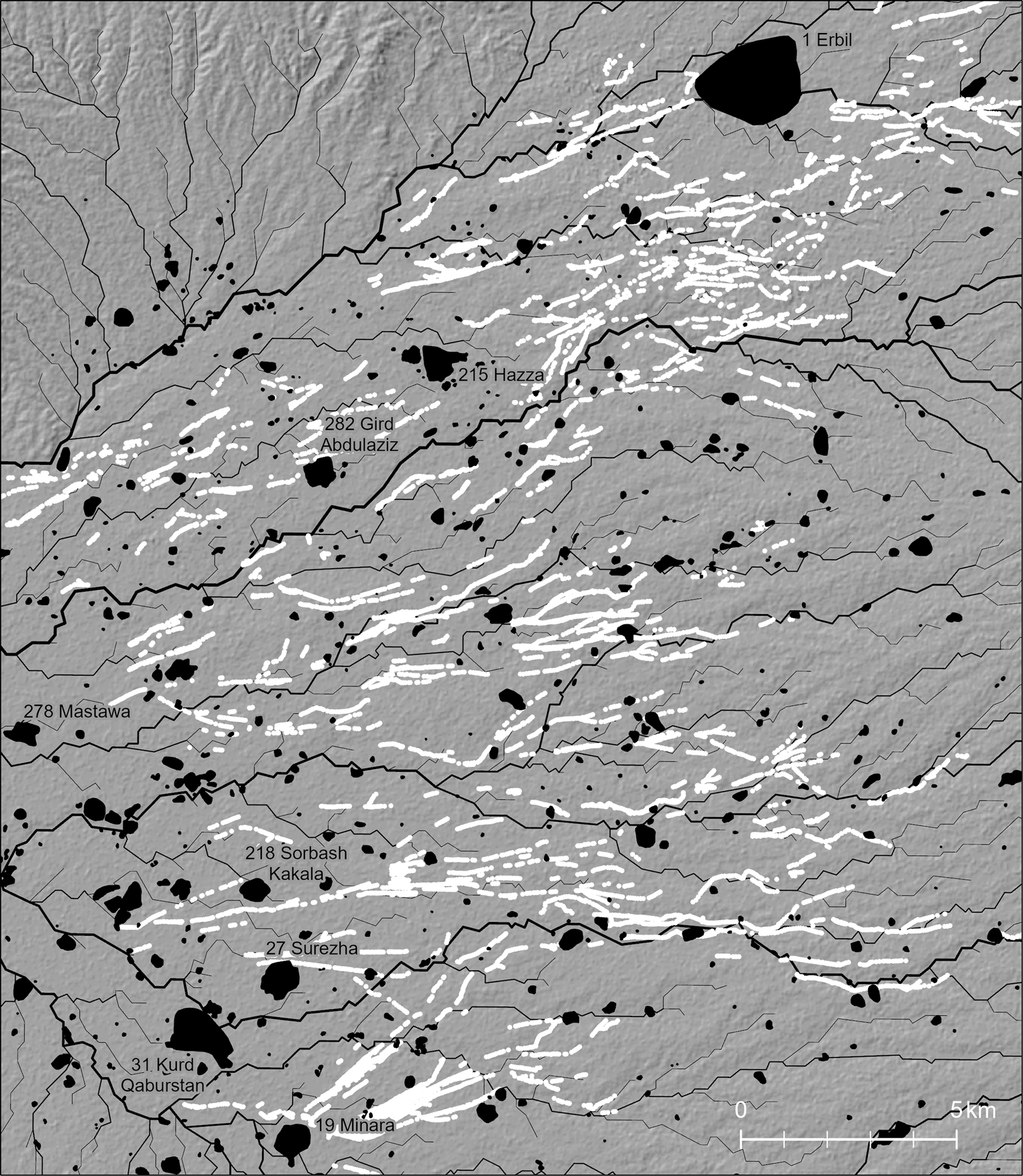
Fig. 23 Distribution of karez shafts and archaeological sites in the region south of Erbil.
Dating the physical remains of karez is difficult because they were in use for a long time and they often originated far from the settlements that they served. Textual sources inform us that karez were abundant on the Erbil plain at the end of the twelfth century a.d. and they were used intensively in the sixteenth century (İlhan Reference İlhan1994–1995). With a robust spatial database already in place, the project's next phase will investigate features’ associations with dated settlements, examine their morphology, and investigate possible textual sources that can shed light on the history of individual karez systems.
Tracks on the Erbil Plain
The plains of northern Mesopotamia preserve the incised traces of thousands of kilometers of ancient trackways. Most prominent are the tracks of the Syrian Jazira, mostly dated to the Early Bronze Age (Wilkinson and Tucker Reference Wilkinson and Tucker1995: 24–28; Ur Reference Ur2010b: 129–146). Recent remote-sensing based studies have shown that the trans-Tigridian region also preserves these features (Altaweel Reference Altaweel2008; Mühl Reference Mühl2013; Wilkinson et al. Reference Wilkinson, Wilkinson, Ur and Altaweel2005). These latter studies showed similar morphology and patterning but with less uniformity about dating.
The study of premodern tracks on the Erbil Plain has not been systematic to date, but already patterns are emerging that diverge strongly from the well-known patterns of the Syrian Jazira (Ur Reference Ur2003). Features do radiate outward from some tell sites, but the strikingly consistent radial patterns seen around nearly every EBA mound in the Jazira are absent. When radial systems can be recognized, they often have only a few tracks and appear more likely to be associated with MBA sites, rather than EBA (see, e.g., Site 214 near Kawr Gosk). None of the three largest EBA sites (Sites 17 Baqrta, 33, and 220) have unambiguous tracks associated with them, let alone the large radial systems seen around EBA cities in the Jazira.
The emerging patterning (Fig. 24) seems generally to be aligned on a single site, Erbil itself. Especially south of the city, the alignment of most features is north-south and rarely in obvious association with any particular site. For this reason, it seems most likely that the movement that produced these features was between the Lower Zab and the general region of Erbil.
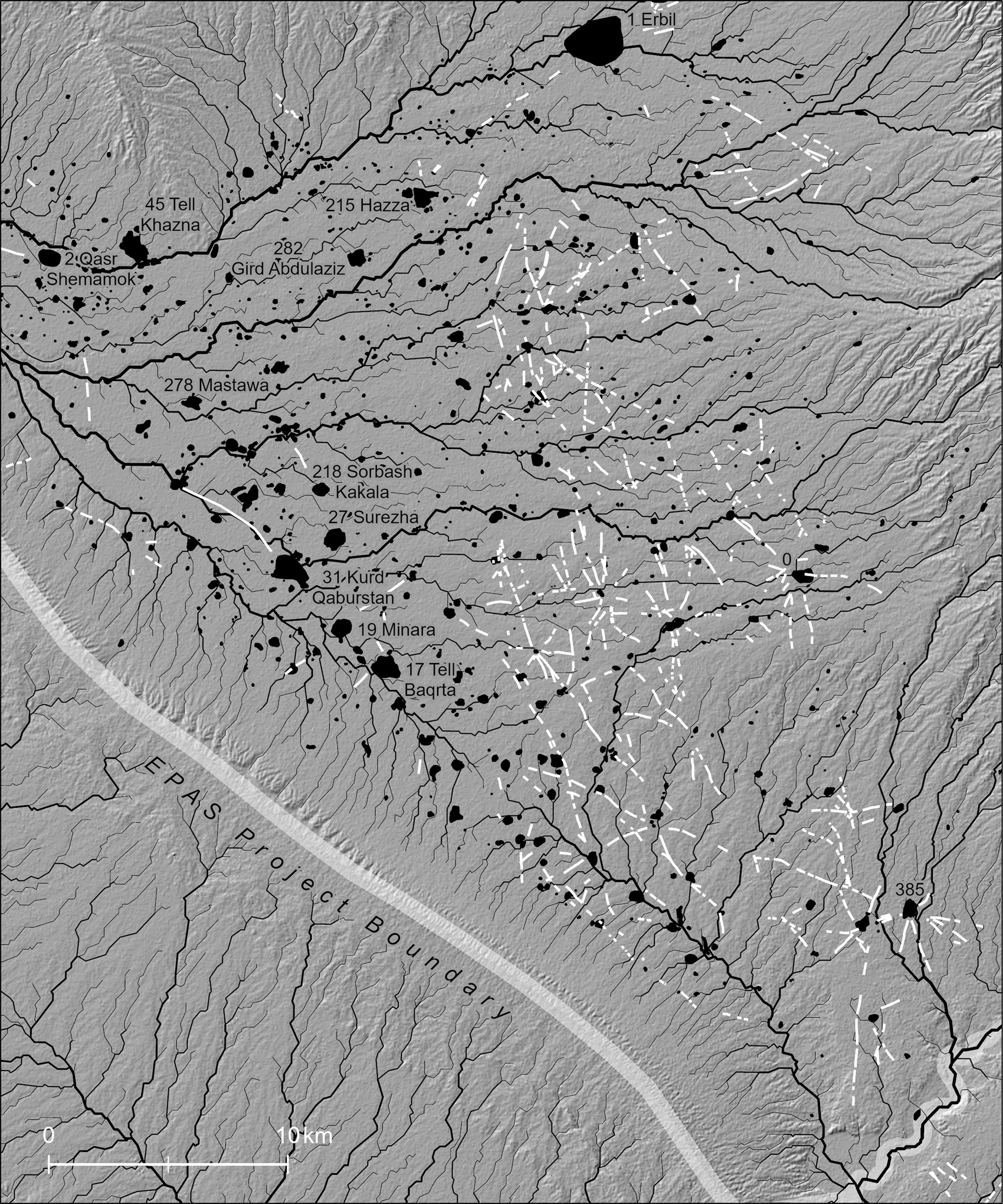
Fig. 24 Distribution of hollow way features between Erbil and the Lower Zab River.
It is unlikely, however, that the plain preserves a representative sample of trackway features. There are three major zones of track preservation: south of Erbil, immediately north-northwest of Erbil, and the region south of the Demir Dagh hills in Gwer nahiya. All three appear to be zones of taphonomic survival. For example, the southern zone is bounded at its west by the 350 m contour line; it appears that below that elevation, all features have been removed, probably by karez-fed irrigation systems. Similarly, the Gwer tracks are mostly to be found above 300 m ASL. In both cases, the preserved track features are far away from the largest sites, which are to be found lower on the plain and closer to the perennial Siwasor and Kurdara rivers. The most likely culprit for this landscape destruction is irrigation, perhaps already at the time of the Neo-Assyrian canal infrastructure but certainly by the time of the heavily irrigated 19th century landscape of karez.
When track features can be proposed for the lower part of the plain, they survive because they captured surface runoff and hence became part of the network of surface hydrology (Tsoar and Yekutieli Reference Tsoar and Yekutieli1993; Wilkinson et al. Reference Wilkinson, French, Ur and Semple2010: 763–767). For example, a deep and broad feature runs almost five km from Site 31 Kurd Qaburstan to Site 246 Aliawa. It now acts as a tributary drainage into the major wadi next to Aliawa. Both sites attained their largest extent in the MBA.
Threats to the Cultural Landscape
The Erbil Plain has escaped the extensive looting that ravaged the south of Iraq after 2003 or the pillaging of sites under Da'esh/ISIS during the Syrian civil war (Casana Reference Casana2015; Stone Reference Stone2008). It was never controlled by Da'esh and therefore was spared the ‘spectacles of destruction’ (Harmanşah Reference Harmanşah2015) its militants undertook in Ninua Governorate. Nonetheless, a range of threats to the cultural landscape of the plain exist.
The gravest threat is the ongoing growth of Erbil itself. Its booming economy in the years before 2014 fueled tremendous investment in development, especially building and road construction. The ancient lower town of Erbil disappeared under the modern city in the 1970s, and its growth in this decade is rapidly overtaking its agricultural hinterland. Since the EPAS project's initiation, the 120 m ring road was designed and is now almost entirely open for traffic. The next project is the 150 m ring road, five km beyond the 120 m road and a full ten km out from the Erbil citadel. Its future inevitability has been marked on the landscape by low earthen berms through the cereal fields of the countryside (Fig. 25).

Fig. 25 The planned 150 m ring road, south of Erbil. UAV oblique view, 15 October 2018 (photo by Khalil Barzinji).
Beyond Greater Erbil, the construction of rural housing also presents a threat. Concrete ‘weekend’ homes for wealthy families in Erbil are appearing on the ruins of nearly all villages destroyed in 1987, but also atop nearly any site that does not have an unambiguous Muslim cemetery. This process is, of course, how archaeological mounds formed in the first place, but these 21st century constructions involve mechanized leveling that can remove meters off the tops of mounds.
These new high rises, ring roads, and houses created a massive demand for cement, which in turn drove an expansion in gravel mining. The most accessible places for gravel extraction are the river valleys, which have now been systematically exploited. The industry has had a major impact on their scenic beauty but for the most part, archaeological sites are located outside of them. The major exception is the Bastora dam, discussed above, which was nearly removed by a nearby gravel mining operation. In some places, however, mining companies have begun to follow gravel beds under the adjacent river terraces that have been the locations of settlements for millennia. Gravel extraction requires the full removal of the sediments of the terraces and also any archaeological sites or features that might be on them. It is impossible to determine what has been lost if this destruction occurs before archaeological survey, so the real impact of this threat is unknown. It can, however, be shown that gravel mining along the Upper Zab river has had a tremendous impact on the terrace canals. Canal B has been completely removed in several places, including near its head at Kawr Gosk village. This threat is by no means unique to the Erbil region; in the wadis of the Navkur Plain, for example, gravel mining completely disarticulated a Neo-Assyrian quay, which is only known from ashlar blocks discovered in a gravel yard (Morandi Bonacossi Reference Morandi Bonacossi, Gaspa, Greco, Morandi Bonacossi, Ponchia and Rollinger2014: 448–449).
Conclusion and Prospects
In seven field seasons, the Erbil Plain Archaeological Survey has documented a broad settlement landscape in a region of great social and political importance, especially in the Bronze and Iron Ages. Preliminary results show some unexpected patterns: a high density of culturally Uruk settlements in the fourth millennium b.c.; variable urban morphologies in the Early Bronze Age; and the occurrence of low-density settlements at the end of the Sasanian period or the early Islamic period. The project's hypotheses about the planned nature of the Neo-Assyrian imperial core appear to have been confirmed, although the situation seems to have been more complex than in the provinces surrounding the core area, probably due to the longer history of continuous settlement.
Much more work remains to be done. The project has identified 728 sites to date, but over 800 potential sites remain to be visited. Most of the alluvial plain has been investigated, but the uplands to the north of Erbil are under-investigated, and the hills surrounding the plain have yet to be visited in any capacity. The project's chronological focus will shift next toward the two and a half millennia following the collapse of Assyria, with particular focus on the landscapes of karez irrigation.


