


THE SETTING AND CONTEXT OF THE VINČA-BELO BRDO TELL
The great tell or settlement mound of Vinča-Belo Brdo sits directly beside the Danube, a little to the south of Belgrade, Serbia (Figure 1). Its 8 m of Late Neolithic deposits span the later 6th to the mid-5th millennium cal BC, and are underlain by a Starčevo culture occupation of the earlier 6th millennium cal BC (Tasić et al. Reference Tasić, Marić, Penezić, Filipović, Borojević, Borić, Reimer, Russell, Bayliss, Barclay, Gaydarska and Whittle2015, Reference Tasić, Marić, Bronk Ramsey, Kromer, Barclay, Bayliss, Beavan, Gaydarska and Whittle2016). The site has given its name to the Vinča culture (or interaction sphere or network), which extends through the river valleys of the Danube, its tributaries and their catchments, in the northern and central Balkans, from southernmost Hungary and easternmost Croatia through southern Serbia and Kosovo down to northern Macedonia, and from Croatia and Bosnia-Herzegovina eastwards as far as parts of Transylvania in Romania (Figure 1). Belo Brdo, near the center of this distribution, appears to have emerged relatively early in the Vinča culture sequence and was clearly, as the largest known tell of the complex, a place of considerable and enduring significance. This was a time, after the initial emergence of a Neolithic way of life in the region, of the spread, consolidation, and diversification of settlement, involving the formation of big flat settlements and tells; the emergence of both larger communities and distinctive households within such sites; the intensification of subsistence; and changing materiality and the expansion of material networks (Chapman Reference Chapman1981, Reference Chapman2000; Kaiser and Voytek Reference Kaiser and Voytek1983; Tringham and Krstić Reference Tringham and Krstić1990; Tasić Reference Tasić2009; Tripković and Milić Reference Tripković and Milić2009; Orton Reference Orton2010). To understand the initiation, formation, duration, and ending of Vinča-Belo Brdo is to grasp some of the major features of the development of Neolithic communities in a major swathe of southeast Europe as a whole.
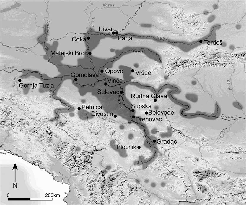
Figure 1 The location of Vinča-Belo Brdo and other important Vinča culture sites, and the approximate extent (shaded dark grey) of the occurrence of Vinča ceramics in southeast Europe.
DATING VINČA-BELO BRDO: INTERWOVEN STRANDS
Alison Wylie (Reference Wylie2002: 162–3) has suggested that “scientific arguments are more like cables than chains” and so individual lines of argument, insufficient on their own, when woven together can make a cumulatively persuasive case. The Belo Brdo tell has been the object of prolonged and intensive research, and as a result it is now possible to provide formally modeled radiocarbon chronologies for three aspects or strands of its chronology. This paper presents the third strand. Since each of the chronological models now available (and outlined below) for the tell is partial, addressing specific questions that can be tackled using the particular part of the site archive on which that model is based, we go on to compare the advantages and weaknesses of the individual strands, and to assert the strength of the combined, interwoven cable. That enables a more robust consideration of the overall chronology of the site. This is important not only in its own right, given the significance of this individual tell, but also for the wider understanding of the development of Neolithic tells across southeast Europe as a whole. While many have been excavated (Whittle Reference Whittle1996; Rosenstock Reference Rosenstock2009; Anthony and Chi Reference Anthony and Chi2010), only four others are currently the subject of chronological modeling (though at varying resolutions): Uivar, western Romania (Schier et al., Reference Draşovean, Schier, Bayliss, Gaydarska and Whittleforthcoming), Polgár-Csőszhalom in northern Hungary (Raczky et al. Reference Raczky, Anders, Sebők, Csippán and Tóth2015), Pietrele in southern Romania (Reingruber Reference Reingruber2015), and Okolište in Bosnia (Hofmann Reference Hofmann2013). Further afield, formal chronological modeling of the even larger tells at Çatalhöyük, Anatolia, and Tell Sabi Abyad, Syria, must also be noted (van der Plicht et al. Reference van der Plicht, Akkermans, Nieuwenhuyse, Kaneda and Russell2011; Bayliss et al. Reference Bayliss, Farid and Higham2014, Reference Bayliss, Brock, Farid, Hodder, Southon and Taylor2015; Plug et al. Reference Plug, van der Plicht and Akkermans2014; Marciniak et al. Reference Marciniak, Barański, Bayliss, Czerniak, Goslar, Southon and Taylor2015). Getting the approach right for sites of considerable depth and size, with potentially complex stratigraphies and formation processes, in order to set the standards for future research, is fundamental.
Research on the Vinča-Belo Brdo tell began with excavations by Miloje Vasić (Reference Vasić1932, Reference Vasić1936a, Reference Vasić1936b, Reference Vasić1936c) at intervals from 1908–1934, which among other things achieved a deep section right through the deposits (Figure 2). That was followed by further fieldwork by Nikola Tasić and Jovan Todorović (from 1978–1983), and then Dragoslav Srejović (from 1983–1986), which revealed an extensive area of the upper deposits and created a new profile right through the tell. At intervals from 1998–2009, Nenad Tasić excavated the uppermost meter of the Late Neolithic deposits in Sector II over an area of some 35 by 40 m, and revealed three, possibly four, late Vinča culture structural horizons (Tasić Reference Tasić2005; Tasić and Ignjatović Reference Tasić and Ignjatović2008). From early in the investigations by Vasić, Belo Brdo served as a culture-history and chronological yardstick for the Vinča culture and beyond (Childe Reference Childe1929). An extensive series of celebrated attempts have been made, using the stratified sequence, to order the development of the material, principally the pottery, largely by typology but more recently by correspondence analysis (summarized, with references, in Schier Reference Schier1996, Reference Schier2000). Latterly, a modest number of 14C dates were obtained on bone and antler artifacts excavated by Vasić, which have been incorporated in Bayesian chronological models for Belo Brdo and the Vinča culture (Schier Reference Schier1996, Reference Schier2000; Borić Reference Borić2009, Reference Borić2015). Recently, as part of a major project, The Times of Their Lives (ToTL), which is applying Bayesian modeling to a series of case studies across the European Neolithic (see Acknowledgments), many more 14C dates have been obtained that have been interpreted within a series of formal, Bayesian chronological models that investigate different aspects of the tell. The first strand of this interwoven work at Vinča-Belo Brdo considered the open-area excavations of the latest Neolithic deposits, combining 34 14C measurements with the results of modern open-area excavation (Tasić et al. Reference Tasić, Marić, Penezić, Filipović, Borojević, Borić, Reimer, Russell, Bayliss, Barclay, Gaydarska and Whittle2015). The second focused on the sequence through the tell revealed by the extensive Vasić excavations (Tasić et al. Reference Tasić, Marić, Penezić, Filipović, Borojević, Borić, Reimer, Russell, Bayliss, Barclay, Gaydarska and Whittle2016). This chronology is based on an age-depth model of 85 measurements on 82 samples, mostly bone and antler artifacts, which are only recorded by depth of recovery. Only 14 samples have been identified as intrusive or residual in this modeling, an outcome which strongly supports Schier’s (Reference Schier2000: 192) conclusions, based on correspondence analysis of the pottery, that Vasić’s 10-cm spits generally show a coherent chronological resolution, and that the contamination effects caused by unrecognized pits and reworked material are not serious enough to discredit the entire sequence and the analysis of cultural finds based upon it.

Figure 2 The section face through the tell at the time of the Vasić excavations.
In 2004–2005 and again in 2012–2014 (as part of a longer campaign of fieldwork from 1998–2015), it was necessary because of the slippage and cracking of part of the old section face left by Vasić (Figure 2), to undertake further limited excavation, leading to a complete, new profile through the tell in Sector I, using single-context recording (see also Figure 10). Since this part of the site was believed to contain all the strata previously established by Vasić (up to 1934) and Nikola Tasić (in 1982), it was seen as a valuable source of samples for the third strand in the collaboration with the ToTL project, giving the opportunity further to refine the chronology of Vinča-Belo Brdo. Another section through the tell (Profile 1/2011) was cleaned in 2011, approximately 20 m to the northwest of the new deep sounding, as a part of a survey of the nature and extent of the land-slipping that appeared on the site some years ago. In this profile, ~6.2 m of Neolithic deposits were revealed.
AIMS OF THE DATING PROGRAM FOR THE NEW DEEP SOUNDING
The following aims were defined to guide our sampling strategy and modeling of the chronology of the new deep sounding. We hoped to
-
∙ determine whether there was really a gap between the Starčevo and Vinča occupations on the site as suggested by our previous work on the Vasić archive;
-
∙ construct a detailed structural narrative through the whole depth of the tell, dating the occupation and destruction of houses and related features, and episodes of burning;
-
∙ relate and compare this detailed structural narrative to the existing account of the upper horizons in Sector II and the overall framework provided by the Vasić sequence, and in particular, further to explore the processes by which the tell was established, maintained, expanded, and eventually abandoned; and
-
∙ assess critically the potential insights into the context and wider history of this tell—and by implication others—which such detailed analysis enabled by modern excavation methodologies could bring.
Given the current stage of ongoing post-excavation analysis and the small area opened (33 m2, reducing to 15 m2 at about 4.5 m depth for health and safety reasons), this paper will say comparatively little about potential revision to our understanding of material sequences at Vinča-Belo Brdo. In the future, however, the refined chronology presented here promises to be important, especially for the upper, or Vinča D, levels, which could not through force of circumstance (from 1998 onwards) be the subject of the correspondence analysis carried out on material below a depth of 4 m from the Vasić archive (Schier Reference Schier1996).
The Bayesian Approach at Vinča-Belo Brdo
The new 14C dating program for Vinča-Belo Brdo was conceived within the framework of Bayesian chronological modeling (Buck et al. Reference Buck, Cavanagh and Litton1996). This allows the combination of calibrated 14C dates with archaeological prior information using a formal statistical methodology. Since this approach integrates more than one type of information, it provides date estimates that are not only formal but also more robust and precise than those reliant on only one element of the chronological information available about a site (such as either the stratigraphy or the scientific dating). Bayesian chronologies are, however, not absolute but fundamentally interpretative. This means that it is essential to explore and compare alternative models to investigate the reliability of our suggested chronologies.
The deep sequence of Neolithic deposits at Vinča-Belo Brdo is particularly suited to this approach, since the relative dating inferred from the site sequence can provide extremely informative prior information to constrain the chronological models. Using this relative dating information provided by the sequence of deposits through the tell, we have constructed three independent models for different parts of the site.
The chronological model for the three uppermost certain structural horizons excavated in Sector II is presented in Tasić et al. (Reference Tasić, Marić, Penezić, Filipović, Borojević, Borić, Reimer, Russell, Bayliss, Barclay, Gaydarska and Whittle2015: Figure 8). This model is based on the stratigraphic sequence recovered by recent excavations (1981–1986 and 1998–2009) and concentrates on estimating the duration of these horizons and the date when the Vinča culture deposits at Belo Brdo ended.
A model is presented in Tasić et al. (Reference Tasić, Marić, Bronk Ramsey, Kromer, Barclay, Bayliss, Beavan, Gaydarska and Whittle2016: Figure 17) for the whole sequence of Neolithic deposits excavated by Miloje Vasić (1908–1934). This uses a Poisson process age-depth model, with the rigidity of the process defined as the 10-cm spits used by Vasić to excavate the tell (Bronk Ramsey Reference Bronk Ramsey2008; Bronk Ramsey and Lee Reference Bronk Ramsey and Lee2013). This model concentrates on dating the large assemblage of material culture recovered in stratigraphic sequence by Vasić, which has been the subject of so much subsequent research (Borić Reference Borić2009; Tasić et al. Reference Tasić, Marić, Bronk Ramsey, Kromer, Barclay, Bayliss, Beavan, Gaydarska and Whittle2016).
Here, we combine the detailed stratigraphic record for the entire depth of Neolithic deposits, excavated using single contexts and a Harris matrix in 2004–2005 and 2012–2014, with a series of 14C dates obtained on single-entity, short-lived samples whose taphonomy can be interpreted from the detailed contextual evidence available. This model concentrates on understanding the structural sequence of Neolithic deposits and features.
Radiocarbon Dating
A total of 101 14C measurements have been obtained from the 2004–2014 deep sounding, and two further measurements from the base of Profile 1/2011 (Table 1). All are conventional 14C ages, corrected for fractionation (Stuiver and Polach Reference Stuiver and Polach1977). The samples dated by the Scottish Universities Environmental Research Centre (SUERC) were pretreated, combusted, and dated by accelerator mass spectrometry (AMS) as described by Dunbar et al. (Reference Dunbar, Cook, Naysmith, Tripney and Xu2016). The animal bone samples were processed by gelatinization and ultrafiltration. The samples dated by the 14CHRONO Centre, The Queen’s University, Belfast, were processed and dated by AMS using methods described by Reimer et al. (Reference Reimer, Hoper, MacDonald, Reimer and Thompson2015). Most charred materials were pretreated using an acid wash onlyFootnote 1 and most samples were graphitized using hydrogen reduction (Vogel et al. Reference Vogel, Southon, Nelson and Brown1984).Footnote 2
Table 1 Radiocarbon ages and stable isotopes measurements from the 2004–5 and 2012–14 deep sounding and profile P1/2011 from Vinča-Belo Brdo; the statistical consistency of replicate measurements has been assessed using the method of Ward and Wilson (Reference Ward and Wilson1978); quoted δ13C values have been measured by IRMS (insufficient carbon remained for this analysis for UBA-22450, UBA-22587, and UBA-22635).

Seven pairs of replicate 14C measurements are available, all of which are statistically consistent (Table 1; Ward and Wilson Reference Ward and Wilson1978). Replicate δ13C values were also obtained on these samples, five of which are statistically consistent. The other two pairs are widely divergent, although all quoted values are within the observed range for charred plant remains from the site (SUERC-54846 and UBA-22583, T′=7.2; and SUERC-54853 and UBA-22588, T′=65.2, T′(5%)=3.8; ν=1 for both). The single replicate pair of δ15N values are statistically consistent.
Chronological Modeling
The chronological modeling described in this section has been undertaken using OxCal v 4.2 (Bronk Ramsey Reference Bronk Ramsey1995, Reference Bronk Ramsey2009a, Reference Bronk Ramsey2009b), and IntCal13 (Reimer et al. Reference Reimer, Bard, Bayliss, Beck, Blackwell, Bronk Ramsey, Buck, Cheng, Edwards, Friedrich, Grootes, Guilderson, Haflidason, Hajdas, Hatté, Heaton, Hoffmann, Hogg, Hughen, Kaiser, Kromer, Manning, Niu, Reimer, Richards, Scott, Southon, Staff, Turney and van der Plicht2013). The models are defined by the OxCal CQL2 keywords and by the brackets on the left-hand side of Figures 3–8. In the diagrams, calibrated 14C dates are shown in outline and the posterior density estimates produced by the chronological modeling are shown in solid black. The highest posterior density (HPD) intervals, which describe the posterior distributions, are given in italics.

Figure 3 Overall structure of the chronological model for the new deep sounding at Vinča-Belo Brdo. The component sections of this model are shown in detail in Figures 4–8. Each distribution represents the relative probability that an event occurred at a particular time. For each of the dates two distributions have been plotted: one in outline which is the result produced by the scientific evidence alone, and a solid one which is based on the chronological model used. The other distributions correspond to aspects of the model. For example, the distribution start Belo Brdo deep sounding is the estimated date for when the accumulation of Vinča pottery began to accumulate in this trench. Dates followed by a question mark have been calibrated (Stuiver and Reimer Reference Stuiver and Reimer1993), but not included in the chronological model for reasons explained in the text. The large square brackets down the left-hand side of Figures 3–8 along with the OxCal keywords define the overall model exactly.

Figure 4 Probability distributions of dates from the spine (lower). UBA-22640 (intrusive in H 01-14) is not shown as it dates to the late 5th millennium cal BC. The format is identical to Figure 3. The large square brackets down the left-hand side of Figures 3–8 along with the OxCal keywords define the overall model exactly.

Figure 5 Probability distributions of dates from the spine (upper). UBA-26548 (intrusive in H 01-12) is not shown as it dates to the 1st millennium cal BC. The format is identical to Figure 3. The large square brackets down the left-hand side of Figures 3–8 along with the OxCal keywords define the overall model exactly.


This study is based on using the relative dating provided by the matrix of archaeological deposits to refine the calibration of a series of 14C dates on samples from those layers. For this to be valid, however, the relative order in which the samples ceased to exchange carbon with the biosphere must be the same as the relative order of dirt in the ground. Samples must thus be not only short-lived single-entities from a well-understood carbon reservoir (Ashmore Reference Ashmore1999), but they must also have been freshly deposited in the context from which they were recovered. The association between the dated event and the target event (Dean Reference Dean1978) is thus paramount.
This relationship is never known but can be assessed with varying degrees of reliability. It is most secure when articulated groups of bones are recovered (since this means that tendons or other soft flesh must have been present at the time of deposition and so the animal was recently dead when buried). The entire faunal assemblage from the new deep sounding was scanned for articulating groups of bones, or for juvenile bones with refitting unfused epiphyses, but none was found. This may partially be the result of the comparatively small assemblage recovered from the small area excavated, but also probably relates to practices of refuse disposal by the Neolithic inhabitants of Belo Brdo.
Only in one case was there physical evidence of the fresh deposition of a sample. This was the calcined rib from a human individual who probably died in the fire that destroyed H01/12 (UBA-22450; Table 1).
Failing physical evidence, our sampling strategies focused on material that could be interpreted as having a functional relationship with the deposit from which it was recovered. This inference can be made with varying degrees of security. The material submitted fell into the following categories:
-
1. Samples functionally related to the use of particular features, such as charred plant remains recovered from ash fills in ovens (n=43).
-
2. Samples associated with destruction, such as charred plant remains from wall debris that were probably in a house when it was demolished/destroyed (n=17).
-
3. Samples associated with construction, such as charred plant remains found within the matrix of clay floors (n=3).
-
4. Samples associated with occupation, such as disarticulated bones found on the floors of houses (n=23).
-
5. Refuse, such as charred plant remains or disarticulated bones found in pit fills (n=14).
A Harris matrix of the structures and features from which 14C dates have been obtained through the deep sounding is shown in Figure 9, and a composite section through the sounding is shown in Figure 10. (That composite of the 2012–2014 section reflects the practical necessity to reduce the size of the sounding from a depth of about 2 m, for reasons of time, cost, and safety.) The model described below is defined by the OxCal CQL2 keywords and brackets on the left-hand side of Figures 3–8. HPD intervals for the estimated dates of construction and disuse of buildings and ovens and the infilling of dated pits derived from this model are given in Table 2, and those for the duration of use of the structures are given in Table 3.
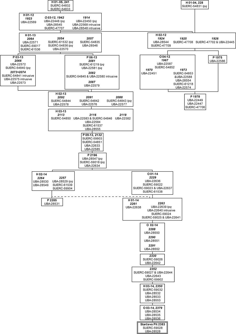
Figure 9 Harris matrix of structures and features from the 2004–2005 and 2012–2014 deep sounding through Vinča-Belo Brdo from which 14C dates have been obtained.

Figure 10 Composite section of the 2004–2005 and 2012–2014 deep sounding through Vinča-Belo Brdo, indicating the positions of deposits incorporated in the spine of the chronological model (Figures 4 and 5). Profile 1 photographed May 2013; Profiles 2 and 3 photographed August 2014. For further detail, see text.
Table 2 Highest posterior density (HPD) intervals for the construction and demolition or destruction of buildings and ovens, and the infilling of dated pits (derived from the model defined in Figures 3–8, and see Figure 13).

Table 3 Highest posterior density (HPD) intervals for the duration and use of buildings and ovens (derived from the model defined in Figures 3–8, and see Figure 14).

At the base of the tell, pit P 2383, more than 1.4 m in diameter and 0.62 m deep, was cut though the old land surface. This contained sherds in the Starčevo tradition. The two 14C results from this pit are divergent (T′=14.8; T′(5%)=3.8; ν=1; Ward and Wilson Reference Ward and Wilson1978), and so the pit is best dated by the later fragment of charcoal to 5715–5615 cal BC (SUERC-59028; Table 1; Stuiver and Reimer Reference Stuiver and Reimer1993).
On top of the old land surface, three statistically consistent 14C measurements (T′=1.7; T′(5%)=6.0; ν=2), have been obtained on wheat from oven 03/14, which probably represents the start of Vinča occupation in this area.
Stratigraphically later than this oven, the northeast corner of burnt house 03/14 was excavated. Four statistically consistent results (T′=1.3; T′(5%)=7.8; ν=3) have been obtained from within the collapsed matrix of the eastern wall. The taphonomy of this material is unclear, but their statistical consistency suggests that the dated material probably relates to the use of the structure.
Overlying this, a thin patch of red burnt clay, 2352, probably represents the truncated remains of a fired feature, such as an oven or hearth, but it is possible that an underlying post-hole (2354) is related and that this feature actually represents the remnant of a burnt house. Four measurements on three fragments of charred plant remains are statistically consistent (T′=2.7; T′(5%)=6.0; ν=2), suggesting again that the dated material probably relates to the use of the structure.
Another patch of burnt orange clay, 2330, probably representing another remnant hearth, lay above, producing two statistically consistent measurements (T′=0.8; T′(5%)=3.8; ν=1) on material that probably related to the use of the feature. Stratigraphically later than this was oven 02/14. A sequence of samples was dated from this feature, and in all cases the dates have good individual agreement with the sequence (Figure 4).
Further east, the collapsed western wall of house 01/14 is again stratigraphically later. The structure itself lay beyond the limit of excavation. Six 14C results have been obtained on five samples of short-lived charred plant remains, from within the collapsed rubble of the wall. The taphonomy of this material is not well understood, but probably relates to materials that were in the house when it burnt down. One result (UBA-22640) is clearly intrusive (falling down a prominent crack on its southwest side) and has been excluded from the model. The grain of wheat dated by UBA-22639 has poor agreement (A: 17) with its position in the model and appears to be residual. House 01/14 was destroyed by fire.
Above house 01/14 lay oven 01/14. Five statistically inconsistent measurements (T′=8.9; T′(5%)=7.8; ν=3) have been obtained on four fragments of short-lived carbonized plant material from the floor of this oven. The charred lentil (UBA-22635) from a white and grey ash layer around the oven was thought to be associated with its use but is clearly intrusive, and has been excluded from the model.
Above this, three statistically inconsistent measurements (T′=24.3; T′(5%)=6.0; ν=2) are available on samples from pit 2196. Two of these (SUERC-59018 on a red deer radius, and UBA-28547 on a grain of wheat) appear to be residual, and have been modeled as such.
Stratigraphically later than this was firepit 09/13, which produced four statistically consistent measurements (T′=5.9; T′(5%)=7.8; ν=3) on single fragments of short-life charcoal that apparently relate to its final use.
The unburnt house 03/13 was constructed immediately after the final firing of firepit 09/13. This building contained an oven, 01/13. A single fragment of hazel charcoal has been dated (UBA-22582), from what was probably a layer (2219) associated with its use. Five statistically consistent measurements on four fragments of charred plant material (T′=5.2; T′(5%)=7.8; ν=3) have been obtained from the demolition of the oven. Finally, a disarticulated sheep/goat mandible has been dated (SUERC-54850) from within the unburnt demolition rubble of the house. The association between this bone and the deposit in which was found is uncertain. In the model, we have interpreted this sample as relating to the use of the structure, and the date has good individual agreement with this suggestion (A: 66). But it is possible that soil was brought in to level the remains of the house, in which case it could be reworked from earlier deposits.
Overlying house 03/13 was another unburnt house, 02/13. Six 14C dates are available on samples from it. Two statistically consistent measurements (T′=2.0; T′(5%)=3.8; ν=1) are available from a patch of burning on the floor (2092) and probably relate to its use. A disarticulated cattle astragalus found on the floor beneath the demolition rubble (SUERC-54842) was similarly related to its use. The taphonomy of a fragment of hazel charcoal (UBA-22576) from the same deposit is more problematic, as this might relate to the use of the house but could also have formed part of the clay matrix of the floor itself. The former interpretation is incorporated in the model, in which this measurement has good individual agreement (A: 67). The taphonomy of two further samples from the unburnt demolition rubble of the building is again unclear. SUERC-54843, on a fragment of short-lived charcoal, appears to be residual and has been incorporated in the model as a terminus post quem, although the charred endocarp from the same deposits appears to relate to the use of the structure (UBA-22577).
Stratigraphically later than house 02/13, a shallow, oval pit, 06/13, containing a succession of largely ashy fills, was found. Five 14C measurements are available on four fragments of charred plant remains from different contexts in this feature. The samples from the upper fills are problematic, as the charred endocarp dated by SUERC-54845 and UBA-22580 appears to be intrusive and has been excluded from the model and the samples from the overlaying fill (2081) appear to be residual.
Above this pit, eight samples have been dated from another unburnt house, 01/13. Three samples of charred plant material from unit 2064 are of uncertain taphonomy. This appears to have consisted of the timber and clay foundation of the clay floor of the building. These remains might therefore relate to the makeup of the floor rather than its use. Three samples have also been dated from unit 2054, a spread of cultural material that seems to have been left on the floor of the building before its demolition. Finally, two samples were dated from 2057, the unburnt demolition debris of the building, which again—tentatively—may relate to its use. A model that incorporates all this material as part of the use of the building has poor overall agreement (Amodel: 48). It appears that SUERC-61532 and SUERC-54836 are residual.
On top of house 01/13 was the burnt house 01/12. Three statistically consistent (T′=3.6; T′(5%)=6.0; ν=2) 14C measurements are available for oven 03/12. A further measurement, statistically consistent (T′=4.8; T′(5%)=7.8; ν=3) with those from the oven, was found on the floor of this burnt structure. This material probably relates to a store of pulses in the roof space, destroyed in the fire, or which formed part of a thatched roof. Within the burnt destruction rubble, two more charred pulses and a fragment of calcined human bone have been dated. The charred pulses from the destruction rubble are clearly intrusive (UBA-22568 and -28548) and have been excluded from the model. UBA-22450 on the calcined human rib is anomalously old for its position in the model (A: 13) and may have incorporated a component of carbon from old wood during the fire (Olsen et al. Reference Olsen, Heinemeier, Hornstrup, Bennike and Thrane2013; Snoeck et al. Reference Snoeck, Brock and Schulting2014). It has therefore been modeled as a terminus post quem for this building. One of the fragments of charcoal dated from the oven (UBA-22448) also seems to be residual.
Above house 01/12 was house 01/05. No sampling for charred plant remains could be undertaken in the excavations in 2004–2005 so datable material was scarce from this building. Two animal bones that were recovered on the floor of the building have been dated, however, producing statistically consistent measurements (T′=0.0; T′(5%)=3.8; ν=1). These appear to have been left on the floor of the building when it was burnt down.
The sequence of buildings and structures just described forms a single stratigraphic string through the whole depth of the deposits excavated in the new deep sounding (Figures 4–5 and 9–10). Additional features and buildings, however, were excavated that can be related to elements of that string. The first subsidiary strand is formed by pit 2285, which was earlier than house 02/14, which was earlier than pit 2196 (Figure 6), which is part of the spine of deposits already described. Excavation could not continue below pit 2285, for health and safety reasons. House 02/14, however, is almost certainly stratigraphically later than house 01/14 because the latter was sealed by a layer, 2271, which from the section seems to have extended beneath house 02/14 (although the relationship was not confirmed by excavation). A single charred lentil has been dated from the fill of pit 2285, and the date has good individual agreement with its place in the sequence (Figure 6). Above pit 2285, five statistically consistent measurements (T′=8.3; T′(5%)=9.5; ν=4) have been made on samples of charred plant remains from within the burnt demolition rubble of house 02/14. One of them, however, UBA-28529, appears to be residual.
The second subsidiary string is formed by pit 03/13 (Figure 7). This is interstratified between the demolition of house 02/13 and the construction of house 01/13. Five statistically inconsistent measurements (T′=18.2; T′(5%)=9.5; ν=4) are available from deposits that are related to this feature. Three measurements come from units 2074 and 2073, which are parts of the layer into which the pit was cut, which were scorched by the deposition of hot ash or in situ burning that occurred in the pit. Both charred plant samples from 2074, the top surface of the layer, are intrusive (SUERC-54841 and UBA-22575), probably due to the extensive cracking in this area. One of the charred grains from the fill of the pit (SUERC-54840) is residual.
The last subsidiary string (Figure 8) begins a pit with fill 1978. This was overlain by oven 04/12 and pit 1975, which in turn underlay house 02/12. This house in turn is stratigraphically earlier than houses 01/04 and 01/12, which appear in the main spine of the model (Figure 9). Three statistically consistent measurements (T′=1.4; T′(5%)=6.0; ν=2) are available on charred plant material from the fill 1978, relating to the use of the pit. One measurement on a single charred grain of barley is available from pit 1975. Eight statistically consistent measurements (T′=8.3; T′(5%)=12.6; ν=6) from seven samples on short-lived charred plant material and charcoal are available from oven 04/12, which is close to and at the same level as pit 1975. Five statistically consistent measurements (T′=4.5; T′(5%)=7.7; ν=3) come from four samples of charred plant material and charcoal from 1973, a layer of soil to the immediate west of the oven 04/12, interpreted as rake-out and containing material from the use of the oven. A single measurement on short-lived charcoal is available from 1970, a white ash layer with charcoal to the immediate southeast of the oven. Two measurements are available on charred grain and short-lived charcoal from 1967, the topmost floor of the oven, interpreted as relating to its final use. House 02/12 lay directly above these two features. Five statistically consistent measurements (T′=1.7; T′(5%)=7.7; ν=3) on four samples of a charred wheat grain and disarticulated animal bones are available from the floor of this structure. The evidence for burning is ambiguous.
Directly above house 02/12 lay house 01/04. One measurement on a disarticulated animal bone is available from an ash concentration on its floor. This is clearly residual and has been treated as a terminus post quem in the model.
Overall, this model suggests that Vinča occupation in this trench began in 5205–5095 cal BC (95% probability; start Belo Brdo deep sounding; Figure 3), probably in 5170–5110 cal BC (68% probability). The end of the dated sequence in this trench came in 4635–4565 cal BC (95% probability; end Belo Brdo deep sounding; Figure 3), probably in 4625–4590 cal BC (68% probability). No material associated with the use of the latest houses, H 01/04 and H 01/05, could be dated, however, and Vinča occupation certainly continued later in this trench.
Overall, of the 101 measurements obtained from the 2004–2005 and 2012–2014 deep sounding, eight are excluded from this modeling as they are on samples that are considered to be intrusive in the context from which they were recovered. Given the extensive cracking that crossed the excavated area (Figure 11), the presence of such material is unsurprising. A further 13 measurements have been included in the model as termini post quos (using the AFTER function of OxCal). One of these, the calcined bone of the person thought to have died in the fire that destroyed house 01/12 (UBA-22450), may incorporate a fuel-offset from the substantial structural timbers of that building (see above), but the other 12 are thought to be residual based on the compatibility of these dates with others with which they can be related by stratigraphy. Three-quarters of these residual samples come from material that was thought to be associated with occupation or refuse disposal, which together make up less than a third of the samples submitted.

Figure 11 Photograph showing cracking around H03/13
DISCUSSION
We are now in a position to weave together the strands of evidence from all three chronological models for Vinča-Belo Brdo. This enables a more detailed biographical approach to the birth, growth, and decline of the tell than previously possible.
The Conditions for a Beginning: The Gap between the Starčevo and Vinča Occupations
The date estimates for Starčevo occupation and the start of the Vinča occupation from the different components of our work at Belo Brdo are shown in Figure 12. The Starčevo pit P 2383 found in the base of the new deep sounding provided a date in the 57th century cal BC, which is entirely compatible with the start of Pit Z from the Vasić excavations.

Figure 12 Probability distributions for dates and key parameters for Starčevo occupation and the beginning of Vinča occupation at Belo Brdo in different areas of the tell. Posterior density estimates are taken from the model defined in Figures 3–8 (SUERC-59028 and start Belo Brdo deep sounding) and the model illustrated in Tasić et al. (Reference Tasić, Marić, Bronk Ramsey, Kromer, Barclay, Bayliss, Beavan, Gaydarska and Whittle2016: Figure 17; start Starčevo burials, end Starčevo burials, and 9.3m). The 14C measurements from Profile 1/2011 have been calibrated (Stuiver and Reimer Reference Stuiver and Reimer1993).
We have no evidence for later Starčevo occupation in the area of the new deep sounding, although Pit Z (dated in the Vasić strand) continued in use for burial until probably the mid-55th century cal BC. There is a clear gap, however, between the end of Starčevo activity at Belo Brdo and the beginning of Vinča occupation, of 45–220 yr (95% probability; gap; Tasić et al. Reference Tasić, Marić, Bronk Ramsey, Kromer, Barclay, Bayliss, Beavan, Gaydarska and Whittle2016: Figure 18), probably 120–200 yr (68% probability).
That results from two separate locations are in agreement gives us confidence that there is indeed a significant interval between the Starčevo and Vinča occupations across this portion of the site at least, though we note the great size of the tell and cannot exclude the possibility of a different relationship elsewhere. It has been suggested that it was not by chance that the Vinča occupation was initiated above an older site (Chapman Reference Chapman2000: 203–4). Either the older site could still physically be recognized, or the social memory of it survived over a span of more than a century.
Whether such a gap applies more widely in the transition between the Starčevo and Vinča cultures opens an important but much wider question, to which we cannot do justice here. The default expectation, in a chest-of-drawers relative chronology, is that one should follow the other without a significant break, or even overlap, and the argument is then over the potential processes involved. But it will be for future research formally to model the relationship between late Starčevo and early Vinča culture over a wider geographical area. It may be worth noting the opinion of some Vinča culture specialists that there are considerable differences between the two phenomena, and it has often been assumed in the culture-historical framework that the Vinča culture was the product of fresh population from the south (e.g. Lazarovici Reference Lazarovici1979: 221; cf. Hervella et al. Reference Hervella, Rotea, Izagirre, Constaninescu, Alonso, Ioana, Lazăr, Ridiche, Soficaru, Netea and De-La-Rua2015).
Foundation
The Vinča culture sequence in the new deep sounding starts in the 52nd century cal BC. By comparison, the start of the tell as estimated from our first strand, the Vasić sequence, clearly falls in the 53rd century cal BC (Tasić et al. Reference Tasić, Marić, Bronk Ramsey, Kromer, Barclay, Bayliss, Beavan, Gaydarska and Whittle2016: Figure 17). It is very unusual, if not unprecedented, to have chronological estimates for the initiation of different parts of a tell of the Vinča culture or elsewhere in the southeast European Neolithic, and this presumably informs us about an initially slow growth and gradual horizontal expansion of the settlement mound. This information is precious, since we know so little about the conditions of foundation and initial growth, when a site is transformed from nascent buildup to visible mound (Chapman Reference Chapman1997).
Continued Growth
The sequence from the new deep sounding suggests a regular, steady buildup in that part of the tell, with a succession of burnt and unburnt houses, ovens, and pits. No stratigraphic hiatus was observed in the field, nor is any suggested by the formal modeling. This picture of constant, unrelenting growth is also suggested by the age-depth modeling of the Vasić sequence, and by seriation of the pottery, up to 4 m depth (Schier Reference Schier1996). Because of slippage at the top of the new deep sounding, we are reluctant to estimate a rate of accumulation for this part of the tell, though the figure of approximately 1 m per century extrapolated from the Vasić section may be broadly comparable. This is significant because it has been claimed that in its later stages Vinča-Belo Brdo declined in importance relative to other sites and regions, in the ritual sphere (Chapman Reference Chapman2000: 216–8). Nonetheless, the indications are that its physical growth continued uninterrupted.
House Lives on the Growing Tell
The model from the 2004–2005 and 2012–2014 deep sounding provides for the first time a detailed structural narrative for houses through most of the sequence at Vinča-Belo Brdo (Figures 13–14). We now have estimated the date of construction and use for nine (or possibly 10) structures from this trench to add to the dating of House 8 in Sector II, the structure there whose duration can be estimated (Tasić et al. Reference Tasić, Marić, Penezić, Filipović, Borojević, Borić, Reimer, Russell, Bayliss, Barclay, Gaydarska and Whittle2015: Figure 8). This allows us to consider questions about the tempo of house building, use, and replacement, in a way that is not possible from the surviving archive of the early 20th century excavations; although Miloje Vasić did reveal many burnt houses (Figure 15), these were variably recorded and anyway many of his records have been lost.


Figure 15 Miloje Vasić (left) supervising the excavation and recording of a house at 2.91 m in 1911.
Information from such a small excavation as provided by the new deep sounding is clearly limited. To consider the life of the tell more broadly, we need to widen our spatial frame. To reveal the circumstances of a particular generation at Belo Brdo, we need to identify a horizon of contemporary houses. Although there are hints of layout in the photographs of the Vasić excavations, it is only the excavated sequence in Sector II, which revealed a succession of three, possibly four, structural horizons containing up to nine houses set in rows (Tasić et al. Reference Tasić, Marić, Penezić, Filipović, Borojević, Borić, Reimer, Russell, Bayliss, Barclay, Gaydarska and Whittle2015: Figure 5), which so far provides this in any detail.
It is clear, however, that houses were occupied for varying periods ranging from perhaps just a few years, to 4 or 5 decades (Figure 14). Houses perhaps rarely survived longer than their oldest inhabitant, and during their lives many adults probably dwelled in more than one house. This relative brevity was presumably to do in large part with the contingencies of individual lives and of individual household histories; the death of household heads may have led to abandonment, or households could have dispersed and reformed for other reasons. In other cases, the end of houses may not have been reactive, but deliberate, through burning, as we discuss below. This variable turnover sets up a now very striking contrast between the overall steady growth and long duration of the tell itself, and the much shorter and variable biographies of individual houses. If people did shift from house to house through the course of their own lives, that may have served to deepen allegiances across the tell. Such distributed belonging may also have been kept active through personal and social memory, so that the fabric of the tell beneath people’s feet could have been an active component in the creation of the ancestral “timemark” that tells have been taken to represent (Chapman Reference Chapman1997: 145–6).
Burning Issues: House Deaths
Within the pattern of generally steady growth of the tell, the deep sounding has added a much more detailed understanding of the frequency and alternation of burnt and unburnt houses, even though we cannot yet fully appreciate their wider context. As seen above, it is striking in this new profile that burnt houses occur in the early years of the life of the tell (houses 03/14, 01/14, and 02/14) and then again near the top (houses 01/12 and 01/05), while a succession of three unburnt houses (03/13, 02/13, and 01/13) falls in the long middle part of the sequence (Figure 16). This is the first time that detailed modeled estimates are available at Vinča-Belo Brdo for a long sequence of buildings and structures; the string in our second strand only comes from the top of the tell (Tasić et al. Reference Tasić, Marić, Penezić, Filipović, Borojević, Borić, Reimer, Russell, Bayliss, Barclay, Gaydarska and Whittle2015). There is also interesting patterning in the durations of the successive buildings. Thus, there are relatively short durations for the early, burnt houses 03/14 and 01/14; house 02/14 in the subsidiary stratigraphic string, however, is one of the longer-lived ones (Figure 14). Then, the unburnt houses 03/13 and 01/13 have slightly longer durations, though the unburnt house 02/13 appears to be of comparable duration to burnt houses 01/14 and 03/14. The shortest durations appear to be those of the uppermost houses, 01/12 and 01/05, both of which are burnt. The unburnt house 02/12, also late in the sequence but earlier than houses 01/12 and 01/05, is also of quite short duration.
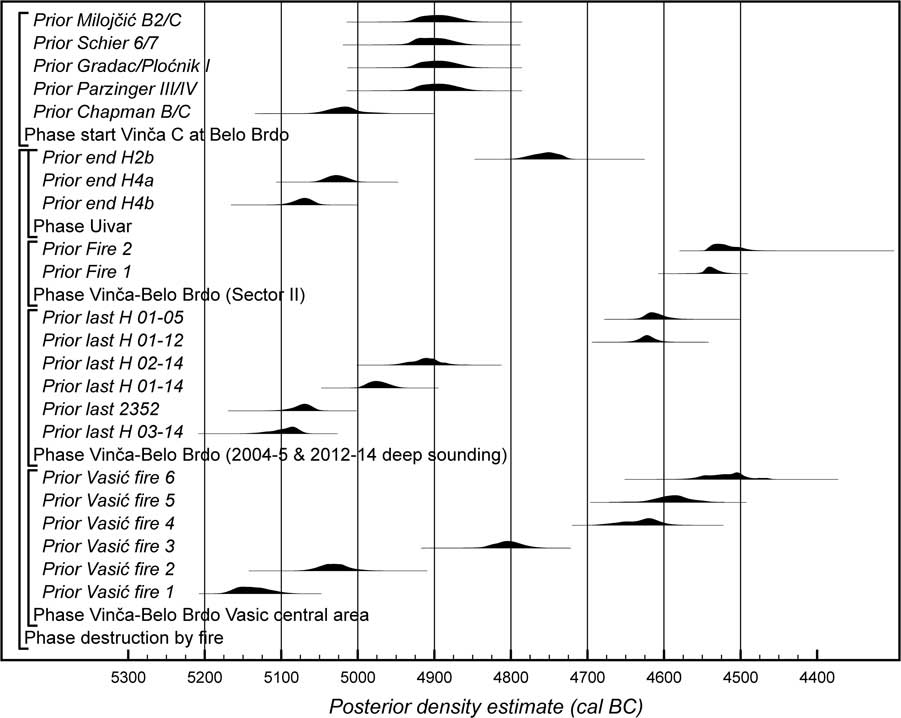
Figure 16 Probability distributions for the destruction by fire of dated buildings from Vinča Belo Brdo and Uivar, and for the onset of Vinča C pottery at Belo Brdo (in various typological schemes). Posterior density estimates are taken from the models defined in Figures 3–8, Tasić et al. (Reference Tasić, Marić, Penezić, Filipović, Borojević, Borić, Reimer, Russell, Bayliss, Barclay, Gaydarska and Whittle2015: Figure 8), and Schier et al. (Reference Schier, Draşovean, Bayliss, Gaydarska and Whittleforthcoming: Figures 6.9 and 6.12–6.22), and that illustrated in Tasić et al. (Reference Tasić, Marić, Bronk Ramsey, Kromer, Barclay, Bayliss, Beavan, Gaydarska and Whittle2016: Figure 17).
Once again, this raises important and difficult questions about the significance of both burnt and unburnt houses. We can say comparatively little about the early burnt houses in our third strand—the new deep sounding—because of the very restricted area uncovered. Other ToTL project modeling suggests, with reference to the tell at Uivar, western Romania, and using ethnographic analogy (Schier et al., forthcoming), that early houses might have been deliberately destroyed by fire to create history and renown. That could apply here too, given the comparatively short durations estimated for the houses in question. The suggestion would be strengthened if we could be more precise about the dating of the earliest burnt houses detectable in the Vasić sequence, using for example the scheme devised by Blaženka Stalio (Reference Stalio1968, Reference Stalio1984; Tasić et al. Reference Tasić, Marić, Penezić, Filipović, Borojević, Borić, Reimer, Russell, Bayliss, Barclay, Gaydarska and Whittle2015, Reference Tasić, Marić, Bronk Ramsey, Kromer, Barclay, Bayliss, Beavan, Gaydarska and Whittle2016), but as we explain elsewhere, that is difficult (Figure 17). It need not be the case that every house burning was deliberate, and a wide range of motives and situations can be suggested (Tasić et al. Reference Tasić, Marić, Penezić, Filipović, Borojević, Borić, Reimer, Russell, Bayliss, Barclay, Gaydarska and Whittle2015).

Figure 17 Schematic diagram for the chronology of Vinča-Belo Brdo showing the houses excavated in the 2002–2004 and 2012–2014 deep sounding (Figures 3–8) and Sector II (Tasić et al. Reference Tasić, Marić, Penezić, Filipović, Borojević, Borić, Reimer, Russell, Bayliss, Barclay, Gaydarska and Whittle2015: Figure 8), the building horizons from the Vasić excavations reconstructed by Stalio (Reference Stalio1984), principal episodes of burning recorded in section in the central part of the Vasić excavations (Borić 2015: Figure 4; Tasić et al. Reference Tasić, Marić, Bronk Ramsey, Kromer, Barclay, Bayliss, Beavan, Gaydarska and Whittle2016: Figure 17), dates for Starčevo features at the base of the tell (Figure 3; Tasić et al. Reference Tasić, Marić, Bronk Ramsey, Kromer, Barclay, Bayliss, Beavan, Gaydarska and Whittle2016: Figure 17), dates for the earliest Vinča occupation in profile P1/2011 (Figure 12), and date estimates for the main chronological schemes for Vinča ceramics (Tasić et al. Reference Tasić, Marić, Bronk Ramsey, Kromer, Barclay, Bayliss, Beavan, Gaydarska and Whittle2016: Figure 17).
Although correlating the sequence of building horizons suggested for the Vasić sequence with particular episodes of burning is problematic, we may be able to obtain some indication of the temporal range of burning in this long profile using the sections through the central area of his excavations drawn in the 1970s (Borić Reference Borić2015: Figure 4). We have identified six major episodes of burning in this section that probably relate to the destruction of buildings by fire (there are a number of other episodes of burning apparent in this section, but these are of a smaller scale and so it is not clear whether these represent the truncated remains of burnt houses or lesser features such as ovens). Since this section has been tied into the relative heights of the Vasić excavation, it is possible to use the age-depth model for that sequence (Tasić et al. Reference Tasić, Marić, Bronk Ramsey, Kromer, Barclay, Bayliss, Beavan, Gaydarska and Whittle2016: Figure 17) to estimate the dates of these burning episodes (Figure 16; Table 4).
Table 4 Highest posterior density (HPD) intervals for episodes of burning identified in the central section of the Vasić excavations (derived from the model illustrated in Tasić et al. Reference Tasić, Marić, Bronk Ramsey, Kromer, Barclay, Bayliss, Beavan, Gaydarska and Whittle2016: Figure 17).

Over the first 300 yr of the settlement, we can identify six separate episodes of burning that probably relate to the destruction of houses by fire, and over the last 150 probably another six (Vasić fire 5 may be the same as Fire 2 found in Sector II). In contrast, only Vasić fire 3 falls in the 250 yr following 4900 cal BC (in four of the major ceramic schemes, following the introduction of Vinča C pottery; Figures 16–17). The numbers of burnt houses so far dated (and unburnt houses so far identified) are too low to be statistically significant, but the span of time represented by the unburnt houses 01–03/13 in the new deep sounding, from between 4955–4870 cal BC (95% probability; last H 02-14) and 4650–4595 cal BC (95% probability; last H 01-12; Figure 16), is striking. These buildings were superimposed occupying the same portion of the deep sounding. This could imply a long-lasting ownership of space in the by now densely built-up settlement, further indicating a prolonged period of continuous use of the area by the same socially or otherwise related group. The idea is additionally supported by the house durations of those structures spanning one or two generations compared to a mere decade or so for the later houses 01/05 and 01/12, destroyed in the fires at the end of the 47th century BC (Figure 14). The use of the same house location over the span of several generations is presumably a clear signal of a stable society enjoying a time without turmoil—if that is what burnt houses may imply (as we discuss below). Furthermore, the new excavation gave clear evidence of planned and deliberate—as opposed to hasty—abandonment, perhaps best illustrated in the remains of oven 01/13 found in the southwest corner of the unburnt house 03/13 (Figure 11) with its dome removed prior to the desertion and the leveling of the dwelling to make room for the next structure above it.
Wider comparison is again difficult because unburnt houses were generally not detected in the excavations by Vasić. It is possible, however, that the extended Horizon V is an equivalent phase in the middle centuries of the tell where house burning was comparatively rare (Figure 17). It has been shown elsewhere in the ToTL project that there was also a sustained period without house burning at the Uivar tell (Figure 16). These site-based episodes overlap but are not identical, beginning earlier and ending earlier at Uivar—between the earlier 51st century cal BC and the earlier 48th century cal BC. We will pursue the wider implications of this emerging pattern elsewhere.
This brings us back to the much discussed and disputed question of how to interpret burnings. There are successive episodes of burning at the top of the Belo Brdo sequence visible both in Sector II and in the deep sounding of Sector I. In these, there are houses of consistently short duration. It has been proposed that the Late Neolithic was an age of fire (Stevanović Reference Stevanović2002), but we have suggested that this may not apply to the whole period. It has also been suggested that house burnings were principally individual events, conducted by householders for social or symbolic purposes (Tringham and Krstić Reference Tringham and Krstić1990; Tringham Reference Tringham1991, Reference Tringham2005). If burning was principally symbolic, and individual (house by house), why would such embedded social practice—as seen in early levels at both Vinča-Belo Brdo and Uivar—suddenly be given up, to be abandoned for a significant period of time, and then quickly readopted? We cannot exclude the possibility of accidental burnings in a crowded settlement, but we have argued elsewhere that the burning visible in Sector II could be seen instead as evidence of hostile intent, either by insiders or perhaps more probably outsiders, given its extent, the presence of a fire victim in the earlier such context, and the short interval—only some 25 yr—between the conflagrations (fire frequency; Tasić et al. Reference Tasić, Marić, Penezić, Filipović, Borojević, Borić, Reimer, Russell, Bayliss, Barclay, Gaydarska and Whittle2015: Figure 9). Weaving the strands together certainly helps here because the proximity of the new deep sounding to Sector II makes an even broader burnt area plausible. This did not necessarily, however, extend in all directions. Burning was not seen in the upper levels of another new section (Profile 1/2011; although that too is limited in scope), approximately 20 m to the northwest of the new deep sounding. At the top of Uivar, in contrast, excavation combined with comprehensive geophysical survey suggests extensive burning at the top of the tell, which came to an end in the 47th century cal BC.
The burnt person with the burnt house 01/12, of the late 47th century cal BC, is about a century earlier in date than the woman associated with the earlier burning episode (Fire 1) towards the top of Sector II (Figure 16). There is a danger of trying to force all the evidence into a single mould. But is this an indication of the beginning of the end at Belo Brdo, at a time when Uivar appears already to have finished?
Endings
The top of the sequence is missing from the new deep sounding and house 01/04 is effectively not dated (Figure 18). Sector II especially allows us to consider not only the date of the ending of the tell, but also, by the identification of two apparently large-scale fires in swift succession in the last decades of the settlement, something of the circumstances in which it may have ended.
Estimates for the end of the tell in both the Vasić sequence and Sector II, however, agree very closely: just years apart, in the 4540s or 4530s cal BC (Tasić et al. Reference Tasić, Marić, Penezić, Filipović, Borojević, Borić, Reimer, Russell, Bayliss, Barclay, Gaydarska and Whittle2015: Figure 10; 2016: Figure 17). This appears to be the latest ending so far for a Vinča culture tell anywhere (Borić Reference Borić2015; Tasić et al. Reference Tasić, Marić, Bronk Ramsey, Kromer, Barclay, Bayliss, Beavan, Gaydarska and Whittle2016), and it is a further measure of the importance of the Belo Brdo tell that its use continued for so long, and that it may have taken dramatic events to bring it finally to an end. A clear goal for future research must be to dig a series of areas on the top of the tell away from its center, to see if there is a reverse process of spatial contraction at the end of its Neolithic life; once again, a multistranded approach is vital.

Figure 18 Probability distributions for dates for the end of Vinča occupation at Belo Brdo in different areas of the tell. Posterior density estimates are taken from the model defined in Figures 3–8 (end Belo Brdo deep sounding), and the model illustrated in Tasić et al. (Reference Tasić, Marić, Bronk Ramsey, Kromer, Barclay, Bayliss, Beavan, Gaydarska and Whittle2016: Figure 17; 1.3m), and the model defined in Tasić et al. (Reference Tasić, Marić, Penezić, Filipović, Borojević, Borić, Reimer, Russell, Bayliss, Barclay, Gaydarska and Whittle2015: Figure 8; Fire 2).
CONCLUSION AND IMPLICATIONS
This paper has presented 101 14C results from the new deep sounding at Vinča-Belo Brdo, and 222 results are now available from the tell as a whole. But it is not just the numbers of dates that are important. Every effort has been made to select suitable samples: of short life and known taphonomy, where those are available. The better the understanding of the stratigraphy, the more precise are the outcomes of formal modeling. And for an archaeological formation as potentially deep and large as a tell—in this case the largest in its whole region—multiple sampling points are clearly desirable. We cannot claim that this investigation of the chronology of the Vinča-Belo Brdo tell has been ideal, since it has simply exploited the archives that are currently available, from the different kinds and scales of excavation described above. The best recording comes only from the top of the tell and from the new deep sounding, and the placing of the latter was clearly a response to circumstances of cracking and potential collapse. Nonetheless, the combined results from the pragmatic, interwoven strategies described and discussed above have produced a radically enhanced understanding of the temporality of the tell, which builds on, rather than supplants, previous research. We knew previously that Vinča-Belo Brdo was very long-lived, but now we can time that history with much greater precision. We can assert with much greater confidence that its vertical buildup was steady and largely uninterrupted, which is all the more impressive given that the tell was expanding outwards as well as upwards. We have begun, from the work on the top of the tell and in the new deep sounding, to grasp better the fluctuations in house durations from generation to generation, and can now contrast the relative fortunes of unburnt and burnt houses. We can say much more about the timing and tempo of the ending of the tell, and about the possible circumstances in which that took place.
There is clearly still much more to do, and future research will also need to be carried out within an interwoven strategy. Results so far also serve to indicate the scale of analysis and the methods required for the future analysis of other excavated tells. They are significant not just for the understanding of Vinča-Belo Brdo itself, but also for comparison with the wider Vinča network, which the ToTL project is also investigating. Further comparison with the development of the Uivar tell and others will be given elsewhere. The ultimately desirable interweaving lies in the future, when the detailed histories of multiple tells and flat sites, both neighbors and more distant rivals, can be written into broader narratives.
ACKNOWLEDGMENTS
We would like to thank: Vuk Koldžić and Jelena Bulatović for help with sampling the animal bones; Milorad Ignjatović and Lynne Keys for administrative and other support; and Kirsty Harding for help with the figures. Excavations were funded by the Serbian Ministry of Culture, with contributions from Cardiff University and the ToTL project. The Times of Their Lives (www.totl.eu) is funded by the European Research Council (Advanced Investigator Grant: 295412), and led by Alasdair Whittle and Alex Bayliss.


