INTRODUCTION
Central Europe encompasses the area from the Rhine River basin in the west to the upper Dnieper basin in the east and stretches northwards to the Alps and Carpathians. The region can be split into the lowlands, the middle Hercynian mountains and uplands, and the Subalpine and Subcarpathian basins. Research in the Vistula valley downstream of Kraków, one of the most intensely studied floodplain areas in Poland and beyond (Kalicki, Reference Kalicki1991), has shown that central European river valleys of different types and different orders responded simultaneously to climatic changes in the late glacial and Holocene, particularly with respect to climatically driven increases in fluvial activity. This is reflected in changes in channel forms; river patterns; and sedimentation on floodplains including peat growth, cover of peats by overbank deposits, buried soils, and accumulation of large numbers of tree trunks in floodplain sediments (Kalicki, Reference Kalicki2006 and references therein).
Comparison at a regional scale, with reference to western, central, and eastern subregions, of climatic records and human impact and their influence on geomorphology and sedimentation have led to important conclusions. Phases of increased river activity (“alluviation”) occurred in various lowland valleys. Despite environmental and historical differences such as the eastward increase in climatic continentality with distance from the Atlantic, and the timing and degree of the Neolithic agrarian revolution, very significant temporal convergence of late glacial and Holocene fluvial activity is recorded in all studied piedmont, upland, and lowland river basins along a west–east transect. Climatic influence is also seen in the neoholocene (Subboreal, Subatlantic), even in areas that were also under considerable anthropogenic pressure, being permanently deforested and settled by agrarian communities; notwithstanding the numerous direct and indirect anthropogenic impacts, rivers in these areas were dominantly controlled by climatic oscillations, in particular the clustering of extreme events (Kalicki, Reference Kalicki2006).
Phases of increased fluvial activity have been important in the evolution of valleys in extraglacial areas, although they have had a lesser influence in recently glaciated areas and in areas proximal to the last ice sheet. Since the Boreal (from about 9300 yr BP), however, climatic factors have played an increasingly dominant role in influencing river dynamics (Kalicki, Reference Kalicki2006).
Human impact on the evolution of large river valleys during the last millennium, and especially within the last 500 yr, is evident from the increase in overbank sedimentation that resulted from accelerated agricultural disturbance within catchments and in lateral channel migration (Kalicki, Reference Kalicki2006).
The aim of this study is a comparison between the evolution of large river valleys (first order, flowing to the sea) and middle and small rivers (second to fourth order) during the late glacial and Holocene (Krupa, Reference Krupa2013, Reference Krupa2015; Kalicki et al., Reference Kalicki, Krupa, Przepióra, Kłusakiewicz, Kusztal, Frączek and Górska-Zabielska2016).
MATERIALS AND METHODS
An interdisciplinary approach was employed, using a wide range of methods: geologic, sedimentologic, geomorphic, geoarchaeological, cartographic, and historical. Archival sources were analysed (cartographic, historical), including data from the Archaeological Map of Poland (AZP); findings were verified in the field. The particle-size distribution of silty-clayey sediments was determined using a Mastersizer 3000 Particle Analyzer from Malvern Instruments. For sandy deposits, a sieve set in accordance with Deutsches Institut für Normung International Organization for Standardization 3310-1 and British Standard 410-1 norm (sieve size 63–2,800 μm) was used (dimensions of 200×25 mm) in conjunction with a Vibratory Sieve Shaker AS 200 basic. Textural features were evaluated using Folk and Ward’s (Reference Folk and Ward1957) distribution parameters, with the GRANULOM program (with some modifications) used for the graphic presentation of results. Thermoluminescence (TL)/optically stimulated luminescence (OSL) measurements were conducted using a Manual Reader-Analyser TL/OSL RA’04 manufactured by the MIKROLAB company (Kraków, Poland). Subsamples were irradiated in a Gamma Chamber 5000. The TL/OSL dating and sediment texture analysis were conducted in the Scientific-Didactic Laboratory Centre of the Institute of Geography of Jan Kochanowski University in Kielce (Poland). Geochemical analysis was undertaken using a portable spectrometer (Delta HHXRF Analyzer series Delta Professional). Radiocarbon and dendrochronological dating was done in the Laboratory of Absolute Dating in Skała (Poland).
STUDY AREA
The study area is located in the uplands and Hercynian mountains of southern central Poland (Figs. 1 and 2). The majority of individual research projects have been conducted in the Mesozoic margin of the Holy Cross Mountains, with a single case, in the Nida River valley near Wiślica, located in the southern part of Nida basin, between the uplands of the Wodzisław and Pińczów horsts, where Cretaceous marls are covered with Miocene (Tortonian) rocks.
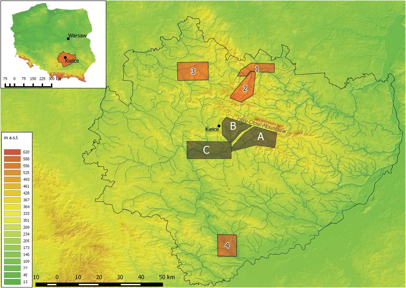
Figure 1. (colour online) Location of study areas on a digital terrain model. Previously published: Belnianka River valley (Ludwikowska-Kędzia, Reference Ludwikowska-Kędzia2000) (A); Lubrzanka River valley (Kowalski, Reference Kowalski2002a) (B); Czarna Nida valley (Krupa, Reference Krupa2013, Reference Krupa2015) (C). New research area: Kamienna River valley (1); Kamionka River valley (2); Czarna Konecka River valley (3), Nida River valley near Wiślica (4).
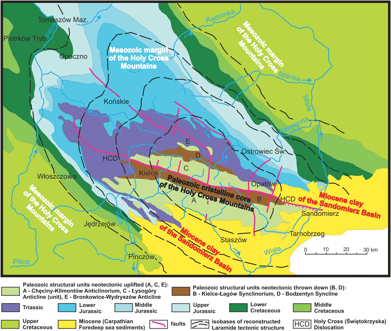
Figure 2. (colour online) Reconstruction of the Laramide morphostructure of the Holy Cross Mountains. Section of the Middle Polish Elevation on the sub-Quaternary basement (Kowalski, Reference Kowalski2002b, supplemented).
The Holy Cross Mountains have a radial drainage pattern, with the Kamienna River basin on their northern side and the Nida River to the south. This drainage arose in the early Tertiary by the creation of a broad Mesozoic upland (axis northwest–southeast) above a Palaeozoic core during the Alpine orogeny (Lencewicz, Reference Lencewicz1934; Kowalski, Reference Kowalski1988b). Rivers have incised into the Mesozoic cover and the Palaeozoic core, following tectonic structures (irrespective of rock resistance) and creating polygenetic (epigenetic-antecedent) gorges. The valley pattern in the northeastern margin of the Holy Cross Mountains (including Kamionka) is controlled by the direction of rock jointing (Kosmowska-Suffczyńska, Reference Kosmowska-Suffczyńska2000) and geodynamic joints (Kowalski, Reference Kowalski2002b).
Pleistocene valley evolution was strongly influenced by glaciation (e.g., Lencewicz, Reference Lencewicz1913; Czarnocki, Reference Czarnocki1927, Reference Czarnocki1931; Samsonowicz, Reference Samsonowicz1934; Klimaszewski, Reference Klimaszewski1952; Radłowska, Reference Radłowska1957, Reference Radłowska1960, Reference Radłowska1963; Łyczewska, Reference Łyczewska1959, Reference Łyczewska1971; Klatka, Reference Klatka1964; Różycki, Reference Różycki1964, Reference Różycki1972; Mycielska-Dowgiałło, Reference Mycielska-Dowigiałło1969, Reference Mycielska-Dowigiałło1972; Lindner, Reference Lindner1971, Reference Lindner1978, Reference Lindner1980, Reference Lindner1984a, Reference Lindner1984b, Reference Lindner2004; Bartosik, Reference Bartosik1972; Hakenberg, Reference Hakenberg1974), with a periglacial zone forming in this region on at least three occasions (Mojski, Reference Mojski2005). Significant differences in elevation have caused vertical zonality of processes (Klatka, Reference Klatka1956, Reference Klatka1968) and the accumulation of slope and fluvioglacial deposits in the periglacial valleys. Valleys in the Holy Cross Mountains therefore lack complex terrace systems (Różycki, Reference Różycki1972) such as occur in other valleys of the “periglacial area” (Mojski, Reference Mojski1993).
The southern Polish ice sheet (San I and San II glaciation) covered the Holy Cross Mountains region (Mojski, Reference Mojski2005), its relief being glacially transformed, including the erosion of gaps that were later occupied by rivers (Kowalski, Reference Kowalski1988a, Reference Kowalski2002a). At the beginning of the Mazovian interglacial period, there was erosion of the deglaciated landscape, with the deepening of subsequent valleys below the scarps of cuestas at the Mesozoic margins (Różycki, Reference Różycki1967) and the cutting of river gorges in the Palaeozoic core (Lencewicz, Reference Lencewicz1913; Kowalski, Reference Kowalski1988b). The extent of this interglacial erosion was considerable, reaching bedrock (in the valleys of the northern margin), perhaps as a result of epeirogenic uplift of the northeastern mountain foreland (Radłowska, Reference Radłowska1963; Gilewska, Reference Gilewska1972).
The extent of the Odra ice sheet was strictly relief controlled. Ice lobes were restricted to the lowest areas and valleys and basins (up to 260–270 m above sea level) were filled with fluvioglacial and fluvial deposits interdigitating with solifluction covers.
In the pre-Warta warming, incision and terrace formation occurred in the valleys: 10–12 m terraces in the Belnianka and Lubrzanka valleys (Klatka, Reference Klatka1962), terrace III (8–10 m) in the Czarna Nida valley (Krupa, Reference Krupa2013, Reference Krupa2015), terrace IV (10–15 m) in the middle Nida valley (Hakenberg and Lindner, Reference Hakenberg and Lindner1971), and terrace G III in the Kamionka valley (Lewandowski et al., Reference Lewandowski, Romanek and Studencki1975). In the late Warta glaciation, significant changes in the river network occurred in the upper Kamienna basin (Kosmowska-Suffczyńska, Reference Kosmowska-Suffczyńska1966; Lindner, Reference Lindner1970).
Vistulian cooling brought the return of periglacial conditions, with prevailing mechanical weathering and solifluction of debris covers (Klatkowa, Reference Klatkowa1955). Intensive mass movements led to the dissection of the old structural escarpments and monoclinal cuestas (Radłowska, Reference Radłowska1963), and there was accumulation of sands and gravels in valley bottoms. These fluvial sediments interdigitate with two solifluction covers, forming the terraces from the “Middle Polish” (Odranian and Wartian) glaciation (Klatkowa, Reference Klatkowa1955; Klatka, Reference Klatka1956): terrace III (7–8 m) in the confluence area of the Czarna and Biała Nida valleys and in the middle Nida valley is attributed to the Vistulian (Hakenberg and Lindner, Reference Hakenberg and Lindner1971, Reference Hakenberg and Lindner1973), whereas the deposits of terrace II (4–6 m) in the Czarna Nida valley were TL dated to 25–16 ka (Krupa, Reference Krupa2013, Reference Krupa2015). Furthermore, TL ages indicate that the 5–16 m terraces in the Belnianka valley (Ludwikowska-Kędzia, Reference Ludwikowska-Kędzia2005 and references therein) and high terraces (8–14 m) in the Lubrzanka valley (Kowalski, Reference Kowalski2002a) were formed during the pleniglacial period (Świecie stadial period, Grudziądz interstadial period). Terrace G IV in the Kamionka valley was also correlated with the Baltic (Vistulian) glaciation (Lewandowski et al., Reference Lewandowski, Romanek and Studencki1975). These terraces were cut in the Older Dryas (Klatka, Reference Klatka1968) or Allerød (Hakenberg and Lindner, Reference Hakenberg and Lindner1971), and numerous aeolian dunes were formed on them in the late glacial (Czarnik, Reference Czarnik1966; Jaśkowski, Reference Jaśkowski1996), albeit subsequently destroyed anthropogenically (Przepióra, Reference Przepióra2017). In the Younger Dryas, an extensive platform 3–4 m above river level (terrace II of Hakenberg and Lindner, Reference Hakenberg and Lindner1971, Reference Hakenberg and Lindner1973; terrace I of Krupa, Reference Krupa2013, Reference Krupa2015) was formed in several parts of the Czarna Nida valley by a braided river. A subfossil pine trunk lying in situ in sandy-gravely braid-channel sediments was dated at 10,480±70 14C yr BP (MKL-3453), 10,658–10,156 cal yr BC (Nowak, Reference Nowak2017), confirming a Younger Dryas age at a similar level in the Czarna Konecka valley. These gravel platforms were dissected at the Younger Dryas–Holocene boundary (Klatka, Reference Klatka1968; Hakenberg and Lindner, Reference Hakenberg and Lindner1971, Reference Hakenberg and Lindner1973) by rivers with large meanders (Krupa, Reference Krupa2013, Reference Krupa2015), which are preserved in the marginal parts of floodplains in numerous valleys in the Holy Cross Mountains (Kalicki et al., Reference Kalicki, Krupa, Przepióra, Kłusakiewicz, Kusztal, Frączek and Górska-Zabielska2016).
The studied valleys have in common a history of significant anthropogenic modification of the environment. Since the Neolithic there has been intensive agricultural land use (Nida) and then mining and exploitation of iron ore in these areas, first in the Roman period (Bielenin, Reference Bielenin1993; Orzechowski, Reference Orzechowski2007) and later in the Old Polish Industrial Region and the Central Industrial District. From the Middle Ages to the beginning of the twentieth century, rivers were regulated anthropogenically to power forges and mills. Therefore, in all studied valleys there are numerous artificial landforms associated with this activity, both convex (embankments, piles, etc.) and concave (excavations, pits, channels). The gradual eradication of these objects (and associated infrastructure) began later, leading to the renaturalisation of the rivers.
STRUCTURE AND AGE OF TERRACES AND FLOODPLAINS—SELECTED VALLEYS
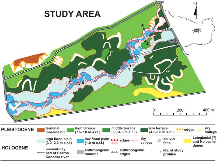
The study region in the upper Czarna Konecka River valley is located downstream of Stąporków (Fig. 1). In the upper reaches, this subsequent valley runs along an erosional depression between Mesozoic hills. During the Middle Polish (Odranian and Wartian) glaciation (Gowarczów phase), the study area was in a proximal proglacial location, and an ice-dammed lake formed (Lindner and Fedorowicz, Reference Lindner and Fedorowicz1996; Fig. 3). This has left glaciolacustrine deposits on the erosional platforms of erosion-accumulation terraces (profiles 5 and 2), but only in the eastern part of the study area. In the western part, near a morainic hill (kame?) called Ostre Górki, terraces are of the accumulation type and are composed of thick series of sandy channel deposits. After the retreat of the ice sheet and draining of the lake, the formation of the upper Czarna Konecka River valley began. The river has cut into glaciolacustrine deposits that are preserved on the erosional platform of the middle terrace (Fig. 4).

Figure 3. (colour online) Detailed geomorphic map of the Czarna Konecka River valley between Janów and Wąsosz Stara Wieś (Kusztal, Reference Kusztal2016).

Figure 4. (colour online) Lithology, grain size, and Folk-Ward distribution parameters of sediments and petrographic composition of gravels at profile 2 (middle terrace).
The valley can be divided into morphological levels of different age and structure (Kalicki et. al., 2016; Fig. 3). First, the Vistulian (?) high (cut-and-fill) terrace, approximately 7.0–7.5 m above river level, is composed of sandy braided river channel sediments (profile 5). The Vistulian (?) middle terrace (4.5–5.0 meters above river level [m arl]) is also of cut-and-fill and braided river origin (profile 2). Two series, of differing ages and origins, can be distinguished within the middle terrace in profile 2 (Fig. 4). The lower series consists of cryoturbated layers of clayey and sandy glaciolacustrine deposits. The upper series is composed of braided river channel alluvia in the form of two fluvial members. Sandstone is dominant in the petrographic composition of gravels in both members, but the content of crystalline rocks is higher in the basal lag deposits of the lower member. This indicates the reworking of fluvioglacial sediments into the alluvia of this terrace (Kalicki et al., Reference Kalicki, Krupa, Przepióra, Kłusakiewicz, Kusztal, Frączek and Górska-Zabielska2016).
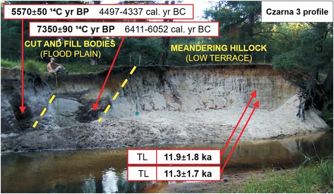
The low terrace (~4.5–3.0 m arl), of late glacial age, was formed by a meandering river (profile 3). Relatively narrow high (2.0–3.0 m arl) and low (1.0 m arl) strips of floodplain extend along the river. Sediments in these two levels show a clear facies differentiation of typical meandering river sediments. Lateral channel migration has created a meander-core “hillock” (profile 3) and bodies of Holocene cut-and-fill sediment (Fig. 5). Two of these have been dated to the early (7350±90 14C yr BP [MKL-3029], 6411–6052 cal yr BC) and late Atlantic (5570±50 14C yr BP [MKL-2983], 4497–4337 cal yr BC) (Kalicki et al., Reference Kalicki, Krupa, Przepióra, Kłusakiewicz, Kusztal, Frączek and Górska-Zabielska2016).
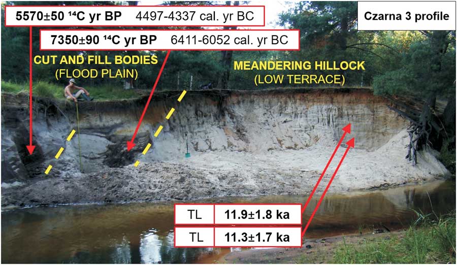
Figure 5. (colour online) Late glacial meander core and the Atlantic cut-and-fill alluvial bodies in the Czarna Konecka valley bottom (profile 3).
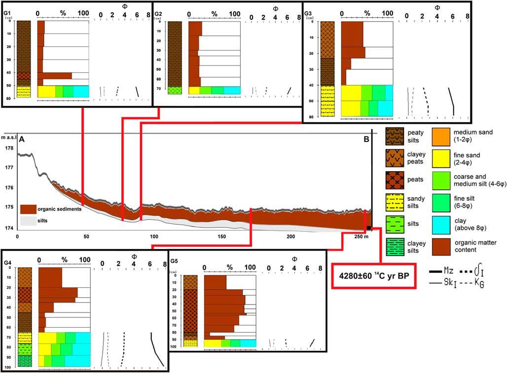
There are numerous subfossil tree trunks in both the channel sediments (profile 3) and abandoned channel fill (profiles 4 and 1). Some of these trees were 14C dated at 2610±40 14C yr BP (MKL-2984), 849–750 cal yr BC (profile 4); and 1700±40 14C yr BP (MKL-2862), 240–420 cal yr AD (profile 1) (Kalicki et al., Reference Kalicki, Krupa, Przepióra, Kłusakiewicz, Kusztal, Frączek and Górska-Zabielska2016). They belong in the beginning of the Subatlantic and the late Roman period and were deposited at the limit between channel deposits and sandy bars in the first stage of abandoned-channel filling. Oxbow-lake fills (profiles 4 and 1) show distinct variation of sedimentation types, in relation to changes in the frequency of flooding during the Holocene (Fig. 6). Changes of this type were 14C dated in profile 4 at 2470±60 14C yr BP (MKL-3031), 772–413 cal yr BC and 1410±70 14C yr BP (MKL-3030), 567–672 cal yr AD—the beginning and end of peaty silts accumulation, respectively—and in profile 1 at 630±60 14C yr BP (MKL-2861), 1270–1420 cal yr AD when peats were covered with levee deposits (intercalations of sands and silts). The last age could be connected with increased Medieval anthropogenic modification of the drainage basin and valley floor but also with a clustering of catastrophic events during the Little Ice Age. Archaeological data (AZP) indicate that settlement encroached onto the valley floor (floodplain) only in modern times. In recent centuries, the valley has been transformed anthropogenically as is documented by cartographic and historical data (Kalicki et al., Reference Kalicki, Krupa, Przepióra, Kłusakiewicz, Kusztal, Frączek and Górska-Zabielska2016).
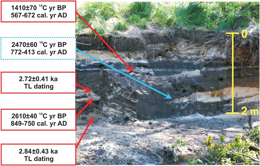
Figure 6. Variation of sedimentation type in oxbow-lake fill at profile 4, reflecting increases (red box) and decreases (dotted blue box) of fluvial activity. (For interpretation of the references to colour in this figure legend, the reader is referred to the web version of this article.)
The study section of the upper Kamienna River is located between Skarżysko-Kamienna and Marcinków, within the Rydno Archaeological Reserve, in which there are Palaeolithic hematite mines. The course of the Kamienna valley here is controlled tectonically. There are two Pleistocene terraces (from the Oder and the Vistulian glaciations) built by sandy-gravel braided-river deposits. Dunes and windblown sandy covers overlie buried soils on these terraces. The evident increase of aeolian activity could have resulted from climatic (late glacial) and anthropogenic (Holocene) factors.
The incision into the Vistulian terrace started during the late-glacial period, since the oldest palaeochannel on the floodplain has been dated at 9250±60 14C yr BP (MKL-1363), 8630–8300 cal yr BC (Marcinków II site/profile K4, K5-K8) (Barwicka, Reference Barwicka2011; Barwicka and Kalicki, Reference Barwicka and Kalicki2012, Reference Barwicka and Kalicki2013). The extensive (150–750 m wide) Holocene floodplain creates a single morphological level resulting from lateral migration of the river. It has a very complex structure with several sediment bodies of different ages and facies (overbank and channel deposits), with an overall fining-upward sequence, all typical of a meandering river.
Because of lateral migration by the river, numerous subfossil trees (known as “black oaks” in Polish) occur in the floodplain alluvium. Two of these were radiocarbon and dendrochronologically dated at 2020±40 14C yr BP (MKL-1371), 120–70 cal yr AD (Marcinków III site; Barwicka and Kalicki, Reference Barwicka and Kalicki2013) and 186–45 cal yr BC (Marcinków IV/K 7), respectively (Fig. 7). The entrainment of these trees in the floodplain sediments took place during a phase of increased river activity during Roman times. This phase (2.2–1.7 ka BP) is very well represented throughout the upper Vistula River basin (Kalicki, Reference Kalicki1991, Reference Kalicki2006; Kalicki and Krąpiec, Reference Kalicki and Krąpiec1996). A buried soil along the river channel (Fig. 7), dated at 730±90 14C yr BP (MKL-1362), 1150–1420 cal yr AD (Marcinków I site/K3–8), indicates an increase in vertical accretion in recent centuries triggered by human impact and flood events during the Little Ice Age (Barwicka and Kalicki, Reference Barwicka and Kalicki2012, Reference Barwicka and Kalicki2013).
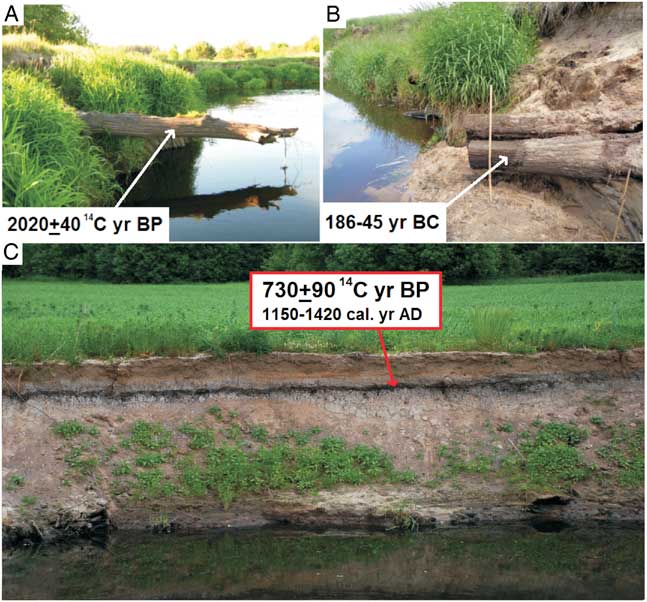
Figure 7. (colour online) Roman subfossil trees, radiocarbon (A) and dendrochronologically (B) dated, and Medieval buried soil (Marcinków I) (C) in the upper Kamienna River alluvia (photo 2011 and 2015).
The Nida River valley near Wiślica has a completely different structure. It is located in the southern part of Nida basin, where Cretaceous marls are covered with Miocene (Tortonian) rocks. In relief, the most important structure is an anticline and syncline of gypsum with karstic phenomena and gypsum domes (Bąbel, Reference Bąbel2006a, Reference Bąbel2006b). Along the alignment of the anticline were formed inversion karst basins occupied by swamps and bogs lying directly on Cretaceous marls. On the syncline were formed sinkholes and dry karstic valleys, such as at Skorocice (Flis, Reference Flis1954).
The marls at Gorysławice and the gypsum of the Wiślica anticline form the eastern limit of the subsequent Nida valley in the study area. The western slope of the valley is rectilinear and steeper than the eastern one and is covered with loess deposits. The flat valley bottom has a width of 1–3 km. It is asymmetric, with a wide and swampy left side and narrow right side (Fig. 8).
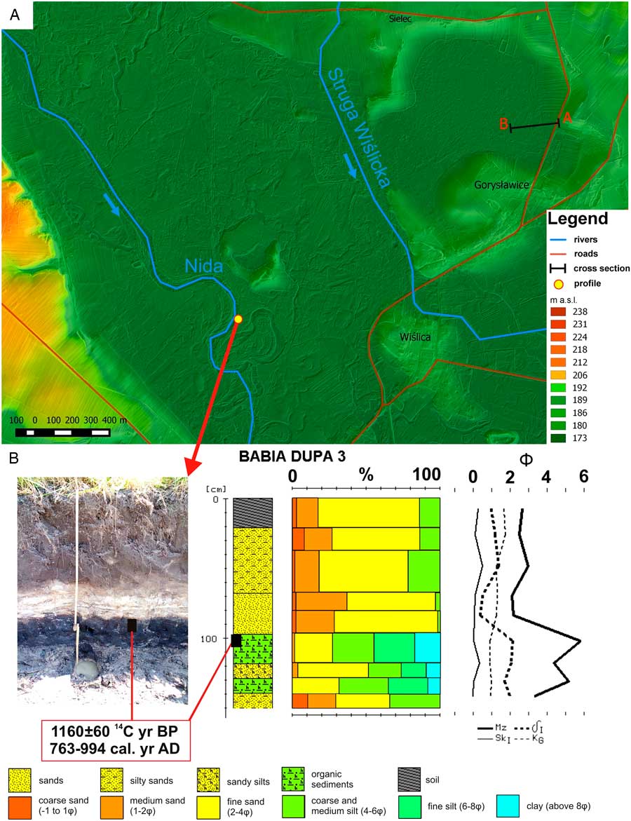
Figure 8. (colour online) (A) Digital terrain model of the Nida valley near Wiślica, with the location of study cross section A–B (see Fig. 9) and profile. (B) Lithology, grain size, and Folk-Ward distribution parameters of Nida River sediments at Babia Dupa 3 profile. Folk-Ward’s distribution parameters: δI, standard deviation (sorting); KG, kurtosis; SkI, skewness; Mz, mean diameter (Malęga, Reference Malęga2016).
Within the valley bottom on a single morphological level the following occur:
A “flat” above a karstic depression along the line of a gypsum anticline (Flis, Reference Flis1954). The karstic depression, near Gorysławice (north of Wiślica), has a radius of about 300 m and is connected by a “gap” (about 400 m wide) to the southwest with the Nida River floodplain. Boreholes reveal a cover of calcareous silts with molluscs and localized occurrences of peaty silts (near the valley slope) and peats (distant from the slope). The thickness of organic sediments increases towards the central part of the depression and the axis of the Nida valley. The bottom of this stratum was radiocarbon dated at 4280±50 14C yr BP (MKL-3131), 3027–2857 cal yr BC (Fig. 9). This may indicate the presence of an episodic stagnant-water lake or pond here. Peat bogs and swamps with small ponds (“‘water windows”‘) have occurred here from the Subboreal until the present day. No traces of river flow were found within the depression.
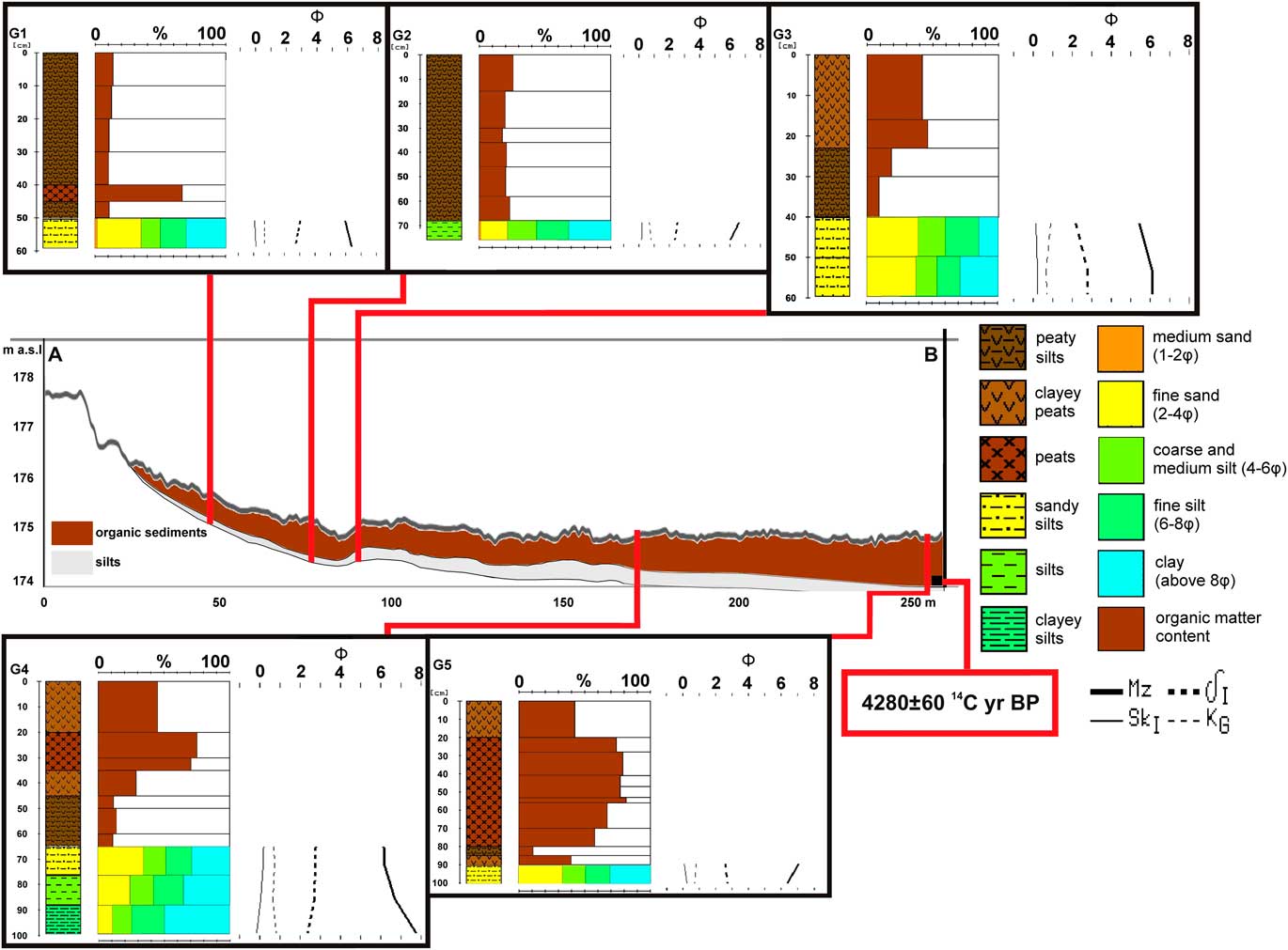
Figure 9. (colour online) Geologic section A–B across the karstic depression (see Fig. 8). Folk-Ward’s distribution parameters: δI, standard deviation (sorting); KG, kurtosis; SkI, skewness; Mz, mean diameter (Malęga, Reference Malęga2016).
The alluvial plain formed by the Nida, probably with the several cut-and-fill sediment bodies of different ages, represents changes of river pattern during the late glacial and Holocene. This complexity is evidenced by oxbow lakes preserved within the fluvial archive. There are at least two generations: an older one, preserved in the form of linear elongated swamps, with fairly straightforward courses, that may suggest an anastomosing channel pattern of the Nida; and a younger one in the form of palaeomeanders preserved along the modern riverbed. The alluvia are clearly facies differentiated. Three profiles were studied in an outcrop about 30 m long on the left side of the floodplain near the Babia Dupa gypsum dome (Fig. 8). Organic sediments covered with overbank deposits occurred in the BD 3 profile. The organic layers are probably palaeochannel fills, with a buried soil at the top. According to radiocarbon dating, overbank deposition started about 1160±60 14C yr BP (MKL-3132), 763–994 cal yr AD. The overbank sediments generally have a fining-upward sequence, with two members that were accumulated during different phases of accretion (Fig. 8). This indicates that this accumulation can be connected with a meandering river regime (the final stage of evolution of the Nida River). The presence of a buried soil also indicates changes in fluvial activity and in the rate of overbank accumulation during the last millennium.
Monoclinal gypsum elevations and gypsum “tumuli” give rise to small islands rising above the valley floor. These have been settled since the Neolithic (Kalicki et al., Reference Kalicki, Krupa, Przepióra, Kłusakiewicz, Kusztal, Frączek and Górska-Zabielska2016). Later, small fortified settlements (at the end of the ninth century/beginning of the tenth century AD) and strongholds (in the eleventh century AD) were located on the dome at Wiślica.
ANTHROPOGENIC MODIFICATION OF CHANNELS, FLOODPLAINS, AND DISCHARGE—SELECTED VALLEYS
The Kamionka is a small (17 km long), right-bank tributary of the Kamienna. Its catchment (about 107 km2) lies within the area of the Old Polish Industrial Region and Central Industrial District, where mining and an iron-ore industry developed from the late Middle Ages. This caused significant anthropogenic modification of the environment in recent centuries (e.g., embankments, channels, and mine shafts). The Kamionka was used as a source of energy for many blacksmith shops and forges and later for water mills. More than a dozen forges and (later) mills functioned in the catchment during different periods, about seven of them on the Kamionka River near Suchedniów (Przepióra et al., Reference Przepióra, Frączek, Król and Kalicki2016). Therefore, the middle section of the valley was the most anthropogenically modified, especially from the seventeenth to the second half of the twentieth century (Przepióra, Reference Przepióra2017). This is very well documented by historical, cartographic, photographic, and other data since the nineteenth century, and nowadays from the ruins of buildings on riverbanks, embankments, reservoirs, millraces, shafts, and many other types of infrastructure (Piasta, Reference Piasta2012; Przepióra, Reference Przepióra2017).
About 50% of the river’s length in the lower and middle sections was regulated (Przepióra, Reference Przepióra2017), and numerous artificial channels and millraces caused changes to the river pattern. In numerous reaches, the Kamionka had an anastomosing (multichannel) pattern because water flowed simultaneously along two or more riverbeds: natural and anthropogenic. These “anthropogenic anastomoses” are visible on historical maps from the last two centuries. Downstream of an old mill at Baranów, additional channels that are still active nowadays can be seen (Fig. 10). Some industrial developments have also led to the disappearance of smaller streams in the twentieth century (e.g., Pstrążnica; Przepióra, Reference Przepióra2017).
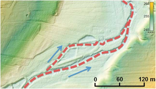
Figure 10. (colour online) Present-day anthropogenic channel multiplication in the reach of the Kamionka River near Baranów (on digital terrain model). The river flows simultaneously in natural and anthropogenic channels (multichannel system).
Numerous dams and water reservoirs were also built, as part of the hydro-infrastructure driving nearby forges (Fig. 11): the “anthropogenic small-scale water retention system’ (ASWRS). All these human activities changed water circulation in the Kamionka drainage basin—stabilizing discharges and slowing down water circulation.
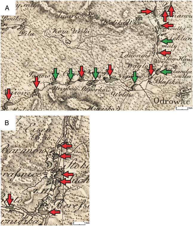
Figure 11. Anthropogenic industrial ponds on the upper Czarna Konecka River (A) and the Kamionka and Łosiennica Rivers (B) from the historical map Heldensfeld and Benedicti from Reference Heldensfeld and Benedicti1808 (red arrow indicates presently nonexistent; green arrow indicates presently existing). (For interpretation of the references to colour in this figure legend, the reader is referred to the web version of this article.)
Analogous changes occurred in the Czarna Konecka valley, where, according to historical data, an iron industry developed from the fifteenth century (Fajkosz, Reference Fajkosz1978). Numerous forges with industrial ponds (Fig. 11) and artificial channels were built on the river (Bielenin, Reference Bielenin1993). From the end of nineteenth century/beginning of the twentieth century, this infrastructure was used by mills and sawmills (Solarz, Reference Solarz2005). This ASWRS replaced a natural system associated with beaver activity, the scale of which must have been very large, as confirmed by a record of Polish King Leszek Biały for Sobków village related to beaver trappers on the Czarna River from 1224 (Piekosiński, Reference Piekosiński1876).
After the collapse of the industries, most of the small reservoirs disappeared, and larger flood-control reservoirs have been created in their place. One of these, Suchedniów Lake, has been very full in recent years (Górski et al., Reference Górski, Bąk and Szeląg2012; Przepióra, Reference Przepióra2017). Their construction contributed to the emergence of catastrophic flash floods on the river caused by the failure of hydrotechnical facilities, such as floods in Rejów (in 1939) and Suchedniów (in 1974). In 1974, the flood wave left very coarse deposits in the riverbed, and the later anthropogenic floods, related to flood-control measures, formed very coarse gravel bars in a 300 m reach downstream of the dam (Przepióra, Reference Przepióra2017).
The collapse of anthropogenic water-retention structures also took place in the Czarna Konecka River valley. There were anthropogenic flash floods here because of the breaking of dams during natural rainfall-induced floods, in 1903 (Wąglów), 1939 (Wąsosz, Janów), the 1970s (Małachów), 1976 (Janów), and 1997 (Janów, Małachów). Such a high-energy discharge caused, in a few hundred meters downstream of a broken dam at Wąsosz Stara Wieś village, the accumulation of very coarse-grained (sandy gravel) channel sediments with artefacts. The thickness of this cut-and-fill body reaches 2 m in the middle floodplain, whereas on the lower floodplain this member is about 30 cm thick and lies in superposition above older deposits (Nowak, Reference Nowak2017).
Intensive basal erosion in reaches upstream of un-rebuilt dams has resulted in incision of the riverbed, which reached about 2.5 m in the 1993–1995 period upstream of Małachów. Material eroded from this section was deposited (100,000 m3) downstream of Sielpia reservoir, the area of which has decreased by about 13% (Grzyb et al., Reference Grzyb, Zięba, Piotrowicz and Pochołowiecka–Grzyb1995). This erosion resulted in the formation of incised meanders with very slow lateral migration, fixing a single-channel meander system.
GEOCHEMICAL CHANGES OF VALLEY BOTTOM SEDIMENTS—SELECTED VALLEYS
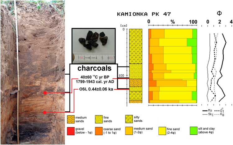
In the middle section of the Kamionka, lacustrine (ponds, abandoned channels) and fluvial sediments (mainly overbank deposits) and layers of slags and charcoal are involved, respectively. They are related to the activity of forges, as confirmed by OSL dating, 0.44±0.06 ka (UJK-OSL-68), and 14C dating, 40±80 14C yr BP (MKL-3250), 1799–1943 cal yr AD, and contained fragments of contemporary ceramics (Fig. 12). At the same time, slag layers in the lacustrine deposits could have caused an increase in iron content, which was not found in other facies of the floodplain sediments (Przepióra, Reference Przepióra2017; Fig. 13).
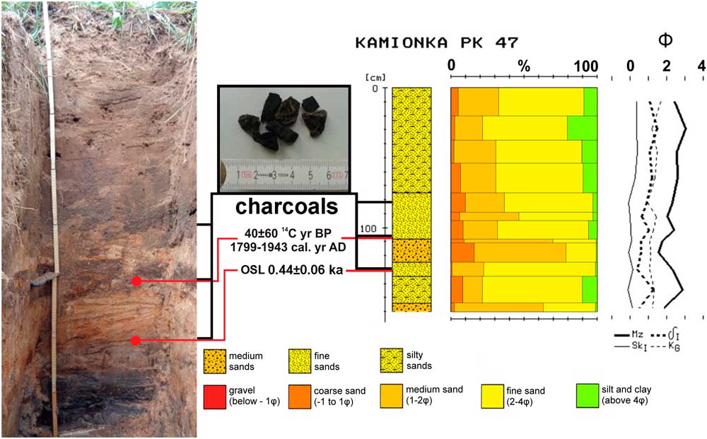
Figure 12. (colour online) Lithology, grain size, and Folk-Ward distribution parameters of Kamionka River sediments near Jędrów with optically stimulated luminescence and 14C dating (Przepióra, Reference Przepióra2017). Folk-Ward’s distribution parameters: δI, standard deviation (sorting); KG, kurtosis; SkI, skewness; Mz, mean diameter.
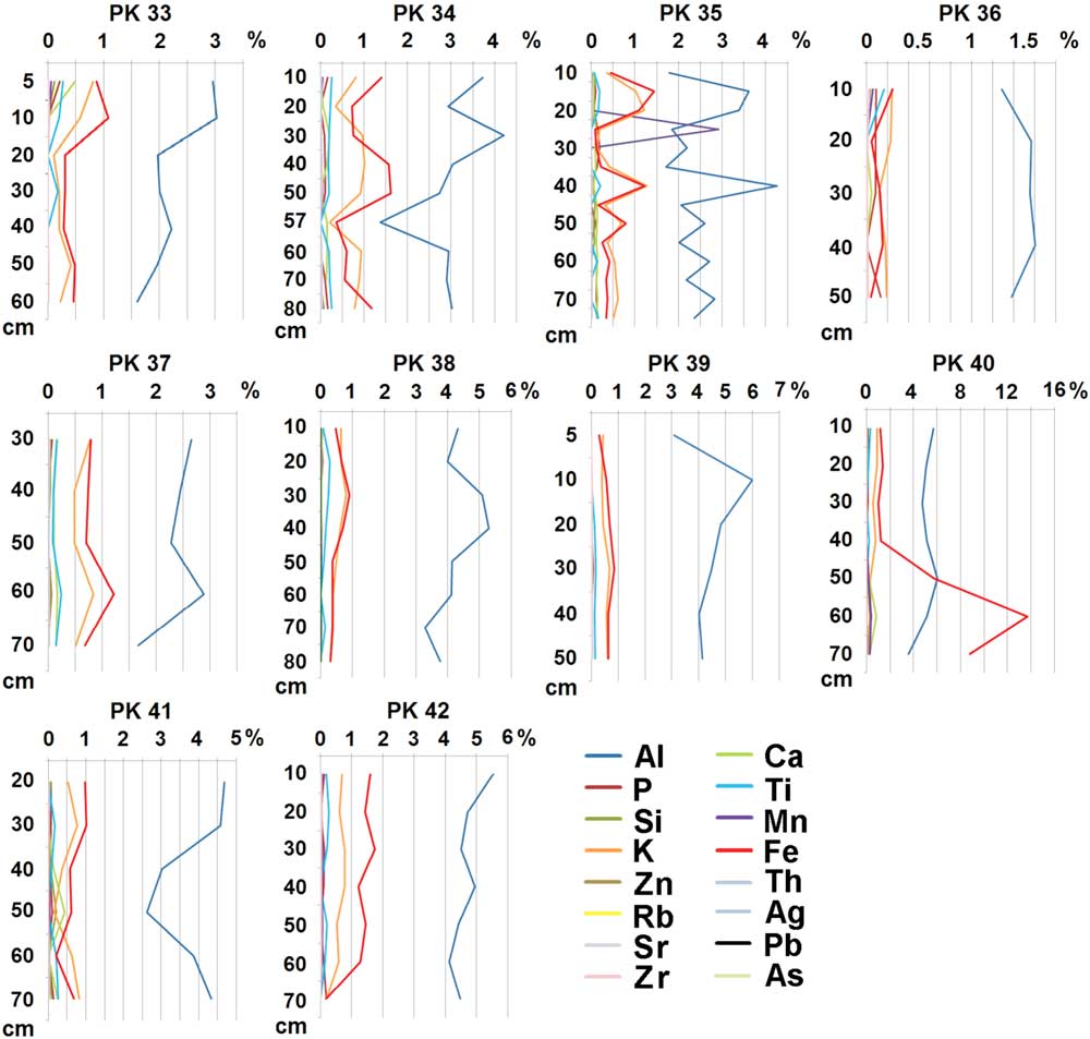
Figure 13. (colour online) Geochemical profiles of Kamionka River floodplain deposits. Note an increase of Fe content only in lacustrine sediments of the old pond (PK 40 profile) (Przepióra, Reference Przepióra2017).
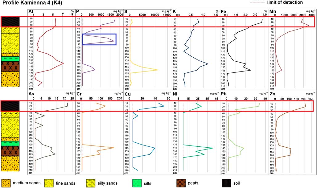
Sedimentologic and geochemical traces of human activity have also been identified in Kamienna River deposits. These include charcoal fragments (up to ~3 cm in diameter) in the channel deposits near Olszanka and chocolate flint artefacts and slag intercalations close to the Medieval forge at Marcinków. The principal effect of prehistoric settlement was an increase of phosphorus content in overbank deposits (profile K4, 60–80 cm depth), whereas modern human activity has caused geochemical changes in topsoil, with increased concentration of phosphorus, iron, manganese, and trace elements such as arsenic, chromium, copper, zinc, lead, and nickel (profile K4, 0–20 cm depth; Fig. 14) within the Kamienna floodplain as a whole. The highest accumulation of heavy metals, especially chromium, copper, and arsenic, occurs in flood channel fills or young oxbow-lake fills (Kłusakiewicz et al., Reference Kłusakiewicz, Kalicki, Horák, Przepióra, Frączek and Chrabąszcz2017).

Figure 14. A record of prehistoric (blue box) and historical (red box) anthropogenic geochemical changes in overbank deposits of the Kamienna River floodplain near Marcinków (by J. Horák, E. Kłusakiewicz). (For interpretation of the references to colour in this figure legend, the reader is referred to the web version of this article.)
DISCUSSION
Some terraces from the Oder and Vistulian glaciations occur in the valleys of the Holy Cross Mountains. Valley floors have complex structures, especially in the karstic region (Nida) where the valley bottom consists of fluvial segments and karstic depressions. Floodplains have a highly complex structure, with several alluvial bodies of different ages. Both their morphology and sedimentology show clear traces of phases of increased fluvial activity during the Holocene, in which several types of processes occurred: channel changes (cutoffs), changes of sedimentation type (covering of organic sediments by overbank deposits), and deposition of tree trunks.
In the valleys of the Holy Cross region, the first changes of sedimentation type that can be linked to human activities are dated to the last millennium. A surge in nonarboreal pollen concentration of more than 50% was recorded in pollen diagrams (Szczepanek, Reference Szczepanek1961, Reference Szczepanek1982). Deforestation caused an increase in the overbank sediment accumulation rate. The first group of sedimentation changes coincides with the dates from the Czarna Nida valley (Zbrza 1: 1230±70 14C yr BP [MKL-1064], 660–900 cal yr AD; Łaziska 2: 1190±35 14C yr BP [MKL-2855], 765–902 cal yr AD) (Krupa and Kalicki, Reference Krupa and Kalicki2012; Krupa, Reference Krupa2013, Reference Krupa2015; Kalicki et al., Reference Kalicki, Krupa, Przepióra, Kłusakiewicz, Kusztal, Frączek and Górska-Zabielska2016) and from the Nida valley (1160±60 14C yr BP, 763–994 cal yr AD), and these refer to the spread of Slavic settlement after the Great Migration Period (fifth and sixth centuries AD). The second, somewhat younger, coincides with the beginning of the Little Ice Age, which is discernible in the upper Kamienna valley (730±90 14C yr BP, 1150–1420 cal yr AD), in the upper Czarna Konecka valley (630±14C yr BP, 1270–1420 cal yr AD), and in the Wierna Rzeka valley (610±40 14C yr BP [MKL-3133], 1290–1409 cal yr AD). This can be correlated with Medieval settlement. Changes of this type are also known from adjacent valleys—for example, from the Belnianka valley, where overbank deposition stopped peat growth in abandoned channels (Niwy: 1300±120 14C yr BP, 474–995 cal yr AD; Napęków: 270±60 14C yr BP [Gd-7262], 1460–1807 cal yr AD; Czaplów: 140±120 14C yr BP [Gd-10455] after 1617 cal yr AD), the increased accumulation rate of levee deposits led to the formation of peat bogs in back swamps (Pipała-Smyków: 990±140 14C yr BP [Gd-9610], 722–1276 cal yr AD; 840±110 14C yr BP [Gd-10451], 985–1315 cal yr AD; Napęków: 770±50 14C yr BP [Gd-7263], 1161–1298 cal yr AD; Czaplów: 660±100 14C yr BP [Gd-10367], 1169–1441 cal yr AD), and soil erosion caused accumulation of colluvial deposits (Napęków: 720±200 14C yr BP [Gd-10452], 888–1530 cal yr AD) (Ludwikowska-Kędzia, Reference Ludwikowska-Kędzia2000); and also from the Lubrzanka valley, where anthropogenically dammed-lake sediments (after 1360±60 14C yr BP, 563–774 cal yr AD) and various series of overbank deposits (760±50 14C yr BP, 1165–1299 cal yr AD; 530±50 14C yr BP, 1301–1449 cal yr AD; 440±50 14C yr BP, 1405–1632 cal yr AD) were formed (Kowalski, Reference Kowalski2002a).
At a similar time, at the end of the eleventh century/beginning of the twelfth century, water mills appeared in Poland (Baranowski, Reference Baranowski1977), and the Old Polish Industrial Region, based on iron ore resources and hydropower for forges, began to develop in the Holy Cross Mountains region. This led to the construction of hydrotechnical infrastructure on many rivers (riverbed regulation, digging drainage systems and channels, millraces, ponds, etc.). As a result, an extensive ASWRS replaced the natural beaver activity. This also led to the creation of sections of anthropogenic channel multiplication along numerous rivers, where the river flowed at the same time within both its natural and artificial channels (channel, leat). Many Polish and foreign authors had already attributed a significant role in the modification of the conditions in the river valleys to mills (e.g., Sheppard, Reference Sheppard1958; Dembińska, Reference Dembińska1973; Łoś, Reference Łoś1978; Bond, Reference Bond1979; Kaniecki, Reference Kaniecki1993, Reference Kaniecki1999, Reference Kaniecki2004; Bork et al., Reference Bork, Bork, Dalchow, Faust, Piorr and Schatz1998; Brykała, Reference Brykała2003, Reference Brykała2005, Reference Brykała2009; Fajer, Reference Fajer2003; Podgórski, Reference Podgórski2004; Kobojek, Reference Kobojek2009) and to the ASWRS (e.g., Falkowski, Reference Falkowski1967, Reference Falkowski1975, Reference Falkowski1982).
In addition to changes of river channel pattern, human activity has caused anthropogenic landforms to be very common in the valleys, both accumulative (convex) (e.g., railway, road, and hydrotechnical embankments) and erosional (concave) (e.g., channels, drainage systems, leats, artificial water reservoir depressions, and quarries [sand and gravel pits]).
The activity of forges has led to the accumulation of charcoal in the overbank sediments and slag in the lacustrine sediments of now dry ponds (Kamionka valley) and in channel sediments such as in the Kamienna valley. However, although contamination by metals has been found in the entire Kamienna floodplain surface sediments in the Kamionka valley, such changes are only visible in the limnic sediments of industrial ponds. The absence of subfossil trees in the Kamionka floodplain sediments, in contrast to the numerous examples found nearby in the Kamienna and in other larger Holy Cross Mountains rivers, indicates the high planar stability of the Kamionka riverbed, which may have been associated with numerous anthropogenic channels along the river. During the Little Ice Age, with an increased frequency of extreme events, large floods covering the whole valley floor did not occur, as indicated by the absence of overbank sediment polluted by heavy metals across the whole floodplain. This probably reflects the development of the ASWRS (many ponds near the forges and mills, millraces, etc.), leading to lowered flood peaks and preventing flooding of the valley bottom. This is indirectly confirmed by historical photographs documenting settlements located at that time on the floodplain (Przepióra, Reference Przepióra2017).
At the end of the nineteenth century/beginning of the twentieth century, the activity of the forges finally came to an end, as with water mills in the middle of the twentieth century. Some of the ponds were drained, and their infrastructure was destroyed. The function of other ponds was changed to flood control and recreation. The ASWRS constructed since the Middle Ages had a beneficial effect on the regulation and speed of water circulation in the catchment area. In the twentieth century, the decay of technical infrastructure was conducive to the occurrence of catastrophic flash floods that were not present during the earlier Holocene (there is no evidence of such events in sediments or morphology). During rainfall-induced floods, there were failures of shafts and dams that led to rapid drainage of reservoirs and formed flash floods in the valley farther downstream. This kind of event occurred many times in the Czarna Konecka and Kamionka valleys. The geomorphic effects of these floods were significant, surpassing many times the effects of natural processes. These high-energy flows caused cut-and-fill accumulation of very coarse-grained channel sediments in the reaches downstream of the broken dams in these two valleys. The failure to rebuild dams in the Czarna Konecka valley led to very intensive incision of the riverbed, resulting in incised meanders and the fixing of the single channel pattern. Additionally, flood-control management reservoirs caused anthropogenic floods—for example, the overflow of Suchedniów Lake in 2010. Those floods caused the coarse grain size of present-day bars and sediments, fining with distance from the dam.
In recent decades, with the decline of industrial activity, renaturalisation processes have begun in the valleys and riverbeds. This includes the reintroduction of beavers and the rebuilding of natural small retention ponds by these animals.
CONCLUSIONS
There are various terraces from the Oder and Vistulian glaciations in the valleys of the Holy Cross Mountains, as well as complex Holocene floodplains made up of alluvial sediment bodies of different ages. From both morphological and sedimentologic evidence, there are clear traces of phases of increased fluvial activity during the Holocene. Intensive human impact, increasing since the Middle Ages, has been recorded in numerous anthropogenic landforms as well as in sediments. The development of the ASWRS, associated with forges and mills on the watercourses, resulted in changes in river pattern (anthropogenic channel multiplication) and reduction of flood stage maximum during the Little Ice Age. Following the disappearance of the ASWRS in the twentieth century, several major events took place in the Kamionka and Czarna Konecka Rivers. These events, previously unknown in the Holocene, were caused by hydrotechnical failures, leading to catastrophic flash floods, with geomorphic effects significantly exceeding those of natural processes.
ACKNOWLEDGMENTS
Studies were financed and realised within the project “Functioning of the environment of the Holy Cross Mountains region under conditions of climate changes and an increase of human impact” (No. UJK BS 612 480). The authors give special thanks to Mariusz Nowak for the extensive field work, Asst. Prof. Maria Górska-Zabielska for all petrographic analysis, and Szymon Piasta for all historical documents about Suchedniów. We would like to thank the reviewers, guest editor Prof. David Bridgland, and senior editor Prof. Lewis Owen for their substantive comments and linguistic corrections.