
1. INTRODUCTION
Since 2007, the Gabii Project has been conducting large-scale research at the ancient site of Gabii, a Latin town located 18 km east of Rome, which grew into an important centre in the Archaic period.Footnote 1 The project began with a magnetometer survey that revealed the orthogonal layout of the town (Becker, Mogetta and Terrenato, Reference Becker, Mogetta and Terrenato2009; Terrenato et al., Reference Terrenato, Gallone, Becker, Kay, Brandt, Raventós and Ghini2010; Kay, Reference Kay, Johnson and Millett2013). Based on the plan of the street network, excavations were launched in the summer of 2009, exposing a zone that includes portions of five contiguous city-blocks within a 1 ha area near the monumental core of the town (Fig. 1). One of the main research goals of the project was to shed light on the process of city formation, elucidating when and how the regular layout was created, and how its urban zoning, with clearly defined public and private spaces, developed and eventually decayed.

Fig. 1. Restored city plan of Gabii, based on the interpretation of the magnetometer survey.
Excavations in 2009–11 revealed that the town plan was laid out by the late fifth or early fourth century BC, replacing a settlement consisting of multiple isolated foci (Mogetta, Reference Mogetta and Robinson2014). The orthogonal city-blocks are occupied by a series of buildings of different function and size, with multiple phases of occupation spanning from the mid-Republican to the Imperial period, particularly in the sectors named Area B and Area C (Gallone and Mogetta, Reference Gallone and Mogetta2013; Mogetta and Becker, Reference Mogetta and Becker2014).
Excavations in 2012–15 concentrated on a city-block situated in a prominent central position, just north of the main thoroughfare that generates the urban grid, at the intersection with a road branching off from it at an odd angle and leading to Praeneste (Fig. 2). This excavation sector, named Area F, encompassed some free-standing features that had already been brought to light in the 1990s by the Soprintendenza Speciale per i Beni Archeologici di Roma (SSBAR, now Soprintendenza Speciale per il Colosseo e l'Area Archeologica Centrale di Roma, or SSCOL) at the front of the city-block. Stretches of ashlar masonry walls and pavements were visible below later concrete structures, but the limited extent of the explorations prevented a clear understanding of the phasing, as well as of the nature, scale and significance of the site (Majarini and Musco, Reference Majarini, Musco and Filippi2001). By expanding the investigation behind the front of the city-block, the Gabii Project excavations revealed the exceptional character and monumentality of the building to which the earlier features belonged. Compared with other city-blocks excavated thus far, the Area F insula stands out precisely because it is occupied by a single large complex, measuring in surface more than 2,000 m2 and subdivided into three successive terraces.

Fig. 2. Composite orthorectified aerial photograph of excavated structures, showing Area F (outlined in orange) and Area B (outlined in red).
In 2012, the excavation brought to light the open area on the upper level of the city-block, and a stretch of the road that separates Area F from Area B, which occupies the adjacent city-block to the east.Footnote 2 The space appeared delimited to the south by an impressive ashlar wall, whose position hinted at the fact that the complex continued to the south, but at a lower level. In 2013–14, the middle terrace was exposed, and a general topographic survey of all standing features was carried out. In addition, limited soundings were executed in the lower terrace, reopening previous trenches only partially excavated by the SSBAR. Finally, in 2015, the southwest corner of the building was uncovered, allowing a complete plan of the complex to be obtained.Footnote 3
Architectural remains and other built features are generally well preserved, particularly at the base of the middle terrace, whose ashlar walls were the object of two seasons of conservation work in 2015–16.Footnote 4 On the other hand, the state of preservation of the stratigraphy is not ideal. By the early Imperial period, at the latest, the monumental mid-Republican building had ceased to function according to its original design; it underwent a reorganization along with extensive spoliation, before being completely abandoned. These activities unfortunately resulted in the destruction of most of the stratigraphic evidence related to the original use and occupation of the first phase, but fortuitously the construction levels were not affected. A new complex of rooms was subsequently built on a slightly different alignment, on top of a thick levelling layer that covered most of the earlier structures. This Imperial building was considerably smaller. It gravitated towards the main thoroughfare, and featured two rows of rooms on the lower terrace and a courtyard or open space at the back, on what had been the middle terrace. Most of the occupation layers for the later phases had been excavated previously by the SSBAR, whose trenches reached the Imperial floor levels.Footnote 5
In this paper we provide a first reconstruction of the occupation sequence in Area F, concentrating on the mid-Republican phase. The subsequent phases — related to the reorganization and abandonment of the monumental complex, and to the construction and occupation of the Imperial structures along the north side of the main thoroughfare at the centre of the city — will be treated in a second paper, currently in preparation. Here we offer a detailed discussion of the architecture and stratigraphy of the original complex, which we tentatively identify as public in nature, contextualizing the results within both the history and urban development of Gabii and the broader debate on the formation of Roman Republican architecture. The conclusions highlight the importance of the new finds for our understanding of the emergence of Roman civic buildings: the Area F building represents to date one of the few examples of mid-Republican monumental architecture other than temple podia and fortifications known from Rome or other major sites in the neighbouring region. While the uniqueness of our building poses certain problems of interpretation, particularly because the main comparanda for the period are necessarily from the domestic sphere, the evidence prompts a rethinking of the relationship between private architecture and early public building. Furthermore, it invites us to reconsider the role played by Rome's neighbours in the development of new monumental canons and in the definition of ways of organizing public space.
2. PHASE ONE
The building dominates a central location within the city, on the main urban thoroughfare at the intersection of the roads from Tibur, Praeneste and Rome.Footnote 6 It occupies the width of an entire city-block (31.6 m), and is organized on a series of three artificial terraces (65 m long in total) that regularized the slope of the volcanic terrain (Figs 3, 4, 5). The construction of these terraces significantly altered the natural hydrology of the area, and thus necessitated the creation of a prerequisite infrastructure consisting of an elaborate system of subterranean drainage channels, running at an average depth of about 3 m below the surface (Fig. 6).Footnote 7 At least seven separate deep vertical shafts — regularly cut into the bedrock, and measuring on the surface roughly 1.0 m by 0.5 m — that communicate between the surface and this system have been identified, distributed throughout the complex; significant extents of the courses of several branches of these channels can be traced, and they appear to connect to the broader network of cuniculi that runs throughout the city and drained downhill, probably ultimately into the marshy valley of the Pantano Borghese.Footnote 8 Several architectural features — like the impluvia of the courtyards and the floor drains of the bathing facilities, described below — make particular use of this hydrological system, and it is likely to have been planned in conjunction with the complex as a whole. Ceramic evidence from secure contexts indicates a date for the initial construction phase of the complex around the middle of the third century BC.Footnote 9 This accords well with the general period suggested by the construction techniques employed throughout the building, namely ashlar walls in opus quadratum and unmortared semi-polygonal masonry and floors paved in a combination of tufo slabs and cocciopesto, as well as with known comparanda for the architectural features of the complex.Footnote 10

Fig. 3. Plan of the remains of Phase 1 of the Area F complex.

Fig. 4. Plan of the remains of Phase 1 of the Area F complex, with proposed reconstruction.

Fig. 5. Reconstructed plan of Phase 1 of the Area F complex.
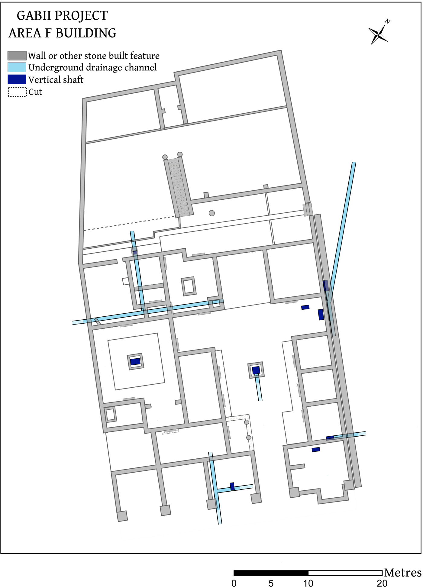
Fig. 6. Plan of the known or securely hypothesized courses of the subterranean drainage channels connected to the Area F complex.
3. LOWER TERRACE
The lower terrace was the only part of the complex that continued to be occupied well into the high empire, and it was thus profoundly impacted by the later reuse of this part of the city to serve the needs of travellers on the highway between Rome and Tibur and Praeneste.Footnote 11 While the successive reorganizations of the space complicate our understanding of the original plan and function of this part of the building, sufficient traces of the first phase have been uncovered to allow a general reconstruction. It is unclear whether the monumental portico composed of a series of ten massive tufo pillars that ran along the main road and framed the lower terrace at its southern limit in the later phases had an antecedent in the first phase, since many of the surviving pillars cannot be in their original position. But it seems probable that the portico of the Imperial building was a reconstruction of an architectural feature that belonged to the first phase, reusing its key elements with only some slight modifications and consolidations (for example, the use of new concrete bases for the old tufo pillars). A series of large rooms paved in tufo slabs opened onto the road. These rooms were laid out on either side of a broad central corridor, which defines one of the main axes of the complex and served as the entryway to the middle terrace from the main thoroughfare; this transitional space was delimited by long ashlar walls that ended in massive tufo pilasters.
The large room to the east of this corridor (Room F1-1), measuring 8.5 m by 8.5 m, was constructed within a shallow (0.5 m) terracing cut in the bedrock, against which the northern wall of the room was built in ashlar tufo blocks. Part of its southern limit extends further toward the main road than the rest of the rooms on this terrace; this irregularity — a ‘double-elbow’ disrupting the course of a linear east–west feature — is found repeated several times in the line of walls, drains and terracing cuts elsewhere in the complex. The nature and location of the entrance into this room is unclear, but there does not seem to have been direct access from the central corridor. Perhaps the southern extension served as a kind of vestibule; its eastern limit is indicated by the preserved corner, while the western limit (aligned with the western limit of rooms on the middle terrace) is hypothesized from the limits of adjacent walls. The tufo slab floor, sitting directly atop the regularized bedrock, is well preserved in places. Where the floor and northern wall are missing, two large vertical shafts (some 2.5 m deep) leading down into the subterranean drainage channels have been exposed. Another circular shaft, an opening into which appears to have been integrated into the slab floor, was plumbed to a depth of just over 7 m; it is likely to have been a well, probably related to the original phase of occupation. There are few other features that relate to the original use or organization of this room: a short stretch of wall on an east–west alignment that abuts the western wall of the room may have subdivided the space in the southwestern corner of the room.
On the other side of the corridor to the west is another square room (Room F1-2), measuring 5.8 m by 5.8 m, which opened directly onto the paved area along the road. A part of the tufo slab floor, into which a circular vertical shaft was integrated (of a narrower diameter than the wellhead in Room F1-1, but probably of similar function), is preserved in the northeastern corner of this room, as are stretches of the northern and western ashlar walls, which were reused in the concrete walls of later phases. Where it meets the paved space of the road, the western wall terminates in a tufo pier similar to those at the ends of the north–south walls of the central corridor and Room F1-1. The far western area of the lower terrace (Room F1-3) remains for the most part obscure, due to the significant extent of the reorganization of the space in later phases, which obliterated most of the original features. At the southern limit of Room F1-3, the transition from the road into this part of the complex was marked by a square pilaster located at the centre of the frontage of this room or set of rooms. The base, associated with a well-preserved stretch of the tufo slab pavement of the road and the floor of the room, is decorated with a simple moulding; a second course (a single square tufo block, now broken) is preserved, to a height of just over 1 m (Fig. 7). Traces of the ashlar walls that divided this part of the complex from the side street to the west, the middle terrace to the north, and Room F1-2 and Room F1-4 to the east survive, along with several in situ tufo slabs of the original floor, distributed throughout the space but all at the same elevation; there is, however, no clear evidence of internal walls further subdividing the space. While this may indicate that it was occupied by a single, large square open area, this kind of hypaethral courtyard, with a pillared facade supporting only an entablature, would be unusual. It seems more likely that several of the concrete structures of later phases completely replaced earlier ashlar walls. In this reconstruction, there would originally have been three open rooms of identical dimensions adjacent to the street (Room F1-2, and hypothetical Room F1-3a and Room F1-3b); the area behind these rooms and perhaps accessed from them (hypothetical Room F1-3c and Room F1-3d) would be in part the result of a compromise between the different spatial principles of the lower and middle terraces. Given the absence of evidence for a wall on its western side in this phase, Room F1-3c may have opened directly onto the western side street in a similar manner to the rooms along the main road; but this street, which in its latest Imperial phase was paved in basalt stones, has only been partially excavated. The elongated Room F1-3d would have served as a distributive space, providing an alternate access to the western courtyard on the middle terrace — presumably up a short step and into the small open-ended room (Room F1-12) — directly from the primary entryway of the building.Footnote 12

Fig. 7. Tufo pilaster (SU 5755) with moulded base, abutted by slab pavement, at the southern limit of Room F1-3.
Access to the middle terrace from the main road was gained by way of the central corridor that ran northward between Room F1-1 and Room F1-2. Its exact original design is unclear. In the later configurations of the building it was developed into a shallowly sloping ramp, ascending from the road to the south, constructed of repurposed tufo slabs; in the first phase, it is likely that a similar ramp existed, extending all the way to the middle terrace from the main road. Near the top of its ascent, this corridor was adjoined to the west by a small sunken ‘landing’ (Room F1-4), the function of which seems to have been to facilitate movement from this main entryway into the distributive space of Room F1-3d and on to the western part of the middle terrace. Of this landing a narrow pavement composed of relatively small, finely worked tufo slabs is preserved. Built into this pavement is a column base, aligned with the western wall of the corridor to the south; presumably there was a corresponding column to the north, and together these columns framed the entrance into Room F1-3d to the west (Fig. 8). The preserved pavement sits at an elevation 0.5 m above the level of the road and 0.3 m below the level of the middle terrace, and seems to represent a step that bridged the gap between the lower level of Room F1-3d to the west and the higher level of the top of the ‘ramp’ to the east. The width and grade of the entrance ramp may have been designed to accommodate wheeled traffic, as seems to have been the case in the later phases, based on the patterns of heavy wear to the tufo slabs. Thus, while the axiality of this primary entryway echoes domestic architecture (vestibulum and fauces), the types of movement that it facilitated from the main thoroughfare onto the middle terrace are more likely to have been connected to functions of a different nature to — and a grander scale than — those to be expected in the private sphere.

Fig. 8. Column base (SU 5450) integrated within the tufo slab floor of Room F1-4.
4. MIDDLE TERRACE
The fact that the middle terrace as a whole extends further south in its eastern half is probably a function of the terrain, an effort to accommodate the natural lie of the land. At the top of the lower terrace, the ramp and landing opened to the north and east onto a large open courtyard, measuring 15.4 m at its widest and 10.5 m at its narrowest by 13.5 m from north to south, around which the middle terrace was principally organized. This space was paved in tufo slabs, and was delimited to the east and west by a quasi-symmetrical arrangement of open alae and small rooms, and to the north by three larger rooms. The remains of crushed tufo floor preparation in the area between the courtyard and the rooms suggest that there was a cocciopesto pavement here covered by the eaves projecting from the roof of these rooms, which served as a transition from exterior to interior space. The relatively unweathered surface of the slabs of the alae suggests that these too were covered by a roof, as might be expected. The central area of the courtyard was heavily disturbed by the later reoccupation of the building, and it is unclear whether there was an impluvium at the centre in its original configuration, as in a typical atrium Tuscanicum, although there is evidence of channels running below this part of the courtyard into which such a basin might have drained; the courtyard is not so wide that it could not have been spanned by a compluviate roof. In its plan, with the arrangement of rooms and doorways on three sides, the courtyard creates the impression of symmetry (with the exception of the extra southern room on the east side), while at the same time disguising certain incongruities: the three small rooms on the eastern side (Rooms F1-5, F1-6 and F1-7) are paralleled by only the one long room to the west (Room F1-11), which is, however, clearly designed, with its two separate entrances, to offer a mirror image for someone standing in the centre of the open space. One of the closest parallels for this kind of large cruciform atrium, which will eventually become typical of Roman domestic architecture, comes from the Auditorium villa, only in the fourth phase of which — dated by the excavators to the middle of the third century BC — does such a space appear for the first time (Carandini, D'Alessio and Di Giuseppe, Reference Carandini, D'Alessio and Di Giuseppe2006: 225–68, Periodo 4, Fase 1).
With only one exception — Room F1-10 in the northwestern corner — the rooms that opened off the courtyard were adorned with cocciopesto floors. The surfaces of the three larger rooms (Rooms F1-8, F1-9 and F1-11) are preserved almost in their entirety, and consist of geometric patterns of white limestone tesserae in a field of crushed red ceramic. The ashlar walls of these rooms, two courses of which survive in places, were covered with red and white painted plaster, decorated — at least in Room F1-8, where it is best preserved — plainly with simple rectangular panels. The two large rooms (Rooms F1-8 and F1-9) on the north side are nearly identical, though Room F1-9 was entirely open to the courtyard, whereas Room F1-8 was entered by a door set slightly off-centre into its southern wall. The northwestern room (Room F1-10), paved in large tufo slabs, was another distributive space, providing access from the central courtyard to the rest of the building to the north through a stepped entrance in the northern wall, as well as to the adjoining room to the west (Room F1-16) across a large tufo threshold. Based on this position, and on the connectedness to important spaces that likely accommodated bathing or dining activities, as well as on several preserved features related to the storage of food and the provision of water, Room F1-10 must have been a kind of ‘service courtyard’. In the northeastern corner of the room, a cut in the bedrock accommodated a dolium (1 m in diameter), which was found in situ and seems to belong to the original phase, while in the northwestern corner, a wellhead was integrated into the tufo floor. In the southeastern corner, a feature that appears to have been an open access directly into one of the subterranean drainage channels running east–west across the middle terrace, perhaps for the purpose of disposing of refuse related to the activities that took place in the adjacent rooms, was framed by two large tufo blocks. The central part was occupied by a poorly preserved rectangular stone structure that interrupts the slab floor; its function is uncertain, but it may represent the remains of a shallow basin or pool.
To the west of the main courtyard, and accessed from the ala by way of a wide entryway, of which the massive tufo threshold remains, was a secondary courtyard, of identical dimensions to the central courtyard (13.5 m by 10.5 m). There is evidence — in the form of wear patterns on the slabs of the ala — that this entrance could be closed by a large door or gate. The central area is paved with tufo slabs, and was bordered by a cocciopesto floor surface. While at least two regular postholes were later cut into this floor, there is insufficient evidence to reconstruct a peristyle portico; it is more likely that this was an atrium Tuscanicum, with a compluviate roof supported only by beams. At the centre of this space are the remains of the corresponding impluvium, which drains into a subterranean channel and must originally have been covered by a basin. Given that the western limit has been heavily disturbed by later activity, and the western side street has been incompletely investigated, the possibility that there was another entrance into this space directly from the street cannot be excluded at the moment. In the southeastern corner of the courtyard is a small room, open almost entirely to the courtyard (Room F1-12), the northern limit of which is represented by a short, poorly preserved stretch of ashlar wall; to the south this room may have been connected by a set of steps to Room F1-3d of the lower terrace (a difference in elevation of approximately 0.7 m), and to the north it may have been mostly open to the courtyard, but its reconstruction is complicated by the reorganizations of later phases, which obliterated most of the walls and the floor surface. Southwest of this secondary courtyard is a small room (Room F1-13), measuring 5 m by 3 m; the only internal feature preserved is a rectangular structure of uncertain function in the northwestern corner, built of small tufo blocks (utilizing an ashlar block of the western wall as its western limit) and delimiting a regular cut in the bedrock. The existence of two atria in this complex is noteworthy: previously known mid-Republican comparanda are of a somewhat later date — the first phases of the Casa del Fauno, the Casa della Fontana Grande and the Casa dell'Argenteria at Pompeii, for example (all c. 175 BC) (Richardson, Reference Richardson1997: 115–16; Faber and Hoffmann, Reference Faber and Hoffmann2009) — or have hitherto proven difficult to date with any degree of certainty, such as the ‘monumental phase’ of the Villa delle Grotte at Grottarossa (middle of the third to the later second century BC) (Terrenato, Reference Terrenato2001: esp. 12ff.; De Franceschini, Reference De Franceschini2005: 86–91; Becker, Reference Becker2006: 213–20).
Moving north from the western courtyard and crossing another large stone threshold, one enters a large room paved in tufo slabs (Room F1-15), measuring 5.8 m by 8 m, adjoined by another room to the east, of slightly smaller size (4.2 m by 8 m) and comparable construction (Room F1-14). Although the southern and eastern limits of Room F1-14 are not preserved, the compact footprints of the spoliated ashlar walls are discernible in the soil upon which they were laid; notches carved into the blocks of western and northern walls where the missing walls would have intersected provide further evidence of the original dimensions. The key feature of these rooms is the unmortared brick arch structure built into the base of the ashlar wall that divides them; although the cut in the wall to accommodate the brick arch was made after the ashlar blocks were in place, the feature seems to belong to the original design and use of the space. This arch opens from a square chamber set into the floor in Room F1-15 into a channel cut in the bedrock below the floor level in Room F1-14b (Fig. 9). The north side of the channel is formed in part by the thick tufo slabs of the floor, the end of which aligns with the interior of the arch; given the spoliation of the floor in the southern part of Room F1-14b, the southern limit of the channel is only detectable from the cut in the bedrock, but here the slab floor must also have formed the side of the lower part of the channel. These are almost certainly the remains of a system for the heating of a bathing facility in Room F1-14b (praefurnium and hypocaust); from the praefurnium in Room F1-15, hot air would be circulated through the hypocaust into Room F1-14b, where there must have been a small immersion pool built over the channel.

Fig. 9. Bedrock-cut channel and brick arch (SU 5757) of the hypocaust integrated into the base of the western wall of Room F1-14.
There is some resemblance between this system at Gabii and contemporary baths in Sicily at Morgantina (Trümper, Reference Trümper and Maniscalco2015) that were known to have made use of a testudo — a semi-cylindrical metal water tank that was mounted over the heat source and connected to an adjacent pool in order to serve as a heat exchange; but with no remains of the pool preserved, this possibility must remain speculative at the moment. Based on the earliest comparanda from Sicily (the South Baths at Morgantina, c. 250–200 BC) and Italy (Phase I at Fregellae, c. 200 BC) (Tsiolis, Reference Tsiolis, Lucore and Trümper2013), the pool in Room 141-b would have measured roughly 5 m long by 1.4 m wide; such pools tend to be built against walls on at least one of both the long and the short sides, and usually vent the hot air conducted from the praefurnium through a flue at the opposite end; therefore, although the significant spoliation of this area has left no physical evidence for a wall along the southern side of the pool, it is necessary to reconstruct a small wall running east–west that would have bounded the pool and subdivided the space of Room F1-14 into areas of different functions.Footnote 13 There are other features related to the presence of water in Room F1-14b: built into the preserved portion of the slab floor is a small circular drain hole, and in the centre of the room, where the floor has been robbed, there is a small channel cut into the bedrock, which connects to the main subterranean channel that drains this area of the middle terrace; presumably the immersion pool would have overflowed directly onto the floor, and the water would have drained through these features. A niche set into the centre of the northern ashlar wall of Room F1-14b may be related to the ornamentation of the space.
While the praefurnium, in conjunction with the hypocaust and testudo, would have been sufficient to maintain the temperature of the water in the immersion pool, there must have been additional furnaces in the vicinity to heat the water to fill the pool initially; a circular feature of burnt clay constructed directly on top of the slab floor in the northeastern corner of Room F1-15 may represent the remains of one such furnace (Fig. 10), which would have held a metal boiler tank; although the water to fill the pool would probably have been carried by hand, it is possible that this tank was connected directly to the nearby pool by a pipe. There was a gap left in the northern wall of the room immediately adjacent to this feature, which was later walled in; its purpose and relationship to the furnace is unclear. In the base of the eastern end of this same northern wall, a circular hole, roughly 15 cm in diameter, has been drilled through the entire width of the tufo block; in this spatial context, it is possible that this hole accommodated a lead water pipe, which connected the adjacent boiler tank to a source of water (a storage tank) in the area immediately to the north of Room F1-15. Niches set into the northern and western ashlar walls (preserved to a height of over 1.5 m in the northwestern corner) of Room F1-15, as well as a large circular stone socket in the western wall, may be associated with other equipment that served the needs of the bathing suite.

Fig. 10. Remains of the circular feature constructed of burnt clay (SU 5720), possibly a furnace used as part of a boiler system, in the northeast corner of Room F1-15.
Access to this bathing suite would have been from the south or the east, depending on which room one was entering: the room with the pool (Room F1-14b), or the smaller room that adjoined it to the south (Room F1-14a). Given that the pool, together with the flue, occupied the width of the room on its southern side, there must have been a separate entrance to Room F1-14b from the ‘service courtyard’ (Room F1-10) to the east.Footnote 14 Room F1-14a, the function and features of which are uncertain due to its almost complete post-abandonment destruction, seems to have had two separate entrances: from the southeastern corner of Room F1-15, where a pavement at a lower level than the rest of the room is preserved, and from the small Room F1-16, which in turn was entered from Room F1-10 to the east. There are drains integrated into the floors of both spaces, and they seem to have served as anterooms related to the bathing activities that took place in Room F1-14. These distinct entrances, each ultimately accessed from a different courtyard, may have been intended for different groups of bathers.
Overall, many of the features connected to bathing and its auxiliary needs — for example, the brick arch built into a cut in the ashlar wall and the clay furnace placed on top of the tufo slab floor — seem ‘secondary’ to the construction of the associated spaces, but this is probably to be understood as a reflection of the precocious and experimental nature of the adaptation of Greek-style facilities, rather than an indication that they were not original to the conception and design of the complex. There is no evidence for an extensive reorganization of these rooms around the later addition of a bathing suite as an afterthought.
To the north, behind these rooms adjoining the two courtyards, was a long, open area running the width of the building and accessed from the rest of the middle terrace through Room F1-10. The principal feature here is a long drain of slightly concave tufo slabs, sloping downward from the eastern and western limits toward a drainage hole behind Room F1-14. Only the central area is completely preserved, but here the drain was integrated with a paved floor consisting of magnificently worked large tufo slabs as part of a small courtyard, which served as a transitional space between Room F1-10 and the upper terrace. Found in situ here was an impressively worked monolithic tufo cylinder, 0.75 m tall, with a shallow circular depression on the top face, which sits upon a raised lip in the slab floor, and thus clearly belongs to the original design of the space (Fig. 11). Based on contemporary comparanda, the object is most likely an altar.Footnote 15

Fig. 11. Cylindrical tufo feature (SU 5457), interpreted as an altar, situated on top of a raised lip worked into the tufo slab floor (SU 5467), south of ashlar retaining wall (SU 5006) dividing the middle terrace from the upper terrace.
Where the drain continues to the west from the central area, it is bounded on the north side by a line of tightly fitted orthostat tufo slabs 0.5 m tall, which serve to channel the flow of water. The associated slab floor abruptly ends at the point where the drain makes a southward double-elbow bend and the bedrock emerges at a higher and more irregular level. This seems to suggest that there was a change in the nature of the space as one moved westward from this point. To the north, between these orthostat slabs and the face of the bedrock cut that divides the middle from the upper terrace, no traces of occupation surfaces or other built features were found, only large shafts cut into the irregular bedrock, presumably related to the drainage system. This space was clearly not meant to be readily accessible, but it seems to have been visible. There are no signs that the face of the terracing cut in the bedrock to the north was concealed behind an ashlar wall, and in this area behind Room F1-15 the western wall of the complex consists of only two preserved courses of ashlar blocks that rest upon a roughly worked bedrock ledge 0.6 m tall. Thus, with exposed natural rock on two of the three sides and the presence of water features, this space may have had the appearance of a kind of ‘grotto’ (Fig. 12). It bears a vague resemblance to the two nymphea on the upper terraces at Praeneste, where there is a similar conjunction of monumental terracing, hydrological engineering and religious space,Footnote 16 but its idiosyncrasies resist interpretation at present.

Fig. 12. View looking westward of the rear area of the middle terrace, between the line of tufo orthostat slabs (SU 5580) bordering the slab drain to the south and the exposed bedrock face of the terracing cut to the north.
An alternative means of entrance into this rear area was provided by a set of three large steps at the eastern end descending from the eastern side street. At the western edge of this street, which was originally paved in a glareate surface, a line of large tufo slabs running along the eastern boundary wall of the complex served as a sidewalk, and would have facilitated the movement of pedestrians from the main thoroughfare to this secondary entrance. In time, as the functions of the building as a whole expanded, this area seems to have become even more important in connecting the middle terrace with a still broader complex of spaces in the vicinity. Around the middle of the second century BC, the mid-Republican house directly across the street to the east, in the adjacent block of Area B, underwent a significant reorganization (Phase B-2), in the course of which the side street was widened (and probably paved in basalt stones), and a new entrance to the adjacent building constructed, creating an unusual Y-junction. Several of the specific aspects of this reorganization, as well as the apparent spatial relationship of the redesigned structure in Area B to the side entrance of the Area F complex, suggest that what had formerly been a domestic space was transformed into a kind of ‘annex’ that functioned closely in conjunction with the neighbouring building, although it was made to present the appearance, at least superficially, of a contemporary domus. The precise nature of the public or semi-public activities that took place in this ‘annex’ — perhaps storage or administration — remains unclear at present (Opitz, Mogetta and Terrenato, Reference Opitz, Mogetta and Terrenato2016).
Between the central paved area around the altar and this side staircase, there must have been a slight change in the design of the space: from the point at which no traces of the slab floor are preserved, the level of the relatively irregular bedrock rises consistently from west to east, and the drain gradually transitions from sitting on top of the bedrock to running within a channel cut into it. Thus, it would have been impossible for the slab floor to continue at the same level, integrated into the same even surface as the drain. Accordingly, the exact level of the floor surface and its physical relationship to the drain in this part of the rear of the middle terrace also remain unclear, although an indication may be provided by the fact that the lowest part of the northern faces of the ashlar blocks that form the northern wall of Room F1-8 and Room F1-9 were left unworked. The regular line above which the faces have been worked to a smooth finish would seem to suggest the approximate level at which a floor in tufo slabs abutted the wall; visible on the second westernmost block of the northern wall of Room F1-8 is a sharp step up of 0.25 m in the level of this line from west to east, which may reflect a general step up in the level of the slab floor at this point across this area, from a level around 0.15 m above the tufo drain to around 0.4 m.
At the eastern limit, between the side staircase and the northern wall of Room F1-8, the ashlar wall that formed the boundary between the eastern side street and the complex was founded for a short stretch (later robbed) on a small outcrop of bedrock, 0.7 m tall, which has been only roughly worked; its interior face, which projects into the space of the complex, maintains a natural and uneven appearance. This bears a similarity to the exposed bedrock at the opposite end of this space. Enormous energy was expended throughout the complex elsewhere in radically transforming the bedrock; immediately to the south, for example, this same ashlar wall, where it forms the eastern limit of Room F1-8, sits against the face of the terracing cut below the eastern side street. Therefore, it is a reasonable conclusion that this ‘natural’ feature was an intentional choice, either aesthetic or with some other significance.
To the north from this rear courtyard, the upper terrace was accessed by means of a grand stone staircase consisting of 21 steps, with interior walls in polygonal masonry that terminated in twin antae, the base of the eastern of which is preserved. This already dramatic transition between elevations was further emphasized by the spectacular southern façade of the eastern half of the upper terrace, a massive retaining wall built in opus quadratum, of which parts of five courses of blocks are preserved in situ, to a height of almost 3 m (Fig. 13). Two headers were incorporated into the top of the wall, at the level of the upper terrace, which anchored the wall to the bedrock; drainage gaps were periodically interposed between the blocks to allow outflow of the water that would run down from the upper terrace and collect between the back of the wall and the face of the terracing cut. A sixth course of blocks, forming a saddle coping, crowned the top of the wall (Fig. 14).Footnote 17 In the western half of the complex, on the other side of the staircase, where the bedrock was left exposed, the monumental retaining wall certainly did not continue: there are no traces of a foundation trench or of a necessary regularization of the bedrock surface. This fact presents another challenge in reconstructing the original appearance of this space. Here the face of the terracing cut (1.2 m tall) is over 1 m shorter than to the east. Thus, the exact nature of the transition between the middle and upper terraces behind Room F1-14 and Room F1-15 remains highly uncertain.

Fig. 13. Three-dimensional model of the rear corridor at the northern end of the middle terrace, showing the standing remains of the ashlar retaining wall, the cylindrical altar, the long slab drain ending at the short set of steps leading down from the eastern side street, and the grand staircase leading to the upper terrace.

Fig. 14. Profile view of one of the blocks of the uppermost course of saddle coping that crowned the monumental ashlar retaining wall of the upper terrace, recovered from the post-abandonment collapse of the wall (SU 5148).
5. UPPER TERRACE
Based on its position and monumentality, the upper terrace must have been the culmination of the building. Two sets of postholes carved into the staircase indicate that access to this area could have been restricted by means of gates or doors, which reinforces the impression of its special status. Unfortunately, apart from the foundations of the perimeter walls and of the walls of a small room at the centre of the terrace, little remains of the levels related to the construction or occupation of this area, due to post-abandonment processes. One of the only preserved internal features of the space is a line of tufo orthostats in the northwestern quadrant of the terrace, which resembles that found below on the middle terrace, although there are no traces of any associated drainage feature here. A linear negative feature extending eastward across the rest of the upper terrace may represent the robbery of the eastward continuation of these orthostats. Differently to those on the middle terrace, the top of these blocks seems to be a rough indicator of the level of the original occupation surface of the upper terrace; this corresponds also to the level of the preserved base of the eastern anta at the top of the staircase.
Unlike the construction techniques used throughout the rest of the complex, the perimeter walls of the upper terrace (0.6 m thick) were constructed in a type of polygonal masonry consisting of roughly worked, medium-sized stones; where the wall borders the eastern side street, its preserved height rises an average of 1.1 m above the surface of the glareate roadway (the western street remains for the most part unexcavated). It is unlikely that these unmortared foundations, of relatively narrow dimensions, could have supported a significant superstructure. They must have served simply as a precinct wall; based on the addition of buttresses during a subsequent consolidation, this wall may originally have risen to a height of 1 m or more above the occupation level of the upper terrace. Furthermore, based on the number of ashlar blocks recovered from the post-abandonment collapse of the wall, the southern façade does not appear to have extended higher than the ground level of the upper terrace. Thus, there would have been an unobstructed line of sight to the southeast looking out over the crossroads, and, in the distance, the valley of the Pantano Borghese and Monte Cavo (the ancient Mons Albanus) beyond. Given the lack of evidence concerning the nature of the southern limit of the western half of the upper terrace, along with the apparent change in the elevation of the bedrock from east to west, it is uncertain whether this area differed in its appearance, organization and function.
The central feature of this terrace is a small (3 m by 3 m) semi-enclosed room, delimited to the south by the line of the orthostat blocks. As with the walls of the terrace itself, the eastern and western walls of this room were built in polygonal masonry. The use of mortar in parts of the upper courses of the walls indicates that there was at least one restoration of this room while the upper terrace was still in use, although this utilized the original foundations and preserved the original plan. The interior and exterior walls of this room were decorated in plaster, which suggests that this room alone was roofed, with an overhang that would have protected the exterior walls.
6. STRATIGRAPHIC EVIDENCE FOR DATING
In conjunction with the construction techniques and the comparanda (to be discussed in greater detail below), the stratigraphic evidence points to a date for the initial construction phase of the middle of the third century BC. Four secure contexts are of primary importance for this dating. From Room F1-1, ceramic material from layers associated with the construction of the southern wall was dated to the first half of the third century BC.Footnote 18 In Room F1-4, the stratigraphic sequence excavated below the pavement of the landing yielded diagnostic pottery that supports the same dating of the first phase of the complex to the middle of the third century.Footnote 19 Within Room F1-12, the earliest stratigraphy was a levelling layer of crushed tufo directly above the bedrock, and securely related to the construction of the walls and floor surface of the original phase; it contained no material later than the fourth century BC.Footnote 20 The latest well-dated ceramics in the stratigraphy excavated beneath the original slab floor around the altar at the base of the monumental staircase yielded a date consistent with that given by secure contexts elsewhere in the complex, the middle of the third century BC.Footnote 21
7. CONCLUSIONS
The building brought to light in Area F at Gabii represents a very important discovery in the context of what is currently known about mid-Republican architecture in central Italy. There are very few instances of large complexes dating to the third century BC that have been investigated in their entirety and that are relatively well preserved. This is particularly true in deeply stratified urban centres, where later, usually more monumental, phases have often obliterated (or rendered inaccessible to excavation) the earlier levels. It is only in exceptional situations like Gabii or Fregellae, where the settlement was abandoned or greatly diminished in size before the early Imperial monumental expansion, that there are better chances for the extensive recovery of buildings like the one discussed in this report. The repertoire of large-scale mid-Republican architecture is therefore rather narrow, with temples and city walls accounting for the vast majority of the known examples. Given their nature and function, these kinds of constructions tended to be kept and maintained much longer than the rest, thus facilitating their survival.
The limits of our knowledge of mid-Republican architecture are actually much clearer now than they were a decade ago, when sites like Cosa or Pompeii were deemed to be very rich in relevant architectural remains. Higher-quality archaeological work, based more on stratigraphic and ceramic sequences than on stylistic analysis or historical assumptions, has been leading to new, much lower dates for many supposed mid-Republican contexts, which are now attributed to the late Republican period (Becker, Reference Becker2007; Sewell, Reference Sewell2010). Additionally, the recent realization that the introduction of concrete did not happen before the second half of the second century BC further contributed to a radical depopulation of the list of structures that can reliably be dated to the third century (Mogetta, Reference Mogetta2015). At this point, the only monumental buildings that can legitimately be considered to pertain to the mid-Republican period are those that employ a drystone technique, which essentially means ashlar or polygonal masonry. This automatically rules out a considerable number of potential comparanda. Aside from temple podiums, terrace and fortification walls, and a few elite houses, there is a very limited range of large buildings exclusively constructed in those techniques. It is among the few known instances that the Area F complex at Gabii must be contextualized.
Whenever a group of artefacts is relatively small and skewed towards only a very limited set of functional groups it is difficult, if not impossible, to create well-balanced typologies, or to find close comparanda for a scarcely represented object. In our case, the only relevant group that is somewhat more conspicuously represented consists of elite residences. These are typically arranged around one or more courtyards that in some cases take the form of compluviate atria. Examples include the Auditorium site in phase 3 (Terrenato, Reference Terrenato2001), the North Slope of the Palatine complex (Carandini and Carafa, Reference Carandini and Carafa2000; Carandini and Papi, Reference Carandini and Papi2005), the Area C house at Gabii (Mogetta and Becker, Reference Mogetta and Becker2014: 179–80), and, with some chronological uncertainties, the Selvasecca di Blera, Grottarossa (Becker, Reference Becker2006) and Casale Marittimo buildings. Significantly, in all of these cases, the mid-Republican phase is not the earliest in the sequence of elite occupation and is sometimes limited to minor alterations to the pre-existing late archaic or early Republican layout.Footnote 22 This loose cluster of aristocratic houses is better represented than other contemporary buildings presumably because of their relatively greater frequency in mid-Republican architecture, as well as their long continuity of use. While there is every reason to believe that these were absolutely exceptional residences of very exalted people, other major non-temple buildings were even rarer, and therefore prove much harder for us to find.
As discussed in the previous section, there are several specific architectural elements in the Area F building that find close parallels in contemporary domestic architecture. The most impressive is, of course, the cruciform atrium, with the typical arrangement of rooms around it. Others include the coexistence of two courtyards side-by-side, as well as the way in which some transitional spaces are organized. These similarities should not be quickly dismissed, but neither should they automatically lead to the interpretation of our complex as a private residence. Many other distinctive characteristics of the Area F building are not present in any of the extant cases of elite houses. In our estimation, these features are sufficient to put in serious doubt that the Area F complex was a grand domus.
First, there are a number of internal features that are not typical of domestic architecture. The most salient is the existence of an upper terrace that is clearly in a dominant position in relation to the atrium. Together with the massive retaining wall and the monumental staircase, this feature is not only unparalleled in mid- or even late-Republican domus, but completely negates the centrality of the atrium–courtyard, which is at the core of elite domestic architecture generally, and in particular in the two contemporary instances known from Gabii (Mogetta and Becker, Reference Mogetta and Becker2014). The upper terrace clearly contained the most important part of the complex, to which the middle terrace perhaps provided some sort of subordinate logistical support. The whole ‘grotto’ arrangement adjacent to the secondary courtyard is completely unprecedented in domestic architecture until at least the early Imperial period. The presence of bathing facilities, on the other hand, while of course very frequent in later houses, is not attested for the third century, when the very few known cases are always in larger, dedicated public buildings. Finally, the probable monumental porticus that formed part of the façade of the building along the street would not seem appropriate for a residential context in this period, again judging from the known examples. All these architectural elements would make the Area F building quite an outlier in the landscape of contemporary domestic construction known to us.
When the building is considered as a whole and within its urban context, further issues emerge. Its sheer size is much larger than even the most magnificent residences of the period. Measuring well over 2,000 m2 in surface area, it is at least twice as big as the largest known urban houses. Even rural proto-villas like the Auditorium site are significantly smaller. Indeed, it takes up an entire block of the city, something that domus hardly ever do even in later periods. Its location, moreover, is uniquely central within the layout of Gabii, since it is located directly opposite and overlooking the main intersection of the city, the T-junction of the roads leading to Rome, Tibur and Praeneste. Especially for the travellers coming from the latter city, the building would be a dramatic sight directly at the end of the road, with its terraces offering a magnificent scenic effect. From what can be determined from the excavations conducted so far, the Area F building was in the vicinity of other public buildings, including a complex later turned into a bathhouse to the west and a large open space to the south, across the main thoroughfare. Pilaster bases similar to those along the front of the complex and orthogonally aligned with the Area F building continue along the road heading to the south. Their presence suggests that the monumental porticus may have extended around the perimeter of this central intersection, framing a kind of open square to the south of the complex. Finally, the street running along the eastern side of the building was enlarged in correspondence with the side entrance to the complex, a spatial arrangement that makes much better sense in the case of a public building.
While these considerations make it far less probable that the Area F building was a private residence, this possibility cannot at present be ruled out. It is very likely that, had the upper terrace been better preserved, it would have provided decisive evidence for the interpretation of the entire complex. Exploring alternatives to a standard residential designation for the complex poses a difficult interpretative question, one that requires determining the function of a building largely missing one of its crucial components, with reference to a very limited record of comparable contemporary structures. Given that it bears no resemblance to any known type of temple, such an interpretation can be dismissed out of hand; what is left are only the rare examples of other kinds of monumental architecture. We should be focusing our attention especially on those situations in which residential elements are combined with imposing structures like the one that can be hypothesized for the upper terrace of the Area F building. No known mid-Republican complex is a close match, so we are left only with distant suggestions.
One building that presents significant similarities is the so-called domus publica at Pietrabbondante (Fig. 15) (Stek, Reference Stek and Evans2013; La Regina, Reference La Regina2014). While significantly later in date, it offers an example of a series of residential spaces beyond which lies a primarily public feature, in this case a massive colonnaded portico. Its central location, immediately adjacent to the main temple, also resonates with that of the Area F complex. The precise function of the Pietrabbondante complex cannot be determined, and no hypothesis has been advanced in the limited publications that have appeared so far. However, the explicit reference made by the excavators to the domus publica in Rome, the official residence of the pontifex maximus, implies that they envision some sort of cult official living and performing his duties in the building. No other direct comparanda exist. As mentioned above, the combination of water arrangements and large paved surfaces is vaguely reminiscent of the mid-Republican phases of the sanctuary of Fortuna at Praeneste, again pointing in the direction of religious structures that do not fall into the category of canonical Etrusco-Roman temples (Demma, Reference Demma2010–11).

Fig. 15. Plan of the so-called domus publica at Pietrabbondante (from La Regina, Reference La Regina2014).
The remarkable presence of bathing facilities within the Area F complex deserves a few more words of discussion. During the period in which they were integrated into the building at Gabii, some other early examples of dedicated bath buildings appeared in non-Greek cities, presumably due to the influence of Hellenistic architecture (see above, n. 13). Only in the unusual case of the Moltone di Tolve do we see a small bathing suite that is comparable to the one in Area F (Russo Tagliente, Reference Russo Tagliente1992: 173–80, with discussion in Terrenato, Reference Terrenato2001: 22–3). The functional interpretation of this Lucanian site is hotly debated, so, even aside from the geographic and cultural distance, it cannot offer decisive help in determining the nature of the Gabine example. There is simply insufficient evidence at present to understand conclusively what the significance of a bathing suite within a building in mid-Republican central Italy could be; it must be emphasized, however, that it is not attested in private houses in the region. Once again, the uniqueness of the Area F complex raises serious interpretive challenges.
On the modest strength of what has been discussed so far, only tentative and preliminary conclusions can be drawn, primarily as a heuristic exercise. The residential features preserved in the middle terrace should definitely orient us towards the habitation, at least on a temporary basis, of important individuals as a component of the overall function of the complex. These could, for instance, be priests involved in a cult that took place on the upper terrace, as the parallel with Pietrabbondante might suggest. What survives of the upper terrace, lacking foundations for a stylobate or a cella, is incompatible with a classic temple podium. It is not impossible, however, to imagine some sort of open-air shrine or ritual space, perhaps served by the small room at the back. The presence and position of the cylindrical altar at the bottom of the staircase may be consistent with this idea.Footnote 23 Another possibility is that the complex may bear some very distant relationship to a Greek gymnasium. This is what the compresence of bathing facilities and monumental structures would indicate in Greek architecture of the period. It must be emphasized, however, that this is a building type that is unattested in central Italy. In this extremely speculative hypothesis, the upper terrace could have served as a space for athletics, similar to what is known from Sicyon, for example (Lolos, Reference Lolos and Des Courtils2015). Finally, the residents could have been non-religious office-holders of some sort, perhaps involved in offering public banquets. This would accord well with the centrality of the complex, but it is an interpretation that finds no comparanda or textual support in the extant record.
It would be absolutely unwise at this stage to pronounce in favour of one or another of the aforementioned interpretative possibilities. While nothing more is to be hoped for from any further investigation of Area F, the ongoing excavation of immediately adjacent areas, which will continue for the next several years, could provide important new evidence, however indirect, to contextualize the complex. More generally, however, what the discovery of the Area F complex at Gabii ultimately highlights is just how incomplete our knowledge of mid-Republican public architecture really is, and how valuable this incremental addition to the fragmentary archaeological record stands to be. Without a much broader repertoire of known examples from different central Italian cities, it will remain impossible to arrive at any definition of functional types or of different traditions, or to contextualize properly the few known instances. There is still a yawning, albeit underestimated, gap in our understanding of this crucial embryonic stage of Roman urbanism. Exploring these remains presents a difficult challenge, given their rarity and their incomplete preservation. For this reason, a deliberate effort is necessary if any real progress is to be made towards the reconstruction of the formative processes without which the triumphs of Imperial Roman public architecture would not have been possible.


