Widely recognized as one of Mesoamerica's first urban capitals, Monte Albán was established around 500 BC in the Valley of Oaxaca, Mexico (Figure 1; Blanton Reference Blanton1978; Caso et al. Reference Caso, Bernal and Acosta1967; Joyce Reference Joyce2010; Marcus and Flannery Reference Marcus and Flannery1996). This Zapotec center was home to powerful leaders who eventually extended their influence throughout the Valley of Oaxaca and beyond. The city's monumental center—which included a rectangular plaza bordered by mounds, platforms, and structures featuring monuments with elaborate iconography and hieroglyphic texts—reflected this power (Figure 2). Archaeological interpretations of the function and meaning of the Main Plaza have been an integral part of broader arguments concerning the nature of the capital's sociopolitical organization, as well as explanations of its initial establishment and development—especially the role of religion and warfare in this process (e.g., Blanton Reference Blanton1978; Blanton et al. Reference Blanton, Feinman, Kowalewski and Nicholas1999; Flannery and Marcus Reference Flannery and Marcus1983; Joyce Reference Joyce, Dobres and Robb2000, Reference Joyce2010; Marcus and Flannery Reference Marcus and Flannery1996; Robles García Reference Robles García2009a; Urcid Reference Urcid, García and Guzmán2011; Urcid and Joyce Reference Urcid, Joyce, Tsukamoto and Inomata2014; Winter Reference Winter2011). All of these arguments, however, suffer from an incomplete understanding of the Main Plaza's early history, particularly before 100 BC.
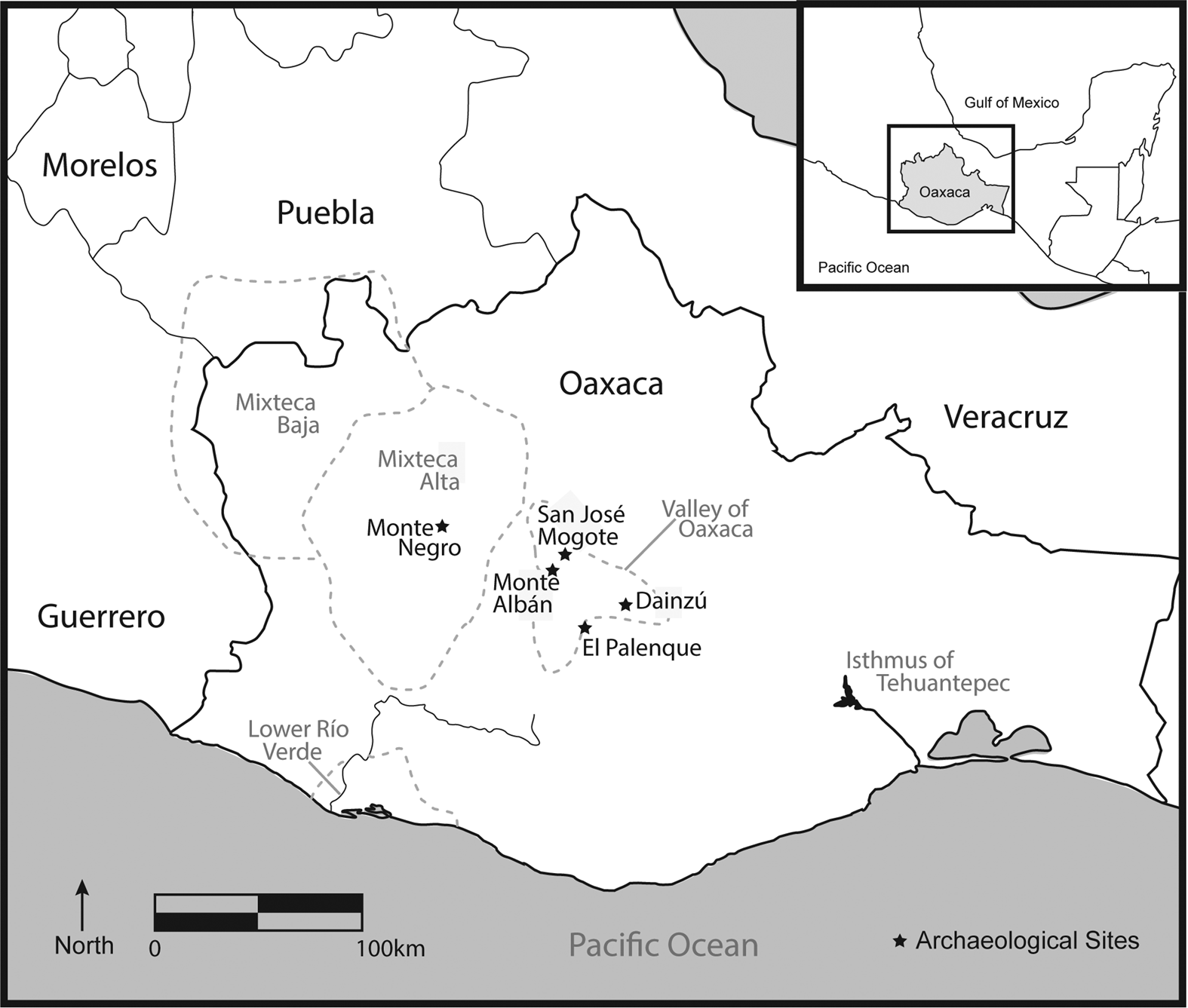
Figure 1. Map of Oaxaca.
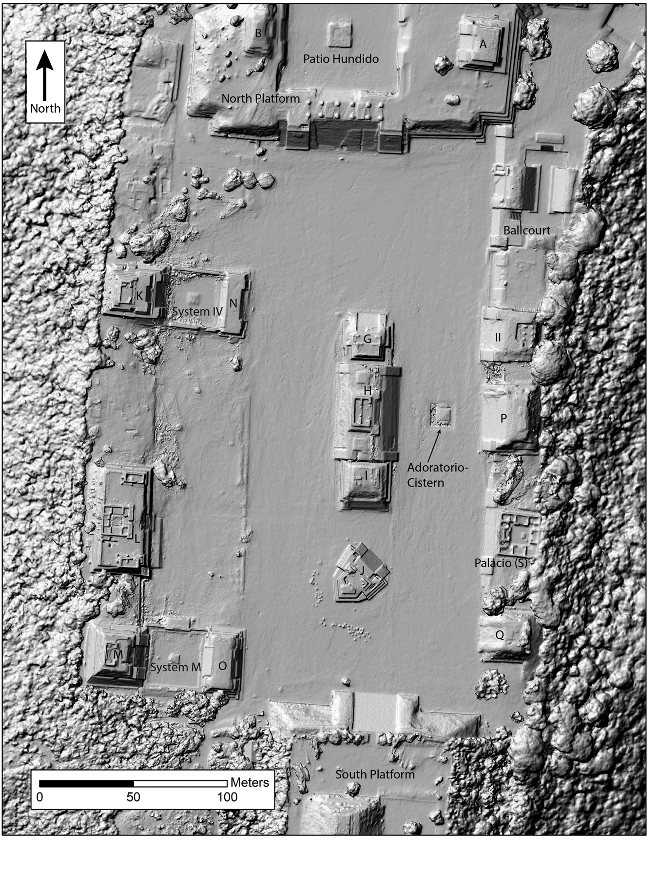
Figure 2. Hillshade map of Monte Albán's Main Plaza based on photogrammetric data collected by UAV.
This article presents the results of the Proyecto Geofísico de Monte Albán (PGMA), a project that used geophysical prospection and digital mapping techniques to carry out a systematic analysis of Monte Albán's Main Plaza. Here, we focus on the results of the geophysical survey, which included ground-penetrating radar, electrical resistance, and gradiometry. This work sought to identify subsurface features corresponding to earlier iterations of the Main Plaza and thereby shed light on the capital's early history.
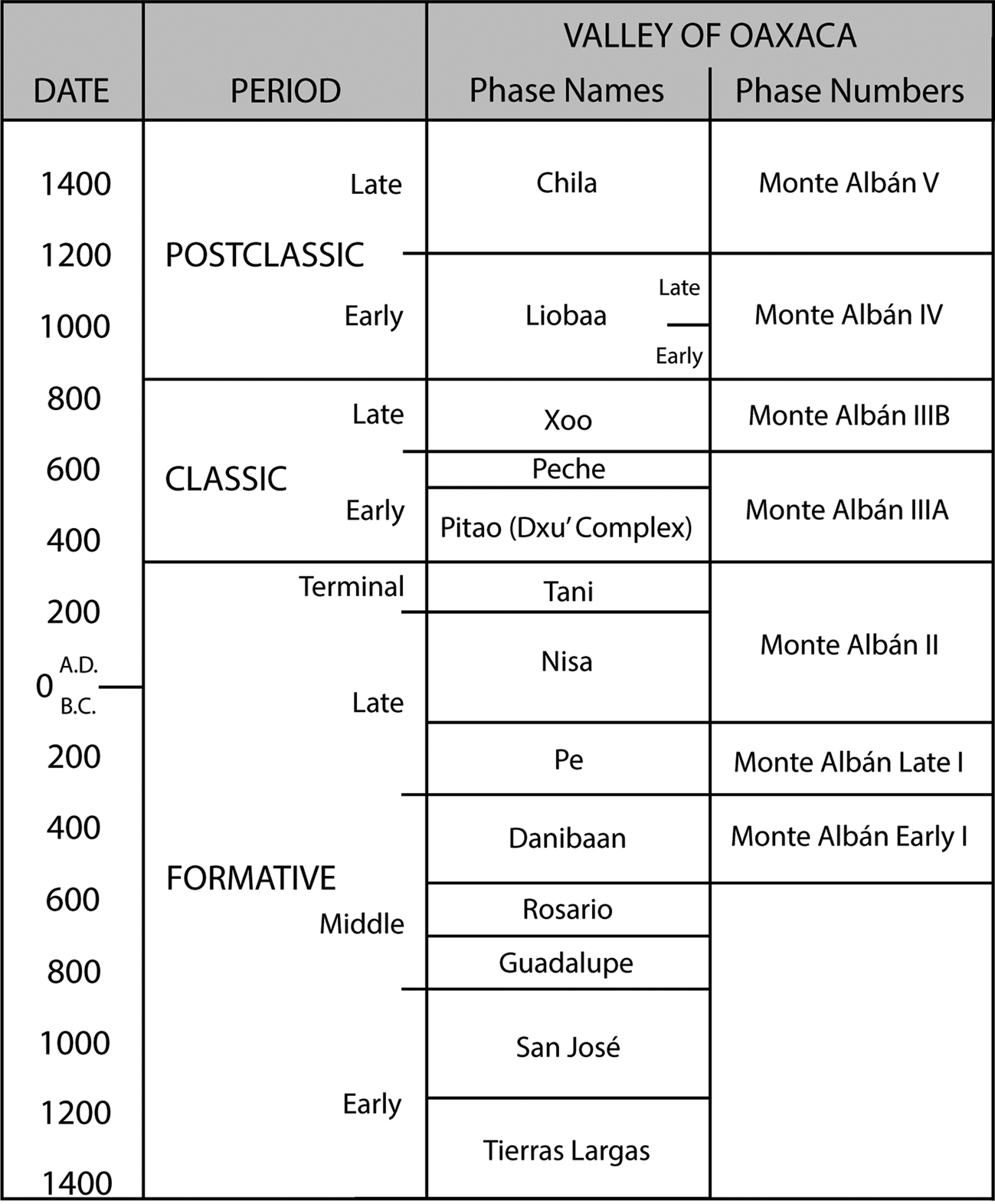
The PGMA results demonstrate the presence of at least three previously unidentified prehispanic structures that lie below the Main Plaza surface. We argue that all three date before or during the early Nisa phase (100 BC–AD 200) and represent the remnants of a Late Formative Main Plaza that was significantly different from the one we see today (Figure 3). Furthermore, we argue that all three structures were intentionally destroyed and buried during the Pe (300–100 BC) to Nisa (Late Period I to Period II) phase transition and before a major renovation of the Main Plaza in the Nisa phase. Among these structures are the remains of a moderately sized building (18 × 18 m) that we argue was a temple. We interpret the geophysical data in light of evidence from previous work at Monte Albán to argue that the Pe-to-Nisa phase transition was a tumultuous period of significant political, social, and cultural transformation. Most scholars have not fully addressed this pivotal shift in Monte Albán's early history, one that left its mark on the Main Plaza and ultimately ushered in an unprecedented period of prosperity.

Figure 3. Valley of Oaxaca ceramic chronology. Two systems remain in use, one using phase numbers (Kowalewski et al. Reference Kowalewski, Feinman, Finsten, Blanton and Nicholas1989:Table 1.1) and a recently revised chronology with phase names (Winter Reference Winter2011:Figure 3).
Monte Albán's Main Plaza
Researchers working in Mesoamerica are now using a variety of approaches to examine plazas as active and dynamic spaces that structured social, economic, and ritual activities (Tsukamoto and Inomata Reference Tsukamoto and Inomata2014). These approaches include studies of form and layout, labor investment, space syntax, phenomenology, soil chemistry, view-shed analysis, and life-history approaches (see chapters in Tsukamoto and Inomata Reference Tsukamoto and Inomata2014). Geophysical prospection techniques remain underused in Mesoamerica, although this has begun to change recently (e.g., Barba Reference Barba and Manzanilla1993; Blancas et al. Reference Blancas, Luis Barba and Carballo2015; López-Rodríguez et al. Reference López-Rodríguez, Velasco-Herrera, Álvarez-Béjar, Gómez-Chávez and Gazzola2016; Skaggs et al. Reference Skaggs, Powis, Rucker and Micheletti2016; Venter et al. Reference Venter, Thompson, Reynolds and Waggoner2006).
Before the PGMA began its work, only very limited geophysical prospection had been carried out at Monte Albán. Gonzalez Licón (Reference González Licón2011) used ground-penetrating radar (GPR) during residential excavations; Robles García (Reference Robles García2009b) also used GPR for conservation assessments of structures following a powerful earthquake in 1999. Using three techniques and covering the entire Main Plaza, the PGMA is the largest and most comprehensive geophysical project ever carried out at Monte Albán and in the state of Oaxaca. As far as we know, it is also the first project to use gradiometry and electrical resistance at the site.
Continuing research on the Main Plaza remains vital because there are so many unresolved questions about its initial construction, development, function, and meaning. In particular, we know relatively little about its form, scale, and orientation in the first centuries following its establishment around 500 BC. The scarcity of data regarding the Main Plaza during the Danibaan (500–300 BC) and Pe (300–100 BC) phases has severely curtailed our ability to evaluate rival models attempting to explain Monte Albán's early history.
Caso and colleagues carried out extensive research on the Main Plaza, but this work was largely mound-centric and focused less on the plaza itself. Writing of Period I architecture, Acosta (Reference Acosta and Willey1965:814) notes, “There are few architectural remains. Many of the buildings were destroyed; others are still buried at great depths or covered by series of later buildings.” Subsequent researchers understandably accepted the notion that all Period I (Danibaan and Pe phase) buildings on the Main Plaza were buried beneath later construction and thus were difficult to access for research (Blanton et al. Reference Blanton, Feinman, Kowalewski and Nicholas1999:53; Marcus and Flannery Reference Marcus and Flannery1996:165, 178; Redmond and Spencer Reference Redmond and Spencer2008:239, 257). Yet we observed that no systematic study had been carried out of the Main Plaza itself. Could there be any early structures or other important features that remain undiscovered in shallow deposits beneath open areas of the plaza? If so, what could these features reveal about previous iterations of the Main Plaza? We decided that geophysical prospection would be an effective means to investigate these questions, given that these techniques allow for extensive studies across broad areas where excavation would be logistically difficult. In the following sections, we describe our geophysical methodology and present the most significant results, including the discovery of three buried structures.
Methodology and Fieldwork
Geophysical prospection presents a number of advantages for examining large spaces like Monte Albán's Main Plaza, which we estimate covered an area of 45,424 m2. These techniques can be deployed across broad expanses in a relatively short period of time, are well equipped to reveal large-scale subsurface features, and are completely nondestructive.
The main goal of the geophysical survey was to locate subsurface “anomalies” representing archaeological features, such as buried structures, tunnels, stone monuments, and water-management features. Studies of buried features can contribute to our understanding of how the Main Plaza was built, used, and remodeled through time. The PGMA used ground-penetrating radar, electrical resistance, and gradiometry to detect subsurface anomalies below the surface of the Main Plaza. By combining three complementary techniques, we sought to maximize our potential for success.
Ground-Penetrating Radar
Ground-penetrating radar (GPR) is an active technology, meaning it introduces an artificial field to measure response. GPR works by sending pulses of radar into the ground, which are reflected, absorbed, or otherwise deflected by buried features. The return time of these pulses indicates the depth of the anomaly.
Soil properties and the frequency of the GPR antenna determine both the depth that the radar pulse will penetrate and its resolution. Higher frequencies will not go particularly deep but can detect smaller objects. Lower frequencies will go deeper and can detect larger objects (Conyers Reference Conyers2004). The speed of the pulse depends on both the composition and moisture content of the soil through which the signal travels. The PGMA used both high (400 MHz) and low (200 MHz) frequency antennas. Hyperbola-shaped anomalies often appear directly over archaeological features.
A GSSI SIR-3000 with a 400 MHz antenna mounted on a three-wheeled cart was used for most of the GPR survey on the Main Plaza. The cart was moved in a zigzag pattern across the survey area, and the antenna remained on the ground surface during data collection. Data were collected at 100 readings per meter with 0.5 m spacing between transects. Signal strength was good to a depth of roughly 2 m. We also used a 200 MHz antenna in areas where we wanted to penetrate more deeply below the plaza surface.
Electrical Resistance
Electrical resistance measures the resistance of soils and other materials to the conduction of an electrical current. Subsurface features have different physical properties and therefore have variable levels of resistance to the flow of electricity. Compaction, porosity, and moisture retention affect the electrical current in different ways. The electrical resistance meter is placed on a specialized rack with a set of steel probes that are inserted into the ground for each measurement. The instrument measures the amount of resistance to the flow of this current as it completes its circuit (Gaffney and Gater Reference Gaffney and Gater2003). The PGMA used a Geoscan Research RM-15 with an MPX15 multiplexer in a PA20 multi-probe array, which can detect anomalies to a depth of approximately 1 m.
The amount of moisture in the soil can have a significant effect on survey results. Because water is highly conductive, electricity flows through it with decreased resistance. Therefore, heavy rain or the presence of localized areas where water collects can cause low resistance readings. Daily rainfall during the PGMA fieldwork kept soils from becoming overly dry and proved to be beneficial.
Gradiometry
A gradiometer is a passive sensor that measures changes in magnetic fields in a unit known as nanoteslas (nT; Aspinall et al. Reference Aspinall, Gaffney and Schmidt2008; Clark Reference Clark1996). Burning and disturbance both alter the magnetic reading of soil, meaning features such as fire pits, mounds, old excavation units, burials, and house floors are typically detectable using this technology. Soils with high organic content also have slightly higher magnetic readings (Lockhart Reference Lockhart2010). Metal objects have very high readings and are visible as dipoles (a strong alternate high and low nT reading), which can pose a problem for gradiometer survey. The PGMA used a Bartington Grad 601 gradiometer.
At Monte Albán, we encountered metal interference from rebar used by previous excavation and reconstruction efforts and from metal poles, chains, signs, and litter (e.g., bottle caps). We effectively managed this interference through avoidance during the survey and data processing.
Fieldwork
The PGMA fieldwork (June 15–July 14, 2017) was carried out during the rainy season, and light rain was common in the late afternoons. The elevated moisture of subsurface sediments seems to have improved the quality of the electrical resistance survey because dry sediments generally present a challenge for this technique. Monte Albán's hilltop setting includes a range of sedimentary rocks, such as sandstone, limestone, and conglomerates.
Before we did the geophysical prospection, we established a grid over the surface of the Main Plaza with the aid of a robotic total station. The grid consisted of 20 × 20 m squares that served as a means of horizontal control and were the basic unit of analysis. Our coverage of the plaza was not quite 100% because we had to skip areas with physical obstacles (e.g., trees, fences) or other types of interference (Table 1).
Table 1. Geophysical Survey Coverage of the Main Plaza.

Note: Total area of Main Plaza estimated at 45,424 m2.
Results
Our discussion of the PGMA results focuses on three of the most distinctive anomalies discovered, all of which are identified as buried prehispanic structures (Levine Reference Levine2020). We begin with the evidence for Structure H4-1 and associated features, located on the western side of the plaza and just west of Building H (Figures 4–7). Based on the geophysical evidence and a comparative study of structures at Monte Albán and elsewhere in Oaxaca, we then argue that Str. H4-1 probably represents the remains of a Late Formative temple platform (Figure 7). In addition, we discuss the evidence for two smaller structures, dubbed F8-1 and H8-1, which are located on the east side of the Main Plaza. Although the evidence demonstrates that these were structures, their precise function remains undetermined. Finally, we present evidence supporting the idea that all three structures were once part of a cohesive architectural complex that was intentionally buried below the Nisa-phase plaza that we see today.

Figure 4. Gradiometer results from Main Plaza (labels correspond to structures that are masked).

Figure 5. Geophysical prospection results with Str. H4-1 and associated features: (a) gradiometry; (b) electrical resistance; and (c) ground-penetrating radar with (d) corresponding GPR profile.
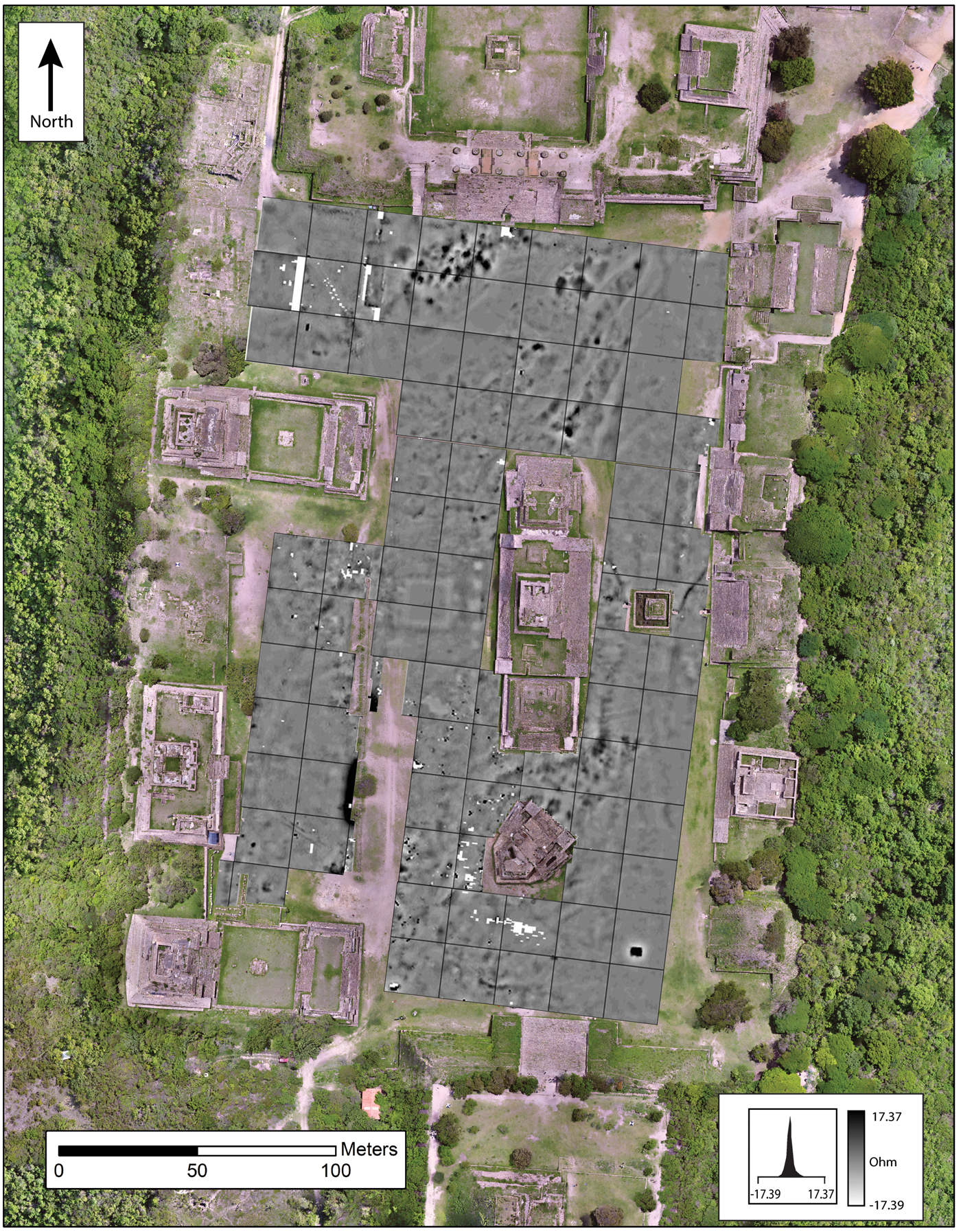
Figure 6. Electrical resistance results superimposed over orthophoto of Main Plaza. (Color online)
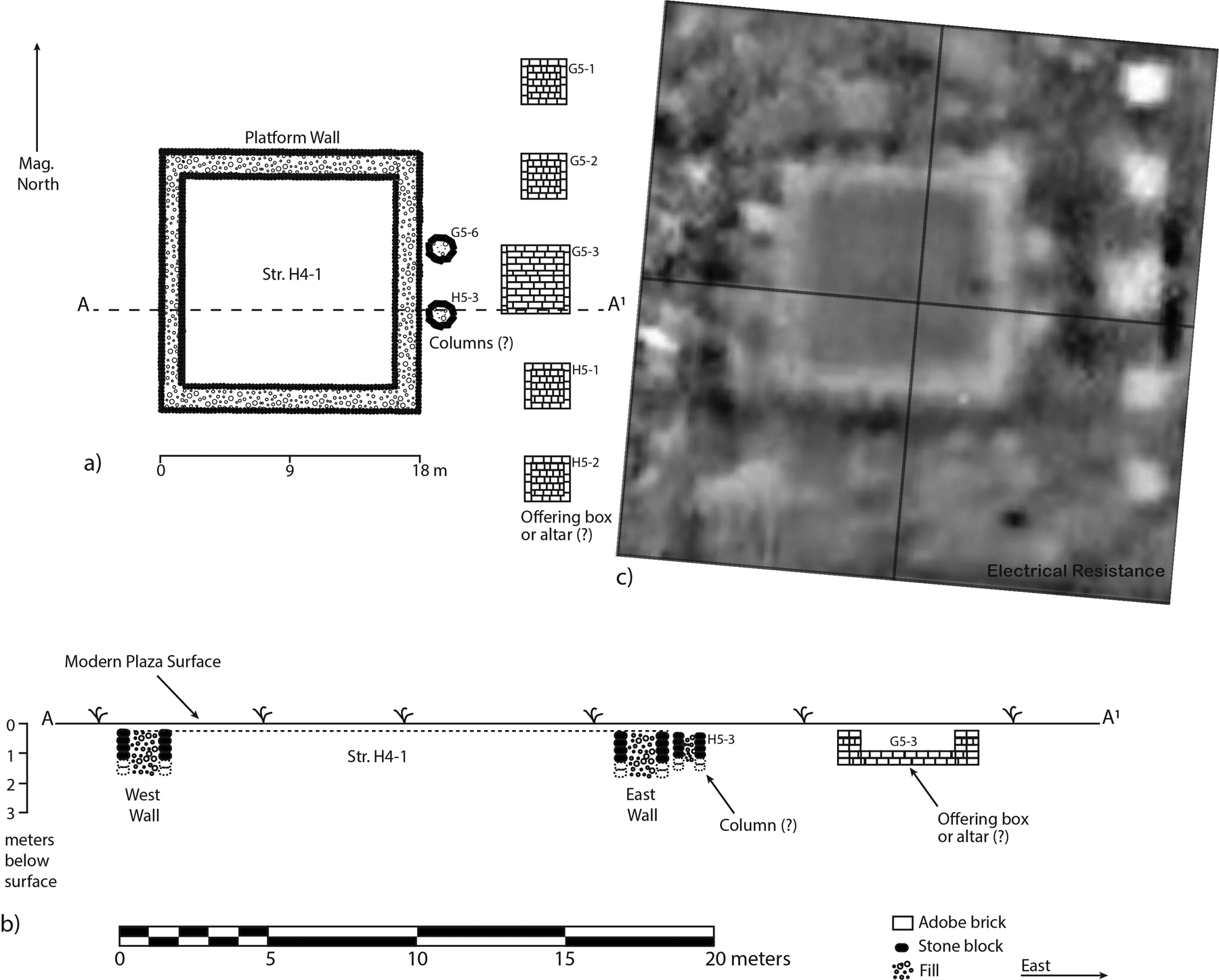
Figure 7. Hypothetical reconstruction of Str. H4-1: (a) plan view; (b) profile view; and (c) corresponding electrical resistance data.
Structure H4-1: Gradiometer Results
The gradiometer registered Str. H4-1 as two concentric squares marked by low magnetism and a narrow band between these squares exhibiting higher magnetism (Figures 4 and 5). This may suggest the presence of a “core-and-veneer” type wall, comprised by interior and exterior stone walls with a sediment-filled core. The higher magnetic readings could represent the core-fill, including sediment mixed with burned material. The considerable girth of the walls, measuring 1.5–2.0 m thick, indicates they were designed to buttress a considerable amount of weight. These data are consistent with the interpretation that Str. H4-1 represents a platform.
The darker square area within the walls marks the occupational surface of the platform, which would have also served as the floor of any superstructure that it supported. Str. H4-1 has a single room with no evidence for interior walls or partitions. In the interior, the gradiometer revealed at least six semicircular anomalies (<1 m diameter each), with many located along interior walls (Figure 5). Their relatively high magnetic signatures suggest they could be refilled pits, offerings, or burials. These smaller anomalies also recall the ashy areas associated with habitual incense burning reported from a temple (Str. 35) at San José Mogote (Marcus and Flannery Reference Marcus and Flannery1996:185). Alternatively, the six anomalies could represent heterogeneous pockets of fill from beneath the platform's floor surface.
Extending east of Str. H4-1 and toward Building H (Figure 5), the gradiometer detected a dark linear anomaly (G5-4) measuring approximately 10 m in length. This also appeared in the GPR readings, though it was less clearly defined. Although it was difficult to interpret, we suggest that this linear anomaly could represent the remains of a passageway or collapsed tunnel, such as those associated with the Adoratorio-Cistern, located on the east side of the Main Plaza (Acosta Reference Acosta1974:72).Footnote 1 Alternatively, anomaly G5-4 could mark the remains of a prehispanic trench used for water drainage.
Structure H4-1: Electrical Resistance Results
The electrical resistance survey confirms the presence of Str. H4-1, revealing thick exterior walls of low resistance ringed by more diffuse areas of slightly higher resistance (Figure 5). Given the gradiometer results, which suggest that Str. H4-1 had core-and-veneer walls, the low resistance readings may mark the wall's core-fill, where moisture is likely trapped. In general, wet sediments are less resistant to an electrical current than dry sediments or denser materials, such as stone. The darker, high-resistance areas around the perimeter of Str. H4-1 could represent accumulations of denser eroded building material. The interior of Str. H4-1 appears as a homogeneous square of high resistance. An exception is a small dark anomaly along the centerline of the interior eastern wall that could represent a subfloor pit.
The resistance survey also detected two circular anomalies (H5-3, G5-6) measuring approximately 2–3 m in diameter located on the exterior of the eastern wall of Str. H4-1 (Figure 5). These symmetrically placed anomalies are consistent with the size, shape, and position of columns reported from temples at Monte Albán (see Martínez López Reference Martínez López, de la Cruz and Winter2002). The circular anomalies were also detected by GPR but were notably absent in the gradiometer survey. Temples at Monte Albán exhibit columns made from a diversity of materials, including stone slabs, stacks of stone cylinders, or combinations of stone, adobe, and earthen fill (Fahmel Reference Fahmel Beyer1991:105, 146, 177, 181, 191; Winter Reference Winter and Winter1994:Figure 14). Yet these circular anomalies are probably not entirely stone, given their low resistance readings. Instead, they may be columns made from adobe blocks with a sediment-filled core, which probably retains water after rain (c.f., Spores Reference Spores, Flannery and Marcus2015:325–329). Excavations of Str. 36 at San José Mogote, a Period II temple with columns, present another possible interpretation. Flannery and Marcus (Reference Flannery and Marcus2015:233–242) describe a temple with columns made from cypress tree trunks (70–80 cm in diameter) that had footings lined with clay plaster and ringed by stone blocks. We suspect that shallow basin-like column footings of this type would trap moisture and therefore ought to be detected by electrical resistance. This suggests an alternative interpretation for H5-3 and G5-6 as column footings. Future studies of variability in column construction materials and form may reveal important cultural or chronological information.
If anomalies H5-3 and G5-6, in fact, represent columns, their location must index the structure's entrance, as is the case with all columned buildings at Monte Albán. Importantly, this further indicates that the main entrance of Str. H4-1 faced east. As discussed later, the presence of columns is essential to our argument that Str. H4-1 was a temple platform. All buildings with columns at Monte Albán are identified as temples.Footnote 2
Approximately 5 m east of Str. H4-1, the electrical resistance survey detected five square-shaped anomalies marking areas of low resistance (Figures 5 and 6). Four of these squares measure 4 × 4 m, whereas the fifth and central square was slightly larger at 6 × 6 m. The squares are aligned to one another, evenly spaced, and share the same orientation as Str. H4-1. These characteristics, along with the squares’ proximity to Str. H4-1, suggest their close relationship. Somewhat puzzlingly, only one of the squares was detected by GPR, and none appeared in the gradiometer results. Although the squares are similar in size and shape to stone altars known from Monte Albán, our data suggest they were not made entirely from stone.
The five square anomalies bear a general resemblance to the subterranean stone “offering boxes” or cists with dedicatory offerings discovered at the northeast and northwest corners of the South Platform (Acosta Reference Acosta1958: Figures 12, 19, 27). Yet these anomalies, marked by low resistance, do not appear to be stone. Interestingly, at San José Mogote, Flannery and Marcus (Reference Flannery and Marcus2015:259–271, 293–296) report similarly sized offering boxes made from adobe blocks. We suspect that adobe cists, made from sediments similar to the surrounding fill, could trap moisture and show up in the resistance data, while evading detection via gradiometry or GPR. If the five anomalies are indeed cists, they may contain offerings associated with Str. H4-1.
On the exterior side of Str. H4-1's western wall, the electrical resistance registered a jumble of rather indistinct anomalies marked by low resistance. These may represent collapsed building material or the remains of a more formal feature, such as a stairway.
Structure H4-1: GPR Results
The GPR data further confirm the presence and form of Str. H4-1, delineating two concentric squares representing interior and exterior walls (Figure 5). Yet GPR also shows that Str. H4-1 lies only 15–20 cm below the current plaza surface. Using the 400 MHz antenna, we traced the structure's walls to a depth of 95 cm below the surface. When we used the 200 MHz antenna, which penetrates more deeply, we found that the structure extends to at least 120 cm. Intriguingly, this indicates that Str. H4-1 was erected on an earlier occupational surface lying more than 1 m below the current plaza.
As already mentioned, the GPR results confirm the presence of the two circular anomalies identified by gradiometry and interpreted as columns. Within Str. H4-1, the GPR detected a series of small and amorphous anomalies that may represent subfloor features but could also represent heterogeneous deposits within the platform fill.
Chronology and Function of Str H4-1
Synthesizing the geophysical results reveals a relatively detailed picture of Str. H4-1 as a moderately sized square structure (18 × 18 m) rising to more than a meter in height (Figure 7). It had heavy exterior walls, measuring 1.5–2.0 m thick. No internal walls were found, but several small anomalies may represent features associated with the floor. Lastly, two columns on the structure's east side probably mark its main entrance.
Str. H4-1 is aligned to magnetic north (3°–4° east of astronomical north), which is in keeping with other structures at the capital. Blanton (Reference Blanton1978:45) reports that most (63%) mound groups associated with Late I and II (Pe and Nisa phase) pottery were oriented within a range of 2°–3° east or west of magnetic north. Similarly, most structures on the Main Plaza hover within a few degrees of magnetic north.
In terms of chronology, available evidence suggests that Str. H4-1 was built, occupied, and destroyed between the beginning of the Danibaan phase and the end of the Nisa phase. This is based on the stratigraphic position of Str. H4-1 and insights from previous excavations. First, we assume that Str. H4-1 postdates Monte Albán's founding at approximately 500 BC. Second, Str. H4-1 must have been occupied before the end of the Nisa phase, because it was found beneath the current plaza surface, which itself was built to its current height during the Nisa phase or Period II (Acosta Reference Acosta and Willey1965:818; Flannery Reference Flannery, Flannery and Marcus1983:102–103).
In terms of function, Str. H4-1's location in the heart of the Main Plaza suggests it was a public building and was integral to civic-ceremonial life. A comparative study of its architectural attributes in relation to structures from Monte Albán and farther afield provides additional insights. Considering its size and shape, we find it unlikely that Str. H4-1 was a residence, palace, ballcourt, or altar. Instead, Str. H4-1 shares much in common with structures identified as temples or temple platforms (Table 2). The presence of columns, a diagnostic feature of temples at Monte Albán, also strongly suggests Str. H4-1 was a temple. We next discuss architectural comparisons between Str. H4-1 and other Formative Period temples in Oaxaca.
Table 2. Temples Reported from Middle to Late Formative Sites in Oaxaca.

a We focus on the general direction that a building faced, but where available, we also provide orientation in relation to magnetic north.
b Previous maps of the Main Plaza were oriented toward magnetic north (e.g., Blanton Reference Blanton1978) but also aligned to astronomical north (Peeler Reference Peeler1994), and this is a potential source of confusion for comparative studies. Structures on the Main Plaza exhibit moderate differences in orientation, ranging from 2° to 6° east or west of magnetic north (Blanton Reference Blanton1978:Table 3.1).
c Estimated from published maps.
Among the few known Period I temples from Monte Albán, Temple K-sub is the best documented (Acosta Reference Acosta1975:2–3; Fahmel Reference Fahmel Beyer1991:107–112). Found beneath Building K on the west side of the Main Plaza, Temple K-sub resembles Str. H4-1 in that it also has a single room and two columns (Martínez López Reference Martínez López, de la Cruz and Winter2002:242, Figure 21). Yet K-sub differs in that it faces north and does not have thick exterior walls. Broadening our comparisons, we find that Str. H4-1 has even more in common with Str. 19B, a temple platform from San José Mogote in the Etla Valley (Flannery and Marcus Reference Flannery and Marcus2015:119–127). Built atop Mound 1 in the Rosario phase (700–500 BC), Str. 19B supported Str. 28, a wattle-and-daub temple that was burned a short time after 600 BC (Flannery and Marcus Reference Flannery and Marcus2015:147–164).Footnote 3 Structures H4-1 and 19B are nearly identical in size and shape, and both face east and have a single room. Yet Str. 19B does not have columns or the thick walls characteristic of Str. H4-1.
Comparisons with Period I ritual structures at El Palenque, located in the Valle Grande near the modern town of San Martín Tilcajete, are also helpful (Redmond and Spencer Reference Redmond and Spencer2008; Reference Redmond and Spencer2013). Three Late Period I temples (Str. 16, 20, 29) reported from El Palenque have thick walls like Str. H4-1 but differ in form (elongated rectangular) and have multiple rooms. Notably, Str. 20 has four columns, but they are square, rather than what appear to be circular examples associated with Str. H4-1. Turning to the site of Dainzú in the Tlacolula Valley, the Period I “Templo Amarillo” has two columns resembling those of Str. H4-1, but this structure is far smaller and rectangular, and it faces west (Bernal and Oliveros Reference Bernal and Oliveros1988:9, Foto 3, Lámina 9).
In the Mixteca Alta, northwest of the Valley of Oaxaca, Period I temples from Monte Negro share characteristics with Str. H4-1 (Acosta and Romero Reference Acosta and Romero1992:32–43). Most relevant are comparisons to Temples TS and TN, which are similar in size and shape to Str. H4-1. The Monte Negro temples also have columns, yet they appear in greater quantities (6–10) and are in different arrangements. Rectangular tombs, made primarily from adobes, were also discovered beneath both temples.
Considering comparative data from the Nisa phase, the temple atop Mound X at Monte Albán is the best-preserved available structure (Acosta Reference Acosta1974:72–79). This square-shaped temple had two rooms and a total of four stone-masonry columns flanking the interior and exterior entryways. It was clearly smaller than Str. H4-1 and also faced south, instead of east. Yet this southward orientation was the exception for Nisa-phase temples at Monte Albán, most of which faced east, including those atop Buildings H, K, L, and M. This eastward orientation probably reflects a concern with solar observation and tracking the sunrise on the eastern horizon throughout the year (Peeler and Winter Reference Peeler and Winter1992–1993:40). Interestingly, Urcid (Reference Urcid, Jennings and Sellen2018:50) notes that the east-facing two-room temple located in the Vertíce Geodésico complex on the North Platform has two stone columns bearing glyphs associated with the sun. In Oaxaca and across Mesoamerica, astronomers closely followed the sun's movements to better coordinate vital agricultural activities (Šprajc Reference Šprajc2018).
A Nisa-phase temple platform from San José Mogote, dubbed Str. 14, is remarkably similar to Str. H4-1 in terms of shape and size (Table 2). This platform supported a temple (Str. 36) that differed, however, in that it had two rooms and four columns, and it faced west. Also notable is the fact that several subterranean offering boxes were found near Str. 36 and Str. 35, consecutive temples built on the same spot (Flannery and Marcus Reference Flannery and Marcus2015:266). As already discussed, we suggest the five square anomalies found east of Str. H4-1 could represent similar offerings.
In sum, these comparisons demonstrate that Str. H4-1 exhibits a mosaic of attributes reported from both Period I (Danibaan and Pe phases) and Period II (Nisa phase) temple platforms from Monte Albán and elsewhere. For instance, Str. H4-1 is very similar in size and shape to Str. 19B from San José Mogote but has thicker walls like temples from El Palenque. Furthermore, Str. H4-1 has circular columns that most resemble those from Period I temples at Monte Negro or Period II temples at San José Mogote. The fact that Str. H4-1 had a single room could suggest an earlier date (Danibaan or Pe phase), but single-room temples were also present during the Nisa phase, although less common than two-room varieties.
We conclude that Str. H4-1 represents one or more consecutive temple platforms from the Danibaan, Pe, or Nisa phases (Period I or Period II). It would not be surprising if it had been occupied for a few centuries, given the Zapotec's penchant for building and rebuilding temples on the same hallowed ground (Marcus and Flannery Reference Marcus and Flannery2004:18260). Overall, the foregoing comparisons strongly support the argument that Str. H4-1 was a temple platform, although more intensive research will be required to confirm its function and chronology.
Structures F8-1 and H8-1
On the east side of the Main Plaza, between Buildings H and P, we detected two additional anomalies: F8-1 and H8-1 (Figure 8). Both were square, relatively small (8 × 8 m), and located in symmetrical positions approximately 5 m north and south of the Adoratorio-Cistern. In this section, we discuss the geophysical evidence and argue that F8-1 and H8-1 were structures, but their function remains undetermined. We further argue that they were probably contemporaneous with one another and with Str. H4-1, based on stratigraphic and spatial associations.

Figure 8. Structures F8-1 and H8-1 in relation to the Adoratorio-Cistern: (a) line drawing; (b) electrical resistance data; and (c) gradiometer data.
The gradiometer results reveal that anomaly F8-1 was a small square (8 × 8 m) marked by higher magnetic strength in comparison to surrounding areas. Several small (<1 m) anomalies within the square could represent burned areas but remain poorly understood. Unfortunately, the gradiometer survey was hobbled by the presence of buried metal located east, west, and south of the Adoratorio-Cistern. Dating to the historic or modern era, this metal appears as distinct white-and-black “dipoles” that obscure any features that might have otherwise been detected. Because of this interference, the gradiometer did not detect anomaly H8-1.
Confirming the gradiometer results, the electrical resistance yielded a sharper image of Str. F8-1. The structure's outline appears as a line of low resistance, whereas the interior exhibits slightly higher resistance. Similar to Str. H4-1, this may indicate that Str. F8-1 had core-and-veneer walls that now retain seasonal rainwater and thus aided detection. Str. F8-1 also appears to share the same orientation as Str. H4-1, aligned toward magnetic north. No interior walls were found within Str. F8-1, but slightly higher resistance readings in its interior could represent a prepared floor. In the structure's southwest corner, a small amorphous anomaly with higher resistance could be a pit feature. The GPR (400 MHz antenna) also detected Str. F8-1 and reveals that it lies only 25 cm below the plaza surface.
Approximately 5 m south of the Adoratorio-Cistern, the electrical resistance survey detected Str. H8-1, which shared the same shape, size, and orientation as Str. F8-1. Yet the resistance image of Str. H8-1 was more diffuse than that of Str. F8-1, due to unspecified disturbance in this area. Fortunately, Str. H8-1 did appear clearly in the GPR data, indicating it was buried at a depth similar to that of Str. F8-1 (Figure 9).

Figure 9. Ground-penetrating radar data with remains of Str. H8-1: (a) profile view and (b) plan view.
Chronology and Function of Strs. F8-1 and H8-1
Given their small size (8 × 8 m), we can rule out the possibility that Structures F8-1 and H8-1 represent larger constructions, such as temple platforms, palaces, or ballcourts. Instead, their size and shape invite comparison to stone altars found in the North Platform's Patio Hundido (12 × 12 m), and smaller examples from the patios of Systems M (5.7 × 5.0 m) and IV (5.8 × 5.8 m). Yet although these altars are entirely made from stone, Structures F8-1 and H8-1 only appear to have had stone exterior walls. An alternative interpretation is that they were water-storage features, similar to the early phase of the Adoratorio-Cistern (Acosta Reference Acosta1949; Urcid Reference Urcid, Jennings and Sellen2018:52). The cistern, which lies below and predates a series of stone altars (“adoratorios”), resembles Structures F8-1 and H8-1 but is slightly larger (ranging from 13.3 × 13.3 m to 15.5 × 15.5 m). Though clearly structures, the functions of F8-1 and H8-1 remain elusive.
In terms of chronology, we reason that, because Structures F8-1 and H8-1 lie 25 cm below the plaza surface, they must date to either the Danibaan, Pe, or Nisa phases. Like Str. H4-1, they were deliberately buried when the plaza surface was elevated and refinished during the Nisa phase (Acosta Reference Acosta and Willey1965:818). Strs. F8-1 and H8-1 were probably contemporaneous, based on their formal similarity, shared orientation, stratigraphic position, and symmetrical placement north and south of the Adoratorio-Cistern. By extension, we propose they were contemporaneous with Str. H4-1, given that all three structures were found at a similar depth below the plaza and share the same orientation (Figure 10). If the foregoing is correct, we further speculate that these features represent the remnants of a buried architectural complex that once spanned the areas east and west of Building H. We refer to this hypothetical architectural unit as the “PGMA complex.”
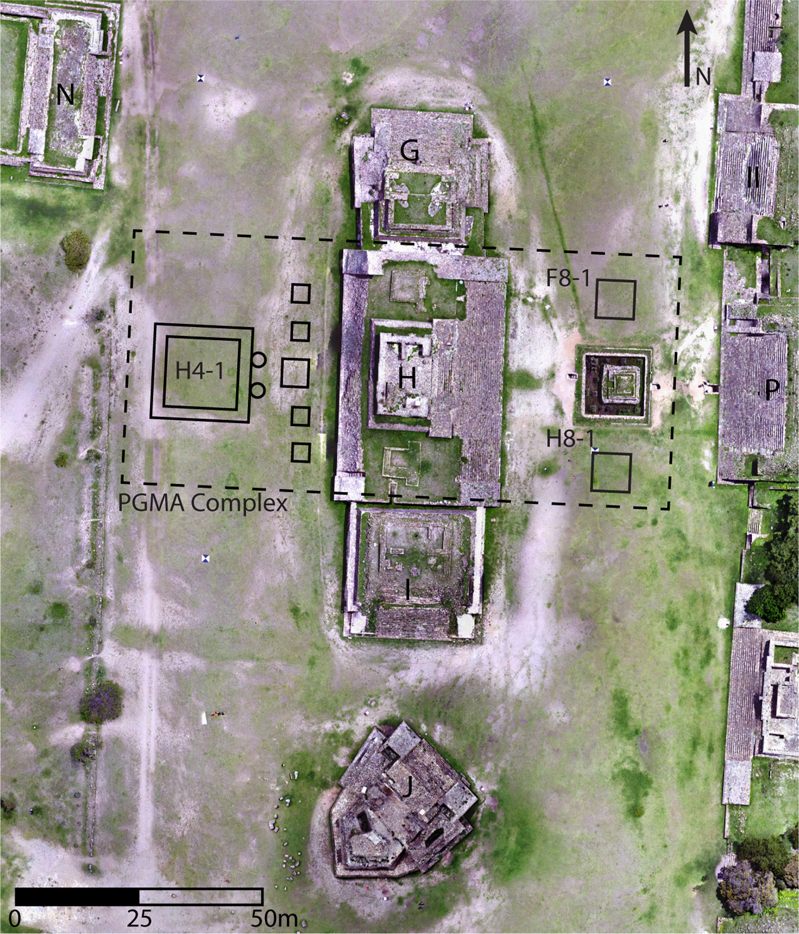
Figure 10. Hypothetical location of “PGMA complex” within central area of Main Plaza. (Color online)
The proposed PGMA complex may have included additional structures beneath neighboring constructions that have yet to be discovered. The neighboring Adoratorio-Cistern is often cited as a Nisa-phase construction (Acosta Reference Acosta1949), but we argue that it was initially built earlier and may have been part of the PGMA complex. Stratigraphic evidence demonstrates that at least one earlier cistern, which has yet to be dated, lies beneath the Nisa-phase cistern. Like the geophysically detected structures, the Adoratorio-Cistern and associated tunnels were buried during a large-scale renovation of the Main Plaza in the Nisa phase. Interestingly, an altar or adoratorio was erected just above the cistern, perhaps as an act of commemoration.
A consideration of spatial relationships also suggests the Adoratorio-Cistern may have been part of the proposed PGMA complex. Viewed from overhead, Structures F8-1 and H8-1 are placed symmetrically and equidistant from the Adoratorio-Cistern (Figure 10). In addition, Str. H4-1 and the Adoratorio-Cistern lie in symmetrical positions on their respective western and eastern sides of the Main Plaza. The shared symmetry and orientations of the aforementioned structures suggest they were part of a singular architectural plan. We may even speculate further that religious practices conducted at the Str. H4-1 temple may have incorporated water-related rituals at the Adoratorio-Cistern. Surely a valuable commodity at Monte Albán, water was an active and transformative component of ritual and public ceremony throughout Mesoamerica (Joyce Reference Joyce, Alt and Pauketat2019; Lucero and Fash Reference Lucero and Fash2006). We also note that Structure H4-1 met the same fate of the Adoratorio-Cistern when it was deliberately buried to make way for the higher plaza surface in the Nisa phase. Yet for some reason, Str. H4-1 was not commemorated with altars in the same manner as the Adoratorio-Cistern—a point we return to later.
Assuming our identification of the PGMA complex is valid, we further observe that the associated structures generally trend from east to west. If correct, this evidence tempers the widespread assumption that the Main Plaza has, throughout its history, exhibited a prevailing north–south orientation (e.g., Blanton Reference Blanton1978:45). Pool (Reference Pool, Arnold and Pool2008:134) notes that buildings from Groups 1 and 2 at Tres Zapotes, like many architectural complexes at roughly contemporaneous Maya sites, emphasize an east–west axis oriented with the path of the sun (see Milbrath Reference Milbrath2017). This finding also has implications for the idea that at certain times during its history, the Main Plaza may have been conceived as a cosmogram (Joyce Reference Joyce, Dobres and Robb2000).
Reconfiguring the Main Plaza and Political Transformation
Our geophysical survey and architectural analysis indicate that prior to the end of the Nisa phase (Period II), Monte Albán's leaders intentionally destroyed and buried a temple platform and at least two other structures at the site's center. We argue that these events were part of a tumultuous transformation that shook Monte Albán during the Pe-to-Nisa phase transition. Some researchers have argued that dramatic and perhaps violent sociopolitical change occurred at the end of the Pe phase (see Blanton Reference Blanton1978:54–55; Blanton et al. Reference Blanton, Feinman, Kowalewski and Nicholas1999:110; Flannery and Marcus Reference Flannery and Marcus2015:219; Joyce Reference Joyce2010:159). We suggest, however, that the significance of this crisis in Monte Albán's history has not been fully appreciated (e.g., Marcus and Flannery Reference Marcus and Flannery1996:172).
Urcid and Joyce (Reference Urcid, Joyce, Tsukamoto and Inomata2014) have reassessed archaeological evidence from Monte Albán and argued that the capital witnessed a radical transformation at the close of the Pe phase. This argument relies in part on reinterpreting the carved-stone monument programs found at Buildings L-sub and Building J (Joyce Reference Joyce2010, Reference Joyce, Alt and Pauketat2019:84–86; Urcid Reference Urcid, García and Guzmán2011; Urcid and Joyce Reference Urcid, Joyce, Tsukamoto and Inomata2014). We argue that the results of the PGMA both support and extend the idea that the Pe-to-Nisa phase transition was a dramatic time of sociopolitical reorganization and a crucial turning point in Monte Albán's history.
Our geophysical study demonstrates that the pre-Nisa-phase layout of the Main Plaza (hereafter, the Early Plaza) was fundamentally different from what it would later become. The Early Plaza covered a smaller area with fewer structures that were more modest in size. Furthermore, the layout was more decentralized, with several smaller open spaces, rather than a singular open plaza. Relatively decentralized plaza patterns were, in fact, common at other contemporaneous Late Formative centers in the Valley of Oaxaca (e.g., El Palenque, San José Mogote) and Ramos phase (300–100 BC) capitals in the Mixteca Alta (Balkansky et al. Reference Balkansky, Rodríguez and Kowalewski2004:47–49; Joyce Reference Joyce2010:163–170). Though our overall understanding of the Early Plaza remains incomplete, available data suggest several clusters of public buildings located at the center (PGMA complex), North Platform, and along the western edge of the plaza. The early architecture and spatial order appear to be far less integrated and symmetrical in comparison to the post-Nisa-phase Main Plaza.
Using Pool's (Reference Pool, Arnold and Pool2008:126) terminology, the later plaza layout exhibits greater “interconnectivity” among structures, where increased proximity facilitates communication and the orchestration of activities at these loci. The earlier multinodal pattern may lend support to Urcid and Joyce's (Reference Urcid, Joyce, Tsukamoto and Inomata2014) contention that political authority during Monte Albán's early years was shared and negotiated among several corporate groups whose identities were derived, in part, through kinship (see also Joyce Reference Joyce2010:144–146). When the plaza was remodeled in the Nisa phase, it included a deliberate effort to integrate the public architecture and unify the plaza into one cohesive space. This may have served to weaken or remove any special affiliations or rights that these purported corporate groups may have previously claimed to these spaces.
Our study documents the destruction and burial of Str. H4-1 and associated structures, providing the clearest evidence yet reported for a fundamental redesign of the Main Plaza during the Pe-to-Nisa phase transition. This major civic effort came on the heels of radical political and religious changes that included a deliberate distancing from the previous political order (Joyce Reference Joyce2010:159; Urcid and Joyce Reference Urcid, Joyce, Tsukamoto and Inomata2014). The buried structures documented geophysically were part of a process that also raised the surface of the Main Plaza in the Nisa phase (Period II). Many other public buildings from the Early Plaza met a similar fate when they were razed or covered up as part of this process. This includes Temple K-sub (System IV), a public building in the “PSA” area of the North Platform (Caso et al. Reference Caso, Bernal and Acosta1967:90; Urcid Reference Urcid and Winter1994:64), the Adoratorio-Cistern (Acosta Reference Acosta1974:72), and especially Building L-sub (Urcid Reference Urcid, García and Guzmán2011). Regarding Building L-sub, Monte Albán's reformers obliterated the iconographic narrative exhibited on its façade, a program that included more than 300 carved stones traditionally referred to as the “danzantes.” Most of these stones were originally carved during the building's first construction stage in the Danibaan phase, and a smaller number were added later in the Pe and early Nisa phases (Blanton Reference Blanton1978:54; Urcid Reference Urcid, García and Guzmán2011:167). Urcid and Joyce (Reference Urcid, Joyce, Tsukamoto and Inomata2014:157) argue that Building L-sub's destruction may have begun around AD 100 and was completed when the building was essentially entombed in an outer shell of stone.
The disavowal of Building L-sub's narrative represents a break with what had been one of the most sacred points on the Main Plaza for roughly 500 years. Yet we are puzzled by the fact that dozens of carved stones from Building L-sub were reused in later constructions scattered across the Main Plaza (García Moll et al. Reference García Moll, Patterson and Winter1986; Urcid Reference Urcid, García and Guzmán2011:226). Although the meaning of this action remains unclear, by the end of the Pe phase, leaders had consciously turned away from the iconographic style typified by the danzantes (Winter Reference Winter and Winter1994:22).
Postdating the danzante carvings of Building L-sub, a new iconographic style emerged in either the Pe or Nisa phases. These stones, often referred to as the “conquest slabs,” are found today on the exterior of Building J. The stones exhibit composite glyphs highlighting specific places and individuals, but there is considerable disagreement about their interpretation (see Carter Reference Carter2017). The most long-standing view is that the stones were carved in the Nisa phase (Period II) and depict toponyms representing communities conquered by Monte Albán (Marcus and Flannery Reference Marcus and Flannery1996:195–207). Yet Urcid and Joyce (Reference Urcid, Joyce, Tsukamoto and Inomata2014) insist that this interpretation fails to consider that the Building J carved stones are not in their primary context, having been scavenged and reused from a pre-Nisa-phase building that has yet to be identified. Furthermore, they contend that the carvings present anthroponyms of heroic individuals from greater Monte Albán and that Building J was erected to memorialize these ancestors. Interpretation of the carved stones remains controversial, but few would deny the clear shift in Zapotec iconography and writing that they represent.
Further evidence for sociopolitical turmoil is the construction of a new wall around portions of Monte Albán's perimeter in the Pe or Nisa phase (Blanton Reference Blanton1978:52). Blanton and colleagues (Reference Blanton, Kowalewski, Feinman and Finsten1993:77) see this as a defensive wall, whereas others suggest it may have channeled rainwater into catchment basins (O'Brien et al. Reference O'Brien, Lewarch, Mason and Neely1980:347). Following Joyce (Reference Joyce2010:159), we see the wall as a sign of growing insecurity at this time as supported by the evidence for greater social, political, and economic instability already discussed.
Broader-scale data from the settlement survey at Monte Albán also suggest social disruption during the Pe-to-Nisa phase transition. Most compelling is the fact that Monte Albán's population decreased by 16% from the Pe to Nisa phase (Blanton Reference Blanton1978:44; Blanton et al. Reference Blanton, Kowalewski, Feinman and Finsten1993:84). The factors underlying this demographic dip remain unclear, but one would not expect a thriving capital to lose thousands of people. In any case, the data do not seem to support the idea that the Main Plaza's renovation and expansion can be explained by a need to accommodate a burgeoning population. Instead, the extensive renovations in the Nisa phase may represent a somewhat risky strategy initiated to change the polity's fortunes by attracting new residents.
Evidence from the settlement survey of the Valley of Oaxaca further suggests Monte Albán was under duress during the Pe-to-Nisa phase transition when there were changes in settlement patterns and agricultural practices (Kowalewski et al. Reference Kowalewski, Feinman, Finsten, Blanton and Nicholas1989:123–200). Kowalewski and colleagues assert that, during the Danibaan and Pe phases, Monte Albán was not self-sufficient, and its leaders encouraged farmers to relocate into the agriculturally marginal piedmont areas surrounding the capital. This “piedmont strategy” sought to generate a surplus of food for the denizens of the capital. But in the Nisa phase, Blanton and colleagues (Reference Blanton, Kowalewski, Feinman and Finsten1993:84–86) argue that the piedmont area was virtually abandoned, and the overall population of the valley dropped by 19%. These data suggest that during the Nisa phase there was a fundamental refiguring of Monte Albán's social and economic relationship with its hinterland communities.
The end of the Pe phase probably witnessed a change in political leadership at Monte Albán, heralded by the decommissioning of public buildings, a shift in Zapotec art and writing, and a dramatic renovation and enlargement of the Main Plaza. The Nisa phase also witnessed a building boom, with new monumental structures erected along the centerline of the plaza (G, H, I, and J), as well as on its eastern (P, Q, S, U, ballcourt), and southern (South Platform) sides. Several existing buildings were also remodeled and enlarged, including a significant expansion of the North Platform (Flannery Reference Flannery, Flannery and Marcus1983:103–104; Joyce Reference Joyce2010:133–134; Winter Reference Winter and Winter1994). Although we argue that the political transition from the Pe to Nisa phase was tumultuous, the new leaders successfully navigated and overcame this crisis. In fact, the remodeling and expansion of the Main Plaza in the Nisa phase were undoubtedly key components of Monte Albán's broader political, religious, and cultural realignment.
The Nisa-phase rulers sought to create a new architectural order, one that would both contribute to and reflect a reconfiguration of political, religious, and economic relations at the capital. The material efforts began by razing earlier structures in the central area of the plaza and then adding earthen fill to elevate and level the new surface. This plaza expansion, which Acosta (Reference Acosta and Willey1965:818) describes as a “titanic feat,” created a much larger, centralized, and integrated space for public gatherings.
Conclusions
The results of the PGMA demonstrate the great utility of multisensor geophysical prospection for locating subsurface anomalies at Monte Albán. The use of three geophysical techniques not only aided verification of independent results but also facilitated more detailed interpretation of subsurface features. Of course, these interpretations await further verification through more intensive methods in the future. Yet the results so far have already provided valuable insights for future research and conservation efforts at the site.
At a minimum, the PGMA results demonstrate that the Nisa-phase Main Plaza, similar to the iconic layout we see today, was not the culmination of a master plan conceived at the outset of Monte Albán's founding around 500 BC. Instead, the Early Plaza was smaller and had a markedly different layout. Comparing Monte Albán's smaller and less integrated Early Plaza with that of contemporaneous Middle to Late Formative Oaxacan centers reveals more commonalities than previously thought. These findings underscore the notion that, apart from its spectacular and strategic location, perhaps the most unique aspect of Monte Albán's Early Plaza is the large corpus of carved-stone monuments with hieroglyphic writing (Urcid Reference Urcid, García and Guzmán2011). With the exception of a single monument at San José Mogote, Monte Albán appears to have maintained a virtual monopoly on Zapotec script for centuries.
The geophysical evidence also demonstrates that the radical renovation of the Main Plaza in the Nisa phase erased much of the Early Plaza when some buildings (e.g., Str. H4-1) were dismantled and buried, others were partially destroyed (e.g., Building L-sub), and still others were expanded and enlarged (e.g., North Platform). We see the Main Plaza as a palimpsest that retains traces of an earlier architectural plan that is difficult but not impossible to read. The PGMA results further support the presence of a political crisis at the Pe-to-Nisa phase transition that was an important turning point in the capital's history.
Acknowledgments
We thank the Consejo de Arqueología of the Instituto Nacional de Antropología e Historia for permission to carry out this research (# 401.B(4)19.2016/36/2471; 10/31/16). We also thank Dr. Patricia Martínez Lira, former director of the Zona Arqueológica de Monte Albán, for providing valuable logistical support. Financial support was provided by a National Geographic Society / Waitt grant (#W439-16), a Faculty Investment Program grant from the office of the Vice President for Research at the University of Oklahoma, and funds from the Sam Noble Museum. We thank the Oklahoma Archeological Survey for logistical support. Several colleagues provided critical support and feedback at various stages of the PGMA, including Gerald Franklin, Arthur Joyce, Patrick Livingood, Leonardo López Zárate, Michael Mares, Cira Martínez López, Bonnie Pitblado, Carlos Rincón Mautner, Daniel Swan, Ismael Vicente Cruz, Diane Warren, and Marcus Winter. Rodrigo Vivero Miranda translated the abstract into Spanish. We also thank Geoffrey Braswell, Julia Hendon, Arthur Joyce, Marcus Winter, and the anonymous reviewers for comments on earlier drafts. We report no conflicts of interest.
Data Availability Statement
All data are available upon request from the corresponding author.