1. INTRODUCTION
General aviation (GA) pilots, that is those possessing a Private Pilot Licence (PPL), a Light Aircraft Pilot Licence (LAPL) or a National Private Pilot's Licence (NPPL), typically navigate under Visual Flight Rules (VFR). Under these conditions, pilots identify their aircraft's geographical position by establishing visual references on the ground, for example, landmarks, with the assistance of paper aeronautical charts and the calculation of their expected arrival time at each visual reference point (Ministry of Defence, 1967). In order to visually distinguish the landmarks from any flight altitude, VFR pilots must be clear of cloud and fly in good visibility. Weather conditions are specified by the International Civil Aviation Organization (2005) according to both the type of airspace and the flight altitude. While visual navigation is the fundamental method of navigation, pilots are also trained to navigate using radio navigation aids. Following the progressive integration of satellites into aviation operations, an increasing number of GA pilots currently navigate using information from satellites as well. However, such space-based navigation is not explicitly included in the teaching syllabus for the GA pilot's licence at present.
Space-based navigation can be conducted by one of two means. A Global Navigation Satellite System (GNSS) receiver can be used either as a dedicated avionics component installed on board an aircraft and referred to as an ‘independent’ receiver in this paper or it can be installed in a portable computer, that is, a GNSS-driven tablet, and referred to as ‘tablets’ in this paper. Prior research (Wiggins, Reference Wiggins2007) indicates that the use of a GNSS receiver installed in an aircraft can both improve and degrade a pilot's flying performance, while changing their decision-making. Similar findings are expected for pilots that use applications (‘apps’) installed on their personal portable computers. Neither the impact of such emerging technologies on a GA pilot's performance nor the manner by which pilots currently use the available methods to navigate have been researched in any great detail. In light of the increasing use of tablets, this paper aims to examine the navigation methods used by GA VFR pilots and to determine their impact on their flying performance. It does this by firstly reviewing the three fundamental methods of navigation used by VFR pilots and secondly by interviewing a targeted sample of GA pilots active in three nations with major GA activity.
This paper is structured as follows. In Section 2, the three navigation methods, visual, radio and satellite navigation, are outlined and the key implications of these methods on the pilot's performance are reviewed. In Section 3, the method to design and analyse interviews with GA pilots is outlined. In Section 4, the results from the interviews are presented concerning the navigation methods and the impact of emerging technologies on decision making and navigation related to the flight-route flown. In Section 5, the key features of navigation for VFR GA pilots are discussed, highlighting differences between groups of pilots and the relationship between planning and navigation, before concluding.
2. OUTLINE OF NAVIGATION METHODS
This section describes the following three fundamental methods of navigation in turn: visual navigation, navigation using radio and space navigation aids. Furthermore, their potential impact on a pilot's performance is discussed.
2.1. Visual navigation
Visual navigation is achieved by cross-checking an aircraft's position using visual references on the ground. A compass and a ‘flight computer’ can be used to do this. Typically, such references are prominent landmarks, for example, towns, railways and buildings, though they can also be fixed features. Pilots compare the features they see on the ground with those features as seen on the aeronautical charts on which their flight route is drawn. In those situations where pilots calculate the expected arrival time at a given reference point in their pre-flight planning, the flight time to that point is also used to confirm their aircraft's position (Royal Institute of Navigation, 2008). A typical navigation technique is to determine whether the aircraft is flying on a track by relating its position to that of a visual reference ahead (Ministry of Defence, 1967). It is clear that visual navigation relies on the ability of a human being's eyesight to correctly identify a landmark. Unfortunately, numerous phenomenological issues can degrade human vision, for example, the reduced ability to see distant objects (Aircraft Owners and Pilots Association (AOPA), 2001) difficulty discerning targets with low contrast to their surroundings (Loss of Control Action Group, 2013; AOPA, 2001).
Apart from the phenomenological issues, the successful identification of a landmark also depends on both the monitoring skills of pilots and the information presented on aeronautical charts. Previous studies of the visual scan undertaken by commercial pilots indicate that pilots scan the instruments and the ground in a different manner; but no sole beneficial scan technique has been identified (Wickens et al., Reference Wickens, Xu, Helleberg, Carbonari and Marsh2000). As for aeronautical charts, a recent survey (Volpe Center, 2009) showed that the presentation of airspace boundaries is essential for VFR pilots, regardless of their use of paper charts or electronic displays. In that survey, the pilots stated that aeronautical charts can be difficult to read given the large amounts of information they display. Nevertheless, these pilots rated the use of electronic displays to be more difficult in enabling them to interpret the lines of airspace boundaries. This was in contrast to Instrument Flight Rule (IFR) pilots, who were more familiar with electronic devices by definition and were less concerned with airspace boundaries as they are more likely to fly in controlled airspace.
Paper aeronautical charts are meant to provide the minimum essential information to pilots (International Civil Aviation Organization, 2009). Symbols, colours and both the amount and type of information varies between countries and publishers. For example, a road network as well as small towns, are shown on paper aeronautical charts of scale 1: 250,000 but not on the charts of scale 1: 500,000 (National Air Traffic Services (NATS), 2016). Given the importance of detailed information relating to such landmarks for navigation, these two charts can complement each other. Typically, examples of the information presented on the charts can be the airspace boundaries, aerodromes, landmarks, terrain altitudes, beacons and radio frequencies.
2.2. Ground-based radio navigation aids
Navigation using ground-based radio navigation aids (navaids) may enhance the geographical awareness of pilots as they use fixed ground-based radio navigation beacons; however, navaids are also vulnerable to errors imposed by the equipment (Civil Aviation Safety Authority, 2016). An example of a beacon is the Very High Frequency Omni-directional Radio Ranger (VOR) that provides the bearing of the aircraft from a VOR (Civil Aviation Safety Authority, 2016). While navigating with a VOR, the following information is shown to the pilot: the bearing of the aircraft, its lateral position with relation to the aircraft's course as shown on the Course Deviation Indicator and whether the selected course will take the aircraft toward or away from the VOR. A VOR receiver is often combined with Distance Measuring Equipment (DME) that measures the distance from the aircraft to the ground station. Pilots who navigate using VORs select a route to pass through these beacons and thus their initial direct flight route needs to be modified to fly within range of the beacons.
The diverse information shown to the pilots needs to be collated in order to fully perceive the position of the aircraft. The implications regarding such navaids for the GA pilots performance have not been extensively researched, and it can be speculated that such a method may well demand a high level of mental activity in order to comprehend the information shown by the above instruments.
2.3. Space-based navigation aids
A GNSS is a constellation of satellites that provides signals from space and transmits both position and time data, which are encoded in signals used to determine the location of a GNSS receiver. Given the evolution of GNSSs in recent years, space-based navaids are increasingly used.
GNSS systems that are embodied in the panel of an aircraft's cockpit are relatively expensive for GA pilots when compared to cheaper options, for example, portable receivers. Instead of using a specific device that is designed for aircraft positioning, an increasing number of GA pilots currently utilise multi-purpose portable computers, for example, tablets. These tablets are fitted with GNSS receivers, whose measurements are used by apps, for example, SkyDemon (MMXIV Divelements Limited, 2015), to calculate and subsequently present the aircraft's position, in real-time, on the tablet's display. Smartphones can also be used in a similar manner to tablets; however, their display is smaller than the latter. Laptop computers, given their relatively large size, are uncommon in the cockpit. The apps are designed for both planning and navigation and thus, tablets can replace all the paper documents required by pilots in order to fly, for example, aeronautical charts and airport communication information. Such multi-functional devices can overcome both the space-related limitations and the confusion caused by carrying the numerous paper documents required for visual and radio-based navigation.
It is expected that the use of tablets and apps in navigation will have similar implications regarding a pilot's performance, as evident with independent GNSS receivers. Wiggins (Reference Wiggins2007) noted how the use of GNSS can degrade a pilot's performance as follows. Pilots can become overconfident of their ability to know their aircraft's position at any time without either relying on visual references or by doing mental calculations using visual and ground-based navigation methods. Subsequently, they pursue a flight in weather conditions that fail to meet the VFR requirements. Within the context of decision-making, pilots may shift from strategic to tactical decision making, in that they address an issue when it appears rather than foresee and address it appropriately in advance.
Such technologies also have the potential to alter the method by which GA pilots seek and process information. The information presented on paper charts and electronic displays differs with respect to both its amount and representation (Volpe Center, 2009). While inconclusive, the findings of the Volpe Center (2009) study are of great importance for GA pilots. For instance, the visual illustration of the aircraft's position on a colourful electronic display ‘in-real time’ changes the type and amount of information that the pilot has access to. The pilot might monitor the aircraft's position using the electronic display rather than the ground. In the absence of literature about the accuracy, precision and integrity of the GNSS receivers installed in a tablet, the ability of the device to provide the aircraft's position ‘in real-time’ is yet another subject little studied in detail in the literature.
Nevertheless, given the needs of GA pilots, electronic displays offer the opportunity to optimise both the amount and type of information presented. However, there is no evidence to suggest that they are designed according to the needs of GA pilots, as explained below. A study relating to the presentation of the symbols in an electronic display used by commercial pilots (Volpe Center, 2007), determined that the presentation of the symbols varied between manufacturers and this can cause considerable confusion regarding their interpretation. Issues such as the lack of any standardisation of the symbols are also evident in GA, given the various brands available. This study also highlighted the need to consider human factors in the design of these displays. This conclusion was also shared by another study of a graphical display of the weather (O'Hare and Stenhouse, Reference O'Hare and Stenhouse2009) in which the authors conclude that an ergonomic design that provides the information the pilots need has the potential to improve their information seeking. Hence, electronic displays as well as paper charts should meet the needs of GA VFR pilots.
2.4. Summary
In conclusion, space-based navigation can facilitate the identification of an aircraft's position. The main reason for this is the need for less demanding calculations in comparison to those required for visual and radio-based navigation. However, both space-based navigation and the continuous improvements seen in personal computers have the potential to change both the navigation and planning of GA VFR pilots, for example, pursuing a flight in weather conditions beyond the VFR requirements, tactical rather than strategic decision-making and changes of planning-related decisions. In order to study the implications of these advances on a GA pilot's performance, interviews of GA pilots were conducted. The sample, the interview design and the method of analysis of the interviews are presented in the following section and the results are presented in Section 4.
3. METHOD
Semi-structured interviews with GA pilots were designed in order to analyse the implications of space-based navigation on VFR GA pilots’ performance. Semi-structured interviews have the advantage of addressing explorative research questions, in line with the aim of this paper, in contrast to questionnaire surveys that are more suited for narrow research questions.
3.1. Participants
Participants were selected on the basis of the following six criteria: the country where they are based, their flying base, the purpose of flying, the aircraft type, the flying activity and their fluency in English. In total, 27 face-to-face interviews were conducted at a convenient location for the participant, for example, at the flying club, in UK, Norway and Finland, in three European nations with major GA activity. The interviews were conducted in English between March and November 2015 and their duration was on average 52 minutes (SD=17 minutes). The participants were sampled directly from flying clubs in the UK and through the airspace navigation service provider and the national aviation authority in both Finland and Norway. All the participants held only a VFR rating.
Twenty pilots flew a fixed-wing aircraft (total flying hours: mean=880 SD=1310·7; flying hours in the last three months: mean=21 SD=24·3; the number of pilots who flew cross-country flights=17), three flew a glider (total flying hours: mean=775 SD=822·7; flying hours in the last three months: mean=18 SD=24; number of pilots who flew cross-country flights=1), and four flew an ultralight aircraft (total flying hours: mean=96 SD=35; flying hours in the last three months: mean=11 SD=1·5; number of pilots who flew cross-country flights=0). As VFR flying can be challenging in the vicinity of heavily controlled airspace, which is characteristic of a nation's capital city, the sampling strategy focused on pilots who were based near the capital city. In particular, 80% of pilots of fixed-wing motor aircraft were based at an airfield in the capital and all participants owning either a glider or ultralight aircraft were based at an airfield in the capital. All the Norwegian pilots were only based at the capital as result of the logistical difficulties encountered selecting pilots from airfields outside the country's capital. Key characteristics of the sample are shown in Table 1.
Table 1. Sample design.

Note. *mean (standard deviation (SD)), N/A: not applicable
3.2. Interview design
The interviews were semi-structured and thus a pre-determined set of open-end questions were asked with an opportunity for the interviewer to ask prompt questions, for example, ‘will the temperature affect your flight route decision?’ The participants were asked the same questions in the same order. The questionnaire was also designed to address research questions beyond the scope of this paper. The interview questions that related directly to flight planning required the participants to:
i) Describe the selection of a flight route for a desired origin and destination;
ii) For this flight route, describe the difficulties that they expected to face;
iii) Describe the material and tools they would use for planning and navigation.
3.3. Analysis of interviews
The interviews were transcribed and analysed using the phenomenological method of thematic analysis (Coyle and Lyons, Reference Coyle and Lyons2007) using the qualitative data analysis and research software ‘ATLAS.ti’. The transcripts were coded and the codes were grouped to develop the themes and their sub-themes. The analysis followed the guidelines for the ‘Publication of Qualitative Research Studies in Psychology and Related Fields’ (Elliott et al., Reference Elliott, Fischer and Rennie1999). A subject matter expert, who had ten years of expertise in both aviation safety and interview analysis, validated the results. An agreement of 90% was achieved, higher than the threshold of 85%.
4. RESULTS
The participants used either visual, radio-based, space-based navigation or their combinations as shown in Table 2. The most popular navigation methods were visual and space-based navigation and thus, these two methods are emphasised in this section.
Table 2. Navigation methods.

4.1. Visual navigation
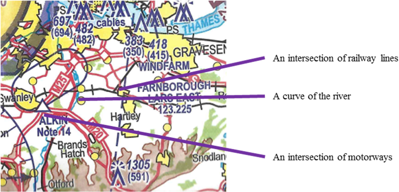
Visual navigation was common for pilots flying fixed-wing and ultralight aircraft in the three countries. For flights over land, pilots selected prominent landmarks during the pre-flight planning stage. These included lakes, rivers, distinctive buildings (for example, a factory) and motorways and in Norway, fjords. However, these did not include towns, urban roads and valleys as such features are not always distinctive. The pilots stated that the combination of landmarks for a position can reduce the likelihood of their loss of geographical awareness. For example, in Figure 1, the crossing of railway lines is located to the east of a curve in a river, whilst west of the river is a crossing of motorways.

Figure 1. Combination of landmarks (NATS, 2016).
The selection of landmarks was related to the familiarity of participants with the area. Visual navigation in an area of familiarity to the pilots, that is an area in which they often fly, was stated to be easier than in an unfamiliar area because of what they expected to see, for example, a factory to the east of a known town. Pilots often stated that ‘they knew the area’, implying that flying in unfamiliar areas can be challenging and was perceived as risky by four pilots, three of whom had recently migrated to the country in which they were interviewed. In such areas, pilots might not recognise the visual references and find it difficult to comprehend the radio dialogues with other pilots and air traffic controllers due to the accents spoken and their lack of knowledge of the names of landmarks. This familiarity can explain why glider pilots did not state any landmarks in their route selection since they typically fly over a relatively small area near to their departure aerodrome.
In visual navigation, it is always possible to identify a landmark incorrectly due to the phenomenological issues discussed in Section 2. The pilots stated that it is possible for them to fail to correctly identify a landmark or indeed fail to see the landmark at all for a variety of reasons. The changing of the seasons gives a glimpse of this issue, for example, the colours of terrain differ between seasons and when it snows, the terrain is white making it difficult to distinguish any landmarks at all. On the other hand, in summer the visibility is lower due to the humidity. Such issues with terrain must be considered by those GA pilots who fly infrequently, since they may find it difficult to recognise landmarks. For example, most pilots, especially ultralight and glider pilots, rarely fly between October and March due to the weather conditions and therefore see very different landscapes in the spring compared to the previous autumn. Furthermore, terrain colours also vary given the position of the sun, for example, morning and noon, sunny and cloudy day.
The pilots of fixed-wing and glider aircraft stated that another important aspect affecting their ability to see landmarks is the flying altitude as these appear differently to them from different altitudes, for example, a town looks smaller from 5,000 feet than from 1,000 feet, and thus, pilots need to train in order to perceive the relative size of features. Hence, towns are rarely selected as landmarks. Landmark identification is even more challenging for glider pilots, who can fly up to Flight Level (FL) 90 from where visual references are difficult to see. Furthermore, gliders turn tightly within a column of rising air and this manoeuvre requires a deep degree of concentration to keep their aircraft in the air and thus they need some time to match their position using paper charts. A glider pilot also stated that current aeronautical charts fail to show the information needed for gliding. Hence, glider pilots would benefit from aeronautical charts that cover a smaller area than those currently illustrated on the aeronautical charts and further show distinctive features from the typical gliding altitudes.
4.2. Radio-based navigation
While eight out of the 20 fixed-wing pilots mentioned radio-based navigation, it was not mentioned by any of the pilots of ultralight and glider aircraft, probably due to their flying style. Pilots that would have navigated with VORs selected their flight route based on the location of the VORs pre-flight. These pilots also used visual navigation, based on paper aeronautical charts and electronic displays. The pilots did not make any comments regarding the impact of such a navigation method on their performance, although it is evident that radio-based navigation cannot be the sole means of navigation.
4.3. Space-based navigation
Space-based navigation was conducted by using either an independent GNSS receiver or a tablet device. Both technologies visualise the aircraft's position on an electronic display that is likely to show the terrain and the airspace boundaries. Independent receivers were used by those pilots who flew either a fixed-wing or a glider aircraft. Glider pilots benefit from these devices because they are immediately aware of the aircraft's position in relation to controlled and restricted airspace after they stop circling, especially at high altitudes, for example, FL90, using the geographic coordinates. At lower altitudes, pilots of fixed-wing aircraft navigate using fewer fixes, that is, references with predefined coordinates, in order to ensure they fly their planned route.
The pilots stated that space-based navigation has improved their navigation in two situations. The first is when pilots fly over the sea where no landmark is available. The second is when pilots fly very close to controlled and restricted airspace that must not be infringed, for example, flying in a narrow uncontrolled airspace formed by restricted airspace, as in the Gulf of Finland, shown in Figure 2. Thus, space-based navigation enhances their geographical awareness when the technologies reliably estimate the aircraft's position.

Figure 2. Narrow uncontrolled airspace in the Gulf of Finland (Air Navigation Services Finland, 2017).
Space-based navigation was also used by pilots flying ultralight aircraft; however, these pilots were more likely to use tablets rather than independent receivers as the former significantly reduces the paper documents needed on board, especially in an open-cockpit ultralight aircraft. The significant reduction of the amount of paper documents required was perceived to be an advantage by the pilots who fly the other two types of aircraft. Furthermore, the major reduction in the time spent to calculate the aircraft's position in-flight is another key advantage, as pilots can therefore spend more time undertaking other tasks, for example, handling the aircraft or communicating by radio and maintaining a good look-out. Space-based navigation aids can also support pilots unfamiliar with an area. For example, a pilot, who grew up in another country in which they gained their flying experience was interviewed in the UK and stated that they chose to fly solo rather than with a peer as an individual can navigate using the tablet.
Regardless of the advantages of such devices, pilots also stated their drawbacks. A loss of situational awareness is possible when they rely solely on these technologies. For example, pilots might fail to notice that their aircraft travels faster than anticipated due to a stronger than forecast wind and subsequently fly into an airspace area other than that planned. Furthermore, especially with tablets, pilots might stare at their display and only monitor the aircraft's symbol, rather than compare the features on the ground with that on the display as well. Such a visual scan was believed to be employed by their peers while flying VFR. The problem is that these apps can fail, as experienced by the participants, for example, the app ‘freezes’, the measurements are inaccurate (technical details were not provided) or the presentation of information might be poor (for example, priorities of information presented, selection of colour) and thus, pilots monitor inaccurate information. In addition, the letters on the tablet's display can be small, especially for long-sighted pilots and the size of the display can be small for people with fingers that are thicker than the average. In turn therefore, such pilots face problems in utilising the app.
Failures of such devices can originate from a variety of sources: a weak internet connection, a weak satellite signal and a technical failure of the tablet's components, programs and the app itself. The tablet can also run out of battery power, an issue that is an on-going challenge for electronic devices. Given that GA pilots can often fly for more than an hour, their devices can run out of battery during the return flight to their home aerodrome and during cross-country flights. Although portable chargers are currently available, this type of failure is always possible, and pilots need to be prepared to switch to an alternative method of navigation or a back-up navigation system. Should such a situation occur, the question remains as to whether the pilot can successfully change methods or navigation systems while airborne.
Finally, the fact that apps installed in tablets are used for both planning and navigation and that planning is completed quickly in comparison to paper-based planning means that pilots are tolerant to making decisions in-flight. For example, in the situation that a pilot's request to enter controlled airspace is rejected, they will modify their route on the tablet and fly the best alternative route given their current situation, for example, close to controlled airspace. Pilots who are over-reliant on the reliability of their GNSS receivers can fly 100 feet to the side or below controlled airspace. At such a distance, the aircraft can drift and stray into controlled airspace. The ability to re-plan easily coupled with the excessive confidence placed on the reliability of these devices, can result in operational and safety air traffic management problems in controlled airspace. For these reasons, pilots need to systematically monitor their track and correct their heading accordingly in order to accommodate any dynamic changes in the weather.
4.4. Combination of navigation methods
As shown in Table 2, it is evident that pilots are likely to use a combination of navigation methods. Most pilots navigate with an electronic device and a Global Positioning System (GPS) receiver and thus, paper aeronautical charts are infrequently used. It is remarkable though that almost all the fixed-wing pilots that used a tablet also used an independent GNSS receiver. It can be speculated that these pilots were already equipped with an independent GNSS receiver when they started using a tablet. Most pilots stated that the first time they used the tablet was approximately two years ago. Pilots of the other two aircraft designs were likely to use only a sole navigation method, for example, visual navigation with paper aeronautical charts. Pilots of fixed-wing aircraft that navigated using radio aids, such as VORs, also used paper aeronautical charts, GNSS receivers and tablets. Pilots that used a paper map either navigated visually or used satellites.
5. DISCUSSION
The three navigation methods are summarised in Table 3, and they each have their limitations. In visual navigation, pilots rely on their eyesight, which is vulnerable to the phenomenological issues outlined in Section 2, to correctly match the landmark on the ground with that on the aeronautical chart. Radio-based navigation overcomes this limitation to a certain extent as pilots estimate their aircraft's position, given the position of the fixed ground-based radio navigation beacon. However, pilots continue to make mental calculations to maintain their geographical awareness. On the other hand, these mental calculations are less onerous in space-based navigation though this has the potential to change both the navigation and planning of GA VFR pilots in both a positive and negative manner; for example, from strategic to tactical decision-making, as discussed in Section 2. Furthermore, space-based navigation, especially using tablets, has certain technological limitations such as battery life and processor speed.
Table 3. Summary of results of the three navigation methods used by GA VFR pilots.

It is evident from this study that GA pilots are likely to use a combination of methods. Paper aeronautical charts will be used less often as pilots shift towards tablets with appropriate apps installed, in conjunction with an independent GNSS receiver. Hence space-based navigation can overcome the limitations of visual and radio-based navigation. While independent GNSS receivers specifically designed for aviation are used by the majority of pilots, particularly those who fly either a fixed-wing or a glider aircraft, pilots are willing to use tablets and appropriate apps in addition to such independent receivers. Tablets have become increasingly popular and can be used for both flight planning and navigation, as well as for other activities during a pilot's daily life. Therefore, the costs of buying such a device are relatively lower when compared to an independent receiver. This has become a motivating factor for GA recreational pilots, who are sensitive to cost, and especially so for ultralight aircraft pilots.
Given the technologies on board an ultralight aircraft, pilots must ensure that they navigate accurately because they may not carry a radio device to confirm their aircraft's position with other pilots and air traffic controllers. In the situation where such an ultralight aircraft infringes controlled airspace, the pilot is not contactable by the air traffic controller and this situation imposes a considerable safety risk as the air traffic controller has no control over the infringing aircraft.
Furthermore, it is evident that the monitoring undertaken by VFR pilots has changed due to the employment of space-based navigation methods. Such pilots might have changed their order of visual scan, in that they look more at the panel of the aircraft rather than outside and thereby fail to see traffic in conflict. This study further implies that the changes in navigation also affect flight planning. Pilots can make more flight-route-related decisions in-flight than pre-flight and thus, they may not adequately account for critical aspects, for example, weather, which can lead to significant deviations of the aircraft from its initially planned route. Such unnoticed drift may cause the aircraft to stray into controlled and restricted airspace, or indeed cause the pilot to be lost. In such situations, especially if the aircraft appears in controlled airspace, operational and safety problems arise in air traffic management.
As for the technological specifications, given that tablets are increasingly used by GA pilots, the specifications of their GNSS receiver and the limitations of internet connectivity while airborne should be clearly communicated to the GA users in order to ensure the suitability of various brands, generations of tablets and the potential sources that can degrade their performance. Finally, this paper is in agreement with the previous studies outlined in Section 2, in that digital interfaces need to improve. Pilots would benefit from ergonomically designed displays that meet their flying needs in terms of the presentation of information, concerning both human vision and touch senses.
6. CONCLUSIONS
Incorrect navigation by GA pilots poses a number of problems, primarily related to safety. This paper outlines the key features of the three most popular navigation methods used by GA VFR pilots and determines the impact of each navigation method on a pilot's flying performance. It highlights the key limitations of visual navigation using paper charts and the benefits to be gained from the incorporation of space-based navigation, by means of independent GNSS receivers specifically designed for aviation but also portable computers, such as tablets. While space-based navigation can support pilots in maintaining their geographical awareness, a pilot's reliance on this method can also degrade their performance, for example, in a failure to see traffic in conflict, especially in the absence of appropriate training. Furthermore, the improved awareness of an aircraft's position (continuous and accurate) may encourage pilots to select a route very close to controlled and restricted airspace indicating the strong relationship between flight planning and navigation. Due to various reasons, in such flights, the aircraft can stray into such airspace and cause operational and safety problems. The increasing use of space-based navigation points to the direction of future pilot training in order to safely plan and navigate using emerging technologies and this training should consider the profound differences across the diverse GA sector, such as fixed-wing, glider and ultralight aircraft. Furthermore, interfaces should be ergonomically designed to the needs of the GA pilots.
ACKNOWLEDGMENTS
The authors would like to thank Lloyds Register Foundation who funded this research. The authors would also like to thank the participants of this study as well as Per Julius Helweg, Heli Koivu, Armin Zuger and Bettina Bajaj who organised the interviews in Finland, Norway and UK. Finally, the authors would like to thank the Royal Institute of Navigation General Aviation Navigation Group for their advice in clarifying the paper.