


1. Introduction
Intraplate deformation is often ignored in geodynamic reconstructions because it is expressed in small-amplitude deformations that are often difficult to observe and quantify. This deformation, defined here as the deformation beyond the chain front, is often guided by the reactivation of deeply rooted faults (Lacombe & Mouthereau, Reference Lacombe and Mouthereau1999). The reactivation of these inherited structures induced by far-field stresses may accommodate the deformation, particularly when tectonic events such as continental collision occur at plate boundaries (Ziegler et al. Reference Ziegler, Cloetingh and van Wees1995, Reference Ziegler, van Wees and Cloetingh1998; Dèzes et al. Reference Dèzes, Schmid and Ziegler2004; Willingshofer & Sokoutis, Reference Willingshofer and Sokoutis2009; Willingshofer et al. Reference Willingshofer, Sokoutis, Luth, Beekman and Cloetingh2013; Dielforder et al. Reference Dielforder, Frasca, Brune and Ford2019). The tectonic heritage thus plays an important role, especially by localizing the deformation in these weakly deformed zones, as is the case, for example, in the central Indian Ocean (Chamot-Rooke et al. Reference Chamot-Rooke, Jestin and de Voogd1993; Beekman et al. Reference Beekman, Bull, Cloetingh and Scrutton1996), in the North Sea (Ziegler, Reference Ziegler1987; Nielsen et al. Reference Nielsen, Stephenson and Thomsen2007) or in the Paris Basin (Cazes et al. Reference Cazes, Torreilles, Bois, Damotte, Galdéano, Hirn, Mascle, Matte, Van Ngoc and Raoult1985). Intraplate deformation may be studied through the definition of the stress state from structural measurements (Constantin et al. Reference Constantin, Vergély and Cabrera2002) or from geophysical measurements such as velocity wave anisotropy (Fagereng et al. Reference Fagereng, Remitti and Sibson2010). More recent methods of quantifying the amplitude of movements from low-temperature thermochronology (Leprêtre et al. Reference Leprêtre, Barbarand, Missenard, Gautheron, Pinna Jamme and Saddiqi2017) or the age of movements (U–Pb dating of syn-faulting calcites (Beaudoin et al. Reference Beaudoin, Lacombe, Roberts and Koehn2018; Roberts et al. Reference Roberts, Drost, Horstwood, Condon, Chew, Drake, Milodowski, McLean, Smye, Walker, Haslam, Hodson, Imber and Beaudoin2020; Bilau et al. Reference Bilau, Rolland, Schwartz, Godeau, Guihou, Deschamps, Brigaud, Noret, Dumont and Gautheron2021) allow us to go further and to propose a precise timing of intraplate deformation, in order to determine how and why older faults are reactivated, and what the impact of those faults is.
So far, the degree of sensitivity of these inherited intraplate structures remains largely unknown. Do faults only react to major pulses at plate boundaries? Or do they constitute weak areas deforming through time long before and/or long after deformation peaks? Answering this question requires specifying the age of these deformations along inherited structures, which is often challenging due to a missing or limited syn-tectonic sedimentary record and very low rate of deformation.
Because it is known that the Pyrenean stresses were transmitted very far into the Pyrenean foreland (in the Paris Basin (Lacombe & Obert, Reference Lacombe and Obert2000); in eastern France (Bergerat, Reference Bergerat1987); and even in the UK (Parrish et al. Reference Parrish, Parrish and Lasalle2018)), in this study we investigate the effect of the Pyrenean compressive tectonics on the Cévennes Fault System (CFS) and related structures such as the Pic Saint-Loup thrust (Mattei, Reference Mattei1986) or the Dalle des Matelles (Petit & Mattauer, Reference Petit and Mattauer1995; Fig. 1b). The CFS constitutes the NW border of the South-East Basin, France (Fig. 1a). It is a major intraplate structure that has been reactivated several times during its history. Located NE of the Pyrenees and extending NE to the Alpine arc (Fig. 1a), this 400 km long fault system is known to be polyphased, its formation beginning during the Variscan cycle (Séguret & Proust, Reference Séguret and Proust1965; Arthaud & Matte, Reference Arthaud and Matte1975), continuing during the Tethys rifting, Pyrenean compression and Mediterranean rifting (Séguret & Proust, Reference Séguret and Proust1965; Arthaud & Mattauer, Reference Arthaud and Mattauer1969; Le Pichon et al. Reference Le Pichon, Pautot, Auzende and Olivet1971; Bodeur, Reference Bodeur1976; Roure et al. Reference Roure, Brun, Colletta and Van den Driessche1992; Séranne, Reference Séranne1999; Sanchis & Séranne, Reference Sanchis and Séranne2000; Séranne et al. Reference Séranne, Camus, Lucazeau, Barbarand and Quinif2002) and lasting until the Quaternary (although this recent history has sparked debate: see Ambert et al. Reference Ambert, Philip and Ritz1998; Lacassin et al. Reference Lacassin, Meyer and Benedetti1998; Mattauer, Reference Mattauer1998; Sébrier et al. Reference Sébrier, Bellier, Peulvast and Vergély1998). The CFS constitutes a good candidate to address the question of the sensitivity of intraplate inherited faults to the plate-edge deformation over long durations. Furthermore, this fault zone has been the subject of much recent discussion and preliminary work (Ritz et al. Reference Ritz, Baize, Ferry, Larroque, Audin, Delouis and Mathot2020) since 11 November 2019, when the Teil earthquake (Mw = 4.9, intensity VII to VIII EMS98) occurred along the La Rouvière Fault belonging to the CFS, although this fault had been considered inactive. This recent event also raises the question of the long-term evolution of such an intraplate fault system.

Fig. 1. Location of the study area and sampling outcrops. (a) Structural map of southern France after 1:1 000 000 BRGM geological map; (b) structural scheme and sampling outcrops (with stars). Modified using 1:50 000 BRGM geological maps.
In this study, we dated compressive or strike-slip related syn-faulting calcites from the southern half of the CFS by U–Pb geochronology. Our results are discussed in the light of a wider geodynamical frame and compared to the relative chronology previously established.
2. Geodynamic context
This study focuses on the Cévennes Fault System and adjacent structures located in the Languedoc region (Fig. 1a–b). This domain is characterized by a polyphased tectonic history that begins with the Variscan orogen formation. The latter resulted from a compressive tectonic regime associated with various stress field orientations until Carboniferous times (Arthaud & Matte, Reference Arthaud and Matte1975; Blés et al. Reference Blés, Bonijoly, Castaing and Gros1989; Faure et al. Reference Faure, Lardeaux and Ledru2009). After that, during the Permian–Triassic, a long period of ∼N–S extension in the south of Massif Central is associated with the formation of basins with clastic deposits of several thousand metres and NE–SW-trending faults such as the CFS (Blés et al. Reference Blés, Bonijoly, Castaing and Gros1989).
During the Triassic to the Early/Middle Jurassic, an extensional episode (Dreyfus & Gottis, Reference Dreyfus and Gottis1948) due to the east–west opening of the Tethys Ocean in southern France (Lemoine, Reference Lemoine1982; Dumont et al. Reference Dumont, Lemoine and Tricart1984; Dercourt et al. Reference Dercourt, Zonenshain, Ricou, Kazmin, Le Pichon, Knipper, Grandjacquet, Sbortshikov, Geyssant, Lepvrier, Pechersky, Boulin, Sibuet, Savostin, Sorokhtin, Westphal, Bazhenov, Lauer and Biju-Duval1986; Lemoine & Graciansky, Reference Lemoine and Graciansky1988; Bonijoly et al. Reference Bonijoly, Perrin, Roure, Bergerat, Courel, Elmi and Mignot1996; Frizon de Lamotte et al. Reference Frizon de Lamotte, Raulin, Mouchot, Wrobel, Blanpied and Ringenbach2011) reactivated the CFS as a normal fault dipping SE (Séguret & Proust, Reference Séguret and Proust1965; Roure et al. Reference Roure, Brun, Colletta and Van den Driessche1992).
During the Early Cretaceous, a major reorganization of the Ligurian Tethys margin led to the formation of the Durancian Isthmus, separated by two marine troughs (the Vocontian and the Pyrenees–Provence basins) (Masse & Philip, Reference Masse and Philip1976). Extensive structures observed near and north of Montpellier have been associated to this event (Dreyfus & Gottis, Reference Dreyfus and Gottis1948; Arthaud & Séguret, Reference Arthaud and Séguret1981; Marchand et al. Reference Marchand, Séranne, Bruguier and Vinches2020). Further west, the opening of the Biscay Bay controlled by the rotation of the Iberian plate led to the formation of narrow Pyrenean basins filled up by turbidites (Choukroune & Mattauer, Reference Choukroune and Mattauer1978; Puigdefàbregas & Souquet, Reference Puigdefàbregas and Souquet1986; Debroas, Reference Debroas1987; Roest & Srivastava, Reference Roest and Srivastava1991; Rosenbaum et al. Reference Rosenbaum, Lister and Duboz2002; Sibuet et al. Reference Sibuet, Srivastava and Spakman2004; Jammes et al. Reference Jammes, Manatschal, Lavier and Masini2009; Tugend et al. Reference Tugend, Manatschal, Kusznir, Masini, Mohn and Thinon2014; Tavani et al. Reference Tavani, Bertok, Granado, Piana, Salas, Vigna and Muñoz2018).
Shortening in the Pyrenean belt began as early as the Coniacian according to Andrieu et al. (Reference Andrieu, Saspiturry, Lartigau, Issautier, Angrand and Lasseur2021). This early episode is known throughout the Pyrenean belt as the first phase of compressive deformation (Filleaudeau et al. Reference Filleaudeau, Mouthereau and Pik2012; Mouthereau et al. Reference Mouthereau, Filleaudeau, Vacherat, Pik, Lacombe, Fellin, Castelltort, Christophoul and Masini2014; Grool et al. Reference Grool, Ford, Vergés, Huismans, Christophoul and Dielforder2018; Ternois et al. Reference Ternois, Odlum, Ford, Pik, Stockli, Tibari, Vacherat and Bernard2019). It is also highlighted in many studies focusing on the geodynamic history of the South-East Basin – in Provence (Lacombe et al. Reference Lacombe, Angelier and Laurent1992; Leleu et al. Reference Leleu, Ghienne and Manatschal2005; Espurt et al. Reference Espurt, Hippolyte, Saillard and Bellier2012) as well as in Languedoc (Mattauer & Proust, Reference Mattauer and Proust1962; Freytet, Reference Freytet1971; Arthaud & Séguret, Reference Arthaud and Séguret1981; Combes et al. Reference Combes, Peybernès, Fondecave-Wallez, Séranne, Lesage and Camus2007; Schreiber et al. Reference Schreiber, Giannerini and Lardeaux2011; Hemelsdaël et al. Reference Hemelsdaël, Séranne, Husson and Ballas2021)-. In the latter, the record of the Pyrenean orogen early building begins in the Campanian–Maastrichtian period, according to many authors (Freytet, Reference Freytet1971; Combes et al. Reference Combes, Peybernès, Fondecave-Wallez, Séranne, Lesage and Camus2007; Schreiber et al. Reference Schreiber, Giannerini and Lardeaux2011), although Arthaud & Séguret (Reference Arthaud and Séguret1981) attribute this beginning to the Palaeocene – Early Eocene. Although this early event seems difficult to constrain in time, Mattauer & Proust (Reference Mattauer and Proust1962), Arthaud & Séguret (Reference Arthaud and Séguret1981), and Hemelsdaël et al. (Reference Hemelsdaël, Séranne, Husson and Ballas2021) mainly associate the Montpellier Fold formation with this phase of shortening.
The Lutetian period in the study area corresponds to the deposit of lacustrine limestones, in a quiescent tectonic context (Arthaud & Séguret, Reference Arthaud and Séguret1981). The so-called Pyrenean phase of Upper Eocene age is associated in Languedoc with (1) the formation of Bartonian breccias and Priabonian fluvial conglomerates with internal onlap illustrating syn-depositional deformation (Séranne et al. Reference Séranne, Couëffé, Husson, Baral and Villard2021), (2) the formation or reactivation of most major structures such as the Pic Saint-Loup thrust (Arthaud & Séguret, Reference Arthaud and Séguret1981) (Fig. 1b), and (3) a σ1 direction of the main stress of ∼N15°E as recorded for instance on the Dalle des Matelles (Fig. 1b) (Arthaud & Laurent, Reference Arthaud and Laurent1995; Petit & Mattauer, Reference Petit and Mattauer1995). Therefore, the Languedoc region records two tectonic episodes associated with the convergence of the Iberian and Eurasian plates at ages ∼ Late Cretaceous – early Eocene and late Eocene (Bartonian–Priabonian). Distinction between these two tectonic phases is, however, not recorded in the intraplate domain to the north, where recent work shows a weak but continuous record of deformation in the Grands Causses area (Fig. 1a) from the Late Cretaceous to the late Eocene (Parizot et al. Reference Parizot, Missenard, Vergely, Haurine, Noret, Delpech, Barbarand and Sarda2020). Regarding the CFS, as well as the Nimes and Durance faults, many authors show reverse-sinistral strike-slip motion during Palaeogene times at the origin of elevated horsts such as the Jurassic Thaurac plateau (between Ganges and Saint-Bauzille-de-Putois; Fig. 1b) (Séguret & Proust, Reference Séguret and Proust1965; Arthaud & Mattauer, Reference Arthaud and Mattauer1969; Lacombe & Jolivet, Reference Lacombe and Jolivet2005; Hemelsdaël et al. Reference Hemelsdaël, Séranne, Husson and Ballas2021; Séranne et al. Reference Séranne, Couëffé, Husson, Baral and Villard2021). This motion is coeval with E–W compressive structures growth, and Bodeur (Reference Bodeur1976) describes a strike-slip throw of almost 15 km along the CFS.
The Priabonian period for Languedoc corresponds to a switching from compression to extension (Séranne et al. Reference Séranne, Couëffé, Husson, Baral and Villard2021). Since this time, and until the Aquitanian (Oudet et al. Reference Oudet, Münch, Borgomano, Quillevere, Melinte-Dobrinescu, Demory, Viseur and Cornee2010), the geodynamic context of the Mediterranean domain (Fig. 1a) is associated with convergence of Eurasia and Africa plates and the retreat of the African slab to the SE that induced the opening of the Gulf of Lion and the rotation of the Corso-Sardinian Block. This extensional phase involves the whole Southern European margin (Le Pichon et al. Reference Le Pichon, Pautot, Auzende and Olivet1971; Séranne, Reference Séranne1999; Jolivet et al. Reference Jolivet, Romagny, Gorini, Maillard, Thinon, Couëffé, Ducoux and Séranne2020; Hemelsdaël et al. Reference Hemelsdaël, Séranne, Husson and Ballas2021; Séranne et al. Reference Séranne, Couëffé, Husson, Baral and Villard2021), and is characterized by (1) a NW–SE opening direction recorded in the whole Languedoc region (Séguret & Proust, Reference Séguret and Proust1965; Arthaud et al. Reference Arthaud, Ogier and Séguret1981), and (2) the reactivation of the CFS with normal kinematics, which is responsible for the development of NE–SW-trending Oligocene basins (e.g. the Montoulieu and Alès basins; Fig. 1a–b) (Le Pichon et al. Reference Le Pichon, Pautot, Auzende and Olivet1971; Roure et al. Reference Roure, Brun, Colletta and Van den Driessche1992; Séranne, Reference Séranne1999; Sanchis & Séranne, Reference Sanchis and Séranne2000).
Since the beginning of Neogene times, the region has been relatively quiet from a tectonic point of view, although Roy & Trémolières (Reference Roy and Trémolières1992) documented Miocene N–S-trending reverse faults in the Alès basin and Bergerat (Reference Bergerat1987) reported activity of the CFS in a dextral movement during the Aquitanian, associated with a tectonic episode recorded on the whole European platform and interpreted as a resumption of the Africa/Europe convergence. According to Séranne et al. (Reference Séranne, Camus, Lucazeau, Barbarand and Quinif2002), this major fault was subsequently reactivated during post-Langhian – pre-Messinian times. Currently, the Teil earthquake (11 November 2019) located at the NE extremity of the CFS reveals ongoing activity (Ritz et al. Reference Ritz, Baize, Ferry, Larroque, Audin, Delouis and Mathot2020).
3. Samples and methods
A total of 54 calcites were microstructurally studied and sampled in 22 outcrops on decimetric to metric faults. We only focused on syn-faulting calcites corresponding to calcites with stair-step morphology demonstrating their syntectonic origin (Vergely & Xu, Reference Vergely and Xu1988) (Fig. 2a–b). Moreover, we decided to sample only calcites with a single striation generation, in order to limit age mixing and the possible reopening of the isotopic system.
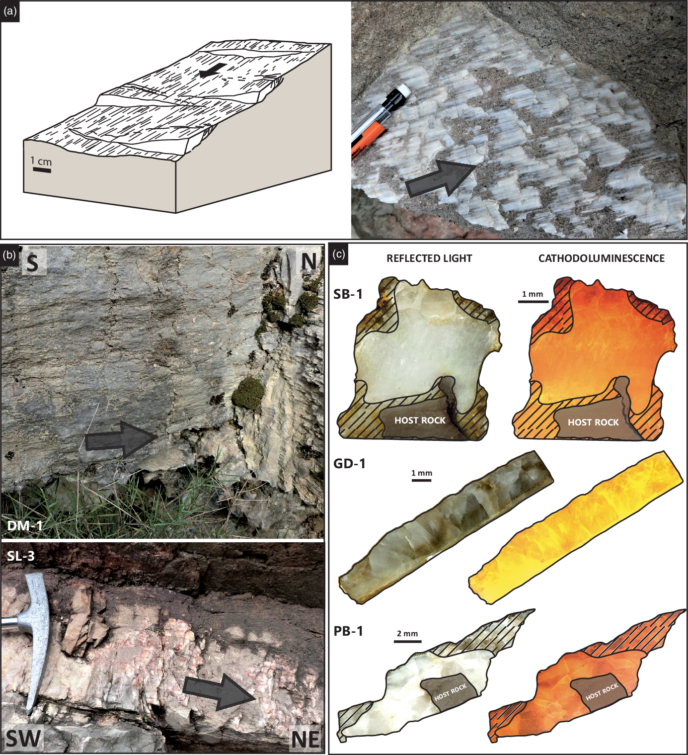
Fig. 2. Syn-faulting calcite samples. (a) Schematic sketch of a portion of a fault mirror with fault-related calcites (modified from Vergely & Xu, Reference Vergely and Xu1988) and example of a syn-faulting calcite observed in the field. (b) Illustrations of two sinistral fault-related calcites observed near Les Matelles and Puéchabon (Fig. 1b). (c) Petrographic observations: reflected light and CL images of syn-faulting calcites. See text and the online Supplementary Material (https://doi.org/10.1017/S0016756822000152) for details of petrographic observations.
Petrographic and geochemical analyses were performed on polished samples mounted in epoxy. Petrographic observation was conducted using a binocular, as well as optical and cathodoluminescence (CL), microscopy. CL observations were carried out on an Olympus BX41 microscope coupled to a Cathodyne® cold-cathode cathodoluminescence device (NewTec, Nîmes, France) operating at 10–12 kV and 200–300 µA, and a Qicam Fast® 1394 digital camera (TELEDYNE QIMAGING®, Surrey, Canada).
Calcite samples were dated by U–Pb geochronology using a high-resolution inductively coupled plasma mass spectrometry (HR-ICP-MS) Element XR® from Thermo Scientific® coupled to a Laser Ablation system (LA) ArF 193 nm from Teledyne Photon Machines® at the Paris-Saclay University – GEOPS laboratory. Details on syn-faulting calcite samples and methods can be found in the Supplementary Material (available online at https://doi.org/10.1017/S0016756822000152).
4. Results
Dating was successful for ∼25 % of the samples (13/54 samples). Dated samples correspond to syn-kinematic calcites with single generation (see for instance Fig. 2a–b) associated with reverse and strike-slip faults. Petrographic observations in reflected light and CL have been used to delimit zones for U–Pb geochronology: areas where calcite crystals were not milky white or clear white grey in reflected light were excluded. These excluded areas generally correspond to the edges of the samples, and often show a colour variation in CL in comparison with the determined ablation areas. In CL microscopy, calcite crystals show a relatively homogeneous luminescence without zoning (Fig. 2c) (see the online Supplementary Material at https://doi.org/10.1017/S0016756822000152 for more details and petrographic illustrations).
4.a. SB samples
‘SB’ calcites were sampled on an outcrop corresponding to a Malm limestone lens, at Saint-Bauzille-de-Putois (Figs 1b, 3a). This outcrop is 150 m long and a few metres wide over a height of 2 m, along the Demoiselles cave road. The lens, oriented 40° N, is included between Oligocene formations to the SE and Lower Cretaceous formations to the NW and is separated from them by two major faults of the CFS. The outcrop is strongly deformed with vertical sigmoidal planes, attesting to a reverse-sinistral activity of the CFS. Four fault-related calcites were sampled in the Jurassic formation on these vertical planes. SB-1 and SB-4 come from dextral strike-slip faults oriented N78°–84°N – p58°NE and N76°SV – p51°NE respectively (Fig. 3a). SB-2 and SB-3 are sinistral strike-slip fault-related calcites oriented N66°–74°S – p17°SO and N59°–84°N – p0° respectively (Fig. 3a). U–Pb ages are c. 40 Ma (Lutetian/Priabonian): 36.6 ± 1.8 Ma for sample SB-1, 39.6 ± 3.4 Ma for SB-2, 40.8 ± 3.3 Ma for SB-3 and 41.3 ± 2.1 Ma for SB-4 (Fig. 4).
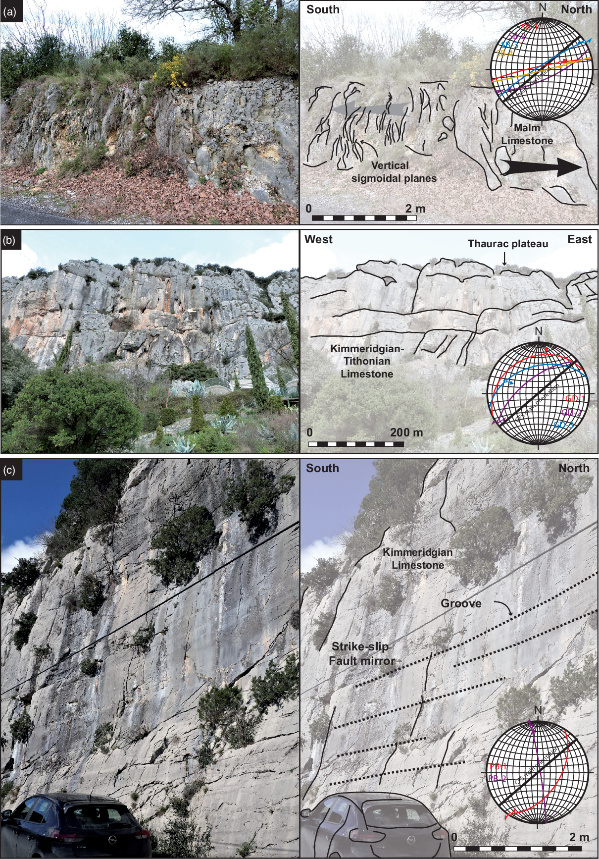
Fig. 3a. Outcrop illustrations and stereonet showing the dated fault plane and slickenside. (a) Malm limestone lens with vertical sigmoidal planes at Saint-Bauzille-de-Putois (Fig. 1b); ‘SB’ samples come from this outcrop. (b) Entrance to the ‘Demoiselles caves’ and Kimmeridgian–Tithonian limestone cliff in the background, from which the ‘GD’ calcites were sampled. The bedding is sub-horizontal. (c) Large fault mirror (CFS) with grooves in the Kimmeridgian Formation, SW of Pégairolles-de-Buèges (Fig. 1b). ‘PB’ calcites were sampled from small fault mirrors at the bottom of this outcrop. The bedding is sub-horizontal. (d) Metric-scale east–west axis fold near the Corconne fault, in the Berriasian sub-horizontal Formation (Fig. 1b) ‘SL-1’ sample comes from the fault-propagation fold affecting these limestones. (e) Bartonian Formation currently vertical with conglomerates and reverse faults (from which the ‘SL-2’ calcite has been sampled), south of Saint-Martin-de-Londres (Fig. 1b). (f) Strike-slip fault-related calcite on a Kimmeridgian–Tithonian outcrop (Puéchabon outcrop; Fig. 1b). ‘SL-3’ sample comes from this fault mirror. The formation is tilted to the NE. (g) Malm Dalles des Matelles, near the Matelles Fault (Petit & Mattauer, Reference Petit and Mattauer1995) (Fig. 1b), from which the DM-1 sample was collected. The bedding is sub-horizontal.

Fig. 3b.
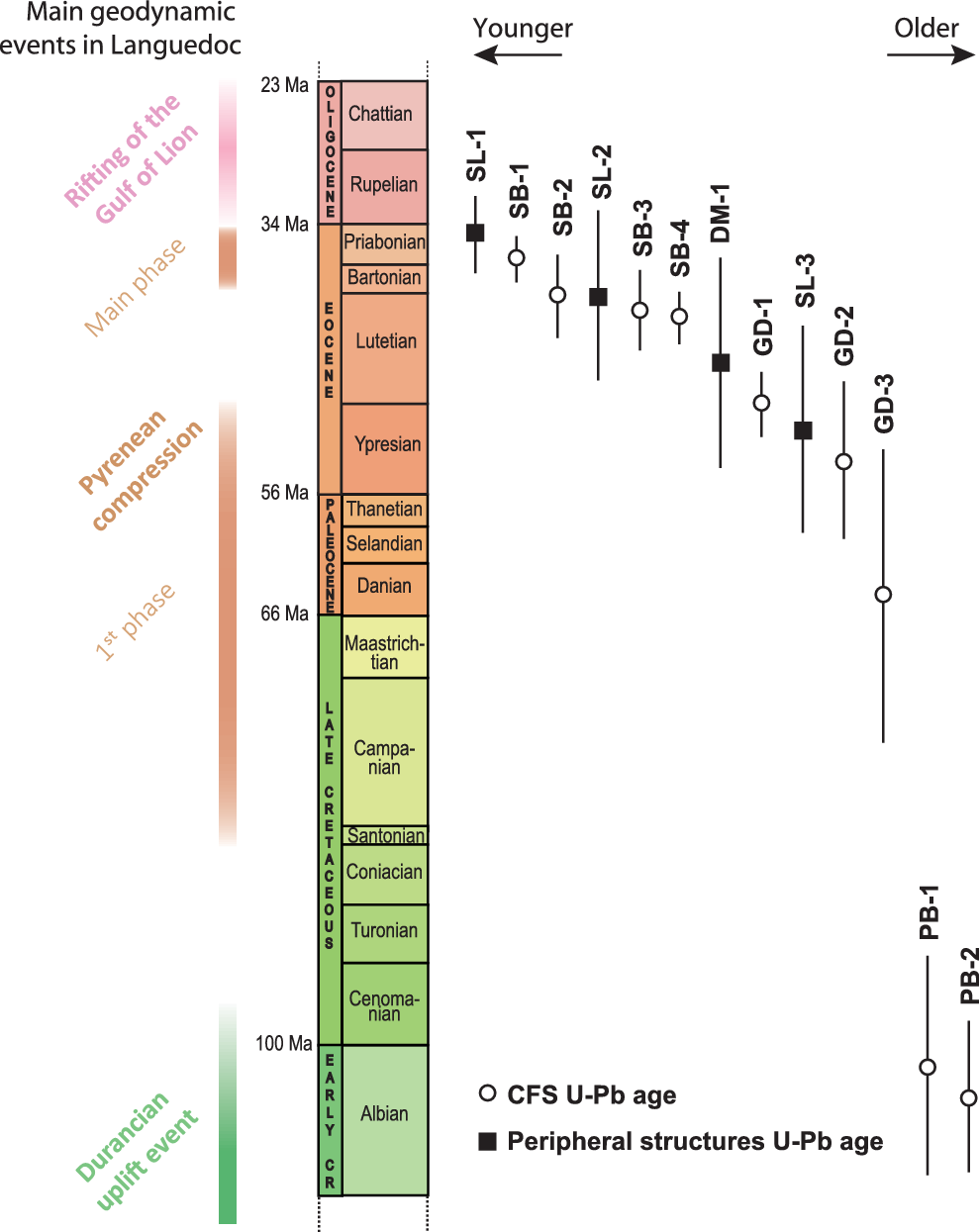
Fig. 4. Results of syn-faulting calcite U–Pb geochronology in comparison with the deformation chronology in Languedoc domain. The U–Pb ages are represented by the white circles for samples of the CFS and black squares for samples from related structures, all with their propagated uncertainties (2σ).
4.b. GD samples
‘GD’ calcites come from another outcrop located 600 m west of the entry of the Demoiselles cave (Figs 1b, 3b). It corresponds to a 30 m high Kimmeridgian–Tithonian limestone cliff, forming the southern end of the Thaurac plateau. This outcrop is further separated from the Lower Cretaceous outcropping a few metres to the south by a secondary fault of the CFS, 8 km long in a 60° N direction. Three calcite samples were dated and correspond to two dextral fault-related calcites (GD-1: N63°–29°NO – p56°N; GD-3: N73°–47°NO – p45°W) and one sinistral strike-slip fault-related calcite (GD-2: N52°–65°NO – p7°SO) (Fig. 3b). The U–Pb ages are respectively 48.3 ± 2.7 Ma (Early Eocene; GD-1), 52.9 ± 6.3 Ma (Early Eocene; GD-2) and 63.8 ± 11.9 Ma (Palaeocene; GD-3) (Fig. 4).
4.c. PB samples
At 3 km SW of Pégairolles-de-Buèges, a large fault mirror, 20 m wide and >15 m high, in a Kimmeridgian formation corresponds to the major fault of the CFS according to the 1:50 000 French Geological Survey (BRGM) geological map of Le Caylar (Alabouvette et al. Reference Alabouvette, Bodeur, Mattei, Lopez, Rançon and Paloc1987; Figs 1b, 3c). This mirror includes large grooves without calcite. Within 5 m of the main mirror, small metric fault planes are composed of fault-related calcites. Two dated calcite samples were collected on these strike-slip faults, corresponding to a sinistral fault (PB-1: N34°–52°SE – p2°SO) and a dextral fault (PB-2: N171°–86°NE – p9°NO) (Fig. 3c). The U–Pb ages indicate an activity of these faults during Albian times: 101.8 ± 8.9 Ma for PB-1 and 104.2 ± 6.2 Ma for PB-2 (Fig. 4).
4.d. Peripheral structures: SL and DM samples
Fault-related calcites collected south of the Saint-Martin-de-Londres basin (SL-1 to 3 and DM-1) and corresponding to peripheral metric-scale faults of the CFS (10 km to the SW) have been dated. SL-1 is located on a fault plane corresponding to the fault-propagation fold affecting Berriasian limestones, near the Corconne Fault, on the NE termination of the Pic Saint-Loup thrust (near D1 road) (Figs 1b, 3d). This sample is related to a reverse fault (N90°–85°S – p90°), and its U–Pb age is 34.6 ± 3.2 Ma (Priabonian; Fig. 4). SL-2 is a syn-faulting calcite sampled in the Bartonian Formation, SE of Saint-Martin-de-Londres (Figs 1b, 3e). The present-day orientation shows a reverse fault (N120°–30°NE – p47°NO). When corrected from strata-tilting, this fault is a normal fault (Fig. 3e). U–Pb age is 39.9 ± 6.8 Ma (Bartonian; Fig. 4). Considering that this age is similar to that of other dated strike-slip or reverse faults (SB-1, SB-2, SB-3, SB-4, SL-1), it is likely that this fault plane results from a compressive regime in a formerly folded formation. Calcite SL-3 comes from a Kimmeridgian–Tithonian outcrop, NW of Puéchabon, on the SW lateral termination of the Pic Saint-Loup thrust (Figs 1b, 3f). It corresponds to a sinistral strike-slip fault-related calcite (SL-3: N43°–47°SE – p13°NE; Fig. 3f) with an Ypresian U–Pb age of 50.4 ± 8.3 Ma (Fig. 4). Finally, a sinistral strike-slip fault-related calcite (DM-1: N176°–86°O – p0°) from the Malm Dalle des Matelles (near the Matelles Fault; Figs 1b, 3g; Petit & Mattauer, Reference Petit and Mattauer1995) has been dated at 45.0 ± 8.5 Ma (Fig. 4). Exact locations of dated samples are given in the online Supplementary Material at https://doi.org/10.1017/S0016756822000152.
5. Discussion
5.a. Activity of the CFS during Albian times
The ages obtained on syn-faulting calcites, associated with the CFS, coupled with the structural data, indicate a reactivation of the CFS during the Albian (Fig. 4). This deformation episode is also recorded in the Montoulieu Basin (north of Saint-Bauzille de Putois; Fig. 1b) by an unconformity between the Neocomian formations and the base of the Upper Cretaceous deposits (Alabouvette et al. Reference Alabouvette, Arthaud, Bodeur, Paloc, Séguret, Le Strat, Ellenberger, Macquar and Coumoul1988). At the scale of the South-East Basin, the major regional strike-slip structures were also active during the Albian, with a dextral movement for the Toulourenc Fault (corresponding to the Ventoux thrust since its tectonic inversion in the Cenozoic; Montenat et al. Reference Montenat, Janin and Barrier2004), and a sinistral movement for the Nîmes and Durance faults (Montenat et al. Reference Montenat, Janin and Barrier2004; Fig. 5a). This reactivation of the NE–SW inherited structures is coeval with (1) denudation recorded by thermochronological data in the Massif Central 100–130 Ma ago (Barbarand et al. Reference Barbarand, Lucazeau, Pagel and Seranne2001, Reference Barbarand, Préhaud, Baudin, Missenard, Matray, François, Blaise, Pinna-Jamme and Gautheron2020; Peyaud et al. Reference Peyaud, Barbarand, Carter and Pagel2005; Fig. 5a), (2) tectonics highlighted by Guyonnet-Benaize et al. (Reference Guyonnet-Benaize, Lamarche, Masse, Villeneuve and Viseur2010) and (3) formation of bauxites along the Durancian Isthmus (Combes, Reference Combes1990; Chanvry et al. Reference Chanvry, Marchand, Lopez, Séranne, Le Saout and Vinches2020; Marchand et al. Reference Marchand, Séranne, Bruguier and Vinches2020; Fig. 5a).

Fig. 5. Updated compilation of structural and palaeogeographical maps of southern France. (a) Mid-Cretaceous times. Modified after Marchand et al. (Reference Marchand, Séranne, Bruguier and Vinches2020), and completed from Combes (Reference Combes1990), Barbarand et al. (Reference Barbarand, Lucazeau, Pagel and Seranne2001), Montenat et al. (Reference Montenat, Janin and Barrier2004), Peyaud et al. (Reference Peyaud, Barbarand, Carter and Pagel2005) and Olivetti et al. (Reference Olivetti, Balestrieri, Godard, Bellier, Gautheron, Valla, Zattin, Faccenna, Pinna-Jamme and Manchuel2020). The locations of basins and NE–SW faults on the sketch map come from Peybernès & Souquet (Reference Peybernès and Souquet1984), Mencos et al. (Reference Mencos, Carrera and Muñoz2015) and Tavani et al. (Reference Tavani, Bertok, Granado, Piana, Salas, Vigna and Muñoz2018). (b) Priabonian times after Arthaud & Mattauer (Reference Arthaud and Mattauer1969), Mattauer & Henry (Reference Mattauer and Henry1974), Arthaud & Séguret (Reference Arthaud and Séguret1981), Plaziat (Reference Plaziat1981), Lacombe & Jolivet (Reference Lacombe and Jolivet2005), Vacherat et al. (Reference Vacherat, Mouthereau, Pik, Huyghe, Paquette, Christophoul, Loget and Tibari2017) and Séranne et al. (Reference Séranne, Couëffé, Husson, Baral and Villard2021).
Our U–Pb dataset and geochronological data from previous authors testify to a major deformation event in the intraplate domain during the Albian, as recorded in the Causses domain area at that time by the formation of normal faults, according to Parizot et al. (Reference Parizot, Missenard, Vergely, Haurine, Noret, Delpech, Barbarand and Sarda2020). We propose that this event could be a consequence of the opening of the Pyrenean basins to the south in Lower Cretaceous times (Choukroune et al. Reference Choukroune, Le Pichon, Séguret and Sibuet1973). Indeed, some recent studies have shown a major implication of the inherited NE–SW structures in the opening of the Pyrenean basins along a NE–SW axis, from the Santander Fault to the west to the Limone–Viozene northern Fault to the east (Jammes et al. Reference Jammes, Manatschal, Lavier and Masini2009; Tugend et al. Reference Tugend, Manatschal, Kusznir, Masini, Mohn and Thinon2014; Tavani et al. Reference Tavani, Bertok, Granado, Piana, Salas, Vigna and Muñoz2018). In this way, the activity of the CFS may be directly related to the formation of the extensive Pyrenean basins although a precise kinematic model remains to be established.
5.b. The activity of the CFS during the Pyrenean phase
Ages obtained on the fault-related calcites of the Demoiselles cave Fault (samples GD-1, GD-2, GD-3), from ∼76 to 45 Ma (2σ included), and Saint-Bauzille-de-Putois Fault (samples SB-1, SB-2, SB-3, SB-4), from ∼ 43 to 35 Ma (2σ included), show continuous tectonic activity during the whole Eocene (from Ypresian (GD-2) to Priabonian (SB-1); Fig. 4) and perhaps since the Palaeocene (GD-3; Fig. 4). We therefore assimilate all of these fault-related calcites to the Pyrenean episode at the origin of the reactivation of the CFS in reverse-sinistral movement throughout the Eocene (Séguret & Proust, Reference Séguret and Proust1965; Arthaud & Mattauer, Reference Arthaud and Mattauer1969; Arthaud & Séguret, Reference Arthaud and Séguret1981) (Fig. 5b).
The U–Pb ages obtained on the peripheral structures of the CFS (such as the Dalle des Matelles and the faults around the Pic Saint-Loup thrust) also point to a deformation phase during the Eocene. Although debatable due to analytical uncertainties, the U–Pb ages may reflect a continuous growth of the Pic Saint-Loup structure from the Ypresian to the Priabonian.
As a whole, this study highlights brittle deformation in the Languedoc region contemporary with the formation of the orogen in Palaeocene and Eocene times (Grool et al. Reference Grool, Ford, Vergés, Huismans, Christophoul and Dielforder2018), as also observed during the emplacement of the SE Pyrenean thrust sheet sequence (see fig. 6 of Cruset et al. Reference Cruset, Vergés, Albert, Gerdes, Benedicto, Cantarero and Travé2020), a result that is in agreement with those obtained in the Grands Causses area, to the north, also showing a long and continuous deformation during the Eocene (Parizot et al. Reference Parizot, Missenard, Vergely, Haurine, Noret, Delpech, Barbarand and Sarda2020). On the other hand, this deformation chronology highlighted in the Languedoc region does not mimic the sequence of paroxysmic events in the orogen. Indeed, neither the Bartonian–Priabonian exhumation event (Morris et al. Reference Morris, Sinclair and Yell1998; Fitzgerald et al. Reference Fitzgerald, Muñoz, Coney and Baldwin1999; Sinclair, Reference Sinclair2005; Curry et al. Reference Curry, van der Beek, Huismans, Wolf and Muñoz2019) nor the Lutetian deformation phase (Parizot et al. Reference Parizot, Missenard, Haurine, Blaise, Barbarand, Benedicto and Sarda2021) and even less the Miocene event (Parizot et al. Reference Parizot, Missenard, Haurine, Blaise, Barbarand, Benedicto and Sarda2021) stand out on our dataset.
The absence of age clusters during Palaeogene times, like the ones outlined by Parizot et al. (Reference Parizot, Missenard, Haurine, Blaise, Barbarand, Benedicto and Sarda2021), demonstrates a continuum of deformation in the Languedoc domain through the Eocene. This Eocene continuum of the deformation of the sedimentary cover at the meso-structural scale contrasts with the jerky calendar deduced from sedimentary-based interpretations at the regional scale (Philip et al. Reference Philip, Mattauer, Bodeur, Séguret, Puech and Mattei1978). It implies that the occurrence of detrital series, such as the Bartonian breccias on top of the Lutetian lacustrine limestones in the Saint-Martin-de Londres-Basin, does not reflect a specific regional tectonic event as previously interpreted (Philip et al. Reference Philip, Mattauer, Bodeur, Séguret, Puech and Mattei1978). These detrital series may be the consequence of local exhumation along the Pic Saint-Loup thrust at that time, or of external processes, such as climate change or drainage network evolution.
Finally, the absence of deformation in the CFS associated with the early Miocene event highlighted by Parizot et al. (Reference Parizot, Missenard, Haurine, Blaise, Barbarand, Benedicto and Sarda2021) and Hoareau et al. (Reference Hoareau, Crognier, Lacroix, Aubourg, Roberts, Niemi, Branellec, Beaudoin and Suárez Ruiz2021), respectively on the northern and southern foreland of the Pyrenean belt, could reflect that it is restricted to the belt core, although we suggest here the potential sensitivity of the CFS to such an event. Further exhaustive sampling and dating along the strike of the CFS will probably allow this phase along this inherited structure to be seen, as proposed by Bergerat (Reference Bergerat1987).
6. Conclusion
The Cévennes Fault System is well known to have been reactivated several times from its formation to current days. Indeed, according to previous authors this Variscan fault system was first reactivated during the Jurassic rifting and the opening of the Tethyan Ocean. This study highlights an additional reactivation of the CFS during the Albian (c. 100 Ma) associated with the opening of the Pyrenean basins.
During the N–S convergence between the Iberia and Eurasia plates (Fig. 5b), our U–Pb dataset demonstrates continuous compressional deformation throughout the Eocene and probably during the Late Cretaceous to the Palaeocene. Thus, deformation in the Languedoc domain did not occur only during short events as previously interpreted from the sedimentary record, but lasted way longer.
Considering these new results and the fact that the CFS was also latter reactivated as a normal fault during the Oligocene, as a dextral strike-slip fault during the Aquitanian, and is currently still active to the north (Teil earthquake, 11 November 2019), it appears that the CFS constitutes a weak domain very sensitive to plate boundary evolution. These results suggest a discontinuous but long-lasting activity a few tens to hundreds of kilometres from the plate boundary. The extreme sensitivity of this fault system raises the question of stress transmission modalities from the plate boundaries to the intraplate domain. To address this question, future thermomechanical modelling integrating the rheology of the lithosphere coupled with additional U–Pb ages will be essential.
Supplementary material
To view supplementary material for this article, please visit https://doi.org/10.1017/S0016756822000152
Acknowledgements
This work is part of O. Parizot’s PhD funded by a Paris-Saclay University research grant (ED SMEMAG). It was also supported by the TelluS Program of CNRS-INSU. We thank three anonymous reviewers and journal editor O. Lacombe for their valuable comments that helped to improve the quality of the manuscript.
Declaration of Interest
The authors declare none.


