
The United Nations (UN) officially recognizes the precarious existence of 57 Small Island Developing States (SIDS), distributed across 3 vast ocean regions occupying the earth’s tropical and subtropical beltline (Table 1). 1 - 3 Twenty-nine of the SIDS are in the Caribbean region. Throughout the highly active 2017 Atlantic basin hurricane season, a series of human population encounters with strong tropical cyclones underscored the vulnerabilities of SIDS to the impacts of climate-related storm hazards. The Caribbean SIDS sustained the brunt of human harm and public health consequences as well as structural damage and environmental devastation.
Table 1 57 Small Island Developing States (SIDS) by Region 3

Aiming to advance our understanding of the particular burden faced by SIDS in the face of escalating vulnerabilities to hurricanes, we organized our discussion to (1) document the 2017 storm impacts on the Caribbean SIDS and then, in sequence, (2) describe the climate-related hazards that influenced the destructive capacity of the season’s tropical cyclones, (3) outline the unique disaster risk landscape for SIDS, (4) summarize the cascades of hurricane health consequences, and (5) explore the constellation of challenges that impeded, and sometimes derailed, an effective disaster response.
2017 Atlantic Hurricane Impacts on Caribbean Region Sids
Seventeen named tropical cyclones developed during the 2017 Atlantic basin hurricane season, beginning in April and extending into early November, along with two weaker systems (a tropical depression and a potential tropical cyclone) (Figure 1). 4 Worldwide, tropical cyclones are variably termed hurricanes, typhoons, or cyclones, depending upon their basin of origin.Reference Shultz, Russell and Espinel 5 Atlantic storms are classified according to their peak sustained wind speeds and corresponding wind-focused damage estimates, according to the Saffir-Simpson hurricane wind scale (SSHWS). 6 Tropical systems are named, using alphabetical lists, once they attain tropical storm force velocities (39-73 mph). If wind speeds increase to 74 mph or higher, the tropical storm graduates to a hurricane status. Hurricanes are further classified, based on ranges of wind speeds, into Categories 1 through 5. The top 3 categories (3-5) are major hurricanes.
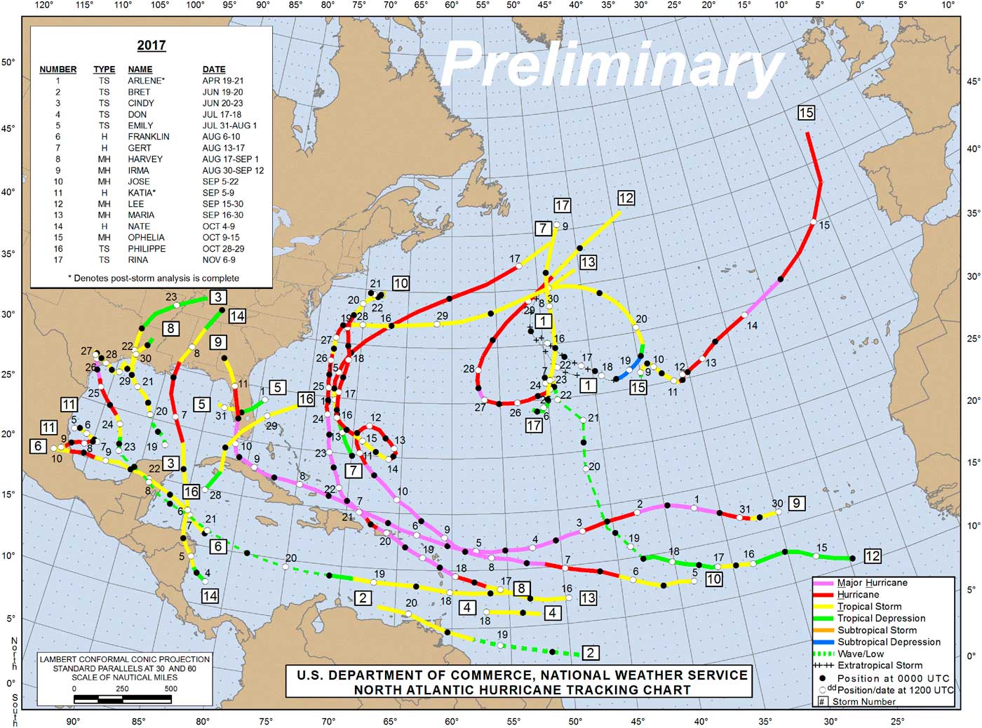
Figure 1 2017 Atlantic Hurricane Season Cyclone Tracks for All 17 Named Storms
Among the 17 named storms in 2017, 7 had their highest wind velocities in the tropical storm range, whereas the other 10 storms attained hurricane wind speeds. Six hurricanes reached major hurricane status, with winds in excess of 110 mph.
We analyzed the National Hurricane Center (NHC) 2017 storm archive files, examining the map sequences to identify the SIDS that experienced tropical storm and/or hurricane wind fields during the passage of each storm. 4 For each Atlantic basin named storm, the archive contains a series of maps, updated every 6 hours, displaying the path of the storm and the geographic center of circulation surrounded by a red oval denoting the area receiving hurricane force winds. The red oval was encircled, in turn, by a larger orange oval, showing the areal extent of tropical storm winds. For those frames displaying a system at tropical storm strength, but below hurricane strength, only an orange oval was visible on the map. We consulted the corresponding series of time-dated storm advisories to estimate the highest wind speeds for each storm’s closest encounter with each of the impacted SIDS.
Table 2 provides an alphabetical enumeration of the 16 UN-member Caribbean SIDS (Table 2a) and the 13 non-UN-member Caribbean SIDS (Table 2b) in relation to the names and intensities of the 2017 storms that interacted with each of these island states. Twenty-two of the 29 SIDS (76%) were affected by at least one storm, and, among these, 4 SIDS were affected by exactly 1 storm, 13 by two storms, and 5 by three storms (Box 1).
Table 2a Small Island Developing States (SIDS) in the Caribbean Region: UN Members 2017 Atlantic Hurricane Basin Tropical Cyclone Impacts and Category at Closest Approach/Landfall

Table 2b Small Island Developing States (SIDS) in the Caribbean Region: Non-UN Members 2017 Atlantic Hurricane Basin Tropical Cyclone Impacts and Category at Closest Approach/Landfall

BOX 1 ∙ Nine of 17 named storms brought tropical storm or hurricane force winds to 1 or more Caribbean Region SIDS.
∙ Twenty-two of 29 Caribbean SIDS were each impacted by 1 to 3 named storms:
∙ Four SIDS were affected by 1 storm, 13 by two storms, 5 by three storms.
∙ For 11 Caribbean SIDS, maximal wind speeds were tropical storm force.
∙ For 11 Caribbean SIDS, maximal wind speeds were major hurricane force.
∙ Nine of 29 Caribbean SIDS experienced direct landfall of a major hurricane.
Eleven SIDS experienced only tropical storm force winds from 1 or several storms and rebounded rapidly without a major effect. In contrast, 11 SIDS were impacted by major hurricane force winds and 9 of these experienced a direct landfall as the eye of the storm came onshore and passed over the island. Major hurricane strikes were crippling for Puerto Rico, Dominica, and many of the island entities throughout the Leeward Islands. For example, Hurricane Irma rendered Barbuda uninhabitable. The eye of Hurricane Maria passed directly across Dominica, splintering the rainforests, destroying staple crops, and leaving houses roofless and in shambles. Puerto Rico and the US Virgin Islands were brought to a standstill by island-wide power outages that continued for months. The combined economic costs for the 2017 storms are likely to exceed those of any previous year (although mainly as a result of damage to the United States rather than to SIDS), with Hurricane Harvey alone projected to be the costliest storm on record. 7 , Reference Drye 8
Table 3 provides a different perspective on the storm track data; here, the 17 storms are listed alphabetically in relation to the SIDS that each storm affected. Nine of the 17 storms brought tropical storm or hurricane winds to at least one of the Caribbean SIDS. Seven of these 9 (Bret, Don, Franklin, Harvey, Jose, Nate, Philippe) brought only tropical storm force winds to SIDS, although 4 of these storms (Franklin, Harvey, Jose, Nate) did attain hurricane strength along portions of their respective trajectories. For example, Harvey briefly brushed the Lesser Antilles as a tropical storm and then dissipated to a tropical wave as it moved westward and crossed Mexico’s Yucatan Peninsula. However, the bedraggled remnants of Harvey rejuvenated in the warm Gulf of Mexico, rapidly intensified to Category 4 strength, and deluged the US mainland, causing catastrophic precipitation and flooding in east Texas and Louisiana.Reference Shultz and Galea 9
Table 3 Seventeen 2017 Atlantic Hurricane Basin Named Tropical Cyclones: Impacts on 29 Caribbean Region Small Island Developing States (SIDS)
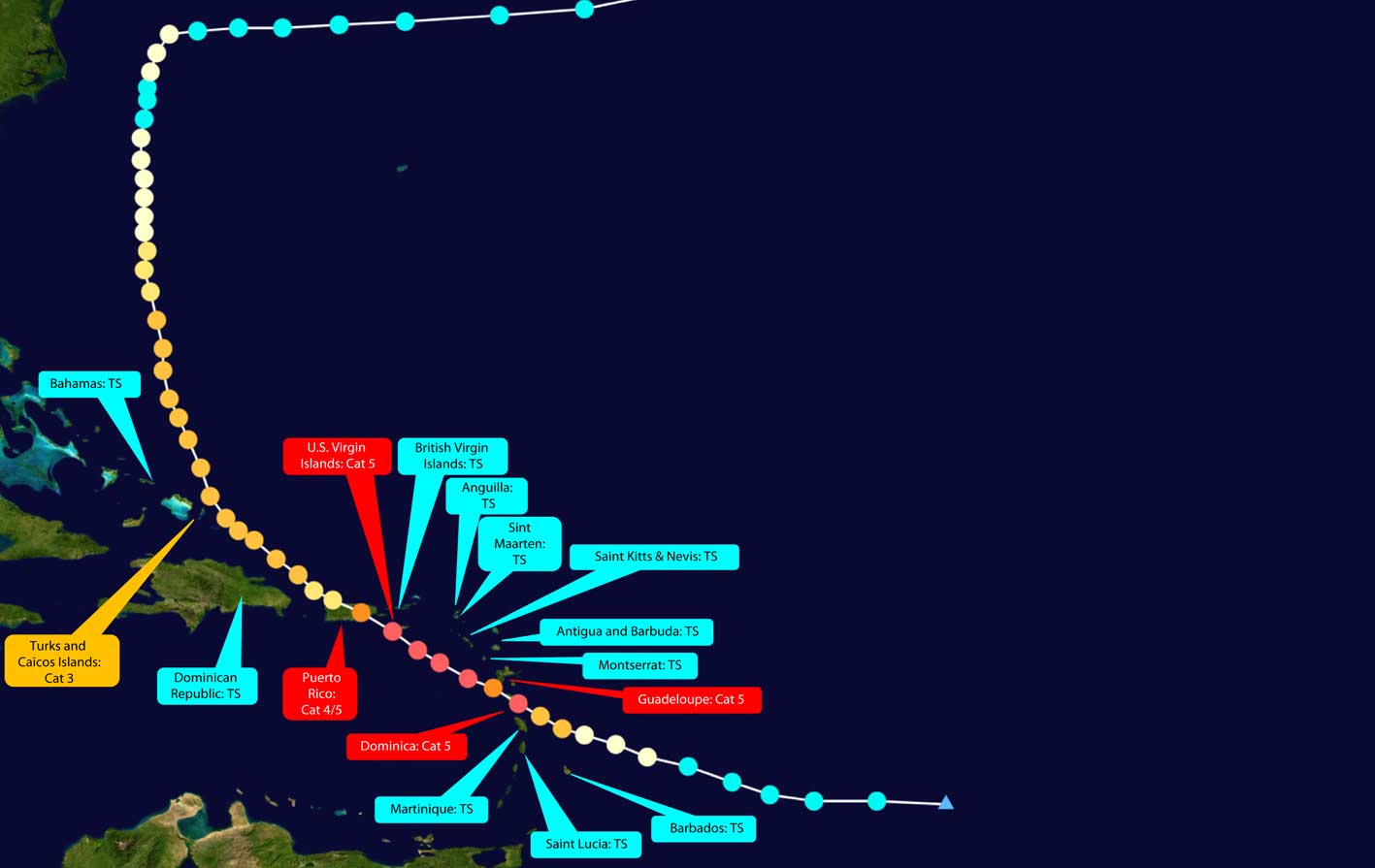
Remarkably, just 2 major hurricanes, Irma and Maria, accounted for all of the 2017 hurricane force impacts on SIDS. Irma and Maria each pummeled a succession of SIDS at tropical storm or hurricane force over multiple days (Table 3, Figure 2, Figure 3). Irma affected a total of 14 SIDS, including 5 at tropical storm force, 1 at Category 1 force, and 8 at major hurricane force. Maria impacted 16 SIDS, 11 at tropical storm force and 5 at major hurricane force. Three SIDS, the US Virgin Islands, Puerto Rico, and Turks and Caicos Islands experienced hurricane velocity winds from both Irma and Maria.

Figure 2 2017 Atlantic Hurricane Season: Hurricane Irma Impacts on 14 Caribbean Region SIDS

Figure 3 2017 Atlantic Hurricane Season: Hurricane Maria Impacts on 16 Caribbean Region SIDS
Climate Drivers and the 2017 Atlantic Storms
Strong hurricanes are statistically rare events, so the highly active 2017 Atlantic season was notable for the number and collective intensity of the 17 named storms. A key metric, accumulated cyclone energy (ACE), provides a summative measure of storm intensity for the entire basin. ACE was the highest on record for the month of September 2017Reference Capucci 10 and seventh overall for the total hurricane season, based on data collected since 1851.Reference Klotzbach and Bell 11
What was observed in 2017 represented a combination of natural climate variability and responses to ongoing anthropogenic forcing in the climate system (eg, sea level rise and a long-term secular trend of increasing ocean temperatures).Reference Myhre, Shindell and Bréon 12 Add to this the lack of an El Niño signal, which tends to suppress Atlantic hurricane activity, and the synergism among these climate drivers contributed to a highly destructive sequence of storms that wrought havoc on the Caribbean SIDS and US mainland.Reference Walsh, McBride and Klotzbach 13 - Reference Shultz and Galea 19 Moreover, the 2017 season may be considered a harbinger of the future, a telltale that the cyclone hazards faced by SIDS are likely to increase in severity (although possibly decrease in frequency) over the remainder of the 21st century.Reference Walsh, McBride and Klotzbach 13 , Reference Knutson, McBride and Chan 14
Two highly salient climate drivers during the 2017 Atlantic hurricane season were anomalously warm ocean water and low vertical wind shear (VWS), which describes the way the winds change with height in the atmosphere.Reference Kossin 17 The ocean temperatures are instrumental in determining how strong a hurricane can become, while the VWS plays a key role in keeping hurricanes from achieving and/or maintaining their potential strength.Reference Kossin 17 The Caribbean SIDS are located in a region where anomalously warm water is naturally concurrent with low shear, creating a highly disadvantageous situation where the potential hurricane strength is high and there is only minimal shear-imposed constraint on reaching or maintaining this potential.
Another salient climate driver during the 2017 Atlantic season was the anomalously great depth to which the warm ocean waters extended. Tropical cyclones are rotating heat engines that derive their immense power from the transfer of warmth from the ocean into the high atmosphere. When there is a deep layer of warm waters, the energy transfer is maintained even as the system churns the sea beneath its canopy of spiraling thunderstorms.Reference Shultz, Russell and Espinel 5
The preceding years, 2014 through 2016, had set 3 consecutive marks for the warmest year on record (based on data collected since 1850) and included one of the strongest observed El Niños, lasting from May 2014 through June 2016.Reference Shultz, Shepherd and Bagrodia 15 The presence of El Niño potentiated vigorous tropical cyclone activity throughout the Pacific basins but concomitantly suppressed Atlantic storm development.Reference Shultz, Shepherd and Bagrodia 15 , Reference Kossin 17 , Reference Jin, Boucharel and Lin 20 The waning of El Niño during late 2016 prompted seasonal forecasters to make prescient predictions for an above-normal 2017 Atlantic basin hurricane season.
Climate drivers have interacted synergistically to make hurricanes stronger in recent years than they were even a few decades ago.Reference Emanuel 16 - Reference Kossin, Olander and Knapp 18 , Reference Emanuel 21 - Reference Reed, Mann and Emanuel 23 Prominent hurricane hazards in 2017 were related to anomalously warm ocean temperatures, which coincide with low VWS in the Caribbean SIDS regionReference Kossin 17 , Reference Coumou, Robinson and Rahmstorf 24 - Reference Rahmstorf and Coumou 26 : (1) the storm season was prolonged, beginning with Tropical Storm Arlene in April, 2 months prior to the start of the official season; (2) the maximum peak wind speeds were elevated due to these high ocean temperatures (eg, Hurricane Irma set an Atlantic basin record with sustained wind speeds in excess of 180 mph for 36 consecutive hours)Reference Shultz and Galea 19 ; (3) most of the storms reached hurricane status; 10 storms in a row, Franklin through Ophelia, became hurricanes, including 6 major hurricanes; (4) rapid intensification prior to landfall characterized the strongest stormsReference Kossin 17 , Reference Jin, Boucharel and Lin 20 ; (5) the atmospheric moisture-holding capacity was elevated due to high air temperatures, leading to increased precipitation rates and torrential rainfall totals (eg, this phenomenon contributed to Hurricane Harvey setting a new US national total rainfall record, in tandem with the storm’s excruciatingly slow track movement)Reference Shultz and Galea 9 ; (6) storm systems remained intact for extended durations, which allowed them to approach and often reach their potential strength; (7) several major hurricanes significantly affected multiple SIDS and mainland human populations along the course of their trajectories (eg, Irma interacted with 14 SIDS prior to traversing the entire Florida peninsula vertically, from the Florida Keys to the Panhandle); (8) storms coming across the Atlantic tracked along similar east-west pathways, leading to repeated strikes on the same human populations; and (9) the 2017 season was consistent with analyses indicating that, “[tropical cyclones] will become stronger, larger, and unexpectedly more destructive under global warming.”Reference Sun, Zhong and Li 27
High-Vulnerability “Disaster Risk Landscape” of Sids
Disaster risk is a function of the interaction of hazards and vulnerabilities. Cyclonic wind and water hazards and their climate drivers have been introduced. Now it is time to ask about the defining vulnerabilities of the SIDS that caused the extremity of harm inflicted by the 2017 storms and thwarted attempts to effectively mitigate and respond to these risks, as follows:
(1) The Caribbean SIDS tropical/subtropical coordinates place them in the ocean corridors where tropical systems form, roam, and strike. The birthing of most Atlantic tropical cyclones occurs within the main development region (MDR), a rectangular geographic area in the tropical Atlantic and Caribbean, extending from west Africa to eastern Mexico (20° W to 85° W longitude) between the latitudes of 10° N and 20° N.Reference Kossin 17 Within this hurricane-spawning swath of ocean real estate, most human settlements are situated on the islands, or clusters of islands, comprising the Caribbean Region SIDS. 1 , 2 Simply stated, SIDS residents inhabit the MDR. As described by Kossin (2017),Reference Kossin 17 the MDR is the region where the dual effect of warm water and low shear primarily occurs. This is very different from the situation along the US east coast, where the shear sets up a natural hurricane gauntlet when the ocean in the SIDS region is warmer than normal.Reference Kossin 17 This is really a very unfortunate aspect of the Atlantic climate system for Caribbean SIDS residents (although it is advantageous for persons living along the US coastline).
(2) As island states, the topography of SIDS features a 360o sea-level coastal perimeter that is vulnerable to wave action and storm surge regardless of the direction of hurricane approach. 1 , 2 Over time, rising sea levels are adding to the wave heights, storm surge volumes, and the coastal and inland areas susceptible to surge and inundation. Sea-level rise also inhibits the ability of flooded inland areas to drain back into the ocean.
(3) Many SIDS communities, especially those that populate coral atolls, have minimal elevation above sea level. During hurricanes, portions of these SIDS are prone to overtopping and prolonged submergence, rendering the storm-affected areas uninhabitable.
(4) Other SIDS owe their formation and rugged verticality to volcanic activity (eg, Dominica is a composite of 9 active volcanoes). The steep terrain is prone to mudslides and flash flooding as copious downpours pummel the island. Illustrating the disaster risk landscape in its most literal sense, as the moist air of the passing tropical system lifts upward over the mountains, it cools with altitude forming orographic clouds that enhance both the precipitation rate and the volume of rainfall within the hurricane’s eyewall and rain bands.
(5) As islands, SIDS are physically remote and geographically disconnected from other land masses. 1 , 2 Therefore, mitigating hazards and responding to cyclone impacts can be more logistically complex than for mainland locales. As a key distinction, mass population evacuation away from storm-threatened coastlines to safer inland locations is not feasible for the smallest SIDS and of limited utility even for larger islands; the size of the swirling cyclone completely dwarfs the dimensions of SIDS entities.Reference Shultz and Galea 19 Satellite images frequently display entire islands completely encircled by just the eye of the hurricane. As a further complication, once the storm has passed through, outside emergency response resources must be flown or ferried to the island, and, as seen repeatedly in 2017, airports and docks may be severely damaged.
(6) Many SIDS are not single islands but a conglomerate of many populated islands (eg, The Bahamas is made up of more than 700 islands with dozens inhabited). The complexity of rescue and relief operations is increased by the need to disperse personnel and dispense materiel to pockets of survivors stranded on multiple islands.
(7) As the acronym implies, most SIDS are geographically small, relatively impoverished, comparatively non-industrialized (developing), and disproportionately challenged to achieve sustainable development. 1 , 2 They have limited natural or manufactured resources (in contrast to several larger developed nations, such as Japan, that are also composed of islands). Understandably, SIDS economies generally cannot appropriate large expenditures for disaster preparedness. Moreover, as evidenced repeatedly in 2017, formidable cyclones easily overwhelm the response capabilities of small islands.
(8) Many SIDS face severe economic constraints related to finite resources, frail infrastructure, inadequate governance structures, and huge inequities in income and resource allocation. 1 , 2 Centralized utilities and public services typically supply the entire island population; if disrupted by a storm, there are no backup or replacement systems available on the island. During the 2017 storms, multiple Caribbean SIDS suffered catastrophic damage to their power grids, bringing the entire island to a halt.
(9) Following decades of UN support and the recognition that, in order to achieve their sustainable development goals, 28 SIDS must develop partnerships among themselves and also with supportive developed nations as outlined in the Small Island Developing States Accelerated Modalities of Action (SAMOA) Pathway. 2 However, prior to the 2017 Atlantic hurricane season – and while still acknowledging the work of CDEMA (Caribbean Disaster Emergency Management Agency), CCCCC (Caribbean Community Climate Change Centre), and each national disaster office – the Caribbean Region SIDS have not made major progress toward forging partnerships for mutual support when disasters strike. 2 Therefore, when so many SIDS experienced calamitous storm encounters in 2017, the Caribbean region was rendered largely dependent upon outside aid.
Cascading Public Health Consequences
The precise nature of human population exposures to hurricane hazards varied by locale, depending upon the storm’s properties at that time and place, coupled with the local vulnerabilities of the peoples and the built environment. Residents of the SIDS territories affected by the 2017 storms faced a range of escalating health threats as they endured the impact phase, and then started rebuilding themselves while waiting for restoration of power, infrastructure, and health services after the storm passed.
Mortality
Tallies of storm-related deaths from tropical cyclones are typically modest in the modern post-satellite era because it is possible to detect large revolving atmospheric systems days in advance and warn the population to seek shelter during the impact phase. More deaths occur in the aftermath and most often from drowning.Reference Shultz, Russell and Espinel 5 , Reference Seil, Spira-Cohen and Marcum 29 With current storm detection technology, recent storm strikes on island-based populations only rarely provide an exception to the generality regarding low mortality rates (one exception: there were 6,300 deaths during 2013 Super Typhoon Haiyan in the Philippines, with many deaths due to the massive storm surge).Reference Ching, Carr de los Reyes and Sucaldito 30 Providing a historical contrast, the Great Hurricane of 1780, the deadliest Atlantic hurricane in history, decimated the Lesser Antilles and Hispaniola, killing an estimated 22-27,000 persons. This storm was also the deadliest tropical cyclone worldwide to strike island-dwelling populations exclusively.
During 2017, the post-disaster conditions on the hardest-hit Caribbean SIDS led to progressively rising death tolls over a period of months as survivors faced prolonged power outages, shortages of basic necessities, and storm-debilitated health care systems. Puerto Rico provides a case in point. Although the official death toll was 58 deaths at 10 weeks after Hurricane Maria swept over the island on September 20, 2017, preliminary studies of excess deaths (compared to previous years) conducted by investigative journalists suggested that the death toll was about 20 times higher at that point and climbing.Reference Robles, Davis, Fink and Almukhtar 31 Carefully designed epidemiologic analyses are needed to estimate the number and rate of preventable deaths, and such studies are now underway in response to public clamor to depoliticize and objectively quantify Maria-related excess mortality.Reference Mazzei 32
A primary contributor to death was the unabated exposure of millions of survivors on the storm-affected SIDS to tropical heat and humidity. It is well known that, without taking preventive action, even moderate temperature elevations are associated with marginal increases in mortality,Reference Wellenius, Eliot and Bush 33 and this is an overlay to surges in deaths from sharp temperature spikes during heat waves.Reference Patz, Frumkin and Holloway 34 - Reference Nordio, Zanobetti and Colicino 40 A variation of this occurred in Puerto Rico and the Leeward Islands where, in actuality, a protracted heat wave occurred by default; the long-duration power outages summarily removed the usual options for staying cool (air conditioning, electric fans). Indeed, vulnerability to heat-related mortality is greater in persons living without air conditioning, and excess cardiovascular and respiratory mortality has been documented in the elderly and persons with pre-existing chronic health conditions.Reference Levy and Patz 41 - Reference Huang, Barnett and Wang 46
Morbidity: Physical Injury
The capability to warn populations to seek shelter as a tropical system approaches minimized the numbers of impact-phase injuries occurring as a result of trauma from projectile debris, broken glass, or crumbling structures. With tropical cyclones, the majority of injuries take place during clean-up and recovery and while navigating the damaged post-storm community environment. Injuries include falls, lacerations (notably chain-saw injuries), puncture wounds, abrasions, fractures, electrocutions, and motorized equipment injuries.Reference Shultz, Russell and Espinel 5 , Reference Ching, Carr de los Reyes and Sucaldito 30 , Reference Kim, Kim and Kim 47 - Reference Brackbill, Caramanica and Maliniak 49
Morbidity: Heat-Related Injury
The 2017 Atlantic season showcased the health effects of a warming planet; SIDS residents were exposed to heat-intensified storms that destroyed the power grids and then, in the aftermath, to life-threatening Caribbean heat and humidity with heat indexes regularly over 37 °C.Reference Coumou, Robinson and Rahmstorf 24 - Reference Rahmstorf and Coumou 26 , Reference Forzieri, Cescatti, Batista e Silva and Feyen 50 This physiological stressor of inescapable heat exposure poses a severe and potentially fatal threat to health and well-being, most acutely experienced by persons with chronic diseases and the elderly.Reference Anderson and Bell 38 - Reference Nordio, Zanobetti and Colicino 40 , Reference Forzieri, Cescatti, Batista e Silva and Feyen 50 - Reference Anderson and Bell 54
Morbidity: Decompensation of Chronic Disease Symptoms
Most storm-affected SIDS experienced major disruptions of health services related to flooded and damaged facilities and aggravated by power outages and fuel shortages. The storms created extraordinary obstacles to the routine management of chronic diseases due to interrupted access to essential medications (eg, for diabetes, hypertension, heart disease) and sites of care (ie, physician offices, clinics, hospitals). Chronic health problems were further exacerbated by unrelieved heat exposure and the inability to refrigerate medications.Reference Benigno, Kleinitz and Calina 55 Even with prioritization, it took SIDS populations weeks to re-establish such lifeline treatments as kidney dialysis and cancer therapies.
Morbidity: Vector-Borne Diseases
Climate influences the distribution and density of vector populations, and the Caribbean is endemic for such mosquito-borne infectious diseases as dengue, Zika, and chikungunya, raising concerns for the spread of known and the emergence of new, infectious diseases.Reference Patz, Frumkin and Holloway 34 , Reference Patz, Grabow and Limaye 35 , Reference Patz, Epstein and Burke 56 - Reference Reiter 60 .
Many SIDS citizens lost their roofs and windows during the 2017 storms allowing insect vectors unimpeded access to occupants who remained in these damaged structures. In addition to the withering heat, many survivors experienced days or weeks of displacement and living partially exposed to the elements without the possibility of protecting themselves from insect bites. While torrential rains washed away some insect eggs and larvae, storm debris allowed standing water to pool, providing optimal breeding conditions for mosquitoes. Based on the post-impact experience following previous extreme weather events, the incidence rates for vector-transmitted diseases are anticipated to increase on the storm-impacted SIDS.Reference Aumentado, Cerro and Olobia 61 , Reference McMichael 62
Morbidity: Diseases Related to Contaminated Water
Disasters propel cascades of emerging infectious disease risks.Reference Patz, Frumkin and Holloway 34 , Reference McMichael 62 , Reference Altizer, Ostfeld and Johnson 63 On several SIDS, the storms triggered island-wide failure of the power grids, which also disabled water treatment and sewage systems. This permitted cross-contamination of the water supply with wastewater containing human feces, urine, and seaborne bacteria. For example, a leptospirosis outbreak investigation was conducted in Puerto Rico several weeks after the passage of Hurricane Maria. Water contamination elevated risks for outbreaks of diseases such as dysentery, E. coli, and typhoid. In Puerto Rico and very likely on other SIDS, water may have been contaminated with chemicals and pollutants from one of the island’s 19 hazardous waste sites.
Morbidity: Mental Health
Although yet to be documented for 2017, the most widespread and debilitating hurricane-related health effects for storm-impacted SIDS residents are likely to be the mental health sequelae.Reference Patz, Frumkin and Holloway 34 , Reference Patz, Grabow and Limaye 35 , Reference Goldman and Galea 64 - Reference Galea, Tracy and Norris 74 Without a viable option to evacuate, millions of SIDS residents were confined to their small islands, unable to avoid direct exposure to the strongest winds and storm surge from the center of the storm, preceded and followed by hours of flooding rainfall.
Psychological distress was almost universally experienced by SIDS residents who experienced tropical cyclone hazards.Reference Shultz, Cela and Marcelin 67 - Reference Lowe, Tracy and Cerdá 70 Direct and inescapable exposure to a potentially deadly threat is a strong risk factor for posttraumatic stress disorder (PTSD).Reference Patz, Frumkin and Holloway 34 , Reference Goldman and Galea 64 - Reference Shultz, Cela and Marcelin 67 , Reference Galea, Nandi and Vlahov 71 , Reference Neria, Nandi and Galea 72 For SIDS receiving major hurricane strikes, the extreme stressors and hardships faced in the aftermath predicted the likely onset of PTSD, depression, or both.Reference Goldman and Galea 64 - Reference Shultz, Cela and Marcelin 67 , Reference Galea, Nandi and Vlahov 71 - Reference Tracy, Norris and Galea 73 Progression to diagnosable psychopathology is likely to be prevalent for perhaps one-third of citizens who were close to the center of a life-threatening major hurricane.Reference Galea, Nandi and Vlahov 71 - Reference Tracy, Norris and Galea 73 Mental health risks are also elevated for special populations such as children, elderly, and persons with medical special needs, including people with disabilities.Reference Patz, Frumkin and Holloway 34 , Reference Goldman and Galea 64 For those with previously diagnosed severe and persistent mental disorders, disruption of routines, as well as barriers to accessing treatment and refilling psychiatric medications, may have led some psychiatric patients to decompensate.
Population Displacement
The sequential hurricanes of 2017 precipitated population movements, including the complete evacuation of Barbuda residents to Antigua; the partial evacuation of St. John and St. Thomas residents to St. Croix following Irma, only to take a direct strike weeks later from Maria; and the much more massive relocation of Puerto Rican residents to the mainland United States.Reference Rechkemmer, O’Connor and Rai 75 - Reference Alvarez 77 Florida is receiving a continuous influx of American citizens from Puerto Rico who are resettling in the continental United States with the high likelihood of remaining stateside.
Daunting Challenges for Mounting Effective Disaster Response
The 2017 hurricane season posed challenges to multiple SIDS that received direct hits from Category 4/5 storms, impacts that far exceeded the local resources and summarily destroyed what response assets existed. Any buffering capacities to absorb the effects of powerful storms were outmatched and overwhelmed. Disaster response challenges for SIDS were complex and multilayered, as described in the following:
(1) It requires resources for SIDS to upgrade building codes, retrofit existing structures to withstand extreme wind speeds and towering surge, build durable high-capacity shelters, and maintain sizeable stockpiles of disaster supplies. Such resources were not made available over past decades, so the extant vulnerabilities were not redressed. Moreover, as ocean temperatures and sea levels rise and storms become progressively stronger, the dangers for SIDS populations will increase, assuming that the current built environment and political priorities remain static.
(2) The standard procedures of staging and prepositioning supplies and personnel nearby, and usually inland from, coastal hurricane impact zones prior to landfall are impractical for SIDS. It is not possible to know precisely which island entities will experience the center of the storm until just hours before impact. In 2017, this was the case for Dominica, which was hit directly by the pinpoint eye of Category 5 Hurricane Maria, leaving the island nation in tatters. Meanwhile, Martinique, the next SIDS to the south, experienced only tropical storm force winds.
(3) Severe damage to the infrastructure, most notably the island power grid, sets off ripples of complications. All forms of civilian communications are hobbled, transportation is brought to a standstill (due to debris-clogged and damaged roadways, fuel shortages, and the inability to pump gasoline without power), schools and most forms of commerce are inoperable, and hospitals must resort to using generators to power a fraction of their most vital services. Emergency response activities can only self-sustain for a finite period before they must be replenished and recovery operations rely on restoration of basic infrastructure, particularly power.
(4) A damaging storm may simultaneously disable all levels of island government, including emergency management response capabilities. The incident management systems, designed to expand upward to accommodate the scale of a disaster, cannot remain functional in a major incident that affects all levels.
(5) Outside assistance will not be timely because resources must be transported to SIDS by air or sea across an expanse of ocean; this requires time and operable airstrips and ports.
(6) For SIDS of even moderate size, plans and mechanisms must be available for transporting basic needs and essential supplies to all affected areas. The inability to deliver supplies to a high proportion of Puerto Rico’s 78 municipalities was one of the most egregious shortcomings of the 2017 response to Hurricane Maria. Although the island territory measures only 100 miles in length by 35 miles in width, residents in the interior waited weeks or months for the establishment of a dependable supply line. The situation was exacerbated by fuel shortages and the debris-strewn condition of the roadways that were blocked by mudslides in some locales.
(7) During active storm seasons, a series of hurricanes may affect populations that are widely dispersed geographically, complicating the logistics of a disaster response. The simultaneous and competing demands from many isolated subpopulations of survivors lead to a multifront, diffuse set of simultaneous responses.
This was certainly the case for the US response to 3 strong 2017 storms: Hurricanes Harvey (Texas and Louisiana), Irma (US Virgin Islands, Florida), and Maria (US Virgin Islands, Puerto Rico). The differential attention and resource allocations provided by lead response agencies, including the Federal Emergency Management Agency (FEMA), to the storm-affected states and territories were notable. The response to Puerto Rico (a Caribbean SIDS that is a self-governing unincorporated territory of the United States under FEMA’s remit) following Hurricane Maria was grossly deficient in both timeliness and effectiveness, particularly when compared to the concurrent emergency operations dedicated to Hurricanes Harvey in Texas and Irma in Florida. In sharp contrast to the continental US emergency operations, the Puerto Rico response was accorded lower priority status, underpowered in terms of personnel, and inadequately funded and resourced.
(8) Response is also hampered by the heterogeneity of SIDS governments. Many SIDS are independent sovereign states, some with historic affiliation to colonizing nations. Other SIDS have not sought or achieved statehood and currently are territories or protectorates of other countries. This creates variability, heterogeneity, duplication, and an inefficiency of response efforts. The northern Leeward Island SIDS include the US Virgin Islands (St. John and St. Thomas were strongly affected by Hurricane Irma and St. Croix that was hit several weeks later by Hurricane Maria), the British Virgin Islands, and a single island that is co-habited by the French collectivity of Saint Martin in the north and by Sint Maarten, Kingdom of the Netherlands, in the south. Nearby is Anguilla, a British Overseas Territory, and the independent Commonwealth of Antigua and Barbuda, a sovereign state. Although these SIDS are in close geographic proximity, and all were severely impacted by Irma, Maria, or both, the disaster response involved a diversity of international partners.
(9) These barriers to mounting an effective response interrelate in complex and compounding ways. What is clear is that the multifront preparedness and response to the impacts of a succession of powerful hurricanes, involving a variety of partners from a range of nations trying to cover multiple jurisdictions simultaneously, have not gone well. None of the SIDS that sustained direct landfalls from a major hurricane (primarily Irma and Maria) successfully regained functionality several months after the storms.
(10) Perhaps most generalizable and pronounced, the realization that was brought home strongly during the 2017 Atlantic hurricane season is that the SIDS are experiencing a crisis created by environmental injustice.Reference Levy and Patz 41 , Reference McKenna 78 , Reference Patz, Gibbs and Foley 79 The contribution of the Caribbean SIDS to climate change is infinitesimally small, yet the climate-driven hazards faced by these island entities are outsized and disproportionate, not helped by internal and external drivers of vulnerabilities that ultimately caused the witnessed hurricane disasters.
Conclusions
In the composite, the 2017 Atlantic hurricanes elucidated the changing disaster risk landscape for human population encounters with weather-related hazards, potentiated by significant climate and vulnerability influences. The 2017 hurricane season demonstrated that disaster risks are not equitably distributed but are much greater for populations with greater vulnerabilities, illustrated by the disproportionate storm consequences sustained by the inhabitants of Caribbean Region SIDS.
Climatological hazards are projected to change rapidly over the remainder of the 21st century as are vulnerabilities to these hazards. Specifically, tropical cyclone risks – exposures of vulnerable human populations to hurricane hazards – are likely to increase due to the lack of adequate action on climate change and on vulnerabilities. As an ironic testament to environmental injustice and to inequity, the populations occupying the SIDS contribute very minimally to the processes that are accelerating the warming of oceans, the rising of seas, the rate and volume of tropical precipitation, and the intensification of cyclones. Yet these very populations bear the highest risks for harm, especially because vulnerabilities are not being properly addressed.