


Introduction
The Graeco-Roman port city of Berenike on Egypt's southern Red Sea coast (Figure 1) was founded by Ptolemy II Philadelphus between 275 and 260 BC (Sidebotham et al. Reference Sidebotham, Hense and Nouwens2008: 135–44 & 151–95; Sidebotham Reference Sidebotham2011). Named after the king's mother, the city is sometimes referred to as Berenike Trogodytika to distinguish it from other cities named after the same queen. It was through this port that Egypt's Ptolemaic rulers imported trade goods as well as the famous war elephants from the southern Red Sea region (Casson Reference Casson1993: 247–60). After its temporary abandonment around the end of the third century BC, Berenike was revived as a commercial port in the late second century BC, and reached its most prosperous phase following Rome's annexation of Egypt in the late first century BC. Berenike became the Roman Empire's southernmost port, and a key trans-shipment point for goods imported from India and other eastern emporia destined for the Mediterranean (Sidebotham Reference Sidebotham2011: 221–58). By the mid sixth century AD, the city was abandoned and never reoccupied.

Figure 1. Map of the Berenike region (figure by J. Harrell using a satellite photograph from Google Earth).
Hellenistic Berenike was a stone-walled, fortified city/base largely built atop a low rocky ridge immediately to the west of what would later become the unfortified Roman port city (Figure 2). Archaeological excavations at Berenike, ongoing since 1994, have exposed the remains of the original Hellenistic site (Woźniak & Rądkowska Reference Woźniak and Rądkowska2014; Woźniak Reference Woźniak2017, Reference Woźniak, Hlouchová, Belohoubková, Honzl and Nováková2019). Near the north-west corner of the fortress, immediately inside a gate through the outer wall, recent excavations have uncovered a well, along with accompanying water-storage and -distribution facilities. This well represents one of—if not the only—source of drinking water for the inhabitants of the fortress. The associated artefacts, along with studies of groundwater levels and bedrock stratigraphy, allow us to reconstruct the history of this third-century BC hydraulic installation through to its failure during a period of climate instability at the end of century.
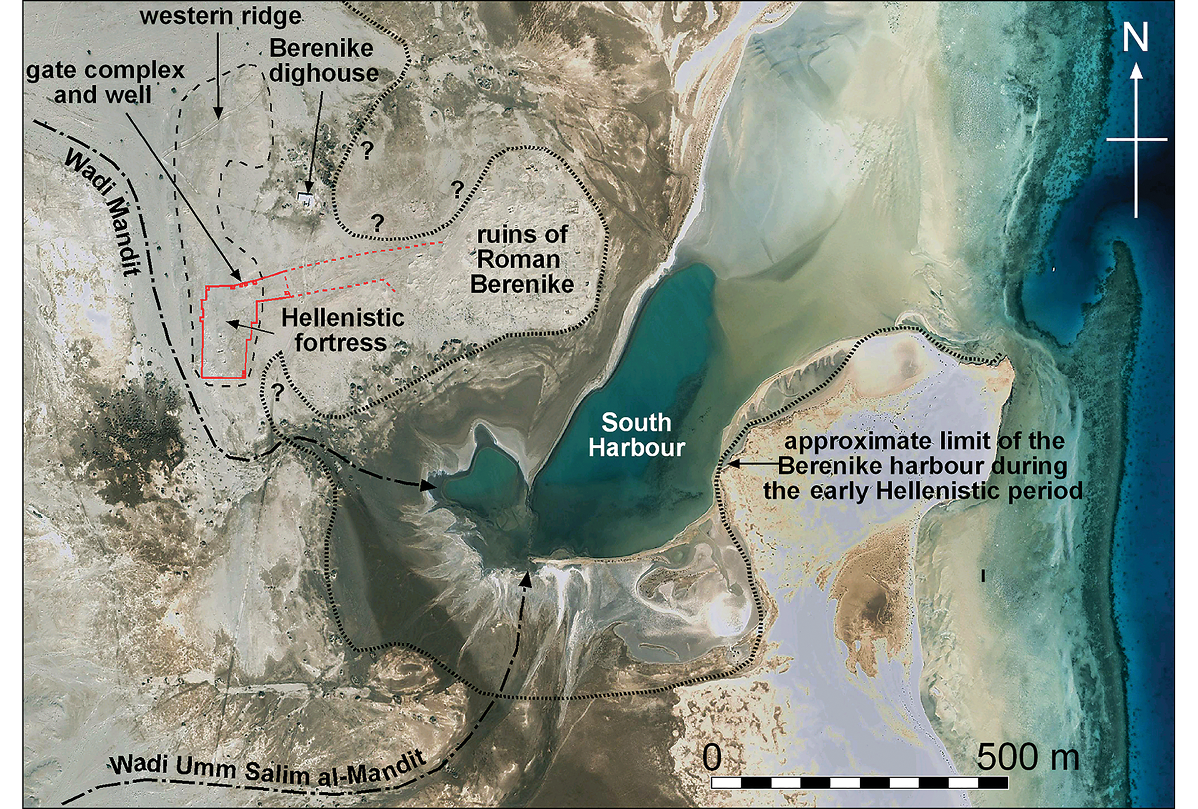
Figure 2. The Berenike site and environs; the fortress walls are dashed where less certain (figure by J. Harrell using a satellite photograph from Google Earth).
As this is the only such structure so far discovered along the Red Sea coast, it allows us to observe, for the first time, how climate can affect the functioning of an ancient settlement in such an extreme environment. It also enables us to explore the relationship between geological and climatic phenomena on the one hand, and economic, logistical and political factors on the other.
Archaeological and geological setting
Berenike is located at the seaward edge of a 6–9km-wide coastal plain on Egypt's southern Red Sea coast (Figure 1). To the west are the Precambrian igneous and metamorphic (crystalline basement) rocks of the Red Sea Hills, and to the north-east is the peninsula of Ras Banas, featuring rugged hills of both crystalline basement and Tertiary sedimentary rocks (Harrell Reference Harrell, Sidebotham and Wendrich1996: 99–103, Reference Harrell, Sidebotham and Wendrich1998: 121–30, Reference Harrell, Sidebotham and Zychin press). Living coral reefs fringe the coast, and just inland from the shore are emergent, Late Pleistocene fossil reefs composed of limestone. The latter date to around 125 000 years ago, when the level of the Red Sea was 6–8m higher than at present (Arvidson et al. Reference Arvidson, Becker, Shanabrook, Luo, Sturchio, Sultan, Lotfy, Mahmood and El Alfy1994: 12 184; Plaziat et al. Reference Plaziat, Baltzer, Choukri, Conchon, Freytet, Orszag-Sperber, Purser, Raguideau and Reyss1995: 18; Pugh & Abualnaja Reference Pugh, Abualnaja, Rasul and Stewart2015: 326). Graeco-Roman Berenike was built atop a small promontory formed by this ‘reef limestone’ (Figures 2–3). This, in turn, rests on sandstone and minor gypsum of the Ranga Formation that dates to the Early Miocene epoch, between 16 and 23 million years ago (Klitzsch et al. Reference Klitzsch, List, Pöhlmann, Handley, Hermina and Meissner1987; Said Reference Said and Said1990: 354). The current climate is hyper-arid, and the occasional winter rains tend to be brief but torrential. Rain runoff flows eastward from the Red Sea Hills across the coastal plain to the coast, both as periodic flash floods and subsurface groundwater that reaches Berenike via Wadi Mandit and Wadi Umm Salim al-Mandit.

Figure 3. Topographic and interpretive stratigraphic cross-section of Berenike, based on excavated trenches and auger cores (drawing by J. Harrell).
The part of the Hellenistic fortress where the water supply and most of the industrial facilities were located occupies the south end of a roughly north–south outcrop of reef limestone (the so-called ‘western ridge’). This outcrop is approximately 800m long and up to 170m wide, with an elevation of 3–3.50m above current mean sea level (amsl) (Figures 2–3). To the east, the residential district of Hellenistic Berenike, and the overlying ruins of the Roman city, are built on the same reef, though here averaging only around 2m amsl. The western ridge represents such a serious obstacle to water flowing down Wadi Mandit that upon reaching Berenike, the water is forced to change from an easterly to a southerly course, whereupon it joins Wadi Umm Salim al-Mandit and enters the lagoon (and ancient harbour) on the south side of Berenike.
The early Hellenistic well
The well of the Hellenistic fortress was uncovered during excavations undertaken between 2014 and 2019 (trenches 97/104 and 125). It is located adjacent to the remains of a gate and tower in the fortress wall (only the lowest part of the western half of which survive), and is associated with the ruins of buildings and structures related to the storage and distribution of water (Figure 4). Coins and pottery recovered from this ‘gate complex’ date to the interval between Berenike's foundation (c. 275–260 BC) and the end of the third century BC. Construction of the gate complex occurred over a short period of time, in two phases (phases one and two), with the latter divided into two sub-phases (sub-phases 2A and 2B).

Figure 4. Plan of the early Hellenistic gate complex on Berenike's western ridge (drawing by S. Popławski based on information from M. Woźniak).
At the heart of the gate complex is a 3.70–3.90m-deep well, cut into the Berenike bedrock. The cut first penetrates through 3–3.30m of a hard, tightly cemented, and hence impermeable, limestone conglomerate with clasts of coarse reef rubble consisting mainly of coral and mollusc fragments. Below this is 0.62m of soft, highly permeable sandstone (grain size <0.25mm) of the Ranga Formation (Figure 3). This sandy interval is a confined aquifer and carries groundwater that likely infiltrates from the overlying alluvium in Wadi Mandit, 120m to the west (Figure 3). The hard bottom of the well is formed by a 20mm-thick layer of selenite gypsum within the Ranga Formation.
In construction phase one the well shaft was roughly square (approximately 1.70–1.80 × 2m). Its original outline is still visible in the deepest part of the enlarged well (‘a’ in Figure 4; also shown as a white outline in Figure 5). During the early part of this later phase (sub-phase 2A), the original well shaft was enlarged into a rectangular chamber measuring 2 × 3.90m, and its top surrounded by thick walls of roughly worked gypsum blocks (‘b’ in Figure 4). Following this (sub-phase 2B), four niches (1.23–1.35m wide × 1–1.40m deep and 1.70m high) were cut into the bedrock at the bottom of the chamber on its north and south sides in order to increase the well's water-storage capacity (the niches on the south side are visible in Figure 5).

Figure 5. Interior of the well in the gate complex looking to the south; the original (phase one) well shaft is outlined. The rest of the chamber, with four niches, represents the phase-two expansion (photograph by J. Rądkowska).
Water was probably taken from the well using a shadouf-type lifting device. This would have comprised a pivoting wooden pole with a rope at one end attached to the lower part of an amphora (serving as a bucket) and a stone counterweight attached at the other end of the pole. A gypsum counterweight was discovered in the well's sandy fill; sherds of early Hellenistic amphorae, which probably served as buckets, were recovered from the bottom of the niches (Figure 6). The buckets were made by cutting off an amphora's neck and handles, and then piercing the rim of the remaining lower section with a row of round holes (about 10mm in diameter) for the attachment points for a rope. The water was probably drawn from the well's north-west corner, as indicated by the flowstone-like gypsum deposits left by evaporating water that ran down the well's wall (Figure 7). The extracted water was stored in basins lined with hydraulic lime plaster: basin two from phase one (‘d’ in Figure 4), and basins one and three from phase two (‘c’ and ‘e’ in Figure 4; also shown in Figure 8). Besides facilitating water storage and distribution, these basins also improved water quality through aeration and by allowing suspended solids to settle.

Figure 6. a) Gypsum counterweight from the well's sand fill; b) fragments of amphora buckets found in the well's south-west niche (scale in (a) is 0.50m; photographs by S.E. Sidebotham).

Figure 7. Accretion ring and top of the aquifer on the well's western wall (photograph by M. Woźniak).

Figure 8. Western part of the gate complex with the well, water-storage basins and related structures, looking to the north (photograph by S.E. Sidebotham).
Approximately 12m to the east of the well, on the other side of an open, courtyard-like space, a square feature (around 5 × 5m) was carved into the reef limestone during phase 2 (‘f’ in Figure 4). Although not yet fully excavated, this feature is clearly a deep water-storage structure—probably a cistern. This is surrounded by massive walls of lightly worked gypsum blocks and coral heads. A complicated network of narrow, open channels (80–180mm wide and 0.20–0.40m deep) for draining rainwater runoff was carved into the bedrock immediately to the north-west of this putative cistern (‘g’ in Figure 4). Around half of these channels brought water into the cistern by passing under its surrounding walls; the rest carried water northward to at least one other basin or cistern that was later destroyed when it was built over, probably in phase 2B. Similar channels led to the well, passing through small openings in its southern and eastern walls. In summary, the well also functioned as a cistern for rainwater runoff, and the addition of this fresh water would serve to ‘sweeten’ the well's otherwise slightly brackish groundwater.
Three more shallow basins were created during phase two in the sandy soil of the courtyard between the well and cistern. These are all of similar size (0.75–1.50m wide, approximately 2.20m long and 0.10m deep: basins two to four at ‘h–j’ in Figure 4) and connect to a drainage channel (2.20m long × 0.35m wide) via a pipe made from cut-off amphorae necks (‘k’ in Figure 4). This channel's destination is unclear, but it probably carried water to the well. This entire installation can be dated (terminus post quem) by the discovery of fragments of two stamped, Rhodian amphorae in the underlying soil. The stamp on one amphora reads ΕΠΙ ΕΥΚΛΕΥΣ (‘Epi Eukleus’) and dates to around 232 BC. The other amphora has stamps on both of its handles: ΕΠΙ ΠΑΥΣΑΝΙΑ (‘Epi Pausania (s))’ and ΚΡΕΟΝΤΟΣ/ΘΕ[Σ]MOΦΟΡΙΟΥ (‘Kreontos/The[s]mophoriou’), and dates to between 233 and 220 BC (J. Lund pers. comm.). Thus, the three basins and drainage channel can be dated to the period shortly after 220 BC.
An increase in Berenike's population in the second half of the third century BC must have placed additional demands on the city's water supply, as would the contemporaneous increase in ship and caravan traffic leaving Berenike, which would have required water supplied from the well. It is evident that the purpose of the phase-two modifications was to augment the site's water supply by increasing the well's storage capacity and capturing rainwater runoff. This may have been a response to a decrease in the well's water level.
The evolution of the well and its associated water-storage facilities coincided with other changes in the gate complex. The original walls on the west side of the gate (‘l’ in Figure 4) were built in phase one using well-cut (ashlar) blocks of gypsum, and were approximately 0.60m thick (‘m’ in Figure 4). During the latter part of phase one, the tower was strengthened by adding a 0.55m-thick ashlar casing around its outer corners (‘n’ in Figure 4). It is not known whether the added casing covered the entire outer surface of the tower, or just its lower part, where it was most vulnerable. During the same period, another low wall (0.40m thick) was built outwards from the tower's reinforced north-west corner to the west, parallel to, but approximately 2m to the north of, the original wall (‘p’ and ‘o’, respectively, in Figure 4). The phase-two reconstruction also included the removal of the eastern half of the gate complex, including a large section of the curtain wall. The gate thus lost its original function, and the space formerly occupied by fortifications was converted to water storage and channels for the capture of rainwater runoff.
Prior to the discovery of the gate complex and its well it seemed certain that the location of Berenike on the shore of the Red Sea—a body of water famous for its high salinity—precluded the possibility of obtaining drinking water from within the Hellenistic fortress itself or from its immediate environs. This supposition seemed to be confirmed by the practice, from the early Roman period onward, of bringing water to Berenike from three fortified hydreumata (a fortified combination of a well and cisterns) located to the north-west (at Siket and Wadi Abu Greiya) and south-west (in Wadi Kalalat) of the city (Figure 1; Sidebotham Reference Sidebotham, Wendrich and Sidebotham1995: 85–93; Sidebotham & Zitterkopf Reference Sidebotham, Zitterkopf, Sidebotham and Wendrich1996: 386–91; Sidebotham et al. Reference Sidebotham, Hense and Nouwens2008: 355–60; Ast & Bagnall Reference Ast and Bagnall2016). The discovery of a well cut into the Berenike bedrock was, therefore, unexpected. This is consistent with the fortified nature of Hellenistic Berenike, where self-sufficiency in basic resources, food and drinking water was deemed necessary. The situation and approach to security, however, was much different for the later Roman city. The Roman army already controlled the entire region surrounding the city, negating the need to maintain defensive walls and allowing the use of distant water sources.
Water levels measured in the well during the 2018 and 2019 excavation seasons remained nearly constant, at about 0.70m amsl. This level did not increase appreciably even after the particularly high rainfall in the 2019 winter season. At the same time, however, the water level in Bir Umm Bela—a well used by the local Bedouin and located in Wadi Mandit, about 0.65km to the north-west of the gate complex—increased by almost 1m (from 1.98m amsl in January 2018 to 2.90m amsl in January 2019). The Umm Bela well is located in an unconfined aquifer that is recharged by rainwater infiltrating directly from the overlying surface. In contrast, the well in the gate complex taps into a confined aquifer, and is therefore less affected by short-term changes in rainfall. Nevertheless, a prolonged wet period will raise the water level, and a sustained drought will lower it. The water in the well is currently slightly brackish but potable. Although not affected by salt-water intrusion from the Red Sea, the well water does receive dissolved salts from sea spray carried inland by winds and from leaching of gypsum beds within the Ranga Formation.
An 80–100mm-thick accretion ring of gypsum-cemented sand, with a spongy tufa-like structure, is visible on the walls of the well's main chamber (Figure 7). This marks the early Hellenistic water level, which was 0.45–0.50m higher than that in January 2019. Its existence indicates that the well's water supply was relatively stable during phase one and the early part of phase two of the gate complex. The ring is more prominent on the well's western wall—the only surviving section of the original phase-one shaft—and less well developed on the other three walls from the phase-two expansion, as these walls were exposed to a stable water level for a shorter period. Within the niches, which date to the later part of phase two, the walls exhibit narrower and fainter accretion rings that were produced by lower and more variable water levels, due to increasing aridity in the Berenike region.
The decline in the well's water level from early Hellenistic to modern times is largely a consequence of the long-term drop in sea level. Following the Mid-Holocene high stand in the Red Sea (around 5000 BC), sea level at Berenike has fallen gradually and continuously until the last century, when climate change reversed the trend (Hein et al. Reference Hein, Fitzgerald, Milne, Bard and Fattovich2011: fig. 3; Lambeck et al. Reference Lambeck, Purcell, Flemming, Vita-Finzi, Alsharekh and Bailey2011: fig. 6). Kotarba-Morley (Reference Kotarba-Morley2015: 189, Reference Kotarba-Morley2017: 81) estimates that the sea level has fallen by 0.85m since the foundation of the port. A hydraulic connection undoubtedly exists along the Red Sea coast between the invasive seawater in the subsurface and the overlying fresh—and hence less dense—groundwater from inland sources. It is therefore expected that the water level in a nearshore well, such as the one in the gate complex, will rise and fall with sea level. Any significant drop in sea level, like the one recorded in the Berenike well, is a slow, centuries-long process. As a result, the rapid decline in the well's water level between construction sub-phases 2A and 2B should be attributed to other causes, such as climate change.
Climate change and the Berenike water supply
The well in the Berenike gate complex ceased to function around the end of the third century BC. Two early Hellenistic bronze coins were recovered from the upper layers of the windblown sand that later filled the well (Figure 9a). These coins came from the Levantine mint at ancient Joppa (modern Jaffa in Israel), as indicated by the harpoon used as a mint mark located to the left of the eagle on the reverse of each coin. This dates the coins to sometime prior to 199 BC, when this mint ceased production (Mørkholm Reference Mørkholm1991: 111), with the reign of Ptolemy IV Philopator (221–205 BC) being the most likely period when the coins were struck. Pottery also found in the sand fill can be broadly dated from the late third to early second centuries BC (Figure 9b). Two other, less well-preserved bronze coins were found in the lowest levels of sand within basins one and two. These can only be dated generally to the early Hellenistic period, but, based on the characteristics of the imagery, were probably minted during the reign of Ptolemy III Euergetes I or IV Philopator. The complete absence of later coins and pottery is a further testament to the rapid infilling of the well and basins after they went out of use.
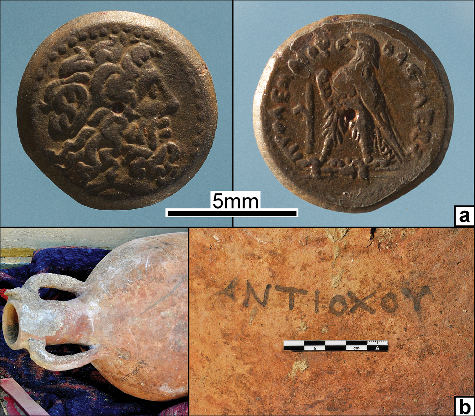
Figure 9. Artefacts from the sand fill in the well: a) an early Hellenistic bronze coin, probably dating to the reign of Ptolemy IV Philopator; b) an amphora; the name on the amphora, Antiochos, is probably that of the owner (photographs by E. Sidebotham).
Abundant wood charcoal from two hearths was found near the bottom of the well: one in the main chamber and one within a niche on top of a 0.50m-thick layer of sand fill (at 0.65m amsl). This suggests that before the aforementioned early Hellenistic coins and amphorae fell into the well, the complex was being used as a shelter. The well had clearly gone dry and had begun to fill with windblown sand when these fires were set at the end of the third century BC or beginning of the second.
A multi-year drought must have occurred to cause the gate complex well to dry up. Such events are a common feature of the Eastern Desert's climate, and can be caused by normal processes, such as periodic changes in the El Niño/La Niña Southern Oscillation in the tropical Pacific Ocean, which have far-reaching climatic effects in north-east Africa. During La Niña episodes (the cold El Niño/La Niña Southern Oscillation phase), the Red Sea Convergence Zone—located between 21 and 16o north—weakens and shifts southward. As a result, the northern Red Sea, including Berenike at 23o55′ north, experiences drought conditions (Dasari et al. Reference Dasari, Langodan, Viswanadhapalli, Vadlamudi, Papadopoulos and Hoteit2018: 762–67).
Another possible cause of a regional drought that could have affected Berenike stems from the climatic effects of volcanic eruptions in the Northern Hemisphere that released large volumes of ash and sulphurous gases into the stratosphere, with the latter condensing into sunlight-reflecting sulphate aerosols (Robock & Mao Reference Robock and Mao1995: 1086; Oman et al. Reference Oman, Robock, Stenchikov and Thordarson2006; Sigl et al. Reference Sigl2015). These aerosols cool the atmosphere, causing either a weakening of or latitudinal shift in climate belts, such as the Intertropical Convergence Zone that controls the summer ‘monsoon’ rainfall in the Nile River's headwaters in the Ethiopian and Ugandan Highlands (Manning et al. Reference Manning, Ludlow, Stine, Boos, Sigl and Marion2017: 3–5). Manning et al. (Reference Manning, Ludlow, Stine, Boos, Sigl and Marion2017) have convincingly shown that a large eruption in 209 BC weakened the Intertropical Convergence Zone sufficiently to cause the summer rains on the Nile headwaters to fail (Figure 10). While this eruption is well documented by evidence in Greenland ice-core data, the volcano responsible has yet to be identified. It was probably, however, one of the four Northern Hemisphere volcanoes known to have had large-volume eruptions at about this time: Popocatépetl in central Mexico, Pelée on the Caribbean island of Martinique, and Yufu-Tsurumi and Hakusan on the Japanese islands of Kyushu and Honshu, respectively (Siebert et al. Reference Siebert, Simkin and Kimberly2010: 323).

Figure 10. Major volcanic eruptions in the Northern Hemisphere between 400 BC and AD 400 (drawing by J. Harrell after Manning et al. Reference Manning, Ludlow, Stine, Boos, Sigl and Marion2017: fig. 1b).
The 209 BC eruption resulted in the failure of the annual Nile flood in Egypt, with the famine that followed, combined with political and social factors, triggering the ‘Great Theban Revolt’ of 207–186 BC (Manning et al. Reference Manning, Ludlow, Stine, Boos, Sigl and Marion2017: 5–6). This disturbance was primed by the discontent of the Egyptian population with its Macedonian overlords, and only required a spark to ignite it. Ptolemy IV Philopator lost control of Upper Egypt for 20 years and with it, access to almost all land routes connecting the Nile Valley with the Red Sea. Berenike thus lost the ability to exchange goods and personnel with the Nile Valley (Sidebotham Reference Sidebotham2011: 41–43; Woźniak Reference Woźniak, Durant, Marchand and Redonin press). This situation is supported by evidence for the temporary abandonment of Berenike by its military garrison in the form of a sterile level in the windblown sand that blanketed the phase-two hydraulic installation in the gate complex. Furthermore, after Ptolemy IV Philopator's reign (221–205 BC), there is a significant decrease in the number of references to the importation and use of elephants in Egypt (Yoyotte & Charvet Reference Yoyotte and Charvet1997: 253; Sidebotham Reference Sidebotham2011: 53). These disruptions at Berenike at the end of the early Hellenistic period probably relate to this revolt. The drying up of the city's well as a probable consequence of the 209 BC eruption constituted a second blow.
Although the exact effects of major volcanic eruptions on the Red Sea Convergence Zone are yet to be established, there is a clear relationship between rainfall in the Red Sea region and distant volcanic eruptions. It has been shown that abnormally cold winters have occurred throughout the Northern Hemisphere for two years following every major tropical volcanic eruption (Robock & Mao Reference Robock and Mao1995; Parker et al. Reference Parker, Wilson, Jones, Christy and Folland1996; Robock Reference Robock2000). This ‘volcanic winter’ scenario is well documented for the Red Sea and broader Middle Eastern region for two recent eruptions: Mexico's El Chichón in 1982, and the Philippine's Pinatubo in 1991 (Genin et al. Reference Genin, Lazar and Brenner1995; Dogar et al. Reference Dogar, Stenchikov, Osipov and Wywan2017; Osipov & Stenchikov Reference Osipov and Stenchikov2017). This phenomenon has severe consequences for the Berenike area, which receives almost all of its rainfall during the winter months. Air-borne moisture, predominantly from evaporation of the Red Sea, is then carried inland by the prevailing winds (Zolina et al. Reference Zolina, Dufour, Gulev and Stenchikov2017). The post-eruption cooling of the Red Sea surface decreases evaporation and, consequently, the winter rainfall in Egypt's Red Sea Hills. Such winter drying over the Red Sea is exacerbated by atmospheric pressure changes over the North Atlantic caused by the eruption, which tend to draw cold, dry north-westerly winds from the polar region across the Middle East (Dogar et al. Reference Dogar, Stenchikov, Osipov and Wywan2017: 7929).
While the climatic effects of a single major volcanic eruption can last up to two years (Robock & Mao Reference Robock and Mao1995: 1099; Dogar et al. Reference Dogar, Stenchikov, Osipov and Wywan2017: 7922 & 7926; Manning et al. Reference Manning, Ludlow, Stine, Boos, Sigl and Marion2017: 3; Osipov & Stenchikov Reference Osipov and Stenchikov2017: 8909), there was another eruption four or five years after the one in 209 BC (Figure 10). The combined effects of these two events could have created a severe drought lasting several years, and it was this that probably caused Berenike's well to dry up at the same time that the Nile flood failed in Egypt.
The phase-2A reconstruction of the gate complex, including enlargement of the well, could have resulted from another volcanically induced climate disturbance. Major Northern Hemisphere eruptions in 247 and 244 BC were indirectly responsible for an Egyptian revolt in 245 BC (Manning et al. Reference Manning, Ludlow, Stine, Boos, Sigl and Marion2017: 6; Figure 10), and may have caused a drought that reduced Berenike's water supply. The famine that preceded this event was caused by a failure of the Nile flood, as described by Marcus Junianus Justinus (Epitoma Historiarum Philippicarum 27.1; Selby Watson Reference Selby Watson1853). The food shortage was so severe that Ptolemy III Euergetes took the unprecedented step of importing grain into Egypt, as mentioned in the Kanopos decree of 238 BC (Hauben Reference Hauben1990: 29–37; McGing Reference McGing1997: 274–77). Distant geological events appear to have disrupted both the fragile climate and socio-political fabric of Hellenistic Egypt, and, in the process, lowered the water level in Berenike's well and ultimately caused this port's temporary abandonment at the end of the third century BC.
Climatic instability due to both global warming and volcanic eruptions is a major concern in the modern world. Berenike's experience provides a good example of how people responded to, and ultimately overcame, adverse climatic episodes in the distant past, yet also provides a sobering lesson on society's vulnerability to geological forces.
Acknowledgements
The authors are grateful to the co-directors of the Berenike Project for their permission to publish this research: Iwona Zych of the Polish Centre of Mediterranean Archaeology at the University of Warsaw, and Steven E. Sidebotham of the Department of History at the University of Delaware. The authors also thank ceramologist J. Lund at Copenhagen's National Museum of Denmark and the peer reviewers.
Funding statement
The first author's archaeological excavations of Hellenistic Berenike were supported by a grant from the Polish National Centre of Science (grant UMO-2015/17/N/HS3/00163).


