


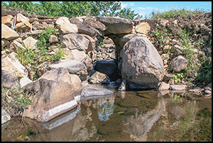
In 2010, Tropical Storm Agatha destroyed a dry-stone bridge that had stood for more than a millennium over a small stream at the ancient city of Cotzumalhuapa in Guatemala (Figure 1). It was described by the noted archaeologist J.E.S. Thompson in 1948, but, surprisingly, it attracted little attention. Rather than highlighting its importance as one of the few pre-Columbian bridges that still stood in Mesoamerica, Thompson himself was uncertain about its dating and entertained the possibility that it had been built in colonial times (Thompson Reference Thompson1948: 38). His qualms were motivated by the presence of a ruined Catholic church in the vicinity, but they also responded to the sheer rarity of bridges in Mesoamerican archaeology.
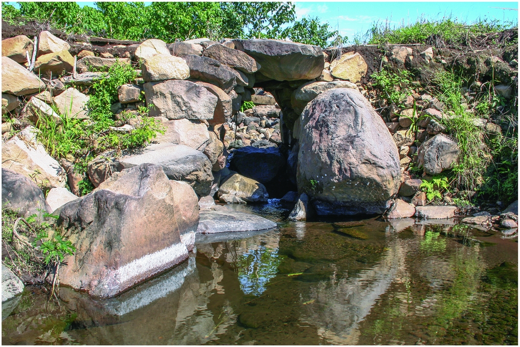
Figure 1. Thompson's bridge. Photograph taken from the south side, during the dry season in 2009, prior to the bridge's destruction (photograph by Oswaldo Chinchilla Mazariegos).
Recent work confirmed that this was one of several bridges built during the Late Classic florescence of Cotzumalhuapa (AD 650–950). The bridges were part of a system of stone-paved causeways that integrated the city's urban core, and extended into its peripheries (Figure 2). The builders of these avenues implemented various solutions to facilitate passage across streams of various sizes throughout the city. While causeways were normal components of ancient Mesoamerican urban plans, the construction of bridges sets Cotzumalhuapa apart from other cities in terms of the development of engineering technologies for urban circulation.
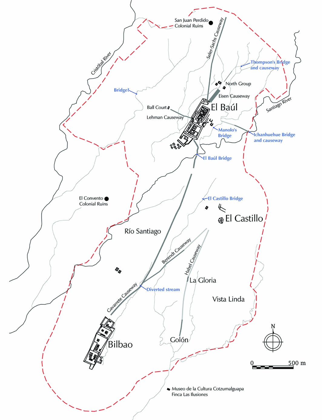
Figure 2. Plan of Cotzumalhuapa with the location of the bridges discussed shown in blue. The red dotted line shows the approximate limits of the Late Classic city. Grey lines correspond to causeways; light grey sections are hypothetical causeway paths (drawing by Oswaldo Chinchilla Mazariegos).
The bridges of Cotzumalhuapa were discovered gradually, and several of them have been described in previous publications (Chinchilla Mazariegos Reference Chinchilla Mazariegos, Laporte and Escobedo1995, Reference Chinchilla Mazariegos, Stuardo and Rock2011; Chinchilla Mazariegos et al. Reference Chinchilla Mazariegos, Zamora, Garay, Neff, Daniels, Arroyo, Páiz and Mejía2012). This article summarises the available data, and offers a characterisation of the bridges according to structural types. It also offers comparisons with bridges reported at other sites in Mesoamerica and elsewhere in the New World.
Bridges in Mesoamerica
Bridges are uncommon features in New World archaeology. The best-known examples are the suspension bridges crafted from entwined fibres that were part of long-distance road systems in the Andes, described with admiration by sixteenth-century Spanish invaders (Gade Reference Gade1972; Bauer Reference Bauer, Isbell and Silverman2006). Andean roads also featured wooden-beam bridges, notably the Huánuco Viejo bridge described by Thompson and Murra (Reference Thompson and Murra1966). The bridges were provided with stone abutments and towers that stabilised the edges of the river gorges, and that provided anchors for ropes or wooden beams. Colonial sources described bridge maintenance work, sometimes done by members of several neighbouring communities. The bridges had custodians who took care of them, helped travellers and collected tolls (Gade Reference Gade1972: 97).
Colonial-period reports generally failed to mention bridges in Mesoamerica. It appears that rivers were generally forded, while small streams were probably traversed on stepping-stones or simple wooden-beam bridges. The only bridges that were described in sixteenth-century texts were those that spanned gaps in the causeways that linked the island city of Mexico with the mainland. Built of wooden beams, they allowed the circulation of water and canoes. Hernán Cortés described a bridge ten-steps wide at the entrance of the city, built of wooden beams that could be removed for defence (Cortés Reference Cortés1970: 56).
There are precious few archaeological indications about the solutions that Mesoamerican peoples devised to move across water courses. Reports occasionally mention the necessity of bridges at specific locations, but the evidence is largely missing (e.g. Hirth Reference Hirth1982: 323). Centuries of exposure to river currents may have easily obliterated traces of bridges, but the dearth of archaeological evidence may also result from insufficient reconnaissance and mapping, and lack of recognition of the remains of bridges.
Despite these problems, bridges have been reported at several lowland Maya sites. Bolles and Folan (Reference Bolles and Folan2001: 306) described what appears to be a small stepping-stone bridge at Calakmul, and more substantial examples are known at Palenque and Pusilha. In his 1785 report on Palenque, Antonio Bernasconi described two bridges, built of stone masonry forming corbelled arches (Castañeda Paganini Reference Castañeda Paganini1948: 41). Recent mapping by Barnhart (Reference Barnhart2001) shows that they facilitated traffic across the mountain streams that flow through the city's densely urbanised core. The modern site map shows no trace of one of Bernasconi's bridges, which stood in the western part of the site, probably over the Picota or Piedras Bolas Rivers, and was about 8 Spanish varas wide (about 6.72m), with a span of 2.5 varas (about 2.1m; Castañeda Paganini Reference Castañeda Paganini1948: 41). The second bridge reported by Bernasconi still stands in the Camp Group sector of Palenque, although it is now reinforced with concrete. It is 10.25m wide, with a span of 1m. In addition, Barnhart (Reference Barnhart2001: 8, 56) and French (Reference French2001: 19, 23, Reference French and Marken2007: 143) reported the pillars of a third bridge, which spanned the Murciélagos River near the Group C monumental plaza group. According to their observations, this bridge had a large corbelled arch with a 2.3m span and a height of 3.5m.
The bridge at Pusilha facilitated urban transit across the Pusilha River, linking the city's main acropolis with the main plaza and the surrounding settlements (Braswell Reference Braswell2007). As described by Gann in 1928, the remains of the bridge consisted of two large stone abutments, separated from the river banks by stone-paved spillways, forming a triple-span bridge (Joyce et al. Reference Joyce, Gann, Gruning and Long1928: 342–43). Braswell suggested that the spillways were built in conjunction with a coffer dam that diverted the water during the construction of the abutments (Braswell Reference Braswell2007: 1). Each abutment was 32 feet wide, extended 75 feet along the river and rose to a height of 15 feet. Gann suggested that they sustained a wooden-beam deck across the 10-yard span of the river, with additional walkways joining the abutments to the river banks. He noted that the bridge would hardly have been necessary during the dry season, when the river was easily fordable, but it became vital when the currents swelled because of seasonal rains (Joyce et al. Reference Joyce, Gann, Gruning and Long1928: 342–43).
Brief mention should also be made of a large masonry heap on the banks of the Usumacinta River at Yaxchilán. Charnay (Reference Charnay1885: 376) recorded a local interpretation of this feature as the abutment of a bridge that ran across this large river. O'Kon (Reference O'Kon1983) reported traces of a second abutment on the opposite bank of the river, and envisioned them supporting a suspension bridge with a span of around 63m. Archaeological observations at the site are inconclusive (Stephen Houston pers. comm.), and the grand scale of the structure casts doubt on O'Kon's hypothetical reconstruction. Nevertheless, the possible remains of bridges at this and other Mesoamerican sites merit further examination.
Judging from the extant examples, bridges in ancient Mesoamerica served as components of streets and causeways in cities, facilitating urban circulation across streams that swelled considerably during the rainy season. They solved practical problems and were also part of ritual pathways or processional avenues within cities. Outside urban contexts, bridges may also have been present in long-distance roads and causeways. In the Palenque hinterlands, Silva de la Mora (Reference Silva de la Mora2008) reported the remains of small bridges along ancient roads, built with stepping stones or walkways of wooden beams now long gone. Further research will probably yield additional examples associated with Lowland Maya causeways.
The bridges of Cotzumalhuapa
The Cotzumalhuapa bridges, as with those of Pusilha and Palenque, facilitated circulation in an urban setting. Cotzumalhuapa was an extensive city, located on the gently sloping terrain of southern Guatemala's volcanic piedmont. It originated in the Middle Preclassic period (c. 600 BC; Parsons Reference Parsons1967), and grew rapidly after AD 650, becoming the largest Late Classic city in southern Guatemala. Recent research shows that the city encompassed the monumental acropolis groups known as Bilbao and El Baúl, and a large open plaza at El Castillo, surrounded by dense residential areas (see Figure 2). The city was renowned for its large and elaborate stone sculptures, carved in a distinctive style that spread throughout much of southern Guatemala (Thompson Reference Thompson1948; Parsons Reference Parsons1969; Chinchilla Mazariegos et al. Reference Chinchilla Mazariegos, Bove, Genovez and Daneels2009; Chinchilla Mazariegos Reference Chinchilla Mazariegos2012).
Early observers mentioned the existence of bridges in the area, possibly relying on reports of local inhabitants. Fuentes y Guzmán drew two bridges in his late seventeenth-century map of the piedmont region near Cotzumalhuapa, without discussing them in more detail (Sáenz de Santa María 1972: volume 2, 46–47). In the late nineteenth century, Eisen mentioned bridges among the antiquities found in the area, but did not describe them (Reference Eisen1888). Until the turn of the twentieth century, the bridges were hidden by dense vegetation that has since disappeared, leaving them exposed to erosion—a loss that explains their rapid disappearance in recent years. The bridges and causeways became a focus point of the Cotzumalhuapa Archaeological Project after reports from a local resident led to the 1997 discovery of cyclopean stone walls on both sides of the Santiago River gorge, south of the El Baúl acropolis (Figure 3).
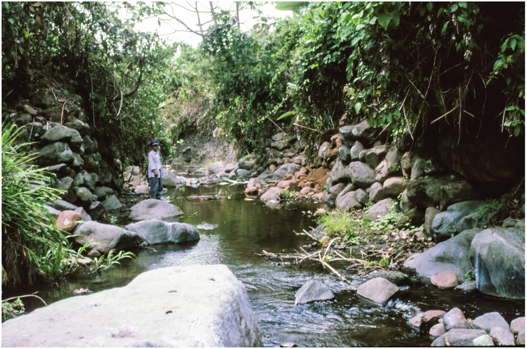
Figure 3. Abutments of the El Baúl bridge. View to the south, taken during the dry season in 1997 (photograph by Oswaldo Chinchilla Mazariegos).
Thick agricultural soils, accumulated from periodic ejecta of the adjacent Fuego volcano, conceal all but the largest architectural groups at the site, making the causeways invisible on the surface. They were identified through a combination of shovel testing, excavation and geophysical prospection (Chinchilla Mazariegos et al. Reference Chinchilla Mazariegos, Castillo, Lipo, Neff, Laporte, Arroyo and Mejía2008; Safi et al. Reference Safi, Chinchilla, Lipo and Neff2012). The causeways were generally 10–14m wide, and paved with finely laid cobblestones, although there are indications that some causeways, or parts of them at least, had tamped earth surfaces. The system remains incompletely mapped, and the remains of bridges provide some of the best clues to the probable location of undocumented causeways.
While orthogonal stone blocks were employed in some buildings at Cotzumalhuapa, the causeways and bridges were built with unmodified or roughly shaped andesite blocks that are locally abundant. The longest causeway extended for 2.5km between the acropolis compounds of El Baúl and Bilbao. Other causeways radiated around El Baúl, and extended into other parts of the city's settlements. The causeways linked elite compounds and public spaces, and reached into outlying sectors of the city. They had ritual meanings and functions, evidenced by the presence of important sculptures and altars along their course (Chinchilla Mazariegos Reference Chinchilla Mazariegos, Stuardo and Rock2011; Cruz Gámez & Chinchilla Mazariegos Reference Cruz Gámez, Chinchilla Mazariegos, Arroyo, Méndez and Ajú2017). They were not, however, designed only for ceremonial and political pageant; they materialised a formal, planned urban layout, integrated the city's components and served practical purposes of circulation for the city's population.
The construction of the causeways involved a substantial amount of land-filling and other landscape modifications. Recent excavations at the Seler-Sachs causeway, which ascends a steep hill north of El Baúl, revealed substantial land-filling upheld by stone-faced terraces that reinforced the hill slope (Cruz Gámez & Chinchilla Mazariegos Reference Cruz Gámez, Chinchilla Mazariegos, Arroyo, Méndez and Ajú2017). Water courses were sometimes modified, as in the case of a small stream near Bilbao, which was diverted to take a sharp angle at the point where the Gavarrete causeway crossed it. The stream was thus made perpendicular to the causeway (Chinchilla Mazariegos Reference Chinchilla Mazariegos, Stuardo and Rock2011: 56; see location in Figure 2). No traces of a bridge were noticed, but it is probable that a wooden-beam bridge facilitated the stream crossing.
Multiple streams traverse the city, generally flowing to the south-west. Most are small, and yet they pose significant obstacles during the rainy season, when monsoon rains cause torrential swelling. The largest waterway in the area is the Santiago River, which flows through a narrow gorge that effectively splits the city, separating El Baúl and its surroundings from the densely settled area around El Castillo. At the city's height, a bridge allowed access to either side of the river near the El Baúl acropolis.
El Baúl bridge
The walls of the El Baúl bridge followed the river course for about 30m, and were preserved to a height of 3m above the dry-season water level (see Figure 3). The walls had an inclination of 16°, which added to their stability. Excavations on both sides of the gorge revealed sections of the Gavarrete causeway, which joined El Baúl with Bilbao. The discovery of the causeway confirmed that these walls served as abutments for a bridge (Chinchilla Mazariegos Reference Chinchilla Mazariegos, Laporte and Escobedo1998). A hypothetical reconstruction that incorporates the inclination of the walls and the causeway pavements suggests that the bridge stood 6.3m above the dry-season water level, and had a span of 9.9m (Figures 4 & 5). The walls probably sustained a wooden-beam walkway, although the possibility of a suspension bridge cannot be dismissed. The causeway was 12.4m wide in the excavated sector, suggesting a similar width for the bridge.

Figure 4. Profile across the El Baúl bridge, including a profile of the excavation that revealed the Gavarrete causeway and monument 69, on the northern side of the river gorge, and an elevated section of the abutment, showing cyclopean masonry (drawing by Oswaldo Chinchilla Mazariegos).

Figure 5. Plan of the El Baúl bridge showing the excavations that revealed sections of the Gavarrete causeway on the northern side of the river gorge (drawing by Oswaldo Chinchilla Mazariegos).
Excavations on the northern side of the gorge revealed that the causeway had two superimposed construction stages, both of which involved substantial modifications of the river gorge. The pavement of the first stage was buried 1.8m below the second stage. The abutments of the bridge served to contain large volumes of artificial fill that raised the edges of the gorge to a convenient height above the stream level. This was confirmed after Tropical Storm Agatha washed away most of the north wall in 2010. The resulting profile shows both construction stages and the combination of earth and stone that was employed to raise the approaches to the bridge (Figure 6). We may speculate that the second stage of construction of the causeway and bridge was added after the earlier one proved insufficient given the level of the river during the rainy season. Ceramic materials indicate that both construction stages dated to the Late Classic period.
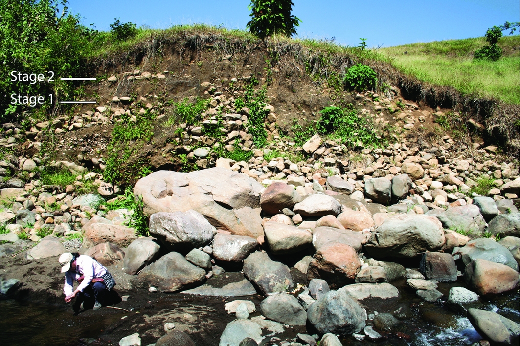
Figure 6. The northern side of the El Baúl bridge in late 2010, after Tropical Storm Agatha washed away the abutment, revealing the artificial fill that was deposited to raise the approach to the bridge. Note the superimposed pavements of construction stages 1 and 2 of the causeway. Blocks from the dislodged cyclopean wall are still visible in the foreground (photograph by Oswaldo Chinchilla Mazariegos).
The approach to the acropolis through the El Baúl bridge was enhanced by monument 69, an enormous sculpture portraying a mythical animal that combined the head of a jaguar with the body of an iguana (Chinchilla Mazariegos Reference Chinchilla Mazariegos2006). The carving stood by the edge of the causeway in its first construction stage, on the northern side of the river, until it was buried under the fill of the second construction stage. Rather than raising it up, the builders of the causeway placed a new monument, monument 54, by the edge of the new pavement. This was a second boulder depicting the same mythical creature, which seems to have been strongly associated with this location. They also added monument 55, which portrayed a standing dignitary (Chinchilla Mazariegos Reference Chinchilla Mazariegos, Stuardo and Rock2011: 60–61). Passers-by were thus confronted by an important array of sculptures as they began the ascent to El Baúl after crossing the bridge.
Ichanhuehue bridge
Built in the same fashion as the El Baúl bridge, the Ichanhuehue bridge also spanned the Santiago River, upstream from the previous one. Reconnaissance in 2010 showed the presence of walls on both sides of the river, which may have served as abutments for a wooden-beam or suspension bridge (Figure 7). The walls were preserved up to 2m high in some places, and extended for about 50m along the course of the river. The length of the walls seems excessive for the abutments of a bridge, and may have also served to help stabilise and raise the river banks.

Figure 7. West abutment of the Ichanhuehue bridge during the dry season in late 2010 (photograph by Oswaldo Chinchilla Mazariegos).
As in the case of the El Baúl bridge, a clue to the function of the walls came from the presence of a causeway, identified by ground-penetrating radar (GPR) prospection conducted by Hector Neff and James T. Daniels in 2011 (see the online supplementary material). In the resulting time-slice graphs, the causeway is marked by parallel linear features that probably correspond to the parapets of a 10m-wide causeway. The causeway does not appear to have a cobblestone pavement in this section, although that and other details should be tested by excavation. The orientation of this segment suggests that the causeway led from the acropolis to the bridge, and presumably continued on the eastern side of the river. The area remains unexplored, except for the ruins of the colonial church of San Francisco Ichanhuehue, located about 1.1km to the north-east. Evidence of Late Classic occupation in this sector is suggested by the casual finding of a carved stone altar by a local resident in the vicinity. Further GPR prospection and excavations on both sides of the river may reveal more details about the causeway and the associated bridge.
Manolo's bridge
This small bridge was built in the same fashion as the larger bridges of El Baúl and Ichanhuehue, but at a reduced scale. The bridge is located on a small stream that flowseast of the El Baúl acropolis, and was named after Manolo Urízar, the project member who reported both this and the Ichanhuehue bridge. Low walls were built on both sides of the current, most probably to sustain a wooden-beam walkway (Figure 8). When documented in 2011, it comprised two rows of large, neatly laid stones laid down like steps on the western side of the stream. The east side had a low wall that combined very large, unshaped blocks with small blocks placed in two or three rows, reaching a height of 1m. It was not possible to determine the original height of the walls. Additional research is necessary to determine whether the bridge was part of a causeway, akin to others at Cotzumalhuapa.

Figure 8. Plan and section of Manolo's bridge (drawing by Alejandro Garay and Oswaldo Chinchilla Mazariegos).
Thompson's bridge
The bridge that Thompson reported was built using the same materials and building methods as the other bridges, but instead of a wooden-beam structure, this was a corbelled arch. Dry stone masonry, combiningcyclopean blocks with smaller ones, was employed to build converging walls on both sides of the stream (see Figure 1). The arch was crowned by three thick slabs that formed a walkway. According to Thompson's measurements, the slabs averaged 0.9m in width and 1.14m in length. The abutments were 7.6m long, and the bridge rose 2.1m above the dry-season water level. The arch was 1.33m wide at the base, and 0.68m wide at the top (Thompson Reference Thompson1948: 38).
Excavations revealed segments of a narrow causeway that led from the North Group plaza-complex to Thompson's bridge (see Figure 2). The cobblestone pavement was only 4m wide, and test excavations at several locations along the course of the causeway suggest that it was discontinuous. The causeway and bridge connected the North Group of El Baúl with a densely settled area on the eastern side of the stream. Further testing is needed to determine whether the causeway continued in that sector.
El Castillo bridge
A different solution was adopted at El Castillo, where a continuous wall was built across the shallow gorge of a small seasonal stream that runs west of the plaza (Chinchilla Mazariegos Reference Chinchilla Mazariegos, Laporte and Escobedo1995). The wall was 2m thick at the base, and rose to a height of 1.7m. A rectangular culvert built at the base allowed the stream to flow through the wall (Figures 9 & 10). The upper surface was 1.3m wide, and extended on the eastern side to form a narrow causeway that ran for a short distance of only 30m towards the plaza. The presence of the causeway bolsters the interpretation of this wall as a bridge, although it may have doubled as a dam. The culvert could have been closed, containing the water of the small stream and thereby creating a small reservoir. Water is abundant at Cotzumalhuapa, and yet residents may still have wished to enjoy the advantage of a reliable water source nearby. The stream is currently waterless during the dry season, but it may have carried more water in the past. In sum, the possibility that this was a dam cannot be discarded, but in any case, the wall did facilitate circulation between both sides of the stream, independent from its potential function as a dam.

Figure 9. El Castillo bridge, north side of the wall during excavation in 1994. The opening of the outlet appears in the foreground (drawing by Oswaldo Chinchilla Mazariegos).

Figure 10. Section of the north elevation and plan of the El Castillo bridge (drawing by Oswaldo Chinchilla Mazariegos).
Excavations revealed a cache deposit at the end of the causeway, which contained a Late Classic cylindrical vase with an obsidian prismatic blade inside. Similar offerings are frequent in Late Classic contexts at Cotzumalhuapa. A carbon sample associated with this cache yielded a calibrated date of AD 679–985 (see Beta-83625 reported in Chinchilla Mazariegos Reference Chinchilla Mazariegos1996: 142–152). Elsewhere, another cache found in the parapet of the Gavarrete Causeway contained a San Juan Plumbate vase, which supported the Late Classic dating of this causeway (Chinchilla Mazariegos et al. Reference Chinchilla Mazariegos, Bove, Genovez and Daneels2009).
Possible bridges
The remains of apparent walls and stone alignments at several locations suggest that there were other bridges at Cotzumalhuapa. One such feature was noted in 2010, in the western part of the city, about 720m west of the El Baúl acropolis. It consisted of an alignment of large stones crossing a small stream and the remains of an abutment on the eastern side (see location in Figure 2). The degree of deterioration made it difficult to determine whether these features were indeed the remnants of a fallen bridge. A small excavation on the eastern side of the stream failed to reveal distinctive traces of a causeway, although its presence cannot be ruled out without more extensive research.
Conclusion
The five bridges described above illustrate three modes of construction: a) wooden-beam or suspension bridges with stone abutments; b) a corbelled-arch bridge; and c) a continuous wall that may have doubled as a bridge and dam. Each alternative responded to specific conditions that included the discharge of the river in the dry and rainy seasons, and the height and span of the bridge. Their construction involved considerable investments of labour and materials, and the approaches to the bridges were modified with large amounts of fill, retention walls and abutments that frequently featured cyclopean stones. All the bridges were built of dry stone masonry, using unmodified andesite blocks that were selected according to shape and size. Roughly shaped blocks were used on occasion.
The bridges were normally built along causeways—some still undocumented—facilitating transit across watercourses of various sizes. Fording the streams was generally possible, but the builders of the causeways opted for solutions that facilitated transit throughout the year, including the periods when rivers rose torrentially due to monsoon rains. All the known bridges are found within the ancient city's densely settled urban core. No bridges or causeways have been identified in the city's hinterlands, but, as in the case of Palenque, long-distance roads may have extended beyond the urban core (Silva de la Mora Reference Silva de la Mora2008).
In addition to New World examples, the Cotzumalhuapa bridges find parallels in Mycenaean bridges from ancient Greece. A shared feature was the use of cyclopean walls, which helped ensure stability. At Cotzumalhuapa, larger stones were commonly employed in the lower tiers, which sustained the weight of the structure while resisting the strength of the swelling currents. Mycenaean bridges employed corbelled arches crowned by flat stones, and their dimensions approximated those of the Cotzumalhuapa bridges, although they were strong enough to sustain wheeled chariots, and were built along long-distance roads (Jansen Reference Jansen2002; Hope Simpson & Hagel Reference Hope Simpson and Hagel2006).
The Cotzumalhuapa bridges are unusual, but the reasons for the rarity of similar structures at most Mesoamerican cities are unclear. The absence of bridges seems at odds with the architectural sophistication of Mesoamerican cities, whose inhabitants would have endured the inconveniences of fording streams of various sizes, sometimes at significant risk during the rainy season. Current evidence confirms that technologies of bridge construction were developed at a small number of cities, notably Palenque, Pusilha and Cotzumalhuapa. At Cotzumalhuapa, the bridges were part of a sustained effort to formalise circulation across the city through the causeway system. It is hoped that the Cotzumalhuapa bridges will provide comparative data for the examination of related features at other sites, so as to understand better the structure of urban landscapes and circulation in ancient Mesoamerica.
Acknowledgements
Research on the Cotzumalhuapa causeways and bridges has been made possible thanks to the institutional support of the Museo Popol Vuh, Universidad Francisco Marroquín and Yale University, and because of grants from the National Geographic Society, the Wenner-Gren Foundation for Anthropological Research and the Panamerican Institute of Geography and History. The sugarcane company Pantaleón S.A. has provided much-needed facilities and logistical support. Geophysical prospection was possible thanks to collaboration with Hector Neff and Carl Lipo, and their students from California State University, Long Beach. I am grateful to Barbara Arroyo, Gilberto Cruz Gámez, Alejandro Garay, Manolo Urízar, Lionel Urízar, Enrique and Rudy Urízar, and the late Lionel Maltés, whose collaboration has, in multiple ways, made this research possible. The final version benefited from comments by Stephen Houston and an anonymous reviewer.
Supplementary material
To view supplementary material for this article, please visit https://doi.org/10.15184/aqy.2017.228


