


Introduction
Angkor Wat (Figure 1) is an icon of World Heritage and one of the world's most intensively visited and studied monuments (Fletcher et al. Reference Fletcher, Evans, Pottier and Rachna2015: 1390 & 1398). Yet in December 2009, a ground-penetrating radar (GPR) survey, extending over an area of 4.3ha (Sonnemann Reference Sonnemann2011: 141), which sought to investigate whether the fourth enclosure at the site was used for residential and administrative purposes (see Stark et al. Reference Stark, Evans, Rachna, Piphal and Carter2015), detected a number of geometrically arranged cruciform features (Figures 2 & 3). Two of these, N1 and S1, are slightly larger than the others and abut the outer porches of the West Gopura (a roofed gateway). Several other groups of features were also found both to the west and east of the entrance gate. Some of these features had been located in the early- to mid-twentieth century, when the Conservation d'Angkor carried out excavations along the causeway and in the vicinity of the West Gopura, exposing a succession of later constructions and parts of the masonry of some of the cruciform structures (Figures 4 & 5).

Figure 1. Overview map of Greater Angkor and the water catchment area, including sites mentioned in this paper; inset top left: regional view; inset bottom left: detail of the central urban area; data courtesy of NASA-SRTM, JICA, Damian Evans and Christophe Pottier.

Figure 2. GPR survey results (iso-surface of major reflections) around the West Gopura, Angkor Wat.

Figure 3. Interpretation of GPR results and numbering of identified structures.

Figure 4. Historical l'École française d'Extrême-Orient (EFEO) photographs of excavations close to the eastern side of the West Gopura (4i—CAM05141, 4ii—CAM05393, 4iii—CAM05395, 4iv—CAM05581; images courtesy of EFEO)

Figure 5. Features identified by EFEO in previous works (based on PLANSCA_0488, PLANSCA_1773, PLANSCA_1781, PLANSCA_1782, PLANSCA_1977a, PLANSCA_1977b and Nafilyan Reference Nafilyan1969: pl. 67).
For over a century, archaeological research on the temple of Angkor Wat has been focused mainly on conservation and architectural surveys, recorded in daily and monthly reports and by photographs and drawings. The Conservation d'Angkor started work at Angkor in 1908, supervised by Jean Commaille, clearing and restoring the monumental main causeway of Angkor Wat. From June 1919–February 1921, Henri Marchal, and occasionally Henri Parmentier, extended the clearance of debris alongside the causeway and around the base of the West Gopura. They removed two mounds that they described as stupa, located two structures (N1 and S1), which Parmentier identified as the bases for wooden additions to the northern and southern porches of the West Gopura, and found several rows of small columns of roughly squared laterite (Parmentier & Marchal Reference Parmentier and Marchal1920). Marchal also unearthed sandstone walls immediately adjacent to the eastern and western faces of the West Gopura. When he unearthed some sections of laterite walls farther east, which were parts of N2 and S2, he assumed that all these structures were later additions to the original temple plan (Marchal 1923). Sometime between the 1920s and 1950s, the laterite pillars on either side of the causeway were removed. During Groslier's landscape work in the 1960s, the masonry foundations of N2 were exposed and documented (Groslier Reference Groslier1967). West of the fourth enclosure wall and south of the moat causeway, the moat steps were restored in the 1960s and again in 2001–2002 by a joint Italian-Cambodian team (Santoro Reference Santoro2005) (Figure 6). Excavations in 2010 and 2012 by the Greater Angkor Project, as a consequence of the GPR survey, have provided additional details on the complex stratigraphy around the buried structures. Layers of fill, occupation debris, masonry working, demolition and natural deposition date between the beginnings of the construction of Angkor Wat in the early twelfth century and its continued use through into the sixteenth and seventeenth centuries and later.

Figure 6. The moat repair in 2003/2004 displays the massive buried clay embankment (image courtesy of Valter Santoro 2005).
Overview
Some of the features recorded by the GPR survey had been noticed by the earlier excavations and identified as structures. These include two laterite structures, unearthed in 1919, 1920 and 1951, situated near the West Gopura porches (N1, S1). The northern one is only partially distinguishable in the GPR survey and may have deteriorated further since its second excavation in 1951. The GPR survey did, however, identify additional elements of features S1, S2, N2 and N3, and additional structures (S3, S4 and N4), making a total of eight cruciform structures and bringing them together as a coherent set. Each is approximately 10m2, with rectangular extensions, akin to porches, on the outer faces, forming a distinctive cruciform plan (Figures 2 & 3). These features are visible to GPR because of remnant laterite masonry and disturbed deposits in trenches where masonry has been removed, and due to the sandstone and laterite rock-chip debris that have subsided into the upper parts of foundation trenches (as can be seen in S4 in Trench Reference Sonnemann, Tjoa-Bonatz, Reinecke and Bonatz2012-2, see Figure 8). The features are interpreted as an inner and an outer set of structures (Sonnemann Reference Sonnemann, Tjoa-Bonatz, Reinecke and Bonatz2012). In this configuration, N3, N4, S3 and S4 form a square, outside of which N2 and S2 are in symmetrical alignment, forming the corners of an outer square symmetrical with the masonry under the western ends of the outer porches of the West Gopura (N5 and S5). The central point of these two concentric squares (N4, N3, S4, S3 and N5, N2, S5, S2) lies directly underneath the first staircase crossway (one of two projecting structures, perron, marked on the map, either side of the causeway and each containing a staircase) on the axis of the main east–west causeway. N1 and S1 are later structures, which postdate the building of the West Gopura, as they abut its north and south porches. They are aligned only with S2 and N2 on the east side of the West Gopura, and were also connected to the perron by the pillared galleries. The construction date of N1 and S1 cannot be, as yet, precisely resolved. They may have been built soon after the West Gopura porches were completed and may have also been associated with the laterite pillar galleries of a somewhat later addition (see Figures 4 & 5).
A symmetrical linear feature about 1m wide (S6 and N6) exists south, east and north of the cruciform structures (Figures 2 & 3) and is perhaps part of a rectangular boundary around the set of structures. There is, however, no trace of an equivalent feature west of the outer wall of the fourth enclosure. A deeply buried linear north–south feature (Figure 6) was found in this area by the Italian-Cambodian team during 2001–2002. Photographs kindly provided by Valter Santoro indicate that this is a thick ridge of clay that may be of some significance.
On the west side of the West Gopura, between it and the west moat, are substantial rectangular structures (N7 and S7), on either side of the walkway leading to the axial porch of the West Gopura. Each of them has a small spur pointing westwards close to the axial pathway. The GPR signal and their layout suggest that these structures are rather different from the others discussed here. They may perhaps be associated with the lines of masonry that were found in the 1920s and 1950s encasing the base of the walls of the West Gopura porches, and that are currently visible on the surface. Closer to the edge of the moat, the GPR data displays a strong signal from two linear features, almost symmetrical, running north (N8) and south (S8) of the main axial causeway. Each feature is located close to the surface and extends for c. 50m due north and south before turning inwards towards the outer gates at the ends of the lateral colonnades flanking the West Gopura. Historical oblique aerial photographs of Angkor Wat, taken by the EFEO, show paths running from the central causeway on the same alignment. Overgrown and not visible to the eye, these paths are the most probable cause for those anomalies.
To assess whether or not the elaborate arrangement of structures by the West Gopura was mirrored by similar structures near the other gopura of the outer wall of the fourth enclosure, additional GPR surveys were carried out at the gopura to the north and to the east of the main temple. The results reveal the remains of small platforms inside the enclosure in front of their porticos, but nothing equivalent to the features discovered next to the West Gopura (Sonnemann Reference Sonnemann, Tjoa-Bonatz, Reinecke and Bonatz2012).
The archaeology of the features identified by the GPR survey
Under specific agreements with the APSARA National Authority (Authority for the Protection and Management of Angkor and the region of Siem Reap), four test locations to the south of the central causeway were excavated by the Greater Angkor Project in order to obtain additional information on the form, stratigraphy and chronology of the various features (Figure 7). Two of these (trenches AWT2010-1 and 2) were laid out in June–July 2010 to investigate S2 and the boundary structure. These were excavated by Dougald O'Reilly, Chhay Rachna, Till Sonnemann, Suy Pov, Noel Tan and Nick Gani. Then followed two small trenches in April 2012 (AWT2012-1 and 2), excavated by Chhay Rachna with Martin Polkinghorne, to assess the relationship of S4 to the West Gopura and the relationship between the boundary structure and the main causeway.

Figure 7. Excavation locations, horizontal and vertical location of trenches (temple elevation based on Nafilyan Reference Nafilyan1969).
The cruciform structures
In 2012, a small 1 × 1.5m test excavation, AWT2012-2, was conducted between feature S4 and the base of the east face of the West Gopura wall. The basal deposit (1) (see Figure 8: i) was sandy with a small clay component and few pieces of rhyolite rubble, and was laid in thick horizontal layers. A variety of deposits such as this, which include some clay layers (see coring referred to in Fletcher et al. Reference Fletcher, Evans, Pottier and Rachna2015: 1394) make up the massive fill of the platform of Angkor Wat and underlie the thick layer of stone chips from the construction work in the central part of the enclosure, found, for example, in the APSARA test excavation for tourist facilities. In AWT2012-2, there are indications in the north-east corner of a deep foundation trench filled with sand and some rock fragments (2), dug into the basal deposit (1) and aligned with the eastern remnant of the rectilinear extension on the west side of S4. At a later date, post holes (3) were dug into and near the area of the earlier foundation trench. They are partially filled by rock-chip debris from the layer (4) that abuts the laterite apron foundation of the gopura wall. The deep foundation trench is therefore part of the construction of the fill of the Angkor Wat platform, and is earlier than the masonry work associated with the building of the West Gopura. When the gopura wall was put in place, the upper part of the western side of structure S4 was removed (cf. the surviving levels of S2 to the east in Figure 8ii). As the upper parts of the cruciform structures were square with porch-like rectangular extensions on each face, the western extension of S4, indicated by the deep east–west foundation trench on the western side of S4, was therefore removed before the construction of the gopura wall began. Feature S4 thus cannot be contemporaneous with the West Gopura wall, nor presumably with the causeway.

Figure 8. Left: trench 2012-2; centre: trench 2010-1; right: trench 2010–2.
The layers of rock chips in trench AWT2012-2 form a distinct pattern that demonstrates the occurrence of two clear phases of masonry work in this area. The first was the lower layer of laterite chips (4) that abuts the laterite foundation blocks, has partially subsided into the deep foundation and substantially fills the upper portion of the postholes. Above that layer and extending farther east is a layer of much coarser sandstone chips (5), as observed in the 1920s excavations, that abuts and buries the very finely finished sandstone foundation blocks of the West Gopura wall. This layer is therefore probably not contemporaneous with the careful, original finish of the West Gopura wall, and must instead indicate a subsequent raising of the ground surface; a later phase of masonry work that is consistent with evidence of substantial later modifications to the West Gopura. The upper part of this layer, sloping up to the top of the base of the West Gopura, had been dug away in 1920. This layer of rock debris is relevant to the stratigraphy in trench AWT2010-1 (Figure 8ii), where its continuation, sloping south-eastward, also appears (layer E) overlying the demolished structure of S2. It contained Chinese ceramics dating from the fifteenth to seventeenth centuries, as well as material dated by 14C to a similar range.
Trench AWT2010-1 (Figure 8ii) was excavated in 2010 at the undisturbed south-east corner of S2, next to the eastern edge of its southern rectilinear extension. The stratigraphy is complex and provides a longer sequence. At the deepest point of the excavation, 1.76m down, the trench exposed the foundations of the south-eastern flank of S2 and the eastern side of its southern rectilinear extension. No intact laterite structure was found, unlike the situation in the north-east corner of this tower where several courses of masonry were unearthed in 1951. The excavation did, however, reveal, in the north-western corner of the trench, alternating horizontal deposits of sandstone chips and sand (A), on top of a deeper layer of pink sand containing small pieces of rhyolite. This construction technique has been encountered in other Angkorian structures; for example, at the Baphuon, the Bayon and Prasat Suor Prat, as a characteristic foundation and the fill for walls (Dumarçay & Royère Reference Dumarçay and Royère2001; Kong Reference Kong and Nakagawa2005; Nakagawa Reference Nakagawa2005). On its eastern edge is a disturbed area (B) (see Figure 8ii) where the masonry that originally faced/or contained the layered foundation has been removed. This trench in part also cut down into the lower deposits. The bottom of the layered foundation cut through a deposit of mixed clayey sand (C) that included some Angkorian-period ceramics in a thin layer of dense, dark clay, interpreted as occupation deposit. The very clayey sand found without any artefacts (D) at the bottom of the trench is the upper part of another 3m of artificial sandy fill with interspersed sandstone chips, revealed through deep coring in and next to the same trench by an APSARA team led by Chhay Rachna (see Fletcher et al. Reference Fletcher, Evans, Pottier and Rachna2015: 1394). S2 was therefore also built after the construction of the Angkor Wat platform commenced.
The 14C dates from the charcoal samples found in this trench (Figure 8, Table 1) place the construction and demolition of the structure prior to the mid-thirteenth century. The earliest date, in the eighth to tenth centuries AD, comes from the layered horizontal fill inside the structure. Consequently, it is high up in the stratigraphy of the deep artificial deposit that forms the massive platform on which the temple of Angkor Wat is built, and is therefore considered to derive from redeposited earlier material incorporated into the foundation layers. Otherwise, on the basis of this one date in clearly redeposited material, we would have to argue that the platform of Angkor Wat was commenced more than two centuries earlier than is currently accepted. Two charcoal samples were collected from within the problematic disturbed area that abuts the southern face of the layered foundation. The lower sample is dated to AD 1040–1210 and the upper one, 0.19m higher, to AD 1160–1260. Due to the disturbance, these two dates have to be taken together, as of now, and we can only state that the construction and demolition of S2 were bracketed by the proposed construction period of Angkor Wat in the twelfth century and the next 50–100 years. Mixed into the layer of rock chips (E)—which thins out eastwards over the top of the demolished foundation of S2—were a large number of finds: sandstone chips, small crystals and Chinese ceramics of the Ming Dynasty (AD 1368–1644), associated with 14C dates from the fifteenth to seventeenth centuries AD. This deposit appears to have formed from a surface on which debris accumulated from the time of the later modifications of the West Gopura dating to the sixteenth to seventeenth centuries AD. A non-conformity in the stratigraphy may therefore exist between the top of the levelled foundations of S2 and the overlying rock-chip layer, as indicated farther south in the eastern section. The pillars, made of laterite blocks, were either built into or on this layer. The surface of the rock-chip layer is sealed by 0.3–0.4m of pale brown, fine-grained, almost sterile material (F), which may represent natural, wind-driven deposition over a period, after the seventeenth century, when the western part of Angkor Wat was only minimally occupied.
Table 1. Radiocarbon dates from trench AWT2010-1, showing periods of activity.

1022: Beta-306432: 2σ calibrated result: (95% probability) cal AD 1460–1640 (cal BP 490–310)
➔ 380±30 BP, or cal AD 1480–1540 (1σ), or cal AD 1460–1640 (2σ)
1024: Beta-306433: 2σ calibrated results: (95% probability) cal AD 1440–1500 (cal BP 510–440) and cal AD 1600–1610 (cal BP 350–340)
➔ 410±30 BP, or cal AD 1440–1470 (1σ) or cal AD 1440–1500 and cal AD 1600–1610 (2σ)
1026: Beta-306434: 2σ calibrated result: (95% probability) cal AD 1490–1660 (cal BP 460–290)
➔ 300±30 BP or cal AD 1520–1580 and AD 1630–1650 (1σ), or cal AD 1490–1660 (2σ)
1028: Beta-306435: 2σ calibrated result: (95% probability) cal AD 1040–1210 (cal BP 920–740)
➔ 920±30 BP or cal AD 1050–1090, AD 1130–1140, and 1140–1170 (1σ), or cal AD 1040–1210 (2σ)
1028: Beta-306436: 2σ calibrated result: (95% probability) cal AD 1160–1260 (cal BP 800–700)
➔ 860±30 BP or cal AD 1170–1220 (1σ), or cal AD 1160–1260 (2σ)
1029: Beta-306437: 2σ calibrated result: (95% probability) cal AD 780–980 (cal BP 1160–970)
➔ 1210 ± 30 BP or cal AD 880–900, AD 920–950 (1σ), or cal AD 780–980 (2σ)
The boundary structures
Trench AWT2010-2 (B) (Figure 8iii) overlapped the GPR trace of boundary feature S6, 15m to the east of trench AWT2012-1. In this area, the GPR appears to be picking up the fragmentary debris and isolated blocks of a disturbed and obscure feature, perhaps a robber trench from which masonry has been removed along the edge of a low platform or terrace. Low down in the section, on the line of the linear GPR feature, two thin, alternating layers of sand and sandstone chips were exposed, indicating a foundation trench. Blocks of laterite (a) (0.3–0.5m long and wide, 0.1–0.2m thick) were piled chaotically in this area and covered by laterite gravel. The remnants of the feature were buried by irregular layers of sandstone chips (b) similar to those covering S2 and containing tiny fragments of brick. Farther north, close to the wall of the causeway where the boundary feature is not visible to GPR, AWT2012-1 (C) (see Figure 8iv) was excavated to identify whether the boundary had been removed when the causeway was built. At the level where the feature should exist above the basal clayey sand, there is only a thin scatter of comminuted laterite fragments (i). Above this level are two layers of sandstone chips separated by a layer of reddish clayey sand (ii). No trace of the boundary feature remains, suggesting that it was removed when the axial causeway was built and that the layers of sandstone chips are the debris from finishing the blocks of the causeway and the carving of the mouldings, balusters and naga. As with S2 and S4, the boundary structure was founded after the basal sand of the Angkor Wat platform. As with S4 in relation to the West Gopura, it does not display any evidence of contemporaneity with, or juxtaposition to, the main causeway, and may have preceded its completion.
Appraisal
The scale and position of the eight, now buried cruciform structures has no precedent within the main enclosure of any other temple. The specific form of the West Gopura and its associated gates is also unusual but not unique, as it has a precedent in the Baphuon's East Gopura; variants occur later (e.g. at Preah Khan). What complicates the assessment of these features is a complex succession of additions and alterations, some of which have been removed or were built over the top of earlier structures. The structures have been demolished and removed to differing degrees and have varied chronological associations to each other, to the West Gopura and the main causeway. They appear to have broadly similar shapes and display a contiguity of layout. The structures were built on deep foundations in the basal sand of the artificial platform on which the temple of Angkor Wat is built. Above this, the body of structure S2 displays alternating layers of sand and rock chips, held in place by laterite walls to form a raised platform—a typical feature of the foundations of substantial Angkorian buildings. The laterite walls are apparent in all the cruciform structures.
These structures resemble shrine towers in plan, with short porches facing in all four directions. These occur in other temples of the eleventh to twelfth centuries (Figure 9i). Boisselier identified this tower plan as a feature that appeared in Ta Keo in the late-tenth to early eleventh centuries (Reference Boisselier1966: 63). The same pattern of four short porches can be seen on all the corner towers of the main temple of Angkor Wat, even though two of the porches of each tower are embedded in galleries (Figure 10). An Angkorian shrine tower of the twelfth century was built with a sand core with a laterite casing (as seen in S2) but was usually also clad in sandstone as the decorative surface (Figure 9ii). No fragments from the demolition of sandstone masonry have, however, been found either in the excavation of the cruciform structures or scattered around the area. The rock-chip debris is from the initial chiselling down of newly emplaced blocks on other buildings during construction. It is not debris from demolition. The absence of any broken, finished sandstone blocks might mean comprehensive demolition and reuse (there are major constructions close by to which the blocks could be relocated), or it may indicate that the structures were never completed with a sandstone facing. This is at odds with the long-term effect of the cruciform structures on the configuration of other features in the area, which suggest that some of them, at least, continued to be visible until the laterite pillar galleries were built. It is also possible that the superstructures were built of timber, which would have been unusual. While timber was used in Angkorian temples (Parmentier Reference Parmentier1935; Dumarçay & Royère Reference Dumarçay and Royère2001: 11; Cunin Reference Cunin and Clark2007; Uchida et al. Reference Uchida, Cunin, Shimoda, Takubo and Nakagawa2008), the problem in this case is to specify what empirical evidence would allow us to identify an entire ritual building made of timber that had been completely removed. The other option is that these were pavilions containing small, pillared halls, as indicated by the form of S1 and N1. This arrangement would not be unique in twelfth- century Angkor Wat, where a four-pillar version in stone exists in the ‘libraries’ (L1 and L2) of the second enclosure (Figure 10f). But the latter buildings are rectangular rooms and do not have four matching porches. The empirical problem with this option is that timber pavilions would have had tiled roofs. These produce quantities of broken tile absent from the excavations, although this may have been swept away after demolition. Furthermore, a four-pillar pavilion format, especially if present on the central square platforms of all the cruciform structures, is more akin to the predominantly timber-made ritual structures associated with Therevada Buddhism in the fourteenth to sixteenth centuries than the shrine tower form of the twelfth century. The laterite pillars over S3 and N3, for example, may either be an earlier twelfth-century ‘tower’ form that has been demolished down to the supporting platform and replaced by a pillared pavilion, or a demolished structure buried under a pillared gallery or pavilion built in the early twelfth or the fourteenth to sixteenth centuries. What form of building the cruciform structures carried is not known, nor whether they were all the same. Consequently, they can only be referred to in qualified terms as ‘towers’.

Figure 9. Plan of tower of an Angkorian shrine and section through wall of an Angkorian structure—one of the ‘libraries’ of the Bayon (image courtesy of JASA).

Figure 10. Comparison of cruciform structures of Angkor: a) Phnom Bakheng, early tenth century; b) pre-Rup, mid-tenth century; c) east Mebon, mid-tenth century; d) Takeo, late-tenth to early eleventh centuries; e) cruciform tower bases at G4W—schematic; f) Angkor Wat (source: a–d: Glaize Reference Glaize1944; f: Pottier Reference Peri1993: pl. 40).
What they were is significant due to the various configurations and successive arrangements of which they may have been part. The key issue is that some of the ‘towers’ were part of a group of structures that were built after the foundation platform of Angkor Wat was constructed, and were demolished before the completion of the steps that form the east face of the west moat, the West Gopura, the wall of the fourth enclosure and the main causeway. Hence, some of them were contemporaneous with the construction of the central main temple and were removed before the final construction of the axial causeway and the perimeter structures. The unresolved questions are: what they were for, how many of the cruciform structures formed what kinds of configurations over time and when was each ‘tower’ demolished? That the set of structures was a ‘model’ for Angkor Wat does not seem probable as the configuration is not the same and the towers had carefully constructed foundations that suggest that they were intended to be a functioning building. As well as the contemporaneity of some of the structures with the construction period, what is also revealed in the story of the ‘towers’ is some element of long-term continuity. These structures are, therefore, of profound significance for our understanding both of the procedure involved in building Angkor Wat and of the continuities of practice inherent to its use from the twelfth century onwards. The absence of the ‘towers’ from a Tokugawa-period map of Angkor Wat (Peri Reference Pottier1923), based on the reports of a Japanese pilgrim, suggests that the structures had disappeared by the early- to mid-seventeenth century. If a strict and exclusive symmetry is invoked for the relationship between the structures, then a very substantial quincunx of ‘towers’ was located axially on the western edge of the Angkor Wat construction site, with considerable implications (Figure 11). Whether this configuration was then demolished in a single event when the West Gopura and main causeway were built, or whether the ‘towers’ were successively demolished and combined with new structures (added over the following centuries), is not, as yet, assessable. If we consider looser symmetries, a variety of layouts and alternative combinations of new and old structures of varying dates are possible. The two main symmetry alternatives will be summarised below without seeking here to review the numerous alternative developments that might have occurred. Further excavation of each of the structures is needed to resolve the options.

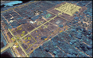
Figure 11. Overview of Angkor Wat showing relationship between the buried ‘towers’ and the position of the main Angkor Wat temple (by Sonnemann and image base courtesy of ETH Zurich).
Separating out N7 and S7 on the grounds that they are unlike the other rectangular features and have a different relationship to the walls of the West Gopura, the strictly symmetrical configuration incorporates features N2-5 and S2-5. Note that this model requires that the two outer porches of the West Gopura are each built on top of a structure of the same form as N2-4 and S2-4. To complete the symmetry, a central cruciform structure would also be required, now buried under the main causeway. This would, however, have been big enough for its projecting porches to extend beyond the line of the causeway just to the east of the first stairway (perron) of the causeway. Although little probably remains of the structure, there is an angled fragment of masonry consistent with such a feature, located next to the east wall of the southern stairway (see Figure 5). The strict symmetry model produces a quincunx configuration of two concentric groups of four ‘towers’, surrounding a central ‘tower’. The central part of Angkor Wat takes this form but is much larger. The buried ‘towers’ are, however, almost the same size as the towers of the second enclosure. The quincunx configuration is known from the ninth century at Phnom Bakheng (AD 889–923) (Figure 10) and in other Angkorian temples (Boisselier Reference Boisselier1966: 53), both on pyramids, as at the east Mebon (Stern Reference Stern1933), built between AD 944 and 968 and on low platforms at Pre Chema Sram. The latter arrangement is rare. None of the buried ‘towers’ was raised on a high platform, so this configuration, as used in the western quincunx, was rather unusual. Whether this ensemble was a shrine used while the main temple was being built is an intriguing and, as yet, unassessible proposition.
When the West Gopura and the causeway were built, the buried ‘towers’ were removed either entirely or in part. Only S4 and N4 are actually overlapped by structures integral to the West Gopura and would have had to have been removed. The hypothetical N5 and S5, and the central ‘tower’, would also have been removed. N1 and S1 were added later. S2 and N2 could have persisted through to the fifteenth century according to the stratigraphy over S2, in a symmetrical relationship with N1 and S1 (Figure 3), which are not, however, symmetrical with N4 and S4. Strict symmetry would also have included a continuous boundary feature with a western edge, of which no trace is apparent. This scenario directs attention to the issue of how much substantial engineering work was required to emplace the steps around the moat and construct their foundations. The date of the large clay ridge (Figure 6) behind the moat steps becomes critical for future inquiry. If it could be shown to be of the same date as the West Gopura, then its preparation would have sufficed to remove the boundary feature on the west side of the ‘towers’.
The second scenario allows that N4 and S4 and any combination of other ‘towers’ were in use or built at the same time, with the proviso that N1 and S1 were built after N4 and S4 had been demolished. In this configuration, for example, N1 and S1 might have been arranged, with N2-3 and S2-3, to form two symmetrical groups of three ‘towers’ on either side of the causeway. Alternatively, they may have been in a simple axial symmetry with S2 and N2 aligned on the outer porches of the West Gopura and on the nearby libraries to the east. How the pillar galleries then related to S2-3 and N2-3 is unclear but continuity of association through several transformations is indicated by the pillars on top of S3 and N3, and by the way the pillar galleries skirt around S2 and N2 (Figures 4 & 5). This more varied scenario raises the possibility that the boundary feature was only associated with a continuing use of some of the ‘towers’, after the West Gopura and the fourth enclosure had been completed. In this case, no western portion of the boundary feature would ever have existed. The difficulty with this proposal is that there are no abutment traces where the boundary feature meets either the north and south faces of the main causeway or the east face of the western wall of the fourth enclosure north and south of the West Gopura. The boundary feature is therefore probably part of an earlier configuration as much as a later one, opening the possibility that in due course, as mentioned earlier, alterations to the moat edge may explain the curious absence of the west side of a bounded area around the quincunx of ‘towers’.
Conclusions
Angkor Wat has been a topic of research for over a century but can still yield surprising new results to archaeological inquiry. As well as demonstrating the potential of archaeology, in contrast to history, and the power of new investigative technologies, the GPR survey of the buried ‘towers’ also shows how these analyses can transform the significance and understanding of the results of earlier research. This study emphasises the obvious but easily forgotten point that a great and famous place is not sufficiently known just because we have seen it many times. Nor is what we can see on the surface sufficient for us to understand how the monument became what it is. The pattern of the ‘towers’ and the structures around them demonstrates both change and continuity in the layout of Angkor Wat, from its inception in the twelfth century through to at least the early seventeenth century. In addition to unravelling the complex structural history of the ‘towers’, new questions need to be asked about the inauguration of Angkorian temples. The configuration of the buried ‘towers’ contains the unique possibility that a shrine was built on the western side of the Angkor Wat platform during the period when the main temple was being constructed.
Acknowledgements
Our special thanks are extended to the APSARA Authority for permission to undertake field investigations in the fourth enclosure of Angkor Wat, including HE Bun Narith, HE Ros Borath and An Sopheap, who helped expedite the fieldwork. ARC grant DP1092663 supported the work described in this paper. Thanks also go to the Greater Angkor Project 2010 and 2012 crew members who facilitated the research presented in this paper; Miriam Stark (University of Hawai‘i, Manoa), Li Baoping (University of Sydney), Noel Hidalgo (Australian National University) and Shawn Szejda Fehrenbach (University of Hawai‘i, Manoa); Suy Pov and Hen Chenda; and the staff of the Robert Christie Research Centre, especially So Malay in Siem Reap and Martin King in Sydney, l'École Française d'Extrême-Orient and the APSARA Authority in Siem Reap, Cambodia.


