

INTRODUCTIONFootnote 1
Karpathos is one of a dozen islands collectively known as the Dodecanese. The first-century ad geographer, Strabo, reported that the island was home to a tetrapolis in the Classical and Hellenistic periods (10.5.17). The sites of three cities have been identified at Pigadia, Arkassa and Vrykous (Fraser and Bean Reference Fraser and Bean1954, 141–4; Moutsopoulos Reference Moutsopoulos1975–7, 123–6) (Fig. 1). The location of the fourth city remains unknown. In 1923 Gilbert Bagnani (Appendix II), then a young student at the Italian School, conducted exploratory excavations and identified limestone blocks with cuttings characteristic of Hellenistic temple architecture at Leukos, located on the west coast of Karpathos, and subsequently proposed that it was the site of Strabo's fourth city (Bagnani unpublished [1923]). His suggestion inspired the Leukos Survey Project, which was the first comprehensive archaeological survey of the area, and its results are the subject of this article. Fieldwork undertaken from 2008 to 2011 systematically surveyed all visible ancient remains using topographic and architectural mapping, intensive surface artefact collection, satellite remote sensing, and low-altitude aerial photography. The project goals were twofold: to establish the settlement's chronological parameters, in terms of the nature and rate of its growth; and to map the settlement's urban fabric with a view to reconstructing its development. In the end, the fieldwork could not confirm Bagnani's assertion, but it established the existence of a fifth- to sixth-century ad port settlement clustered around three natural harbours (Fig. 2).

Fig. 1. Map of Karpathos with sites mentioned in the text.

Fig. 2. Topographic map of Leukos with survey area shaded.
Leukos' role or participation in maritime trade or shipping became a particular point of interest for the survey because of five notable geographical and environmental features of the site. First, the settlement was coastal, with some of its most prominent buildings constructed right on the shoreline. Second, it had three natural bays, two of which were sandy and naturally protected. Third, Leukos' location on the west coast of the island, and its setting within the broader Mediterranean, made it an obvious stepping stone or port of call along the sea lane between Crete and Rhodes. It also held an interim position on a cross route from the ports of North Africa and those of the northern Aegean, particularly of Constantinople. By the time the settlement at Leukos reached its largest size, shipping traffic in the Mediterranean, and especially along the grain route that supplied the capital of Constantinople, was flourishing. Fourth, the toponym, Leukos, perhaps refers to the colour of the bare, sun-bleached limestone cliffs which face the sea, marking the edge of the settlement on its north side. Such prominent geographical features were used as navigational markers for ancient and medieval mariners (Morton Reference Morton2001, 189–90). Finally, the area of Leukos has very little arable land, which can be said for the entire island, and the settlement may have depended on sea traffic for its survival. With seaborne trade and shipping in mind, the project also sought to identify material cultural connections with other settlements on the island and, beyond its shores, with other Mediterranean communities.
The topography of Leukos
Karpathos is a rugged and mountainous island. The Karpathos mountain range dominates the topography and forms a high and precipitous central spine along the length of the island. Its highest peak, at Kali Limni in the centre of the island, rises to 1215 m. At the extreme northern and southern tips of the island the topography is more gentle; however, year-round winds plague these lowlands, making them unsuitable for any sort of prolonged settlement activity (for ‘windy Karpathos', Κάρπαθος ἠνεμόεσσα, see Homeric Hymn to Delian Apollo 1.43). Along the eastern coast, the mountain range drops sharply down to the sea, allowing only for small narrow coastal plains in the area of the modern port city of Pigadia and around the shores of the Pigadian Bay. The topography of the western side of the island is similar, though occasionally the descents from the mountain peaks become more gradual and give way to narrow coastal plains. Leukos occupies one of these plains, which is located about one third of the way up the island's west coast. Steep foothills and ridges of the Karpathos range border the entire plain at its northern, eastern and southern edges. The plain measures about 3.4 km2 in area and is roughly oval in shape, with its long axis aligned north–south. Today it is largely barren and supports only some meagre hay fields. Sometime prior to the establishment of the settlement, tectonic activity caused a portion of the plain to drop dramatically in elevation by approximately 32 m. As a result, the topography can be divided into three distinct areas: (1) the settlement plain, which is closest to the shoreline and includes the three natural harbours and the two prominent peninsulae; (2) the upper plain; and (3) the steep ridge that separates them (Fig. 2). Fieldwork concentrated only on the ridge and in the low-lying settlement plain; Fig. 3 illustrates the artefact collection grid.

Fig. 3. UTM artefact collection grid of the settlement at Leukos.
The semicircular ridge (hereafter referred to as the Ridge) is precipitous and denuded of any vegetation, which has left much of the underlying bedrock exposed. On some of the narrow shelves, and clustering in a group, 14 rock-cut tombs had been carved into the soft limestone. A few of the tombs may originally have had annexes, as indicated by fragmentary rubble walls built in front of their entrances.
Below in the settlement plain, architectural remains were noted in Lyttos Field, also known as Savoura, and on the two peninsulae. The field was purchased by the Greek Archaeological Service in 1976 in order to prevent any further modern building activity. Today several walls can be seen protruding from its sandy soil. The northernmost peninsula, Xonissi, is connected to Lyttos Field by a narrow and sandy spit of land. Immediately west of Xonissi is a small island, which we labelled Xonissi Islet. This islet was originally attached to the northern peninsula, forming its western tip, but tectonic activity caused a narrow strip of land to collapse into the sea, which effectively severed the islet from the west coast. This event must have been a recent occurrence, because the land is shown still intact in the publications of Moutsopoulos and Kollias in the 1970s (Moutsopoulos Reference Moutsopoulos1975–7, pl. IV; Kollias Reference Kollias1970, 2, fig. 1). Both the northern peninsula and its islet are rocky plateaux rising c.6 m above sea level. Unrelenting waves continue to erode the edges of both land masses, which has exposed the marly limestone bedrock. In addition, the constant wind has stripped away much of the topsoil. Nonetheless, the remains of many low stone walls and rock-cuttings survive on both Xonissi Peninsula and Xonissi Islet.
The South Peninsula is T-shaped (Fig. 2); its east extension is rocky, precipitous, and completely denuded of soil cover. Its west extension, known as Akrotiri Liani Pounta, is a slightly eastward-sloping plateau, rising to c.8 m above sea level. Relentless waves pound its northern and western cliff faces. Crashing surf also batters the south side, where the unyielding action has carved out deep and rocky crevices in the exposed bedrock. Like Xonissi and its islet, constant wind has stripped the plateau of most of its topsoil, but some walls still stand to a height of one to two courses. Remains of rock-cut buildings are also preserved on its southern slope.
The largest bay, Xonissi Bay, is protected to the south by Xonissi Peninsula and Xonissi Islet and to the north by the islet of Sokastro. Its floor and beach are sandy, with the occasional exposed limestone plate. The middle bay, Liani Pounta Bay, is the smallest of the three and is hemmed in by Xonissi Peninsula and Xonissi Islet to the north and by Akrotiri Liani Pounta to the south. A natural and rocky breakwater rises through the surf at the mouth of Liani Pounta Bay which serves as a buffer against the constantly rough sea and prevents large waves from entering the bay. Liani Pounta Bay is sandy and shallow, c.5–15 m deep, with chunks of broken bedrock, eroded from the surrounding peninsulae, littering the sea floor. The southern bay, Leukos Bay, is also shallow and sandy and serves as the harbour for the fishing boats of the modern village. Its mouth faces south–south-east and occasionally large waves or swells enter the bay, but otherwise its waters remain calm.
Previous archaeological work at Leukos
Little systematic archaeological work had been undertaken in the settlement plain or on the Ridge prior to our survey. Beyond some general observations which appear in the published record (Bent, T. Reference Bent1885; Dawkins Reference Dawkins1902–3 and Reference Dawkins1903–4) and Bagnani's (unpublished [1923]) limited fieldwork, three investigations are relevant to the present discussion.
The Greek archaeologist, Elias Kollias, excavated a large Early Byzantine basilica on the western shores of Leukos Bay (Reference Kollias1970, 1–15) (Figs. 4a and b ). The apse of the nave is still visible today, projecting beyond the shoreline into the shallow waters of the bay. Kollias exposed stretches of the north and south walls and a small section of a parapet-type wall that separated the nave from the northern aisle (Reference Kollias1970, 2, fig. 1). These walls, and much of the narthex and western extent of the nave, are now concealed under a modern shed erected over the western extent of the basilica. The apse wall was constructed using large, roughly shaped limestone blocks and unworked rubble bonded with concrete (Fig. 5). Kollias suggests that the large ashlar blocks were reused from older buildings (Reference Kollias1970, 5) but does not offer any further suggestions or evidence for such reuse; he does not highlight any cuttings or mouldings preserved on the blocks themselves or any shared characteristics with architectural remains in the vicinity which could have served as quarries. The survey of the settlement plain did not identify any architecture pre-dating the Early Byzantine period. The upper plain, however, is dotted with pit quarries which may have served as the sources for the large limestone blocks, although the quarries themselves have not been the subject of archaeological study. Many of them appear to have been converted into dwellings and one was even fitted with a large pebble mosaic floor. While the quarries and their later conversion into houses cannot be accurately dated, considerable numbers of amphora handles are scattered about the upper plain and around the quarries. The survey also noted similar diagnostic sherds under the Ridge where their presence most likely constitutes slippage from above.

Fig. 4(a). Walls and buildings of the settlement plain at Leukos.

Fig. 4(b). Walls and buildings in the area of Lyttos Field and the Leukos Bay basilica.

Fig. 5. Remains of Leukos Bay basilica.
Also in the upper plain, a subterranean Roman structure is located in the area known as Rizes (marked in Kollias Reference Kollias1970, pl. IV, no. 4). Its function is debated and arguments have been put forward regarding its use as either a cistern or a tomb (Moutsopoulos Reference Moutsopoulos1975–7, 207–13; Giovanopoulou and Sakeli Reference Giovanopoulou and Sakeli2003, 222). The structure consists of a hypostyle hall that serves as a foyer to a series of barrel-vaulted arcosolia. Square pillars, built of large limestone blocks, support the roof of the hall. Regardless of the structure's original purpose, it stands almost entirely intact and, consequently, it could not have served as a later quarry.
A second investigation relevant to our survey project was published by Vasilis Karambatsos (Reference Karambatsos2006). His short article presents the known numismatic evidence from the island and also discusses the salvage excavations undertaken by Kollias in the Charokopos Plot at the eastern edge of Lyttos Field (Karambatsos Reference Karambatsos2006, 283–96) (Figs. 4a and 4b ).Footnote 2 Kollias uncovered numerous rooms belonging to the densely packed Early Byzantine settlement in 350 m2 of excavated trenches. The walls, measuring between c.54 and 88 cm, were all constructed in the same manner, with roughly shaped limestone blocks laid in courses and bonded with the occasional use of mortar (Fig. 6). Smaller rubble chinking stones were inserted between the blocks to level courses and fill gaps. The method of construction is comparable to that of the basilica in Leukos Bay. The shallow limestone bedrock was also worked to receive wall footings and it is possible to reconstruct missing walls based on these cuttings.

Fig. 6. Remains of walls and floors in the Charokopos Plot excavations in Lyttos Field (from north).
Kollias identified one street (labelled as such in Karambatsos Reference Karambatsos2006, fig. 9), which appears to dead end. Complete units, or single houses, are difficult to identify from the published plan and description; a lack of obvious doorways hindered attempts at grouping the agglomerated rooms into associated units. Nonetheless, on the plan, rooms 10, 11 and 13 appear to belong to one unit, or the same house, while rooms 3 and 4 seem to belong to another (Fig. 4b ). Rooms 1 and 2, 6 and 7, and Alpha and Delta (A and D in Fig. 4b ) perhaps constitute three other units. Regardless of the accuracy of these room groupings, the small houses were built abutting one another or sharing party walls.
Among the artefacts recovered in the excavations were 65 coins which range in date from the first to the seventh century ad, though many of them belong to the late fourth to sixth century ad (Karambatsos Reference Karambatsos2006, 290–4). Of the 154 coins reported from sites across the island, Karambatsos (Reference Karambatsos2006, 295) dates 138 to between the second half of the fourth and the first half of the fifth century ad, which represents a dating range that coincides with the flourishing of the settlement at Leukos.
Kollias also mentions powdered purple dye from one deposit excavated in room Delta and tentatively associates it with purple die extraction (cited in Karambatsos Reference Karambatsos2006, 294–5, pl. 17). Karambatsos further suggests the presence of a possible dye workshop based on this discovery, which was found together with a bronze spatula and a spherical container, in conjunction with the relatively wide variety of coin issues discovered within the complex (Karambatsos Reference Karambatsos2006, 294–5, pl. 17; the deduction is also cited cautiously by Deligiannakis Reference Deligiannakis, Papageorgiadou-Banis and Giannikouri2008, 216, n. 22, see also fig. 5). Whether this activity is indicative of industry or simply the exploitation, or importation, of dye for occasional use is difficult to ascertain. No murex shells were noted in the survey of Leukos.
The third excavation relevant to our work was conducted in 2010 by the Greek Archaeological Service, which investigated three small areas. Four squares, measuring 4 m × 5 m, were opened in the area spanning grid squares DD14 and DD15 of the Leukos survey area (Figs. 3 and 4(a) and (b)). Several walls, with two clear phases of construction, were discovered in the two northernmost squares (Fig. 7). No individual rooms or buildings could be discerned in the first phase, but these walls were built with larger squared limestone blocks than those of the later phase. The corner of one freestanding building is evident among the walls of the second phase.

Fig. 7. Walls excavated in Squares DD14 and DD15 (from west).
Four further squares, measuring 2.5 m × 2 m, were sunk in the area corresponding to grid square V17 (Fig. 3). No architecture was found in the two northernmost squares, while in the south-east square, the north corner of a building was identified. The walls of this structure were built in the same manner as those already described but with more use of quarried and squared blocks and with greater care in execution. They were laid straight and the preserved corner turned a near right angle as if the builders had staked out the walls and corner with string lines before laying the first course of masonry. The bedrock floor had been levelled and a stone-lined channel, which may have been fitted with a terracotta pipe, was built into the north wall. Remains of a flagstone pavement abut the north, exterior side of the north wall and suggest a paved outdoor space associated with the building. The north wall continues into the south-west square.
In grid V21, five trenches, measuring 2.5 m × 2.5 m, were dug (Fig. 3). Excavations in three trenches did not yield any architectural remains; however, a wall constructed in the same manner as those described above was discovered in the south-west trench. The wall runs approximately north–south and stands to a height of four courses. The base of the wall does not appear to have been reached. In the north-west trench the remains of a well-preserved updraft kiln were located at a depth of 30 cm below the present ground surface (Christidou-Stylianou Reference Christidou-Stylianou2013). The kiln is circular in plan, with the interior diameter of the upper chamber, into which the unfired pots were placed, measuring approximately 1.78 m (Fig. 8). The wall of the upper chamber was built of unworked limestone rubble and measures c.30 cm thick. Its interior face is coated with two thick layers of clay, each about 2–3 cm thick. The inner coat was red in colour and the outer coat white. The floor of the upper chamber consists of flat stones coated in clay. The base of the upper chamber is c.9–10 cm thick and perforated by holes, each approximately 3 cm in diameter, to allow heat to permeate from the firing chamber below. The base of the firing chamber was located c.8 cm below the perforated floor. While the kiln was not completely excavated, leaving the relationship of the original Early Byzantine ground surface to the level of the kiln uncertain, the base of the firing chamber was likely to have been positioned below ground level. Christidou-Stylianou, the excavator, reports, via personal communication, that the kiln functioned continuously from as early as the first or second to the seventh century ad as attested by the ceramic forms, many of which dated to the fifth and sixth centuries ad, and a late coin.

Fig. 8. Remains of small updraft kiln (from south-west)
SURVEY RESULTS: THE ARCHITECTURE AT LEUKOS
In 2009 and 2010 the project surveyed an approximate area of 252,000 square metres (Fig. 2). The fieldwork identified and documented all visible archaeological remains and mapped the current topography. The recording technologies applied were wide ranging. All topographic and architectural features, including walls, terraces and roads, were surveyed with differentially corrected Trimble GPS units. The collected three-dimensional coordinates were corrected by a SBAS (Satellite Based Augmentation System) beacon signal from the Karpathos airport. Additionally, the points were examined for gross horizontal errors using rectified satellite (Quickbird) imagery. Gross vertical errors were identified by manually examining the data profile for inconsistent elevation spikes. The survey was further supplemented with orthorectified, low-altitude, high-resolution aerial photographs. A grid of Ringed Automatically Detected (RAD) targets was laid out across the site and surveyed with the GPS units allowing the kite-based aerial photography to be registered to the UTM coordinate system. These coordinates were also used in the production of orthorectified photograph mosaics and digital terrain models (DTM) of the site. Plans of specific features were measured and hand drawn.
Tombs
A group of 14 rock-cut chamber tombs were carved into the soft bedrock on the lower elevations of the Ridge, immediately behind, and to the west of, the chapel of Aghia Panayia Gualo Chorafitissa (Fig. 2). These were noted by Kollias (Reference Kollias1970, 2, fig. 2 and pl. IV) and partially examined by Moutsopoulos in the 1970s (Reference Moutsopoulos1975–7, marked “τάφοι” in pl. IV). Some of the tombs still remain entirely intact and unexcavated and, consequently, could not be examined and measured. Other tombs were back-filled with soil and modern refuse which hindered their thorough examination. Erosion, in the form of subsidence, has also damaged many of the tomb facades and destroyed their doorways and dromoi. In spite of these obstacles, the tombs that could be accessed and examined revealed common characteristics pertaining to a shared typology. The tombs all consisted of a dromos leading up to a vertical flat facade pierced by a doorway that provided access to a burial chamber. The vertical facade was cut into the sloping bedrock of the Ridge, effectively creating the back wall of a rock-cut terrace into which the dromoi could be carved. Tomb 6 had the longest dromos, which measured just over 3 m (Figs. 9 and 10). The lengths of the other dromoi could not be measured with certainty because of erosion, but even when completely destroyed, their existence could still be established by the fragmentary rock-cut parastades visible at the base of the facades. In the better-preserved examples, the doorways were small and rectangular, measuring c.80 cm in width. The heights of the doorways were not always discernible, due to either erosion or unexcavated soil, and full measurements could only be recorded from the doorway of Tomb 14 (which measures 74 cm × 69 cm). The thickness of the facade was generally consistent among the tombs and measured c.20 cm. Rebates were carved along the jambs, lintels and sills of Tombs 8 and 11, which probably accommodated a rectangular slab used to seal the tomb after interment. Burial chamber sizes and shapes varied among the group. The largest example had a footprint of just over 12 m2, while the smallest measured 3 m2. The plan of the chambers varied from roughly rectangular with rounded corners to roughly circular. In elevation, some ceilings were either roughly domed or barrel-vaulted, while others were flat. The floors were presumably carved flat in all chambers but this detail was impossible to confirm due to accumulated fill.

Fig. 9. Dromos of Tomb 6 (from west).

Fig. 10. Plan and elevation of Tomb 6.
Two of the tombs were particularly noteworthy for some of their features. Tomb 10 had three doorways which all accessed one contiguous burial chamber. The chamber may originally have been carved as three separate rooms corresponding to the three entrances; then, at some point, the partition walls were removed and the three rooms were subsequently joined together to form one larger tomb. Tomb 7 was the most elaborate in design. Although soil currently conceals much of its dromos, and consequently its dimensions could not be measured, the north parastade of the dromos was still visible. The doorway conformed to the regular size and shape, but the tomb facade was recessed into a barrel-vaulted space set back c.90 cm from the natural rock face of the ridge (Fig. 11). The burial chamber consisted of three long parallel barrel-vaulted rooms with the ends of each chamber slightly rounded. Like Tomb 10, connecting passageways were cut through the two party walls separating the three chambers.

Fig. 11. Dromos and facade of Tomb 7 (from west).
Settlement architecture
The survey identified walls and rock-cut features on Xonissi Peninsula, Xonissi Islet and Akrotiri Liani Pounta, and in Lyttos Field (Fig. 4a ). Strong winds, winter rains and sea erosion have severely affected all of the architectural remains. Surviving walls are fragmentary; their full extents are no longer preserved and most stand only to one or two courses of masonry. They were constructed using local limestone rubble and roughly hewn blocks. Occasional use of mortar was noted but most walls were dry laid. Wall thicknesses varied between 60 and 90 cm, with an average thickness of c.65–68 cm. The narrowness of the walls suggests that the buildings were small and originally stood only one or two stories in height.
Walls built near the shorelines, where the contours drop sharply, such as the north side of Xonissi and the south side of Akrotiri Liani Pounta, are better preserved, with some still standing three to five courses high. They were built more substantially than those on the plateau because they also served as retaining walls. Wall F on the north side of Xonissi Peninsula is notably robust; it was built with large, roughly hewn blocks to a thickness measuring just over 2 m (Figs. 12 and 13). Its visible length extended to just over 4 m and it may have originally continued westward to abut Building PP.

Fig. 12. Plan of surviving walls on Xonissi Peninsula.

Fig. 13. Retaining wall F (from west).
Only two walls were identified on Xonissi Islet, although others are certain to have existed but have since been destroyed by erosion. Walls YY and ZZ define a portion of a building located close to the south edge of the islet (Fig. 4a ). On Xonissi Peninsula fragments of several walls survive but individual buildings are difficult to ascertain (Fig. 12). Building PP had two visible phases of construction with three rooms attributed to the first phase (designated PP1 in Fig. 12). One wall, belonging to the initial construction, was built to a thickness of c.1.7 m and most likely served as a retaining wall (similar to wall F mentioned above). In the second building phase, another room (designated PP2 in Fig. 12) was tacked on to the east side of the original building. Walls DD and EE define the corners of yet two other buildings.
Two rock-cut structures were noted on Xonissi Peninsula. Structure N was the largest edifice noted in the Leukos survey (Figs. 12 and 14). The north-west corner of the building has been destroyed by sea erosion, but the preserved portion of the complex shows two phases of construction. The first phase consisted of a long rectangular building with two rooms (Na and Nc) separated by a poorly preserved rock-cut wall (Fig. 12). In the east corner of Room Na, a settling basin (c.1.5 × 1.5 m) lined with cocciopesto was sunk into the floor (Fig. 15). At some point Room Na was partitioned with a rubble-built wall. Only the north-east end of this wall, abutting the rock-cut face, survives. In the second building phase two additional rooms, Nd and Ne, were tacked onto the south-west side of the initial rectangular structure. The function of Structure N is unclear, but the presence of cocciopesto suggests that it served as a cistern. The second rock-cut building is located on the north side of the peninsula just to the north of wall F (Fig. 12). This side of the peninsula suffers greatly from sea and wave erosion and, while the building was clearly rectangular in plan and oriented north–north-east, its full dimensions are no longer preserved. Apart from the cuttings, no other architectural features survive in this area and, consequently, the function of the building is unknown.

Fig. 14. Aerial photograph of Structure N.

Fig. 15. Settling basin in the east corner of Room Na (from south).
Structures C and D, located on the sandy bridge of land connecting Xonissi Peninsula with Lyttos Field, are two of the better-preserved buildings in the survey area (Figs. 4a and 12). They represent two phases of a single building. Structure C was constructed first and consisted of at least two rooms, with the largest one articulated with a semicircular niche (Fig. 16). The niche is relatively small and perhaps served a decorative function. Structure D, representing the second building phase, consists of a barrel-vaulted, two-storey building abutting the niche to the south (Fig. 17). Beach sand currently covers the floor of the lower level but the height of the vault can be estimated at c.3.5 m. A second storey is partially preserved; its floor was laid over the barrel vault and built with rubble finished off with a thin layer of concrete. The north wall rises in elevation to form the northern wall of the second-storey room above. The walls of both phases were constructed with rubble, roughly hewn limestone blocks, and pot and tile fragments set within a cement-like mortar.

Fig. 16. Structure C (from west).

Fig. 17. Structure D (from east).
About 2.5 m to the west of room C2 a small, roughly semicircular construction was recorded (labelled E in Fig.12). The walls were built in the same manner as those of Structures C and D; however, it is notable that their inner faces and the floor were lined with a c.5 cm thick coat of cocciopesto (Fig. 18). The east wall of the semicircular feature incorporates the remains of a low bench-like construction which was also coated with cocciopesto. Two terracotta pipes pierced the northern part of the semicircular feature's west wall. The lower pipe, with a diameter of 6 cm, was set at floor level, while the upper pipe, with a similar diameter, although badly damaged, was located c.33 cm directly above the lower pipe. Beach sand currently conceals the relationship between Structure E and nearby Structures C and D, but their proximity, mode of construction and building materials suggest that they belonged to a single, multi-period edifice.

Fig. 18. Structure E (from east).
Although never properly excavated, Structures C, D and E collectively have been interpreted as an Early Byzantine bathhouse (Kollias Reference Kollias1970, 1; Moutsopoulos Reference Moutsopoulos1975–7, 196, pl. IV, no. 2; Deligiannakis Reference Deligiannakis, Papageorgiadou-Banis and Giannikouri2008, fig. 4). While this identification may prove correct, the proximity to the shoreline of the bay also suggests an industrial installation or port facility with a hydraulic function.
Within Lyttos Field, the tops of several walls can be seen protruding just above the surface of the sand. Two long retaining walls (designated walls A and B on Fig. 4a ) marked the northern limit of the settlement. Wall A stretches over 22 m in length and is c.60 cm thick. Wall B extends for 33 m and is also c.60 cm thick. Although they are not visibly connected, the two stretches probably belong to the same wall.
To the north of walls A and B, and currently buried in beach sand, is another small building, Structure W (Fig. 4a ). Only two of its four walls protrude through the sand and they were built in the same manner as the walls of Structure E: wet-laid rubble with a thick coat of cocciopesto applied to the inner faces of the walls and the floor. The small building seems to have been another port-side industrial or hydraulic facility.
The buildings on Akrotiri Liani Pounta are badly eroded but, among the half dozen poorly preserved walls, the corner of one building, SP-1, can be identified near the eastern portion of the peninsula (Fig. 4a ). It may have been a freestanding, single-storey building with a square or rectangular footprint because the topography immediately surrounding the building drops away quickly, leaving little space for additional rooms. On the south side of the peninsula, the bedrock had been worked to create more suitable building terrain. A long and deep shelf, running parallel to the shoreline, had been cut out of the precipitous and jagged bedrock. The flat, vertical face of the shelf served as the rear, or north, wall for at least three, but probably more, single-room buildings. Rubble walls, laid perpendicular to the bedrock shelf and abutting its rear wall, formed individual rooms, but only a few courses of each of these walls remain.
Two churches serviced the Early Byzantine settlement at Leukos. The basilica excavated and examined by Kollias (Reference Kollias1970) on the west shore of Leukos Bay has already been discussed (see above). But a second church was built at the foot of the Ridge, located immediately below the series of rock-cut tombs (Figs. 2 and 19). The small chapel of Aghia Panayia Gualo Chorafitissa was founded directly within the nave of the church, where the wider arc of the older apse is still visible today, wrapped around that of the chapel (Moutsopoulos Reference Moutsopoulos1975–7, 196; the Early Christian basilica is noted on pl. IV no. 3). The walls were robustly built and measure c.90 cm in thickness. One diagnostic Phocaean Red Slip Ware sherd was collected from this area (Appendix I, sherd RIDGE.1).

Fig. 19. Aerial photograph of the church of Aghia Panayia Gualo Chorafitissa with apse wall of Early Byzantine church (arrows).
Marble ecclesiastical architectural elements
The survey also noted a number of ecclesiastical architectural elements cut from imported stone. Within the chapel of Aghia Panayia Gualo Chorafitissa near the Ridge were three architectural elements which were undoubtedly reused: two white marble column bases and one granodiorite column drum. These were also noted by Moutsopoulos (Reference Moutsopoulos1975–7, 196, pl. IV, no. 3) while a fourth architectural element, whose original function is now unrecognisable, was cut from the same type of marble as the column bases. It had been built into the wall of the modern church, where it appears to serve as a bench. Similar granodiorite column fragments may have originally belonged in the Leukos Bay basilica, since, at a short distance from the remains of the basilica itself, four monolithic shafts were incorporated into the modern concrete pier, where they now serve as bollards for mooring small fishing boats. Another column fragment was built into a modern beach staircase near the taverna towards the South Peninsula and yet another was reused in the modern small chapel also on the South Peninsula (the chapel of Zoodokos Pigi). On top of this small church, and cemented into its barrel-vaulted roof, is a small spiral-fluted column fragment of yellow marble. It is too small to have served a significant structural role and thus it was probably part of an altar or table. Lastly, at the southern extent of the rocky shore of Akrotiri Liani Pounta a very worn, white marble column base was also noted (Fig. 20). There are no obvious remains of ecclesiastical architecture on the peninsula's plateau but the base may have rolled down from above or was transferred to its present location from some other area in the post-medieval period.

Fig. 20. Marble column base noted on Akrotiri Liani Pounta.
SURVEY RESULTS: CERAMICS, GLASS AND COINS
For the systematic collection of all visible surface artefacts, a 10 m × 10 m grid, set up on the UTM coordinate system, was laid out across the entire survey area (Fig. 3). Each grid square was traversed by a field walker who recorded ceramic and artefact (coins, lithics, glass and slag) numbers using a handheld counter. While all sherds were recorded and examined in the field, fewer than fifty representative diagnostic sherds were collected in order to minimise our imprint on the archaeological landscape. An illustrated catalogue (Appendix I; Figs. 21–53) of this material is included below. The location of every collected artefact was recorded by grid square. The principal forms of diagnostic pottery noted in the survey, albeit in low numbers, were Phocaean Red Slip Ware, Late African Red Slip Ware, Cypriot Red Slip Ware and two possible Late Roman Amphora 2 sherds.
On Xonissi Peninsula and Akrotiri Liani Pounta surface visibility was good due to the lack of vegetation on their plateaux. Visibility was also good along the edges of Lyttos Field towards the sandy beaches. Some areas were noticeably devoid of sherds. It was not possible to survey Xonissi Islet for artefacts because of its offshore location and the lack of any sort of shore access; however, during mapping of the islet's few walls in 2009, sherd densities appeared to be roughly comparable to those on Xonissi Peninsula. The south-east extension of the South Peninsula was found to be completely devoid of any artefacts, but this promontory has been severely eroded by sea action.
Because of the Ridge's precipitous nature, the survey grid was not laid out over it. With the notable exception of the tombs and the church under the chapel of Aghia Panayia Gualo Chorafitissa, no ancient or medieval architecture was observed on the Ridge. While sherds were noted strewn about its natural shelves (for example, sherd RIDGE.1), they may have washed down from above. Lastly, the fields and private plots of land to the east of Lyttos Field were almost entirely devoid of ancient or medieval architecture and artefacts. This land has been, and continues to be, ploughed and developed.
Phocaean Red Slip Wares
Phocaean Red Slip Ware (henceforward PRSW) was the most common fineware noted in the Leukos survey. Form 3, exemplified by rimsherd RIDGE.1 (Figs. 50–51), was relatively dominant and represented by nine rimsherds and also possibly by the two stamped sherds H25.1 and J26.1, with PRSW Forms 8 and 10 also noted. In addition, the majority of fineware bodysherds, which were not collected, shared fabrics consistent with PRSW forms.
PRSW is a category of red-slipped finewares, comprising a large range of shallow bowls. It presented the main competition to the African finewares in the east Mediterranean basin beginning in the late fourth century ad and increasing in popularity in the fifth to seventh century ad (Arthur Reference Arthur, Lavan, Zanini and Sarantis2006, 161–3). The manufacture of PRSW has been attributed to a locale in the region of western Asia Minor and, although a single centre of production is by no means agreed upon, the ceramic type is named after a major production centre (possibly the production centre) at Phocaea. The argument for a single source, or area, is supported by the uniformity of the fabric among the entire range of PRSW. Examples from Eleutherna, Sector I, in Crete were originally thought to represent Cretan imitations but fabric analysis confirmed their production in Asia Minor and it was subsequently concluded that they represented true PRSW (Vogt Reference Vogt and Themelis2000, 56, 12.12; Aloupi, Kilikoglou and Day Reference Aloupi, Kilikoglou, Day and Themelis2000, 219, see note 2). The clay of PRSW is fine grained and hard fired. The firing is generally even, producing a uniform reddish colour throughout, and the colour range spectrum indicates a firing temperature probably above 1000 °C and higher than that reached for the African wares. The practice of stacking the bowls when firing can produce a darker tinge along their rims (as seen for example on Sherd L9.1). The entire surface of the pot is coated in a fine film of red slip which commonly fuses with the fabric.
The PRSW market was intensely active in the wider Aegean area and stretched from Italy to Syria and from the Black Sea to North Africa, specifically Cyrenaica. Its distribution pattern points to sea-dependent trading as it features predominately in the ceramic assemblages of the major, relatively coastal, cities of the eastern Mediterranean. For example, assemblages of PRSW forms from Athens, Thessaloniki, and Istanbul attest that, from the mid-fifth to early sixth century ad, the ware dominated fineware regional trade almost to the point of a near-monopoly.
At least 50% of the overall production of PRSW can be categorised as Form 3. It is the characteristic PRSW shape and its date ranges from the second half of the fifth into the first half of the sixth century ad (Hayes Reference Hayes1972, 336–7). PRSW Form 3 is characterised by its distinctively wedged rim, producing a pronounced ledge where it joins with the body. The complete form is that of a wheelmade shallow bowl, secured by a faint foot, supporting a curving, or slightly angled, flaring wall rising to this upright wedged rim which, itself, presents a concaved band along its exterior surface. In terms of size range, the average versions have diameters measuring between 19 and 36 cm. The larger examples have diameters exceeding 32 cm and almost all of them belong to Hayes' Form 3 Type B (Hayes Reference Hayes1972, 331–2). The form displays a relatively consistent development over 150 years, the stages of which have been outlined by Waagé and Hayes (Waagé Reference Waagé1948, 53; Hayes Reference Hayes1972, 329–38). In brief, this development involves a progressive reduction in the height of the rim and a correlated thickening in the ledge (Hayes Reference Hayes1972, 329).
As noted at Leukos, PRSW Form 3, perhaps best represented by rouletted rimsherd RIDGE.1, was the most common form in the red slip fineware assemblage, which includes: plain rimsherds H25.2, J7.2 (Figs. 29–30), L9.1 (Fig. 31), V19.2 (Fig. 44), V19.5 and the rouletted rim V17.1, (Fig. 40). Rimsherds Z11.3 (Fig. 34) and V19.4 (Fig. 47) represent examples of smaller varieties. Among larger Form 3 examples, decoration commonly includes a stamped motif on the interior floor of the pot, and the stamped crosses on sherds H25.1 and J26.1 could feasibly represent this form (Figs. 21, 22 and 24), often combined with grooves and rouletting on the exterior concave surface of the rim, as seen on rimsherd RIDGE.1 (Figs. 50–51). Sherd V17.1 (Fig. 40) represents another style of rouletting. The rouletted decoration on rimsherd RIDGE.1 is characteristic of this ware in the fifth and early sixth centuries ad; regarding usage on Crete, at Eleutherna Sector I, Vogt makes the following observation:
The vessels with a rouletted decorated lip were still in use in the course of the first half of the 6th century. But the sherds which were attested with some Phocean wares Hayes 10A and some North African fine tablewares such as the forms Hayes 87, 91B, 93 and 104b (1/4 50 01–02) were very rare. From the mid 6th century onwards they seem not to bear any more of this kind of ornament (1/3 N Narth. 01). (Vogt Reference Vogt and Themelis2000, 59)
As noted above, two bodysherds collected in the survey bore stamped crosses, H25.1 (Fig. 24) and J26.1 (Figs. 21 and 22). Both crosses fit within Hayes' stamp Group III, which he associates with PRSW Form 3. Sherd J26.1 bears a stamp comparable to Hayes' stamp type 73, which extends its date range into the late sixth century ad (Hayes Reference Hayes1972, 366–7, type 73, fig. 79j). Hayes describes Group III stamps in the following terms:
A single stamp at the centre (occasionally more); no grooves or other decoration. A wide range of motifs: crosses and cross-monograms are the commonest, followed by animals and floral patterns; human figures appear occasionally. The stamps tends to be fairly large, and are sometimes quite elaborate. There is some overlap with Group II: a number of the same motifs occur, though the Group III versions are normally rather large in size. The normal vessel is Form 3 (in types C–H). The latest examples tend to be poorly impressed on an unsmoothed surface; a number of these occur on Form 10. (Hayes Reference Hayes1972, 346–7)
The Leukos survey noted and collected other PRSW forms. Rimsherd V19.3 (Figs. 45–46) represents the relatively uncommon Form 8 (Hayes Reference Hayes1972, 342). Xanthopoulou notes its presence at Itanos in western Crete (Xanthopoulou Reference Xanthopoulou2004, 1019, fig. 5, nos. 3–4), which is perhaps reflective of its movement along a trade route from Asia Minor to Crete that included Leukos. PRSW Form 10 Type A is represented by sherd W21.1 (Fig. 32), which dates to the late sixth and early seventh centuries ad and may represent the latest fineware form from the survey (with the exception of one later sgraffito sherd, RIDGE.2). Rimsherd W21.1 is closely comparable to Hayes’ Form 10 Type A nos. 1–6 and particularly to nos. 4 and 5 from Corinth that have squarish rims, which Hayes notes align very closely with the latest examples of PRSW Form 3 (Type H) and prove a direct connection between the two forms (Hayes Reference Hayes1972, 345). The rim also exhibits characteristics comparable with Hayes’ no. 1 from Tocra and no. 2 from the Athenian Agora (Hayes Reference Hayes1972, 343–4). Vogt observes that in Crete, at Eleutherna Sector I, the profiles of Hayes’ 10A–B were mixed with PRSW Form 3, undecorated wares, and African Red Slip Ware (henceforward ARSW) Forms 104C–105, which affirms that they were in use during the second half of the sixth and into the early seventh century ad (Vogt Reference Vogt and Themelis2000, 62). Vogt also notes particularly comparable examples (Vogt Reference Vogt and Themelis2000, fig. 11, nos. 3–6), which she has classified in a group of ‘quadrangular’ lipped bowls similar to Hayes’ 10 Type A (Vogt Reference Vogt and Themelis2000, 61). Examples of PRSW Form 10 Type A were also recorded in the area of the basilica in the Malia Survey in east Crete (PM 90 207/5-2 no. 1), although later types of Form 10 were also well represented there (rims of Form 10, Type C, were collected and recorded: PM 90 206/2 no. 2 joins with rim PM 90 206 no. 2, and PM 90 206/2 no. 3) (Kelly forthcoming). Examples of PRSW Form 10 Type A at Leukos extend activity at the site into the late sixth and possibly even into the early seventh centuries ad.
Late African Finewares
One possible example of an ARSW rimsherd dating to the fifth century ad (sherd V17.2; Fig. 41) was noted and collected in the survey. Karambatsos illustrates a sixth-century ad African lamp, bearing the image of a fisherman, discovered during the excavations of the Early Byzantine houses in the Charokopos Plot of Lyttos Field (Karambatsos Reference Karambatsos2006, 290–4, fig. 10) (Figs. 4b and 6). Comparable forms are attested at the bishop's complex at Louloudies in Pieria, which date to the fifth and sixth centuries ad (Marki, Angelkou and Heimonpoulou Reference Marki, Angelkou and Heimonpoulou2010, 210, pl. 2g; Hayes Reference Hayes1972, 311–14).
Another lamp from the Charokopos Plot, which Karambatsos (Reference Karambatsos2006, 292, fig. 11, no. 1611) dates to the sixth century ad, bears the mark of a workshop; however, an identical lamp type was also noted at Perissa in Thera, which Gerousi dates to the end of the fifth century ad, citing comparanda at Ephesus and Thassos (Gerousi Reference Gerousi2010, 223, no. L222, pl. 22). Another lamp from Perissa, lamp no. L 108 (Gerousi Reference Gerousi2010, no. L108, 224, pls. 23–4), bears the same workshop mark as the Charokopos Plot example, but Gerousi assigns the operation of that Greek workshop to the start of the seventh century ad (Gerousi Reference Gerousi2010, 224).
Cypriot Red Slip Ware
The base of Cypriot Red Slip Ware Form 2 (Hayes Reference Hayes1972, 373–6, see specifically fig. 80, Form 2, no. 2) was collected from Grid Z11: sherd Z11.1-2 (Fig. 33). At Gortyna, Form 9B is recorded from the Praetorium (Rizzo Reference Rizzo and Di Vita2000, 65–6, pl. xviii), where 26 fragments can be attributed to this class; however, a range of forms dating from the late sixth to early seventh century ad are also recorded there and elsewhere on Crete (Rizzo Reference Rizzo and Di Vita2000, 66).
Amphorae
The only diagnostic amphorae sherds recorded in the Leukos survey were bodysherds bearing distinctively combed surfaces (sherds AA10.1 and AA11.1 discovered in Grid AA10 and AA11). This combed effect is most likely representative of some form of Late Roman Amphora 2 (henceforward LRA2) or a sub-type of Byzantine Globular Amphorae (see Didioumi Reference Didioumi, Poulou-Papadimitriou, Nodarou and Kilikoglou2014, 170 and 176, fig. 3). Quercia et al. describe the form as follows: ‘The container has a capacity of c.40–45 litres and is globular with a short conical neck, an indistinct rim and two short handles from the shoulder to the neck, while the body is grooved with deep horizontal and later (late sixth-century ad) wavy rilling’ (Quercia et al. Reference Quercia, Johnston, Bevan, Conolly and Tsaravopoulos2011, 58). LRA2 production is generally regarded as Aegean (Deligiannakis Reference Deligiannakis, Papageorgiadou-Banis and Giannikouri2008, 217; Williams Reference Williams, Briese and Vaag2005, 157–68; Sodini Reference Sodini, Belke, Hild, Koder and Soustal2000, 175). Vogt cites possible manufacturing sites, including the localities of Bodrum, Boeotia, Samos and even Crete itself (Vogt Reference Vogt2004, 936). She notes that in Crete LRA2 can be clearly dated to the sixth century ad at Gortyna; also in Crete, at Eleutherna Sector I, it formed 8% of the amphora corpus (Vogt Reference Vogt2004, 936). LRA2 constituted the best-represented amphora type from the Antikythera Survey (22–48%, excluding or including bodysherds), with Quercia et al. citing centres of production in the Argolid (Kounoupi) and near or along the western Anatolian coast at Chios and Knidos (Quercia et al. Reference Quercia, Johnston, Bevan, Conolly and Tsaravopoulos2011, 59).
Local pottery production at Leukos
The kiln at Leukos excavated by Christidou-Stylianou attests to local pottery production, including LRA1 imitations (Christidou-Stylianou Reference Christidou-Stylianou2013; Didioumi Reference Didioumi, Poulou-Papadimitriou, Nodarou and Kilikoglou2014, 171). Evidence for a thriving amphora production industry has emerged across the islands of the Dodecanese in the Early Byzantine period. An impressive workshop at the coastal site of ‘Kambos’ on Lipsi, where a total of four kilns was recorded, produced a form of LRA1b which was generally traded in the Mediterranean from the fifth to the seventh century ad (Papavassiliou, Sarantidis and Papanikolaou Reference Papavassiliou, Sarantidis, Papanikolaou, Poulou-Papadimitriou, Nodarou and Kilikoglou2014, 160; cited by Didioumi Reference Didioumi, Poulou-Papadimitriou, Nodarou and Kilikoglou2014, 171). Workshops producing local amphorae with a range of forms have been reported from Cos on a massive commercial scale (Didioumi Reference Didioumi, Poulou-Papadimitriou, Nodarou and Kilikoglou2014). For example, amphorae of LRA2/13 typologies have been noted at the basilica of presbyter Photeinos in the village of Cardamaina (Didioumi Reference Didioumi, Poulou-Papadimitriou, Nodarou and Kilikoglou2014, 170, citing Brouscari Reference Brouscari2011, 13). Further local production focusing on a new amphora grouping (to which the Cardamaina examples may be related), Byzantine Globular Amphorae, has also been identified at centres on Crete and Cos (Poulou-Papadimitriou and Nodarou Reference Poulou-Papadimitriou, Nodarou, Poulou-Papadimitriou, Nodarou and Kilikoglou2014, 874–5; Didioumi Reference Didioumi, Poulou-Papadimitriou, Nodarou and Kilikoglou2014, 172).
Other plain wares from the Leukos survey that may be locally produced include jar wares (sherd J26.2: Fig. 23), bowls (sherd H25.5: Fig. 28), basins (sherd J7.1), jugs (sherds V19.7 and V19.8: Fig. 48) and cooking wares (sherds H25.3: Fig. 26; V14.5: Fig. 39; H25.4: Fig. 27). Fire-blackened rimsherd V19.9 (Fig. 49) might be indicative of the firing process, since it was collected quite close to the kiln. Interestingly, this grid square yielded an array of fifth- to sixth-century ad wares.
Glass
Glass rims, bases and bodysherds were retrieved from two grid squares, V19 and EE7, with pieces V19.10 (Fig. 52), V19.11, V19.12 (Fig. 53) and V19.13 included in the catalogue. Similar glass fragments were discovered during the excavations of the Early Byzantine houses in the Charokopos Plot of Lyttos Field (Karambatsos Reference Karambatsos2006, 291) (Figs. 4a and 4b ).
Coins
Two small (c.1 cm in diameter), worn and illegible bronze coins were collected from a disturbed area in Grid V19 near the kiln. A coin of late date was discovered during the excavation of the kiln itself (Christidou-Stylianou pers. comm.)
DISCUSSION
Leukos was a small Early Byzantine port settlement clustered around three natural harbours. The ceramic distributions and the visible and excavated architectural remains show that the site did not extend eastwards beyond the limits of Lyttos Field, which is today approximately marked by the modern village road (Fig. 2). From Lyttos Field up to the base of the Ridge, the land, although small, may have been reserved for agricultural fields and pastureland because of the lack of archaeological remains found in that area. Both the finewares noted in the survey and the majority of the coins discovered in Kollias’ excavations (cited in Karambatsos Reference Karambatsos2006, 295) indicate that occupation dated mainly to the fifth and sixth centuries ad. It is not altogether clear when the site was finally abandoned as the series of red-slipped finewares restricts any terminus ante quem to the early seventh century ad (as demonstrated here by PRSW Form 10 Type A), which coincides with the Slavic and Arab incursions into the Aegean (Malamut Reference Malamut1988; Zavagno Reference Zavagno2009, 69). One late twelfth- to early thirteenth-century ad sherd, a piece of sgraffito ware (sherd RIDGE.2), offers the only sign of later activity on the site.
The survey was not able to determine and articulate the precise layout of the settlement, but some of its organisational characteristics could be discerned from the gathered field data. Most of the structures surveyed, and those previously excavated, proved to be domestic: they were small, well-built, probably one- or two-storey buildings consisting of only two to three rooms. These were haphazardly laid out, perhaps driven by an economical desire to take advantage of shared party walls, with no apparent system of streets and open spaces. Buildings with functions other than domestic were built near the shores of the natural bays, such as Building N and the largely obliterated rock-cut building on the north side of Xonissi Peninsula. Both may have serviced maritime traffic in some capacity: for instance, if they functioned as cisterns, which seems likely, then they may have stored and provided fresh water to ships in port.
Two churches, both furnished with imported marble and granodiorite elements, served the community, and their placement in relationship to the settlement is telling of their roles. The largest and best-appointed basilica was built at shore's edge, specifically of Leukos Bay. Its front facade faced east–north-east and inland towards the settlement spread out across Lyttos Field and out onto Xonissi Peninsula. Its rear facade, with its distinctive apse, faced the bay and greeted inbound ships. The basilica was undoubtedly the pre-eminent building of the small port town and its architecture and location proclaimed a shared value for both inhabitants and visitors alike. The second church was situated outside of the settlement's urban area and separated from any evidence of habitation and buildings by fields or pastureland. Whether it was a three-aisled basilica or not is unknown, but the size of its preserved apse, which is only slightly smaller than that of the basilica on the shore, suggests that the church was built to a similar design and scale. If its construction and use were contemporary with the nearby rock-cut tombs, then the building may have served as the cemetery church. Regardless of its specific function, the church's liminal location suggests that it directly attended to the religious needs of the inhabitants of Leukos as opposed to the basilica on the shore, which both served the settlement and broadcast a religious identity to any ship entering Leukos Bay.
The ceramic survey of Leukos, in particular the LRA2 amphorae and the finewares, demonstrates the settlement's engagement in Aegean trade. While a degree of locally produced tablewares may be represented in the bodysherd corpus and local amphora production is attested by the excavated kiln material, the predominant diagnostic ceramic form was that of imported PRSW (albeit expressed in small quantities) originating in southwest Asia Minor. ARSW was relatively scarce, which perhaps indicates a predominant trade in the direction of Asia Minor. It is, however, important to note that PRSW almost completely monopolised the fineware trade in the Aegean from the mid-fifth to early sixth century ad. The LRA2 amphora evidence at Leukos, also meagre, is not unusual when viewed from a broader perspective, since LRA2 amphorae are one of the most common types found in Late Roman Aegean and eastern Mediterranean settlement contexts (Pieri Reference Pieri2005, 85–93; see also, for the Aegean occurrences, Karagiorgou Reference Karagiorgou, Kingsley and Decker2001, 139–45). Despite the proliferation, the contents of LRA2 are still widely disputed, with Vogt conceding that LRA2 amphorae are thought to contain either wine or oil (Vogt Reference Vogt2004, 936–7). LRA2 amphorae from Efestia, Lemnos, contained castor oil, with some exhibiting wine markers which suggest the possible reuse of these containers (Camporeale et al. Reference Camporeale, Carpentiero, Martorella, Botarelli, D'Aco, Pecci, Bernardoni, Bellavia, Piccoli, Greco and Papi2009, 226). A study carried out at the Siena University on a possible LRA2 amphora discovered at Gortyna in Crete (during excavations directed by Zanini) identified traces of resin, despite the fact that the amphora also exhibited wine marks (cited in Pecci et al. Reference Pecci, Salvini, Cirelli, Augenti, Menchelli, Santoro, Pasquinucci and Guiducci2010, 619). Karagiorgou, defending a trade in oil, posits that the relatively larger capacity of LRA2 (Class 43) amphorae (at least when compared with LR1) corresponds to their long-lasting contents, which indicates the long shelf life of olive oil; viticultural contents would have to be consumed relatively quickly once the vessel was opened (Karagiorgou Reference Karagiorgou, Kingsley and Decker2001, 149).
If Leukos played some role in seaborne trade other than the acquisition of imported pottery, and where appropriate the consumption of its contents, it was not made clear by the results of the survey. The imported ceramics and marble furnishings indicate Leukos’ access to such goods, but they themselves do not directly reveal a locally made product offered in trade. In reference to other settlements in the Dodecanese, Deligiannakis notes the ‘extent to which even village societies were involved in intense commercial activity in both production and exchange’ (Deligiannakis Reference Deligiannakis2006, 95). Several settlements across the archipelago demonstrate varying degrees of successful engagement in regional markets with local products. Papavassiliou, Sarantidis and Papanikolaou (Reference Papavassiliou, Sarantidis, Papanikolaou, Poulou-Papadimitriou, Nodarou and Kilikoglou2014, 162) view the local production of LRA1 amphora on Lipsi (another island in the Dodecanese) as reflective of this island's booming wine trade; Didioumi (Reference Didioumi, Poulou-Papadimitriou, Nodarou and Kilikoglou2014, 172) suggests that the coastal settlements at Kephalos, outfitted with warehouses and workshops, continued to serve as a kind of transit facility for collecting agricultural produce and then redistributing it. Beyond the Dodecanese, in Crete, Vogt explains the high concentration of PRSW at Eleutherna Sector I, where it is associated with a large basilica, as constituting ballast in ships which were carrying on their outbound journey some eastern food products including wine, oil or even grains and on their way back some Cretan items such as honey, dairy products, wines and olive oil (Vogt Reference Vogt and Themelis2000, 55). Her assessment is noteworthy as the artefactual dominance in the archaeological record often tends to eclipse evidence for other commercial activity and produce (see Lightfoot Reference Lightfoot2007, 273–7). Hohlfelder, in his survey of the port site of Aperlae in Lycia, recorded five basilicas catering to a population of no more than a thousand inhabitants, presenting a density of ecclesiastical architecture which he viewed as reflective of Aperlae's wealth generated by its highly specialised export market in murex dye (Hohlfelder Reference Hohlfelder2005, 27). He concluded that in ‘Late Antiquity’ churches replaced the more conventional urban buildings as expressions of local euergetism (Hohlfelder Reference Hohlfelder2005, 27). On Karpathos this scenario could be argued for the site of Arkassa, also lying on the island's western coast, where an inscription identifies a specific individual, Ioannes the oil merchant, as one of the church's benefactors (Jacopich Reference Jacopich1925, 29). Perhaps the only evidence at Leukos of a locally made product is the LRA1 amphora-producing kiln (Didioumi Reference Didioumi, Poulou-Papadimitriou, Nodarou and Kilikoglou2014, 171, citing Papavassiliou and Didioumi Reference Papavassiliou and Didioumiin press). Surprisingly, the survey did not discover any of these amphora type fragments scattered about the site, which suggests that the kiln was producing the vessels either as empty containers to be exported or for use in transporting locally made goods.
Evidence of no such goods turned up in the survey; however, Leukos’ two natural resources were its location and its natural harbours, which could translate into an intangible exchange ‘commodity’, or one that no longer survives in the archaeological record. The island sat at the convergence of two major shipping lanes: it served as a stepping stone on the east–west route connecting Crete, Rhodes and ports further east, and the north–south trans-Mediterranean route between North African ports and Constantinople. Regarding the east–west route, Pryor notes that from the ‘east of Crete the main route to the Holy Land lay north-east to Rhodes and then to the Bay of Attalya, south-east to Cyprus, and then across the coast around Tripoli or Beirut before coasting down to Acre or Jaffa’ (Pryor Reference Pryor1992, 95). The presence of Cypriot Red Slip at Leukos, although scanty, can be viewed in conjunction with its distribution patterns across Crete, where it has been recorded at Itanos, Gortyna, Knossos, Kastelli Kissamos and Aghios Savvas (Rizzo Reference Rizzo and Di Vita2000, 65; Meyza Reference Meyza, Meyza and Mlynarzyk1995) as potential evidence of this route. Pryor also remarks on the ease of movement southwards from Constantinople, from where ‘both the currents and prevailing winds facilitated voyages down the Bosphorus and Dardanelles to Rhodes, Crete, and Cyprus’ (Pryor Reference Pryor1992, 89). This route explains the distributions of PRSW forms at Leukos (and more broadly speaking, throughout the Dodecanese and Crete) which would have been picked up en route from the ports of western Asia Minor.
Regarding the north–south trans-Mediterranean route, literary evidence points to Karpathos’ significant position. As early as the first century ad, Strabo notes a city on Karpathos with a distance relationship to another city on the African coast (10.5.14–17) and, while its actual location on the island is unknown, Morton interprets Strabo's statement as a nautical reference to a direct overseas crossing from Africa into the Aegean via Karpathos (Morton Reference Morton2001, 184–5). The dominant harbour servicing the grain ships from Egypt was undoubtedly Rhodes, but these very ships navigated the coast of Karpathos (Deligiannakis Reference Deligiannakis, Papageorgiadou-Banis and Giannikouri2008, 220; Didioumi [Reference Didioumi, Poulou-Papadimitriou, Nodarou and Kilikoglou2014, 17] argues similar coastal tacking for Cos). Moreover, Pliny (Natural History 4.12.71) states: ‘From [Karpathos] to Rhodes 50 miles with Africus [the southwest wind]’. In his examination of the relative economic prosperity of small coastal sites throughout the Dodecanese in terms of their involvement, either directly or often indirectly, with the eastern branch of the annona system, Deligiannakis (Reference Deligiannakis, Papageorgiadou-Banis and Giannikouri2008, 214, 218) points to the historical record of Karpathos’ participation in official annona shipments (also see Karambatsos Reference Karambatsos2006, 284). An edict of the Theodosian Code effectively anchors Karpathos at the juncture of major trade routes between the south-east Aegean, Alexandria and Constantinople. The edict, sent to the praetorian prefect, Anthemius, on 19 January ad 409 (13.5.32), reports a dearth of grain ships needed to supply Constantinople and the responding provision of Alexandrian and Karpathian fleets (a translation is provided by Deligiannakis Reference Deligiannakis, Papageorgiadou-Banis and Giannikouri2008, 213–14, after Pharr Reference Pharr1969, 395–6). Deligiannakis also refers to letters of Synesius of Cyrene which specifically mention Karpathian merchant ships (ὁλκάδες) and their crews (Deligiannakis Reference Deligiannakis, Papageorgiadou-Banis and Giannikouri2008, 214; Syn. Ep. 41, 51). Deligiannakis demonstrates with these texts that a high percentage of Karpathian wealth was generated by the island's official engagement in Egyptian grain shipments to Constantinople and he, consequently, presents a convincing image of Karpathian merchant ships plying courses from North African ports in the early fifth century ad (Deligiannakis Reference Deligiannakis, Papageorgiadou-Banis and Giannikouri2008, 216).
Leukos’ natural harbours, although protected, were not outfitted with any sort of built moles or quays to facilitate the transfer of very large cargoes like the transhipment port of Rhodes (Casson Reference Casson1954; Malamut Reference Malamut1988, 434–6; 559; Semple Reference Semple1921, 53–4, 70). Nonetheless, they are sandy and conducive to beaching smaller ships, which more commonly navigated the Mediterranean than larger transports (Houston Reference Houston1988, 560–4), for easy offloading and redistributing cargoes. Other small ports on the south-western fringes of Asia Minor did generate wealth from transhipment activities. For example, Hohlfelder's survey of Aperlae, mentioned above, establishes that site as a transhipment port that functioned in connection with a series of ports along the coastline of southern Lycia (Hohlfelder Reference Hohlfelder2005, 27). Such a model for a locally integrated network of trade might present a suitable framework for interpreting the main port activity at Leukos, the imported ceramics noted in the survey, and, in connection with its lack of obvious natural resources, the settlement's relatively short-lived existence.
ACKNOWLEDGEMENTS
The authors wish to thank Maria Michailidou and Eleni Papavassiliou of the 4th Ephorate of Byzantine Antiquities at Rhodes for their invaluable assistance and encouragement throughout the entire project. The authors are also very grateful to the Canadian Institute in Greece, particularly Director David Rupp and Assistant Director Jonathan Tomlinson, for their generous assistance. Funding was provided by the Bagnani Research Foundation at Trent University, the College of Visual Arts, Macalester College, the Dean of Humanities at Maryville University, the Dean of Arts and Humanities at Queens College of the City University of New York, and the National University of Ireland, Galway. The authors also thank Dr Karen Kleinspehn for her observations on the topography of the Leukos area and Eleni Christidou-Stylianou for sharing her comments and the results of her work at Leukos.
APPENDIX I: POTTERY AND ARTEFACT CATALOGUE
Catalogue, drawings and photographs prepared by Amanda Kelly, University College, Dublin.
- Sherd J26.1:
- Grid:
-
J26 (23 sherds tallied/3 diagnostic sherds collected).
- Shape:
-
PRSW thin-walled bodysherd with a stamped cross.
- Description:
-
The stamped cross has slightly splayed extremities. Hayes dates the stamp type to the late 5th or early 6th century ad, noting comparable examples from the Athens Agora P218 (Hayes Reference Hayes1972, 366, fig. 79, type 73j).
- Fabric:
-
Medium-coarse sand, hard and chinky; surface is very worn (2.5YR 6/8).
- Date:
-
Late 5th or early 6th century ad.

Fig. 21. Profile drawing of sherd J26.1.

Fig. 22. Sherd J26.1.
- Sherd J26.2:
- Grid:
-
J26 (23 sherds tallied/3 diagnostic sherds collected).
- Shape:
-
Jar.
- Description:
-
Rolled rim of buff tableware, either a jug or jar fragment.
- Diameter:
-
6.5 cm.
- Fabric:
-
Coarse sand with lots of quartz and feldspar (7.5YR 7/4).
- Slip:
-
None remaining.
- Date:
-
Late Roman to Byzantine.

Fig. 23. Profile drawing of sherd J26.2.
- Sherd H25.1:
- Grid:
-
H25 (256 sherds tallied/5 diagnostic sherds collected).
- Shape:
-
PRSW body sherd with a stamped cross.
- Description:
-
The stamped cross is a Greek cross with flaring arms which taper towards a narrow junction, in sharp double outline. The arms are closely comparable to an example from Corinth (Hayes Reference Hayes1972, 366, Form 72, fig. 79h). Vogt (Reference Vogt and Themelis2000, fig. 4 no. 1) illustrates a comparable cross with flaring arms in double outline on a PRSW Form 3 bowl from Eleutherna Sector I which she compares with Hayes’ Form 71.
- Fabric:
-
Medium-coarse sand, hard and chinky; surface is very worn (2.5YR6/8).
- Date:
-
Late 5th century ad.

Fig. 24. Profile drawing of sherd H25.1.
- Sherd H25.2:
- Grid:
-
H25 (256 sherds tallied/5 diagnostic sherds collected).
- Shape:
-
PRSW Form 3 rim.
- Description:
-
Upright rim of dish or bowl with flattened upper surface and convex exterior surface. A pronounced ledge marks the juncture of the rim with the body of the pot, creating an angular wedge in profile.
- Diameter:
-
28 cm.
- Fabric:
-
Medium-fine sand, high fired, hard and chinky with a smooth texture. Very worn surface (2.5YR6/6).
- Date:
-
Late 5th to early 6th century ad.

Fig. 25. Profile drawing of sherd H25.2.
- Sherd H25.3:
- Grid:
-
H25 (256 sherds tallied/5 diagnostic sherds collected).
- Shape:
-
Cooking bowl.
- Description:
-
Thin-walled rim of cooking bowl with incurved rim and slight overhang on interior lip. The exterior surface of the body of the bowl has closely spaced ridging. Doksanalti (Reference Doksanalti, Menchelli, Santoro, Pasquinucci and Guiducci2010, 772–3, fig. 31, Type PW-VIII) notes a similar type at Knidos, where it represents a West Anatolian–Aegean import. Doksanalti (Reference Doksanalti, Menchelli, Santoro, Pasquinucci and Guiducci2010, 772) also mentions similar bowls discovered in excavations in Cyprus and Anamurium dated to the fourth to fifth century ad. For Cypriot examples see Plat Taylor and Megaw Reference Morton1981, 221, no. 382–3, fig. 44, and for Anamurium see Williams Reference Williams1989, 70–1, no. 413.
- Diameter:
-
20 cm.
- Fabric:
-
Medium-fine sand, gritty grainy surface. Fire blackened on interior, dark red on exterior. The sherd has a similar fabric to, and general shape of, sherd V14.5 but without any overhang on the interior of lip.
- Date:
-
4th to 5th century ad.

Fig. 26. Profile drawing of sherd H25.3.
- Sherd H25.4:
- Grid:
-
H25 (256 sherds tallied/5 diagnostic sherds collected).
- Shape:
-
Cooking pot.
- Description:
-
Rolled rim of globular cooking pot.
- Diameter:
-
14 cm.
- Fabric:
-
Medium-coarse sand, gritty grainy surface with large quartz inclusions. Fire blackened on surface. Vogt (Reference Vogt and Themelis2000, 79, fig. 36) notes that these wares were common from the fifth to seventh century ad at Eleutherna.
- Date:
-
5th to 7th century ad.

Fig. 27. Profile drawing of sherd H25.4.
- Sherd H25.5:
- Grid:
-
H25 (256 sherds tallied/5 diagnostic sherds collected).
- Shape:
-
Miniature bowl or cup.
- Description:
-
Rim with slight carination under the rim.
- Diameter:
-
12 cm.
- Fabric:
-
Medium-coarse sand, gritty grainy surface with large quartz and chert inclusions (2.5YR 7/8).
- Date:
-
Late Roman to Byzantine.

Fig. 28. Profile drawing of sherd H25.5.
- Sherd J7.1
- Grid:
-
J7 (57 sherds tallied/6 diagnostic sherds collected).
- Shape:
-
Basin.
- Description:
-
Heavy ledge rim of basin. A similar profile was reported from the Antikythera Survey (Quercia et al. Reference Quercia, Johnston, Bevan, Conolly and Tsaravopoulos2011, 85, no. 84, 86, fig. 10, no. 84).
- Diameter:
-
28 cm.
- Fabric:
-
Coarse fabric composed of powdery paste with grainy matrix medium (5YR 7/8).
- Date:
-
Late Roman to Byzantine.
- Sherd J7.2:
- Grid:
-
J7 (57 sherds tallied/6 diagnostic sherds collected).
- Shape:
-
Hayes’ PRSW Form 3 Type E rim of dish or bowl (Hayes Reference Hayes1972, 332–3; Vogt Reference Vogt and Themelis2000, fig. 4, type 12.11).
- Description:
-
Upright rim of dish or bowl with flattened upper surface, convex exterior surface and fine moulding below rim. A pronounced ledge marks the juncture of the wedged rim with the body of the pot, creating an angular wedge in profile.
- Diameter:
-
36 cm.
- Fabric:
-
Medium-fine sand, hard and chinky with a smooth texture (2.5YR 6/6).
- Slip:
-
Thick self-slip over surface (2.5YR 6/6).
- Date:
-
c.500 ad.

Fig. 29. Profile drawing of sherd J7.2.

Fig. 30. Sherd J7.2.
- Sherd L9.1:
- Grid:
-
L9 (22 sherds tallied/2 diagnostic sherds collected).
- Shape:
-
PRSW Form 3 Type B dish or bowl.
- Description:
-
Upright rim of dish or bowl with flattened upper surface, convex exterior surface. A pronounced ledge marks the juncture of the wedged rim with the body of the pot, creating an angular wedge in profile. Angular carinations. The sherd is similar to Hayes’ Form 3 Type B, no. 7 (Reference Hayes1972, 331).
- Diameter:
-
36 cm.
- Fabric:
-
Medium-fine sand, high fired, hard and chinky with a smooth texture. Fire blackened on exterior of wedge rim from stacking in kiln (2.5YR 6/6).
- Slip:
-
Thick slip over surface, slip on both interior and exterior of the body is the same colour as the fabric (2.5YR 6/6); the exterior of the rim is fire blackened.
- Date:
-
Late 5th century ad.

Fig. 31. Sherd L9.1.
- Sherd N8.1
- Grid:
-
N8 (1 sherd tallied/1 diagnostic sherd collected).
- Shape:
-
PRSW Form 10 Type A bowl (Hayes Reference Hayes1972, 343–6).
- Description:
-
Low foot set at junction to flat base and gently curving wall.
- Base Diameter:
-
c.10 cm.
- Fabric:
-
Medium-coarse sand, hard and chinky; surface is very worn (2.5YR 6/8). The fabric is identical to rimsherd W21.1, which is a PRSW Form 10 Type A.
- Slip:
-
Thick slip on exterior (2.5YR 6/8).
- Date:
-
Late 6th to 7th century ad.
- Sherd W21.1:
- Grid:
-
W21 (140 sherd tallied/1 diagnostic sherd collected).
- Shape:
-
PRSW Form 10 Type A bowl (Hayes Reference Hayes1972, 343–6).
- Description:
-
Knobbed squarish heavy rim of bowl with sloping wall. The heavy rim is slightly concave underneath, with a small offset marking the junction with wall. Rimsherd BAS_A2.1 is closely comparable to Hayes’ Form 10 Type A nos. 1–6, but perhaps particularly to nos. 4 and 5, from Corinth, which exhibit squarish rims, which Hayes notes align very closely with the latest examples of Form 3 (type H), proving a direct connection between the two forms (Hayes Reference Hayes1972, 345). The rim also exhibits characteristics comparable with Hayes’ no. 1 from Tocra and no. 2 from Athens Agora (Hayes Reference Hayes1972, 343–4). Vogt notes particularly comparable examples (2000, fig. 11, no. 3–6) which she has classified in a group of ‘quadrangular’ lipped bowls similar to Hayes 10A and B (Vogt Reference Vogt and Themelis2000, 61). Xanthopoulou notes similar forms at Itanos in western Crete (Xanthopoulou Reference Xanthopoulou2004, 1019, fig. 5, nos. 7–9).
- Diameter:
-
31 cm.
- Fabric:
-
Medium-fine coarse sand, hard and chinky with a grainy texture (2.5YR 6/8).
- Slip:
-
Thick slip on exterior (2.5YR 6/8).
- Date:
-
Late 6th to 7th century ad.

Fig. 32. Profile drawing of sherd W21.1.
- Sherd Z11.1–2:
- Grid:
-
Z11 (151 sherds tallied/3 diagnostic sherds collected, with two joining).
- Shape:
-
Possibly an early form of Cypriot Red Slip Ware Form 2 dish or bowl (Hayes Reference Hayes1972, 373–6; see specifically Fig. 80, Form 2 no. 2).
- Description:
-
High foot of dish or bowl with flat base with foot set at edge where the wall of bowl curves upwards. Rouletting on exterior surface of wall.
- Diameter:
-
14 cm.
- Fabric:
-
Medium-fine sand, hard and chinky with a smooth texture (2.5YR 5/6). Lime rupturing the surface, as noted on this type by Hayes (Reference Hayes1972, 371).
- Slip:
-
Thick slip with lustrous appearance over surface (2.5YR 5/6).
- Date:
-
Hayes’ Cypriot Red Slip Ware Form 2 no. 2 was found in the Athenian Agora deposits of c.460–475 (Reference Hayes1972, 375). Xanthopoulou (Reference Xanthopoulou2004, 1019, fig. 3, no. 9) notes comparable forms of Cypriot Red Slip Ware at Itanos in western Crete. Henryk Meyza (Meyza Reference Meyza2007, 51–3) shifted the chronology slightly to between the early 5th century and the middle or the third quarter of the 6th century ad. Poblome and Firat (Poblome Reference Poblome1999, 297 and Poblome and Firat Reference Poblome and Firat2011, 52) note, however, that the general shape and decoration of Hayes CRSW Form 2.2 are closely comparable to the late SRSW 1B191 variant, which is dated to the first half or third quarter of the 4th century ad.

Fig. 33. Profile drawing of sherd Z11.1-2.
- Sherd Z11.3:
- Grid:
-
Z11 (151 sherds tallied/3 diagnostic sherds collected, with two joining).
- Shape:
-
Possibly a small variety of PRSW bowl (see Hayes Reference Hayes1972, 335, no. 32).
- Description:
-
Small rim of bowl with wedged profile. Hayes’ small variety of PRSW bowls no. 32, from the Athenian Agora (P3082), is similar in profile (Hayes Reference Hayes1972, 335, no. 32). Similar types from Gortyna (Rizzo Reference Rizzo and Di Vita2000, 61, pl. XIIIg–h) have been classified as Hayes’ PRSW Form 4; Hayes (Reference Hayes1972, 338) admits that Form 4 could be seen as a variant of Form 3. A very similar profile was noted in the Antikythera Survey (Quercia et al. Reference Quercia, Johnston, Bevan, Conolly and Tsaravopoulos2011, 72, no. 34, fig. 5 no. 34). There, the archaeologists reported that although the red slip cannot be identified, the rim is quite similar to a local imitation of the PRSW Form 10 at Eleutherna (Crete) which came from a context dating to the second half of the 7th century ad (citing Yangaki Reference Yangaki2005, 124–5, fig. 9c; Quercia et al. Reference Quercia, Johnston, Bevan, Conolly and Tsaravopoulos2011, 72). The Antikythera fragment closely resembles Form 7 of the Cypriot Red Slip ware (LRD) (citing a form from Pednelissos, Pisidia, reported by Kenkel Reference Kenkel, Böhlendorf-Arslan, Uysal and Witte-Orr2007, 137, fig. 6) (Quercia et al. Reference Quercia, Johnston, Bevan, Conolly and Tsaravopoulos2011, 72). Quercia et al. (Reference Quercia, Johnston, Bevan, Conolly and Tsaravopoulos2011, 72) date their piece to the late 6th or early 7th century ad.
- Diameter:
-
13.5 cm.
- Fabric:
-
Medium-fine sand, hard and chinky with a smooth texture (2.5YR 7/8).
- Slip:
-
Thick slip over surface (2.5YR 6/6).
- Date:
-
Late 5th to early 7th century ad.

Fig. 34. Profile drawing of sherd Z11.3.
- Sherd AA10.1
- Grid:
-
AA10 (33 sherds tallied/2 diagnostic sherds collected).
- Shape:
-
LR2 amphora bodysherd.
- Description:
-
Combed ware bodysherd with deeply incised surface decoration. The Antikythera Survey (Quercia et al. Reference Quercia, Johnston, Bevan, Conolly and Tsaravopoulos2011, 83–4, fig. 9, nos. 74 and 75) reports the same type. It has also been found at Gortyna in an early 6th-century ad context (Portale and Romeo Reference Portale, Romeo and Di Vita2000, 352–4, pl. LXXI). Pieri (Reference Pieri2005, 88) notes that wavy grooves are very common, particularly in the late 6th century ad.
- Fabric:
-
Hard clay with abundant white and grey inclusions (quartz, mica and perhaps calcite) of small, medium and large size (7.5YR 7/6); irregular and smooth fracture of the section.
- Date:
-
c.4th to 6th century ad.
- Sherd AA11.1
- Grid:
-
AA11 (4 sherds tallied/1 diagnostic sherd collected).
- Shape:
-
LR2 amphora bodysherd.
- Description:
-
Combed ware bodysherd with deeply incised surface decoration. See description of Sherd AA10.1 above.
- Fabric:
-
Hard clay with abundant white and grey inclusions (quartz, mica and perhaps calcite) of small, medium and large size (7.5YR 7/6); irregular and smooth fracture of the section.
- Date:
-
c.4th to 6th century ad.
- Sherd V14.1:
- Grid:
-
V14 (176 sherds tallied/5 diagnostic sherds collected).
- Shape:
-
Profile is possibly a variant of Hayes’ ARSW Form 87 Type A dish or bowl (Hayes Reference Hayes1972, 135).
- Description:
-
Upright rim of deep dish/bowl with concave groove on interior. Other forms have been noted at Athens and Corinth (Hayes Reference Hayes1972, 135).
- Diameter:
-
30 cm.
- Fabric:
-
Medium-fine sand, hard and chinky with a smooth texture (2.5YR 6/6).
- Slip:
-
Thick slip (2.5YR 6/6).
- Date:
-
Second half of 5th century ad.

Fig. 35. Profile drawing of sherd V14.1.
- Sherd V14.2:
- Grid:
-
V14 (176 sherds tallied/5 diagnostic sherds collected).
- Shape:
-
Flaring cup.
- Description:
-
Flat-based cup with flaring wall. Sherd is the same as sherd V19.6. This form may also represent a lid (see Hayes Reference Hayes1972, 202–4, fig. 35, Form 185.1; Vogt Reference Vogt and Themelis2000, fig. 38, nos. 1 and 2).
- Diameter:
-
3.5 cm.
- Fabric:
-
Medium-course sandy, grainy fabric (5YR 7/8).
- Date:
-
Late Roman to Byzantine.

Fig. 36. Profile drawing of sherd V14.2.
- Sherd V14.3:
- Grid:
-
V14 (176 sherds tallied/5 diagnostic sherds collected).
- Shape:
-
Oiler?
- Description:
-
Possibly the base of an oiler, although the foot is high for this type (see Vogt Reference Vogt and Themelis2000, fig. 20, nos. 1–2).
- Fabric:
-
Powdery, feldspar-rich fabric (5YR 7/4).
- Date:
-
Late Roman to Byzantine.

Fig. 37. Profile drawing of sherd V14.3.
- Sherd V14.4:
- Grid:
-
V14 (176 sherds tallied/5 diagnostic sherds collected).
- Shape:
-
Bowl.
- Description:
-
Raised foot of bowl.
- Fabric:
-
Powdery, feldspar-rich paste (5YR 7/4).
- Date:
-
Late Roman to Byzantine.

Fig. 38. Profile drawing of sherd V14.4.
- Sherd V14.5:
- Grid:
-
V14 (176 sherds tallied/5 diagnostic sherds collected).
- Shape:
-
Cooking pot.
- Description:
-
Thin-walled cooking pot rim. Ribbed on exterior surface.
- Fabric:
-
Medium-fine sand, gritty, grainy surface. Fire blackened on exterior, dark red on interior.
- Date:
-
Late Roman to Byzantine.

Fig. 39. Profile drawing of sherd V14.5.
- Sherd V17.1:
- Grid:
-
V17 (95 sherds tallied/2 diagnostic sherds collected).
- Shape:
-
Hayes PRSW Form 3 Type D or F dish or bowl (Hayes Reference Hayes1972, 333–5, 337–8).
- Description:
-
Rim of dish or bowl with flattened upper surface. A pronounced ledge marks the juncture of the wedged rim with the body of the pot, creating a rounded wedge in profile. Three rows of rouletting are evident on exterior surface of rim. Sherd is similar to Vogt's group illustrated in fig. 9, nos. 2–5 (2000, fig. 9 nos. 2–5, also 56, fabric type 12.12).
- Diameter:
-
28 cm.
- Fabric:
-
Medium-fine sand, hard and chinky with a smooth texture (2.5YR 6/6).
- Slip:
-
Thick slip over surface which has fused with the body clay (2.5YR 6/6); exterior of rim is fire blackened.
- Date:
-
Late 5th to early 6th century ad.

Fig. 40. Profile drawing of sherd V17.1.
- Sherd V17.2:
- Grid:
-
V17 (95 sherds tallied/2 diagnostic sherds collected).
- Shape:
-
ARSW dish or bowl. Hayes (Reference Hayes1972, 300–4 fig. 58g) tentatively identifies this type as the product of minor North African potteries.
- Description:
-
Rim of curved dish/bowl with straight vertical flattened rim with a slight exterior lip at rim.
- Diameter:
-
30 cm.
- Fabric:
-
Medium-fine sand, hard and chinky with a smooth texture (2.5YR 6/6).
- Slip:
-
Thick slip over surface that has fused with the body clay (2.5YR 6/6).
- Date:
-
5th to 6th century ad.

Fig. 41. Profile drawing of sherd V17.2.
- Sherd: V19.1:
- Grid:
-
V19 (110 sherds tallied/9 diagnostic sherds collected).
- Shape:
-
Flaring bowl.
- Description:
-
Red slip bowl with grooves on surface.
- Diameter:
-
15.5 cm.
- Fabric:
-
Medium-fine sand, hard and chinky with a smooth texture (2.5YR 7/8).
- Slip:
-
Thick slip (2.5YR 6/6).
- Date:
-
Late Roman to Byzantine.

Fig. 42. Profile drawing of sherd V19.1.

Fig. 43. Sherd V19.1.
- Sherd V19.2:
- Grid:
-
V19 (110 sherds tallied/9 diagnostic sherds collected).
- Shape:
-
PRSW Form 3 dish or bowl rim.
- Description:
-
Upright rim of dish/bowl with slightly rounded upper surface, convex exterior surface. A pronounced ledge marks the juncture of the wedged rim with the body of the pot, creating an angular wedge in profile.
- Diameter:
-
15.5 cm.
- Fabric:
-
Medium-fine sand, high fired, hard and chinky with a smooth texture (2.5YR 6/6).
- Slip:
-
Thick slip (2.5YR 6/6).
- Date:
-
Late 5th to early 6th century ad.

Fig. 44. Profile drawing of Sherd V19.2.
- Sherd V19.3:
- Grid:
-
V19 (110 sherds tallied/9 diagnostic sherds collected).
- Shape:
-
Variant of PRSW Form 8 bowl (Hayes Reference Hayes1972, 342; Xanthopoulou Reference Xanthopoulou2004, 1019, fig. 5, nos. 3–4). Hayes (Reference Hayes1972, 342) reports that this form, with similar examples from Athens, is rather uncommon.
- Description:
-
Downturned tapering rim of bowl with broad, concave top bearing ridge. Small offset on underside at junction with wall.
- Diameter:
-
15.5 cm.
- Fabric:
-
Medium-fine sand, high fired, hard and chinky with a smooth texture (2.5YR 6/6.)
- Slip:
-
Thick red slip (2.5YR 6/6)
- Date:
-
Second half of the 5th century ad and possibly later.

Fig. 45. Profile drawing of sherd V19.3.

Fig. 46. Sherd V19.3.
- Sherd V19.4:
- Grid:
-
V19 (110 sherds tallied/9 diagnostic sherds collected).
- Shape:
-
Hayes’ small variety of PRSW bowl (Hayes Reference Hayes1972, 335, no. 32).
- Description:
-
Small rim of small thin-walled bowl with wedged profile (similar to sherd Z11.3).
- Diameter:
-
17 cm.
- Fabric:
-
Medium-fine sand, high fired, hard and chinky with a smooth texture (2.5YR 6/6).
- Slip:
-
Thick red slip (2.5YR 6/6).
- Date:
-
Late 5th to early 6th century ad.

Fig. 47. Profile drawing of sherd V19.4.
- Sherd V19.5
- Grid:
-
V19 (110 sherds tallied/9 diagnostic sherds collected).
- Shape:
-
PRSW Form 3 Type B, No. 7 dish or bowl (Hayes Reference Hayes1972, 331).
- Description:
-
Upright rim of dish or bowl with flattened upper surface, convex exterior surface. A pronounced ledge marks the juncture of the wedged rim with the body of the pot, creating an angular wedge in profile.
- Diameter:
-
30 cm.
- Fabric:
-
Medium-fine sand, high fired, hard and chinky with a smooth texture (2.5YR 6/6). Fire blackened on outside of rim from stacking in kiln.
- Slip:
-
2.5YR 6/6.
- Date:
-
Late 5th to early 6th century ad.
- Sherd V19.6
- Grid:
-
V19 (110 sherds tallied/9 diagnostic sherds collected).
- Shape:
-
Flaring cup.
- Description:
-
Flat-based cup with flaring wall. Same as sherd V14.2. This form may represent lids (see Hayes Reference Hayes1972, 202–4, fig. 35, Form 185.1; Vogt Reference Vogt and Themelis2000, fig. 38, no. 1 and 2).
- Diameter:
-
3.5 cm.
- Fabric:
-
Medium-coarse sand grainy fabric (5YR 7/8).
- Date:
-
Late Roman to Byzantine.
- Sherd V19.7:
- Grid:
-
V19 (110 sherds tallied/9 diagnostic sherds collected).
- Shape:
-
Jug (closed form).
- Description:
-
Elongated, tubular neck of jug with downturned rim.
- Diameter:
-
6 cm.
- Fabric:
-
Medium sand (5YR 7/6).
- Date:
-
Late Roman to Byzantine.

Fig. 48. Sherd V19.7.
- Sherd V19.8
- Grid:
-
V19 (110 sherds tallied/9 diagnostic sherds collected).
- Shape:
-
Rim of small oinochoe.
- Description:
-
Neck slightly flares towards an incurved rim. The rim has a similar profile to Vogt's flagons 15.12 and 15.13 (Vogt Reference Vogt and Themelis2000, 130–1, figs. 15.12 and 15.13, fabric 21.1).
- Diameter:
-
6 cm.
- Fabric:
-
Medium sand (5YR 7/6).
- Date:
-
Late Roman to Byzantine.
- Sherd V19.9:
- Grid:
-
V19 (110 sherds tallied/9 diagnostic sherds collected).
- Shape:
-
Globular cooking pot.
- Description:
-
Fire-blackened rim of globular cooking pot; the upper body narrows diagonally towards a flaring rim, with a vertical hook along its perimeter. Doksanalti (Reference Doksanalti, Menchelli, Santoro, Pasquinucci and Guiducci2010, 770, 775, fig. 5 Type CW-V) reports a similar form at Knidos and notes similarities with forms from Knossos (see Hayes Reference Hayes1983, 126, no. 92, fig. 8).
- Diameter:
-
Not preserved.
- Fabric:
-
Hard coarse-grained clay with silver mica (7.5YR 5/6).
- Date:
-
Late Roman to Byzantine.

Fig. 49. Sherd V19.9.
- Sherd RIDGE.1:
- Grid:
-
Area below the Ridge at the basilica (grid square not shown in Fig. 3).
- Shape:
-
Hayes’ PRSW Form 3 Type F dish or bowl. Also Vogt (Reference Vogt and Themelis2000) Type 12.11.
- Description:
-
Rim of dish or bowl with flattened upper surface. A pronounced ledge marks the juncture of the wedged rim with the body of the pot, creating a wedge in profile. Rouletting is evident on the exterior surface, with a fine moulding or small offset below rim. Comparable in form to Hayes’ no. 14 from Delos, where it represents the last of a series of large dishes of the 5th century ad (Hayes Reference Hayes1972, 332–3 and 337).
- Diameter:
-
28 cm.
- Fabric:
-
Medium-fine sand, hard and chinky with a smooth texture (2.5YR 6/6). Fire blackened on exterior of wedge rim from stacking in kiln.
- Slip:
-
Thick red slip over surface that has fused with the body clay (2.5YR 6/6).
- Date:
-
Late 5th and early 6th century ad.

Fig. 50. Profile drawing of sherd RIDGE.1.

Fig. 51. Sherd RIDGE.1.
- Sherd RIDGE.2
- Grid:
-
North end of Ridge (grid square not shown in Fig. 3).
- Shape:
-
Bodysherd.
- Description:
-
White glazed bodysherd.
- Date:
-
Mid-12th to early 13th century ad.
- Glass Sherd V19.10:
- Grid:
-
V19
- Shape:
-
Bowl.
- Description:
-
Rolled rim of open glass bowl with globular body of green vitrified glass.
- Diameter:
-
20 cm.

Fig. 52. Glass rimsherd V19.10.
- Glass Sherd V19.11
- Grid:
-
V19
- Shape:
-
Glass base.
- Description:
-
Raised ring-base of green vitrified glass vessel.
- Diameter:
-
7 cm.
- Glass Sherd V19.12:
- Grid:
-
V19
- Shape:
-
Glass base.
- Description:
-
Coil-made base of pale green vitrified glass.
- Diameter:
-
c.12 cm.
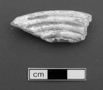
Fig. 53. Glass base-sherd V19.12.
- Glass Sherd V19.13
- Grid:
-
V19
- Shape:
-
Bodysherd.
- Description:
-
Thin-walled green glass bodysherd.
APPENDIX II: GILBERT BAGNANI AND KARPATHOS
by D.J. Ian Begg, Trent University
Gilbert Bagnani was born in Rome on 26 April 1900, the only child of General Ugo Bagnani, Italy's first military attaché in London from 1908 to 1911, and of his wife Florence Ruby Dewar, an heiress from Port Hope, Ontario. Bagnani grew up speaking Italian and English to his father and mother respectively, and attended private schools in Italy and England. His father died at the British front in northern France in February 1917. While a student at the University of Rome, his mentors were not only Thomas Ashby, the Director of the British School at Rome, and Mrs Eugenie Sellers Strong, the Assistant Director, but also Federico Halbherr, the éminence grise of Italian archaeologists, and Roberto Paribeni, arguably the most politically influential Italian archaeologist of his generation.
Even before he graduated Bagnani was academically ambitious. In 1920 he used his connections in Rome to arrange to lecture to the Hellenic Society in London on recent Italian excavations at Cyrene, about which he published an article (Bagnani Reference Bagnani1921, 232–46). He also wrote another article for the Roman Society about the recent discovery of the underground neopythagorean basilica in Rome (Bagnani Reference Bagnani1919, 78–85). In June 1921 he travelled alone on a potentially dangerous tour of the Italian-controlled territory of Cyrenaica to visit the Italian excavations at Cyrene. Both Bagnani and Doro Levi were awarded bursaries to attend the Italian School of Archaeology at Athens in December 1921.
Upon the discovery of the statue bases with their still-painted relief sculptures found in the Wall of Themistokles in Athens, Bagnani began writing anonymous articles for the Morning Post in London, thanks to his friendship with William Miller, who was another correspondent for the Post as well as an eminent historian of medieval Greece. After presenting a public lecture on the Roman Agora, Bagnani joined the School's director, Alessandro Della Seta, and the other students in travelling by foot, horseback, carriage, cars and trains around the Peloponnese and newly annexed north-west Greece. He found the medieval remains at Mistra and Rhodes much more captivating than the relatively exiguous remains of Classical temples. At that time the Dodecanese Islands were administered by Italy, which had occupied them when taking Libya from the Ottoman Empire in 1911, and the Italian archaeologists had a free rein to explore and excavate. While exploring Kos, Della Seta assigned an excavation of a Roman theatre to Bagnani but after a few weeks they discovered that it had been demolished (Livadiotti and Rocco Reference Livadiotti and Rocco1997, 156–8). Back in Greece, the students excavated the Cave of the Nymphs at Pharsalus, where Bagnani took and later developed the excavation photographs. After making a perilous ascent by suspended ladders to the monasteries on Meteora, Bagnani visited Knossos (where he commented, ‘too much Evans, too little Minos’), Phaistos and Gortyna in a swelteringly hot Crete.
Both Gilbert Bagnani and Doro Levi had their bursaries renewed to return for a second year at the School (1922–3). Along with Giulio Jacopich, the men sailed to Santorini, where they discerned traces of an ancient city (the brief notice in the Annuario was cited as the only evidence by Sperling [Reference Sperling1973]), later to Mount Athos to stay at the Byzantine monasteries there, and then on to the northern port city of Salonika, which was still being rebuilt after a disastrous fire in 1917.
When Bagnani sailed to Rhodes, he noted that he ‘[o]nly found Della Seta & Jacopich as Levi still has fever & Parlanti [the School's custodian and photographer] has not left him so all the hard work of photography falls on me’ for their journey to Karpathos. Della Seta's brief notices of this excursion in the Annuario (Della Seta Reference Della Seta1923–4, 563–5) and Bollettino d'Arte (Della Seta Reference Della Seta1924–5, 85) were cursory, but Bagnani's ten-page typewritten report survives unpublished in the archives of the Italian School. It is by far the most extensive of any of the descriptions of the area around Leukos left by any of the early travellers.Footnote 3 In addition, Bagnani wrote letters to his mother in Rome, and these are kept in the archives of the Art Gallery of Ontario in Toronto. So far, however, no photographs of this journey have been found either in Ontario or Athens or in the material handed over by the Italians to the Greeks on Rhodes in 1947.
After a very rough crossing from Rhodes via the island of Khalkis, Della Seta and the two students landed at Pigadhia on 12 June. Bagnani wrote a detailed description of an elaborate rock-cut tomb north-west of the Pigadhia, which has subsequently been published by Moutsopoulos (Reference Moutsopoulos1975–7, 173–80) and Melas (Reference Melas1985, 37–40). Using five mules, they crossed via Menetes to Arkassa on the west coast, where they discovered in the cemetery the upper of two large superimposed mosaic floors of Early Christian basilicas; these were published by Jacopich (Reference Jacopich1925 and Reference Jacopich1932–34–41). Della Seta decided to leave Jacopich to uncover the mosaic floors, and on 15 June Della Seta and Bagnani set out by mule for an eight-hour trek northwards to Leukos.
Here they first observed two circular buildings on the coast before inspecting the remains on top of the islet of Sokastro. After describing the large natural amphitheatre-like scarp at Rizes facing Sokastro with its artificially adapted cave dwellings, Bagnani observed on the plateau:
‘above the plain in the threshing floor of a certain Kallitza Johannidis there are some large rectangular blocks, some still in position, coming from a Greek building, perhaps a temple. Some blocks bear a simple cornice, others exhibit traces of double axe clamps which belong to a Hellenistic-Roman type that was with two teeth. The material is a marine conglomerate identical to that of the plain on which it rests. All the terrain is covered with sherds and there can be no doubt that it is the site of an ancient city, perhaps Nysiros [sic], the only one of the four cities of Karpathos whose site is still unknown. In the rocks near the temple there are numerous tombs similar to those of Arkassa, with arched openings and vaulted soffits. Others are readapted natural little caves. They were closed with a stone resting on a setback that surrounded the opening of it. The sindaco [mayor] of Mesochori, Paulos Lykos, said he had opened one and had found inside some bones and three lacrimatoi of colourless terracotta: evidently of the Roman period.’ (Bagnani unpublished [Reference Bagnani1923], 6–7; author's translation)
Della Seta and Bagnani then proceeded inland beyond the huge rock quarries at Pelekito (for illustrations, see Giovanopoulou and Sakeli Reference Giovanopoulou and Sakeli2003). At the locality of Ria, Bagnani described in detail the ‘large subterranean cistern’, which was later published by Moutsopoulos (Reference Moutsopoulos1975–7, 205) and Melas (Reference Melas1985, 42).
Della Seta and Bagnani then rode up to Elymbos, down to Vergounda, across to Diafani, by boat to Palatia on the island of Saria, and back to Pigadia by 23 June. Della Seta sailed away on 25 June, leaving the two students to work at Arkassa. On the great promontory rock Bagnani dug some trial trenches, wrote detailed descriptions and sketched plans of walls and remains around the upper levels of the promontory. After having George Pittas, the sindaco of Arkassa, sign a receipt on 5 July that he would be responsible for the exposed mosaic floors, Bagnani made his way back to Athens. On 20 July he wrote to his mother in Rome: ‘The heat is something frightful, much worse than anything we have had up till now, & I am developing all my photos: 18 dozen of them so by night I am simply a wreck.’
In May 1924 Bagnani returned once again briefly to Athens on his way to Constantinople and eastern Anatolia. In the late 1920s, he was assigned part of the Archaeological Map of central Italy and made many excursions outside Rome in the company of Thomas Ashby and Giuseppe Lugli. In 1929 he published The Roman Campagna and its Treasures, as well as Rome and the Papacy. After he and Mary Augusta Stewart Huston married in Toronto in 1929, Bagnani was invited by Carlo Anti to join the Italian excavations at the Greco-Roman sanctuary site of Tebtunis in the desert near the Fayyum oasis in Egypt. They discovered the intact sanctuary of the crocodile god, Sobek, including the papyri from the temple library. Immediately after a final season in 1936, Bagnani and Stewart sailed from Alexandria to Athens, and drove up through northern Greece and Serbia to Fiume on the Adriatic. After both their mothers died in 1935, Bagnani and his wife decided to emigrate to Port Hope, Ontario, where he bought and operated a cattle farm until invited to teach in the Classics Department at the University of Toronto in 1945. After retiring from there in 1965, both he and Stewart taught part-time at Trent University in Peterborough, Ontario. Bagnani died in 1985 and Stewart in 1996. They had neither siblings nor children, nor did either ever return to Greece.


