


Introduction
Anatolia is a land bridge that connects Africa, West Asia, and Europe. Thus, it should have been a critical route for hominins. Several studies have shown that Anatolia was possibly permanently occupied at least from the middle of the Middle Pleistocene (Minzoni-Déroche, Reference Minzoni-Déroche1987; Otte et al., Reference Otte, Yalçınkaya, Kozlowski, Bar-Yosef, Lopez Bayon and Taşkıran1998; Slimak et al., Reference Slimak, Kuhn, Roche, Mouralis, Buitenhuis and Balkan-Atlı2008; Güleç et al., Reference Güleç, White, Kuhn, Özer, Sağır, Yılmaz and Howell2009; Kuhn et al., Reference Kuhn, Dinçer, Balkan-Atlı and Erturaç2015; Dinçer, Reference Dinçer, Harvati and Roksandic2016; Taşkıran, Reference Taşkıran2018). Yet the hominin fossil record currently available for Anatolia is very limited, except for the Kocabaş hominins (assigned to Homo erectus) associated with the Lower Palaeolithic of Denizli province in south-western Turkey (Lebatard et al., Reference Lebatard, Alçiçek, Rochette, Khatib, Vialet and Boulbes2014). Lithic remains are thus essential sources for tracing hominin dispersal (Kuhn et al., Reference Kuhn, Dinçer, Balkan-Atlı and Erturaç2015). Inferring the activities of hominins is of particular relevance since the ecological and climatic conditions of Anatolia differ considerably from those of Africa (Dinçer, Reference Dinçer, Harvati and Roksandic2016), making occupation by hominins a challenge.
In this study, we present a lithic assemblage from a site located north of the village of Ulupamir in the district of Erciş in the province of Van in Turkey. The site is located on a landform called Gürgürbaba Hill (Gürgürbaba Tepesi in Turkish) (Figure 1A and B).
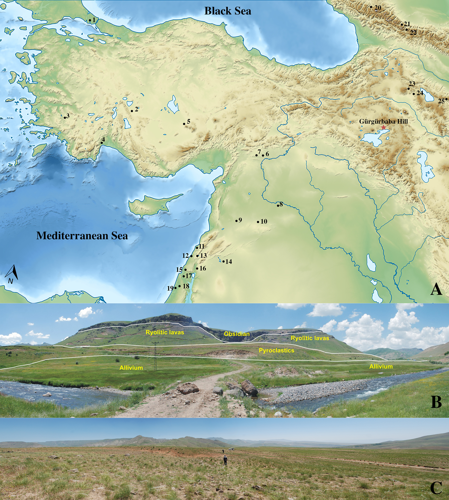
Figure 1. A. Location map of Gürgürbaba Hill site and distribution of Lower Palaeolithic sites in Turkey and neighbouring regions. Turkey: 1: Yarımburgaz Cave; 2: Dursunlu; 3: Kocabaş; 4: Karain Cave; 5: Kaletepe Deresi-3 (KD-3); 6: Nizip QF-II; 7: Dızmırtaşı. Levant: 8: Nadaouiyeh; 9: Latamne; 10: Hummal; 11: Hayonim; 12: Misliya Cave; 13: Jamal Cave; 14: Yabrud I rock shelter; 15: Tabun Cave; 16: Gesher Benot-Ya'aqov; 17: Revadim; 18: Qesem Cave; 19: Holon. Caucasus: 20: Treugol'naya Cave; 21: Kudaro I; 22: Kudaro III; 23: Dashtadem-3; 24: Nor Geghi 1; 25: Azıx (Azıh) Cave. B. Panoramic view of Gürgürbaba Hill from Ulupamir (looking towards west). The obsidian level is the raw material source for all of the Palaeolithic sites. C. Panoramic view of Locality 010.
Gürgürbaba Hill is a rich obsidian source. We started extensive fieldwalking surveys in 2014 to reveal the Palaeolithic potential and distributions in the area (Baykara et al., Reference Baykara, Dinçer, Şahin, Koç, Baykara and Özer2016, Reference Baykara, Dinçer and Şahin2018, Reference Baykara, Dinçer, Şahin, Eren, Ünal and Gülseven2020). During the 2014–2017 seasons, we undertook an intensive survey of Locality 010 using a ‘dog-leash’ method to collect material from circles 2 m in diameter. A total of 11,038 artefacts were recorded from 2012 observation points. We selected 2221 out of these 11,038 artefacts for detailed analysis. During the 2017–2019 seasons, we excavated selected areas at Locality 010 in order to establish its stratigraphy and obtain optically stimulated luminescence (OSL) and cosmogenic dating samples (Uslu et al., Reference Uslu, Baykara, Dinçer, Şahin and Ünal2020). The addition of 650 artefacts recovered from the excavation gives a total of 2871 artefacts studied in Locality 010.
Geology and Dating
Extensive volcanic areas characterize the geology of eastern Anatolia. Volcanic activity has produced obsidian-rich deposits covering relatively large areas, which are dated to the Neogene–Quaternary (Bigazzi et al., Reference Bigazzi, Yeğingil, Ercan, Oddone and Özdoğan1997). The Van basin has a continental climate that differs from other eastern Anatolian regions, with generally cold and wet winters and warm and dry summers (Çağatay et al., Reference Çağatay, Gretmen, Damcı, Stockhecke, Sancar, Eris and Özeren2014). The climate pattern of the Van region and eastern Anatolia was similar during interglacial periods, such as Marine Isotope Stage 9 (hereafter MIS 9; 330–300 kya bp). Nevertheless, core records from Lake Van indicate a lower temperature on average during the glacial periods than today. Furthermore, the climate around today's Lake Van fluctuated between cold and dry glacial periods and warm and wet interglacial periods over the last 360 ka, as documented by pollen, organic carbon, and authigenic carbonate content (Kwiecien et al., Reference Kwiecien, Stockhecke, Pickarski, Heumann, Litt and Sturm2014; Litt et al., Reference Litt, Pickarski, Heumann, Stockhecke and Tzedakis2014).
The Gürgürbaba Hill Palaeolithic sites are located 25 km from Lake Van and 6 km from the Meydan Mountain (altitude: 2320 m asl). Gürgürbaba Hill is a parasitic cone in the Erciş district, the primary source of the obsidian found on the Palaeolithic sites located on the upper part of the hill on a gentle south east-facing slope, at an elevation of approximately 2200 m asl. Four geological units were detected on the hill, consisting of a lava flow associated with the parasitic volcanic cone of Gürgürbaba Hill. These lava deposits contain obsidian. On top of the obsidian layer, colluvial sediments c. 3 m thick with intercalated soil horizons were deposited. The Palaeolithic artefacts are thus only visible in recently uncovered drainages, generally in fresh drainage beds, or in eroded areas.
The obsidian from the Meydan Mountain area has been dated in several studies: 0.48 and 0.99 mya by Matsuda (Reference Matsuda1988, Reference Matsuda1990), by K/Ar method on the lava; 0.80 mya by Innocenti et al. (Reference Innocenti, Mazzuoli, Pasquare, Serri and Villari1980), through the K/Ar method on obsidian lava called the Ziyaret formation in the south-east of the Meydan caldera; 0.89 to 0.79 mya by Bigazzi et al. (Reference Bigazzi, Dompnier, Hadler Neto, Poupeau and Vulliez1988, Reference Bigazzi, Yeğingil, Ercan, Oddone and Özdoğan1997), using the fission track method on the same obsidian lava as Innocenti et al. (Reference Innocenti, Mazzuoli, Pasquare, Serri and Villari1980). In order to provide a secure chronology for the site's obsidian, we applied the 40Ar/39Ar dating method to a sample of the Gürgürbaba obsidian taken from sector D (Ulupamir), with a result of 0.42 mya (Akköprü et al., Reference Akköprü, Tunç, Robin and Mouralis2019).
To conduct OSL analyses, we collected five samples of the archaeologically sterile topsoil layers A3 to A1 at Locality 010 (Figure 2). The OSL showed the date range to be between 12.1±0.5 and 2.7±0.4 kya. The usually fresh, un-rolled, and unabraded surfaces of the recovered artefacts suggest that these layers were quickly covered by topsoil shortly after the Palaeolithic occupation of the site. Additionally, the fact that cores and flakes could be refitted indicates that the artefacts had not moved since their deposition. However, the OSL dates were much more recent than expected. This could be a result of contamination by fissures in the layers. As detailed below, a sample for cosmogenic exposure dating was taken adjacent to where the Lower Palaeolithic artefacts were recovered, very close to cores and flakes that could be refitted. For this reason, we concluded that the results of OSL dating reflect recent contamination.

Figure 2. Photographs and schematic drawing of the archaeological layers in the Locality 010 test trenches.
Cosmogenic Exposure Dating
We used the terrestrial cosmogenic nuclides (TCN) dating method to calculate the duration of exposure of rocks and sediments on the surface of the Earth. This method is based on the measurements of rare isotopes (such as 10Be, 26Al, or 36Cl) produced via nuclear interactions between secondary cosmic rays and the target atoms of the rocks (Dunai, Reference Dunai2010; Ulusoy et al., Reference Ulusoy, Sarıkaya, Schmitt, Şen, Danišík and Gümüş2019).
From the surface of Locality 010, we collected a semi-rectangular boulder measuring 25 × 15 × 5 cm. Sample location, attributes, and local corrections to production rates are shown in Table 1. The sample was prepared at the Istanbul Technical University/Kozmo-Laboratory. The TCN followed the protocols described in Sarıkaya (Reference Sarıkaya2009) and Schimmelpfennig et al. (Reference Schimmelpfennig, Benedetti, Finkel, Pik, Blard and Bourlès2009). The sample was originally buried approximately 110 cm below the surface with a bulk density of 1.22 g cm3 but, since the soil was eroded before excavation, we measured the bulk density of the soil using gravimetric methods. A soil cover correction factor of 0.4574 was applied to the age calculations. We used the 36Cl production rates reported in Marrero et al. (Reference Marrero, Phillips, Caffee and Gosse2016)—56.3±4.6 atoms 36Cl (g Ca)-1 a-1 for Ca spallation, 153±12 atoms 36Cl (g K)-1 a-1 K spallation and 74 ±179 fast neutrons (g air)-1 a-1— (Borchers et al., Reference Borchers, Marrero, Balco, Caffee, Goehring and Gosse2016; Marrero et al., Reference Marrero, Phillips, Caffee and Gosse2016; Phillips et al., Reference Phillips, Argento, Balco, Caffee, Clem and Dunai2016). They were scaled following the time-dependent Lifton-Sato-Dunai method (so-called LSD or SF scaling) (Lifton et al., Reference Lifton, Sato and Dunai2014). All essential information, including the 36Cl concentrations and scaling factors to reproduce the resultant ages, is given in Table 1.
Table 1. Cosmogenic 36Cl sample data.

The exposure age of the sample was calculated as 311±32 ka. We disregarded the possibility of any inherited cosmogenic nuclide, due to lack of data. However, taking the relatively recent formation of the host rock (rhyolite, ~420 ka) into consideration (Akköprü et al., Reference Akköprü, Tunç, Robin and Mouralis2019), the age obtained by TCN may be considered as the maximum age of the site.
Lithic Technology and Typology at Locality 010
We classified the retouched tools based on the morphological features proposed in Bordes’ (Reference Bordes1961) typology for the Lower and Middle Palaeolithic. For the description of the basic technological features, this study follows the terminology published by Van Peer (Reference Van Peer1992), Debénath and Dibble (Reference Debénath and Dibble1994), Boëda (Reference Boëda, Dibble and Bar-Yosef1995), Inizian et al. (Reference Inizan, Reduron-Ballinger, Roche and Tixier1999), Kuhn et al. (Reference Kuhn, Stiner, Güleç, Özer, Yılmaz and Baykara2009), and Baykara et al. (Reference Baykara, Mentzer, Stiner, Asmerom, Savaş-Güleç and Kuhn2015). Out of 11,038 chipped stone (obsidian) artefacts identified at Locality 010, 2871 (2221 exemplars from survey and 650 from excavation) were examined in detail from a technological and typological perspective; these artefacts comprise 2091 blanks, 315 bifaces, 431 cores, and twenty-seven large retouched tools.
The Locality 010 artefacts include handaxes, large irregular cores, large flakes and blades, and Levallois cores and blanks, as well as non-Levallois cores and blanks. The presence of Levallois products at Locality 010 is consistent with the use of this technology in the southern Caucasus (Adler et al., Reference Adler, Wilkinson, Blockley, Mark, Pinhasi and Schmidt-Magee2014). Table 2 shows the proportions and characteristics of the handaxes, which are the best-known component of Acheulean technology (Figure 3). The handaxe assemblage analysed consists of 315 items, all made of obsidian, and this is currently the largest handaxe sample known in Anatolia. The handaxes are patinated and show considerable but variable weathering. Most were complete (n = 266), while forty-nine were fragmented, and these fragments are not included in the typological description of the handaxes. Handaxe blanks consist primarily of flakes (51 per cent), the remaining half consisting of roughly equal proportions of nodular and tabular pieces, angular chunks, and indeterminate pieces. The non-cortical handaxes number 285 (90.5 per cent of the bifaces), whereas the cortical handaxes comprise thirty bifaces (9.5 per cent). Among those with cortex, twenty-six pieces had cortex on one side, and four had cortex on both the dorsal and ventral faces. Both bifacial (58 per cent) and unifacial (30 per cent) handaxes were represented in the assemblage, along with a small percentage of preforms and partial bifaces. Plano-convex and biconvex cross-sections are almost equally represented among the handaxes. At the proximal end of the handaxes, flat or oval shapes were found in most cases, and pointed shapes were represented in only a few pieces. At the distal end, on the other hand, pointed shapes were found in almost half of the total, the remainder showing flat, oval, or slightly constricted shapes in similar frequencies. Different kinds of percussion techniques (hard hammer, hard hammer with soft hammer shaping of the edge, and soft hammer) were used for shaping the handaxes. Almost half the handaxes show only traces of hard-hammer percussion. Slightly fewer handaxes exhibit traces of both of hard- and soft-hammer percussion, while much fewer have traces of soft-hammer percussion only.

Figure 3. Amygdaloid (1–4) and cordiform handaxes (5–8) from the Locality 010 survey.
Table 2. Technological properties of handaxes (indet.: indeterminate) and typology of handaxes.

Several typological patterns are discernible in the assemblage (Table 2). The flatness of the handaxes, evaluated by flatness indexes, varies across the assemblages, with flat handaxes slightly more numerous than thick handaxes. The elongation of the handaxes, evaluated by the elongation index Ie, was also heterogeneous across the assemblage, with most of the elongation index higher in the thick handaxes (>1.5: 83; < 1.5: 44) than in flat handaxes (>1.5: 55; <1.5: 88). Cordiform and amygdaloid types are represented in almost equal proportions. The Locality 010 handaxes are generally characterized by their rounded shape in their proximal parts and pointed shape at the distal end with overall heart/amygdaloid shapes.
Blanks and orientation of their dorsal scars are presented in Table 3. It is apparent that the strategies of debitage were oriented towards the production of flakes (80 per cent) rather than blades (17 per cent). The plain flakes (46.2 per cent) are the most common blank type, followed by much lower numbers of Levallois flakes and large flakes. Although blade production was a minimal component, plain blades are more common than Levallois blades. The variety of core-shaping pieces (éclat débordant, pseudo Levallois point, core edge) and cortical flakes shows that cores were probably reduced in situ. A few Levallois points were also found in the assemblage. Large flakes and blade blanks (n = 162) were recorded according to their length or width, and thickness: that is, when either the width or length is greater than 10 cm (average width and length: 8 cm and 12 cm, respectively) and the blanks derive from plain or cortical platforms.
Table 3. Representation of blanks and orientation of dorsal scars on blanks (Con-sym: convergent symmetric; con-asym: convergent asymmetric; Multi./Orth: multi-directional/orthogonal; Indet: indeterminate).

The orientation of dorsal scars on Levallois (flakes, blades, and points) and non-Levallois blanks (plain flakes and blades, large flakes and blades) is detailed in Table 3. Levallois and non-Levallois groups show a similar pattern of dorsal scar orientation. Within the Levallois group, multi-directional/orthogonal and parallel dorsal scars are the most common. Convergent scar patterns are attributed to Levallois point production as well as convergent preparation. Parallel dorsal scar orientations, indicative of unidirectional and bidirectional Levallois reduction, are somewhat more common throughout the assemblages. Multi-directional/orthogonal scars are probably related to Levallois centripetal core reduction. Dorsal scar patterns on the non-Levallois blanks are similar to those on the Levallois pieces, while the production of non-Levallois blanks seemingly shows greater homogeneity. Parallel and multi-directional/orthogonal dorsal scars are abundant on all blank types (49.5 and 42.4 per cent of the total, respectively), while convergent scar patterns are comparatively rare. Considering only flakes with multiple dorsal scars, many non-Levallois flakes with multi- directional dorsal scar patterns may be pieces derived from the preparation and shaping of unifacial cores.
Table 4 shows the proportions of core types (illustrated in Figure 4) represented at Locality 010. Although the percentages of Levallois flakes and blades among the blanks are relatively low, the percentage of Levallois cores (49.2 per cent) is slightly higher than the other core types. The category of non-Levallois unifacial core refers to the cores that had removals from one flat face without preparation of the platform or the lateral edges; thus, the removals were not predetermined, in contrast to the Levallois system (Baykara et al., Reference Baykara, Mentzer, Stiner, Asmerom, Savaş-Güleç and Kuhn2015). For the most part, these cores were worked from only one platform, which could have resulted in flakes and blades with parallel scars. There are no large cores large enough to have produced the largest flakes and blades observed in the assemblage. Cores with a single removal constitute only 16.01 per cent of the total. The platform orientation of the cores and the dorsal scars of the blanks are similar to each other. Centripetal and parallel dorsal scars on the blanks correspond to cores with centripetal and unidirectional Levallois and non-Levallois cores. Additionally, the prevalence of parallel dorsal scars in the blanks is present in both the uni/bidirectional Levallois cores and the non-Levallois unifacial cores. This indicates that the production of the blanks and the shaping of the cores was homogeneous.

Figure 4. Cores and retouched tools from the Locality 010 survey. A: Levallois unidirectional core; B: Levallois bidirectional core; C, D: centripetal Levallois core; E: Levallois Point core; F: unifacial; G, H: Levallois unidirectional core; I, J, L, O, P: single convex side scraper; K: tranverse side scraper; M, N: Levallois point.
Table 4. Proportions of core types.

Figure 5 shows the frequency of retouched tool types at Locality 010. Overall, the assemblages contain relatively high numbers of side scrapers (almost half of the tools), Levallois products (about a quarter), and denticulates/notches, but there are few points or Upper Palaeolithic tool types. Single scrapers (the largest groups of scrapers), double, and transverse side scrapers are frequent among the scraper types. In addition to this, déjeté side scrapers, side scrapers on ventral surfaces, side scrapers with bifacial retouch, and alternate retouched side scraper types are represented (Figure 4). Following Bordes’ (Reference Bordes1961) typology, the most prominent group of tools besides the side scrapers are typical and atypical Levallois flakes. In addition, notched and denticulate tool types were recorded. Levallois or other point types, present in our sample, are scarce in Middle and Lower Palaeolithic assemblages in Anatolia. Large retouched tools, also present at Locality 010, are among the preferred tools in these assemblages, and they are sharing the single side scraper morphology.

Figure 5. Retouched tool types and their frequency.
Discussion
At Gürgürbaba Hill, the Locality 010 lithic assemblage contains handaxes, large irregular cores, large flakes and blades, and Levallois cores and blanks, as well as non-Levallois cores and blanks. The Late Acheulean assemblage is dominated by bifacial and unifacial handaxes, along with flake production with Levallois and non-Levallois techniques. Most of the handaxes found at the site were well preserved and complete, dominated by cordiform and amygdaloid shapes. The debitage of Levallois and non-Levallois cores was oriented towards the production of flakes. The origin and orientation of the dorsal scars on the Levallois and non-Levallois blanks show evidence of a similar and homogeneous production. The retouched tool types contain relatively high frequencies of side scrapers, Levallois products, denticulates/notches, and points. Fine retouched single side scrapers were the main scraper type in the Late Acheulean assemblages of Gürgürbaba Hill.
Anatolia forms a land bridge between Africa and Eurasia, and its palaeo-climate and geological formation could have been habitable by Palaeolithic hominins. Artefact assemblages found in various locations in Anatolia suggest that hominins passed through or occupied the area since the arrival of one the first members of the genus Homo. Although relatively many localities with Lower Palaeolithic artefacts have been identified in Turkey, systematic research is still limited to a few sites, such as Dursunlu (Güleç et al., Reference Güleç, White, Kuhn, Özer, Sağır, Yılmaz and Howell2009), Kaletepe Deresi-3 (KD3; Slimak et al., Reference Slimak, Kuhn, Roche, Mouralis, Buitenhuis and Balkan-Atlı2008), Yarımburgaz Cave (Kuhn et al., Reference Kuhn, Arsebük and Howell1996), and Karain Cave (Otte et al., Reference Otte, Yalçınkaya, Kozlowski, Bar-Yosef, Lopez Bayon and Taşkıran1998). Our study adds substantially to evidence that Anatolia was settled by hominin palaeo-demes.
Gürgürbaba Hill differs from previously recorded lithic assemblages recorded at Yarımburgaz Cave, Karain Cave, and Dursunlu, in that it contains abundant handaxes and Levallois reduction evidence. Specifically, comparison of the Locality 010 lithic assemblages with KD3's shows a difference, in that asymmetric handaxes and cleaver-flake technologies associated with choppers/chopping tools and polyhedrons were produced at KD3 (Slimak et al., Reference Slimak, Kuhn, Roche, Mouralis, Buitenhuis and Balkan-Atlı2008). On the other hand, both sites produced large cores and flakes. At KD3, large cores were produced from raw materials such as andesite, basalt, or rhyolite, and no such cores were produced from obsidian. In this respect, the KD3 large core and flake tools differ from those from Gürgürbaba Hill. Likewise, Kuhn et al. (Reference Kuhn, Dinçer, Balkan-Atlı and Erturaç2015) identified ‘large flake Acheulean’ material in surveys across the Göllü Dağ region, but handaxes and chopping tools differ from those found at Locality 010 since these were produced from obsidian at Gürgürbaba and other lavas at Göllüdağ.
Numerous Lower Palaeolithic remains have been identified in various surveys of Anatolia (see http://www.tayproject.org). Unfortunately, no radiometric dating has ever been undertaken, and the Lower Palaeolithic period has been described only through the technological and typological characteristics of chipped stone tools. Nevertheless, two localities, Nizip (Minzoni-Déroche, Reference Minzoni-Déroche1987) and Dızmırtaşı (Taşkıran, Reference Taşkıran2018) in south-eastern Anatolia, appear to be contemporary with Gürgürbaba Hill, based on the nature of the Late Acheulean industry.
The Nizip surveys were carried out on the terraces of the Euphrates (Quaternary alluvium I-II-III). The handaxes collected from the layers of the Quaternary alluvium II, defined as belonging to the Upper Acheulean period, are estimated to be older than 300,000 years, according to radiometric dating of terrace deposits in Syria along the Euphrates (Minzoni-Déroche, Reference Minzoni-Déroche1987). Within the Dızmırtaşı-Karkamış Dam project on the Euphrates, seventy-four handaxes were identified as having Late Acheulean typological characteristics (Taşkıran, Reference Taşkıran2018). The Gaziantep Quaternary alluvium II (Minzoni-Déroche, Reference Minzoni-Déroche1987) and Dızmırtaşı (Taşkıran, Reference Taşkıran2018) localities resemble Gürgürbaba Hill, in that they contain Late Acheulean handaxes and Levallois products. However, the widespread production of handaxes by hard hammering at Gürgürbaba Hill differs from that found at Nizip and Dızmırtaşı. The latter yielded artefacts made from flint, and thus these differences may reflect the use of different raw material sources. In addition, picks were not found in the Gürgürbaba Hill stone tool assemblages; however; they were found at Gaziantep and Dızmırtaşı.
Some Lower Palaeolithic sites are known from the northern Caucasus (see Figure 1A), but they have not been dated, hence the information that could be gained from them is limited. The best-defined Lower Palaeolithic site in the region is Treugolnaya Cave (Doronichev, Reference Doronichev, Lordkipanidze, Bar-Yosef and Otte2000). The cave is dated to c. 600–300 kya (OIS 15–11), and four different industries have been identified as belonging to the Lower Palaeolithic (Doronichev & Golovanova, Reference Doronichev and Golovanova2010). The Palaeolithic finds from the cave differ from those of Locality 010 in that Acheulean-type handaxes and Levallois debitage are absent, and chopping tools are present. In contrast to the northern Caucasus, it is in the Palaeolithic sequence of the southern Caucasus that Acheulean handaxes are produced using the Levallois technique.
The Late Acheulean period is well known from southern Georgia, Azerbaijan, and Armenia (Doronichev, Reference Doronichev, Lordkipanidze, Bar-Yosef and Otte2000, Reference Doronichev2008; Kolpakov, Reference Kolpakov2009; Adler et al., Reference Adler, Wilkinson, Blockley, Mark, Pinhasi and Schmidt-Magee2014). One of the best-known sites, the Late Acheulean open-air site of Nor Geghi 1, is located in the Hrazdan Gorge in the Armenian volcanic highlands of the southern Caucasus. Nor Geghi 1 (NG1) was dated using the 40Ar/39AR method and the date ranges between 197 and 441 kya. The site's lithic assemblage is manufactured on obsidian. As Adler and colleagues (Reference Adler, Wilkinson, Blockley, Mark, Pinhasi and Schmidt-Magee2014) report, unifacial (hierarchical core) (26.3 per cent) and Levallois cores (44.7 per cent) are represented, and both preferential (35.3 per cent, n = 6) and recurrent (23.5 per cent, n = 4) Levallois methods are used. The Levallois cores’ dorsal patterns are dominated by unidirectional, bidirectional, and centripetal removals. Levallois flakes and blades typically exhibit plain or faceted platforms, and dorsal scar patterns are unidirectional. The bifaces are morphologically similar to Late Acheulean bifaces. Scrapers of various types dominate the retouched tools, and there is a relatively high frequency of single (23.1 per cent) and transverse (12.3 per cent) retouch at NG1 (Adler et al., Reference Adler, Wilkinson, Blockley, Mark, Pinhasi and Schmidt-Magee2014). According to Adler et al. (Reference Adler, Wilkinson, Blockley, Mark, Pinhasi and Schmidt-Magee2014), the NG1 lithic assemblages are characterized by the use of bifacial and Levallois technology, with Quina-type (stepped) retouch and blade production, which occurs towards the end of the Late Acheulean. The NG1 Late Acheulean industry is quite similar to the lithic tool assemblages recovered at Locality 010. Quina retouch tools were not found there, but this might be related to environmental factors: indeed, copious raw materials were available in the vicinity of Gürgürbaba Hill, thus highly retouched tools were not required, in contrast to NG1.
The Late Acheulean industry in the Levant is well known, and this period is divided into the early and late Upper Acheulean (Bar-Yosef, Reference Bar-Yosef, Petraglia and Korisettar1998). The early Upper Acheulean in the Levant is generally characterized by an increase in handaxes shaped by soft hammering, the use of flint or other siliceous raw materials, and fewer tools such as choppers and picks (Gilead, Reference Gilead1970; Le Tensorer et al., Reference Le Tensorer, Jagher, Rentzel, Hauck, Ismail-Meyer and Pümpin2007; Jagher, Reference Jagher2016; Sharon, Reference Sharon, Enzel and Bar-Yosef2016; Moncel et al., Reference Moncel, Arzarello, Boëda, Bonilauri, Chevrier and Gaillard2018). The Levantine late Upper Acheulean is characterized by the presence of ovate and pointed handaxes (McPherron, Reference McPherron, Soressi and Dibble2003; Zaidner et al., Reference Zaidner, Druck, Weinstein-Evron, Goren-Inbar and Sharon2006; Gisis & Ronen, Reference Gisis, Ronen, Goren-Inbar and Sharon2006) and the non-Levallois manufacture of blades, broad-thick flakes, and Quina scrapers (Adler et al., Reference Adler, Wilkinson, Blockley, Mark, Pinhasi and Schmidt-Magee2014; Malinsky-Buller, Reference Malinsky-Buller2014; Sharon, Reference Sharon, Enzel and Bar-Yosef2016; Shimelmitz et al., Reference Shimelmitz, Weinstein-Evron, Ronen and Kuhn2016). This period, also known as the Acheulo-Yabrudian complex, constitutes the most recent period of the Lower Palaeolithic, which precedes the Levantine Mousterian (Jelinek, Reference Jelinek1982).
Revadim Quarry and Holon, Levantine Acheulo-Yabrudian assemblages of the Middle Pleistocene, are located in the central coastal plain of Israel; the sites are dated as ranging from c. 403 to 194 kya and 200 kya, respectively (Marder et al., Reference Marder, Khalaily, Rabinovich, Gvirtzman, Wieder and Porat1999, Reference Marder, Milevski, Matskevich, Goren-Inbar and Sharon2006; Malinsky-Buller, Reference Malinsky-Buller2014, Reference Malinsky-Buller2016; Agam & Barkai, Reference Agam and Barkai2018). The lithic assemblages from both localities are similar to those from other late Lower Palaeolithic Levantine sites in terms of techno-typological characteristics. The Revadim assemblages are dominated by flake-production technologies and flake tools, and characterized by handaxes, irregular, discoidal/ovate forms, choppers, cores on flake, and scrapers, which are made with Quina retouch within the Acheulo-Yabrudian complex (Marder et al., Reference Marder, Khalaily, Rabinovich, Gvirtzman, Wieder and Porat1999, Reference Marder, Milevski, Matskevich, Goren-Inbar and Sharon2006). The lithics from Holon are dominated by flakes and flake tools, cores on flakes (the most common reduction), and handaxes. Retouched items, side scrapers, and composite tools are the main elements of the toolkit at Holon (Malinsky-Buller, Reference Malinsky-Buller2014, Reference Malinsky-Buller2016).
The Late Acheulean at Gürgürbaba Hill shows some similarities with the Acheulo-Yabrudian of the Levant in terms of the use of handaxes in lithic assemblages, but it differs from the Acheulo-Yabrudian in some important ways: absence of Quina-type scrapers, use of Levallois technology, and minimal use of soft hammering in the manufacture of handaxes. These differences are probably owed to variation in the raw materials that reflects the different geographical conditions of the Levant and Anatolia. This, in turn, indicates adaptability in human behaviour. It is important to note that there is often a difference in Middle Pleistocene assemblages between caves and open-air sites. Typically, assemblages from natural shelters are dominated by flake tools, though a few Acheulean assemblages have also been found in some caves. In contrast, open-air sites are typically represented by Acheulean-type handaxes. These open-air sites or surface collections, such as Umm Qatafa (layers E and D), are geographically close to Gürgürbaba Hill (Gilead, Reference Gilead1970; Jelinek, Reference Jelinek1982; Bar-Yosef, Reference Bar-Yosef1994; Malinsky-Buller, Reference Malinsky-Buller2014, Reference Malinsky-Buller2016; Shimelmitz et al., Reference Shimelmitz, Weinstein-Evron, Ronen and Kuhn2016).
North-eastern Anatolia (the Kars, Ardahan, Iğdır, Ağrı, and Van regions featuring in this study) constitutes a border between Anatolia and the southern Caucasus. Because of their proximity, the two regions may have shared the same Palaeolithic material culture. It appears that the lithic tool assemblages from Locality 010 are similar to the Late Acheulean industry from the volcanic terrain in the southern Caucasus, particularly Nor Geghi 1. It is unlikely that this similarity is owed to a recent migration or dispersal of hominins into the area. More plausibly, Gürgürbaba Hill reflects local adaptations of late Middle Pleistocene hominins to high plateau environments. As at other Late Acheulean sites in Anatolia, there are similarities in the use of handaxes between the Late Acheulean assemblages from the Levant and Locality 010, although the latter differs from the former by the absence of Quina-type scrapers and the use of Levallois technology.
Conclusions
Anatolia, which links the Levant, the Caucasus, Central Asia, and eastern Europe, was likely to have been a pathway for hominin palaeo-demes. In this study, we present lithic evidence of hominin habitation dated to approximately 300 kya in a region of Anatolia, at Locality 010. The site's lithic assemblages are characterized by handaxes, large irregular cores, large flakes and large blades, Levallois cores and blanks, and non-Levallois cores and blanks. The debitage of Levallois and non-Levallois cores was oriented towards the production of flakes. The retouched tool types include relatively frequent side scrapers and denticulates/notches.
Our survey in Van province revealed chipped stone remains that belong to Lower Palaeolithic sites in the area of Gürgürbaba Hill. Among them, Locality 010 was identified as Late Acheulean, i.e. attributed both culturally and typologically to the Lower Palaeolithic period. The cosmogenic dating strongly supports this, yielding a maximum date of 311±32 kya. The hill would thus have been occupied by people during MIS 9, in a Middle Pleistocene interglacial period. Given the hill's harsh conditions in winter, it is likely that hominins used this area during the early summer to mid-autumn. Beyond the results obtained for Gürgürbaba Hill, our study illustrates the importance of conducting detailed surveys, obtaining precise dates, and gathering climatic data during the Acheulean period in eastern Anatolia.
Acknowledgments
This work was supported by the Turkish Historical Society, under Grants 2016.49, 2017.90, 2018.86, and 2019.72, and by Van-Yüzüncü Yıl University, under Grants SBA2017-5509 and 2014-EDB218. The site of Gürgürbaba Hill was investigated within a project titled ‘The Survey of the Pleistocene Period at Van’ initiated by the authors. We would like to express our sincere gratitude to the staff of the Van Regional Cultural Heritage Conservation Board Directorate, and the Van Archaeology Museum Directorate for their valuable contributions. We are most grateful to Fikret Yaşar who provided accommodation in Erciş. Erkan Konyar provided field equipment. We are also grateful to Naoki Morimoto (Department of Biological Science, Kyoto University), Amy E. Clark (Department of Anthropology, Harvard University), and Engin Sönmez (Department of Sociology, University of Essex, Colchester) for language revision. Finally, we would like to thank the editors and anonymous reviewers and our proof-reader.


