


INTRODUCTION
Landscapes of the southern Caucasus region between the Black and Caspian seas are sensitive to external climatic or anthropogenic controls. This is demonstrated by shrinking or disappearance of mountain glaciers (Gobejishvili, Reference Gobejishvili2004; Messager et al., Reference Messager, Belmecheri, Grafenstein, Nomade, Voinchet, Ollivier, Mgeladze, Lordkipanidze, Mazuy and Moreau2013), varying loess deposition (Wolf et al., Reference Wolf, Baumgart, Meszner, Fülling, Haubold, Sahakyan, Meliksetian and Faust2016), large-scale river migrations (Suchodoletz et al., Reference Suchodoletz, von, Gärtner, Hoth, Umlauft, Sukhishvili and Faust2016), and fundamental changes of the vegetation cover (Connor and Kvavadze, Reference Connor and Kvavadze2008; Joannin et al., Reference Joannin, Ali, Ollivier, Roiron, Peyron, Chevaux, Nahapetyan, Tozalakyan, Karakhanyan and Chataigner2014) during the late Quaternary. However, despite this recent palaeoenvironmental research, knowledge is still limited about former geomorphological processes and environmental conditions in the southern Caucasus. Additional geomorphological and paleoenvironmental research in the southern Caucasus may provide better understanding of: (1) how southern Caucasian landscapes will respond to changing climatic and anthropogenic conditions (Keggenhoff et al., Reference Keggenhoff, Elizbarashvili, Amiri-Farahani and King2014; Gogichaishvili, Reference Gogichaishvili2016); and (2) former diachronic human-environmental interactions in this region that was located at the northern periphery of the Near Eastern ancient world and was intensively settled beginning in the Neolithic period (Fig. 1 inset; Lordkipanidze, Reference Lordkipanidze2002; Akhundov, Reference Akhundov2004; Connor and Sagona, Reference Connor and Sagona2007; Fort et al., Reference Fort, Pujol and Vander Linden2012).
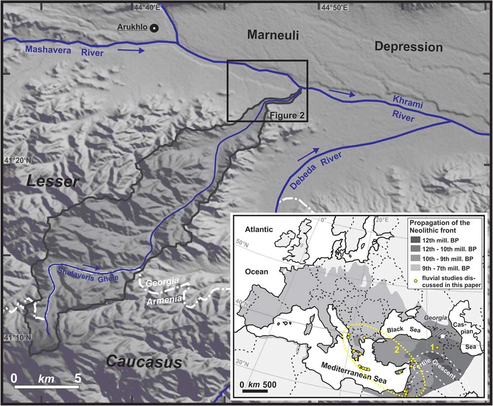
Figure 1 (color online) Map of the study area based on an ASTER-DGM. The catchment of the Shulaveris Ghele River is indicated with a black line. Inset: Location of the study area (white rectangle) at the northern periphery of the Near Eastern ancient world. Propagation of the Neolithic front from the Fertile Crescent towards the North and the West is based on Fort et al. (Reference Fort, Pujol and Vander Linden2012). Georgia is indicated with hatching and the Fertile Crescent with a white dashed line. Other fluvial studies mentioned in this paper: (1) rivers in the Pasinler Basin in eastern Turkey (Collins et al., Reference Collins, Rust, Bayraktutan and Turner2005); (2) compilation of several eastern Mediterranean rivers (Benito et al., Reference Benito, Macklin, Zielhofer, Jones and Machado2015). The study of Suchodoletz et al. (Reference Tokuyasu, Tanaka, Tsukamoto and Murray2015) is so close that it could not be shown with an own symbol.
In part to address these questions, we reconstructed late Quaternary fluvial dynamics and landscape development along the lower Shulaveris Ghele River in southeastern Georgia using geomorphologic, stratigraphic, and geochronologic methods. Besides providing information on the regional palaeoenvironmental and geomorphological evolution during the late Quaternary, a second focus of this study is to provide a better palaeoenvironmental context for the late Neolithic Shulaveri settlement group. This settlement group is located in the study area, and its former landscape context is hardly understood so far (Hamon et al., Reference Hamon, Jalabadze, Agapishvili, Baudouin, Koridze and Messager2016). The group forms part of the well-developed sedentary Shulaveri-Shomutepe (also called Aratashen-Shulaveri-Shomutepe; Chataigner et al., Reference Chataigner, Badalyan and Arimura2014) culture, the first Neolithic culture in semi-humid to arid SE-Georgia, western Azerbaijan, and Armenia that had developed from about 8 ka. Its economy was characterized by a fully developed agro-pastoral economy including the world’s first viniculture (Kiguradze, Reference Kiguradze1986, Reference Kiguradze2000; Hamon, Reference Hamon2008; Hamon et al., Reference Hamon, Jalabadze, Agapishvili, Baudouin, Koridze and Messager2016; Lyonnet et al., Reference Lyonnet, Guliyev, Bouquet, Bruley-Chabot, Samzun, Pecqueur and Jovenet2016). Due to its central location in the southern Caucasus, investigations of the Shulaveri settlement group have the potential to significantly contribute to the overall understanding of regional Neolithisation (Hamon et al., Reference Hamon, Jalabadze, Agapishvili, Baudouin, Koridze and Messager2016).
STUDY AREA
The ~35 km long southwest-northeast directed Shulaveris Ghele (also: Shulavericai) River runs from the Lesser Caucasus Mountains in the Armenian/Georgian borderland into the Marneuli Depression in southeast Georgia (denomination after Maruashvili, Reference Maruashvili1971) which is the lowest part of the Kvemo Kartli plain. Here, the Shulaveris Ghele flows into the larger Khrami River, which drains via the Kura River into the Caspian Sea. The Shulaveris Ghele catchment covers about 155 km2 and extends from 2,500 down to 360 m asl. Catchment annual precipitation is as much as 800 mm in the semi-humid Lesser Caucasus Mountains but diminishs to less than 400 mm in the semi-arid Marneuli Depression. The Shulaveris Ghele River is perennial with a mean annual discharge of 0.78 m3/s and a monthly discharge peak during May of 1.13 m3/s (data 1976–1985; http://rda.ucar.edu/data/ds553.2/fsu2). The catchment is primarily underlain by mostly volcanic Cretaceous and Jurassic rocks but also by sandstones, limestones, and marls (Gamkrelidze, Reference Gamkrelidze2003). The contemporary natural vegetation of the catchment in the Lesser Caucasus are oak-hornbeam woods and, in the Marneuli Depression, xerophytes and semideserts dominated by Poaceae-Chenopodiaceae-Artemisia associations (Connor et al., Reference Connor, Thomas, Kvavadze, Arabuli, Avakov and Sagona2004; Connor and Kvavadze, Reference Connor and Kvavadze2008).
The Shulaveris Ghele River enters the Marneuli Depression 4 km southwest of its confluence with the Khrami River, forming a fan-shaped alluvial surface inclined about 1.6 % to the northeast towards the Khrami River. The junction of the Shulaveris Ghele with terraces and floodplain of the Khrami River is marked by a several-meter-high scarp. At the apex of the Shulaveris Ghele fan, a relict channel diverges north from the active channel towards the Khrami River (Fig. 2). The current SW-NE eastern river has incised an U-shaped valley into the fan, with a depth between 5 and 7 m and a width of 30 to 40 m. Here, in most parts the Shulaveris Ghele is a meandering single-channel gravel-bed river with some straight segments. Apart from recent incision of about 1 m, no terraces are inset into the valley (Fig. 3A). The inactive western river bed is between 50 and 60 m wide and preserved as an U-shaped valley incised as much as 14 m into the fan-shaped surface. Where it joins the Khrami valley, the former channel bed ends in a small alluvial fan deposited on a Khrami River terrace with a tread about 9 m above the present river level (Fig. 3B).
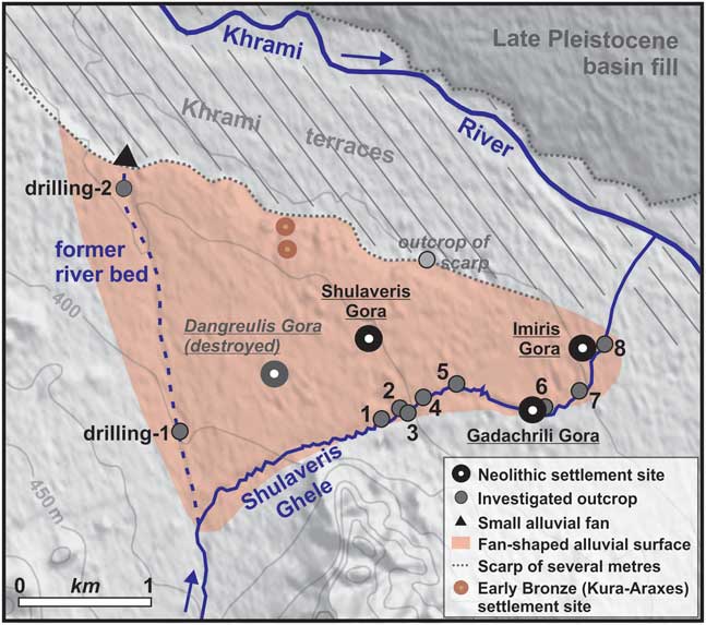
Figure 2 (color online) The study area along the lower course of the Shulaveris Ghele River. DEM-source: ALOS Science Project, Earth Observation Research Center (EORC), Japan Aerospace Exploration Agency (JAXA).

Figure 3 (color online) Views from the north towards the Lesser Causcasus Mountains in the south along the two river beds of the Shulaveris Ghele River (above), and geomorphological sketches with locations of the investigated sections/drillings (below): (A) present eastern river bed, (B) former western river bed. The inset in Figure 3A shows the late Neolithic settlement mound Gadachrili Gora that overtops the surrounding landscape by about 1–2 m and was largely eroded by the Shulaveris Ghele River, as well as the western part of section SH-6b. Due to intensive removal of irrigation water, the lower river course can fall dry during late summer today.
The settlements of the late Neolithic Shulaveri settlement group were constructed on the alluvial fan and are preserved as distinct round mounds (tells; Kiguradze, Reference Kiguradze1986). Erosion by the Shulaveris Ghele subsequent to avulsing to its present eastern course has affected the Imris and Gadachrili Gora settlements (Fig. 3A, inset), whereas the two other settlements Shulaveris and Dangreulis Gora are not eroded by the river. However, Dangreulis Gora was totally destroyed by Soviet excavations (Jalabdadze, M., personal communication, 2016; Fig. 2).
METHODS
Investigations of sedimentary sections
We mapped and sampled the stratigraphy of 9 outcrops along the present eastern course of the lower Shulaveris Ghele River (see exemplary sections in Fig. 4). These sections are exposed along the valley margins and have heights between 4.5 and 7.0 m. Additionally, we conducted two hand drillings of 5 and 2 m depth in the former western river bed using an Eijkelkamp driller (see Fig. 2 for locations and figures in the Supplementary Material for sample positions in the sections).
Sedimentary analyses
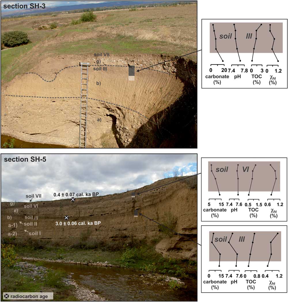
Our stratigraphic interpretations relied on identifying fluvial sedimentologic facies and paleosols in conjunction with geochronology. Paleosols indicate former stable geomorphological conditions in a floodplain without significant fluvial sedimentation, and are thus crucial elements of the fluvial stratigraphy (Faust et al., Reference Faust, Zielhofer, Baena-Escudero and Diaz del Olmo2004). To distinguish paleosols from possibly similar-looking sequences in fluvial depositional facies, we in part relied on 33 sample measurements. Our premise was that, for paleosols, carbonate and pH values should systematically decrease (in the up-profile direction), and values of total organic carbon (TOC) and frequency-dependent magnetic susceptibility (χfd) should increase. In contrast, fluvial depositional facies not altered by in-situ pedogenesis should show less systematic patterns of these properties (Fig. 4; cf. Zielhofer et al., Reference Zielhofer, Recio-Espejo, Nunez-Granados and Faust2009; Suchodoletz et al., Reference Suchodoletz, von, Menz, Kühn, Sukhishvili and Faust2015).
Carbonate contents were measured following Scheibler in an Eijkelkamp Calcimeter apparatus. Total organic carbon (TOC) was determined by measuring Ctotal with a Vario EL cube elemental analyzer, and subsequently subtracting inorganic carbon taken from carbonate measurements. pH values were measured using a pH-meter 196 (WTW). Frequency-dependent magnetic susceptibility (χfd) was measured using a Bartington MS3 magnetic susceptibility meter equipped with a MS2B dual frequency sensor (0.465 and 4.65 kHz), and detects mineral grains at the single domain/superparamagnetic border (<30 nm) mostly formed by pedogenesis (e.g., Torrent et al., Reference Torrent, Liu, Bloemendal and Barrón2007). For more analytical details the reader is referred to Suchodoletz et al. (Reference Suchodoletz, von, Menz, Kühn, Sukhishvili and Faust2015).
Furthermore, the grain size of 8 representative sediment samples from sections SH-3, SH-7, and SH-8 were measured (see Fig. 5 for locations of the samples). Prior to measurement with a laser-based Malvern Mastersizer S, carbonate was removed with 10 and 30% HCl, organic matter with 10 and 35 % H2O2, and the samples were dispersed in sodium pyrophosphate solution (Na4P2O7) followed by ultrasonic treatment for 45 minutes.
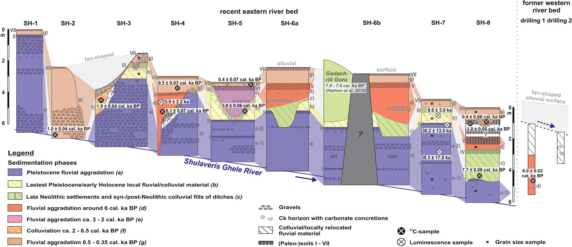
Figure 5 (color online) Schematic compilation of the investigated sections (SH-1–8) along the present eastern river bed, and of the hand drillings (drillings 1 and 2) in the former western river bed. For locations of the sites see Figure 2.
Numerical dating
The physical stratigraphy and supporting geochemical analyses were bolstered by numerical dating to give a compiled chronostratigraphy along the river. We applied two approaches:
-
(1) Radiocarbon dating of 12 charcoal pieces embedded into sediment layers and paleosols (see Fig. 5 and the Supplementary Material for GPS coordinates) was performed in the radiocarbon dating laboratories of Mannheim, Germany, Glasgow, UK, and Poznan, Poland. All ages were calibrated using Calpal_A, appyling the Intcal13-curve (Reimer et al., Reference Reimer, Bard, Bayliss, Beck, Blackwell, Bronk Ramsey and Buck2013). Preferably would have been non-charcoal organic matter (with less possibility of reworking), but such materials were not found.
-
(2) For luminescence dating, 6 samples were collected from sandy to loamy sediment layers at night (sample positions in the sections see Fig. 5 and the Figures in SOM-1), and processed under subdued red light (λ=640±20 nm) in the Bayreuth luminescence laboratory. After sieving with 200 and 90 μm mesh width, carbonate was destroyed using 10 and 30% HCl and organic matter with 10 and 37% H2O2, respectively. Since the mostly volcanic quartz of the study area is not appropriate for OSL-dating (Gamkrelidze, Reference Gamkrelidze2003; Tokuyasu et al., Reference Tokuyasu, Tanaka, Tsukamoto and Murray2010), K-feldspar was separated using sodium metatungstate monohydrate (2.58 and 2.53 g/cm3). Obtained coarse K-feldspar grains were mounted on aluminium cups (diameter=12 mm) using silicone oil. Due to generally dim luminescence intensities, sample aliquots of 3 mm were produced. Measurements were performed on a Risø-Reader TL/OSL-DA-15 (Thorn-EMI 9235QA photomultiplier; 90Sr/90Y β-source). We applied the single aliquot regeneration protocol (Murray and Wintle, Reference Murray and Wintle2000), including a hotbleach of 280°C after every regenation cycle to reduce recuperation. Stimulation was with infrared LEDs (infrared stimulated luminesence, IRSL), and wavelengths 390–450 nm were detected. No dependence of equivalent doses of preheat temperatures was found during tests. Thus, similar to Preusser (Reference Preusser2003), a preheat temperature of 270°C was chosen for equivalent and regenerated doses, and a cut-heat of 200°C for test doses. The first 1.5 s of the signal served to analyse the luminescence signal, and the last 100 s served as background. A recycling ratio larger±10% and recuperation >15 % were taken as rejection criteria for individual aliquots. A large scatter of individual De’s indicates incomplete bleaching during last sediment transport. Thus, we calculated the De’s used for age calculation from the lower part of the De-distribution based on the statistical approach of Juyal et al. (Reference Juyal, Chamyal, Bhandari, Bhushan and Singhvi2006) modified by Fuchs et al. (Reference Fuchs, Woda and Bürkert2007), using the simplified minimum age model of Galbraith et al. (Reference Galbraith, Roberts, Laslett, Yoshida and Olley1999). To correct for anomalous fading (Huntley and Lamothe, Reference Huntley and Lamothe2001), the g-value of sample L-119 was measured using three aliquots (3.2±1.9). Due to limited machine time and the quite small and geologically homogeneous catchment area, this value was used for all samples.
Dose rates were measured with low-level gamma spectrometry at the Felsenkeller-laboratory of the VKTA Rossendorf in Dresden, Germany, or with thick-source-α–counting (U and Th) and ICPMS (K) at the University of Bayreuth. Since all outcrops had been open for an uncertain period, causing desiccation of the sediments, we inferred a water content of 10±10% for sample L-120 with a sandy grain size. For the orther loamy-textured samples, we inferred a water content of 20±10%. These values should encompass the average water content throughout the burial history (Fuchs, Reference Fuchs2001). We assumed an internal K-content of 12.5% (Dütsch and Krbetschek, Reference Dütsch and Krbetschek1997), and an a-value of 0.07±0.02 (Preusser, Reference Preusser2003). Measurement parameters are given in Table 1.
Table 1 Measurement parameters and results of luminescence dating.

1 Based on the rejection criteria: (i) recycling ratio larger±10% and (ii) recuperation >15%.
2 U, Th, and K measured with low-level gamma spectrometry.
3 U and Th measured with thick-source-α-counting (42 mm), and K measured with ICPMS.
RESULTS
Stratigraphy of the sections
The mapped stratigraphies in conjunction with the analyses supporting paleosol identification (Fig. 4) generally show a consistent sequence that can be correlated between several sections along the present eastern river bed (Fig. 5). Specifically, we identified seven separate episodes of sedimentation (a–g), in part separated stratigraphically by seven paleosols (I–VII). Today, all sediments are deeply incised up to 7 m. The details of the episodes of sedimentation and paleosols are listed in Table 2, and detailed stratigraphies of the sections including interpretations of the sedimentary analyses can be found in the Supporting Online Material (SOM).
Table 2 Detailed information on late Quaternary sedimentation phases and (paleo-) soils found along the present eastern river bed of the lower Shulaveris Ghele River.

*In the upstream sections (SH-1, SH-3, and SH-4), the sediments of phase (a) are much more gravelly than downstream and are not divided by soil I.
Drilling 1, with a depth of 5 m, was located in the upstream part of the former western river bed, and mostly fluvial sand fining upwards was found in its lower part. This material is covered by 2-m-thick almost pebble-free loamy sediments that were interpreted as local fluvio-colluvial material. Charcoal was found throughout the drilling. Drilling 2, with a depth of 2 m, was located in the downstream part of the former western river course about 100 m upstream of the small alluvial fan. Basal sandy loam fines upwards and resembles the upper material of drilling 1. Vertic cambisols are found on top of both drillings, underlain by a Ck horizon in drilling 2.
Numerical dating
All radiocarbon samples (Table 3) gave Holocene ages between 7.74±0.06 cal ka BP (sample MAMS-17738) and 0.35±0.07 cal ka BP (sample Poz-40474). Given their positions above younger stratigraphical units, the ages of samples MAMS-17459 (4.8±0.07 cal ka BP, section SH-5) and MAMS-17738 (7.7±0.04 cal ka BP, section SH-6b) must be from incorporation of older charcoal into younger sediments (Table 3; Lang and Hönscheid, Reference Lang and Hönscheid1999). Thus, they are neither shown in Figure 4 and 5. nor further discussed in the text.
Table 3 Results of radiocarbon dating of charcoal pieces.

*POZ, Poznan Radiocarbon Laboratory; MAMS, Mannheim Radiocarbon Laboratory; SUERC, Scottish Universities Environmental Research Centre, Glasgow.
The IRSL-luminescence ages (Table 1) range between late Pleistocene (38.3±17.0 ka, sample L-110) and mid-Holocene (5.9±2.2 ka, sample L-118). All samples showed radioactive equilibrium. Apart from sample L-150 with linear signal growth, the samples showed exponential growth curves. Due to the large error of the applied g-value, the ages show rather large error bars after fading correction. Furthermore, the applied fading correction after Huntley and Lamothe (Reference Huntley and Lamothe2001) generally only works for samples with linear growth. However, because IRSL is the only luminescence dating technique appropriate in this volcanic environment, these are the ages we have to work with, but they should be regarded as approximate. Given their positions above younger stratigraphical units, the ages of samples L-119 (6.0±2.0 ka, section SH-5) and L-120 (10.9±3.2 ka, section SH-6a) must be too old, possibly because of insufficient bleaching that often occurs in fluvial environments (Table 1; Rittenour, Reference Rittenour2008). Thus, they are neither shown in Figures 4 and 5 nor further discussed in the text.
DISCUSSION
Late Quaternary fluvial dynamics and landscape evolution at the lower Shulaveris Ghele River
By combining the compiled stratigraphy and numerical dating, late Quaternary fluvial dynamics and landscape evolution along the lower Shulaveris Ghele River could be reconstructed as follows (Fig. 5 and 6).
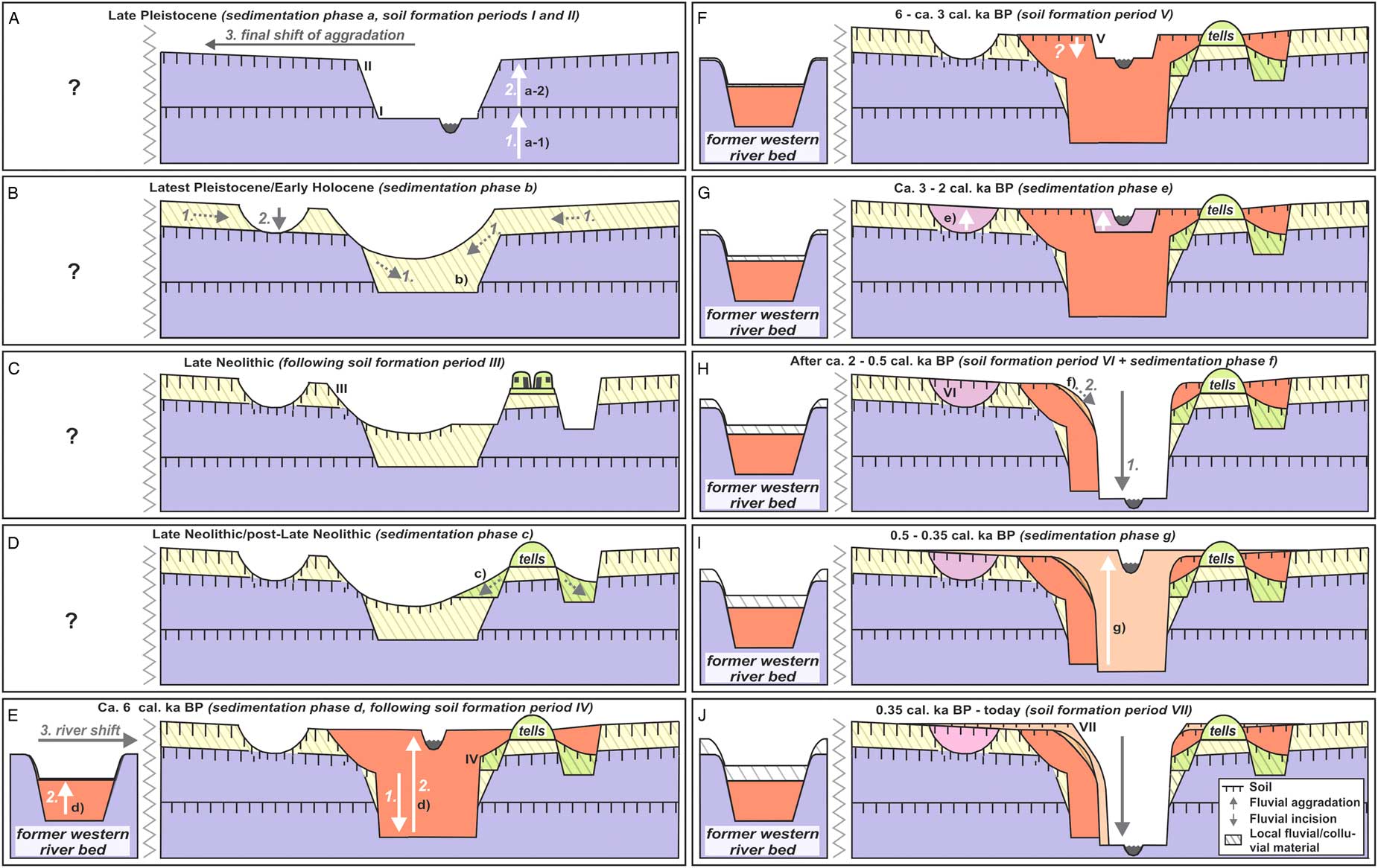
Figure 6 (color online) Late Quaternary landscape development along the lower Shulaveris Ghele River. Colours and symbols used for the sediments of the different phases are taken from Figure 5.
Late Pleistocene (Fig. 6A)
Fluvial sediments fining downstream were aggraded along the present eastern course (sedimentation phase a). Similar sediments were also observed in the central part of the former alluvial surface in an outcrop at the scarp with the Khrami valley (see Fig. 2 for location). Thus, the surface was apparently formed by fan-like fluvial aggradation. After leaving the confined valley in the Lesser Caucasus, the river aggraded large quantities of sediments as sheets or stream channel fillings on a radial surface. The fining downstream indicates less stream channel fillings but more sheetflood deposits due to less fluvial energy in that peripheral region (Bull, Reference Bull1972). Consequently, the larger preservation potential allowed preservation of intercalated soil I only in that part of the surface. This soil indicates geomorphic stability due to incision, less frequent flooding, and/or shifting aggradation. Sediments of sub-phase (a-2), deposited above soil I, were IRSL-dated between 38.3±17.0 ka (L-110) and 30.2±13.5 ka (L-14). Following this, soil II was formed, that is, exposed in the downstream part of the surface. The apparent absence of river sediments along the present eastern river course between about 30 ka and mid-Holocene may indicate river incision and/or a shift of fluvial sedimentation onto a more western part of the alluvial surface, allowing formation of soil II.
Latest Pleistocene/early Holocene (Fig. 6B)
Along the present eastern river course, soil II is covered by mostly gravel-free loam (sedimentation phase b). Given missing gravel layers and band and a very similar grain size with sediments of preceding phase (a) (Fig. 7), these sediments were probably derived from the latter and deposited by local fluvio-colluvial processes. A Ck horizon below soil II in section SH-6b indicates a longer stable period without sedimentation but soil formation following phase (a). Thus, phase (b) must have started some millenia after about 30 ka. In section SH-7 its sediments were IRSL-dated to 8.6±3.0 ka (L-150). However, a well-developed Ck horizon demonstrates intensive development of soil III that had formed on top of these sediments. Thus, soil III must have formed during several millenia so that the IRSL-age probably dates the very end of phase (b). Linked with regional fluvial incision around the Pleistocene/Holocene transition (Suchodoletz et al., Reference Suchodoletz, von, Menz, Kühn, Sukhishvili and Faust2015, Reference Suchodoletz, von, Gärtner, Hoth, Umlauft, Sukhishvili and Faust2016; Ollivier et al., Reference Ollivier, Fontugne and Lyonnet2015, Reference Ollivier, Fontugne, Lyonnet and Chataigner2016), the Khrami River was also incised, forming the scarp between the alluvial surface and the Khrami valley. This must have led to incision of the former western river course, causing final abandonment of the fan-shaped alluvial surface. The observed incision of sediments of phase (b) prior to formation of soil III was possibly also linked with that process.
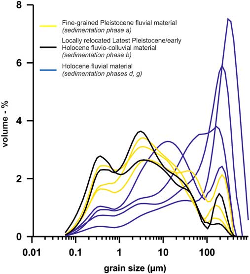
Figure 7 (color online) Results of selected grain size analyses from sections SH-3, SH-7, and SH-8. The locations of the samples in the stratigraphies can be seen in Figure 5.
Late Neolithic period (Fig. 6C)
During the eighth millenium BP, the settlements Imiris and Gadachrili Gora were constructed at the edge of the present eastern river course, where an inactive valley form must have been preserved. Reported radiocarbon ages for Gadachrili Gora vary between 7.9 and 7.6 cal ka BP (Hamon et al., Reference Hamon, Jalabadze, Agapishvili, Baudouin, Koridze and Messager2016; Kvavadze et al., Reference Kvavadze, Jalabadze and Shakulashvili2010), and a radiocarbon age of Imiris Gora gave 7.2±0.15 cal ka BP (Kiguradze, Reference Kiguradze1986).
Late Neolithic/post-late Neolithic period (Fig. 6D)
The Neolithic ditches were filled up with loamy archaeosediments (sedimentation phase c). Charcoal from these sediments was radiocarbon dated to 7.7±0.06 cal ka BP (Poz-40477), falling into the settlement period of Gadachrili Gora. However, colluvial filling of the ditches probably started/resumed after the late Neolithic period, so this age possibly slightly overestimates sediment deposition. The sediments of phase (c) were overprinted by weakly developed soil IV.
Around 6 cal ka BP (Fig. 6E)
Charcoal from coarse sandy river sediments from drilling 1 in the western former river bed were radiocarbon-dated to 6.0±0.03 cal ka BP (MAMS-17458). Overlying local fluvio-colluvial sediments were also found in drilling 2 about 2 km downstream (Fig. 2). Thus, the radiocarbon age apparently dates the last river activity in that river bed, where subsequently only local fluvio-colluvial processes occurred. A longer inactive period of the western river bed is also supported by a well-developed Ck horizon below the recent soil in drilling 2, demonstrating long-lasting soil formation until today. The low-energy local fluvio-colluvial processes could not incise the Khrami terrace down to the recent Khrami channel, i.e., the recent erosion base. Instead, the small alluvial fan at the outlet of the former western river bed was aggraded (Fig. 3B).
For the now-active present eastern river course, a radiocarbon age of 6.1±0.07 cal ka BP (MAMS-17460) and an IRSL age of 5.9±2.2 ka (L-118) were obtained from gravelly-to-loamy river channel sediments in section SH-4. Thus, following a long inactive period, fluvial aggradation (sedimentation phase d) apparently restarted along that river bed during that time. The measured grain size of sediments deposited since then is much coarser than that of phases (a) and (b) (Fig. 7), and numerous gravel layers and bands are observed. Similar gravelly to loamy channel sediments cover the post-Neolithic archaeosediments of phase (c) in sections SH-6a, SH-6b, and SH-8. Because there is only slight evidence of soil formation between these sediments and those of phase (c) (soil IV; Fig. 5), the former must have been deposited quite shortly after the late Neolithic period. Thus, they were also classified into sedimentation phase (d).
Between about 6 and 3 cal ka BP (Fig. 6F)
Formation of soil V and perhaps some incision of the present eastern river bed occurred, and no fluvial sediments originate from this period.
Between about 3 and 2 cal ka BP (Fig. 6G)
Gravelly to loamy channel sediments were aggraded along the present eastern river bed (sedimentation phase e). The timing of aggradation is indicated by (1) the radiocarbon age of 3.0±0.06 cal ka BP of charcoal from the upper part of underlying soil III in section SH-5 (Poz-40473); (2) a radiocarbon age of 1.9±0.04 cal ka BP from colluvial sediments of following phase (f); and (3) the well-developed paleosol VI in section SH-5 that separates the sediments of phases (e) and (g), demonstrating a significant time gap between both phases (Fig. 5).
About 2 – 0.5 cal ka BP (Fig. 6H):
Strong incision of the present eastern river bed must have occurred at the beginning of this period, probably allowing formation of soil VI. According to the radiocarbon age of 1.9±0.04 cal ka BP (SUERC-38291) of charcoal from a colluvial deposit in section SH-3, this also allowed colluviation along the present eastern river bed (sedimentation period f). No fluvial sediments originate from this period.
About 0.5 – 0.35 cal ka BP (Fig. 6I)
Intensive gravelly to sandy fluvial aggradation along the present eastern river bed spilled over on the adjacent surface (sedimentation phase g). Radiocarbon ages of these sediments are 0.48±0.03 cal ka BP (SUERC-38292, section SH-4), 0.37±0.06 cal ka BP (Poz-40480, section SH-8), and 0.35±0.07 cal ka BP (Poz-40474, section SH-5). Their base was radiocarbon dated to 1.0±0.04 cal ka BP (Poz-40472, section SH-2) and charcoal from the soil underlying these sediments in section SH-8 gave an age of 1.0±0.05 cal ka BP (Poz-40478). This demonstrates still strong incision of the river about 1 cal ka BP and a later start of significant aggradation.
After about 0.35 cal ka BP – today (Fig. 6J)
During this time the present eastern river bed was incised by up to 7 m, allowing formation of soil VII.
Possible controls of the late Quaternary dynamics of the Shulaveris Ghele River
In the following, we compare our fluvial record with a similar study carried out ca. 10 km to the northeast along the lower Algeti River (Suchodoletz et al., Reference Suchodoletz, von, Menz, Kühn, Sukhishvili and Faust2015), as well as with other regional paleoenvironmental and historical studies (Fig. 8).
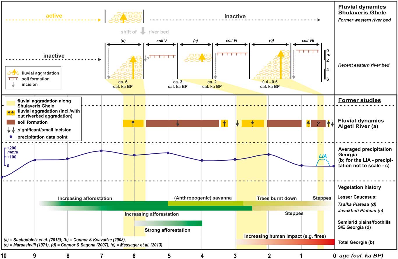
Figure 8 (color online) Comparison of the Holocene fluvial dynamics of the lower Shulaveris Ghele River with other regional paleoenvironmental records. Shadowed areas indicate periods of fluvial aggradation along the lower Shulaveris Ghele River, and according to information given by Maruashvili (Reference Maruashvili1971) the Little Ice Age (LIA) was also shown as a humid period whereof the duration was taken from Mann (Reference Mann2002).
Besides gravels, the late Pleistocene fan-shaped alluvial surface is largely formed by sand and silt (Fig. 7). The later sub-phase (a-2) was dated between about 40 and 30 ka. Intensive aggradation of fine sandy and silty sediments is also known from other regional rivers between about 42 and 20 ka (Suchodoletz et al., Reference Suchodoletz, von, Gärtner, Hoth, Umlauft, Sukhishvili and Faust2016). Similar to neighbouring regions of Eurasia and Iran (Dodonov et al., Reference Dodonov, Zhou, Markovac, Tchepalygac, Trubikhina, Aleksandrovski and Simakova2006; Vlaminck et al., Reference Vlaminck, Kehl, Lauer, Shahriari, Sharifi, Eckmeier, Lehndorff, Khormali and Frechen2016), late Pleistocene loess sedimentation is also described for northern Armenia (Wolf et al., Reference Wolf, Baumgart, Meszner, Fülling, Haubold, Sahakyan, Meliksetian and Faust2016). Thus, the large proportion of silt in regional fluvial sediments of late Pleistocene age can possibly also be explained with aeolian input.
The possible shift of fluvial activity towards the western part of the alluvial surface was followed by a stable period with soil formation along the present eastern river bed. Subsequently, during latest Pleistocene/early Holocene loamy sediments of phase (a) were relocated by local fluvio-colluvial processes (sedimentation phase b). Regional pollen studies indicate a significant precipitation increase between 10 and 8 ka (Connor and Kvavadze, Reference Connor and Kvavadze2008; Joannin et al., Reference Joannin, Ali, Ollivier, Roiron, Peyron, Chevaux, Nahapetyan, Tozalakyan, Karakhanyan and Chataigner2014). Thus, before that period, the semiarid to arid landscape was only sparsely vegetated and largely instable, which allowed sediment mobilisation and redeposition. However, it cannot be resolved whether these processes correlated with short-term climatic events such as around 10.3 and 8.2 ka as supposed for slope deposits in Europe or Anatolia (Dreibrodt et al., Reference Dreibrodt, Lomax, Nelle, Lubos, Fischer, Mitsuov and Reiss2010; Vincent et al., Reference Vincent, Lord, Telfer and Wilson2010; Dreibrodt et al., Reference Dreibrodt, Lubos, Lomax, Sipos, Schroedter and Nelle2014).
Following deep incision of the regional rivers around the Pleistocene/Holocene transition (Suchodoletz et al., Reference Suchodoletz, von, Menz, Kühn, Sukhishvili and Faust2015, Reference Suchodoletz, von, Gärtner, Hoth, Umlauft, Sukhishvili and Faust2016; Ollivier et al., Reference Ollivier, Fontugne and Lyonnet2015, Reference Ollivier, Fontugne, Lyonnet and Chataigner2016), no aggradation was recorded along the neighbouring Algeti River until about 6 ka, whereas no data are available for the Shulaveris Ghele (Fig. 8). Either there was no significant fluvial aggradation, or aggraded sediments were swept out during following periods. As noted earlier, precipitation significantly increased between 10 and 8 ka (Connor and Kvavadze, Reference Connor and Kvavadze2008; Joannin et al., Reference Joannin, Ali, Ollivier, Roiron, Peyron, Chevaux, Nahapetyan, Tozalakyan, Karakhanyan and Chataigner2014), and the higher parts of the Lesser Caucasus were intensively afforested (Connor and Sagona, Reference Connor and Sagona2007; Messager et al., Reference Messager, Belmecheri, Grafenstein, Nomade, Voinchet, Ollivier, Mgeladze, Lordkipanidze, Mazuy and Moreau2013). Although the lowlands and plains were still covered by dry savannas, dense gallery and riparian forests were found along the rivers (Connor and Sagona, Reference Connor and Sagona2007; Chataigner et al., Reference Chataigner, Badalyan and Arimura2014; Lyonnet et al., Reference Lyonnet, Guliyev, Bouquet, Bruley-Chabot, Samzun, Pecqueur and Jovenet2016). This indicates a largely stabilized landscape resulting in relatively weak fluvial dynamics without significant aggradation. Accordingly, Shulaveri-Shomutepe settlements in western Azerbaijan were built on pre-Neolithic alluvial fans that were covered by new sediments only since about 5.2 ka (Ollivier et al., Reference Ollivier, Fontugne, Lyonnet and Chataigner2016).
Both the Algeti and Shulaveris Ghele rivers aggraded around 6 ka, when the climate was relatively cool (Connor and Sagona, Reference Connor and Sagona2007) and dry (Fig. 8; Connor and Kvavadze, Reference Connor and Kvavadze2008). Furthermore, their semiarid lower catchments were still not forested (Fig. 8; Connor and Sagona, Reference Connor and Sagona2007) so that sediment mobilization was still easily possible here. Thus, a climatic deterioration affecting a partly fragile landscape could possibly have caused middle Holocene aggradation (Suchodoletz et al., Reference Suchodoletz, von, Menz, Kühn, Sukhishvili and Faust2015).
Between about 3 and 2 ka, Algeti and the Shulaveris Ghele River aggraded again. Human impact on the regional vegetation significantly increased during that period (Connor and Kvavadze, Reference Connor and Kvavadze2008), and especially the upper catchments in the Lesser Caucasus were largely deforested (Connor and Sagona, Reference Connor and Sagona2007; Messager et al., Reference Messager, Belmecheri, Grafenstein, Nomade, Voinchet, Ollivier, Mgeladze, Lordkipanidze, Mazuy and Moreau2013). This could have mobilized large quantities of sediment, causing the observed aggradation.
During the last 1 ka, both rivers showed similarities and differences. Sedimentation along the Algeti River between 0.77 and 0.72 ka was possibly caused by intensive deforestation during a high cultural phase of the Georgian state (Lordkipanidze, Reference Lordkipanidze2002). The Little Ice Age (LIA) between the fifteenth century and AD 1850 (Mann, Reference Mann2002) was reported as a more humid period in the southern Caucasus (Maruashvili, Reference Maruashvili1971), which could be a possible cause of fluvial aggradation. Aggradation occurred along the Shulaveris Ghele between 0.5 and 0.35 ka, and along the Algeti between 0.2 and 0.15 ka. Although the latter period could also be caused by a Persian invasion with large-scale destruction of cities and agricultural land (Lordkipanidze, Reference Lordkipanidze2002), its timing at the end of the LIA could also indicate a climatic cause. Likewise, rivers in the European Alps and the northwest Mediterranean basin showed increased activity linked with more humid conditions at least during parts of the LIA (Wirth et al., Reference Wirth, Glur, Gilli and Anselmetti2013; Benito et al., Reference Benito, Macklin, Zielhofer, Jones and Machado2015).
Altogether, similar fluvial patterns of both rivers were probably caused by regional paleoenvironmental signals, and existing differences could possibly be explained with different tectonic settings, small-scale variations of natural or anthropogenic conditions, or different internal thresholds of the rivers (Leopold et al., Reference Leopold, Wolman and Miller1964). Comparing our fluvial aggradation periods of ~6 ka, 3–2 ka, and since about 1 ka with neighbouring regions, they are very different from the eastern Mediterranean basin where flooding occurred 8–7 ka, around 4 ka, and since about 2 cal ka BP (Fig. 1 inset; Benito et al., Reference Benito, Macklin, Zielhofer, Jones and Machado2015). For the Pasinler Basin in eastern Anatolia, overbank sedimentation was described between 8.6 and 5.7 ka, and fluvial aggradation resumed since about 1 ka (Fig. 1, inset; Collins et al., Reference Collins, Rust, Bayraktutan and Turner2005). Due to dating uncertainties, the first sedimentaton period could not be correlated with aggradation in our study area, but the second period resembles our last aggradation period. Thus, the fluvial dynamics in the southern Caucasus apparently shows some similariaties with eastern Anatolia but strongly differ from those of the eastern Mediterranean basin. Whereas both eastern Anatolia and southern Caucasus show a main precipitation peak during May, the eastern Mediterranean basin is characterized by maximal winter precipitation and discharge, which could explain the very different fluvial patterns.
Late Neolithic settlement activity and evolution of the surrounding landscape
Our study suggests that the lower Shulaveris Ghele River did not flow in its present eastern bed during the time of the Shulaveri-Shomutepe culture, and only came back about 6 cal ka BP. This finding is based on: (1) missing fluvial sediments along the present eastern river course between about 30 ka and 6 ka; (2) a well-developed former western river bed that is incised into the fan-shaped alluvial surface and ends at a 9-m-high terrace of the Khrami River. This river bed must have been active during the Pleistocene/Holocene transition when the alluvial surface was incised, and fluvial activity must have persisted until about 6 ka, when the 9 m Khrami terrace was formed (Hans von Suchodoletz, unpublished data); (3) fluvial sediments in the former western river bed that apparently represent the last fluvial activity and are concomitant with the restart of fluvial activity in the present eastern river bed about 6 ka.
Thus, although located next to the present eastern river bed, the late Neolithic settlements Imiris and Gadachrili Gora did not have direct access to the river. Accordingly, their location could not be explained with the search for direct water access as was supposed by Hamon et al. (Reference Hamon, Jalabadze, Agapishvili, Baudouin, Koridze and Messager2016). Instead, similar to Dangreulis and Shulaveris Gora, the settlements were constructed some kilometers away from any river. Likewise, the late Neolithic settlement Arukhlo (north of the Mashavera River; Fig. 2) also was constructed at an elevated position in a distance of about 1 km from the neighbouring rivers. The lack of direct water access and of (yet discovered) wells suggests that water supply of Imiris and Gadachrili Gora could have been facilitated by water management systems similar to those described for other Neolithic cultures in semi-humid to arid regions of the Near East (Gillmore et al., Reference Gillmore, Coningham, Fazeli, Young, Magshoudi, Batt and Rusworth2009; Mithen, Reference Mithen2010). These could have been freshwater canals, as was hypothesized for a canal that was excavated next to Imiris Gora (Javakhishvili, Reference Javakhishvili1973), or ditches that served as water reservoirs, as was formerly assumed for Arukhlo (Kiguradze, Reference Kiguradze1986; Hansen et al., Reference Hansen, Mirtskhulava and Bastert-Lamprichs2007). The valley form at the place of the present eastern river bed, apparently preserved between the late Pleistocene and middle Holocene, could have facilitated the construction of canals. Interestingly, in contrast to Shulaveris Gora that was located far from any preserved valley (Fig. 2), no water reservoirs are described for Imiris and Gadachrili Gora (Javakhishvili, Reference Javakhishvili1973; Hamon et al., Reference Hamon, Jalabadze, Agapishvili, Baudouin, Koridze and Messager2016). Looking further into the archaeological record of Gadachrili Gora, the absence of river activity in the present eastern river bed prior to about 6 ka excludes varying river activity as a cause of the diachronically varying late Neolithic settlement organization as was supposed by Hamon et al. (Reference Hamon, Jalabadze, Agapishvili, Baudouin, Koridze and Messager2016).
In the following, we will discuss potential causes for the Holocene river channel migration that is a key feature to understanding the late Neolithic landscape context of the study area.
Tectonically-induced lateral ground tilting can cause river channel migrations (Holbrook and Schumm, Reference Holbrook and Schumm1999; Sahu et al., Reference Sahu, Raju and Saha2010). However, significant faults are only found about 15 km to the south in the Lesser Causasus (Gamkrelidze, Reference Gamkrelidze2003) and, unlike some parts of the Lesser and Greater Caucasus, no earthquakes were recorded significantly north of these faults, at least during the twentieth century (Berberyan, 1997; Suchodoletz et al., Reference Suchodoletz, von, Gärtner, Hoth, Umlauft, Sukhishvili and Faust2016). Although only covering a relatively short period, these data and missing large faults indicate that the study area must have been tectonically relatively quiet, at least at the Holocene time scale. Furthermore, the suggested switching of fluvial aggradation from east to west and back again argues against a continuous tilting trend, making a tectonic cause for the river channel migration unlikely.
The channel migration around 6 ka falls into the transition between the Chalcolithic Sioni and the early Bronze Kura Araxes cultures in eastern Georgia (Kiguradze, Reference Kiguradze2000; Connor and Sagona, Reference Connor and Sagona2007). Sioni settlement is documented about 15–20 km to the south (Nebieridze, Reference Nebieridze2010), and Kura Araxes settlements are found in the study area at the scarp between alluvial surface and Khrami valley (Fig. 2; Jalabadze, M., personal communication, 2016). This demonstrates human presence during that period, so an anthropogenic cause for the river channel migration such as direct manipulation of the river course cannot totally be excluded.
Strong fluvial aggradation levels the deepened form of river channels, leading to instability of the river courses since rivers will preferably drain into the deepest geomorphic form (Wells and Dorr, Reference Wells and Dorr1987). The channel migration occurred during a regional fluvial aggradation period (period d), and thus we think that this was the most likely cause. During this period, the river obviously re-used a preserved valley form in the eastern part of the alluvial surface. Given the preserved former western river bed, depending on its autogenic sedimentation dynamics, the lower Shulaveris Ghele River can apparently switch between two possible modes during aggradation periods, i.e., choose one of the two inherited river beds (Phillips, Reference Phillips2014).
CONCLUSIONS
Similar to other regional rivers, the lower Shulaveris Ghele River in southeast Georgia aggraded large quantities of mostly fine-grained sediments during the late Pleistocene. These were possibly partly derived from reworked aeolian loess. By comparing the Holocene fluvial dynamics with the neighbouring Algeti River, despite some differences three main aggradation periods indicate enhanced fluvial activity around 6 ka, 3–2, and since about 1 ka. In contrast, prior to about 6 ka, no fluvial aggradation was observed, which possibly indicates weak fluvial activity in a largely stabilized landscape. We assume that fluvial activity was linked to vegetation dynamics that were controlled by regional climatic and/or anthropogenic factors, and for the LIA possibly also to direct climatic forcing. Differences between both rivers could possibly be explained with different tectonic settings, small-scale variations of natural or anthropogenic conditions, or different internal thresholds of the rivers. Whereas our study suggests a completely different fluvial pattern in the southern Caucasus compared with the eastern Mediterranen basin, some similarities appear with eastern Anatolia. Since this conclusion is based on the investigation of just two rivers, further research is needed to better understand the largely independent flooding pattern in the southern Caucasus during the late Quaternary.
Our study suggests that the lower Shulaveris Ghele River did not use its present eastern bed between about 30 and 6 ka. Thus, the two late Neolithic settlements that are located next to the present eastern river bed were originally not built close to that river. Accordingly, their archaeological record cannot be explained with former river activity, and the lack of direct water access, (yet detected) wells and water reservoirs might suggest water management systems similar to other Neolithic cultures in semi-humid to arid regions of the Near East.
ACKNOWLEDGMENTS
The project was financially supported by the Deutsche Forschungsgemeinschaft (project SU 491/5-1). We are very grateful to Ludwig Zöller and Manfred Fischer (University of Bayreuth) for providing the grain size and luminescence facilities and help during luminescence measurements. We thank Ulrich Göres (Dresden) and Marco Holzheu, Birgit Schneider, Katja Pöhlmann, and Julia Jäger (all Leipzig) for support during field work and sedimentary analyses. Furthermore, we are indebted to Mikheil Elashvili and Lasha Sukhishvili (Tbilisi) for logistical support of fieldwork and data supply. Finally, we thank associate editor Jim O’Connor as well as Adam Forte and an anonymous reviewer for their helpful evaluation of the manuscript.
Supplementary material
For supplementary material/s referred to in this article, please visit https://doi.org/10.1017/qua.2017.80


