INTRODUCTION
Qinghai Lake, located at the northeastern corner of the Tibetan Plateau, is the largest inland water body in China in terms of surface area. The altitude of the lake surface is ~3194 m asl (measured in 2013). The lake (Fig. 1) is surrounded by Amuniniku Mountain, Datong Mountain, Riyue Mountain, and Qinghainan Mountain, which form the boundaries of this inland basin. The topography decreases in altitude from northwest to southeast, and the lake is in the southeastern part of the basin. Located at a “climatic triple junction” of the East Asian monsoon, Indian monsoon, and the westerly jet stream (Benn and Owen, Reference Benn and Owen1998; An et al., Reference An, Colman and Zhou2012), Qinghai Lake basin (Fig. 1) also lies in the transitional belt of the eastern monsoonal humid area and the northwestern arid area (An et al., Reference An, Wang and Shen2006), as well as in the transition zone between the Qinghai-Tibetan Plateau and the Chinese Loess Plateau (Chen et al., Reference Chen, Bowler and Kelts1990). Its unique geographical location makes Qinghai Lake basin highly sensitive to climatic changes, especially monsoon activity, and the lacustrine deposits contain abundant information about the regional environmental history. In the past several decades, research on climatic proxies from sediment cores from Qinghai Lake have revealed the occurrence of pronounced environmental fluctuations during the Holocene (e.g., Du et al., Reference Du, Kong and Shan1989; Lister et al., Reference Lister, Kelts and Chen1991; Ji et al., Reference Ji, Shen and William2005; Liu et al., Reference Liu, Shen and Wang2002, Reference Liu, Wang and Shen2003, Reference Liu, Shen and Wang2007; Shen et al., Reference Shen, Liu and Matsumoto2005a, Reference Shen, Liu and Wang2005b; Yu and Kelts, Reference Yu and Kelts2002; An et al., Reference An, Colman and Zhou2012).

Figure 1 Setting and locations: (a) location of Qinghai Lake basin (red closed curve) and atmospheric circulation systems; (b) Qinghai Lake basin; (c) location of former Picea charcoal sites and the studied sections; and (d) three-dimensional graphic of the location of the CGL and SDT sections. EASM, East Asian monsoon; IM, Indian monsoon; WJS, westerly jet stream. (For interpretation of the references to color in this figure legend, the reader is referred to the web version of this article.)
The reconstruction of paleo-vegetation is a focus of paleoclimatic research, and many pollen-based studies of Holocene vegetation changes within the Qinghai Lake area have been produced (Yang and Jiang, Reference Yang and Jiang1965; Du et al., Reference Du, Kong and Shan1989; Zheng et al., Reference Zheng, Zhao and Ge1995; Liu et al., Reference Liu, Shen and Wang2002; Shen et al., Reference Shen, Liu and Matsumoto2005a, Reference Shen, Liu and Wang2005b; Hou et al., Reference Hou, Wei and E2013). Pollen results are relatively consistent in suggesting the existence of forest, even broadleaf forest, during the early-middle Holocene in Qinghai Lake basin, although there is no forest there today. In contrast to pollen, plant macrofossils can often be identified to the species level, which avoids some of the problems of the low level of taxonomic identification in pollen analysis (Lowe and Walker, 2010). In addition, plant macrofossils have a low probability of long-distance transport, and thus they can provide direct information about the local environment. Therefore, fossil wood has been an important proxy for terrestrial paleoclimatic and paleogeographic reconstruction (Tian et al., Reference Tian, Wang and Philippe2016).
Modern Qinghai Lake has a drainage area of 29,660 km2, and the vegetation is mainly montane shrubland, alpine steppe, and high-alpine meadows. Coniferous forest is currently the only forest in the Lake Qinghai area and is restricted to the deep valley of the Qieji River to the west of Qinghai Lake (Chen and Peng, Reference Chen and Peng1993). During fieldwork in 2015 and 2016, we found abundant woody debris and cones (Fig. 2) of spruce (Picea crassifolia Kom.) in the Dashuitang River valley and an unnamed valley to the east of Qinghai Lake basin, and this find, and its paleoenvironmental significance, is the focus of the present study.

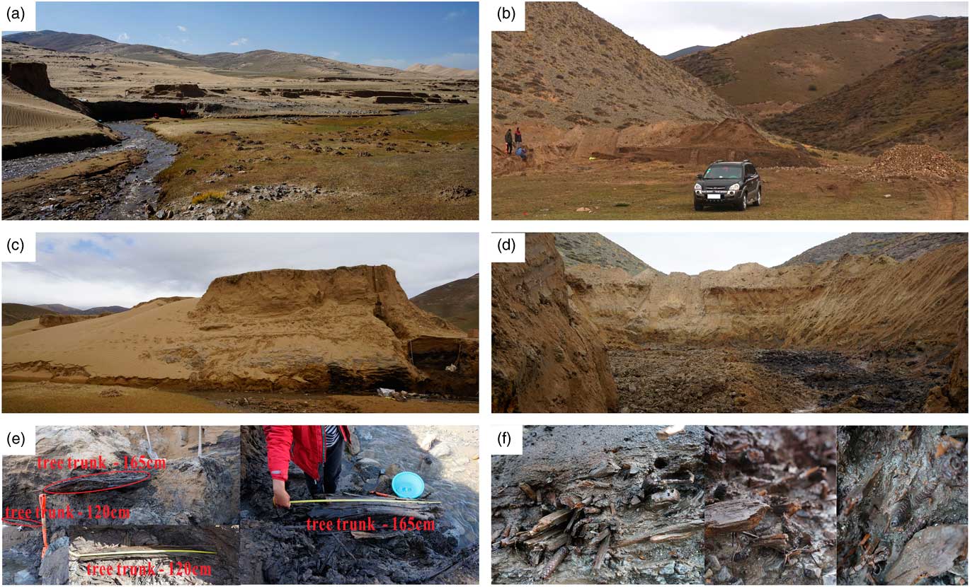
Figure 2 (color online) Modern environment of the CGL section and SDT section and photographs of buried wood and cones: (a) distant view of CGL section from the north side with Dashuitang River in the foreground; (b) distant view of SDT section from the west side; (c) close-ups from the west side showing the full view of CGL section; (d) close-ups from northwest side showing the full view of SDT section; (e) tree trunks buried in the strata, the one about 165 cm found in CGL section, and the other one found in the north side of CGL section; and (f) buried wood and cones of spruce in CGL section.
Modern environment of the study sites
The studied sections discussed in this paper are the CGL section (36°46′46″N, 100°51′33″E, altitude 3407 m asl) and the SDT section (36°47′46″N, 100°52′32″E, altitude 3482 m asl (Figs. 1 and 2). The CGL section is located on the left bank of the Dashuitang River, and the SDT section is located in the mountain pass of an unnamed valley; both sections are on the eastern edge of Hudong Sandy Land.
The Dashuitang River (Figs. 1d and 2), in the east part of Qinghai Lake basin, rises in the Riyue Mountain and disappears in Hudong Sandy Land after crossing a series of mountain valleys. The valley of the Dashuitang River is about 1 km wide, and the modern vegetation mainly consists of Leguminosae and Gramineae with no trees. Several mobile sand dunes are distributed at the base of the nearby mountains, and a widely exposed eolian-paleosol sequence occurs on the high ground. Sporadic residual fluvial-marsh deposits occur on the low-lying land. There is exposure of fluvial-lacustrine sediments with an area of ~0.1 km2 to the southeast of the CGL section, which suggests that the study sites were within a shallow lake or ponded environment during 9.7–4.1 ka (Fig. 3).

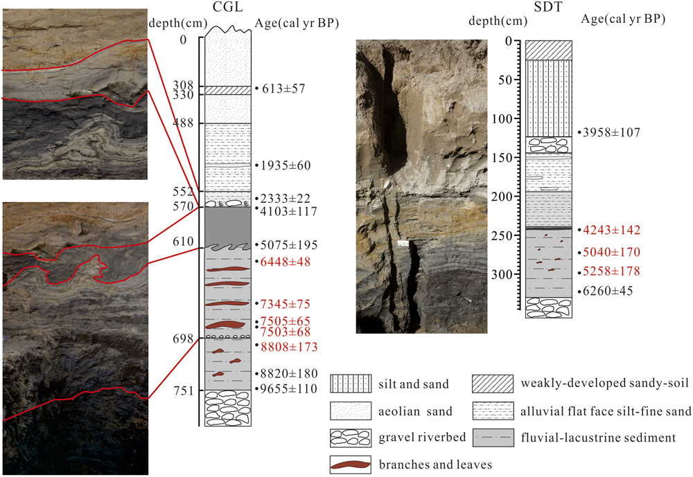
Figure 3 Stratigraphy and AMS 14C dates for the CGL section and SDT section. The ages in red are from wood fragments or cones. (For interpretation of the references to color in this figure legend, the reader is referred to the web version of this article.)
The modern vegetation of the unnamed valley where the SDT section is located is similar to that of Dashuitang River valley. There is a seasonal stream in the valley that also disappears in Hudong Sandy Land, flowing for ~500 m near the SDT section.
MATERIALS AND METHODS
In the Dashuitang River valley, 15 samples were obtained for accelerator mass spectrometry (AMS) 14C dating, including 13 samples from the CGL section and two samples of buried wood from the north and south sides of the section. The samples from the CGL section consisted of 5 organic-rich bulk sediment samples and 8 wood fragments. In addition, we selected 7 samples for AMS 14C dating from the SDT section, including 3 of wood debris, 1 spruce cone, and 3 samples of organic sediments. AMS 14C dating was conducted at the Beta Analytic Radiocarbon Dating Laboratory, and the pretreatment procedures can be found on the website of Beta Analytic (http://www.radiocarbon.com/ams-dating-sediments.htm). The Pretoria Calibration Procedure program (Talma and Vogel, Reference Talma and Vogel1993) was used for calendar calibrations. The calibration database used was IntCal13 (Reimer et al., Reference Reimer, Bard and Bayliss2013).
A total of 11 samples of woody debris and 4 cones were retained for later identification. Analysis of the anatomical structure and subsequent identification of the wood was undertaken at the Research Institute of Wood Industry, Chinese Academy of Forestry. First, the wood was softened with distilled water at a temperature of 60°C for 48 h. Subsequently, thin, transparent slices of wood tissue (with a thickness of about 10–20 μm) were cut accurately along the transverse plane, radial plane, and tangential plane for microscopic study. These slices were dyed with a biological reagent and then dehydrated, which rendered them translucent, and mounted. The structural characteristics of the transverse, radial, and tangential sections were then identified under an optical microscope.
RESULTS
Lithology of the study sections
The CGL section is 751 cm thick; river gravel occurs below 751 cm, fluvial-lacustrine sediments from 751 to 488 cm, and the upper 488 cm consist of eolian deposits. The lithology of the CGL section is described in detail in Table 1. Specifically, buried branches, leaves, and cones were found mainly within gray-black silt layers below 610 cm depth (see Figs. 2 and 3) and along the river, many branches and cones can be found overlying the ancient river gravel layer to the southwest and north of the CGL section. We also found two tree trunks: one was within the interval from 656 to 687 cm in the CGL section and was 165 cm in length and about 20 cm in diameter; and the other, on the north side of the CGL section, was 120 cm in length and 15 cm in diameter.
Table 1 Lithology of the CGL section.

The lithology of the SDT section is similar to that of the CGL section, and buried branches or cones were found mainly within gray-black silt layers from 240 to 300 cm depth (see Figs. 2 and 3), although the woody debris was less common and smaller than that in the CGL section. The SDT section is 328 cm thick; river gravel occurs below 328 cm, fluvial-lacustrine sediments from 328 to 148 cm, colluvial gravel from148 to 126 cm, and the upper 126 cm consist of silt and sand. The sediment composition of the upper 126 cm may be eolian, fluvial, or/and colluvial, and no buried branches or cones were found therein.
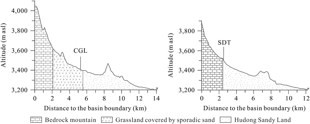
According to the information currently available, it is difficult to determine whether the spruce trees found in the CGL and SDT sections were in their growth position or were deposited downstream as driftwood. However, both sections are located at the eastern margin of Hudong Sandy Land, less than 6 km from the basin boundary (Fig. 4). Therefore, the wood debris found in the sections must have grown at or above the elevation of the section sites.

Figure 4 Location of the sections studied in relation to the basin boundary and modern lake.
Chronology
The results of AMS 14C dating are listed in Table 2. In the case of one sample, from 242 to 244 cm of the SDT section, dates were obtained on both organic sediments and wood charcoal. The dates are consistent, suggesting that the effects of “old carbon” error on the dates from organic sediments can be ignored. The ages from the CGL and SDT sections are all in stratigraphic order within the limits of the analytical error (Table 2).
Table 2 Results of radiocarbon dating of the wood fragments from the CGL and SDT sections.

It is noteworthy that there are two possible sedimentary hiatuses in the CGL section, one at ~570 cm and the other at ~698 cm. Large gravel clasts with a diameter of about 15 cm occurred at a depth of 570 cm in the section, and we speculate that they indicate a sedimentary hiatus. Moreover, the dating results (Fig. 3) confirm that a hiatus occurs from 4.0 to 2.5 ka. In addition, there are also small gravel clasts with diameters of ~2 mm from 696 to 698 cm. There is no obvious grain-size difference above and below 698 cm, but the sediments below 698 cm are blacker in color and contain fewer buried wood fragments than those above. The ages of buried wood above and below 698 cm are 6610±30 yr BP (686.5 cm, 7503±68 cal yr BP) and 7930±30 yr BP (698–718 cm, 8808±173 cal yr BP), respectively, with a significant age gap of more than 1000 yr. Thus, according to the dates and the lithology, there is a possible sedimentary hiatus at ~698 cm. The 8 ka event (Alley and Ágústsdóttir, Reference Alley and Ágústsdóttir2005) may be the likeliest explanation for this sedimentary hiatus, when the shallow lake or pond would have been desiccated under the cold and dry conditions, with the study area serving as a potential dust source. Although spruce debris dating to the 8 ka event was not found, the spruce remains appear to both predate and postdate this gap, suggesting that the 8 ka event was not responsible for the demise of the spruce trees.
According to the field investigation and dating results, the buried wood in the CGL section grew mainly during the interval from 9.7 to 6.5 ka, with the large trunks or branches mainly growing from 7.5 to 6.5 ka. In the SDT section, the spruce debris mainly occurred during 6.3–4.2 ka.
Identification of the woody debris and cones
The identification results (Fig. 5a–c) indicate that the buried wood is Picea sp. The anatomical features are as follows: growth rings distinct, the transition from earlywood to latewood gradual; bordered pits on radial cell wall in early wood uniseriate (occasionally biseriate); uniseriate and fusiform rays, ray tracheids present in both ray types, with dentate thickenings, spiral thickenings occasionally present; cross-field pitting piceoid; axial resin canals and radial ones both present.

Figure 5 (color online) Structure of the buried wood and cones: (a) cross section; (b) radial section; (c) tangential section; and (d) buried cones.
The buried cones (Fig. 5d) were identified as Picea crassifolia Kom. by Liu Quanru of the College of Life Science, Beijing Normal University. According to the wood anatomical structure and the identification of the cones, we conclude that the buried wood found in Qinghai Lake basin is Picea crassifolia Kom.
DISCUSSION
Paleo-vegetation significance of the buried wood debris in Qinghai Lake basin
The reconstruction of paleo-vegetation has long been an important aspect of paleoenvironmental research, but compared with the abundant research on the Holocene environment of Qinghai Lake basin, only a few pollen-based studies of vegetation change have been produced (Yang and Jiang, Reference Yang and Jiang1965; Du et al., Reference Du, Kong and Shan1989; Zheng et al., Reference Zheng, Zhao and Ge1995; Liu et al., Reference Liu, Shen and Wang2002; Shen et al., Reference Shen, Liu and Matsumoto2005a, Reference Shen, Liu and Wang2005b; Hou et al., Reference Hou, Wei and E2013). Yang and Jiang (Reference Yang and Jiang1965) initiated pollen analytical research on the lacustrine sediments of Qinghai Lake, but the analyses were of low stratigraphic resolution. Zheng et al. (Reference Zheng, Zhao and Ge1995) conducted pollen analyses of the Dashuitang section in the eastern part of Qinghai Lake; however, the pollen counts of 7 out of 8 samples were less than 200 grains, and thus are not statistically significant. Higher-resolution pollen analyses were conducted on cores QH85-14C (Du et al., Reference Du, Kong and Shan1989) and QH2000 (Liu et al., Reference Liu, Shen and Wang2002; Shen et al., Reference Shen, Liu and Matsumoto2005a, Reference Shen, Liu and Wangb). Based on 5 14C dates, Du et al. (Reference Du, Kong and Shan1989) conducted pollen analyses of 47 samples and concluded that deciduous broadleaf and coniferous mixed forest was present in the Qinghai Lake area during 8–3.5 ka and that the forest components were mainly Picea, Pinus, Abies, and Betula. Using a chronology provided by six AMS 14C dates, Liu et al. (Reference Liu, Shen and Wang2002) and Shen et al. (Reference Shen, Liu and Matsumoto2005a, Reference Shen, Liu and Wang2005b) reconstructed the paleoclimate and paleoenvironment of Qinghai Lake based on pollen and other proxies. They found that the arboreal pollen was dominated by Pinus, Picea, and Abies during 9.1–5.8 ka and that the vegetation consisted of forest steppe (or forest); from 5.8 to 2.06 ka, the forest vegetation declined, and the landscape changed to forest steppe; after 2.06 ka, the vegetation changed to steppe dominated by Artemisia, accompanied by Gramineae, Cyperaceae with Thalictrum, indicating that the climate became cold and arid (Liu et al., Reference Liu, Shen and Wang2002; Shen et al., Reference Shen, Liu and Matsumoto2005a, Reference Shen, Liu and Wang2005b). These results are important for confirming the presence of forest in the Qinghai Lake basin during the early-middle Holocene, and they indicate that a substantial amount of Betula was present during the early-middle Holocene (Du et al., Reference Du, Kong and Shan1989; Liu et al., Reference Liu, Shen and Wang2002; Shen et al., Reference Shen, Liu and Matsumoto2005a, Reference Shen, Liu and Wang2005b), although no broadleaf trees grow in the area today.
Li et al. (Reference Li, Xu and Yang2005) investigated pollen-vegetation relationships and pollen preservation on the NE Qinghai-Tibetan Plateau. They found that Betula and Populus pollen was absent in the surface soil of Betula and Populus mixed forest; Artemisia, Chenopodiaceae, Ephedra, Pinus, and Hippophae were overrepresented; and Leguminosae, Ranunculaceae, Rosaceae, and Gramineae were underrepresented. Considering the uncertainties related to long-distance pollen transport and the interpretation of pollen percentages in terms of plant abundance in the landscape, pollen data may reflect the vegetation of a large region while not accurately reflecting that of the local environment at the time of sediment accumulation.
Research on the transport of material to modern lake basins suggests that the greatest accumulation of plant macrofossils occurs in the lake margins, and most of the species are local (Lowe and Walker, 2010). The buried Picea crassifolia Kom. in the CGL section is mainly concentrated within the age range of 9.6–6.5 ka, and 6.3–4 ka in the SDT section. Buried wood in the study area was first reported by Shi (Reference Shi1990), and subsequently by Wang and Shi (Reference Wang and Shi1992) and Xu (Reference Xu1992). They reported the same find of Picea purpurea buried within muddy silt at an altitude of about 3400 m in the outlet of Dashuitang channel; the age of the buried wood was 6245±180 yr BP (7091±394 cal yr BP) (Shi, Reference Shi1990; Wang and Shi, Reference Wang and Shi1992; Xu, Reference Xu1992). According to the description in Xu (Reference Xu1992), the strata containing the buried wood are consistent with the strata from 610 to 751 cm in the CGL section. The age of the buried wood reported by Shi (Reference Shi1990), Wang and Shi (Reference Wang and Shi1992), and Xu (Reference Xu1992) is consistent with our dating results, indicating that the study area was occupied by coniferous forest during the early-middle Holocene. In addition, the occurrence of several buried cones suggests that the environment during the early-middle Holocene was suitable for the propagation of Picea crassifolia Kom.
Recently, charcoal records from a Qinghai Lake transect (Kaiser et al., Reference Kaiser, Schoch and Miehe2007) and from archaeological sites (Rhode, Reference Rhode2016) in Qinghai Lake basin also confirmed that spruce woodland expanded after ~9500 yr BP and grew widely until at least ~4000 yr BP.
According to the direct ages of spruce debris or cones, the age of the last living spruce trees in the basin was ~4243±143 cal yr BP (SDT section). An archaeological site (CDH) dated to ~2890±70 yr BP (3037±188 cal yr BP), located on the northern margin of Hudong Sandy Land, also contained a small amount of spruce charcoal (Rhode, Reference Rhode2016). However, the CDH site was dated using seeds of domesticated barley (Hordeum vulgare) (Chen et al., Reference Chen, Dong and Zhang2015), which were significantly younger than the radiocarbon ages of the wood charcoal (Dong et al., Reference Dong, Wang and Ren2014). Therefore, more evidence is needed to determine whether spruce persisted in the basin into the late Holocene.
The 11 samples of woody debris and 4 cones from the CGL and SDT sections are all identified as Picea sp. Based on the regional distributions of the modern vegetation, the colonization of broadleaf trees in Qinghai Lake basin during the Holocene would have required more than a ~1000 m upward shift of the timberline and a climate at least 5°C warmer than present (Colman et al., Reference Colman, Yu and An2007). Quantitative climatic reconstructions from pollen records from the Qilian Mountains indicated that the middle Holocene thermal maximum in the NE Tibetan Plateau was only warmer by ~1–2°C than today (Herzschuh et al., Reference Herzschuh, Kürschner and Mischke2006). In addition, an independent charcoal record has not proven that either Pinus or Betula grew in the Qinghai Lake basin itself (Kaiser et al., Reference Kaiser, Schoch and Miehe2007; Rhode, Reference Rhode2016), and spruce was the only gymnosperm identified from the charcoal from archaeological sites in Qinghai Lake basin (Rhode, Reference Rhode2016). Therefore, it is possible that the pollen of broadleaf trees such as Betula resulted from long-distance transport from distant source areas when the early summer monsoon winds were strong (Colman et al., Reference Colman, Yu and An2007). It is probable that only coniferous forest was present in Qinghai Lake basin during the early-middle Holocene.
Climatic significance of the buried Picea crassifolia Kom
Picea crassifolia Kom. is an evergreen coniferous tree that grows naturally in four provinces of China (Qinghai, Gansu, Ningxia, and Inner Mongolia), and it is especially widely distributed in Qinghai Province (Flora of China Editorial Committee, 1978). In Qinghai Province, Picea crassifolia Kom. is mainly distributed in the range of 34°30′–38°35′N, 98°30′–102°45′E (Zhang et al., Reference Zhang, Xu and Sun1984). It prefers shaded and semishaded slopes within the altitudinal range of 2500–3200 m in the Qilian Mountains (Liu et al., Reference Liu, Ding and Hao2008). Spruce has a relatively narrow ecological amplitude, and its population distribution is mainly affected by temperature and precipitation (Zhao et al., Reference Zhao, Bie and Peng2010); thus, it can serve as an indicator of a cold, wet climate (Cui et al., Reference Cui, Liu and Yao1997). The modern distribution area of spruce in Qinghai Province has a mean annual precipitation of ~400–650 mm, and a warmest month temperature of ~10–18°C (July) (Zhang et al., Reference Zhang, Xu and Sun1984). According to meteorological records for 1959–2015, the modern Qinghai Lake basin has a mean annual precipitation of ~350–400 mm, and a July temperature of ~13–15°C. The growth of spruce in the modern Qinghai Lake basin is mainly limited by the water deficit.
In general, a significant change in the lateral and altitudinal distribution of forest only occurs when there is a large change in climate (Kong et al., Reference Kong, Du and Shan1990). Kong et al. (Reference Kong, Du and Shan1990) obtained pollen data from Qinghai Lake sediments and suggested that the main factor controlling the vegetation evolution was changes in humidity/moisture. Li et al. (Reference Li, Zhang and Zhou2014) synthesized 24 records of Picea/Abies pollen and humidity/moisture changes based on Holocene lake records from East and Central Asia, and found that millennial-scale changes in the distribution of Picea/Abies were mainly controlled by moisture variability at high altitudes, while the temperature effect played only a minor role. According to these results, it can be assumed that the change in the occurrence of Qinghai spruce forest during the Holocene reflects changes in humidity/moisture. The humid early-middle Holocene was suitable for the growth and reproduction of Qinghai spruce forest, while a shift toward an increasingly arid climate during the late Holocene probably resulted in the disappearance of Picea crassifolia Kom. from the Qinghai Lake basin.
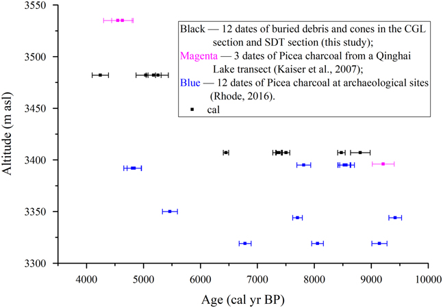
The ages of 27 samples of Holocene spruce charcoal fragments, buried wood, and cones from strata and archaeological sites in the Qinghai Lake basin are shown in Table 3 and Figure 6, including 15 ages from strata and 12 ages from archaeological sites. Spruce expanded during the early to middle Holocene in response to higher growing-season precipitation and warmer temperatures when the Asian monsoons reached maximum strength and the lake level rose to its Holocene high (Colman et al., Reference Colman, Yu and An2007; An et al., Reference An, Colman and Zhou2012; Liu et al., Reference Liu, Lai and Madsen2015). Pollen records from the northeastern Tibet-Qinghai Plateau reveal a dramatic and extensive forest decline beginning at about 6 ka, and changes in the intensity of the East Asian summer monsoon are the most likely explanation for the widespread decline of the forest (Herzschuh et al., Reference Herzschuh, Birks and Liu2010).

Figure 6 Calibrated AMS radiocarbon dates of spruce charcoal, debris, or cones from archaeological sites and sedimentary strata in Qinghai Lake basin (solid symbols with 2σ error bar). (For interpretation of the references to color in this figure, the reader is referred to the web version of this article.)
Table 3 Radiocarbon dates of spruce charcoal, debris, and cones from Qinghai Lake basin, organized by age.

The buried Picea crassifolia Kom. in the CGL section (altitude 3407 m.asl) is mainly concentrated within the age range of 9.6–6.5 ka, and 6.3–4 ka in the SDT section (altitude 3482 m.asl). In addition, the buried debris and cones found in strata older than 6 ka were noticeably more abundant than those after 6 ka. We can deduce that the spruce retreated to a high altitude at ~6 ka, which is consistent with a decrease in tree pollen percentage of the Qinghai Lake sediments (Shen et al., Reference Shen, Liu and Wang2005b) and the widespread forest decline in the Tibetan-Qinghai Plateau (Herzschuh et al., Reference Herzschuh, Birks and Liu2010). Because the wood that was the source of the charcoal found at archaeological sites could have been transported from higher-altitude locations by humans, it does not necessarily reflect the true altitude at which the tree grew. If we only analyze the spruce ages from sedimentary strata, we can discern similar trends indicating that the spruce retreated to a higher altitude from ~6 ka and disappeared at ~4 ka (Fig. 6), which is consistent with the aridity trend since the middle Holocene.
There are differing viewpoints regarding the decline and disappearance of forest in the Qinghai-Tibetan Plateau. Charcoal is generally regarded as indicating human-induced fires. Kaiser et al. (Reference Kaiser, Schoch and Miehe2007) believed that humans could have been responsible for erosion in the early Holocene via land-use practices in the Qinghai Lake basin. Based on charcoal records, Miehe et al. (Reference Miehe, Miehe and Kaiser2009, Reference Miehe, Miehe and Böhner2014) considered that early pastoralists continued to burn forests to create pastureland, and that pastoralists in the southeastern Tibetan highlands took advantage of the middle Holocene climatic optimum to convert forests into high-yield pasture with the help of fire. In the Bronze Age, clearance of the natural vegetation was thought have caused disastrous erosion, which led to a decline and colluvial coverage of two geoarchaeological sites (Lajia site and Fengtai site) near Xining (Kaiser et al., Reference Kaiser, Schoch and Miehe2007). The establishment of pastoralism as the dominant economic system in Qinghai Lake basin may have accelerated the decline of spruce, accompanied by intensified late Holocene cooling and drying trends (Rhode, Reference Rhode2016).
Buried spruce wood and cones were only found in the CGL and SDT sections; 15 of the 27 ages of Holocene spruce in Qinghai Lake basin are based on dating of charcoals (Table 3). There is no significant increase in the charcoal quantity from 9.5 to 4 ka (Fig. 6). The first permanent village settlements in the Qinghai Lake basin are dated to ~3380–2830 yr BP (~3605–2957 cal yr BP) (Chen et al., Reference Chen, Dong and Zhang2015; Rhode, Reference Rhode2016), which could be associated with forest disappearance. Overall, more evidence is needed to determine the effects of human activity on the decline or disappearance of forest in Qinghai Lake basin.
CONCLUSIONS
Pollen can be transported long distances, and the wood that was the source of charcoals at archaeological sites could have been transported from elsewhere by humans; in contrast, plant macrofossils in sedimentary strata probably reliably reflect the actual regional paleo-vegetation.
Sedimentary strata containing abundant woody debris and cones were discovered in two sections in the eastern margin of Hudong Sandy Land, to the east of Qinghai Lake basin. Analysis of the anatomical structure of the wood and the cones confirmed that the debris belongs to Picea crassifolia Kom. The woody material is dated to 9.7–4.2 ka, while the large trunks or branches are dated mainly to 7.5–6.5 ka. These findings provide direct evidence at the species level for the presence of Qinghai spruce forest in the early-middle Holocene. In addition, the occurrence of cones within the study sections indicates that the early-middle Holocene environment was suitable for the propagation of Picea crassifolia Kom.
Whether broadleaf trees such as Betula ever grew in the area during the Holocene has not yet been proven by an independent charcoal record or the presence of wood remains from archaeological sites or sedimentary strata. In addition, quantitative climatic reconstructions from pollen records from the Qilian Mountains indicate that temperature during the middle Holocene thermal maximum could not support the growth of broadleaf trees. Therefore, it is probable that only coniferous forest was present in Qinghai Lake basin during the early-middle Holocene.
The variations in the occurrence of Qinghai spruce forest during the Holocene probably reflect changes in humidity/moisture. According to analyses of the ages and altitudes of spruce debris, cones, and Picea charcoals found in the stratum, spruce trees retreated to a higher altitude after ~6 ka. This finding is consistent with a decrease in the tree pollen percentage in the sediments of Qinghai Lake and with the widespread forest decline in the Tibetan-Qinghai Plateau, which indicate a trend of increasing aridity in Qinghai Lake basin since the middle Holocene. The humid early-middle Holocene was suitable for the growth and reproduction of Qinghai spruce forest, while a shift toward an increasingly arid climate during the late Holocene probably resulted in the disappearance of Picea crassifolia Kom. from Qinghai Lake basin, although human activities may also have contributed to the environmental change.
ACKNOWLEDGMENTS
This research was supported by the National Natural Science Foundation of China (grant no. 41571184) and the Ministry of Science and Technology of the People’s Republic of China (grant no. 2013CB956001).