Introduction
Ever since their discovery, the exact age of the abundant rock art of the Gilf Kebir-Jebel Uweinat region in Libya, Sudan and Egypt has been a matter of intense speculation and debate. After the initial discoveries and surveys in the 1930s and 1960s (Winkler Reference Winkler1939; Rhotert Reference Rhotert1952; Van Noten Reference Van Noten1978), the rock art of the region received little attention. A number of chronologies were proposed based on matching the fauna depicted, or archaeozoological remains, with climatic evidence and analogies from the Nile Valley or the Sahara (McHugh Reference McHugh1971, Reference McHugh1974; Muzzolini Reference Muzzolini1980; Le Quellec Reference Le Quellec1998; Le Quellec et al. Reference Le Quellec, De Flers and De Flers2005). At the same time, archaeology and palaeoclimatology provided a chronological framework for the Holocene settlement of the central Libyan Desert (Eastern Sahara) (Linstädter & Tegtmeier Reference Linstädter and Tegtmeier2005; Riemer Reference Riemer2009). Integration of rock art in this framework was not possible, however, due to the inherent limitations of the traditional dating methods (Di Lernia & Gallinaro Reference Di Lernia and Gallinaro2010).
Much of the Gilf Kebir plateau, Jebel Uweinat and the surrounding smaller massifs were surveyed systematically only in the past decade, raising the number of known sites from about 200 to 1200, revealing most superimpositions of chronological relevance (Zboray Reference Riemer and Kuper2013). The first systematic archaeological excavation in a painted rockshelter in the region started at Wadi Sura in 2009 (Kuper Reference Kuper2013). As a result of these efforts, a large corpus of rock art and related data is now available for meaningful analysis.
Using an interdisciplinary approach, this article amalgamates first-hand information in the fields of climate and environmental change, rock art, archaeology and settlement history. Based on our long-term investigations, we combine the primary environmental and climatic evidence, 14C dates, stratigraphy and other chronologically relevant archaeological indicators with a systematic analysis of the relative sequence of local rock art styles derived from superimpositions and weathering. Evidence from each discipline was found to corroborate that from the others, enabling the establishment of an absolute chronological framework for the Holocene rock art in the region with a good level of confidence.
We are aware that understanding the purpose of rock art, and the complex reasons why rock art appears in a particular fashion at a specific place and time, needs a deeper discussion than what is expressed in this brief article. The assessment of the various factors that may influence stylistic variability, such as demography, mobility, subsistence, group identity, ritual behaviour and integration into the landscape is only beginning to appear from the recent, more controlled investigations. A synthesis permitting the formation and dating of stylistic change in line with the archaeological and environmental sequences, as presented here, is a first step towards a deeper understanding of the current rock art.
The evidence from climatology
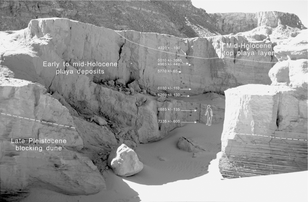
The Gilf Kebir plateau is a huge, flat-topped sandstone plateau in the remote south-western corner of Egypt (Figures 1 & 2), presently at the core of the largest hyper-arid region on earth, receiving less than 2mm of average annual rainfall. A unique geological section in Wadi Bakht, one of its longest eastern canyons (Wadi Bakht 82/13), provides the thickest and most detailed archive of early to mid-Holocene deposits in the central Libyan Desert. The deposits formed due to the previous complete blockage of the valley by a still partly preserved fossil dune, creating a large pluvial playa (temporary water pool fed exclusively by local rainfall and run-off) with a thick valley fill upstream of the blockage. The entire section of playa deposits are exposed in an erosion gap where the blocking dune was breached, forming a step-like gorge that descends 9m from the horizontal playa surface to the original valley floor.

Figure 1. Map of the central Libyan Desert.

Figure 2. The western edge of the Gilf Kebir plateau near Wadi Sura.
The deposits are composed of thin, alternating layers of siliceous mud and partly cemented sands, which imply that the playa was holding water for weeks or months at most. The sedimentary sequence records every major rainfall event in the intake area during the entire early and mid Holocene (Figure 3), with an exposed thickness of 8m. Charcoal samples from the section and surrounding archaeological sites provided a dozen radiocarbon dates, permitting accurate dating of the entire exposed sequence from about 8400–3500 BC (Kröpelin Reference Kröpelin, Linstädter and Tegtmeier2005), corresponding to a near continuous human occupation.

Figure 3. Section Wadi Bakht 82/13 with main stratigraphic units.
The deposits and other palaeoclimatic evidence from the Eastern Sahara suggest that a hyper-arid climate, similar to the present one, must have prevailed until 8500 years BC because of the complete lack of any earlier sedimentological or biological indicators. The thin, discontinuous clay-silt layers in the lower parts of the section, dated between 8400 BC and approximately 4300 BC, indicate an arid climate with rare heavy rainfall (four major events per 100 years on average, although lighter rainfall is not distinguishable in the section).
The AMS date of 4220±100 BC marks the onset of a compact, contiguous 1.2m-thick top layer of sand-free mud deposits, which differ markedly from the much thinner silt and clay layers below, separated by interlayered aeolian sand. This sharp stratigraphic boundary clearly indicates a major change in the precipitation regime. The end of the accumulation phase at approximately 3500 BC is marked by campsite hearths on the playa surface (Kröpelin Reference Kröpelin, Linstädter and Tegtmeier2005).
Palaeometeorological interpretation of the sediment sequence suggests that a regime of monsoonal-convective summer rains with rare heavy downpours prevailed from about 8500 until 4200 BC, enabling incipient soil formation and sparse plant growth around the temporary playa. During the period 4200–3500 BC, this phase was succeeded by a west-wind-induced climate with steadier winter rains supporting slightly more water-demanding plants, especially grass. Best estimates for annual precipitation range between 100–150mm for the earlier monsoonal period, and 50–100mm for the subsequent winter rain regime (Kröpelin Reference Kröpelin1987).
The two precipitation regimes—the short but more violent downpours of monsoon-driven summer rains, and the more continuous winter rains—obviously had a different effect upon surface run-off, evaporation and soil infiltration of the water. In the monsoonal regime, the bulk of annual precipitation is delivered in a few heavy downpours, typically induced by higher elevation mountains and plateaus. Water rapidly collects in water channels as high-energy torrents, travelling for a considerable distance away from the small catchment area. Subsequently, dense but short-lived vegetation emerges in sandy sections of the water channels, restricted to the narrow bed of the watercourse. The bulk of the run-off reaches the lower, flat sections of the valleys and the large alluvial fans surrounding the highlands. Here, the water may penetrate the sandy soils more deeply, producing more long-lived vegetation such as grass, over a larger area. In the upper bedrock sections of the valleys, in suitably located, shaded basins, standing water may remain for several months after the rain. In areas with suitable geology, some of the run-off may percolate underground and feed year-round springs near the base of the highlands.
The Ennedi plateau in north-east Chad, situated about 700km to the south-west, still receives regular monsoonal summer rains of 50–150mm per year, and morphologically resembles the Gilf Kebir. It may therefore be considered the best modern analogy to the early to mid-Holocene climatic and environmental conditions in the central Libyan Desert. The summer rains fill water holes and produce fresh vegetation along the water channels six to eight weeks after the rain events. This vegetation thrives through the cool winter until the onset of the hot dry season in spring, after which only a few aridity-tolerant plant species (e.g. ‘camel thorn’, Zilla spinosa) remain green until the next summer rains. Even the largest rain-fed pools dry up due to evaporation by spring time, restricting available resources to a few, low-yield, permanent water springs.
The winter precipitation, which typically fell at night because of the nocturnal temperature reduction, was subjected to lower evaporation rates than the monsoonal summer rains, and resulted in better moisture penetration of the thin soil. The steady winter rains also had substantially lower surface run-off rates. The combination of these factors seems to have had a decisive impact on the water availability for plants and especially on grass growth. Accordingly, the total amount of annual precipitation seems to have been less important than its temporal distribution, particularly for the emergence of exploitable grasslands on the high plains of the Gilf Kebir.
The evidence from rock art
Systematic surveys of the Gilf Kebir and Jebel Uweinat region since 2002 resulted in the discovery of nearly a thousand new rock art sites (Zboray Reference Zboray and Kuper2013), increasing the known number by a magnitude of five. A little over half of these sites contain paintings that clearly represent a number of different styles and periods (Zboray Reference Zboray2009). This corpus of new data permits the definition of six distinct cultural entities, as expressed by their different style of paintings: a uniform cattle pastoralist horizon preceded by five other styles that, based on the lack of any domesticates except dogs, are probably the work of hunter-gatherers (Zboray Reference Zboray, Huyge, Noten and Swinne2012).
Wadi Sura style paintings
The Wadi Sura style paintings are found only in a narrow geographic niche along the base of the cliffs of the Western Gilf Kebir, best represented by the well-known sites of the ‘Cave of Swimmers’ and the recently discovered ‘Cave of Beasts’. The paintings show a high degree of abstraction, with their main defining element being the strange ‘headless beasts’ (Figure 4E) and the associated ‘swimming’ figures.

Figure 4. Rock art styles of the central Libyan Desert: A) Uweinat elongated roundheads; B) Uweinat roundheads; C) Miniature style; D) Wadi Wahesh style; E) Wadi Sura style; F) Uweinat cattle pastoralist style.
From the sites currently known, four distinct styles of pre-pastoralist paintings may be recognised at Jebel Uweinat, the highest mountain of the region (Figure 1), and at the surrounding smaller massifs and hills. A number of superimpositions permit the establishment of a regional chronological sequence (Zboray Reference Zboray, Huyge, Noten and Swinne2012).
Uweinat elongated roundheads style
The oldest known paintings are those of the Uweinat elongated roundheads, a peculiar style representing, almost exclusively, elongated human figures with an unnatural body proportion: a small, featureless, round head, long neck and short, stubby arms (Figure 4A). Sometimes the figures are shown with elaborate body decoration. These paintings appear to be concentrated along the southern side of Jebel Uweinat, with a few sporadic finds elsewhere.
Uweinat roundhead style
Over 50 sites have been found with the characteristic Uweinat roundhead paintings in the region surrounding Jebel Uweinat. Three examples of over-painting suggest that they succeed the Uweinat elongated roundhead style, and numerous other examples confirm that they pre-date the other styles of the Uweinat area. The exclusive subject of these paintings is human figures. Sometimes only one is depicted, but they are generally found in groups, often in contorted body postures. The main defining feature is the circular, round head, exaggerated in size compared to normal body proportions, and completely devoid of facial features (Figure 4B).
Miniature style
The subject matter of the Miniature style consists of human figures and wild fauna. The human figures are depicted on a very small scale, with adults at 80–150mm and tiny figures of children as small as 20–30mm, thereby giving rise to the name. Family scenes are common, and mothers holding children in various realistically depicted postures are the signature element of the style (Figure 4C). There are several hunting scenes with very well-drawn and -proportioned giraffes. There is no hint of any domestication. Overall, the style has a very high degree of realism. Over-paintings confirm that it succeeds the Uweinat roundhead style.
Wadi Wahesh style
A handful of large shelters discovered in 2005 reveal a distinct style in the very narrow geographic confines of the upper Wadi Wahesh. This Wadi Wahesh style is not easy to define. Where individual human figures are depicted, they have many features in common with some of the Wadi Sura style paintings, including body decoration, all digits being shown on the hands, and negative handprints underlying some of the paintings (Figure 4D). Dogs are depicted (just as at Wadi Sura), but the differences in dress and the lack of key Wadi Sura elements justify defining them as a distinct style. A single but unambiguous superimposition confirms that they post-date the Uweinat elongated roundhead style.
The above stylistic groups, confirmed by numerous superimpositions, are succeeded across the entire geographic region by a homogeneous, pastoralist artistic tradition with hundreds of sites depicting cattle and associated humans. The cattle pastoralist paintings dominate at Jebel Uweinat, where, of about 500 sites with paintings, over three-quarters contain figures of this style. The principal theme is cattle, with some panels showing hundreds of animals in a great variety of forms and colours (Figure 4F). Sometimes goats and other animals are also present. There are some variations in the style of depicting humans, yet the uniformity of style, body posture and proportions of cattle, as well as the standardised iconography of personal accessories, clearly present a homogeneous artistic tradition. A number of scattered sites attributable to the same tradition may be found throughout the Gilf Kebir, providing conclusive evidence that the cattle pastoralist people roamed across the entire region, encompassing the Jebel Uweinat area and the Gilf Kebir plateau.
Supplementing the information from superimpositions, different degrees of weathering of paintings of distinct styles at the same locality may provide further evidence to confirm their separation in time. The Wadi Sura type paintings are consistently fainter (more weathered) than the overlying cattle paintings and, in general, all of the Wadi Sura paintings in the area show much more intense weathering than the cattle pastoralist paintings, which in some cases appear extremely fresh (Figure 5). A considerable time period apparently elapsed between the Wadi Sura paintings and those made by the cattle pastoralists.

Figure 5. Uweinat cattle pastoralist figure superimposed on weathered Wadi Sura style paintings.
Based on the full corpus of known sites, it may be established that Uweinat roundhead sites are consistently faint and weathered in the Jebel Uweinat area, even in well-protected locations, and the same may be said of the ‘elongated roundhead’ paintings, contrasting with well-preserved cattle pastoralist paintings in some of the same shelters. The Wadi Wahesh and Miniature style paintings show only moderate additional weathering compared to overlapping and adjacent cattle-period paintings, and some well-protected shelters show very good preservation. While such observations by themselves need to be treated with caution, the relative weathering patterns ultimately support the conclusions derived from the superimpositions, and point towards a substantially greater age for the Uweinat roundheads and the Uweinat elongated roundheads than for the cattle pastoralists. The Miniature and Wadi Wahesh styles occupy a period in between, with their positions relative to each other not yet clearly established.
There is no direct evidence linking the relative chronological position of the Wadi Sura paintings with any of the pre-pastoralist styles at Jebel Uweinat, but the circumstantial evidence suggests that the Wadi Sura paintings may temporally overlap or immediately pre-date the Wadi Wahesh style, with the earlier phases of Wadi Sura possibly extending further back in time (Figure 6).

Figure 6. Outline of the Holocene cultural and climatic chronological sequences in the central Libyan Desert.

The evidence from archaeology
In the Gilf Kebir-Jebel Uweinat region, systematic archaeological excavations were conducted during the 1980s and 1990s, focusing on the south-east side of the Gilf Kebir plateau (Schön Reference Schön1996; Lindstädter & Tegtmeier Reference Linstädter and Tegtmeier2005). A short archaeological survey along the foot of the western Jebel Uweinat provided a first insight into the archaeology of one of the rock-art-rich areas of the region (Kuper & Riemer Reference Kuper and Riemer2010). Since 2009, the archaeology of the Wadi Sura area at the south-western Gilf Kebir has been systematically investigated by the Wadi Sura project (Förster et al. Reference Förster, Riemer, Kuper, Huyge, Noten and Swinne2012; Kuper Reference Kuper2013), which provided the key for the dating of the local rock art tradition.
The chronological framework for the Holocene human occupation of much of the Eastern Sahara has been established from more than 400 radiocarbon dates derived from archaeological contexts (Kuper & Kröpelin Reference Kuper and Kröpelin2006). In the desert regions in Egypt and Sudan, an initial occupation phase during the early Holocene featured hunter-gatherers (as indicated by the associated zoological record) with a blade industry and elongated microliths (c. 8500–6500 BC). This was followed by a mid-Holocene phase of ceramic-bearing hunter-gatherers, featuring short microliths and an increase in grinding implements found on large, repeatedly occupied base camps (c. 6500–4400 BC). The pottery used by groups of the second phase is characterised by distinctive decoration patterns of the Khartoum (or wavy line) pottery known from the Nubian Nile and from many regions of the southern Saharan belt (Figure 7). The key archaeological types inherent to both phases are also evident in the sequence of the Gilf Kebir-Jebel Uweinat region, defined as the ‘Gilf A’ and ‘B’ local phases respectively (Linstädter & Tegtmeier Reference Linstädter and Tegtmeier2005).

Figure 7. Relative frequencies of indicative ceramic types at Wadi Sura and Jebel Uweinat (lower right), and examples of ceramic types: Gilf B phase, 1–3) dotted zigzag decoration; 4) dotted wavy line; 5) incised wavy line; 6) rim decoration; Gilf C phase, 7) herring-bone decoration.
Between 5300 and 4400 BC, much of the low-lying landscapes of the northern and central Libyan Desert became abandoned due to progressing desiccation, while a different cultural unit appeared in the remaining highland refuges. In the Gilf Kebir-Jebel Uweinat region, this ‘Gilf C’ phase is represented by a distinctive local ceramic tradition that started at the end of the Gilf B phase at 4400 BC, and lasted until c. 3500 BC when the entire area became abandoned.
At Wadi Sura, about 400 archaeological sites were recorded. One-third yielded pottery; many of the remaining sites provided chronologically distinctive stone tools. According to the analysis of the potsherds and stone artefacts, the Gilf A phase is poorly represented, both in the number of sites and in the number of artefacts at sites with multiple occupation phases.
The Gilf B phase yielded the earliest pottery in this part of the Sahara, featuring Khartoum-style decorations, such as wavy line and dotted zigzag. Although the great majority of potsherds are undecorated, systematic research on the fabrics during recent years has shown that the undecorated pottery can be fully connected to certain fabrics in the decorated wares. The Gilf C phase ceramics are clearly distinguishable from those of the preceding Gilf B phase because they feature smaller and rather thin-walled vessels, as well as different decoration patterns, such as the herring-bone motif.
Of the nearly 2200 potsherds recorded at Wadi Sura, 98 per cent affiliate with the Gilf B phase, while only 2 per cent fit the Gilf C phase (Figure 8). This picture is complemented by the nature of the Gilf C sites, which appear as extremely small and ephemeral, contrasting widely with the often repeatedly occupied, artefact-rich camp sites during the Gilf B phase (Riemer Reference Riemer and Kuper2013).
The Wadi Sura statistics contrast with the results of the 2005 Jebel Uweinat survey. Among the almost 250 sites recorded during this survey, 85 comprise pottery. The statistical analysis of the potsherds revealed that only 53 per cent of these sites affiliate with the Gilf B phase, while 47 per cent yielded pottery of the Gilf C phase. In turn, the number of Gilf A sites is very small and compares well with the results obtained from Wadi Sura (Kuper & Riemer Reference Kuper and Riemer2010).
Synthesis and conclusions
The combined evidence presents three distinct human occupation phases in the Gilf Kebir-Jebel Uweinat region in the early to mid Holocene. There is no evidence for any terminal Pleistocene human occupation or rock art, with extreme desert conditions similar to those of today. Soon afterwards, around 8500 BC, groups of hunter-gatherers moved into the area, with summer monsoonal rains regularly reaching Jebel Uweinat and producing an occasional larger rainfall in the Gilf Kebir. These people, characterised by the Gilf A archaeological assemblage, were present for a 2000-year period, but in very small numbers as attested by the scarcity and small area of their living sites. It cannot entirely be excluded that some rock art dates back to the early Holocene Gilf A phase, but it has been shown that this phase is only marginally represented in archaeological sites. We therefore suggest that the vast majority of the region's rock art was produced after 6500 BC.
At about 6500 BC, there is a marked change in the archaeological record, with the introduction of ceramics and the changed lithic assemblage of the Gilf B period. The climatic conditions were not significantly different from the preceding Gilf A period, yet the revolutionary new technology for food (and water) storage/processing probably permitted semi-permanent settlement of the more favourable areas centred on Jebel Uweinat and the Gilf Kebir, particularly around Wadi Sura. The start of this period coincided with the first major production of rock art, both engravings and paintings.
The Gilf B phase lasted till 4400 BC. At present, it is not possible to directly date the associated rock art styles within the period, but circumstantial evidence permits the establishment of their approximate position. The distribution of ceramics conclusively indicates that Gilf B was the major occupation phase at Wadi Sura. Given the predominance of the Wadi Sura rock art style in the same area (66 per cent of all sites, with a higher proportion of individual figures), we conclude that this rock art tradition was primarily created during the Gilf B phase. Conversely, we deduce that the succeeding cattle pastoralist style, with only a few smaller sites in the area, should equate with the Gilf C phase.
The exact chronological position of the Wadi Sura style is unclear, but further ceramic evidence points towards the second half of the Gilf B period. Mineral-tempered fabrics are dated to the earlier part of the Gilf B phase (Gilf B1), while plant-tempered fabrics, the most abundant pottery type at Wadi Sura, are dated to the latter part (Gilf B2). The numerous examples of overpainting at the principal shelter (‘Cave of Beasts’) suggest a long continuity. Relative weathering indicates a substantial temporal gap between the Wadi Sura people and the later cattle pastoralists. Thus, our best estimate is that the majority of the Wadi Sura paintings were made in the period 5500–5000 BC, with possible remnants surviving into the end of the Gilf B phase.
Aside from the general occupational trends outlined above, there is supporting evidence from Wadi Sura that colour pigments were collected, and paints processed at camp sites and under the rock overhangs during the Gilf B phase. There are nearly 50 pieces of earth pigments found on surveyed camp sites, all in close association with nearby shelters with Wadi Sura style paintings. This evidence further supports the conclusion that the Gilf B phase is to be equated with the Wadi Sura paintings.
At Jebel Uweinat, four distinct styles of paintings fill the 2000-year Gilf B period, with two earlier and two later styles. There is a clearly established succession from the earliest ‘elongated roundhead’ figures through the ‘Uweinat roundhead’ style to the Miniature and Wadi Wahesh styles (the relation of the last two relative to each other has not been established). Both succession and relative weathering suggests that the earlier two styles need to be placed into the first half of the Gilf B phase, while the latter two are closer towards the end of the period. Some similarities between the Wadi Sura and Wadi Wahesh styles suggest contacts or a possible migration of the Wadi Sura people to Jebel Uweinat towards the end of the period.
The association of the Gilf B phase with the pre-pastoralist styles at Jebel Uweinat is supported by surface finds observed at site KTW 11/D, a large site containing exclusively ‘Uweinat roundhead’ style paintings. The area in front of the shelter contains a conspicuous number of Gilf B potsherds, including some with wavy line decoration, but no Gilf C material.
A unique aspect of the Gilf B phase is the sequence of markedly different rock art styles, combined with a practically homogeneous material culture as attested by lithics and ceramics during this period. This illustrates that the styles in question not only represent a chronological change, but also express differing pictorial concepts of neighbouring groups at about the same time. Evidently, although these people were all closely related, some sub-groups chose to express a very distinct identity through their rock art.
During this period, the rock art reveals a strong case for a close link between painting production and repeatedly occupied habitation areas, the latter being characterised by an abundance of seasonal or permanent key resources, such as water and vegetation. Despite the small number of favoured areas at Wadi Sura and in the valleys of Jebel Uweinat, the entire region also provides thin spreads of rock art sites over marginal and largely uninhabited areas where rock faces are present. There are some indications—especially from the more exhaustive survey in the environs of Wadi Sura—that rock art in secluded areas often occurs in conjunction with old trails where the art marks crossroads and passes on long-distance interconnections, or cardinal points along short logistical moves to key resources. But much of this rock art is represented by engravings whose chronological or cultural identity has not yet been sufficiently explored.
At 4400 BC, there is a marked change in both the material culture and the rock art corresponding to the Gilf C phase and the cattle pastoralist paintings. Jebel Uweinat was clearly the centre of the cattle pastoralists as attested by the frequency and size of the sites. Although the early rock art styles are quite well represented in most areas of the massif, depictions of cattle and associated representations of the cattle pastoralists dominate the rock art of the entire Jebel Uweinat. This corresponds to the evidence from ceramics: the 2005 survey yielded close to 50 per cent Gilf C material from western Uweinat, a stark contrast to the 2 per cent from Wadi Sura (Figure 7).
This change in material culture and rock art coincided with a significant shift in the climatic conditions in the Gilf Kebir. The evidence suggests that this was not accidental, but that the change in climatic conditions permitted the introduction of cattle pastoralism in the area. It is probable that the cattle pastoralists moved into this new, exploitable area, possibly displacing or simply absorbing the small number of indigenous population.
The climatic transition at about 4400 BC appears to have induced a fundamental environmental change that resulted in different patterns of human behaviour, economy and land-use in the canyon-like valleys and on the surrounding plains. Despite a marked trend towards increasing aridity in the region, the mid-Holocene winter rainfall pattern apparently produced more favourable conditions than did the monsoonal short summer precipitation during the preceding millennia. We hypothesise that this unique weather pattern made cattle pastoralism possible in this very marginal environment.
Jebel Uweinat received regular summer monsoon rains that provided water and pasturage throughout the autumn and winter, yet conditions would have become very stressful at the onset of the hot spring and summer months before the arrival of the rains. The thin but consistent coverage of cattle pastoralist sites scattered about the valleys of the Gilf Kebir plateau, represented by paintings and Gilf C pottery, suggest that the spring and early summer pasturages produced by the winter rains were exploited by the pastoralists (either regularly or opportunistically) to survive the hot summer months more successfully. It is unlikely to be coincidental that the time frame for the winter rain regime in the Gilf Kebir matches almost exactly the known time frame of the Gilf C culture (Figure 6). Ultimately, the pastoralists had to abandon these last retreat areas with the return of arid conditions around 3500 BC.
Establishing the first robust multi-proxy chronological framework for the rock art of the central Libyan Desert, we conclude that the majority of the abundant rock paintings in the Gilf Kebir-Jebel Uweinat area were produced after 6500 BC, with two succeeding phases of distinctive rock art design. The first phase, comprising the Wadi Sura style in the Gilf Kebir and several local styles at Jebel Uweinat, is associated with early ceramic-bearing groups, probably hunter-gatherers. From 4400 BC onwards, correlated with a new pottery tradition, a homogeneous rock art style of pastoral nomads arises in the entire region, featuring lively scenes of thriving cattle herds. This new mode of subsistence was probably an adaptation to a window of opportunity caused by the changing precipitation pattern before the final desiccation of the Eastern Sahara.