Introduction
Generally considered as territorial markers, clusters of stone structures—in particular cairns and enclosures or aligned stones visible on satellite imagery, such as the so-called desert kites—reveal dense and interrelated occupation across the Levant and the Arabian Peninsula during the Mid-Holocene (c. 6.5k–2.8k BC) (Steimer-Herbet Reference Steimer-Herbet2004). This phenomenon also suggests that a pastoralist way of life spread along the desert margins for a distance of over 2000km during this Mid-Holocene period of transition from the Late Neolithic to the Chalcolithic (Guagnin et al. Reference Guagnin, Shipton, Martin and Petraglia2017). As elsewhere in the world (e.g. Göbekli Tepe and Stonehenge; see Parker Pearson Reference Parker Pearson2013; Schmidt Reference Schmidt2015), the most exceptional of these megaliths can be considered as places for social gatherings and associated ceremonies.
Unlike in the southern Levant, prehistoric stone monuments in northern Saudi Arabia remain largely unexplored (Nayeem Reference Nayeem1990; Fujii Reference Fujii2013; Crassard et al. Reference Crassard2015; Kennedy Reference Kennedy2017). Although the mid-Holocene in northern Arabia has been much discussed (e.g. Groucutt & Petraglia Reference Groucutt and Petraglia2012; Crassard & Drechsler Reference Crassard and Drechsler2013; Magee Reference Magee2014), research has focused predominantly on lithic technology, rock art, palaeoclimatic and palaeoenvironmental conditions and infrequently encountered stratified seasonal campsites (e.g. Crassard et al. Reference Crassard, Petraglia, Parker, Parton and Roberts2013; Gebel Reference Gebel2013, Reference Gebel and Luciani2016; Jennings et al. Reference Jennings, Shipton, al-Omari, Alsharekh, Crassard, Groucutt and Petraglia2013; Guagnin et al. Reference Guagnin, Shipton, Martin and Petraglia2017, Reference Guagnin, Shipton, el-Dossary, Moussa, al-Rashid, Stewart, Ott, Alsharekh and Petraglia2018, Reference Guagnin2020; Scerri et al. Reference Scerri2018; Zielhofer et al. Reference Zielhofer2018). The lack of focus on stone monuments is due mostly to the relatively late exploration of the region, the first surveys dating to the 1970s (Adams et al. Reference Adams, Parr, Ibrahim and Mughannum1977; Parr et al. Reference Parr, Zarins, Ibrahim, Waechter, Garrard, Clarke, Bidmeade and Badr1978; Zarins et al. Reference Zarins, Ibrahim, Potts and Edens1979). Furthermore, it is still difficult to date these structures since so few have been excavated.
To gain an overview of such a large-scale phenomenon across the Near East, we must understand how these stone structures, particularly the largest examples, developed in the arid margins. In this regard, the recent excavation of a late Mid-Holocene stone platform in the oasis of Dûmat al-Jandal in Jawf Province, Saudi Arabia, constitutes a major contribution to our understanding of the origin, nature and evolution of human occupation in the region. Detailed analysis of the site, combined with dating of nearby tombs, confirms that ceremonial activity took place at this northern Arabian oasis from the second half of the sixth millennium BC onwards.
Architectural and stratigraphic sequence of the platform
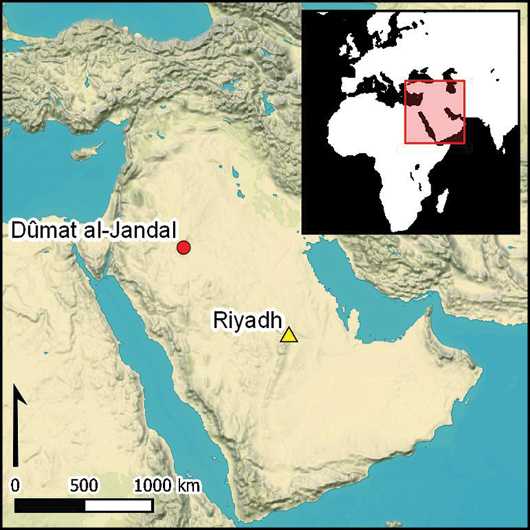
Best known for its role as a crossroads on the caravan routes of antiquity, the oasis of Dûmat al-Jandal, is located in a desert region that today receives no more than 50mm of annual precipitation (Charloux Reference Charloux2018) (Figure 1). The oasis is situated in the lower part of a vast graben (steep-sided valley) at 580–680m asl, supplied with water by several small wadis and, especially, by a now overexploited source of fossil groundwater (Charloux et al. Reference Charloux, Courbon, Thomas and Testa2018).

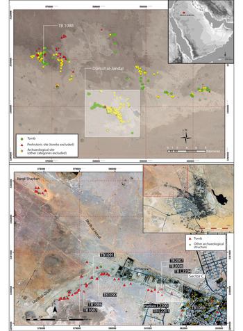
Figure 1. Map of surveys in the Dûmat al-Jandal oasis area in the northern Arabian Peninsula (top), and location of stone tombs around the platform in the western part of the oasis (bottom) (© Archaeological project in Dûmat al-Jandal; figure by G. Charloux).
The study area, in the western part of the oasis, is located on the southern side of the mouth of two small wadis filled with Quaternary alluvial and aeolian deposits. A vast limestone plateau (of the geological formation known as the Qasr Member of the Jauf formation; Wallace et al. Reference Wallace, Dini and Farasani1997), stands some 50m above the valley (average altitude 665m), extending over 2.70km at this location. Most of the archaeological remains are concentrated on a 700m-long natural tongue-shaped promontory on the plateau's northern flank, which belongs to the geological formation known as the Hammamiyat Member of the Jauf formation. Archaeological investigations between 2010 and 2017 have concentrated on a 40ha fortified sector in this area, but also on the systematic recording of archaeological remains within the oasis and in an area approximately 30km around it (Charloux Reference Charloux2018) (Figures 1–2).

Figure 2. Satellite image of the al-Burj promontory showing the locations of archaeological structures (© Archaeological project in Dûmat al-Jandal; figure by G. Charloux).
In 2014–2016, we excavated a monumental stone structure (L2200 on Figures 1–2) on the southern edge of the promontory. It is trapezoidal in shape, taking the form of a platform oriented on an east–west axis (Figures 3–4). The structure survives to a maximum height of 0.70m and is 34.60m long. It is 14.60m wide on its eastern side and 3.40m wide on its western side. The eastern part of the monument has two rectangular niches, each approximately 1m wide and 2m long, symmetrically arranged on either side of the structure's longitudinal axis. The platform is bounded by dry-stone walls and entirely filled with rubble.

Figure 3. A) Aerial view of the platform and niches; B) eastern face of the platform with niches 1 and 2; C) view of the platform from the north (© Archaeological project in Dûmat al-Jandal; photographs by M. Cotty, O. Munoz and R. Schwerdtner).

Figure 4. Digital terrain model and aerial plan view of the platform and its construction phases, showing features mentioned in the text (© Archaeological project in Dûmat al-Jandal; figure by O. Munoz, M. Cotty, G. Charloux, C. Marquaire and R. Schwerdtner).
The platform was built in three phases, followed by an abandonment phase and a later, monumental third- to second-century BC rampart. Four deposits were assigned to the Late Neolithic architectural sequence.
The initial platform (phase I) was built on a west/north-west to east/south-east axis, corresponding to the winter sunrise and sunset. It is trapezoidal in shape, and measures 20.60m in length; its width is 2.70m at its western end and 8.80m at its eastern end. All the phase 1 walls are connected, indicating a single phase of construction. Built either directly on the bedrock or on an indurated marl-limestone layer, the walls comprise rough dry-stone courses of irregular flat stones, on average about 0.20 × 0.30m, and 50–100mm thick. The pressure exerted by the stone infilling created an overhang on the south-eastern side of the platform; to prevent the wall from collapsing outwards, large irregular blocks were added to support it. The eastern facade of the platform has a central niche (niche 1) measuring 1 × 2.15m (Figures 4–5). On the base of this niche, four stones were set vertically in the white substrate, suggesting the presence of a wooden post.
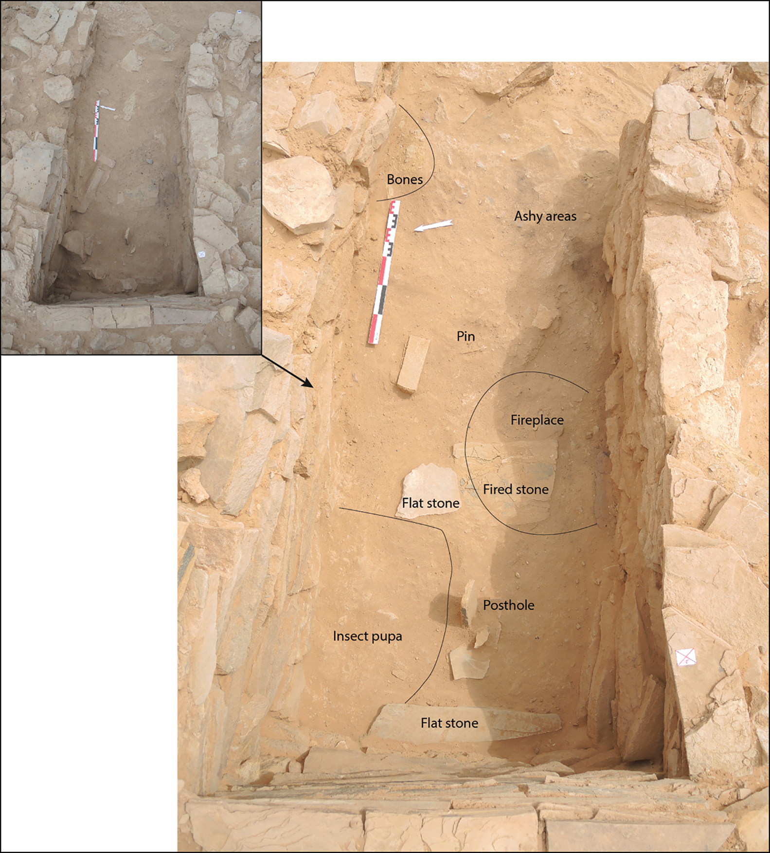
Figure 5. Views of deposit 2 (niche 1) during excavation (© Archaeological Project in Dûmat al-Jandal; photographs by M. Cotty, O. Munoz and G. Charloux).
In phase II, the structure was extended 8.4m towards the north-west, and a second niche installed (niche 2) abutting the northern wall of phase I (Figures 3–4). Niche 2, measuring 2.30 × 1.10m, resembles niche 1 in size, and its layout suggests an attempt at symmetry on either side of the longitudinal axis of the platform. Phase III is an additional extension of 5.30m to the west. The same building techniques were used in this phase, including a coarsely faced wall with rubble infill.
Phase IV corresponds to the abandonment of the structure, attested by the collapse of several walls, such as the western wall and the north-eastern corner of the platform. Phase Va represents the construction of the Hellenistic period (third to second centuries BC) rampart. Surviving to a height of up to 2.65m, this rampart rests partly on the collapsed north-eastern corner of the platform. A layer of green marl between the platform's demolition layer and the first foundation of the rampart indicates that the ground was levelled before its construction. Phase Vb is characterised by the installation of two first-millennium BC hearths on the abandoned platform (see Figure 6 and the online supplementary material (OSM) 1).

Figure 6. Radiocarbon dates and summary of the chronological sequence (Bronk Ramsey Reference Bronk Ramsey2009; Reimer et al. Reference Reimer2013); © Archaeological project in Dûmat al-Jandal; figure by O. Munoz).
Archaeological deposits on the platform
Deposit 1 was discovered within the stone infill of the phase 1 platform. It is characterised by two concentrations of human bones in a secondary position, representing at least one individual aged over 15 years (see OSM 2). Radiocarbon dating of bioapatite indicates that this individual, and probably the associated deposit, dates to the end of the sixth millennium BC (Figure 6 & OSM 1). Two artefacts were associated with this deposit: a white limestone bead and a perforated marine gastropod (Pterygia crenulata) shell (Figure 7A–B).

Figure 7. Artefacts from deposits 1–2 and 4: limestone bead (A) and perforated gastropod (Pterygia crenulata) (B) from deposit 1; stone and shell beads from deposit 4 (C); bone tools (D–E), truncated conical stone (F), lithics (G), terrestrial gastropods of the Melanopsidae family (H) and gravel (I) from deposit 2 (© Archaeological project in Dûmat al-Jandal; photographs by G. Charloux, M. Cotty and A. Chevalier).
Sealed beneath aeolian sandy layers in niche 1, deposit 2 (phases I–IV) contains evidence of human occupation. An ashy layer located at the base of niche 1 was sampled (50 litres) for archaeobotanical analysis. It yielded a moderate quantity of small charcoal fragments, 56 of which have been analysed. Three taxa have been identified (Figure 8A–C & OSM 3): white acacia (Fadherbia albida, 32 fragments), tamarisk (Tamarix sp., 17 fragments) and the Amaranthaceae family (three fragments). Growing to 30m in height, white acacia (Figure 8A–B) is native to the Sudano-Zambezian floristic region (Neumann et al. Reference Neumann, Schoch, Détienne and Schweingruber2001: 318) and is rarely recorded in Arabia today in its wild form (Jagiella & Kürschner Reference Jagiella and Kürschner1987: 20–34). The Amaranthaceae family includes several shrub species with similar anatomical traits. Haloxylon salicornicum is the most widespread, found today in the sandy and rocky plains of north-western Arabia (Kürschner & Neef Reference Kürschner and Neef2011). Tamarix sp. typically grows along watercourses in desert areas (Figure 8A3), Tamarix aphylla being the most common species in north-western Arabia (Miller & Cope Reference Miller and Cope1996). A fragment of tamarisk (Tamarix sp.) from this charcoal layer was radiocarbon-dated to the middle of the sixth millennium BC (Figure 6 & OSM 1).
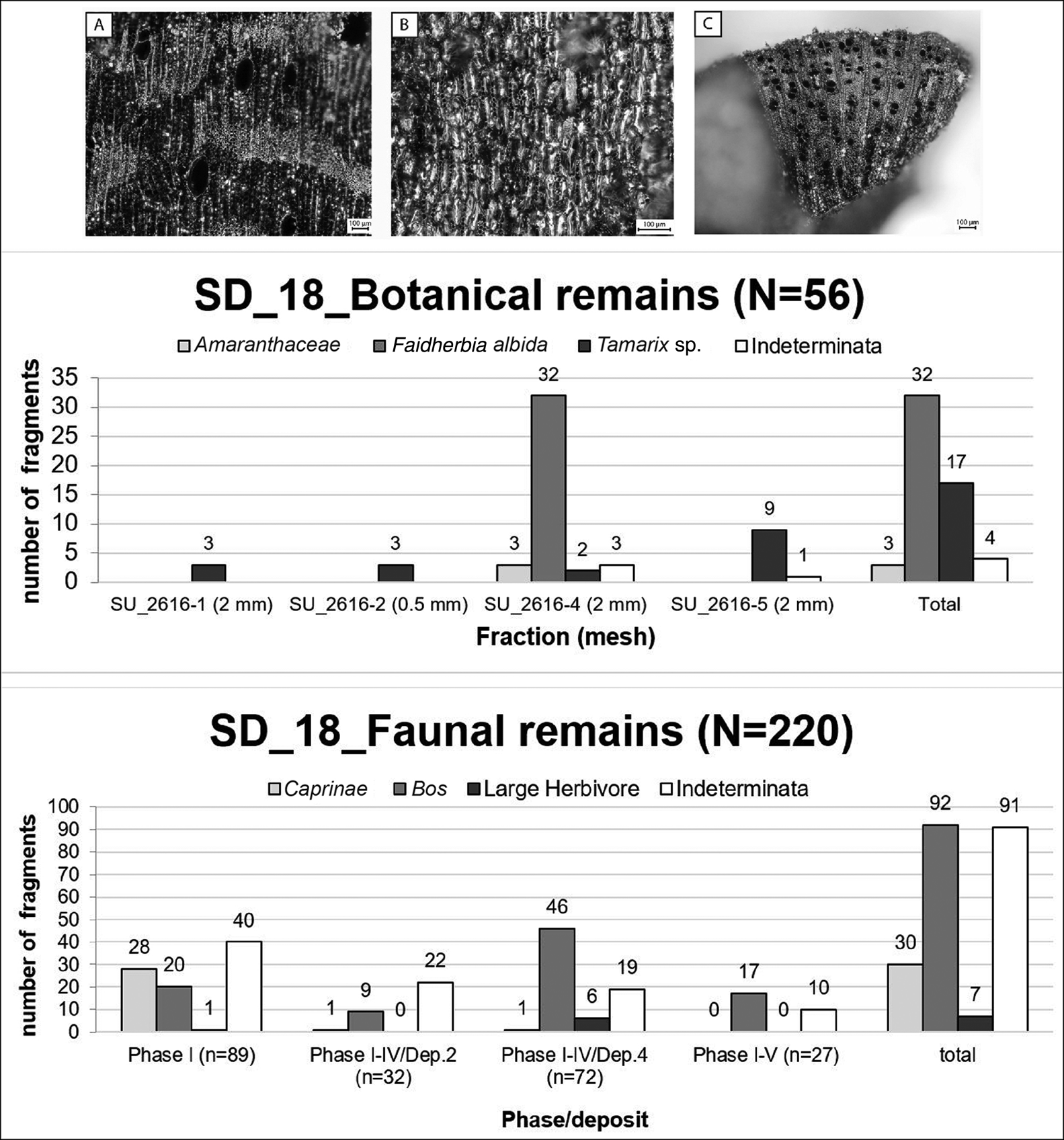
Figure 8. Top) charcoal from deposit 2, microscopic photographs A. Faidherbia albida, transversal section; B. Faidherbia albida, tangential section; C. Tamarix sp., transverse section (© MADAJ; photograph by C. Bouchaud). Middle) results of the charcoal study of deposit 2. Bottom) faunal remains from sounding 18 (© Archaeological project in Dûmat al-Jandal; photograph by H. Monchot).
Deposit 2 in niche 1 also yielded a faunal assemblage (n = 68), comprising 45 fragments of bovid (Bos sp.) maxillary teeth (probably the teeth of a single adult individual), the burnt distal extremity of an ovicaprine metapodial, and 22 unidentified fragments (Figure 8C & OSM 3). Probable exposure to water and sand has resulted in heavy weathering and abrasion of all tooth fragments—as also observed in faunal assemblages from Jabal Oraf 2 and Alshabah in northern Saudi Arabia (Guagnin et al. Reference Guagnin, Shipton, Martin and Petraglia2017; Scerri et al. Reference Scerri2018).
The lithics (Figure 7G) found in deposit 2 mostly consist of small unretouched flakes from two or three different cores. Dating broadly to the Neolithic, these lithics are made of carefully selected raw material, mainly coloured flints and jaspoid cherts, as attested on numerous Mid-Holocene sites across the Arabian Peninsula (e.g. Crassard et al. Reference Crassard, Petraglia, Parker, Parton and Roberts2013).
Deposit 2 in niche 1 also yielded two bone artefacts: a 110mm-long pin and a 55mm-long naviform object of unknown function (Figure 7D–E). Finally, a small cut and polished conical stone mearing approximately 200 × 200mm (Figure 7F) was found in deposit 2. Possibly a small grinding pestle, it resembles an artefact recently discovered in Rajajil in north-western Arabia (Gebel Reference Gebel and Luciani2016: 91, fig. 8).
Evidence of human activity in deposit 3 (phases II–IV) in niche 2 is limited to a few flint flakes and cores, along with a fragment of good-quality chalcedony unknown from the vicinity.
Deposit 4 (phases II–IV) consists of artefacts found disturbed in a recent looting pit dug against the eastern wall of the platform (D4 on Figure 4). Excavation of the pit yielded fragmented and disarticulated human bones (n = 2647) representing at least five individuals (OSM 2), as well as 13 stone and shell beads (Figure 7C & OSM 4). These comprise two cylindrical shell beads, three cylindrical stone beads, three flat beads of whitish stone, and five carnelian beads of either local or Egyptian origin (OSM 4–5). This material was mixed with a loose, orange-brown sand, including many large, irregular stones similar to those of the platform. A radiocarbon assay of a human bone fragment (bioapatite) indicates that the deposit from which the artefacts derive dates to the second half of the fourth millennium BC (Figure 6 & OSM 1). Deposit 4 also yielded a faunal assemblage (n = 75) comprising 48 bovid (Bos sp.) tooth fragments, one burnt distal epiphysis of a caprine metapodial, seven fragments from a large herbivore and 19 unidentified bones (Figure 8).
Discussion
Structurally, the original platform (phase I) appears to have been modified in two successive phases (phases II and III) before it was abandoned, although it is not possible to determine how long the platform was in use. The date obtained on the tamarisk charcoal sample at the base of niche 1 indicates activity as early as the mid sixth millennium BC, followed by a late sixth-millennium BC date for human bone in deposit 1 (Figure 6 & Table S1 in OSM 1). Deposit 4 dates to the second half of the fourth millennium BC, but, as it is disturbed, it cannot be attributed more precisely than to a period between phases II and IV. The monument was certainly in use during the second half of the sixth millennium BC, but a longer period, until the fourth millennium BC, cannot be discounted. The date of the platform's abandonment remains uncertain, with only a terminus ante quem provided by the first-millennium BC construction of the rampart and installation of surface hearths of phase V.
Two categories of archaeological deposit illuminate the function of this platform:
• Funerary deposits (deposits 1 and 4) attest to the repeated use of the area for mortuary activity over two millennia.
• Primary deposits (deposits 2 and 3) in the niches, including artefacts and bioarchaeological remains, potentially related to the symbolic use of the space or structure.
The platform's dimensions and evidence of longevity and maintenance all indicate that it should be considered as a monument (following Osborne Reference Osborne and Osborne2014). In addition to the disposal and commemoration of the dead, the platform's east–west alignment with the winter solstice reveals a knowledge of astronomical phenomena that is common to other structures in Arabia and elsewhere (Steimer-Herbet Reference Steimer-Herbet2004). The platform constituted a ceremonial space for social and ritual activities, providing a material anchor for social memory and identity construction (Scarre Reference Scarre and Insoll2011, Reference Scarre, Brysbaert, Klinkenberg, Gutierrez Garcia-M and Vikatou2018), as well as a territorial marker, for the mobile pastoralists of the area.
Although the Dûmat platform is unique in its proportions, similar stone structures from the southern Levant and the central and southern Arabian Peninsula connect it to a broader cultural tradition. Probably built during the Mid-Holocene (Neolithic to Early Bronze Age) and spanning an area of over 2000km from north–south, these structures vary in length from 6–30m, and have many different shapes, including circular, rectangular and trapezoidal (Figure 9). Most platforms are interpreted as ceremonial structures, collective spaces linked to pastoralism, or cenotaphs (e.g. Zarins et al. Reference Zarins, Ibrahim, Potts and Edens1979; Haiman Reference Haiman1996; al-Khalifa et al. Reference al-Khalifa, al-Hawaiji, al-Daniawi, al-Eisa, al-Helwa, al-Raiyan and al-Shairi2001; McCorriston et al. Reference McCorriston, Harrower, Martin and Oches2012, Reference McCorriston, Harrower, Steimer-Herbet, Williams, Matthiew, al-Hadhari, al-Kathiri, Saliège and Everheart2014; Abu-Azizeh et al. Reference Abu-Azizeh, Abudanah, Twaissi and al-Salameen2014: 167–68; Gebel Reference Gebel and Luciani2016: 87–91; Schiettecatte et al. Reference Schiettecatte, Chevalier, al-Hammad and Tzortzis2017). In addition, these platforms appear to be systematically linked to a religious or a funerary function.

Figure 9. Schematic comparisons of known prehistoric stone platforms (© Archaeological project in Dûmat al-Jandal; figure by G. Charloux).
The presence of a platform at Dûmat al-Jandal and the high density of burials in its vicinity (comprising 66 structures; Figure 1) are also strongly suggestive of prehistoric occupation in or close to the oasis. Predominantly located at the highest points of the landscape and overlooking the wadis, as is frequent in Arabia (e.g. Steimer-Herbet Reference Steimer-Herbet2004; Steimer-Herbet et al. Reference Steimer-Herbet, Davtian and Braemer2006; Cleuziou & Munoz Reference Cleuziou, Munoz, Baray, Brun and Testart2007; Giraud Reference Giraud and Weeks2010), most of the hundreds of (systematically looted and often reused) funerary structures in the Southern Jawf have similar circular shapes (cairns). The assemblages recovered from these tombs are relatively standard, comprising simple elements of adornment (e.g. limestone and carnelian beads, and pierced shells), and, less frequently, metal artefacts (e.g. weapons and tools) or scarab-shaped seals in the most recent tombs (see OSM 4).
Radiocarbon dating was undertaken on human bone from these cairns, revealing at least four periods of use (Figure 6 & OSM 1):
1) Fifth millennium BC, between 4685 and 4075 BC.
2) Second half of the fourth millennium BC to the second half of the third millennium BC (3485–2345 BC).
3) Mid second millennium BC (between 1610 and 1435 BC).
4) First millennium BC to the beginning of the first millennium AD (between 768 BC and AD 55).
One radiocarbon date obtained on a charcoal sample from a cairn burial excavated on the promontory (Tomb L2204, SD31) suggests that it was used at the very end of the first millennium BC to the beginning of the first millennium AD, although the material found in the tomb could suggest an earlier date from the first half of the first millennium BC (Figure 10; see also OSM 1 & 4–5). Continuity in the use of the local funerary landscape is also noted for later periods, with evidence of a Nabataean–Roman necropolis inside the oasis (Figure 6; OSM 1; also see Charloux et al. Reference Charloux, Cotty and Thomas2014).

Figure 10. Artefacts from tomb L2204, SD31: A) Dentalium sp. beads; B) carnelian beads; C) perforated Pterygia crenulata shells; D) Egyptianising scarab; E) faience bead; F–G) stone beads; H) perforated Engina mendicaria shell (© Archaeological project in Dûmat al-Jandal; photographs by G. Charloux and A. Chevalier).
The sequence recorded at Dûmat al-Jandal provides four major lines of evidence. First, the region was repeatedly occupied, from at least the sixth millennium BC, but with hiatuses during the first half of the fourth millennium BC and in the second millennium BC, represented only by tomb TB1088, 15km north-west of Dûmat al-Jandal (Figure 1). Second, the sequence of stone cairns seems to confirm continuity in funerary customs from the fifth millennium BC onwards, potentially suggesting a continuous nomadic pastoralist way of life. Third, the platform is, in the current state of research, the oldest structure in the oasis. Fourth, several tombs may have been contemporaneous with the use of the platform if we envisage a long-term use, although it is possible that the tombs are more recent and not related to the platform, instead forming part of the landscape of the fifth to fourth millennia BC.
Mid-Holocene occupation in the region
After a relatively humid phase lasting from the Early Holocene (8000–6500 BC) to the Mid-Holocene (c. 5000 BC) (Engel et al. Reference Engel, Matter, Parker, Parton, Petraglia, Preston and Preusser2017; Zielhofer et al. Reference Zielhofer2018), it seems that climatic variations in northern Arabia led to aridity in the lowlands around 3000 BC. Palynological research in Taymā’ in north-western Saudi Arabia, for example, shows a progressive decline from semi-arid steppe to the arid/hyper-arid desert-like landscape that we know today (Dinies et al. Reference Dinies, Neef, Plessen, Kürschner and Luciani2016). Several palaeolakes dried up during this period of aridification, for example in the Southern Jawf and the Nefud Desert (Crassard et al. Reference Crassard, Petraglia, Parker, Parton and Roberts2013; Loreto Reference Loreto2013; Guagnin et al. Reference Guagnin, Shipton, el-Dossary, Moussa, al-Rashid, Stewart, Ott, Alsharekh and Petraglia2018). A perennial lake at Taymā’ contracted gradually from 6000 BC onwards, disappearing by 2000 BC (Wellbrock et al. Reference Wellbrock, Strauss, Külls, Grottker, Purdue, Charbonnier and Khalidi2018). Other sites, such as Rasif (also in north-western Saudi Arabia), however, continued to be fed by aquifers (Gebel & Wellbrock Reference Gebel, Wellbrock and Chistos2019). The transition to more arid conditions during the sixth to fourth millennia BC caused the human population to contract as nomadic pastoralism developed. The lack of reliable data on northern Arabian Early and Mid-Holocene annual precipitation, and the scarcity of stratified archaeological contexts, however, preclude a greater understanding of this long-term process. Following the Late Neolithic settlements known to have existed in north-eastern Jordan and northern Saudi Arabia (e.g. Fujii Reference Fujii2010; Rollefson et al. Reference Rollefson, Rowan and Wasse2014; Gebel Reference Gebel and Luciani2016), traces of permanent occupation disappeared in the late sixth to fifth millennia BC in these regions, possibly to be replaced by seasonal camps (Guagnin et al. Reference Guagnin, Shipton, el-Dossary, Moussa, al-Rashid, Stewart, Ott, Alsharekh and Petraglia2018; Scerri et al. Reference Scerri2018). Thousands of stone cairns found across northern Arabia attest to the presence of post-sixth-millennium BC mobile pastoralist populations, who gathered in collective spaces, shrines or funerary areas. These sites fulfilled important collective functions, for example at Rajajil (Zarins et al. Reference Zarins, Ibrahim, Potts and Edens1979; Gebel Reference Gebel2013, Reference Gebel and Luciani2016) and farther afield, for example, at Rizqeh (e.g. Kirkbride Reference Kirkbride1969).
In this regard, the site of Rasif is of primary importance, as it provides evidence for the evolution of water management and lifeways in a ‘proto-oasis’ during the Late Neolithic–Chalcolithic transition (Gebel Reference Gebel and Luciani2016; Zielhofer et al. Reference Zielhofer2018; Gebel & Wellbrock Reference Gebel, Wellbrock and Chistos2019). At Taymā’, fig (Ficus carica type) pollen and seeds dating to c. 4800–4300 BC suggest a Late Chalcolithic to Early Bronze Age permanent occupation and an oasian way of life, a chronology also supported by the archaeological data (Dinies et al. Reference Dinies, Neef, Plessen, Kürschner and Luciani2016; Hausleiter et al. Reference Hausleiter, Eichmann and al-Najem2018).
Considering this overall sequence, it is necessary to question the role and position of the Dûmat al-Jandal oasis during the Chalcolithic to Early Bronze Age periods, in particular the problematic fifth to third millennia BC. The platform (L2200) was built in the Late Neolithic, possibly by mobile pastoralists, while stone structures, including tombs as well as the platform, attest to a recurrent human presence from the second half of the sixth millennium BC. There is little doubt that Dûmat al-Jandal was a well-watered place, and therefore a refuge for human populations throughout its history; a large 5 × 8km basin ranging in depth from 50–100m, the oasis was naturally supplied with water from small wadis and abundant springs (Charloux et al. Reference Charloux, Courbon, Thomas and Testa2018). Although the prehistoric landscape cannot be reconstructed without detailed hydrological and palaeoclimatic analyses, the Dûmat basin certainly contained a palaeolake during the early Mid-Holocene. It may therefore be that this place was only partly affected by the increasing aridity of the later Mid-Holocene.
The long-term human presence at Dûmat al-Jandal—as highlighted by the monumental platform and surrounding funerary landscape—can be explained by the presence of perennial water resources. By overtly marking the landscape with their tombs, the groups frequenting the area may have materialised their presence and asserted their rights and inheritance over these resources (see Parker Pearson Reference Parker Pearson1999). It remains to be ascertained, however, whether the Chalcolithic–Early Bronze Age pastoral nomadic groups, characterised by their burial cairns, occupied a semi-permanent site in the early oasis, as seen at nearby Rasif, or whether they lived alongside populations already permanently settled in the oasis. The second hypothesis would correspond to the indigenous way of life known from the first millennium BC to the nineteenth century AD in the hyper-arid context at Dûmat al-Jandal (Veccia Vaglieri Reference Veccia Vaglieri, Bearman, Bianquis, Bosworth, van Donzel and Heinrichs2012). Both hypotheses would be compatible with an early oasis in the fifth millennium BC, as at Taymâ’ (Hausleiter et al. Reference Hausleiter, Eichmann and al-Najem2018) or at Rasif (Gebel & Wellbrock Reference Gebel, Wellbrock and Chistos2019). At the latter site, local environmental conditions precluded the development of a full oasis economy, such as at Dûmat al-Jandal. Further research should provide greater insights into the subsistence economy of protohistoric Dûmat al-Jandal. Our results suggest that monumental structures and burials in northern Arabia marked the landscape over millennia, anchoring nomadic pastoralists to a significant place, not only for its environmental advantages but also for its significance to the community, a recurrent theme in much pre- and protohistoric archaeology.
Acknowledgements
This study forms part of a Saudi-Italian-French archaeological project at Dûmat al-Jandal, directed by Guillaume Charloux (CNRS) and Romolo Loreto (University of Naples l'Orientale). It is supported by several French (CNRS, Ministry of Foreign Affairs, French Embassy in Riyadh), Italian (Ministry of Foreign Affairs, l'Orientale) and Saudi (Saudi Commission for Tourism and National Heritage) institutions. This research is also funded by the Labex RESMED (ANR-10-LABX-72), under the investment programme ANR-11-IDEX-0004-02. The authors wish to thank Olivier Trombet (Labex BCDiv, UMR 7209) and Anaïs Marrast (Muséum national d'Histoire naturelle, UMR 7209) for their expertise.
Supplementary material
To view supplementary material for this article, please visit https://doi.org/10.15184/aqy.2020.81