1. Introduction
Knowledge of the spatial and temporal distribution of volcanism worldwide is fundamental as it is usually used as a tracer of the tectonic/geodynamic processes and their evolution.
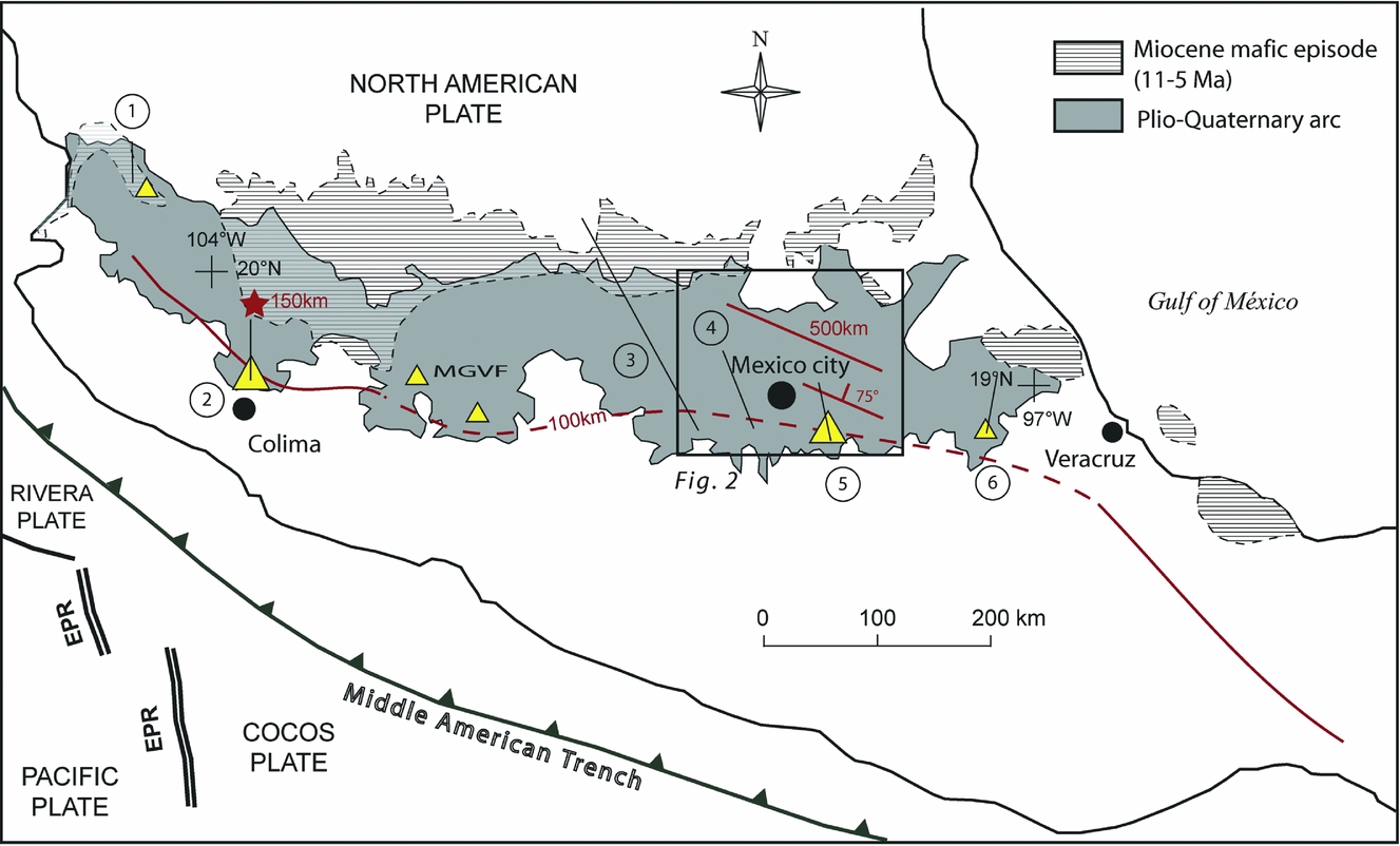
In the so-called Trans-Mexican Volcanic Belt (TMVB), a Mio-Quaternary magmatic arc crossing central Mexico from west to east (Fig. 1), several studies have noted an apparent N–S migration of volcanic activity in the Plio-Quaternary arc (e.g. Luhr & Carmichael, Reference Luhr and Carmichael1980; Nixon et al. Reference Nixon, Demant, Armstrong and Harakal1987; Mora-Alvarez et al. Reference Mora-Alvarez, Caballero-Miranda, Urrutia-Fucogauchi and Uchiumi1991; Delgado-Granados et al. Reference Delgado-Granados, Urrutia-Fucugauchi, Hasenaka and Ban1995; Osete et al. Reference Osete, Ruiz-Martínez, Caballero, Galindo, Urrutia-Fucugauchi and Tarling2000; Márquez et al. Reference Márquez, Oyarzun, De Ignacio and Doblas2001; Fig. 1). The onset of this recent trenchward migration of volcanism is thought to have occurred since the Pliocene (e.g. Gómez-Tuena, Orozco-Esquivel & Ferrari, Reference Gómez-Tuena, Orozco-Esquivel, Ferrari, Alaniz-Álvarez and Nieto-Samaniego2007 and references therein) and is mainly supported by roughly N–S alignments of polygenetic volcanoes along which the volcanic activity migrates southwards with time (e.g. Las Navajas–Cerro Grande, Cantaro–Colima, Palo Huerfano–Nevado de Toluca, Sierra de Las Cruces, Sierra Nevada, Cofre de Perote–Pico de Orizaba; Fig. 1). This idea was first suggested by the morphological evolution observed in most of these ranges, with the lowest and most eroded volcanoes located north of the alignment and the most elevated with high-angle slopes located at the southern tip (e.g. Mooser, Nairn & Negendank, Reference Mooser, Nairn and Negendank1974). If this observation is verified in the ranges of the Sierra Nevada (Fig. 2) and Cantaro–Colima (western TMVB, Fig. 1), it is not the case for other ranges throughout the TMVB (e.g. Sierra de Las Cruces, Fig. 2). In addition, this theory is not yet clearly supported by ages; geochronological data for these volcanic ranges are scattered. Actually, this migration pattern has only been further investigated in the Sierra de Las Cruces (central Mexico; e.g. Mora-Alvarez et al. Reference Mora-Alvarez, Caballero-Miranda, Urrutia-Fucogauchi and Uchiumi1991; Osete et al. Reference Osete, Ruiz-Martínez, Caballero, Galindo, Urrutia-Fucugauchi and Tarling2000; Figs 1, 2) but is still a matter of debate. Indeed, until very recently, on the basis of a few isolated radiometric ages and palaeomagnetic studies, it was claimed that in the Sierra de Las Cruces the volcanism migrated southwards (e.g. Mora-Alvarez et al. Reference Mora-Alvarez, Caballero-Miranda, Urrutia-Fucogauchi and Uchiumi1991; Osete et al. Reference Osete, Ruiz-Martínez, Caballero, Galindo, Urrutia-Fucugauchi and Tarling2000; Márquez et al. Reference Márquez, Oyarzun, De Ignacio and Doblas2001) and a model, extended to the neighbouring ranges, was proposed to explain why and how the volcanism would migrate that way (Márquez et al. Reference Márquez, Oyarzun, De Ignacio and Doblas2001). However, in 2008, on the basis of literature data and additional Ar–Ar ages, Arce et al. brought into question such a migration in the Sierra de Las Cruces.

Figure 1. Map showing the geological setting of the Trans-Mexican Volcanic Belt (TMVB) (modified after Ferrari, Reference Ferrari2004). Rivera and Cocos oceanic plates are subducting beneath the North American plate. The belt forms an angle of about 15° with the Middle American Trench. The 100 km isodepth line of the slabs is indicated after Pardo & Suarez (Reference Pardo and Suarez1995); the line is dashed when the contours were extrapolated because no hypocentral data were available. Star indicates the location where a tearing between Rivera and Cocos plates is detected from 150 km depth (Yang et al. Reference Yang, Grand, Wilson, Guzman-Speziale, Gomez-Gonzalez, Domínguez-Reyes and Ni2009). The straight line north of México city marks the strike of the Cocos plate at the place where it reaches 500 km depth; between Mexico City and this place the slab is sinking with a 75° angle (Husker & Davis, Reference Husker and Davis2009). During Late Miocene time (11–5 Ma), a voluminous mafic episode (horizontal stripes) is recognized across the whole of central Mexico with ages progressively younger from west to east (Gómez-Tuena, Orozco-Esquivel & Ferrari, Reference Gómez-Tuena, Orozco-Esquivel, Ferrari, Alaniz-Álvarez and Nieto-Samaniego2007). The extension of the subsequent Pliocene–Quaternary arc is represented in dark grey. Lines numbered 1 to 6 represent the volcanic alignments on which the volcanic activity is thought to migrate southwards with time. (1) Las Navajas–Cerro Grande; (2) Cantaro–Colima; (3) Palo Huerfano–Nevado de Toluca; (4) Sierra de Las Cruces; (5) Sierra Nevada; (6) Cofre de Perote–Pico de Orizaba (e.g. Alaniz-Alvarez, Nieto-Samaniego & Ferrari, Reference Alaniz-Alvarez, Nieto-Samaniego and Ferrari1998; Márquez et al. Reference Márquez, Oyarzun, De Ignacio and Doblas2001 and references therein). Large triangles are the currently active volcanoes of the TMVB (Colima, Popocatépetl). Smaller triangles are historically active volcanoes from left to right: Ceboruco, Paricutin and Jorullo cinder cones (Michoacan–Guanajuato Volcanic Field, MGVF), Pico de Orizaba. See http://journals.cambridge.org/geo for a colour version of this figure.

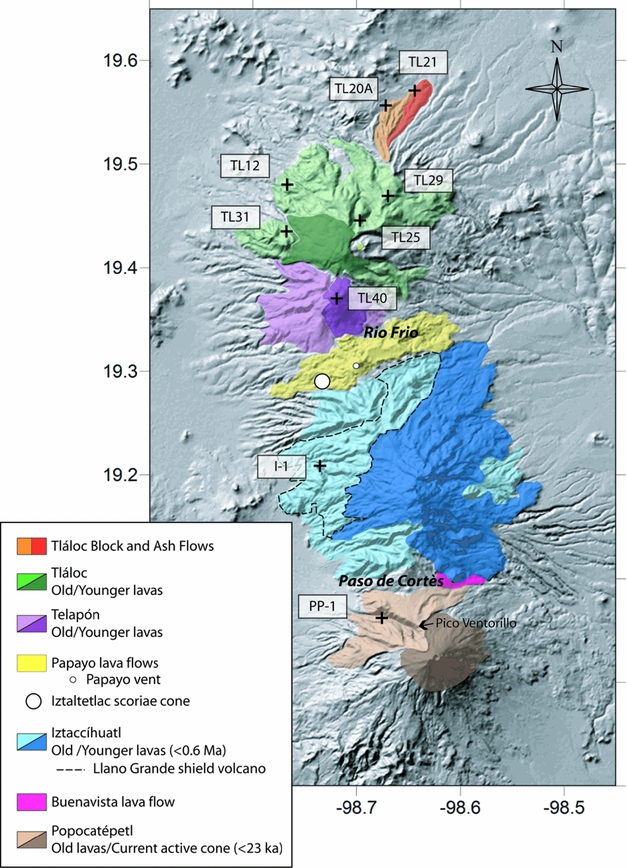
Figure 2. Digital Elevation Model of the Mexico City basin and its surroundings. The Mexico basin, located ~2250 m above sea level, is delimited to the west and to the east by two ranges of polygenetic volcanoes: the Sierra de Las Cruces and the Sierra Nevada, respectively. The Sierra Chichinautzin, composed of monogenetic volcanoes, closes the southern end of the basin. The basin also experienced eruptions from the Nevado de Toluca (polygenetic Quaternary volcano) located around 80 km SW. All these volcanoes emplaced along NE–SW and E–W active normal faults systems (e.g. Mooser, Nairn & Negendank, Reference Mooser, Nairn and Negendank1974; García-Palomo et al. Reference García-Palomo, Macías, Tolson, Valdez and Mora2002, Reference García-Palomo, Zamorano, López-Miguel and Galván-García2008). NE–SW fractures observed at the summit of Tláloc suggest the prolongation of the Tláloc–Apan fault beneath the volcano. Moreover, the NE–SW preferential orientation of Tláloc–Telapón edifices suggests that this fault may have constituted conduits for rising magmas.
The Sierra Nevada (eastern boundary of the Mexico basin; Fig. 2) is one of such ranges of polygenetic volcanoes for which it has been thought for a long time that the volcanism migrates southwards (Mooser, Reference Mooser and Elizondo1975). However, radiometric ages recently obtained on the northernmost Tláloc volcano (C-14 ages on charcoal from tephras; Huddart & Gonzalez, Reference Huddart, Gonzalez, Aguirre-Diaz, Macías and Siebe2004; Rueda et al. Reference Rueda, Arce, Macías and Garcia-Palomo2006; Meier et al. Reference Meier, Grobéty, Arce and Rueda2007) gave ages as young as those of the southern Popocatépetl. This led Rueda et al. (Reference Rueda, Arce, Macías and Garcia-Palomo2006) and Meier et al. (Reference Meier, Grobéty, Arce and Rueda2007) to question the veracity of the long-ingrained southward migration trend in the Sierra Nevada, which was initially mainly inferred from the highly eroded morphology of the northern volcanoes and the unique current activity located at the southernmost Popocatépetl.
In this contribution, we re-examine the temporal distribution of the volcanism along the Sierra Nevada range on the basis of a compilation of ages from the literature and new K–Ar dating. We provide the first K–Ar ages for the northernmost Tláloc and Telapón volcanoes and for the ancestral Popocatépetl (Nexpayantla), as well as a new age for the Palaeo-Iztaccíhuatl.
The aim of this paper is to summarize the current knowledge about the timing of the Sierra Nevada volcanic activity in the light of our new data. The Sierra Nevada volcanism chronology is précised, and a southward migration of the volcanic activity onset is evidenced along this range, though all the stratovolcanoes were active contemporaneously during most of the Pleistocene.
2. Geological setting and historical knowledge of the Sierra Nevada
2.a. Overview of the TMVB general context
The Sierra Nevada is located in the central-eastern part and southern front of the TMVB (Fig. 1). The latter is a magmatic arc crossing Mexico from west to east at latitudes between c. 19 to 21°N (Fig. 1). It was formed through four successive magmatic episodes taking place at different locations across central Mexico since Miocene time (Gómez-Tuena, Orozco-Esquivel & Ferrari, Reference Gómez-Tuena, Orozco-Esquivel, Ferrari, Alaniz-Álvarez and Nieto-Samaniego2007). The first Middle Miocene episode (19 to 11 Ma) formed a broad arc of large polygenetic volcanoes of intermediate composition (partly adakitic) from longitude 102°W to the Gulf of Mexico (see fig. 2 in Gómez-Tuena, Orozco-Esquivel & Ferrari, Reference Gómez-Tuena, Orozco-Esquivel, Ferrari, Alaniz-Álvarez and Nieto-Samaniego2007). During Late Miocene time (11 to 5 Ma), voluminous mafic volcanism took place across the whole of central Mexico to the north of the previous arc, with ages progressively younger from west to east. Then, in the latest Miocene and Early Pliocene (7.5 to 3.5 Ma), large calderas and silicic dome complexes developed southward. Adakitic-like magmatism has been identified during the Miocene and Plio-Quaternary (e.g. Luhr, Reference Luhr2000; Martinez-Serrano et al. Reference Martinez-Serrano, Schaaf, Solis-Pichardo, Hernandez-Bernal, Hernandez-Trevino, Julio Morales-Contreras and Macías2004; Petrone & Ferrari, Reference Petrone and Ferrari2008), while ocean island basalt (OIB)-like lavas have been emplaced since the Early Pliocene (e.g. Gómez-Tuena, Orozco-Esquivel & Ferrari, Reference Gómez-Tuena, Orozco-Esquivel, Ferrari, Alaniz-Álvarez and Nieto-Samaniego2007). Current volcanic activity is located at the southern front of the belt (e.g. Colima, Popocatépetl; Fig. 1).
The origin of the TMVB has been and is still hotly debated (e.g. Moore et al. Reference Moore, Marone, Carmichael and Renne1994, Márquez et al. Reference Márquez, Oyarzun, Doblas and Verma1999, Sheth, Torres-Alvarado & Verma, Reference Sheth, Torres-Alvarado and Verma2000; Verma, Reference Verma, Delgado-Granados, Aguirre-Diaz and Stock2000, Reference Verma2002; Ferrari; Reference Ferrari2004). Its volcanism, dominantly calc-alkaline, is generally related to the subduction of the Rivera and Cocos oceanic plates beneath the North American plate (e.g. Ponce et al. Reference Ponce, Gaulon, Suàrez and Lomas1992; Singh & Pardo, Reference Singh and Pardo1993; Pardo & Suarez, Reference Pardo and Suarez1993, Reference Pardo and Suarez1995; Wallace & Carmichael, Reference Wallace and Carmichael1999; Cervantes & Wallace, Reference Cervantes and Wallace2003; Gómez-Tuena et al. Reference Gómez-Tuena, Lagatta, Langmuir, Goldstein, Ortega-Gutierrez and Carrasco-Nuñez2003; Ferrari, Reference Ferrari2004; Vigouroux, Wallace & Kent, Reference Vigouroux, Wallace and Kent2008; Johnson et al. Reference Johnson, Wallace, Delgado Granados, Manea, Kent, Bindeman and Donegan2009; Fig. 1).
2.b. What is the Sierra Nevada range?
The Sierra Nevada sensu lato is a roughly N–S-directed range of polygenetic volcanoes representing the eastern boundary of the Mexico City basin (2250 m above sea level; Fig. 2). It is mainly composed of four stratovolcanoes, which are from south to north, respectively (Fig. 2): the still active Popocatépetl, the Iztaccíhuatl, the Telapón and the Tláloc (also named Cerro El Mirador). In the topographic depression of Rio Frio between Iztaccíhuatl and El Telapón (Figs 3, 4), lies the Papayo dome with its voluminous dacitic lava flows that travelled about 10 km from the vent (i.e. the dome) both to the WSW and ENE. On the western side, these flows surround the Iztaltetlac scoria cone (Fig. 3).

Figure 3. Shaded relief and simplified geological map of the Sierra Nevada volcanic chain. Here, for sake of clarity, for each volcano we only differentiate the oldest part of the edifice with respect to the most recent one. Outcropping remnants of Palaeo-Popocatépetl (~730–30 ka) and the current cone (<23 ka), according to Espinasa-Pereña & Martin-del Pozzo (Reference Espinasa-Pereña, Martin-Del Pozzo, Siebe, Macias and Aguirre-Diaz2006). The two main series of Iztaccíhuatl and the limit of outcropping remnants of the Llano Grande shield volcano are reported after Nixon (Reference Nixon1989). The four stratovolcanoes of the Sierra Nevada are surrounded by pyroclastic deposits, which are not colour outlined in this figure except for the two block and ash flow deposits of Tláloc in which we sampled TL20A and TL21 dacitic lava blocks. The black crosses indicate the sampling location of the rocks dated in this study (Table 3).

Figure 4. Photographs of the Sierra Nevada volcanoes. Upper picture is taken from Tláloc volcano (northern Sierra Nevada) and shows in the foreground the Telapón volcano separated from the snowy Iztaccíhuatl and Popocatépetl (background) by the Rio Frio pass in which lies the Papayo dome and its lava flows. The bottom picture, taken from Telapón summit, shows the Tláloc volcano with its naked summit capped by a rhyodacitic amphibole-bearing vitrophyric lava flowing towards the northwest. See http://journals.cambridge.org/geo for a colour version of this figure.
Originally, the term ‘Sierra Nevada’ sensu stricto only referred to Popocatépetl and Iztaccíhuatl. Tláloc and Telapón were included in a distinct range named ‘Sierra de Rio Frio’ (see for example in Mooser, Nairn & Negendank, Reference Mooser, Nairn and Negendank1974). In this paper, we use the name ‘Sierra Nevada’ sensu lato for the sake of coherence and comparison with recent studies (e.g. Rueda et al. Reference Rueda, Arce, Macías and Garcia-Palomo2006; Meier et al. Reference Meier, Grobéty, Arce and Rueda2007).
Popocatépetl is the highest volcano of the range (5452 m above sea level; Figs 2, 4) and the second highest in Mexico. It has an almost perfect conical shape with steep slopes, which is disturbed on its NW flank by the sharp Ventorrillo peak. This latter represents the remnants of an older cone named Nexpayantla (Fig. 3). The summit of Popocatépetl is formed by a steep-walled, ~900 m diameter, 150 m deep crater from which water steam, gas and ash frequently escape (Macías & Siebe, Reference Macías and Siebe2005; Centro Nacional de Prevención de Desastres (CENAPRED) website http://www.cenapred.unam.mx). The Popocatépetl cone consists of numerous interlayered lava flows and pyroclastic deposits of andesitic to dacitic composition (Robin, Reference Robin1984; Schaaf et al. Reference Schaaf, Stimac, Siebe and Macías2005) deposited in the current eruptive cycle that began c. 23 ka bp (Siebe & Macías, Reference Siebe, Macías, Siebe, Macias and Aguirre-Diaz2006). The ancestral volcano (Nexpayantla) is formed by a succession of lava flows of basaltic andesite to dacite.
When observed from the Mexico basin, the morphology of Iztaccíhuatl, as its Náhuatl native name meaning ‘the woman in white’ evokes, resembles a woman lying on her back along a NNW–SSE direction (Fig. 2), with her head to the north. This volcano presents four peaks named La Cabeza (the head), El Pecho (the breast), Las Rodillas (the knees) and Los Pies (the feet). The highest peak (El Pecho) culminates at 5286 m above sea level (Fig. 4). This morphology is the result of a complex interlocking and collapse of different volcanoes, lava domes and flows (e.g. Nixon, Reference Nixon1989). Nixon (Reference Nixon1989) divided the products of Iztaccíhuatl into two main series: (1) the oldest (>0.6 Ma), including the remnant of a shield volcano called Llano Grande (Fig. 3), is composed of andesite and dacite (Nixon, Reference Nixon1989), while (2) the youngest, mainly represented by the highest peaks, is composed of basaltic andesite, andesite and dacite (Nixon, Reference Nixon1989).
The Tláloc and El Telapón are the lowest volcanoes of the Sierra Nevada (4120 and 4080 m above sea level, respectively; Fig. 2). They tend to be oriented following the NE–SW trend of the regional Tláloc–Apan fault (Fig. 2). The summit of the Tláloc and the edifice as a whole are rather flat (Fig. 4), while its neighbour presents steeper slopes. Both edifices are mainly composed of dacitic lava flows and domes, and are surrounded by pyroclastic flows, block and ash flows and lahar deposits. Basaltic andesites and andesites are found as magmatic enclaves in the basal lavas of both the Tláloc and El Telapón volcanoes (Cadoux et al. Reference Cadoux, Martínez-Serrano, Guillou, Macías and García-Palomo2008; Valadez-Cabrera et al. Reference Valadez-Cabrera, Juárez-López, Cadoux and Martínez Serrano2008).
2.c. Current knowledge of the timing of the Sierra Nevada volcanic activity
Tláloc and El Telapón are thought to be the oldest of the range. Historically, they were first considered as Tertiary volcanoes (i.e. >1.8 Ma; Mooser, Nairn & Negendank, Reference Mooser, Nairn and Negendank1974). According to stratigraphic and palaeomagnetic relationships, it was finally suggested that the Tláloc volcano is as old as Pliocene and as young as Late Pleistocene (García-Palomo et al. Reference García-Palomo, Macías, Tolson, Valdez and Mora2002). Indeed, Tláloc lies on Middle Miocene (Apan andesites: ~12 Ma; García-Palomo et al. Reference García-Palomo, Macías, Tolson, Valdez and Mora2002) and Early Pliocene volcanic rocks (Vasquez-Sanchez & Jaimes-Palomera, Reference Vasquez-Sanchez and Jaimes-Palomera1989), and lavas show a normal remanent magnetism (Mooser, Nairn & Negendank, Reference Mooser, Nairn and Negendank1974). Recently, several authors (e.g. Huddart & Gonzalez, Reference Huddart, Gonzalez, Aguirre-Diaz, Macías and Siebe2004; Rueda et al. Reference Rueda, Arce, Macías and Garcia-Palomo2006; Meier et al. Reference Meier, Grobéty, Arce and Rueda2007) dated different pyroclastic events ascribed to the Tláloc and they indeed obtained Late Pleistocene ages ranging from 38 to 16 ka (Table 1). It is of note that C-14 dates from pyroclastic flow deposits derived from Telapón (Rio Frio Pass; Fig. 3) were reported by Cornwall (Reference Cornwall1971); he gave ages between 35 and 40 ka, close to those of the Tláloc tephras dated so far (Table 1).
Table 1. Radiometric ages compiled from the literature for the Sierra Nevada volcanoes
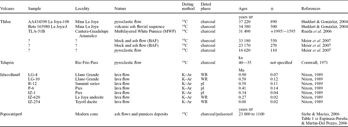
Abbreviations: WR – whole-rock; pl – plagioclase.
Most of the published work concerning the geology of Iztaccíhuatl was done by Graham T. Nixon in the 1980s. According to him, the volcanic activity of the Iztaccíhuatl began with a shield volcano (Llano Grande) ~1.7 Ma ago until 0.6 Ma and then developed lava domes and flows between 0.6 and 0.08 Ma (Fig. 3; Nixon et al. Reference Nixon, Demant, Armstrong and Harakal1987; Nixon, Reference Nixon1989). His K–Ar dates are reported in Table 1. Moreover, Nixon (Reference Nixon1989) first identified a small postglacial dacitic lava flow (~20 m thick, 50–100 m wide and ~4 km long) southeast of Iztaccíhuatl, in the Paso de Cortès pass (Fig. 3); he considered this flow unrelated to Iztaccíhuatl and attributed it to a concealed vent. Subsequent works determined its stratigraphic location between two pre-Ceramic tephra units of the Popocatépetl (Pumice P-4 and Pumice P-3) dated at ~4965 and 9640 years bp respectively (e.g. Espinasa-Pereña & Martin-del Pozzo, 2006 and references therein). The two other volcanic ‘vents’ of the Sierra Nevada, unrelated to the stratovolcanoes’ development, Papayo and Iztaltetlac (Fig. 3), were not dated. The latter is considered a Late Pleistocene cone, while the age of Papayo volcanism was inferred from the glacial tills it covers as younger than 12 ka (Nixon, Reference Nixon1989).
On the basis of stratigraphical and palaeomagnetic constraints, the southernmost activity of the Sierra Nevada started 730 ka ago with the construction of the Nexpayantla volcano (Palaeo-Popocatépetl) until its collapse 50–30 ka ago (Robin, Reference Robin1984; Robin & Boudal, Reference Robin and Boudal1984, Reference Robin and Boudal1987; Conte et al. Reference Conte, Urrutia-Fucugauchi, Goguitchaichvili, Soler-Arechalde and Morton-Bermea2004; Siebe & Macías, Reference Siebe, Macías, Siebe, Macias and Aguirre-Diaz2006); the sharp-peaked Ventorrillo on the NW flank of Popocatépetl (Fig. 3) is considered a remnant of Nexpayantla volcano. So far, no radiometric age has been published on this old volcano. Popocatépetl volcano was constructed to the south of a second Late Pleistocene to Holocene El Fraile cone, between 23 ka and 1.1 ka (Siebe & Macías, Reference Siebe, Macías, Siebe, Macias and Aguirre-Diaz2006 and references therein) and is still active.
From this literature review, it is noteworthy that the eruptive history of the Sierra Nevada, and particularly the initiation of the volcanic activity for each of its stratovolcanoes, is very poorly constrained: (1) For Tláloc and Telapón, the only radiometric ages available are C-14 ages on presumably the youngest activity of the volcanoes. There is no absolute age on solid rocks forming the edifices. (2) Concerning Iztaccíhuatl, as far as we know there are in total only seven K–Ar ages (those of Nixon, Reference Nixon1989; Table 1) comprising two ages on the first event (Llano Grande shield volcano). (3) At Popocatépetl, most of the radiometric ages concern the modern cone (<23 ka; Table 1), which was the object of a detailed tephrochronology since its reactivation in December 1994 (Siebe, Abrams & Macías, Reference Siebe, Abrams and Macías1995; De la Cruz-Reyna et al. Reference De La Cruz-Reyna, Quezada, Peña, Zepeda and Sanchez1995; Delgado-Granados, De la Cruz Reyna & Tilling, Reference Delgado-Granados, De La Cruz Reyna and Tilling2008). Less attention was allocated to the former cones, and there is no absolute dating of the first Nexpayantla cone.
In conclusion, the current geochronological dataset does not allow evidencing a southward migration of volcanism in the Sierra Nevada.
3. Samples and K–Ar dating procedure
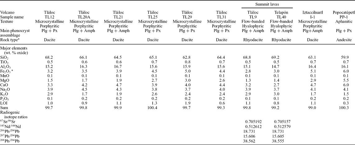
The main petrological features and major element compositions of the samples we dated are given in Table 2.
Table 2. Main petrographical characteristics and major element compositions of dated samples from this study

*Rock type according to Total Alkali versus Silica classification diagram (Le Bas et al. Reference Le Bas, Le Maitre, Streckeisen and Zanettin1986) after recalculation of analyses to 100% on a volatile-free basis.
Major element analyses were performed at the CRPG-SARM (Nancy, France) by ICP-OES except for sample PP-1 which was analysed by XRF at the Instituto de Geologia, UNAM (México D.F.). Sr, Nd and Pb isotopic ratios (authors’ unpub. database) are added for summit lavas of Tláloc (TL9, undated) and Telapón (TL40, 274 ka) in order to outline their strong resemblance and to support the hypothesis of a similar eruption age mentioned in the text (see Section 4.b.). Isotopic analyses were performed with a MS Finnigan MAT 262 at the Laboratorio Universitario de Geoquimica Isotopica (UNAM, México D.F.).
Plg – plagioclase; Px – pyroxene; Amph – amphibole; Fe2O3 * – Total Fe; LOI – loss on ignition.
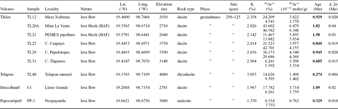
In this work, four dacitic lava samples coming from the basal (presumably stratigraphically oldest) part of the Tláloc edifice and one from Telapón summit were dated by the K–Ar method (Fig. 3; Table 2). Two dacitic lava blocks collected within two discrete block and ash deposits NNE of Tláloc (samples TL20A and TL21; Fig. 3; Table 2) were also dated. These are the first absolute ages on the lavas of these volcanoes. Dating was also performed on one sample from the Palaeo-Iztaccíhuatl (Llano Grande; Fig. 3; Table 2); this is only the third dating of this unit since Nixon (Reference Nixon1989) (Table 1). We provide the first ever published age for the Nexpayantla ancestral cone of Popocatépetl; the sample PP-1 (Fig. 3; Table 2) is an andesite collected in a lava flow unit at the bottom of the Cañada (or ‘Barranca’) Nexpayantla, a deep valley NW of the Popocatépetl summit (Fig. 3), and the unique place where the old lavas outcrop (Espinasa-Pereña & Martin-del Pozzo, Reference Espinasa-Pereña, Martin-Del Pozzo, Siebe, Macias and Aguirre-Diaz2006).
Dating was performed at the Laboratoire des Sciences du Climat et de l'Environnement (LSCE, Gif-sur-Yvette, France) using an unspiked K–Ar technique.
The samples were crushed and sieved to a size fraction of 250–125 μm and were ultrasonically washed in acetic acid (C2H4O2). Because it is the most likely phase to record the time of lava emplacement, potassium and argon were measured on the groundmass. Phenocrysts and xenoliths (which may carry excess argon) were thus eliminated using magnetic, gravimetric and hand picking separation (Guillou et al. Reference Guillou, Carracedo, Torrado and Badiola1996).
Potassium abundance was determined by atomic spectrophotometry with a relative precision of 1%. The isotopic composition and Ar abundance were determined using an unspiked technique described by Charbit, Guillou & Turpin (Reference Charbit, Guillou and Turpin1998). This technique differs from the conventional isotope dilution method in that the argon extracted from the sample is measured in sequence with purified aliquots of atmospheric argon, at the same working gas pressure in the mass spectrometer. This allows one to suppress mass discrimination effects between the atmospheric reference and the unknown (i.e. sample), and allows quantities of radiogenic 40Ar (40Ar*) as small as 0.14% to be detected on a single-run basis (Scaillet & Guillou, Reference Scaillet and Guillou2004).
Argon was extracted by radio frequency induction heating of 0.2–1.0 g of sample, then transferred to an ultra-high-vacuum glass line and purified with titanium sponge and Zr–Ar getters. Isotopic analysis was performed on total 40Ar contents ranging between 1.0 × 10⁻¹¹ and 5.0 × 10⁻¹¹ moles, using a 180°, 6 cm radius mass spectrometer with an accelerating potential of 620 V. The spectrometer was operated in static mode, but its volume was varied to give equal 40Ar signals for the air aliquots and the samples. Beam sizes were measured simultaneously on a double Faraday collector in sets of 100 online acquisitions with a 1 s integration time. The mass spectrometer sensitivity is about 5.1 × 10⁻¹⁵ moles/mV with amplifier background of 0.075 V for 40Ar (109 ohms resistor) and 5.75 mV for 36Ar (1011 ohms resistor). The atmospheric isotopic composition of the procedural blanks was checked by repeated processing of zero-age samples.
The manometric calibration is based on periodic, replicate determinations of international dating standards of known K–Ar age using the same procedure for the unknowns as described in Charbit, Guillou & Turpin (Reference Charbit, Guillou and Turpin1998). This allows the total 40Ar content of the sample to be determined with a precision of about ± 0.2% (2σ). Standards used include LP-6 (127.8 ± 0.7 Ma; Odin, Reference Odin and Odin1982) and HD-B1 (24.21 ± 0.32 Ma; Fuhrmann, Lippolt & Hess, Reference Fuhrmann, Lippolt and Hess1987; Hess & Lippolt, Reference Hess, Lippolt and Odin1994; Hautmann & Lippolt, Reference Hautmann and Lippolt2000). At the 95% confidence level, the values adopted here are consistent with those obtained for several 40Ar/39Ar standards intercalibrated against biotite GA-1550 (Renne et al. Reference Renne, Swisher, Deino, Karner, Owens and Depaolo1998; Spell & McDougall, Reference Spell and McDougall2003). Uncertainties for the K and Ar data are 1σ analytical only, and consist of propagated and quadratically averaged experimental uncertainties arising from the K, total 40Ar and 40Ar * determinations. Uncertainties on the ages are given at 2σ (Table 3).
Table 3. Results of K–Ar dating of volcanic rocks from Sierra Nevada volcanoes

BAF – block and ash flow.
4. Dating results
Our new unspiked K–Ar ages are presented in Table 3.
4.a. Ages for the ancestral Popocatépetl and Iztaccíhuatl
The andesite sample (PP-1; Table 2) from the primitive cone of the Popocatépetl (Nexpayantla) gives an age of 329 ± 10 ka (Table 3). This first absolute age is consistent with the age range of 730–50 ka inferred on the basis of the stratigraphical relationships and palaeomagnetic measurements (see Section 2.c).
The age of 1.09 ± 0.02 Ma obtained for the old unit dacitic sample I-1 (Tables 2, 3), a remnant of a large shield volcano named Llano Grande at Iztaccíhuatl, predates the oldest age obtained by Nixon (Reference Nixon1989) for this same unit (0.9 ± 0.07 Ma; Table 1) but is in agreement with the ages he proposed for the beginning of the shield construction, between 1.7 and 0.6 Ma (Nixon et al. Reference Nixon, Demant, Armstrong and Harakal1987; Nixon, Reference Nixon1988).
4.b. Tláloc and Telapón
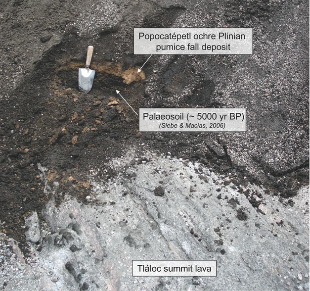
The ages we obtained for the whole Tláloc–Telapón volcanic complex range from 1.82 to 0.274 Ma, and from 1.82 to 0.685 Ma for Tláloc alone (Table 3). The oldest ages of 1.82 ± 0.04 Ma and 1.58 ± 0.03 Ma were both obtained from the lava blocks collected in the block and ash deposits NNE of Tláloc (samples TL20A and TL21; Fig. 3; Table 3). The sample TL21 (1.58 ± 0.03 Ma) is enclosed in a younger block and ash deposit formed c. 33 ka as indicated by the C-14 age obtained on a carbonized wood sample (H. Rueda & J. L. Macías, pers. comm.). We interpret the lava block ages as the ages of solidified lavas, which may have constituted the crater wall of an old cone destroyed by sub-Plinian eruptions acting during the Late Pleistocene (Table 1) and which subsequently became incorporated as blocks in block and ash flows. The Tláloc basal lava flows yield Pleistocene ages from 945 ± 20 ka (TL29) to 685 ± 15 ka (TL31; Table 3). No K–Ar age of the Tláloc summit lava is provided in this paper but it is noted that nearby the summit of Tláloc volcano, a well-identified Popocatépetl pyroclastic deposit lies on its summit lava (Fig. 5). This deposit is characterized by an ochre Plinian pumice-fall deposit overlying a palaeosoil, which was dated at ~5000 years bp (Siebe & Macías, Reference Siebe, Macías, Siebe, Macias and Aguirre-Diaz2006). This gives us at least a relative dating for the summit lava flow of Tláloc as older than ~5000 years bp and younger than 685 ka (TL31; Fig. 3; Table 3). Actually, the texture (flow-banded), the mineralogy and chemistry of this lava (TL9; Table 2) are so similar to the Telapón summit lava (TL40) that we might speculate that they erupted from the same reservoir during the same time period, i.e. 274 ka ago (Table 3).

Figure 5. Photograph showing Popocatépetl ochre pumice fall deposit dated <5000 years bp (Siebe & Macías, Reference Siebe, Macías, Siebe, Macias and Aguirre-Diaz2006) overlying palaeosoil and Tláloc summit lava flow. See http://journals.cambridge.org/geo for a colour version of this figure.
5. Discussion and conclusions
5.a. The Sierra Nevada volcanic history revisited
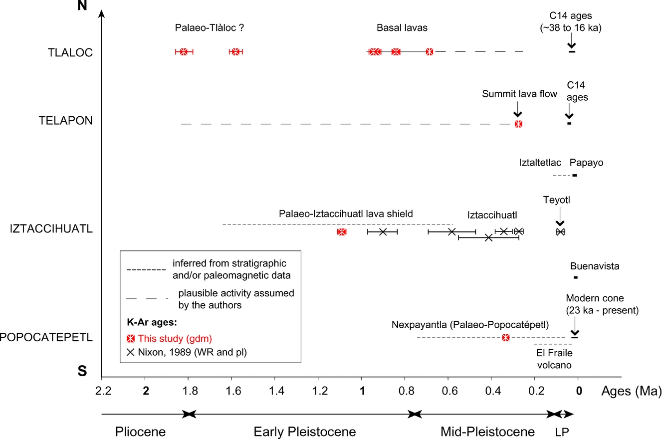
The new K–Ar ages of this study confirm that the volcanic activity of the Sierra Nevada s. l. started at its northern tip at least 1.8 Ma ago (i.e. Late Pliocene; Table 3; Fig. 6). The dated lavas, now enclosed as blocks in block and ash flow deposits from Tláloc volcano, might belong to what we speculate here is possibly a ‘Palaeo-Tláloc’ (Fig. 6) by analogy to the nomenclature used for old edifices at Iztaccíhuatl and Popocatépetl. In addition, this study shows that if Tláloc products record the oldest activity of the Sierra Nevada, its eruptive history widely overlaps those of the southernmost Iztaccíhuatl and Popocatépetl. Indeed, our K–Ar ages indicate that the Iztaccíhuatl lava shield (Llano Grande), which initiated the volcano construction, was forming contemporaneously with the emplacement of basal lava flows of Tláloc (Fig. 6). Moreover, ~38 to 16 ka ago Tláloc was experiencing sub-Plinian eruptions after Iztaccíhuatl ended its eruptive cycle (i.e. 80 ka ago; Nixon, Reference Nixon1989; Fig. 6) and during the construction of the Popocatépetl modern cone (23–1.1 ka; Siebe and Macías, Reference Siebe, Macías, Siebe, Macias and Aguirre-Diaz2006).

Figure 6. Synthesis figure showing the whole geochronological dataset for the Sierra Nevada volcanism (literature data and new data from this study). K–Ar dating by Nixon (Reference Nixon1989) was performed on whole-rock (WR) and plagioclase (pl), while ours were made on the groundmass (gdm). On the bottom axis, LP stands for Late Pleistocene. Age error bars are reported according to Table 1 but are not visible in most of the ages because they are identical or smaller than symbol size. It is of note that if the new data show that Tláloc is effectively the oldest of the Sierra Nevada, it was still active during the construction of the current cone of the Popocatépetl. In fact, the volcanic activity of Tláloc widely overlaps in time the southernmost activities of Iztaccíhuatl and Popocatépetl. See http://journals.cambridge.org/geo for a colour version of this figure.
During Early and Middle Pleistocene time, the Sierra Nevada was the site of intense, mainly effusive volcanic activity, while during Late Pleistocene and Holocene time, the volcanic activity was mainly explosive, with sub-Plinian to Plinian eruptions at Tláloc, Telapón and Popocatépetl (e.g. Rueda et al. Reference Rueda, Arce, Macías and Garcia-Palomo2006; Siebe & Macías, Reference Siebe, Macías, Siebe, Macias and Aguirre-Diaz2006; Table 1). Small effusive events were confined to the passes Rio Frio (Iztaltetlac cone and Papayo dome and lava flows) and Paso de Cortès (Buenavista lava flow; Nixon, Reference Nixon1989; Figs 3, 6).
The first radiometric dates obtained on Tláloc volcano (Huddart & Gonzalez, Reference Huddart, Gonzalez, Aguirre-Diaz, Macías and Siebe2004; Rueda et al. Reference Rueda, Arce, Macías and Garcia-Palomo2006; Meier et al. Reference Meier, Grobéty, Arce and Rueda2007), which gave ages as young as Late Pleistocene to Holocene, surprised most of the researchers involved in the study of the Sierra Nevada volcanoes. It threw up doubts about the long-ingrained pattern of a southward migration of volcanic activity along the Sierra Nevada (e.g. Rueda et al. Reference Rueda, Arce, Macías and Garcia-Palomo2006) and the other N–S volcanic ranges of the TMVB. However, our new data show that, in the case of the Sierra Nevada, if we consider the activity initiation of each stratovolcano along the range, whatever their lifespan, a southward migration is evidenced: the activity began first at Tláloc, then at Iztaccíhuatl and finally at Popocatépetl (Fig. 6). Considering (1) the common location of Tláloc and Telapon along the NE–SW-trending Tláloc–Apan fault and their proximity (less than 5 km between their respective summits), (2) their equally highly eroded morphology (Figs 2, 3) and, (3) their field, petrographical and geochemical similarities (e.g. Cadoux et al. Reference Cadoux, Martínez-Serrano, Guillou, Macías and García-Palomo2008; A. Cadoux & R. G. Martinez-Serrano unpub. data), we believe that these two northernmost edifices share the same feeding system and that their products erupted in the same span of time. As a consequence, we think that the ages lacking for the oldest units of Telapón would not significantly change the general migration pattern.
Recent studies of volcanoes located in other Plio-Quaternary alignments of the TMVB reported a few ages (younger than expected), which have been interpreted as inconsistent with the southward migration (e.g. Sierra de Las Cruces, Arce et al. Reference Arce, Macías, García Palomo, Capra, Macías, Layer and Rueda2008; Cofre de Perote–Pico de Orizaba, Siebert & Carrasco-Nuñez, Reference Siebert and Carrasco-Nuñez2002; Gómez-Tuena et al. Reference Gómez-Tuena, Lagatta, Langmuir, Goldstein, Ortega-Gutierrez and Carrasco-Nuñez2003). However, they have to be taken with caution because these are isolated ages of one or two volcanic edifices and they could just represent the latest products of these volcanoes. Here, the example of the Sierra Nevada demonstrates that the volcano recording the oldest volcanic activity might have been active with the most recent volcanoes. Thus, taking into account only the latest eruptive events or isolated ages on volcanoes could dramatically change the whole scheme. This points out the necessity of detailed chronological investigations of the whole eruptive history of each volcano composing such volcanic chains. However, in order to assess a southward migration of volcanic activity along other alignments of polygenetic volcanoes (Fig. 1), a good strategy for future dating could be to start focusing on the stratigraphically oldest units of each volcano composing the volcanic ranges. The existence (or not) of such a migration is important to unravel as it may have implications regarding the recent evolution of the TMVB.
5.b. Possible explanations for a southward migration of the volcanism
In the literature, two types of explanations have already been invoked that can be summarized as against- and pro-subduction-related processes: (1) Márquez et al. (Reference Márquez, Oyarzun, De Ignacio and Doblas2001) proposed that the southward migration along the volcanic alignments is controlled by the regional extensional tectonics and a simple-shear decoupling at the transition zone between brittle upper-crust and ductile lower-crust (Brittle Ductile Transition Zone, BDTZ) where magmas accumulate (~10 km depth). In this framework, the displacement of extensional stress and subsequent faulting southwards would involve the southward migration of the magma storage locus and thus of the volcanic activity. (2) A significant change of slab dip and/or a slab retreat. Ban et al. (Reference Ban, Hasenaka, Delgado-Granados and Takaoka1992) and Delgado-Granados et al. (Reference Delgado-Granados, Urrutia-Fucugauchi, Hasenaka and Ban1995) suggested that the trenchward migration in the central part of the TMVB could be related to the steepening of the subduction angle of the Cocos plate.
In this study, we show that the northernmost volcano of the Sierra Nevada range (Tláloc) was still active when the southern Iztaccíhuatl became dormant and even during the construction of the Popocatépetl modern cone. This scenario is not consistent with the model of Márquez et al. (Reference Márquez, Oyarzun, De Ignacio and Doblas2001) because this latter implies that magmas rising to be stored at the BDTZ are deviated southwards by the southward displacement of extensional stresses; consequently the former magma storage locus is not fed any more, prohibiting future volcanic activity at this place (see fig. 7 in Márquez et al. Reference Márquez, Oyarzun, De Ignacio and Doblas2001).
We think that the cause of the southward volcanic activity migration is rather related to subduction processes taking into account that: (1) These roughly N–S trends of volcanoes are distributed all along the TMVB (Fig. 1) independently of the laterally varying local tectonic stresses (Suter et al. Reference Suter, López-Martínez, Quintero-Legorreta and Carrillo-Martínez2001); (2) Both the steep dip of the Cocos plate (75° from TMVB southern front) and detachment, recently evidenced by tomography beneath the TMVB (Husker & Davis, Reference Husker and Davis2009; Yang et al. Reference Yang, Grand, Wilson, Guzman-Speziale, Gomez-Gonzalez, Domínguez-Reyes and Ni2009; Fig. 1), strongly suggest the occurrence of a roll-back of the slab. This latter process has already been well documented in other subduction systems (such as the Tyrrhenian–Ionian system, Italy) as a mechanism able to induce a trenchward migration of the volcanism (e.g. Argnani & Savelli, Reference Argnani and Savelli1999; Gvirtzman & Nur, Reference Gvirtzman and Nur1999; Faccenna et al. 2001; Rosenbaum & Lister, Reference Rosenbaum and Lister2004; Schellart et al. Reference Schellart2004).
The regional basement fault systems just favoured the rising of magmas and thus controlled the location and alignment of the edifices but did not control the southward migration of the volcanic activity.
Acknowledgements
The present work was undertaken with the support of a postdoctoral fellowship from the Coordinación de la Investigación Científica (UNAM, México D.F.) assigned to A. Cadoux. T. Hernández-Treviño is thanked for his assistance during fieldwork at Tláloc. This study has been supported by PAPIIT-DGAPA IN113006 and IN118909-3 projects, as well as IGEF internal projects of R. G. Martinez-Serrano and A. Cadoux (POS-2). Anonymous reviewers are thanked for their comments, which helped improve the original manuscript. Finally, AC gratefully acknowledges the editors, Prof. D. Pyle and Dr M. Allen, for paper handling.