


INTRODUCTION
It is estimated that site-based approaches to conservation are appropriate for the long-term maintenance of c. 80% of species of mammals, birds and reptiles (Boyd et al. Reference Boyd, Brooks, Butchart, Edgar, da Fonseca, Hawkins, Hoffmann, Sechrest, Stuart and van Dijk2008). Protected areas, which are areas of land or sea with some degree of legislative protection, are cornerstones of international conservation (Chape et al. Reference Chape, Harrison, Spalding and Lysenko2005), although other approaches, such as community management, also have a role to play in site conservation (Butchart et al. Reference Butchart, Clarke, Smith, Sykes, Scharlemann, Harfoot, Buchanan, Angulo, Balmford, Bertzky, Brooks, Carpenter, Comeros-Raynal, Cornell, Ficetola, Fishpool, Fuller, Geldmann, Harwell, Hilton-Taylor, Hoffmann, Joolia, Joppa, Kingston, May, Milam, Polidoro, Ralph, Richman, Rondinini, Segan, Skolnik, Spalding, Stuart, Symes, Taylor, Visconti, Watson, Wood and Burgess2015). The importance of site-based conservation is acknowledged in Aichi Target 11 of the Convention on Biological Diversity (CBD), which requires world governments to effectively protect at least 17% of terrestrial and inland water and 10% of coastal and marine areas by 2020 (CBD 2011). In addition, and among other things, Target 11 emphasizes the need for this protection to encompass ‘areas of particular importance for biodiversity and ecosystem services’ and to be ‘ecologically representative’ (CBD 2011). Assessments of progress towards this target for terrestrial protected areas (Tittensor et al. Reference Tittensor, Walpole, Hill, Boyce, Britten, Burgess, Butchart, Leadley, Regan, Alkemade and Baumung2014; Butchart et al. Reference Butchart, Clarke, Smith, Sykes, Scharlemann, Harfoot, Buchanan, Angulo, Balmford, Bertzky, Brooks, Carpenter, Comeros-Raynal, Cornell, Ficetola, Fishpool, Fuller, Geldmann, Harwell, Hilton-Taylor, Hoffmann, Joolia, Joppa, Kingston, May, Milam, Polidoro, Ralph, Richman, Rondinini, Segan, Skolnik, Spalding, Stuart, Symes, Taylor, Visconti, Watson, Wood and Burgess2015) suggest that, while many countries have met or are on target to protect over 17% of their land with protected areas, most (62%) would not meet the target of coverage by 2020, and there is a particular need to expand coverage to protect the most valuable sites.
The UK government is a signatory of the CBD, and this extends to the UK's Overseas Territories (UKOTs), for which it is the ‘overarching signatory’. The UKOTs are dispersed islands (except Gibraltar) that support high numbers of globally threatened species (Churchyard et al. Reference Churchyard, Eaton, Havery, Hall, Millet, Farr, Cuthbert, Stringer and Vickery2016) that are particularly at risk because islands are highly vulnerable to invasive species, development and climate change impacts (Dawson et al. Reference Dawson, Oppel, Cuthbert, Holmes, Bird, Butchart, Spatz and Tershy2015). Although the full range of taxa remains unknown, these Territories are estimated to hold over 100,000 native island species and 3300 single-island endemics (Churchyard et al. Reference Churchyard, Eaton, Havery, Hall, Millet, Farr, Cuthbert, Stringer and Vickery2016). Approximately 75% of the species within the UKOTs, for which an International Union for Conservation of Nature (IUCN) Red List of Threatened Species assessment has been carried out, are globally threatened (Churchyard et al. Reference Churchyard, Eaton, Havery, Hall, Millet, Farr, Cuthbert, Stringer and Vickery2016). By comparison, the global figure is c. 30% (IUCN 2016). The protected area coverage of the most important sites for biodiversity in the UKOTs is unknown, but, given the high conservation value of these islands, this is vital information if the UK's contribution to Aichi Target 11 is to be understood and fulfilled.
The CBD has been officially extended to six Overseas Territories (OTs; British Virgin Islands, Cayman Islands, Falkland Islands, Gibraltar, Saint Helena, Ascension and Tristan da Cunha, South Georgia and the South Sandwich Islands). Under the 2001 Environment Charters (agreements between the UK and OT Governments), the UK has a responsibility to ‘help to ensure that the Overseas Territories have the legislation, institutional capacity and mechanisms needed to meet international obligations’ (DEFRA 2009). This UK responsibility is further extended in the UK Government's UK Overseas Territories Biodiversity Strategy (DEFRA 2009), which states that the relevant UK Government departments ‘will provide effective, co-ordinated UK Government support for the conservation and sustainable use of biodiversity in the Territories.’ The extent to which the Aichi Targets apply to individual UKOTs therefore varies, and in some cases is still under discussion, but the 17% terrestrial protection target is still held to be useful as an overall indicator of ambition. The majority of previous studies of progress towards Aichi Target 11 have concentrated upon the global (e.g. Tittensor et al. Reference Tittensor, Walpole, Hill, Boyce, Britten, Burgess, Butchart, Leadley, Regan, Alkemade and Baumung2014) or regional (Beresford et al. Reference Beresford, Buchanan, Sanderson, Jefferson and Donald2016) coverage of the protected area network (but see Mallari et al. Reference Mallari, Collar, McGowan and Marsden2016 on the Philippines). Global or regional assessments might be useful for describing the broad patterns of progress towards CBD targets, but they cannot inform priorities at a smaller geographic scale. It will be at these smaller geographic scales, especially nationally, that information is needed in terms of setting priorities and targeting resources. Such assessments are particularly important on small islands that hold a disproportionately large proportion of the world's threatened species, the distributions of which remain poorly documented (Kingsford et al. Reference Kingsford, Watson, Lundquist, Venter, Hughes, Johnston, Atherton, Gawel, Keith, Mackey, Morley, Possingham, Raynor, Recher and Wilson2009) and where the balancing of conservation priorities, environmental protection and economic development is particularly challenging (Teelucksingh et al. Reference Teelucksingh, Nunes and Perrings2013).
Here, in order to inform on progress towards the CBD and the implementation of UK Government biodiversity conservation support, we examine patterns in the coverage of terrestrial protected areas in the UKOTs. We quantify the current level of protection afforded to the terrestrial areas, the extent to which this captures areas currently identified as being of high biodiversity importance and the extent to which the protected areas contribute to an ecologically representative global network. To assess protected area coverage with respect to sites of high biodiversity importance, we quantify their overlap with Important Bird and Biodiversity Areas (IBAs; e.g. Fishpool & Evans Reference Fishpool and Evans2001). IBAs are a global network of over 10,000 sites of a size amenable to management that are identified based on a semi-objective assessment of their importance for the long-term conservation of birds, but many of which are also important for other taxa (e.g. Pain et al. Reference Pain, Fishpool, Byaruhanga, Arinaitwe and Balmford2005). They have been identified based on capturing populations of globally threatened species, assemblages of range-restricted species, assemblages of biome-restricted species and sites that are important for congregations of populations or species. IBAs are widely used as a measure of biodiversity value elsewhere (e.g. Beresford et al. Reference Beresford, Eshiamwata, Donald, Balmford, Bertzky, Brink, Fishpool, Mayaux, Simonetti and Buchanan2013). IBAs form the only network of sites of conservation importance to have been identified across all UKOTs, in contrast, for example, with Important Plant Areas that exist for UKOTs in the South Atlantic only. To determine whether the protected area coverage is ecologically representative, we quantify their overlap with World Wide Fund for Nature (WWF) ecoregions (Olsen et al. Reference Olson, Dinerstein, Wikramanayake, Burgess, Powell, Underwood, D'Amico, Itoua, Strand, Morrison, Loucks, Allnutt, Ricketts, Kura, Lamoreux, Wettengel, Hedao and Kassem2001), a classification that, like IBAs, has been used in previous studies (e.g. Tear et al. Reference Tear, Stratton, Game, Brown, Apse and Shirer2014). These ecoregions are much more extensive than IBAs and represent areas with geographically distinct assemblages of species, natural communities and environmental conditions (Olsen et al. Reference Olson, Dinerstein, Wikramanayake, Burgess, Powell, Underwood, D'Amico, Itoua, Strand, Morrison, Loucks, Allnutt, Ricketts, Kura, Lamoreux, Wettengel, Hedao and Kassem2001). The results of our analysis will provide a transparent and consistent basis to implementing improvements in biodiversity protection on the UKOTs, particularly as new data become available.
METHODS
We consider 15 UKOT jurisdictions (Fig. 1). Although Ascension Island, Saint Helena and Tristan da Cunha are one administrative unit, we have treated each separately because each island group is biogeographically different. We exclude the British Antarctic Territory, as this Territory falls under the auspices of the Antarctic Treaty system and thereby operates under a different international governance framework. Where available, Territory boundaries of the UKOTs were obtained from UKOT administrations, or National Trusts representing each island (eight Territories). Otherwise, Territory boundaries were obtained from the Global Island Database (six Territories; http://glispa.org/) and the Global Administrative Areas database (one Territory; GADM 2015). Where possible, the accuracy of boundaries was improved through visual inspection of high-resolution satellite images in Google Earth (Dawson et al. Reference Dawson, Oppel, Cuthbert, Holmes, Bird, Butchart, Spatz and Tershy2015). In general, Territory land areas calculated using our digitized boundaries compared favourably with published estimates (mean difference = 1.3%), except for four Territories where this difference exceeded 10% (Anguilla: 13%; British Indian Ocean Territory: 17%; Gibraltar: 12%; Turks and Caicos Islands: 15%).
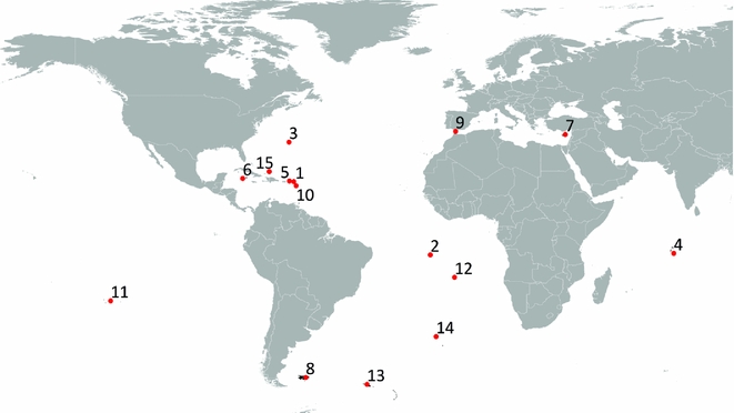
Figure 1 Location of the UK's Overseas Territories where protected area coverage was assessed. 1: Anguilla; 2: Ascension Island; 3: Bermuda; 4: British Indian Ocean Territory; 5: British Virgin Islands; 6: Cayman Islands; 7: Cyprus Sovereign Base Areas; 8: Falkland Islands; 9: Gibraltar; 10: Montserrat; 11: Pitcairn Islands; 12: Saint Helena; 13: South Georgia and the South Sandwich Islands; 14: Tristan da Cunha; 15: Turks and Caicos Islands.
We used the IUCN definition of protected areas (‘A protected area is a clearly defined geographical space, recognized, dedicated and managed, through legal or other effective means, to achieve the long-term conservation of nature with associated ecosystem services and cultural values’; Dudley Reference Dudley2008) to identify terrestrial protected areas for inclusion. We considered all sites that met this designation, but then excluded international designations (e.g. Ramsar sites) in order to assess coverage of locally designated protected areas alone (Table S1) (available online). The latter is the approach that is generally taken by protected area studies (e.g. Jenkins & Joppa Reference Jenkins and Joppa2009, Reference Jenkins and Joppa2010). By preference, we used boundaries supplied by OT administrations. Boundary data for 184 protected areas were obtained this way, while data for a further 48 protected areas (all but five of which were entire islands) were digitized using Territory boundaries and geo-referenced raster images. Boundaries were up to date as of May 2016. Boundaries for nine protected areas were obtained from the Protected Planet database (IUCN & UNEP-WCMC 2015). For 15 protected areas, the boundaries either could not be obtained (two protected areas, 6 ha and 0.8 ha; both in Montserrat) or did not exist (13 protected areas; all in Tristan da Cunha). In these cases, the sites were excluded completely.
We used the total land area of digitized Territory boundaries to calculate the percentage covered by protected areas, having first aggregated boundaries of overlapping protected areas (using the ‘Dissolve’ tool of ArcGIS 10.1). We overlaid protected area boundaries onto IBA boundaries from BirdLife International (Reference International2015) and calculated the percentage of IBAs covered by protected areas. To allow for discrepancies in digitizing between the IBA and protected area layers, we classified the extent of protection of IBAs using three categories, following Beresford et al. (Reference Beresford, Buchanan, Sanderson, Jefferson and Donald2016): >98% of IBA land area under protection, ‘complete’; 2–98% under protection, ‘partial’; and <2% under protection, ‘none’. To quantify whether the level of coverage of protected areas contributed to a globally ecologically representative network, we overlaid protected area boundaries onto WWF ecoregions (Olson et al. Reference Olson, Dinerstein, Wikramanayake, Burgess, Powell, Underwood, D'Amico, Itoua, Strand, Morrison, Loucks, Allnutt, Ricketts, Kura, Lamoreux, Wettengel, Hedao and Kassem2001).
Visual assessment indicated that 8% of IBAs and 64% of ecoregion polygons did not align with the Territory boundaries, such as coastlines. In these cases, the boundaries of the IBAs and ecoregions were aligned manually to coastlines or boundary features. Overlap of IBAs and ecoregions with protected areas was calculated for the portion overlapping Territories by clipping to Territory boundaries. For IBAs comprising both terrestrial and marine habitats, overlap with protected areas was calculated for the terrestrial component only, approximated as the portion overlapping Territory boundaries. The overall area of ecoregions for each Territory was extracted from Olsen et al. (Reference Olson, Dinerstein, Wikramanayake, Burgess, Powell, Underwood, D'Amico, Itoua, Strand, Morrison, Loucks, Allnutt, Ricketts, Kura, Lamoreux, Wettengel, Hedao and Kassem2001). All spatial data were projected using the WGS84 coordinate system, and Mollweide equal area projection and analyses used ArcGIS 10.1 (ESRI 2010).
RESULTS
There were 241 protected areas in the UKOTs. These covered 847 km2 in total, or 4.8% of the land area of the UKOTs. Coverage varied widely across the UKOTs (Table 1), and was highest in the Pitcairn Islands (89%). Eight Territories matched or exceeded the Aichi ambition of protecting 17% of their land. These were Ascension Island, British Indian Ocean Territory, Cyprus Sovereign Base Areas, Gibraltar, Pitcairn, Saint Helena, Turks and Caicos Islands and Tristan da Cunha. The British Virgin Islands fell just short with 16% coverage, while Montserrat had 11% coverage. There were no locally designated protected areas in the Pitcairn Islands, South Georgia and the South Sandwich Islands. The coverage of these locally designated protected areas alone exceeded the 17% Aichi ambition in seven out of 15 UKOTs (Table 1).
Table 1 Terrestrial protected area (PA) coverage in the UK's Overseas Territories. Territories are ranked by descending percentage of total land area designated as protected. Those exceeding Aichi Target 11 (17%) are shown in bold. Land area values were calculated using digitized Territory boundaries.

a Excludes protected areas with no boundary data: two in Montserrat and 13 in Tristan da Cunha.
There were 96 entirely or partly terrestrial IBAs across the 15 UKOTs, covering an estimated 5069 km2 or 29% of the land area of the UKOTs (Table 2). Protected areas overlapped 51% of terrestrial IBAs (49 out of 96 IBAs) completely or partially, but covered only 8% of their area (7% for locally designated protected areas; Table 2). Thirty-three IBAs (34% of all terrestrial IBAs) had more than 50% of their area covered by a protected area, of which the majority (24 IBAs) had more than 98% coverage (Table 2). However, almost half (49%) of all IBA sites and most (92%) of the area of IBAs have no protection. This suggests that the current protected area network does not adequately capture many areas of highest conservation importance for birds (and almost certainly other taxa) within the UKOTs.
Table 2 Number and extent of terrestrial (or partly terrestrial) Important Bird and Biodiversity Areas (IBAs) in the UK's Overseas Territories (OTs) and degree of overlap with protected area coverage. ‘Overall’ includes IBAs with ‘complete’ (>98%) or ‘partial’ (2-98%) coverage; ‘none’ refers to sites with <2% coverage (see text for details). Figures in parentheses in the ‘Overall’ column are the numbers or areas of IBAs under protection when international designations are excluded.

The 15 UKOTs support 16 ecoregions. Most UKOTs fall within a single ecoregion, although four Territories in the Caribbean have two ecoregions (Anguilla, British Virgin Islands, Cayman Islands and Turks and Caicos Islands) and one Territory has three ecoregions (Montserrat). For some ecoregions, the UKOTs are of particular global importance. For example, four ecoregions occur only in the UKOTs (Ascension scrub and grasslands, Bermuda subtropical conifer forests, Saint Helena scrub and woodlands and Tristan Da Cunha–Gough Islands shrub and grasslands), and one (Scotia Sea Islands tundra) has nearly half its global extent within the UKOTs (Table 3).
Table 3 Global extent of ecoregions in UK's Overseas Territories and degree of overlap with protected area (PA) coverage. Territory–ecoregion combinations with ≥17% of their areas protected are shown in bold.

The coverage of ecoregions by protected areas ranged from 0% to 85%. Across all 21 UKOT–ecoregion combinations, nine (43%) had at least 17% of their area covered by protected areas (Table 3). By contrast, Bermuda subtropical conifer forest has less than 1% coverage by protected areas and Scotia Sea Islands tundra has no protected area coverage, despite having 46% of its global extent in the UKOTs. For those UKOTs supporting multiple ecoregions, protected area cover was either dominated by one ecoregion (British Virgin Islands, Montserrat and Turks and Caicos Islands) or very limited for all of the ecoregions (Anguilla and Cayman Islands). The exclusion of internationally designated protected areas affected the coverage of ecoregions in four Territories (British Indian Ocean Territory, British Virgin Islands, Pitcairn Islands and Turks and Caicos Islands), of which that in Pitcairn was the most notable, where Tuamotu tropical moist forests had no locally designated protected areas (Table 3).
DISCUSSION
This analysis provides the first overview and synthesis of the nature and extent of protected area coverage in the UKOTs with respect to both areas of high conservation value and representativeness of ecoregions. It provides an objective and repeatable basis for guiding and informing future terrestrial protected area designation at the UK and individual UKOT level for this geographically disparate but politically linked group of Territories. As more and better data become available, the assessment can be updated.
Overall, the extent of protected area coverage of land was generally low. A total of 4.8% (4.4% with internationally designated sites excluded) of land area was protected across all of the Territories, compared to c. 27% in mainland UK (based on Butchart et al. Reference Butchart, Clarke, Smith, Sykes, Scharlemann, Harfoot, Buchanan, Angulo, Balmford, Bertzky, Brooks, Carpenter, Comeros-Raynal, Cornell, Ficetola, Fishpool, Fuller, Geldmann, Harwell, Hilton-Taylor, Hoffmann, Joolia, Joppa, Kingston, May, Milam, Polidoro, Ralph, Richman, Rondinini, Segan, Skolnik, Spalding, Stuart, Symes, Taylor, Visconti, Watson, Wood and Burgess2015). This low level of protection is a conservation concern because small, isolated islands, such as the UKOTs, often support high levels of endemism (Whittaker Reference Whittaker1998; Heaney Reference Heaney2000). In addition, and partly due to their wide geographic distribution and habitat types, species richness for the island suite as a whole is much greater than that of the UK mainland; for example, there are c. 90 endemic species in mainland UK compared to 341 known terrestrial endemics in the UKOTs (Churchyard et al. Reference Churchyard, Eaton, Havery, Hall, Millet, Farr, Cuthbert, Stringer and Vickery2016).
Whilst the extent to which the Aichi Targets apply to individual UKOTs varies, the 17% goal is useful as an overall indicator of ambition. Eight Territory jurisdictions already exceed this level of protection. These are Ascension Island, British Indian Ocean Territory, Cyprus Sovereign Base Areas, Gibraltar, Saint Helena, Tristan da Cunha, Turks and Caicos Islands and Pitcairn Islands (the latter falls below this threshold if only locally designated sites are considered). The British Virgin Islands almost met this ambition with 16% coverage, while Montserrat had 11% coverage. Terrestrial protected area coverage is <10% on five Territories (Anguilla, Bermuda, Cayman Islands, Falkland Islands and South Georgia and the South Sandwich Islands). Protected area coverage is particularly low in the Caribbean (five of seven Territory jurisdictions with <17%). These are also the UKOTs with the lowest levels of biodiversity knowledge (Churchyard et al. Reference Churchyard, Eaton, Havery, Hall, Millet, Farr, Cuthbert, Stringer and Vickery2016), with perhaps the exception of Bermuda, making the targeting of protection particularly challenging and highlighting the need for better knowledge of the status and distribution of species in many Territories.
The overlap between protected areas and IBAs was also low, at 8% of IBA areas and 51% of IBA sites (7% or 49%, respectively, with internationally designated sites excluded). For comparison, c. 97% of IBAs in the UK are partially or wholly protected (based on data in Beresford et al. Reference Beresford, Buchanan, Sanderson, Jefferson and Donald2016). It is likely that at least some of the protected land outside IBAs encompasses areas of biodiversity importance, but the paucity of information on the distribution of biodiversity in the UKOTs makes this difficult to assess (Churchyard et al. Reference Churchyard, Eaton, Havery, Hall, Millet, Farr, Cuthbert, Stringer and Vickery2016). However, of seven Alliance for Zero Extinction (AZE) sites in the UKOTs, only one (Paget Marsh Nature Reserve in Bermuda) is not also an IBA (AZE 2016).
The high biodiversity value of these islands, the threats posed by, for example, invasive species, uncontrolled development and climate change and the low level of protected area coverage suggest that increasing terrestrial protected area coverage through locally led processes should be a priority.
It is important to note that this review comes at a time when improvements to protected areas are underway in many Caribbean UKOTs. Until these changes are implemented in law and site boundaries are approved, it is not possible to include them in this analysis, but they will result in an increase in protection of important sites for biodiversity. For example, in Bermuda, the current process to approve the 2009 amendments to the National Parks Act will result in significant increases in protected area coverage in the near future. In the Turks and Caicos Islands, amendments to the National Parks Ordinance were passed in Cabinet in 2016, but are not yet formalized. In the British Virgin Islands, six additional protected areas have been scheduled (three in 2014 and three in 2016) and await formal designation, while a national initiative currently underway to identify Important Plant Areas will support subsequent designations. Finally, in the Cayman Islands, terrestrial and marine protected areas are currently being updated following the introduction of the National Conservation Law 2013.
Additionally, our study did not consider the potential contribution that could be made by privately managed areas, such as nature reserves run by non-governmental organizations or private enterprises. Until a central registrar of data on such sites is available, it will be difficult to assess the contribution that these sites make to the 17% ambition, especially, as in many cases, their permanence is unknown.
The data presented here are not adequate for prioritizing areas for the expansion of protected areas. This requires much broader considerations of the biodiversity value of sites, such as numbers of endemics and globally threatened species, as well as threat levels and socioeconomic costs, similar to the factors considered in, for example, approaches to prioritizing OT islands for the eradication of invasive alien species (Dawson et al. Reference Dawson, Oppel, Cuthbert, Holmes, Bird, Butchart, Spatz and Tershy2015). Furthermore, formal protection might not always be the most effective approach to site conservation, and other additional approaches, such as community ownership and management, might be more appropriate in some instances.
In addition to the protection of sites of biodiversity importance, Aichi Target 11 also states that the area that is conserved should be ‘ecologically representative’ (CDB 2011). Coverage of ecoregions unique to the UKOTs was generally good (three out of four endemic ecoregions had protected area coverage equal to or exceeding 20%). However, protected area coverage of all UKOT–ecoregion combinations as a whole was generally low, with only 9 of 21 UKOT–ecoregion combinations having at least 17% protection. Ecoregion prioritization as a whole or individually also requires broader consideration of the biodiversity value of these ecoregions and UKOT–ecoregion combinations and the threat levels they face. Additionally, while widely used and accepted in the conservation community, the WWF ecoregions of Olsen et al. (Reference Olson, Dinerstein, Wikramanayake, Burgess, Powell, Underwood, D'Amico, Itoua, Strand, Morrison, Loucks, Allnutt, Ricketts, Kura, Lamoreux, Wettengel, Hedao and Kassem2001) are just one of many ecoregion/habitat classification systems. Development of the ecosystem Red List (Keith et al. Reference Keith, Rodríguez, Brooks, Burgman, Barrow, Bland, Comer, Franklin, Link, McCarthy, Miller, Murray, Nel, Nicholson, Oliveira-Miranda, Regan, Rodríguez-Clark, Rouget and Spalding2015) could help inform which ecosystems could be considered to be under particular threat and in need of conservation at a global level.
These analyses of the spatial overlap between different digital layers will be subject to the normal set of errors associated with Global Information System (GIS) data. Primary among these will be digitizing errors. Such errors cannot be accounted for in global studies, but the relatively small number of sites involved here meant we took time to match polygon boundaries as accurately as possible. In addition, by contacting local stakeholders directly, we were able to compile an accurate database of protected areas that is much more accurate than those used in global studies, and as a result, we believe these errors to have been minimized.
The UK is not alone in having Territories for which it is responsible distributed across the globe. Within the EU, Denmark, France, The Netherlands, Portugal and Spain all have such Territories. With the UK, at present, these nations are taking part in the identification of Key Biodiversity Areas under the EU's voluntary scheme entitled the Biodiversity and Ecosystem Services in Territories of European overseas initiative. This will increase the extent of areas recognized as being important for biodiversity within many OT. Some of these will undoubtedly overlap with existing protected areas, increasing the proportion of protected areas recognized as being important for biodiversity further. Despite efforts to raise awareness of these Territories’ value for biodiversity, the threats they face and their limited technical and financial resources, their biodiversity levels remain poorly documented and their protection under-resourced compared to those of the responsible states.
ACKNOWLEDGEMENTS
We are grateful to the administrations and others in the UKOTs for providing boundaries of Territories and protected areas (Anguilla National Trust; Ascension Island Government; Government of Bermuda; National Parks Trust of the Virgin Islands; BirdLife Cyprus; Falklands Conservation; Foreign and Commonwealth Office; Government of Gibraltar, Department of Environment and Climate Change; Government of Montserrat, Department of Environment; Government of St Helena, Environmental and Natural Resources Directorate; St Helena National Trust; South Atlantic Environmental Research Institute; Turks and Caicos Islands, Department of Environment and Maritime Affairs; UK Ministry of Defence). We are also grateful to Alex Bond, Tom Churchyard, Sacha Cleminson, Sarah Havery, Lyndon John and Elizabeth Radford for helping to source data and providing useful comments. We thank the anonymous reviewers for their helpful comments on earlier drafts.
Supplementary material
For supplementary material accompanying this paper, visit https://doi.org/10.1017/S0376892917000145


