


1. INTRODUCTION
Ship surveillance plays an important role in the field of maritime security and safety. It has been widely applied to traffic monitoring, search and rescue, anti-piracy operation and military reconnaissance, etc. To deal with these maritime issues, the requests for real time surveillance increase, especially for open sea areas. With the rapid development of satellite remote sensing, global ship surveillance has become possible.
Compared with other remote sensors, space-borne Synthetic Aperture Radar (SAR) delivers the best performance, given its high resolution over wide swaths and all-weather capability. Since the first space-borne SAR-Sea Satellite (SEASAT) was launched by the United States of America last century, several other space-borne SAR systems have been developed and imaging techniques have improved significantly over the last three decades.
The state-of-art space-borne SAR systems typically include Radarsat-2, TerraSAR-X and COSMO-SkyMed, which are characterized by high resolution, wide coverage, multi-polarization and multiple modes, which greatly promote marine application of such systems. Many projects have already been developed for maritime surveillance using SAR imagery, such as Canadian Ocean Monitoring Workstation (OMW) (Fisheries and Oceans Canada, 2013), American Alaska SAR Demonstration system (AKDEMO) (Pichel and Clemente-Colón, Reference Pichel and Clemente-Colón2000), Improving Fisheries Monitoring through Integrating Passive and Active Satellite-based Technologies (IMPAST) (European Commission, 2013b), Detection, Classification and Identification of Marine Traffic from Space (DECLIMS) (European Commission, 2013a) sponsored by the European Union.
The Automatic Identification System (AIS), which integrates the Global Positioning System (GPS), Very High Frequency (VHF) radio and Self Organizing Time Division Multiple Access (SOTDMA) techniques, is a maritime system for the exchange of data with nearby ships, AIS Base stations and AIS satellites (Challamel et al., Reference Challamel, Calmettes and Gigot2012). It is widely used by ships to assist with collision avoidance, for vessel traffic services, maritime security, search and rescue, aids to navigation and accident investigation (International Maritime Organization, 2013).
Terrestrial AIS, with coverage of about 40 km off the coasts, has limited surveillance capability for open oceans (Brusch et al., Reference Brusch, Lehner, Fritz, Schwarz, Lehner and Hamidi2011a). Space-borne AIS offers much greater capability, having the potential for global day/night all weather coverage. Since the first AIS concept demonstration satellite was developed by ORBCOMM and the US Coast Guard in 2004, many countries and institutions, including Canada, Germany, Norway, Italy, China, and the European Space Agency have developed and launched their own space-borne AIS systems.
The systems operating include the VesselSat series developed by the ORBCOMM company (Luxspace, 2013; ORBCOMM, 2013a), AprizeSat series by SpaceQuest company (SpaceQuest, 2013; DNEPR, 2013) in America, Rubin series by OHB-System company (Holsten et al., Reference Holsten, Tobehn and Borowy2009a, Reference Holsten, Tobehn and Borowy2009b; Hennepe et al., Reference Hennepe, Rinaldo, Ginesi, Tobehn, Wieser, Olsen, Helleren, Challamel and Storesund2010) in Germany, Nanosatellite Tracking of Ships (NTS) by COM DEV (Posada et al., Reference Posada, Greidanus, Alvarez, Vespe, Cokacar and Falchetti2011) in Canada and AISSat series by the Norwegian Defence Research Establishment (FFI) (Hannevik et al., Reference Hannevik, Olsen, Skauen and Olsen2010). To improve the surveillance services, space-borne AIS constellation plans have been deployed. ORBCOMM commenced launching 17 Second Generation (OG2) AIS satellites in 2012 (ORBCOMM, 2013b). The US Naval Laboratory has plans to develop GLADIS (Global Awareness Data Extraction International Satellite) with 30 satellites (US Navy, 2013).
Although limited by the developments of space-borne SAR sensors and corresponding information processing techniques, partial ship identification based on space-borne SAR images is possible. However, AIS reports contain ship's static and dynamic information such as name, size, type, longitude, latitude, Speed over Ground (SoG) and Course over Ground (CoG), etc.
However, AIS data can contain errors, and not all ships are equipped with or operate their AIS all the time and surveillance using AIS alone may not detect all ships. Space-borne SAR could detect most of them. Space-borne SAR and AIS are usually considered to be cooperative (Lehner, Reference Lehner, Brusch and Fritz2009). Therefore, the integration of space-borne SAR and AIS would benefit ship identification. Additionally, joint use of space-borne SAR, AIS, optical, multi/hyper-spectral, sonar, thermal infrared and other sensors for ship surveillance has already become an important topic (Giompapa et al., Reference Giompapa, Farina, Gini, Graziano, Croci and Stefano2008; Posada et al., Reference Posada, Greidanus, Alvarez, Vespe, Cokacar and Falchetti2011). Further research on the integration of space-borne SAR and AIS will undoubtedly be beneficial. Figure 1 shows an overview of ship surveillance using multiple sensors.
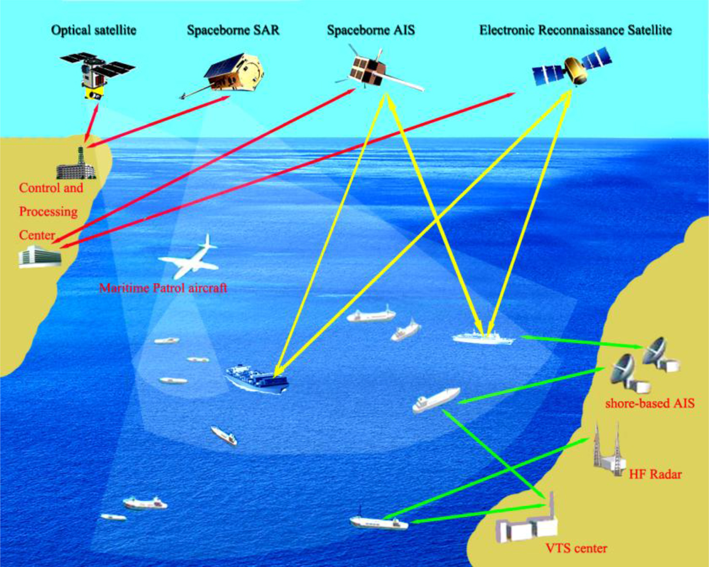
Figure 1. Sketch map for ship surveillance.
This paper aims to present a review of ship surveillance by the integration of space-borne SAR and AIS. The rest of this paper is organized as follows. Section 2 presents an overview of research on ship surveillance by the integration of space-borne SAR and AIS. Section 3 is the constructive discussion. Section 4 concludes the paper with remarks on the future work.
2. REVIEW
To achieve marine security and safety, many countries (Vachon et al., Reference Vachon, English and Woife2007a, Reference Vachon, English and Wolfe2007b; Guerriero et al., Reference Guerriero, Willett, Coraluppi and Carthel2008; Eriksen et al., Reference Eriksen, Skauen, Narheim, Helleren, Olsen and Olsen2010), including Germany, Canada, Norway, Italy, South Korea, and Japan, etc., are making efforts to develop ship surveillance techniques utilising the integration of space-borne SAR and AIS. Much work has already been completed (Lehner et al., Reference Lehner, Brusch and Fritz2009; Eriksen et al., Reference Eriksen, Skauen, Narheim, Helleren, Olsen and Olsen2010). This section reviews this work from the fundamental research, multi-source fusion, applications and engineering perspective.
2.1. Fundamental Research
The fundamental research on ship surveillance using space-borne SAR image validated by AIS reports has already been carried out by scholars and specialists from many institutions; of particular note are the contributions of Defence Research and Development Canada (DRDC) and the German Aerospace Centre (DLR).
Figure 2 shows an example of ship surveillance using space-borne SAR and terrestrial AIS over an area of the Pearl River near Weiyuan and Chuanbi islands in Guangdong, China. (Ship picture source: MarineTraffic.com).

Figure 2. Ship surveillance results by integration of space-borne SAR and terrestrial AIS.
Vachon et al. (Reference Vachon, Dragošević, Kashyap, Liu, Schlingmeier, Meek, Potter, Yue and Kraft2006) have conducted significant research, presenting a series of technical memoranda for DRDC. Experiments for ship surveillance using space-borne SAR and AIS have been carried out. They analysed the results in detail, presenting a report on results for Polar Epsilon by analysing polarimetric ship signatures from the Maritime Sensor Integration Experiment (MARSIE) using CV-580 polarimetric SAR (as a proxy sensor for Radarsat-2 polarimetry) and AIS. DRDC Ottawa carried out three SAR/AIS data acquisition trials, focusing on Radarsat-1 Fine mode, Radarsat-1 ScanSAR Narrow B mode and the Envisat Advanced Synthetic Aperture Radar (ASAR) Alternating Polarization (AP) mode for high-density shipping regions, including the Dover Strait, the Strait of Gibraltar and the Busan Strait.
Adaptive processing of Radarsat-1 fine mode data using CHASP-like (Chip-based Adaptive Synthetic aperture radar Processor) algorithms to estimate ship parameters validated by AISLive data, has been investigated (Vachon and Dragošević, Reference Vachon and Dragošević2007). Ship signatures for Radarsat-1 ScanSAR narrow B imagery with AISLive data have also been analysed, and the fusion of space-borne SAR image signatures of ships with AIS data has been demonstrated as straightforward, providing unprecedented insights to the observed ship signatures (Vachon et al., Reference Vachon and Dragošević2007). They derived new Radar Cross Section (RCS) models from the aforementioned SAR/AIS ship signature validation trials and demonstrated that cross-polarization of space-borne SAR is a better choice for ship surveillance (Vachon et al., Reference Vachon, English and Woife2007a, Reference Vachon, English and Wolfe2007b).
Validation of ship signatures in Envisat ASAR AP mode data over the Dover Strait and the Strait of Gibraltar using AISLive was presented by Vachon and Wolfe (Reference Vachon and Wolfe2008). They also researched the estimations of ship velocity by adaptive processing of single aperture Radarsat-2 data of the Strait of Gibraltar, and validation was carried out against coastal AIS data, which also indicated that ship velocity estimation is feasible for single aperture SAR in the presence of a visible ship wake signature, which could be useful for tracking ships that are not transmitting AIS data (Vachon and Dragošević, Reference Vachon and Dragošević2009).
Liu and Meek (Reference Liu and Meek2005) researched the algorithms, features and implementation of the likelihood ratio test polarimetric SAR (PolSAR) ship detection method and validated the results using ground truth data from AIS. Horn and Zegers (Reference Horn and Zegers2010) investigated near real-time multi-sensor fusion for cued reconnaissance through operational analysis of operation “driftnet 09” using three surveillance platforms (two separate remote sensing satellites including Radarsat-2 and space-based AIS from COM DEV, and the CP-140 airborne platform), produced decision aids to allow effective and valid use of Radarsat-2 ship length data for aircraft cuing, and enhanced the amount of relevant data available from AIS contacts.
Likewise, the researchers from DLR and other institutions have also completed much valuable work. Brekke et al. (Reference Brekke, Weydahl, Helleren and Olsen2008) investigated ship traffic monitoring using multi-polarization Envisat ASAR images combined with AIS reports. A common knowledge base of SAR ship signatures for certain polarizations and incidence angles was built up by combining ships detected in SAR images with ship parameters given in AIS reports from the existing coastal chain in Norway.
Grasso et al. (Reference Grasso, Mirra, Baldacci, Horstmann, Coffin and Jarvis2009) presented a procedure to evaluate the performance of ship detection algorithms for Radarsat-2 data sets of different acquisition modes, which were collected in the Mediterranean Sea. The results were validated by ground-truth AIS data. Holsten et al. (Reference Holsten, Tobehn and Borowy2009a, Reference Holsten, Tobehn and Borowy2009b) indicated the necessity of global maritime surveillance with space-borne AIS and SAR, which contributes to a significantly enhanced maritime safety and security picture. Saur et al. (Reference Saur, Estable, Zielinski, Knabe, Teutsch and Gabel2009) studied the detection and classification of man-made offshore objects in TerraSAR-X and RapidEye imagery, in which ship monitoring in the Dover Strait based on TerraSAR-X StripMap and AIS was investigated.
Hannevik et al. (Reference Hannevik, Olsen, Skauen and Olsen2010) studied ship detection using high resolution Radarsat-2 Standard Quad-Pol imagery, shore-based and space-based AIS data acquired over the Malangen area close to Tromsø city in the north of Norway. Paes et al. (Reference Paes, Lorenzzetti and Gherardi2010) investigated ship detection off the Brazilian coast using TerraSAR-X ScanSAR mode images of HH and VV polarizations, validated by the AIS data provided by AISLive.com and the Brazilian Navy.
Brusch et al. (Reference Brusch, Lehner, Fritz, Schwarz, Lehner and Hamidi2011a, Reference Brusch, Lehner, Fritz, Soccorsi and Schie2011b) investigated ship surveillance by the joint use of TerraSAR-X, shore-based and space-based AIS in the North Sea, Baltic Sea, Atlantic Ocean and Pacific Ocean, and demonstrated that shore-based and space-borne AIS show good agreement with ships detected by TerraSAR-X. Space-borne AIS and SAR are perfect candidates to fill the ship information gap in the open oceans. Chaturvedi et al. (Reference Chaturvedi, Yang, Song, Shanmuagm and Ouchi2011) researched preliminary techniques to integrate SAR and AIS for ship detection and identification. Baumgartner et al. (Reference Baumgartner and Krieger2011) investigated vessel monitoring in the Strait of Gibraltar and the port of Halifax in Canada using TerraSAR-X, TanDEM-X images and ground-truth AIS data. Parameter estimations were also evaluated by comparisons with the AIS references.
Marino et al. (Reference Marino, Walker, Hajnsek and Zürich2012) presented perturbation analysis for maritime applications using Radarsat-2 full polarimetric data performed in Portsmouth and ground-truth AIS data. Watagawa et al. (Reference Watagawa, Kobayashi and Wakabayashi2012) proposed a methodology for the monitoring of vessel traffic by matching AIS data to Advanced Land Observing Satellite (ALOS) images, collected in the Straits of Malacca and Singapore. They evaluated the performance of ship detection and length estimation from satellite imagery, comparing with the reference data derived from AIS information. Renga et al. (Reference Renga, Graziano, D'Erric, Moccia and Cecchini2012) presented an analysis of ship detection algorithms for potential application in a future ship detection facility, which would make use of SAR images of the Gulf of Naples gathered by COSMO/SkyMed, aided by AIS information. Yang et al. (Reference Yang and Kim2012) studied the integration of SAR and AIS for ship detection and identification, and conducted experiments using TerraSAR-X images acquired over Incheon port and AIS data.
2.2. Multi-source Fusion
Ship surveillance by the integration of multiple sensors, including space-borne SAR, AIS, optical, infrared and hyper-spectral sensors, etc., has the potential to achieve high accuracy and efficiency, and is anticipated to play an ever increasing role in maritime surveillance, as research and development progresses.
The multi-source fusion of SAR, optical satellite, AIS and Vessel Monitoring Systems (VMS) has been further investigated. Gabban et al. (Reference Gabban, Greidanus, Smith, Anitori, Thoorens and Mallorqui2008) researched ship surveillance by the integration of TerraSAR-X (ScanSAR mode), AIS, and VMS over the Netherlands' western sea, and demonstrated that in the case of the AIS carrying larger vessels, it was not difficult to detect them, and the size and heading derived from the SAR image mostly compared well with AIS data. Palubinskas et al. (Reference Palubinskas, Reinartz, Brusch and Lehner2009) studied the joint use of TerraSAR-X, WorldView-1 and AIS data for ship detection and tested near real time alerting/maritime situational awareness application to solve tracking problems in high-density traffic regions. Yang et al. (Reference Yang and Kim2012) investigated the validation of ship detection by the integration of Radarsat-1 (Fine mode), AIS and VTS (Vessel Traffic Services).
HF (High Frequency) radar, sonar and ground-based maritime radar could also be taken into account. Gurgel et al. (Reference Gurgel, Schlick, Horstmann and Maresca2010) presented an evaluation of an HF-radar ship detection and tracking algorithm by comparison to AIS and SAR data, and concluded that the problem that not all ships operate AIS but may be detected by the radar, (e.g. small fishing boats or other non-cooperative ships) may be solved by using HF-radars and SAR simultaneously. Soloviev et al. (Reference Soloviev, Gilman, Young, Brusch and Lehner2010) investigated measurements in ship wakes using sonar, TerraSAR-X and AIS, and explored wakes of commercial ships in the vicinity of Port Everglades in south Florida. Ship positions and velocity were retrieved using AIS and TerraSAR-X multi-look data. Won and Ouchi (Reference Won and Ouchi2011) investigated the comparison of ship detection algorithms using ALOS-PALSAR, Ground-Based Maritime Radar, and AIS. They conducted experiments in Tokyo bay to test IMLCC (Improved Multi-Look Cross-Correlation) and developed an integrated ship detection and identification system with SAR, ground-based maritime radar and AIS.
The research on fusion model and decision-making is indispensable. Huisman (Reference Huisman2006) presented the use of surveillance technology to support response decision-making and impact assessments considering the integration of space-borne SAR, Side-Looking Airborne Radar (SLAR), ship-borne radar, AIS, IR camera and Laser Fluorescence sensors. Guerriero et al. (Reference Guerriero, Willett, Coraluppi and Carthel2008) developed a model for multi-sensor fusion and Bayesian anomaly detection that quantifies the value of sensor data for maritime surveillance performance. A notional closed-loop maritime surveillance system using multi-sensor fusion of SAR, AIS, coastal radar, video and infrared (IR), etc., was also proposed.
2.3. Applications
The applications for ship surveillance by the integration of space-borne SAR and AIS have been investigated but further, other, more challenging applications have also been investigated.
It is important to trace the polluter after an ocean oil accident. Uiboupin et al. (Reference Uiboupin, Raudsepp and Sipelgas2008) researched the detection of oil spills from SAR images, identification of polluters and forecast of the slicks' trajectory, using SAR images from the Estonian coastal area and Seatrack web model, that includes AIS data to provide a possibility of identification of a polluters.
Lehner et al. (Reference Lehner, Brusch and Fritz2009) researched the potential for joint use of TerraSAR and AIS in the monitoring of river estuaries and maritime surveillance of a piracy area to evaluate possibilities and limitations of a near real time service in anti-piracy operations. An example of a hijacked ship (Sirius Star) was successfully tracked by integration of TerraSAR-X and space-borne AIS.
Posada et al. (Reference Posada, Greidanus, Alvarez, Vespe, Cokacar and Falchetti2011) investigated maritime awareness for counter-piracy in the gulf of Aden using AIS data from the Maritime Safety and Security Information System (MSSIS), space-borne AIS data from four space-borne AIS systems (SpaceQuest-AprizeSat and ComDev-NTS provided by exactEarth, OrbComm and Pathfinder provided by LuxSpace), space-borne SAR data from Envisat-ASAR, Radarsat-2, TerraSAR-X and Cosmo-Skymed, and Long Range Identification and Tracking (LRIT) data plus some optical ALOS images. They found that it is very difficult to perform a proper fusion of reported and non-cooperative data, and indicated that future expansion of Satellite-AIS constellations, or indeed satellite SARs that also carry AIS receivers, will be needed to achieve a viable capability.
2.4. Engineering
With respect to the applications in engineering, many projects for maritime surveillance have already been developed, and some typical cases are illustrated below.
Firstly, considering the US and European cases, Maritime Domain Awareness (MDA) is related to applications including maritime traffic control, smuggling, illegal fishing, oil dumping and pollution, illegal immigration and anti-piracy monitoring. The US proposed a Global Maritime Awareness concept integrating SAR satellites, AIS micro-satellites, airborne radars, ship radars and surface radars. International collaboration presented the C-SIGMA (Collaboration in Space for International Global Maritime Awareness) concept using commercial satellite technology to realize automatic processing characterized by low cost, rapid availability, wide coverage and flexible choice.
Europe has developed several projects such as GMES (Global Monitoring for Environment and Security), MARISS (Maritime Security Services) and EMSA (European Maritime Safety Agency). The MARISS project integrates space-borne SAR, optical satellites, Long Range Identification and Tracking (LRIT) and coastal radars, etc. (Koichi, 2012). The success of MARISS allows the promotion of a scaling-up phase. The main concern was the development of operational services that integrate cooperative polls from AIS with layers of information derived from SAR image processing (ESA, 2010).
The German Aerospace Centre (DLR) started the DeMarine Security Project in cooperation with OHB, Gauss and the German Weather Service (DWD) to show the fields of application concerning safety and security of coastal and sea traffic as well as coastal protection. ShipDetec, Parol and DEKO are three subprojects of DeMarine Security. ShipDetec focuses on the development of SAR processing algorithms and ship detection by the integration of TerraSAR-X and AIS (DLR et al., Reference DLR2010). Additionally, SAINT (SAR AIS INtegrated Toolbox) was developed by DLR with the integration of TerraSAR-X, terrestrial AIS and Satellite AIS.
BOOST Technologies of France focused on the monitoring of the marine environment using remote sensing data, and developed SARTool software including SARTool Oil, Wind, Ships, and Waves to produce marine products derived from SAR. Monitoring of marine oil pollution uses SAR images coupled with AIS in ship polluter identification (Kerbaol, Reference Kerbaol2006).
LIMES (Land and Sea Integrated Monitoring for European Security) was developed by Europe, and is an integrated project that feeds into the GMES Program (EMIS, 2013) and is applied to the surveillance of the EU borders (land and sea), surveillance and protection of maritime transport of sensitive cargo and protection against emerging security threats. It implements maritime surveillance based on satellite SAR and the integration of Vessel Monitoring Systems (VMS), AIS, Satellite Communications (SATCOM), other vessels and aircraft data (Giovanni, Reference Giovanni2008).
The DECLIMS (Detection and Classification of Marine Traffic from Space) project was led by the Joint Research Centre (JRC) and united 24 international partners involved in ship detection using remote sensing imagery. This project indicated that the value of ship detection using remote sensing imagery is maximized when the results are fused with data from other sources such as VMS and AIS (Vachon, Reference Vachon2006).
SUMO (Search for Unidentified Marine Objects), developed at the JRC, is a software package for automatic detection of vessels by space-borne SAR imagery, regularly used during seasonal campaigns to monitor fishing activities in national or European control operations (Palubinskas, Reference Palubinskas, Reinartz, Brusch and Lehner2009). GMV (Global Maritime Ventures) Aerospace developed a ship-monitoring system with three modules (coastline isolation, ship detection and classification) by integrating the reports provided by AIS with ship related information derived from SAR data processing.
Canada started the Multi-Sensor Integration within a Common Operating Environment (MUSIC) Technology Demonstrator Project (TDP), divided between DRDC's Atlantic and Ottawa laboratories earlier in this century. It was established to demonstrate the capabilities for surveillance data fusion within the Canadian Navy's Recognized Maritime Picture (RMP) and was limited in its ability to effectively fuse surveillance data, and to identify a suitable, scalable computing architecture in which such fusion of dissimilar sources could take place, such as space-borne SAR, High Frequency Surface Wave Radar (HFSWR), ships' radars, AIS, Aircraft and Uninhabited Aerial Vehicles (UAV) (Helleur, Reference Helleur, Rafuse and Campbell2004).
DRDC developed the Geospatial Assessment Software Tool Kit to deliver military solutions. Commercial Satellite Imagery Acquisition Planning System and Image Analyst Pro software complement OceanSuite™ and are used to deliver a complete geospatial assessment in port and harbour monitoring, search and rescue, disaster management and damage assessment, and maritime and arctic safety and security. OceanSuite™ software includes three programs (Ocean Works, Ocean Winds and Ocean Oil) running under Microsoft's Windows operating system and analysing single-polarization Radarsat and Envisat imagery. It has the ability to receive other sources of ship position such as AIS for correlation with the RADARSAT-based ship detections. It accepts NMEA (National Marine Electronics Association) and OTH-G (Over-the-Horizon-Gold) AIS messages, which are fused with RADARSAT ship detections, and then sends integrated OTH Gold messages to Marine Security Operations Centre (Tunaley, Reference Tunaley and Higginson2007).
The Radar Data Exploitation (RDE) Group at DRDC develops and demonstrates software tools for target detection, target recognition, and change detection, based on image and data fusion of space-borne SAR and AIS, etc. The software tools developed consist of Image Analyst Pro (IA Pro), Commercial Satellite Imagery Acquisition Planning System (CSIAPS) and Chip-based Adaptive SAR Processor (CHASP).
Japan Mitsubishi Space Software Co. Ltd., collaborated with JAXA to develop HuygensWorks® characterized by high accuracy and effectiveness, which focuses on ship detection, classification and identification by integration of ALOS/PALSAR, Pi-SAR-L and AIS (Arii, Reference Arii2011).
Additionally, Margarit et al. (Reference Margarit, Barba and Tabasco2009a, Reference Margarit and Mallorqui2009b, Reference Margarit, Milanés and Tabasco2009c) presented the operative Ship Monitoring with SAR (SIMONS) system integrating space-borne SAR data and transponder polls (mainly AIS) to show accurate ship monitoring capabilities with added-value information layers. Ross et al. (Reference Ross, Arifin and Brodsky2011) designed SDIS (Ship Detection and Identification System), integrating many existing data sources which are readily available either commercially or through partnerships with governmental organisations including space-borne SAR, AIS, VMS/LRIT, acoustic underwater and electric field detector, ship-based and coastal radar, to mitigate the maritime issues. Arifin et al. (Reference Arifin, Ross and Brodsky2011) researched data security in SDIS, using a data-at-rest approach and encrypting the data streams within SDIS at all stages including transmission, storage and in-use. Yang et al. (Reference Yang and Kim2012) presented the concept of Integrated Ocean Surveillance System (IOSS) for ship detection and identification by the integration of SAR, optical remote sensing, coastal-based marine radar, AIS and VTS, and designed the system. They also indicated that the study underway is to develop an operational automatic system for different SAR sensors with different acquisition modes and polarizations with different acquisition geometry and different acquisition time to acquire satellite AIS datasets for validation purposes.
3. DISCUSSION
The research on ship surveillance by the integration of space-borne SAR and AIS is significant to marine security. However, the sensors used for ship surveillance all have their own disadvantages, and surveillance based on a single sensor system could not satisfy the increasing requirements. Much benefit could be derived from the cooperative integration of multiple sensors.
Another problem to be considered is the efficiency of ship surveillance. How to acquire real-time surveillance results is a major concern of most users. Firstly, it is worth noting that AIS has also been placed on SAR platforms as a secondary payload to overcome the limit of time lag between SAR image and AIS data acquisition, so employing multiple sensors on the same satellite is one approach. Rubin 7-AIS had been installed on the SAR-Lupe 3 satellite launched in 2007 for military reconnaissance applications (Gunter Space, 2013). Radarsat Constellation Mission (RCM) with three satellites, with an emphasis on near real-time maritime surveillance, ecosystem monitoring, and disaster management, will have a C-band SAR and an AIS on each satellite (ESA, 2013). The second generation of TerraSAR-X may carry two possible secondary payloads including space-borne AIS and TIR (Thermal Infra-Red) (Höllisch, et al., Reference Höllisch, Bach, Janoth and Selegrad2010). Secondly, to develop a satellite constellation plan is also practical. As illustrated above, ORBCOMM and the US Navy Laboratory have their own AIS constellation plans to shorten the no-coverage periods. Of course, the development of SAR constellations, such as RCM is also worthwhile, but deployment timescales will be long. To deal with the urgent affairs, if possible, a combination of multiple state-of-the-art SARs (such as TerraSAR, Radarsat, Cosmo-skymed, etc) may be practical to shorten the no-coverage periods.
4. CONCLUSION
This paper reviews current research into ship surveillance using integrated space-borne SAR and AIS. The fundamental research projects are likely to detect or identify ships using a SAR image, validated by AIS, but there are not currently systematic theories on the data fusion of space-borne SAR and AIS. How to acquire accurate fusion results using effective decision rules needs to be investigated further. For the applications, some scholars have already researched oil polluter tracking and anti-piracy operations, etc. However, they have discovered that more difficulties exist in multi-source data fusion due to the limited development of sensors and the non-cooperative data formats. Additionally, engineering also needs to be developed further to better satisfy the increasing demands.
ACKNOWLEDGEMENTS
This work is supported partly by the National Natural Science Foundation of China under Grant 61240058. The authors would like to thank the anonymous reviewers for their very competent comments and helpful suggestions.


