


INTRODUCTION
The two invasions of Anglesey under Paulinus in a.d. 60 or 61 and Agricola in a.d. 73, described by Tacitus, are rare examples of events in the Roman campaigns in north Wales which have a geographically identifiable location, namely the shores of the Menai Strait which runs between the island of Anglesey and the mainland of north-west Wales. Tacitus records that ‘a garrison was imposed on the conquered natives’ after Paulinus’ victory, implying at least a temporary fortification had been constructed.Footnote 68 Both invasions would almost certainly have entailed the use of temporary camps. The subsequent Flavian consolidation of north Wales involved the construction of a network of auxiliary forts and roads that extended into the wilds of upland Snowdonia. It is almost certain that this extended into the resource-rich island of Anglesey. Despite this, Davies’ comprehensive review of Roman Anglesey, written in 2012, recorded no military sites associated with either of the invasions or the subsequent Flavian consolidation.Footnote 69 The only sites listed on Anglesey were a fourth-century naval base and watchtower at Caer Gybi (Holyhead).
Gwynedd Archaeological Trust has undertaken a series of projects, mostly grant-aided by Cadw, which have re-examined the Roman archaeology of north-west Wales using geophysical survey, excavation and examination of both aerial photographs and LiDAR.Footnote 70 This paper summarises information from three sites on Anglesey: a settlement at Tai Cochion, a fortlet at Cemlyn Bay and a watchtower at Pen Bryn-yr-Eglwys (fig. 3); all were investigated subsequent to Davies’ review. Full results have been published elsewhere.Footnote 71
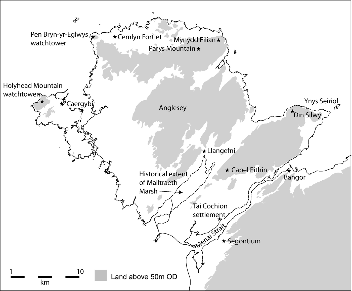
FIG. 3. Roman Anglesey.
TAI COCHION
GEOPHYSICAL SURVEY
Extensive geophysical survey was undertaken in fields running down to the Menai Strait at Llanidan in response to historic finds of Roman material and a recent spate of finds by metal-detectorists reported to the Portable Antiquities Scheme.Footnote 72 The site lies on the opposite shore of the Menai Strait to the auxiliary fort of Segontium (Caernarfon). Some 19.6 ha was surveyed with a Bartington Grad601 gradiometer, revealing a complex settlement extending for 590 m along a road running from the shore (fig. 4). The road is flanked by a series of small sub-rectangular enclosures, typically c. 40 m by 20 m, delineated by small ditches. Most of those close to the road contain rectangular buildings, c. 25 of which can be identified with certainty. Most have a simple elongated rectangular plan with a few incorporating additional rectangular elements. They are all of roughly similar size, c. 16 m by 8 m. No obvious higher-status building is identifiable that would have acted as a settlement nucleus. The southern part of the settlement comprises regular rectangular plots each with a single building, implying a degree of central planning. The area north of the road is less regularly laid out, suggesting ad-hoc development. The enclosures at the north of the survey, with one exception, do not appear to contain buildings and are best interpreted as agricultural fields. The edge of the settlement and its associated activity is generally clear, being defined by the outer extent of the field boundaries with nothing to suggest any significant defences.

FIG. 4. Tai Cochion settlement, interpretation from geophysical survey.
A large sub-circular, double-ditched, defended settlement was detected just north of the road at the western end of the Roman remains. Its foundation almost certainly pre-dates the invasion and may indicate that the slightly meandering Roman road adopted the line of an existing Iron Age trackway running from a convenient landing place on the shore of the Menai Strait. There is no dating evidence from the settlement, so use or reuse in the Roman period cannot be ruled out. A possible parallel is provided by the Roman ‘small town’ at Cowbridge in the Vale of Glamorgan, where the adjacent hillfort of Caer Dynnaf also appears to have been used throughout the Roman period.Footnote 73
EXCAVATION
Two of the rectangular buildings and their surroundings were investigated in community excavation projects run by Gwynedd Archaeological Trust. The first building, excavated in 2010, was a simple 20.2 m by 6.8 m structure with fragmentary stone foundations, which had supported a wood-framed, wattle-and-daub superstructure. It was destroyed by fire, probably in the fourth century, and comprehensively plundered for useful material. The absence of broken slate or tile from the destruction horizons, suggests that the roofing was either thatch or wooden shingles. The disturbed remains contained little stratified material, though associated pottery dated from the mid/late second century to mid-fourth century.
The road identified in the geophysical survey was 7.5 m wide and was separated from the building by a gravel-surfaced yard. A six-poster granary and several pits were identified on the north-west side of the excavation, along with a ditch, 1.7 m wide and 0.5 m deep, defining the edge of the plot that had silted up during the third century.
The second building, excavated in 2011, was somewhat larger (26 m by 7 m) and more complex than that excavated in 2010 (fig. 5). The basic construction was similar with a wood-framed, wattle-and-daub superstructure set on a limestone block foundation. The centrally placed entrance, 2.7 m wide, was imposing, with a substantial covered porch. A portico or corridor probably extended along the south-eastern side, while there was a secondary narrow entrance and internal stone bench along the north-west side. This appears to be a basic Roman corridor-house.Footnote 74 Pottery and coin evidence indicate that it was constructed in the early second century and had a mixed domestic and commercial function, as a concentration of shattered Lezoux colour-coated beakers in the burnt levels probably represents the stock of a shop.Footnote 75

FIG. 5. Tai Cochion settlement, building excavated in 2011.
The sampled areas were only a small part of an extensive site, but finds from both confirmed a similar date-range, providing clear evidence of occupation between the mid-second and mid-fourth centuries. The later fourth-century ceramic forms found at Segontium were notably absent.Footnote 76
The excavated material indicates that the settlement was wealthy, particularly when compared with other sites in north-west Wales, and that a wide range of activity took place including grain processing, blacksmithing, agriculture and trade in pottery and other goods. The settlement is a 3.2 km sea-crossing away from Segontium and it was probably established as a trading point once the political and military situation stabilised a few decades after the invasion. The admittedly limited evidence from developer-led excavations around Segontium indicates that some areas were abandoned between the mid-second and later fourth century, so it is possible that the settlement took over some of the functions of its vicus.Footnote 77
Military vici represent the only widespread Roman settlement type throughout all but the south-east of Wales and typically comprise densely-packed strip-buildings set end-on to a road.Footnote 78 The settlement morphology at Tai Cochion more closely resembles settlements found in more ‘Romanised’ areas of England. It is undefended, covers an area of c. 14 ha and comprises relatively high-status buildings set in large rectangular plots; it has no parallels throughout most of Wales and the western seaboard of Britain. In the context of south-eastern Britain it would be described as a large village or ‘local centre’, i.e. a largely civilian, market settlement, under Hingley's Reference Hingley1989 classification of smaller settlements.Footnote 79 In the context of Roman north Wales it is a high-status settlement and might fall within Burnham and Wacher's admittedly broad classification as a ‘small town’.Footnote 80
The presence of a wealthy undefended settlement that survived for at least 200 years at some distance from Segontium reflects an evolution in the relationship between the Roman military and the local population. The initial overtly military presence, with a network of roads and forts throughout north and west Wales, saw major changes in the second century with forts being reduced in size and abandoned as Roman rule became accepted, however reluctantly. By the mid-second century Segontium was the only fort still in use in north Wales and even here the construction of a courtyard building inside the fort in the Antonine periodFootnote 81 suggests an increasingly administrative role.
The 250 years of apparently uneventful co-existence after a.d. 150 receives less attention than the well-documented invasions. Roman customs and building styles were not adopted by the majority of the population. Millett's description of ‘landscapes of mutual indifference’ when considering the Roman impact in East Yorkshire (an addition to Mattingly's ‘landscapes of resistance’ and ‘landscapes of opportunity’) would seem to be a good description of the situation throughout much of Wales.Footnote 82 Anglesey, with its high-quality agricultural land and probable copper mining had more trade goods and more opportunity than most in the west to interact with the Romans.Footnote 83 As a result a greater degree of interaction can be seen, perhaps driven by trade via the settlement at Tai Cochion. The material culture of Romano-British settlements on Anglesey is significantly richer than on the mainland, with coins and pottery from the whole Roman period being recovered from settlements across the island.Footnote 84 Roundhouses nevertheless continued to be the norm, though rectangular buildings were increasingly incorporated in settlements from the end of the second century.
Tai Cochion is clearly a Roman-style settlement, though current evidence does not reveal whether it was a simple outgrowth of the Segontium vicus or represented a hitherto unrecognised degree of ‘Romanisation’ of a small area of north Wales. The presence of a six-poster granary, a feature usually found in prehistoric or Romano-British settlements, suggests a degree of integration with the local population. It is possible that, having been founded by a population with close links to Segontium, recognisable perhaps in the regular rectangular plots and buildings to the south of the road, the settlement expanded in a less-controlled manner, in the wake of increasing local integration through enterprise, marriage or attempts to gain social status. While Segontium continued in use until the end of the fourth century, the settlement at Tai Cochion was apparently abandoned in the mid-fourth century. Perhaps the wealthy undefended settlement was too tempting a target for the seaborne raiding that prompted the building of coastal defences in the later part of the century and trading was brought closer to the safety of Segontium on the mainland.
CEMLYN FORTLET
The site, located on a low hill 0.6 km south-west of Cemlyn Bay on the north coast of Anglesey, was first detected as a parch-mark on an aerial photograph taken by local historian Mary Aris in 1990. The area was subsequently investigated by geophysical survey in 2015.Footnote 85 This revealed a fortlet measuring 50 m by 45 m, with an entrance on the northern side. Faint traces of subdivided rectangular buildings were detected in the interior (fig. 6). It was surrounded by a slightly irregular sub-circular enclosure, 74 m in diameter, with an in-turning entrance on the north. A reliable source reported that two coins had been found at the site, one of Nerva (a.d. 96–8) and the second of Hadrian (a.d. 117–38), indicating that the fortlet dates from the post-conquest consolidation.

FIG. 6. Cemlyn fortlet, fluxgate gradiometer survey.
The fortlets at Martinhoe and Old Burrow on the south side of the Bristol Channel appear to provide close morphological parallels to the site. These were dated by excavation to c. a.d. 55–75 and a.d. 43–54 respectively.Footnote 86 Both appear to have been short-lived, with Old Burrow only providing tented accommodation. The outer defences are thought to have been used for lighting signal beacons. These, along with sites at Morwenstow and St Gennys, were built as part of the process of gaining control of the Bristol Channel prior to campaigning in Wales.Footnote 87
The fortlet on Anglesey overlooks Cemlyn Bay, one of the few good landing places on the north coast, and has good views out to sea. It could have functioned as a guide to craft landing at the bay as well as policing access to the northern coast. It lies on the principal shipping route along the coast from Chester and could also have acted as a navigational aid.
PEN BRYN-YR-EGLWYS
Excavations in 2012 examined a potential element in the fourth-century Roman naval presence on the north-west side of Anglesey. A roughly square platform, measuring 9 m by 7 m and defined by a low bank, stands on the highest point of Carmel Head.Footnote 88 Traditionally recorded as the site of a chapel, its small size, alignment and remote location suggest otherwise. Local tradition also records that stone was taken from the site to build a new wing on the local church. Following the excavation of a similar structure on Holyhead Mountain, Crew suggested that the site on Carmel Head represents the site of a second Roman watchtower.Footnote 89 A quadrant of the site was excavated confirming the local tradition of stone being carried from the location, as it had been robbed of all useful stone down to its foundations. The only finds were three sherds of pottery, which were almost certainly Roman though not closely datable.Footnote 90 This somewhat sparse evidence reinforces Crew's suggestion that a second watchtower stood on Carmel Head overlooking the fourth-century naval base at Caer Gybi.
DISCUSSION
All three sites act as a reminder that maritime transport and the control of the coastline were important aspects of the Roman occupation. The Cemlyn fortlet was presumably built after Agricola's sudden attack on AngleseyFootnote 91 and probably served as both a navigational aid or signal station and a point of control. Its presence at a good landing place would have guarded against coastal incursions, but may also have exerted control over the passage of raw materials, such as grain and copper, by sea from the island's northern coast. It is worth noting that a second possible fortlet has been reported at Mynydd Eilian, an eminence on the eastern end of the north coast of the island, where a sub-rectangular, slightly trapezoidal enclosure, measuring slightly less than 50 m on each side, was identified by geophysical survey designed to locate Llys Caswallon, a ‘lost’ site recorded in antiquarian accounts.Footnote 92 Assessment excavation revealed that there were straight-sided buildings with stone footings in the interior, while a small amount of Roman pottery, not closely datable, was recovered.Footnote 93 The case for a Roman origin has been strengthened by metal-detectorist finds from the locality. These comprise finds from two distinct periods: coins of Domitian and Trajan and an ‘Aesica’-type brooch from the late first and early second century; and a nummus/follis from House of Constantine (a.d. 330s) and a ‘fallen horseman’ copy of Constantius II from the mid-fourth century.Footnote 94 This site is located 1 km from the coast and 3 km from Parys Mountain, the main copper lode on the island. This could be interpreted as another point of control for resources on the island in a similar fashion to the Cemlyn fortlet. The later material could indicate that it was also reused and incorporated in a late system of watchtowers.
Maritime defences, built as protection against increasing piracy and raiding, are a feature of late Roman Britain. The fourth-century defences on Anglesey may be installations built under Theodosius in response to the so-called barbarian conspiracy of a.d. 370. A group of sites known as the Yorkshire signal stations, set on headlands facing the North Sea and overlooking potential landing places, are usually attributed to this period,Footnote 95 though Casey offered an alternative, slightly later, origin during the campaign of Maximus against the Picts in a.d. 383.Footnote 96 The watchtowers flanking Caer Gybi might have simply served as look-outs for the naval base, though this would have left the base relatively isolated from the coastal forts at Caernarfon and Chester; it could therefore be argued that the towers had an additional function as part of an early warning system not unlike the Yorkshire installations. A system of watchtowers has been proposed by several authors based on finds of Roman material on prominent points along the coastline.Footnote 97 Towers have been proposed at Din Silwy, Ynys Seiriol (Puffin Island), Bangor, Braich y Dinas and Deganwy, though with the exception of Pen Bryn-yr-Eglwys no structures have been identified. Mynydd Eilian can now be added to this list of possible sites; it should be noted that it has a direct line of sight to Ynys Seiriol at the mouth of the Menai Strait, where a Roman box tile is incorporated into the twelfth-century tower of the church.Footnote 98
The three sites discussed in this paper also have implications for the interpretation of the land-based defences and communication systems of Anglesey. Davies suggests a nearby fort may have been a catalyst for the founding of the Tai Cochion settlement.Footnote 99 Its environs have been examined, however, in some detail using aerial photography and LiDAR and, perhaps more significantly, have been targeted by local metal-detectorists; no indication of any further Roman activity has so far been discovered. It might be suggested that a second fort within 3.5 km of Segontium would have been unnecessary. The crossing point of the Strait may well mark the beginning of a road across the island. All fortlets in Wales lie on the line of Roman roads so, unless the Cemlyn fortlet was entirely supplied and garrisoned by sea, it is possible that a road ran to the north-west of the island.Footnote 100 The most likely route would presumably have avoided Malltraeth Marshes, a tidal inlet that formerly extended half way across Anglesey.Footnote 101 A fort in the centre of Anglesey at the inner end of the tidal inlet, close to the current town of Llangefni, would seem to be a possibility. Ongoing work on an early medieval cemetery during works on the Llangefni link road recovered residual Roman material, including sherds of possibly late first- and definitely second-century date. This included a high proportion of samian that could indicate either high-status or military activity in the area.Footnote 102 Also of note, close to this proposed line, is a probable late first- to early second-century signal station pre-dating the early medieval cemetery at Capel Eithin, Gaerwen.Footnote 103
While much more Roman archaeology remains to be discovered on Anglesey, recent discoveries provide points of reference and add considerably to our understanding of the interaction between the local population and the Roman occupiers. The island clearly had great strategic importance, initially as a last refuge against the coming of Rome and, after its fall, as a prize marking the final subjugation of the troublesome West. It was also important as a source of grain and copper and finally as a link in the coastal defences of Britannia Prima. It is therefore very likely that there is at least one fort and a road system on the island, along with additional coastal defences, as well as the more ephemeral remains from Paulinus’ short-lived campaign. Unfortunately the many centuries of agricultural activity that has seen Anglesey dubbed ‘the breadbasket of Wales’ have resulted in heavily improved land that makes the rediscovery of such sites a slow process.


