


1. Introduction
The SW Grenville Province represents a deeply exhumed ancient collisional orogen with similarities to the modern Himalayas (Windley, Reference Windley, Moore, Davidson and Baer1986). Like the Himalayas, the Grenville Province underwent crustal shortening and gravitational collapse by thrusting, generating a series of sub-parallel high-strain zones. Modern understanding of the history of the orogen has been based on mapping this series of thrusts (Rivers et al. Reference Rivers, Martignole, Gower and Davidson1989). However, detailed mapping has been hampered by high-grade metamorphism, coupled with late extensional shearing, which has tended to overprint earlier convergent structures (Culshaw et al. Reference Culshaw, Ketchum, Wodicka and Wallace1994).
Rivers et al. (Reference Rivers, Martignole, Gower and Davidson1989, Reference Rivers, Ketchum, Indares and Hynes2002) recognized the Allochthon Boundary Thrust (ABT) as the principal locus of crustal shortening during the c. 1080–1040 Ma Ottawan phase of the Grenville Orogenic Cycle, separating a relatively in situ parautochthon to the NW from more far-travelled allochthonous terranes to the SE (Fig. 1). However, it should be noted that in the Grenvillian context, the term ‘allochthonous’ does not mean that these terranes were exotic to Mesoproterozoic Laurentia.
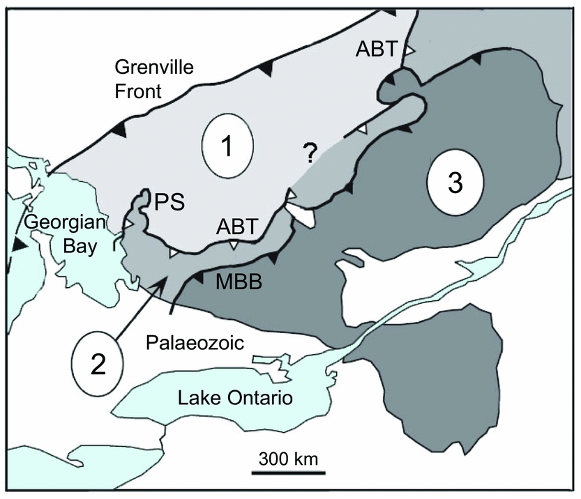
Figure 1. Map of the SW Grenville Province in the Great Lakes region showing structural belts proposed by Rivers et al. (Reference Rivers, Martignole, Gower and Davidson1989): 1 = Parautochthon; 2 = Allochthonous Polycyclic Belt; 3 = Allochthonous Monocyclic Belt. ABT = Allochthon Boundary Thrust; MBB = Monocyclic Belt Boundary; PS = Parry Sound domain. Modified after Rivers et al. (Reference Rivers, Martignole, Gower and Davidson1989).
In Quebec and Labrador, the ABT was localized on the basis of magnetic signatures, which separate the magnetically ‘quiet’ Archaean parautochthon from the magnetically ‘noisy’ Proterozoic allochthon, reflecting the more complex geological history of the latter. However, in Ontario the ABT is located further south within Proterozoic rocks. This location was originally based on recognition of the basal Parry Sound Shear Zone (PSSZ) on the west side of the Parry Sound domain as a major thrust zone. The PSSZ is the most prominent high-strain zone on the Georgian Bay shoreline (Davidson, Culshaw & Nadeau, Reference Davidson, Culshaw and Nadeau1982), and was therefore a likely locus of the ABT. Hence, Rivers et al. (Reference Rivers, Martignole, Gower and Davidson1989) sketched a possible trajectory for the ABT running round the north side of Parry Sound domain (PS, Fig. 1) and then trending eastwards, sub-parallel to the Monocyclic Belt Boundary (MBB, Fig. 1). However, its connection to the ABT in Quebec remained unclear (question mark in Fig. 1).
In their early mapping of the Georgian Bay shoreline, Davidson, Culshaw & Nadeau (Reference Davidson, Culshaw and Nadeau1982) also identified a second, less prominent shear zone c. 10–20 km north of the Parry Sound Shear Zone. This more northerly structure was later referred to by Culshaw et al. (Reference Culshaw, Jamieson, Ketchum, Wodicka, Corrigan and Reynolds1997) as the Shawanaga Shear Zone (SSZ, Fig. 2). It was found to contain mafic pods that were tentatively recognized by Davidson, Culshaw & Nadeau (Reference Davidson, Culshaw and Nadeau1982) as retrogressed eclogite, an identification supported by detailed textural and chemical analysis (Grant , Reference Grant1989). Subsequently, retrogressed eclogites were also recognized at other localities in the Parry Sound region (Ketchum & Davidson, Reference Ketchum and Davidson2000), of which the examples shown by red stars in Figure 2 were verified by Davidson, Nadeau & Culshaw (Reference Davidson, Nadeau and Culshaw2012).
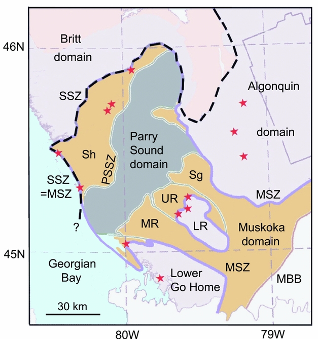
Figure 2. Map of the Parry Sound region showing major shear zones: PSSZ = Parry Sound Shear Zone; SSZ = Shawanaga Shear Zone (bold dashed line); MSZ = Muskoka Shear Zone (solid purple line); MBB = Monocyclic Belt Boundary. Lithotectonic domains: Sh = Shawanaga; UR and LR = Upper and Lower Rosseau. Red stars = retrogressed eclogites. Modified after Culshaw et al. (Reference Culshaw, Foster, Marsh, Slagstad and Gerbi2016).
The Shawanaga Shear Zone was also found to separate two other meta-basic suites with apparently non-overlapping geographical distributions. These are represented by olivine meta-diabase equivalent to 1.24 Ga Sudbury dykes in the northwest, and 1.17 Ga coronitic olivine meta-gabbro in the southeast (Culshaw et al. Reference Culshaw, Ketchum, Wodicka and Wallace1994). The juxtaposition of these non-overlapping suites at the Shawanaga Shear Zone implied that this was a locus of significant tectonic convergence. Hence, Ketchum & Davidson (Reference Ketchum and Davidson2000) concluded that the Shawanaga Shear Zone rather than the PSSZ was the local expression of the ABT.
Based on stacking relationships, it was evident from the early work of Davidson, Culshaw & Nadeau (Reference Davidson, Culshaw and Nadeau1982) that the Parry Sound domain was partially overthrust by other thrust sheets from the SE (the Moon River and Seguin nappes; Fig. 2). However, with the recognition that the ABT is located structurally below the Parry Sound shear zone, it became apparent that the Allochthonous Polycyclic Belt (belt 2 in Fig. 1) has two major structural decks (e.g. Culshaw et al. Reference Culshaw, Jamieson, Ketchum, Wodicka, Corrigan and Reynolds1997, Reference Culshaw, Foster, Marsh, Slagstad and Gerbi2016). The upper deck (Muskoka domain, including Seguin and Moon River sub-domains), is separated from the lower deck (Algonquin domain) by a major shear zone, which we will refer to here as the Muskoka Shear Zone (MSZ, Fig. 2).
This shear zone, which forms the footwall of the Muskoka domain, was the original locus of the ABT proposed by Rivers et al. (Reference Rivers, Martignole, Gower and Davidson1989). However, this model was abandoned by Rivers et al. (Reference Rivers, Ketchum, Indares and Hynes2002) when they chose the more northerly ABT trajectory of Ketchum & Davidson (Reference Ketchum and Davidson2000), shown as a heavy dashed line in Figure 2. On the other hand, it was recently proposed by Culshaw et al. (Reference Culshaw, Foster, Marsh, Slagstad and Gerbi2016) that these two shear zones (SSZ and MSZ in Fig. 2) coincide geographically on the Georgian Bay shoreline and northwards round the Parry Sound domain. Nevertheless, they appear to separate on the east side of the Parry Sound domain, which raises the question of which of these shear zones should be recognized as the principal locus of crustal convergence during Ottawan tectonism.
2. Significance of retrogressed eclogites
The presence of high-pressure rocks such as eclogite in the vicinity of the ABT implies exhumation from the deep crust. This supports the identification of the ABT as a crustal-scale ramp, as first proposed for the eastern Grenville Province (Indares, Reference Indares1993; Rivers, Van Gool & Connelly, Reference Rivers, Van Gool and Connelly1993). Retrogressed eclogites are seen prominently in the vicinity of the ABT on Georgian Bay (red stars in Fig. 2). However, elsewhere in the gneiss belt, the eclogites often occur at structural levels that appear to be far above the assumed ABT trajectory (heavy dashed line, Fig. 2). Of particular interest is their location on a shear zone that separates structurally lower and upper parts of the Rosseau domain (LR, UR, Fig. 2), interpreted by Culshaw et al. (Reference Culshaw, Foster, Marsh, Slagstad and Gerbi2016) as equivalent to the Muskoka Shear Zone. Culshaw et al. refer to this boundary as the Monocyclic Boundary Thrust (based on recognizing the Muskoka domain as having a monocyclic metamorphic history). However, we prefer not to use this term, because the rocks of the Muskoka terrane were formed more than 350 Ma before the Grenville orogeny (Slagstad et al. Reference Slagstad, Culshaw, Jamieson, Ketchum, Tollo, Corriveau, McLelland and Bartholomew2004). Hence, referring to these rocks as monocyclic relative to the Grenville Orogeny can be misleading.
The location of the Rosseau eclogites near a shear zone of equivalent structural level to the Muskoka Shear Zone (Fig. 2) prompts us to reconsider the identity of these boundaries. Based on the association of eclogites with zones of deep crustal exhumation, we propose that the Muskoka Shear Zone represents the principal locus of Ottawan tectonic convergence, and hence the local expression of the ABT. However, this raises questions about the more northerly trajectories of the ABT previously proposed by other workers (e.g. Ketchum & Davidson, Reference Ketchum and Davidson2000; Rivers et al. Reference Rivers, Ketchum, Indares and Hynes2002; Culshaw et al. Reference Culshaw, Foster, Marsh, Slagstad and Gerbi2016) and also by us (e.g. Dickin, Moretton & North, Reference Dickin, Moretton and North2008).
To answer this question, we need to examine the structure of the ABT where it is known with more confidence, such as the Lac Watson area in western Quebec (Fig. 3). This area corresponds to the question mark of Rivers et al. (Reference Rivers, Martignole, Gower and Davidson1989) shown in Figure 1, but was subsequently the subject of a detailed study by Indares & Dunning (Reference Indares and Dunning1997). In this region, these authors mapped three structural decks with distinct lithologies, of which the lower one is Archaean in age, while the upper two are Proterozoic. They found retrogressed eclogite close to a major shear zone between the middle and upper decks, termed the Lac Watson Shear Zone (LWSZ; Fig. 3). Hence the Lac Watson Shear Zone is regarded as the local expression of the ABT, forming the footwall to the Mesoproterozoic allochthon in this area.
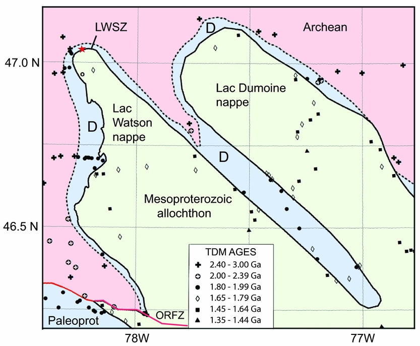
Figure 3. Map of the Lac Watson – Lac Dumoine nappes showing the proposed location of the ABT = Lac Watson Shear Zone (LWSZ) and Palaeoproterozoic duplex (D). ORFZ = Ottawa River Fault Zone. Red star = retrogressed eclogite. Modified after Dickin et al. (Reference Dickin, Cooper, Guo, Hutton, Martin, Sharma and Zelek2012).
Subsequently, Herrell, Dickin & Morris (Reference Herrell, Dickin and Morris2006) showed that the middle deck of this stack had Palaeoproterozoic TDM model ages between 1.8 and 2 Ga, and referred to it as a structural duplex. This duplex was argued to represent parautochthonous crust that was entrained onto the base of the main allochthon by downward propagation of the basal décollement of the thrust sheet. This duplex structure was then shown by Dickin et al. (Reference Dickin, Cooper, Guo, Hutton, Martin, Sharma and Zelek2012, Reference Dickin, Herrell, Moore, Cooper and Pearson2014) to be of widespread distribution around the Lac Watson and Lac Dumoine thrust sheets (D, Fig. 3).
We propose here that the Mesoproterozoic allochthon in the Parry Sound area is underlain by a similar duplex structure that can be identified by Nd isotope mapping. However, the crustal structure in the Parry Sound area is more complex than at Lac Watson, because the Parry Sound domain itself represents a fourth structural deck on top of the main allochthonous thrust sheet (as proposed by Culshaw et al. Reference Culshaw, Jamieson, Ketchum, Wodicka, Corrigan and Reynolds1997). In addition, the lower structural decks in the Parry Sound area have younger crustal formation ages than the Lac Watson area because the more southerly crustal units around Parry Sound were generated outboard of the Archaean craton during the Proterozoic eon.
As a result, the lower deck in the Parry Sound area is predicted to have Penokean TDM ages (1.8–2 Ga), as identified further north by Dickin & McNutt (Reference Dickin and McNutt1989), while the duplex is proposed to have Labradorian TDM ages (1.65–1.79 Ga). Finally, the main allochthon in the Parry Sound region is proposed to have Pinwarian TDM ages (1.45–1.64 Ga), as recently proposed by Dickin & North (Reference Dickin and North2015). The ages of these orogenic events (based on U–Pb dating) have been defined elsewhere in the Mid Continent (Van Schmus, Reference Van Schmus, Morey and Hanson1980) and the Grenville Province (Gower, Scharer & Heaman, Reference Gower, Scharer and Heaman1992; Tucker & Gower, Reference Tucker and Gower1994). In addition, zircon ages in these ranges have recently been obtained by U–Pb analysis of quartzite and metaplutonic units from the Algonquin area (Culshaw et al. Reference Culshaw, Foster, Marsh, Slagstad and Gerbi2016).
3. Sampling and analytical techniques
The objective of Nd isotope mapping is to characterize the protolith age (crustal formation age) of large areas of crust as an indication of the geological relationships between highly metamorphosed lithotectonic terranes. The protolith age is one of the most fundamental features of a crustal terrane, but clearly there are other events in the geological history of terranes that are also indicative of relationships between them.
Another feature that may characterize lithotectonic terranes and domains is their magmatic/plutonic history. In the SW Grenville Province, the most widely distributed igneous crystallization event occurred around 1.45 Ga (Slagstad et al. Reference Slagstad, Culshaw, Jamieson, Ketchum, Tollo, Corriveau, McLelland and Bartholomew2004, Reference Slagstad, Culshaw, Daly and Jamieson2009, and references therein). Rocks with U–Pb ages corresponding to this event are found in most of the lithotectonic domains shown in Figure 2, except for the monocyclic belt in the SE corner. Some older U–Pb ages are also found in the northern part of the study area (Nadeau & van Breemen, Reference Nadeau and van Breemen1998, and references therein). However, these U–Pb ages are much too thinly scattered to be used to map the complexly deformed terrane boundaries in this region. In contrast, Nd isotope analysis represents a cost-effective technique for mapping lithotectonic terrenes, based on the robustness of Nd isotope signatures in highly metamorphosed terranes (e.g. Dickin, Reference Dickin2000). This method allows very high spatial resolution, which is unmatched by any other geological age discriminant.
Since the objective of this study was to characterize the protolith age of the crust as an estimate of its regional crustal formation age, sampling was limited to granitoid orthogneisses that are believed to form by anatexis of more mafic juvenile arc crust. Previous studies have shown that granitoids of this type have Nd isotope signatures that are consistent and predictable, allowing reliable estimates to be made of the formation age of the crust using the depleted mantle model of DePaolo (Reference DePaolo1981).
Tonalitic–trondhjemite–granodiorite (TTG-type) gneisses were sampled where possible, since these are believed to be the best examples of the rock types that form primitive arc crust. More granitic samples were used as a second choice, since these may have a more complex geological evolution, but usually still preserve the original formation age of arc crust. In contrast to granitoid rocks, sampling of mafic gneisses was avoided as far as possible, because of the increased likelihood of a younger mantle-derived component in these rock types. Metasedimentary gneisses were also excluded because of their uncertain sedimentary provenance.
On average, 1 kg of rock was crushed, after the removal of weathered, veined or migmatized material, and careful attention was given to obtaining a fine powder representative of the whole rock. Sm–Nd analysis followed our established procedures. After a 4-day dissolution at 125°C using HF and HNO3, samples were converted to the chloride form before splitting and spiking. Standard cation and reverse phase column separation methods were used. Nd isotope analyses were performed on a VG isomass 354 mass spectrometer at McMaster University using double filaments and a four-collector peak-switching algorithm, and were normalized to a 146Nd/144Nd ratio of 0.7219. Average within-run precision on the samples was ±0.000012 (2σ), and an average value of 0.51185±2 (2σ population) was determined for the La Jolla Nd standard during this work. The reproducibility of 147Sm/144Nd and 143Nd/144Nd is estimated at 0.1% and 0.002% (1σ) respectively, leading to an analytical uncertainty on each model age of c. 20 Myr (2σ), based on empirical experience over several years of analysing duplicate dissolutions. Uncertainties deriving from the Nd mantle model are discussed below.
4. Results
New Nd data for nearly 70 samples from the Parry Sound region are presented in Table 1, where they are used to calculate TDM ages using the depleted mantle model of DePaolo (Reference DePaolo1981). As discussed by Dickin et al. (Reference Dickin, Hynes, Strong and Wisborg2016), this yields formation ages for crustal terranes in the SW Grenville Province that are very well supported by U–Pb dating (Slagstad et al. Reference Slagstad, Culshaw, Jamieson, Ketchum, Tollo, Corriveau, McLelland and Bartholomew2004, Reference Slagstad, Culshaw, Daly and Jamieson2009). Samples are grouped in Table 1 according to the new structural domains proposed in this study, and are shown on a coloured map in Figure 4, where new data points from Table 1 are numbered, whereas published data points are unnumbered (Dickin & McNutt Reference Dickin and McNutt1989, Reference Dickin, McNutt, Gower, Rivers and Ryan1990; Dickin, Moretton & North, Reference Dickin, Moretton and North2008 Slagstad et al. Reference Slagstad, Culshaw, Daly and Jamieson2009; ; Dickin et al. Reference Dickin, McNutt, Martin and Guo2010; Moore & Dickin, Reference Moore and Dickin2011; Dickin & North, Reference Dickin and North2015). However, two published analyses are included in Table 1 because of their strategic location in the newly recognized Proudfoot klippe (see below).
Table 1. Nd isotope data


Figure 4. Map of the Parry Sound region showing proposed new tectonic structure, including the Palaeoproterozoic parautochthon (blue), duplex (violet), Mesoproterozoic allochthon (greens) and Parry Sound klippe (yellow). ABT = Allochthon Boundary Thrust. Domain abbreviations: HH = Honey Harbour; LR = Lower Rosseau; H = Huntsville. Stars = metabasic: red = eclogite; green = coronitic olivine metagabbro (large, dated; small, undated); open = Sudbury diabase equivalent, from Ketchum & Davidson (Reference Ketchum and Davidson2000).
In Figure 4, our four proposed structural decks of the gneiss belt are coloured as follows: blue = Palaeoproterozoic parautochthon; violet = tectonic duplex; green = Mesoproterozoic allochthon; yellow = Parry Sound domain. The main allochthon is coloured in two shades of green to distinguish the segment underlying Parry Sound from the Muskoka segment. These two segments have the same range of model ages (to be demonstrated below) and are believed to have originally been a single thrust sheet that was later broken, so that the more southeasterly Muskoka terrane overrode the northwesterly terrane (Nobel – Ahmic – Upper Rosseau – Upper Go Home domains).
Parry Sound domain is the most significant lithotectonic unit in the study area because of its abundance of mafic rocks. These rocks give rise to a large positive gravity anomaly, up to 35 mGal higher than the surrounding crust (Lindia, Thomas & Davidson, Reference Lindia, Thomas and Davidson1983). This dense crustal unit locally depressed the underlying allochthon, protecting it from erosion and causing it to be preserved as an almost complete ring around Parry Sound domain (green in Fig. 4). The exception to this is the NE side of Parry Sound domain where it abuts nearly against the Powassan batholith. This plutonic body forms most of the large southerly salient of the parautochthon in Figure 4. Based on its negative gravity anomaly, the Powassan batholith probably acted as a buoyant object, pushing the overlying allochthon upwards so that it was removed by erosion.
To the west of Parry Sound domain, a proposed new location for the ABT divides the old Shawanaga domain into two parts. The eastern part is made up largely of the Nobel gneiss (Connare & McNutt, Reference Connare and McNutt1985), and this new unit is therefore termed the Nobel domain (Fig. 4). On the shores of Georgian Bay, the new boundary follows the same trajectory as the ABT proposed by Culshaw et al. (Reference Culshaw, Corrigan, Ketchum, Wallace and Wodicka2004a , Reference Culshaw, Corrigan, Ketchum, Wallace and Wodicka b ) on the Parry Sound and Naiscoot map sheets (P3550, P3549) along the south side of the Shawanaga pluton.
As a result of detailed new sampling, the ABT is now defined on Highway 69 by a clear step in TDM ages (±1.65 Ga) that coincides with the boundary mapped by Culshaw (Reference Culshaw, Corrigan, Ketchum, Wallace and Wodicka2004 a). The boundary passes to the east of an outcrop of coronitic metagabbro (large green star in Fig. 4) that was dated to 1152±2 Ma by Heaman & LeCheminant (Reference Heaman and LeCheminant1993). This shows that this coronitic metagabbro is not located in the main allochthon, but its underlying duplex. Hence, the two metabasic rock suites believed by Ketchum & Davidson (Reference Ketchum and Davidson2000) to be separated by the ABT are actually separated by the sole thrust of the duplex, which we call the Duplex Boundary (dashed line in Fig. 4). Although the Duplex Boundary is not the principal locus of deep crustal exhumation corresponding to the ABT, it is still a zone of significant crustal shortening, as indicated in Figure 3, where the Palaeoproterozoic duplex overrides Archaean basement by at least 200 km.
The ABT was not mapped to the north of Highway 69 by Culshaw et al. (Reference Culshaw, Corrigan, Ketchum, Wallace and Wodicka2004a ). However, we trace it northwards on the west side of Parry Sound domain in Figure 4, where it passes close to two retrogressed eclogite outcrops (red stars), as expected for its role as a crustal-scale ramp. It is also well constrained in the vicinity of Arnstein (Fig. 4), where it passes close to another mapped eclogite body.
To the south of Parry Sound domain, the Lower Go Home and Lower Rosseau tectonic windows have been known for some time (e.g. Davidson, Reference Davidson1995). However, it is notable that a young TDM age in the southern part of Go Home domain (Dickin & McNutt, Reference Dickin, McNutt, Gower, Rivers and Ryan1990) is located within a ring-shaped outcrop of anorthosite bodies that is associated at its northern end with a retrogressed eclogite pod. Anorthosite bodies are characteristic in this region of major terrane boundaries (Davidson, Nadeau & Culshaw, Reference Davidson, Nadeau and Culshaw2012), and the association with retrogressed eclogite also implies crustal exhumation on a thrust zone. Hence these rock types provide strong evidence that this lithotectonic unit (HH = Honey Harbour domain, Fig. 4) represents another tectonic klippe of the allochthon.
The affinity of the surrounding gneisses in the Lower Go Home domain is not yet properly understood. The klippe may be surrounded by a tectonic duplex (violet colour in Fig. 4), but two new samples yield TDM ages >1.9 Ga (nos 10, 11 in Fig. 4), suggesting that the tectonic window reaches through to the underlying parautochthon (blue colour). This is consistent with the polycyclic metamorphic history of the Lower Go Home domain, as noted by Culshaw et al. (Reference Culshaw, Jamieson, Ketchum, Wodicka, Corrigan and Reynolds1997).
A tectonic window was proposed in the Huntsville region by Davidson (Reference Davidson1995), but abandoned in later work (e.g. Ketchum & Davidson, Reference Ketchum and Davidson2000). However, two factors prompted us to re-examine this proposal. Firstly, there is a lack of granulite-facies gneisses in the immediate vicinity of Huntsville, although these are seen in the surrounding domains (Nadeau, Reference Nadeau1991). Secondly, a similar gap is observed in the distribution of coronitic olivine metagabbro (Ketchum & Davidson, Reference Ketchum and Davidson2000), as shown in Figure 4. This petrological evidence for a tectonic window at Huntsville is supported by the new Nd data (Fig. 4), with several TDM ages >1.8 Ga characteristic of the Palaeoproterozoic parautochthon. Additional evidence for old protolith ages in the Huntsville domain comes from a 1714+123/−71 Ma upper intersection age for zircon cores from the Hillside granitic orthogneiss (Nadeau & van Breemen, Reference Nadeau and van Breemen1998). This unit was collected as sample #7 in the present study, with a TDM age of 1.79 Ga (Table 1). The observation of many horizontal foliation directions to the E and NE of Huntsville (Lumbers & Vertoli, Reference Lumbers and Vertoli1996) is consistent with the existence of a structural dome. This area is also characterized by a large number of sub-horizontally oriented straight gneisses (Nadeau, Reference Nadeau1991). Hence we suggest that the ABT was originally located almost immediately above the present land surface in this area.
We also propose the existence of two additional outliers of allochthonous rocks (tectonic klippen) to the east of Parry Sound domain, located within Bethune and Proudfoot townships (Fig. 4). When combined with the units discussed above, these form a series of NW-directed allochthonous terranes at 30–40 km intervals, including two large nappes (Moon River and Seguin) flanked by smaller klippen on either side (Honey Harbour and Bethune–Proudfoot) (Fig. 4). The distribution of these klippen reflects late Grenvillian corrugation of the thrust sheet (Rivers & Schwerdtner, Reference Rivers and Schwerdtner2015; Culshaw et al. Reference Culshaw, Foster, Marsh, Slagstad and Gerbi2016). However, the greater degree of preservation of the Moon River and Seguin nappes is attributed to the dominant role of the Parry Sound domain in down-buckling the local crust, giving them more protection against uplift and erosion.
A consequence of this new structural model is that the Algonquin domain to the east is now recognized as an expression of the tectonic duplex (Fig. 4). Therefore, far from being a thick crustal slice, as proposed by Culshaw et al. (Reference Culshaw, Foster, Marsh, Slagstad and Gerbi2016), Algonquin domain is inferred to be a quite thin-skinned unit that comprises a corrugated sub-horizontal thrust sheet. This implies that Algonquin domain could be perforated by additional tectonic windows and carry additional allochthonous klippen that have not yet been mapped.
5. Discussion
The ranges of model age data for the main structural domains proposed above are summarized in the form of stacked histograms and probability density curves in Figure 5, where the three main structural decks are distinguished using the same colours as in Figure 4. It is important to emphasize that these sample suites are geographically defined. However, based on the boundaries identified above, the distribution of Nd model ages in each of these terranes can be examined in order to understand their geological history.
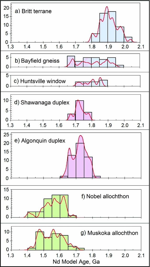
Figure 5. Histograms and probability density curves for TDM model ages of lithotectonic units of the Parry Sound region from Table 1 and published data (Dickin & McNutt, Reference Dickin, McNutt, Gower, Rivers and Ryan1990; Dickin, Moreton & North, 2008; Slagstad et al. Reference Slagstad, Culshaw, Daly and Jamieson2009; Dickin et al. Reference Dickin, McNutt, Martin and Guo2010; Moore & Dickin, Reference Moore and Dickin2011; Dickin & North, Reference Dickin and North2015).
The oldest model age suite is found in the Palaeoproterozoic Parautochthon, using a data compilation previously discussed by Dickin, Moretton & North (Reference Dickin, Moretton and North2008). The data form a tight symmetrical distribution of model ages with a frequency maximum at 1.9 Ga (Fig. 5a). This distribution is consistent with crustal extraction as a juvenile arc terrane shortly before the 1.85 Ga Penokean orogeny, and it validates our use of the depleted mantle model of DePaolo (Reference DePaolo1981) to calculate Nd crustal formation ages.
The youngest Nd model age suite, seen in the allochthon, includes data from Table 1, Dickin, Moretton & North (Reference Dickin, Moretton and North2008), Slagstad et al. (Reference Slagstad, Culshaw, Daly and Jamieson2009), Dickin et al. (Reference Dickin, McNutt, Martin and Guo2010) and Dickin & North (Reference Dickin and North2015). These suites, from the Muskoka terrane (Fig. 5g) and the Nobel and Ahmic domains (Fig. 5f), have similar age ranges from c. 1.4 to 1.7 Ga. The lower end of this distribution is consistent with the widespread 1.45 Ga magmatic event in the study area (Slagstad et al. Reference Slagstad, Culshaw, Jamieson, Ketchum, Tollo, Corriveau, McLelland and Bartholomew2004), but model ages >1.55 Ga are suggestive of incorporation of a small fraction of Palaeoproterozoic crustal material. This can be explained by the development of an ensialic arc on the older continental margin, in which mixing of older and younger components occurred (Dickin & McNutt, Reference Dickin, McNutt, Gower, Rivers and Ryan1990; Slagstad et al. Reference Slagstad, Culshaw, Daly and Jamieson2009).
Samples from the Shawanaga and Algonquin duplexes (Table 1; Dickin & McNutt, Reference Dickin, McNutt, Gower, Rivers and Ryan1990; Dickin, Moretton & North, Reference Dickin, Moretton and North2008; Moore & Dickin, Reference Moore and Dickin2011) form an intermediate model age peak around 1.7 Ga (Fig. 5d, e). Some U–Pb crystallization ages similar to this value are known to the north of the study area (Corrigan, Culshaw & Mortensen, Reference Corrigan, Culshaw and Mortensen1994). However, due to the large amount of crust that has been cut out by Grenvillian thrusting, it is not known whether the 1.7 Ga Nd model ages in the duplex are indicative of a discrete 1.7 Ga crustal formation event that occurred on the continental margin, or a mixture of 1.9 Ga and 1.5 Ga components in an ensialic arc.
It is notable that the three domains with the largest sample suites, comprising Britt, Algonquin and Muskoka domains (Fig. 5a, 5e, 5g), have minimal overlap in TDM ages. This supports the interpretation of these three domains as distinct structural decks, juxtaposed by Grenvillian tectonism from an originally wider continental margin (e.g. Dickin & McNutt, Reference Dickin, McNutt, Gower, Rivers and Ryan1990; Slagstad et al. Reference Slagstad, Culshaw, Daly and Jamieson2009). However, because the thrust stack was generated by oblique telescoping of the older margin, it is expected that the allochthon and the underlying duplex will both gradually get older to the NE (compare TDM ages in Fig. 4 with Fig. 3). This can explain why some ages within the Bethune and Proudfoot klippen (Table 1) are slightly over the normal range of ages seen in the Muskoka and Nobel domains to the south and west.
Nd data for the Bayfield gneiss assemblage (Culshaw et al. Reference Culshaw, Ketchum, Wodicka and Wallace1994) to the west of the ABT on Georgian Bay tell a more complex story (Fig. 5b). These rocks have been recognized by all workers as parautochthonous, but were found by Dickin & North (Reference Dickin and North2015) to have TDM ages as low as 1.65 Ga. As a result, Dickin and North interpreted them as magmatically reworked parautochthon. However, the interfingering of reworked and less-reworked Palaeoproterozoic gneisses in this area may result from the near-coincidence of the Shawanaga and Muskoka shear zones on Georgian Bay. This would likely have resulted in local imbrication of the tectonic duplex, whose magmatically reworked Nd signatures reflect a more outboard origin than the earlier continental margin recognized in the parautochthon. This local imbrication may explain the location of eclogite pods in the footwall of the ABT in this vicinity, whereas elsewhere they are located in the hangingwall.
The range of TDM ages in the Huntsville window (Table 1; Fig. 5c) shows that it has model ages slightly younger than the parautochthonous Britt domain, but older than the Bayfield assemblage (Fig. 5b). This is expected if the Huntsville window represents a southerly equivalent of Britt domain, which experienced moderate Mesoproterozoic magmatic reworking, but less than the crustal segment that later formed the duplex. In fact, two rocks from within the perimeter of the Huntsville window (samples 5 and 8; Table 1) have significantly younger TDM ages than the other samples. These could be attributed to a greater degree of magmatic reworking of the protoliths, but alternatively these rocks could sample a sliver of the duplex that has been preserved in this locality on top of the parautochthon. The inferred sub-horizontal attitude of the ABT in this area is consistent with the ramp–flat structural model of Dickin et al. (Reference Dickin, Herrell, Moore, Cooper and Pearson2014).
6. Tectonic synthesis
These new interpretations of the tectonic structure of the Parry Sound region are put into the wider context of the SW Grenville Province in Figure 6a. This map shows the somewhat unique influence of Parry Sound domain in loading down the allochthon, but it also shows the repetitive distribution of allochthonous nappes and klippen, with an approximate spacing of 30–40 km. Rivers & Schwerdtner (Reference Rivers and Schwerdtner2015) proposed that the Muskoka Shear Zone can be traced eastwards to form the nappe-shaped Wallace sub-domain. We have shown this structure in Figure 6a (marked ‘W’), However, their proposed trajectory must be modified on the eastern side of the Wallace nappe due to Nd evidence for a large salient of parautochthonous Palaeoproterozoic rocks in this vicinity.

Figure 6. (a) Proposed new tectonic map of the SW Grenville Province. Bn = Bethune klippe; W = Wallace sub-domain; TMBSZ = Twelve Mile Bay Shear Zone; red lines = antiformal fold axes; blue lines = synformal fold axes; red stars = retrogressed eclogites dated by Marsh & Culshaw (Reference Marsh and Culshaw2014). X–X = line of section. (b) Cross-section along line X–X with no vertical exaggeration. Red stars = retrogressed eclogites.
The distribution of lithotectonic domains in Figure 6a leads us to extend the mapping of late Grenvillian fold axes previously summarized by Schwerdtner & Van Berkel (Reference Schwerdtner and Van Berkel1991) and recently updated by Schwerdtner et al. (Reference Schwerdtner, Rivers, Tsolas, Waddington, Page and Yang2016). Blue lines in Figure 6a indicate synforms occupied by nappes and klippen, whereas red lines indicate antiforms partially breached by windows. These features show good parallelism except in the vicinity of Parry Sound, and possibly the Powassan batholith, which seem to have acted as rigid blocks, resisting NE–SW compression and causing the fold axes to form a fan-shaped pattern.
The unique influence of the Parry Sound domain in down-loading the allochthon can be seen on a cross-section (Fig. 6b), which cuts across the Parry Sound and Rosseau domains along the anticlinal fold axis X–X (Fig. 6a). This cross-section follows close to the Lithoprobe 31 reflection profile (White et al. Reference White, Easton, Culshaw, Milkereit, Forsyth, Carr and Davidson1994), which therefore provides detailed evidence for the crustal structure along this section (see also Strong, Reference Strong2015). As discussed by Dickin et al. (Reference Dickin, Herrell, Moore, Cooper and Pearson2014), the reflection profile shows that the ABT was down-warped under the Parry Sound domain, returning towards the surface in the Lower Rosseau domain, which forms a structural dome (Lumbers & Vertoli, Reference Lumbers and Vertoli2000). This dome appears to consist of a parautochthonous core that is surrounded by a rim of the duplex (Fig. 4). Hence, in the cross-section in Figure 6b, the duplex is shown as a continuous sheet under the footwall of the allochthon, whose main ramp corresponds to the Muskoka Shear Zone.
We comment finally on the possible timing of movement on the shear zones discussed in this study. Early work by van Breemen et al. (Reference van Breemen, Davidson, Loveridge, Sullivan, Moore, Davidson and Baer1986) pointed to c. 1150 Ma ages for movement on the Parry Sound Shear Zone (PSSZ, Fig. 2). This age was confirmed by Krogh & Kwok (Reference Krogh and Kwok2005) and Marsh et al. (Reference Marsh, Gerbi, Culshaw, Johnson, Wooden and Clark2012), who showed that this was also the date of metamorphism on the Twelve Mile Bay Shear Zone (TMBSZ; Fig. 6a). The latter forms the footwall to Parry Sound domain on its southern side, where it overlies the Upper Go Home domain (Fig. 4).
Hence we suggest that the Parry Sound domain was first emplaced onto what is now the main allochthon in the 1190 – 1150 Ma Shawinigan event (Rivers, Reference Rivers1997). However, Parry Sound domain was transported further to the NW during the main 1080–1040 Ma Ottawan event. This is demonstrated by the c. 1090 Ma U–Pb ages on a subset of the eclogite bodies (stars in Fig. 6a) dated by Marsh & Culshaw (Reference Marsh and Culshaw2014). The chemistry of these zircons indicates growth within an eclogite assemblage, interpreted to date high-pressure metamorphism of these rocks immediately before major uplift on the ABT crustal-scale ramp.
Metamorphism on the Shawanaga Shear Zone (approximately following our Duplex Boundary) is mostly associated with late extensional tectonics (c. 1020 Ma; Ketchum & Krogh, Reference Ketchum and Krogh1998). However, this motion must have been preceded by NW-directed thrusting, since the duplex has younger TDM ages than the parautochthon, indicative of a more outboard origin. The age of this NW-directed thrusting is not well constrained, but 1035 Ma monazite ages in Britt domain (Jamieson, Culshaw & Corrigan, Reference Jamieson, Culshaw and Corrigan1995) suggest that it occurred a few Ma earlier, possibly around 1040 Ma. This northward younging of U–Pb ages was summarized by Culshaw et al. (Reference Culshaw, Jamieson, Ketchum, Wodicka, Corrigan and Reynolds1997), and is consistent with progressive down-cutting of the basal décollement over time. It is comparable with the progressive down-cutting of Himalayan thrusting over the past 20 Ma (DeCelles et al. Reference DeCelles, Robinson, Quade, Ojha, Garzione, Copeland and Upreti2001).
Acknowledgements
We thank Steve and Caroline Edmondson for hospitality at their cottage during several episodes of fieldwork in support of this project. We also appreciate the support of the Geological Magazine’s editor and comments by Peter Cawood and an anonymous reviewer that helped improve the manuscript.


