
One cannot speak of any kind of ‘tourist’ interest in Libya before the twentieth century. There were ‘travellers’, to be sure; but these were hardy individuals bent on the discovery of unknown geographies at the price of considerable discomfort, and bear no comparison to the leisured ‘Grand Tour’ of Europe already indulged in by the wealthier classes from the eighteenth century onwards. It was only in the 1930s, under Italian colonial rule, that foreign tourists (mostly Italian) came to Libya on any scale. At that time, the Italians were keen to demonstrate their domination of the country and to show off, not only its exotic geography (such as desert oases) but the excavated remains of a classical past which – in their eyes – showed how Roman (i.e. Italian) rule had once made the country great and would surely do so again. The Italians built asphalt roads and hotels, and produced a guidebook under the authoritative imprint of the Touring Club Italiano (Bertarelli Reference Bertarelli1929). There were also a couple of archaeological guides to individual sites (e.g. Bartoccini Reference Bartoccini1927a, Reference Bartoccinib).
This development was of course brought to a complete halt by the occurrence of the Second World War. Following the Allied victory in North Africa in 1943, there continued to be British troops in Libya with a certain amount of leisure time to fill. It was felt important that these should be guided to appreciate the presence and importance of the ancient monuments, in order that they should not thoughtlessly damage them. Once a British Military Administration had been set in place, including Antiquities Officers, and peace had been established, two brief guides to antiquities in English were published, for Tripolitania and Cyrenaica respectively (Haynes Reference Haynes1945; Hyslop and Applebaum Reference Hyslop and Applebaum1945: see Figure 1). The foreword to the latter explains simply and clearly the motivation behind it. ‘The necessity of bringing out this book while it can still be of use to the Allied Forces has overridden other considerations and no apology is made for inaccuracies or omissions. The guide has been prepared without the opportunity of referring to many valuable authorities and without the time essential for production of a scholarly work … Please assist the work of conservation by not damaging or defacing the monuments, which are the heritage of the civilized world.’

Figure 1. Hyslop and Applebaum's guide to Cyrenaica, 1945.
The Tripolitania guidebook went through a number of editions and reprints. In its last manifestation (Haynes Reference Haynes1965: see Figure 2) it contained a historical summary (down to the Arab conquest in the mid-seventh century AD), with separate chapters on Lepcis Magna, Oea (Tripoli) and Sabratha and a broad survey of ‘outlying sites and monuments.’ The Cyrenaica guide had no direct successor, but a modest volume by R. G. Goodchild (Reference Goodchild1959), limited to describing the monuments of Cyrene and Apollonia, went through three editions, the last of which was published in 1970.

Figure 2. Denys Haynes’ guide to Tripolitania, 1965 reprint (a well-used copy).
In the 1960s and 1970s there was some development of international tourism to Libya and there were, of course, many expatriates based in the country and working in petrochemicals and other major development projects. There were also visits by occasional Swan Hellenic cruises. However, as the Libya of Muammar Qadhafi increasingly incurred the animosity of foreign powers, culminating in the imposition of United Nations sanctions in 1992, tourism dwindled away to nothing and there was no call for new or updated guidebooks.
All of this changed very suddenly when sanctions were lifted in 1999 and it became possible, once again, to fly into and out of Libya. There was immediate public interest and, before long, two of the new generation of guidebook publishers had produced volumes to meet the demand of the growing Anglophone tourist trade. (This did not include holders of American passports, who were barred by their own administration from visiting Libya until just a few months before the 2011 revolution.) These new guides (Footprint, Azema Reference Azema2000; Lonely Planet, Ham Reference Ham2002) reflected the market of the time: relatively light on cultural interest, with rather more on ‘getting the feel’ of a place. Ham's Lonely Planet guide went into a second edition in 2007. Neither of these publications covered more than the principal sites, and those were often covered by Lonely Planet with a casual disregard for real understanding which almost insulted the reader. (I am not concerned here with guidebooks in other languages, but note in passing the appearance of significantly better (archaeological) guides in Italian and German. See Dal Bosco and Grassi Reference Dal Bosco and Grassi1998–2005; Willeitner Reference Willeitner2001–11.)
In 2005, I entered this environment as a leader of cultural tours. I was asked to produce lists of recommended reading material and came very rapidly to feel that new accounts of the archaeology were required, not only to meet the needs of those already flocking to visit the (deservedly) popular coastal sites, but also to demonstrate to travel companies that the country had much more to offer the cultural tourist than the standard fare that almost all of them were providing. (This was typically Tripoli, Sabratha and Lepcis Magna; Ptolemais, Qasr Libya, Cyrene and Apollonia; with more exotic extensions to Ghadames or to the rock-art of the Fazzan.) It was also apparent to me that there was a desperate paucity of any sort of decent written material in Arabic which might encourage the Libyan population itself to learn about and respect its cultural heritage. If I were to put something together, perhaps in due course it might be translated into Arabic for wider use. (A local guide on one of the sites told me in this context that to publish in English would be quite sufficient, since they had very largely to work in English – but this rather missed the point.)
I therefore resolved to do something about this, and approached some of the publishers of what might be termed ‘the more respected’ cultural guidebooks; but, while interested, none of them was prepared to make a commitment to a Libya guidebook. However, the Society for Libyan Studies very rapidly embraced the idea of an archaeological guidebook (which would have a much longer shelf-life than a general guide). This would also sit nicely with the recent creation of the Society's Silphium Press imprint, intended for popular volumes, the sale of which would cover their production costs, and with the wish of the Society's major funder, the British Academy, that the Society should engage not only in research but also in ‘outreach’. It was further suggested that Libya should be tackled in perhaps three sections, starting with Tripolitania and then moving on to Cyrenaica and the Fazzan.
The literature to be tackled before making any foray into the field was not vast. The major sites have never ceased to be a focus, both of new research and of progressive publication of earlier work. While teams from a number of countries have worked in Libya since independence in 1951, the Italians are to be commended for the strenuous efforts they have made in recent years to make good the paucity of earlier publication of the extensive excavations carried out during the years of colonial rule. The sites in the interior are a rather different matter. Many were summarily recorded when Richard Goodchild was exploring and compiling his maps of Roman Libya in 1950–51 (Goodchild Reference Goodchild1954a, Reference Goodchildb) and some were treated in journal articles by Goodchild and others. In Tripolitania, field survey was carried out by Olwen Brogan and then subsequently in the hugely influential UNESCO Libyan Valleys Archaeological Survey. Following Goodchild's work, no comparable field survey has been published for Cyrenaica (I understand that there was a plan for an Italian team to do this at the time of the UNESCO project), but another very important source of information was a magisterial volume on Cyrenaican architecture by Sandro Stucchi (Reference Stucchi1975). This is a volume to be used with caution (see the reviews by S. Walker in Journal of Roman Studies 68, 1978, 222–3 and by D. White in The Art Bulletin 59, 1977, 623–6), but it does have the merit that Stucchi had visited, described and illustrated a huge number of rural sites in addition to the principal ancient cities.
These sources, therefore, provided the background to a process of selection, based on the state of preservation (and intelligibility) of sites, along with their intrinsic interest and practical accessibility. Accessibility has, of course, increased hugely since the 1950s and the present network of asphalted roads has transformed a landscape, much of which used to require sturdy 4 × 4 vehicles. Buildings which used to be remote are now, in some cases, ‘just beside the road’ (see Figures 3 and 4). A further issue to be resolved in the case of rural sites was that, in the older reports, locations were described in terms (such as old maps, no longer available, or schools and police stations which no longer exist) which were no longer very helpful. Happily, however, it was possible in many instances to find the sites by searching satellite imagery before having to look for them on the ground (see Figure 5). It was even possible to map out routes on unmade tracks to reach some of them.
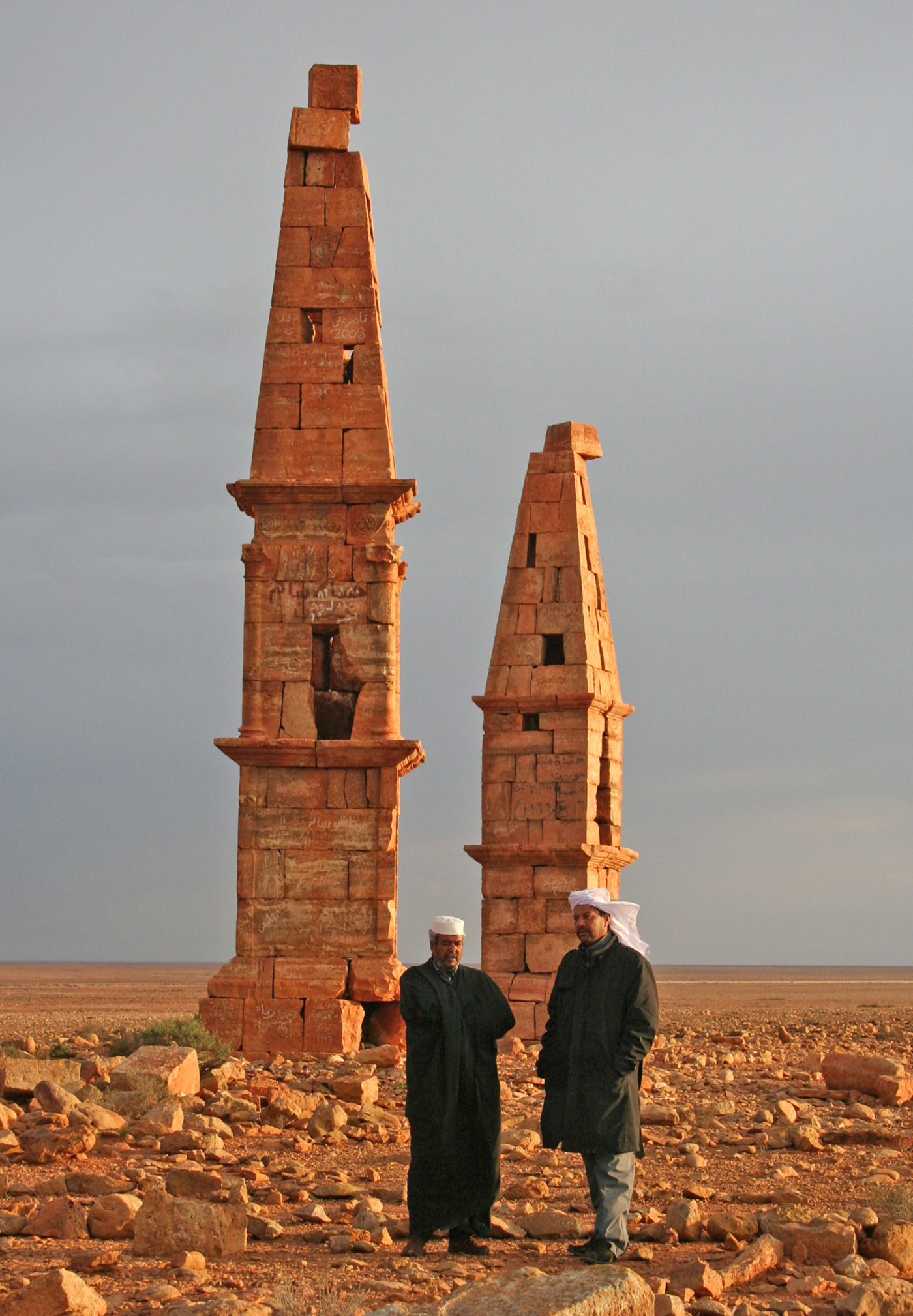
Figure 3. Obelisk-tombs of Roman date at Msallatin, to the E of Bani Walid (Kenrick Reference Kenrick2009, 195). These are now less than a kilometre from an asphalt road. (Photograph: Sue Kenrick)

Figure 4. Mqayrnis (Mghernes: Kenrick Reference Kenrick2013, 303–6), a little-known settlement site close to Cyrene and easily accessible. This is a bath-building, provisionally attributed to the sixth or seventh century AD, the vaulted and domed roofs of which are still in place. (Photograph: Philip Kenrick)

Figure 5. Qasr ar-Rimthayat (Gasr er-Remteiat: Kenrick Reference Kenrick2013,312–4). Previous information gave a tantalising but brief description and ‘35 km due south of Cyrene’ as a location (Goodchild Reference Goodchild and Reynolds1976, 200). On this basis it was possible to identify the site on satellite imagery (a: image dated 26 Sept. 2003, from Google Earth) and to find it on the ground (b: photograph Philip Kenrick) even though it is still more than 8 km from the end of the nearest road.
Armed, therefore, with a draft text and with this information, I was greatly aided by friends at Wings Travel and Tours to make a reconnaissance of Tripolitania in January 2008, to plot locations and navigational instructions using a GPS device and so to refine the text and provide supporting illustration. A concomitant of the rapid building of roads has been a complete absence of road signs and a significant lag in the availability of trustworthy road maps; the provision of GPS data seemed therefore the only way to be sure of guiding the tourist to his or her destination.
The Tripolitania guide (Kenrick Reference Kenrick2009: see Figure 6) was an immediate success: income from sales had recouped the Society's outlay in its entirety within 18 months. Work was therefore started on Cyrenaica and a field trip was made in the autumn of 2010, this time with the direct support of the Department of Antiquities, and particularly of Mr. Ahmad Buzaian, Lecturer in Archaeology at the University of Benghazi, with very wide knowledge of the territory. The richness of the archaeological heritage in Cyrenaica is such that the ground could not be covered in a single visit. However, the planning of a second was inevitably delayed by the fighting which broke out in February 2011 and did not come to an end until October of that year.

Figure 6. Cover of the Tripolitania archaeological guide.
In the following spring, my contacts in Libya indicated that it would be ‘safe enough’ to make a return visit, and in April 2012 I did this with great success. It was clear that the country was in a fragile state, with no effective central authority; but it was also clear at that time that the population at large was immensely pleased with the change in circumstances. I was keen to complete a job that had been started, and was hopeful that, when the governance of Libya had settled down, there would be ever greater opportunities for cultural tourism and the employment that it would bring to an increasingly educated and under-employed local workforce. I was also hopeful that a much wider range of tours might be developed, with knowledge of some of the lesser, but very interesting, surviving ancient monuments that could be visited without difficulty. Indeed, I had myself devised a new tour of Tripolitania and Fazzan which was due to take place in the spring of 2011, but which was of course cancelled at short notice. The Cyrenaica guide in due course also found its way into print (Kenrick Reference Kenrick2013: see Figure 7).

Figure 7. Cover of the Cyrenaica archaeological guide.
While incoming foreign tourism remains for now a very distant hope, the objective to make better information available to Libyans themselves remains. Back in 2008, while the Tripolitania guide was going through the press, Shell Exploration and Production Libya GmbH offered to finance the production of an Arabic translation of it, in a print-run of 3,000 copies of which 1,000 would be gifted to the Libyan people for free distribution (primarily to schools, universities and government departments). The text had been prepared and was nearly ready to go to press in 2011, at which point it was agreed that printing should be delayed until the dust had settled and it was clear that the volume could in practice be disseminated as intended. By November of that year Shell Libya had ceased to exist (or at least ceased to communicate). Roughly two years later, a new promise of funding was obtained from the World Bank (through the effective intervention of the Society's Head of Mission, Professor Paul Bennett) and finally in 2015 the book was printed in Tunis, and 3,000 copies were sent by truck to the Department of Antiquities in Tripoli as a gift. The process has been a challenging learning experience for all of those involved, but there is evidence that it has been a success (see Figure 8).

Figure 8. The Arabic edition of the Tripolitania guidebook in use in the field in 2016 (downloaded from the Internet).
Following this experience, the Society has embarked on the translation of the Cyrenaica guide and, at the time of writing, this is well under way. It can surely only be beneficial to the preservation of the antiquities of Libya that the Libyan population themselves (particularly landowners and government planners) should have a fuller understanding of them and a greater interest in their continued existence. This is also in conformity with the aim of the Society for Libyan Studies ‘to advance, encourage, support and undertake the study of, and research relating to, history, antiquities, culture, languages, literature, art, institutions, customs and natural history of Libya.’
The Fazzan region has not hitherto been mentioned; it is obviously desirable that it should receive the same treatment, but this cannot be done until the region is safely accessible and a check can be made on the current state of the known antiquities.


