INTRODUCTION
Central Macedonia in northern Greece is bordered by the northern Aegean Sea to the south, the lower Strymon valley to the east, and the lower Aliakmon valley to the west. The region is dominated by the Thessaloniki Plain and surrounding mountains and comprises also the Mygdonia (Langadas) basin and the Chalkidiki peninsula. Research has indicated the occurrence of two basic types (with variations) of prehistoric settlement in this region (Kotsakis, Reference Kotsakis1999; Andreou et al., Reference Andreou, Fotiadis and Kotsakis2001). First, flat extended settlements are characterized by very shallow stratigraphy and habitation over a wide area (attributable to lateral expansion of habitation through time), sparse arrangement of houses, often partly subterranean, and large empty spaces between houses (Grammenos et al., Reference Grammenos, Pappa, Urem- Kotsou, Skourtopoulou, Giannouli and Tsigarida1990, Reference Grammenos, Pappa, Urem- Kotsou, Skourtopoulou, Giannouli, Marangou, Valamoti, Syridis and Christidou1992; Pappa and Besios, Reference Pappa and Besios1999; Pappa, Reference Pappa2007, Reference Pappa2018). Such sites existed throughout the Neolithic period (~6700–3300 BC) and gradually disappeared during the earlier part of the third millennium BC. Second, tell settlements are characterized by deep stratigraphy because of vertical expansion of habitation through time, in situ rebuilding of houses, superposition of successive habitation deposits, and relatively densely spaced houses. Such settlements, known as toumbas in central Macedonia, coexisted with the flat extended sites during the Neolithic, sometimes very near to each other, and continued to be occupied into the Bronze Age (~3300–1030 BC) (Andreou and Kotsakis, Reference Andreou and Kotsakis1994; Pappa et al., Reference Pappa, Nanoglou and Efthymiadou2016, Reference Pappa, Nanoglou and Efthymiadou2017). During the second millennium BC, it is likely that toumbas were the only type of habitation site in the region. During this period, toumbas acquired the very characteristic form, specific to central Macedonia, of a high, small (rarely up to 1 ha), steep-sided, conical mound. Archaeological deposits within toumbas vary from a few to 20 m in depth (Andreou, Reference Andreou2001). Research has focused primarily on the economic, social, and symbolic aspects of life in the prehistoric settlements of central Macedonia to interpret the differences between the two patterns of habitation (Andreou and Kotsakis, Reference Andreou and Kotsakis1994; cf. Chapman, Reference Chapman1994; Kotsakis, Reference Kotsakis1999). The relative importance of the role of environmental or cultural factors in tell formation continues to be debated (cf. Rosenstock, Reference Rosenstock2012).
Recent geomorphic processes often hinder investigations into prehistoric societies—for example, because of the overlying deposition or erosion that are common in the alluvial plains and valleys of central Macedonia (Krahtopolou, Reference Krahtopolou2010). The landscape of prehistoric habitation in central Macedonia has been radically transformed over the past 8000 yr (e.g., Syrides et al., Reference Syrides, Albanakis, Vouvalidis, Pilali-Papasteriou, Papaefthimiou-Papanthimou, Ghilardi, Fouache, Paraschou and Psomiadis2009). Although the Late Bronze Age toumbas remain prominent in the modern landscape because of their morphology, the Neolithic flat, extended settlements may disappear under thick layers of alluvial deposits. A good example of such changes in central Macedonia has been documented in the Thessaloniki Plain where much paleogeographic and archaeological research has been focused (Bottema, Reference Bottema1974; Bintliff, Reference Bintliff1976; Vouvalidis et al., Reference Vouvalidis, Syrides and Albanakis2005; Ghilardi et al., Reference Ghilardi, Fouache, Queyrel, Syrides, Vouvalidis, Kunesch, Styllas and Stiros2008a, Reference Ghilardi, Kunesch, Styllas and Fouache2008b, Reference Ghilardi, Genc, Syrides, Bloemendal, Psomiadis, Paraschou, Kunesch and Fouache2010, Reference Ghilardi, Psomiadis, Cordier, Delanghe-Sabatier, Demory, Hamidi, Paraschou, Dotsika and Fouache2012; Syrides et al., Reference Syrides, Albanakis, Vouvalidis, Pilali-Papasteriou, Papaefthimiou-Papanthimou, Ghilardi, Fouache, Paraschou and Psomiadis2009; Psomiadis et al., Reference Psomiadis, Ghilardi, Demory, Delanghe-Sabatier, Bloemendal and Yiu2013). This research and others in adjacent areas (e.g., Lespez et al., Reference Lespez, Tsirtsoni, Darcque, Koukouli-Chryssanthaki, Malamidou, Treuil, Davidson, Kourtessi-Philippakis and Oberlin2013 for Dikili Tash) also demonstrated the significant potential of multidisciplinary geoarchaeological methods for reconstructing environments of prehistoric habitation in this region (e.g., Nea Nikomedeia: Bintliff, Reference Bintliff1976; Ghilardi et al., Reference Ghilardi, Psomiadis, Cordier, Delanghe-Sabatier, Demory, Hamidi, Paraschou, Dotsika and Fouache2012; Archontiko: Syrides et al., Reference Syrides, Albanakis, Vouvalidis, Pilali-Papasteriou, Papaefthimiou-Papanthimou, Ghilardi, Fouache, Paraschou and Psomiadis2009; Pella: Ghilardi et al., Reference Ghilardi, Fouache, Queyrel, Syrides, Vouvalidis, Kunesch, Styllas and Stiros2008a).
The Anthemous River valley, which lies at the opposite (eastern) side of the Thessaloniki Bay, has not been subjected to any complementary paleogeographic study despite its rich archaeological context (Fig. 1). Surface reconnaissance and excavations have been conducted in this region since the beginning of the twentieth century (Wace, Reference Wace1914; Rey, Reference Rey1921; Heurtley, Reference Heurtley1939; French, Reference French1967, Grammenos, Reference Grammenos1991; Pappa, Reference Pappa2007, Reference Pappa2018). The Anthemous Valley Archaeological Project (AVAP) is the most recent comprehensive study of prehistoric settlement in the area and was conducted by collaboration between Greek and Polish scientists. The project focused on settlement patterns from the Middle Neolithic to the Early Iron Age (5800–700 BC). Combined intensive and extensive archaeological field surveys with the use of geographic information system, geophysics, and other multidisciplinary approaches were undertaken (Andreou et al., Reference Andreou, Pappa and Czebreszuk2016a, Reference Andreou, Pappa and Czebreszuk2016b). Particularly significant in this study was Toumba Nea Raedestos, one of the largest, best-preserved, and long-lived settlement mounds in the valley.
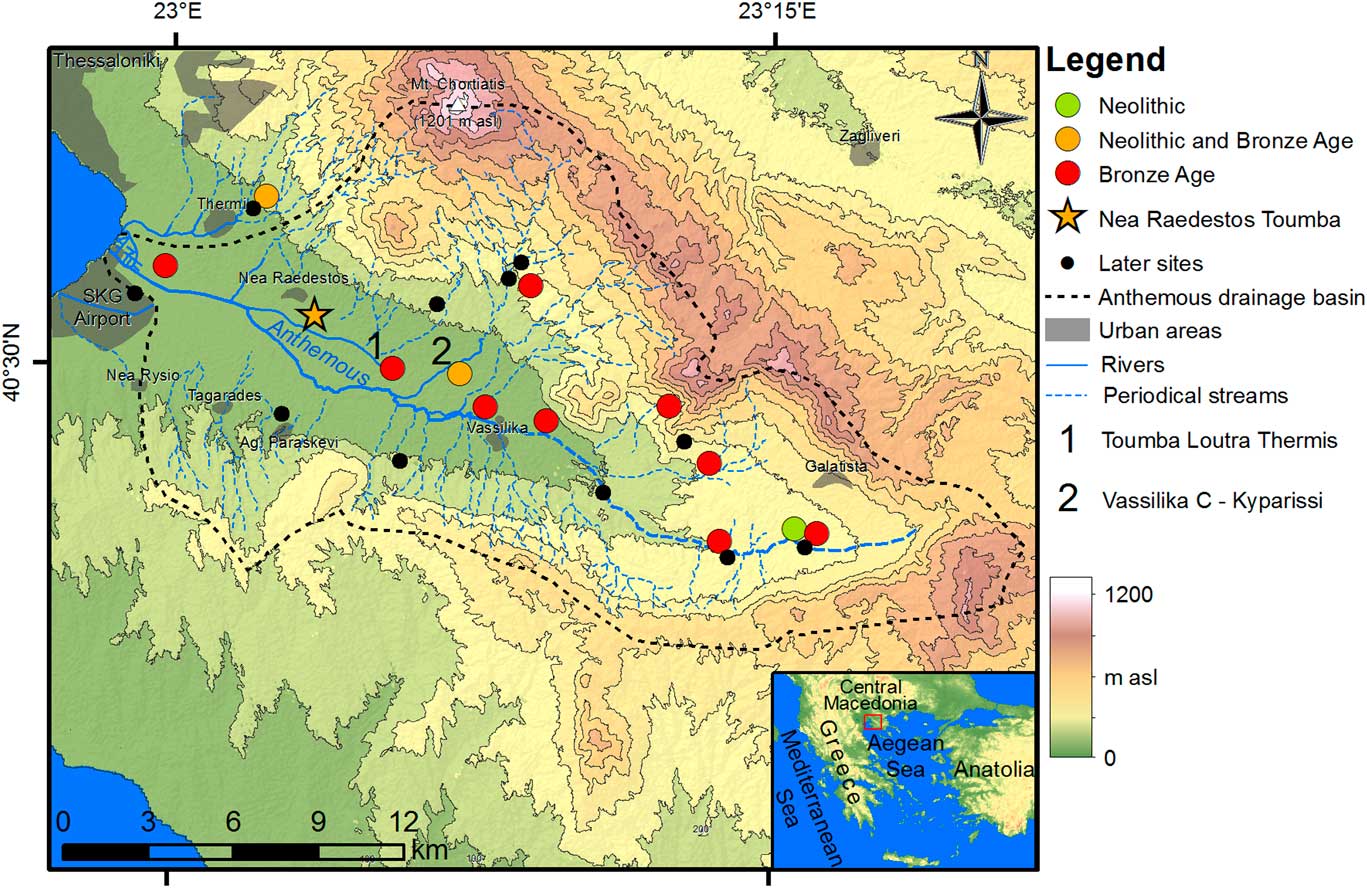
Figure 1. (color online) Anthemous valley hypsometry (ASTER Digital Elevation Model Grid, product of METI and NASA, obtained from usgs.gov map service) with archaeological sites shown (on the basis of Anthemous Valley Archaeological Project data). 1, Loutra Thermis; 2, Kyparissi. Spatial reference WGS1984 (dd mm ss.ss). m asl, meters above sea level.
The survey conducted by the AVAP confirmed earlier suggestions, based on pottery collected from the surface, that occupation spanned the period from the Late Neolithic to Late Bronze Age (French, Reference French1967) and extended these dates, both earlier and later, to the Middle Neolithic and Iron Age, respectively (~5800/5600 BC, fifth/fourth century BC). The presence of some Neolithic pottery on the tell surface, higher than its visible base, provided an initial indication that the tell formation process had started at the site before the Bronze Age. This could not be confirmed, however, without information regarding the depth and extent of the Neolithic deposits beyond the limits of the base of the mound.
The main aim of our geoarchaeological study was to reconstruct the relationship between episodes of landscape change and prehistoric human occupation in the area of Nea Raedestos within the broad regional context of the Thessaloniki Plain. A second objective was to test the archaeological stratigraphy of the site, reconstructing the postdepositional processes that obscured the archaeological visibility of the earlier phases of habitation. The latter objective also aimed to understand the depositional processes related to the earlier phases of the site (i.e., if the habitation during the Neolithic was similar to the pattern of the Bronze Age tell or was instead a flat, extended settlement). Either was possible because both settlement types coexisted during the Neolithic period in the Anthemous River valley (Grammenos, Reference Grammenos1991; Pappa, Reference Pappa2007, Reference Pappa2018; Andreou et al., Reference Andreou, Pappa and Czebreszuk2016a, Reference Andreou, Pappa and Czebreszuk2016b). To achieve these goals, the stratigraphy of the archaeological site and its environmental context were investigated.
THE STUDY AREA
Geography and geology
The site is located near the coast of the Thessaloniki Bay and the mouth of the Anthemous River valley (Fig. 1). The valley and its drainage basin encompass an area of 318 km2 with a 40 km length along an east–west axis (Fig. 1). Morphologically, the valley has a flat bottom and asymmetric slopes, both the result of its geotectonic history. The Anthemous River valley is a half graben situated at the border of two large geotectonic zones, the Axios Zone and the Circum Rhodope Thrust Belt (CTRB; Himmerkus et al., Reference Himmerkus, Reischmann and Kostopoulos2009; Makedon et al., Reference Makedon, Chatzigogos and Spandos2009; Meinhold and Kostopoulos, Reference Meinhold and Kostopoulos2013). The first of these zones helped create the southern slopes of the valley, which are characterized by small, gently sloping hills with a mean elevation of 300 m above sea level (asl; Fig. 1). The latter contributed to the opposing northern slopes, which are steeper and reach more than 1000 m asl (the most prominent peak is the Chortatis Mountain at 1201 m asl; Fig. 1). Between these slopes, the flat bottom of the valley comprises a floodplain (Fig. 1). The bottom part of the Anthemous valley can be divided into the lower and upper basins (Vassilika and Galatista basins; Kazakis et al., Reference Kazakis, Voudouris, Vargemezis and Pavlou2013). The first is located in the eastern part of the valley and has a hilly character incised numerous times by the Anthemous River and its tributaries. The upper basin consists of flat surfaces with some discernible terrace levels. Between the two basins and the slopes, there is also a pass where colluvial fans occur (Kockel and Mollat, Reference Kockel and Mollat1978; Mollat, Reference Mollat1978).
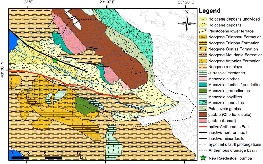
Geologically, the area consists of variously aged units of the Axios Zone and the CTRB (Fig. 2; Makedon et al., Reference Makedon, Chatzigogos and Spandos2009). The Chortiatis Massif, composed of Paleozoic and Mesozoic crystalline and metamorphic rocks, underlies the northern slopes (Kockel and Mollat, Reference Kockel and Mollat1978; Mollat, Reference Mollat1978). Moreover, some deep crustal rocks appear as ophiolithic uplifts of peridotites and dunites. The southern slopes of the Anthemous valley were uplifted (half graben) during the Pleistocene (Syrides, Reference Syrides1990; Zervopoulou et al., Reference Zervopoulou, Chatzipetros, Tsiokos, Syrides and Pavlides2007). The discussed slopes are made up of Neogene sandstones, marls, and conglomerates (Syrides, Reference Syrides1990). Quaternary units (gravels, sands, and clays) occupy the bottom of the valley (Fig. 2). The thickness of the graben infill increases from 30 m in the east to >100 m in the west (Raspini et al., Reference Raspini, Loupasakis, Rozos and Moretti2013).
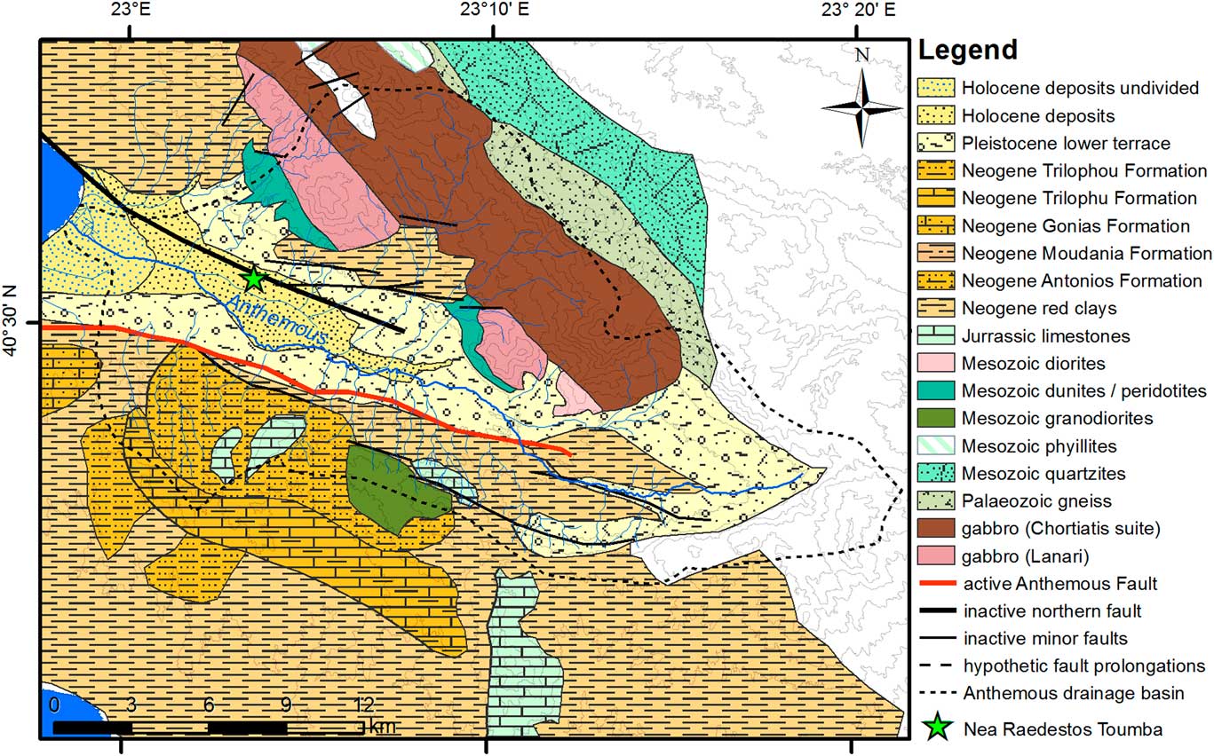
Figure 2. (color online) General view of the geology of the Anthemous valley with major tectonic fault lines indicated. Figure prepared using various data (Kockel and Mollat, Reference Kockel and Mollat1978; Mollat, Reference Mollat1978; Syrides, Reference Syrides1990; Tranos et al., Reference Tranos, Papadimitriou and Kilias2003; Zervopoulou et al., Reference Zervopoulou, Chatzipetros, Tsiokos, Syrides and Pavlides2007). Spatial reference WGS1984 (dd mm ss.ss).
Along the foot of the southern slopes of Anthemous valley runs the Anthemous Fault (Fig. 2), a geologic feature that is thought to continue west under the Thermaic Bay where it meets the Northern Pieria Fault (Mountrakis et al., Reference Mountrakis, Tranos, Papazachos, Thomaidou, Karagianni and Vamvakaris2006). This fault was responsible for major earthquakes in the past (e.g., in 1759; Mountrakis et al., Reference Mountrakis, Tranos, Papazachos, Thomaidou, Karagianni and Vamvakaris2006). Although the Anthemous Fault is the only active fault in the area, several other faults are present along the northern slopes. One of them, the Pilea-Panorama Fault, is located along the foreground of the northern slope of the Anthemous valley (Tranos et al., Reference Tranos, Papadimitriou and Kilias2003; Raspini et al., Reference Raspini, Loupasakis, Rozos and Moretti2013). Because of the presence of the Anthemous Fault in the valley, and the pulling apart of the two major geotectonic zones it marks (Axios Zone and CTRB), the bottom of the valley is continuously subjected to ongoing subsidence and tilting toward the south (Mountrakis et al., Reference Mountrakis, Tranos, Papazachos, Thomaidou, Karagianni and Vamvakaris2006; Zervopoulou et al., Reference Zervopoulou, Chatzipetros, Tsiokos, Syrides and Pavlides2007; Raspini et al., Reference Raspini, Loupasakis, Rozos and Moretti2013). Another effect of this activity is clearly visible along the southern slopes, where several tectonic terraces are clearly visible in the land morphology (Zervopoulou et al., Reference Zervopoulou, Chatzipetros, Tsiokos, Syrides and Pavlides2007).
The western part of the lower basin adjacent to the Thessaloniki Bay is composed of clastic fluvial sediments deposited into a coastal transitional environment (Kockel and Mollat, Reference Kockel and Mollat1978; Mollat, Reference Mollat1978; Vouvalidis et al., Reference Vouvalidis, Syrides and Albanakis2005) (Fig. 2). However, a vast part of the area has been built by fluvial deposits. The effects of aggradation dominate this part of the valley. Contrastingly, the upper basin is erosion dominated, resulting in the creation of numerous hummocks (Niebieszczański, Reference Niebieszczański2016).
The main watercourse of the valley is the Anthemous River, which has a periodic flow characterized by a typical Mediterranean regime with summer dryness (Fig. 1). The most western part of the river (its lower course) has been anthropogenically regulated in recent years by a concrete channel to prevent flooding. The Anthemous River has numerous tributaries, most of which flow along the northern slopes of the valley. The southern tributary streams have, in most cases, been disrupted by tectonic shifts and colluvial fans (Zervopoulou et al., Reference Zervopoulou, Chatzipetros, Tsiokos, Syrides and Pavlides2007).
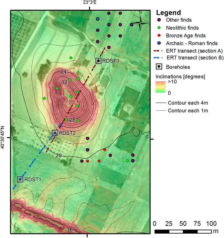
The Nea Raedestos Toumba is located in the central part of the lower basin on the edge of the first terrace (Fig. 3). Presently, the Anthemous River runs ~750 m south of the site; however, there is an inactive channel located 100 m south of the tell (Figs. 3 and 4). This channel connects to the Anthemous River approximately 1 km west of Nea Raedestos.

Figure 3. (color online) Geomorphology of the central part of Anthemous valley lower basin. Figure prepared using various data (Kockel and Mollat, Reference Kockel and Mollat1978; Mollat, Reference Mollat1978; Syrides, Reference Syrides1990; Tranos et al., Reference Tranos, Papadimitriou and Kilias2003; Zervopoulou et al., Reference Zervopoulou, Chatzipetros, Tsiokos, Syrides and Pavlides2007). Spatial reference WGS1984 (dd mm ss.ss).

Figure 4. (color online) Study area of geoarchaeological investigations. Archaeological sampling points were derived from the Anthemous Valley Archaeological Project data. Electrical resistivity tomography (ERT) transect sections A and B correspond to Figure 5. Height isolines are marked in meters above sea level and were derived from RTK (Real Time Kinematics) measurements in the Greek Grid coordinate system. Spatial reference WGS1984 (dd mm ss.ss).
Three different lithologic units can be distinguished within the study site (Fig. 3). The first is located north of the tell and comprises dark brown and red clays with numerous angular rock inclusions. The area to the south of the toumba contains dark clayish sediments similar to those in the modern channel of the Anthemous River. Between these units, a slight morphological threshold is distinguishable and indicates the inclination of the area, which falls toward south. The tell occurs directly along this small threshold. A large number of artifacts, such as ceramic fragments and stone tools, were present on the surface of the tell.
Prior research and archaeological context
Four Neolithic settlements have been found in the Anthemous River valley (Fig. 1), spanning the Middle and Late Neolithic (for northern Greece: ca. 5800/5600–4700/4500 BC; after Andreou et al., Reference Andreou, Fotiadis and Kotsakis2001). Given the relatively small area of the Anthemous River valley compared with other regions, the occurrence of four settlements suggests a dense habitation network. An even more dense settlement structure (13 toumbas; Fig. 1) occurred during the Late Bronze Age (for northern Greece: ca. 1700/1500–1100 BC; after Andreou et al., Reference Andreou, Fotiadis and Kotsakis2001; Figs. 1 and 4), when toumba became prevalent in the area.
Wace (Reference Wace1914) was the first to designate Toumba Nea Raedestos as a prehistoric site. Later, during his stay in Thessaloniki with the French Army, the French archaeologist L. Rey also conducted and published a survey of the toumba (Rey, Reference Rey1921). French (Reference French1967), who visited the site in the 1960s, dated the ceramic material that he collected on the surface to the Late Neolithic and Bronze Age. The survey by Grammenos et al. (Reference Grammenos, Besios and Kotsos1997) adopted French’s observations and dating. During the AVAP survey (Andreou et al., Reference Andreou, Pappa and Czebreszuk2016a), detailed sampling and pottery analyses extended the timing of the occupation of Toumba Nea Raedestos and provided new insights regarding habitation patterns.
Toumba Nea Raedestos is a typical cone-shaped tell with steep sides and is 16 m in height with a base measuring 115 × 80 m (Fig. 3). Illegal digging caused partial damage to the upper plateau of the mound as well as its slopes. The western slope was especially heavily damaged by a large and deep cut into the tell probably related to military activities during World War II.
MATERIALS AND METHODS
Archaeological survey
A detailed archaeological surface survey of Toumba Nea Raedestos was carried out to establish the full chronological span of the site. The survey was conducted in 2013 and followed a bipartite methodology. First, conventional survey methods (counting of visible archaeological finds in tracts) were used to determine the areas of highest density of surface finds. Second, detailed sampling of artifacts was performed at selected points based on the results of the first stage of the survey (Fig. 4). This material was analyzed for chronological and cultural traits, as well as spatial distribution.
Geomorphological and topographic survey
A geomorphological survey was carried out in 2014 to evaluate the surface lithology of the site. A digital elevation model (DEM) of the site (Fig. 4) was also constructed, using the GPS RTK receiver Leica Net Rover. The DEM allowed for the characterization of morphometric parameters of the area, such as slope angle, absolute and relative heights, and local topography by processing and analyzing the DEM in ArcInfo (Fig. 4).
Electrical resistivity tomography
Initial, minimally invasive fieldwork comprised electrical resistivity tomography (ERT) to investigate the lithology and past geomorphic processes at the site. This method has been shown to have great potential in investigating archaeological sites (Tsourlos and Tsokas, Reference Tsourlos and Tsokas2011; Ghilardi et al., Reference Ghilardi, Sanderson, Kinnaird, Bicket, Balossino, Parisot, Hermitte, Guibal and Fleury2015). The ERT survey was performed along a 300 m transect (Fig. 3) that contained the three lithologic zones distinguishable on the surface of the site and its surroundings, including the brown and red clays to the north, the anthropogenic tell, and the alluvial series to the south (Figs. 3 and 4). The visualization of resistivity allowed the selection of suitable locations for core drilling. ERT data were collected using a multichannel resistivity meter Syscal-Pro (IRIS Instruments, France).
Core retrievals and lithology
Vibracoring was employed to preserve the stratigraphy as well as sediment structure and record in contrast to the use of conventional augers (Canti and Meddens, 1998). Three drilled cores (RDST1, RDST2, and RDST3), each measuring 5 cm in diameter, were obtained from the different lithologic areas based on the ERT results (Fig. 4, Table 1). RDST1 was located on dark, clayish sediments interpreted as fluvial. RDST2 was obtained from the southern foot of the toumba (Fig. 4) within the small hummock, which appeared to be the colluvium from the slope of the tell. The location of RDST2 was selected to examine any postdepositional processes that were active at the site, as well as to estimate the position of the base of the toumba in relation to the alluvium. RDST3 was drilled in the area to the north of the tell (Fig. 4), where surficial deposits of brown and red clays dominate.
Table 1. Retrieved cores’ locations and depths.

After extraction, the cores were taken to Aristotle University in Thessaloniki for stratigraphic description. They were then secured in foil and transported to the Faculty of Geographical and Geological Sciences of the Adam Mickiewicz University in Poznań for further analyses. Particle-size analysis was performed by sieving for those fractions with particles >2 mm using conventional meshes of 2500, 3150, 5000, and 6300 μm, whereas finer sediments were analyzed using laser diffraction (Malvern Master Sizer Hydro 2000). Grain-size distribution parameters were calculated using the methods of Folk and Ward (Reference Folk and Ward1957). Finally, samples were subjected to the loss-on-ignition procedure to estimate their organic matter and calcium carbonate content by combustion at 550°C for 4 hours and 950°C for 2 hours, respectively (Dean, Reference Dean1974; Heiri et al., Reference Heiri, Lotter and Lemcke2001).
Absolute and relative chronology
Eleven samples were dated using accelerator mass spectrometry (AMS) radiocarbon dating in the Poznań Radiocarbon Laboratory. Each radiocarbon age was calibrated using OxCal online (Bronk-Ramsey, Reference Bronk-Ramsey1995), using the IntCal13 atmospheric curve for charcoal samples and the Marine13 curve for marine shell fragments (Delta_R 151,40; Table 2) (Reimer et al., Reference Reimer, Bard, Bayliss, Beck, Blackwell, Bronk-Ramsey and Grootes2013). The AMS measurements were also cross validated by the relative dating based on the stylistics of chronologically indicative pottery fragments obtained from the cores, such as Middle and Late Neolithic shards.
Table 2. Radiocarbon dating results from Toumba Nea Raedestos. AMS, accelerator mass spectrometry.

Pollen, non-pollen palynomorphs, and diatom analyses
Pollen and non-pollen palynomorph (NPP) analyses were performed to obtain evidence of vegetation changes (e.g., Moore et al., 1991) on and in the direct vicinity of the site and to detect periods of increased erosion during basin filling (Kołaczek et al., Reference Kołaczek, Zubek, Błaszkowski, Mleczko and Margielewski2013, Reference Kołaczek, Gałka, Apolinarska, Gębica, Superson, Michno and Harmata2017). For pollen and NPP analyses, 37 samples (1 cm3 in volume) from the RDST1 profile were prepared using standard laboratory procedures for palynological analysis (Berglund and Ralska-Jasiewiczowa, Reference Berglund and Ralska-Jasiewiczowa1986). Samples were first treated with a 10% solution of HCl to dissolve carbonates and subsequently heated in 10% KOH to remove humic compounds. Samples were then soaked in 40% HF for a minimum of 6 days (changing HF at least three times) to remove the mineral fraction before acetolysis was applied. Pollen and spores were counted under an upright microscope to a minimum of 200 identifiable pollen grains only because of low pollen concentrations and a high number of unidentified and damaged pollen grains. Pollen grains were identified with the assistance of atlases and keys (Moore et al., 1991; Beug, Reference Beug2004). The NPPs were identified with the use of available literature (e.g., van Geel, Reference van Geel1978; Miola, Reference Miola2012). The site reflects very local (site-scale) patterns of vegetation; hence, the percentages of pollen grains were calculated on the basis of the ratio of an individual taxon to the total pollen sum (TPS). In our study, the TPS is the sum of all pollen grains excluding spores and NPPs. Percentages of spores and NPPs were calculated separately according to the ratio of spore or NPP taxon number to TPS enlarged by the NPP type or spore number.
Thirty-two diatom analyses were carried out to assess the environments recorded in the cores. The analyses were conducted using the methods of Battarbee (Reference Battarbee1986). Samples were treated in 10% HCl to remove calcium carbonate and washed several times in distilled water. Afterward, the samples were boiled in 30% H2O2 to oxidize the organic matter. Permanent microscope slides were mounted in Naphrax. The diatom identifications were performed using a Nikon Eclipse E-200 light microscope. The diatoms were identified according to Krammer and Lange-Bertalot (Reference Krammer and Lange-Bertalot1986, Reference Krammer and Lange-Bertalot1988, Reference Krammer and Lange-Bertalot1991a, Reference Krammer and Lange-Bertalot1991b), Denys (Reference Denys1991), Lange-Bertalot (Reference Lange-Bertalot1999), Lange-Bertalot and Genkal (Reference Lange-Bertalot and Genkal1999), Krammer (Reference Krammer2002), Lange-Bertalot et al. (Reference Lange-Bertalot, Witkowski, Bogaczewicz-Adamczak and Zgrundo2003), Hoffmann et al. (Reference Hoffmann, Werum and Lange-Bertalot2011), and Lange-Bertalot (Reference Lange-Bertalot2011). Because of the very low concentration of diatoms, the number of valves counted in the sample varied from 2 to 266—that is, lower than recommended for the purpose of routine analysis (300–600; Battarbee, Reference Battarbee1986; Battarbee et al., Reference Battarbee, Jones, Flower, Cameron, Bennion, Carvalho and Juggins2001).
RESULTS
ERT results
The interpolated ERT profile differentiated the underground structure of sediments forming the Toumba Nea Raedestos and its surroundings (Figs. 4 and 5). The transect profiles spanned >300 m horizontally and 45 m vertically, allowing the definition of four principal units. First was the tell structure, visible also in the land relief. The tell comprises relatively low-resistivity sediments (7–9 Ω/m) that differ significantly from the background layers. Particularly important are the layers situated along the tell foreground, likely the colluvium accumulation from the erosion of the slope of the toumba. The ERT profile of the site shows a larger amount of accumulated debris on the northern side of the tell than its southern side (Fig. 5). This asymmetry was also seen in the morphological inclination of these two slopes, suggesting that the northern slope was subjected to more intense denudation.
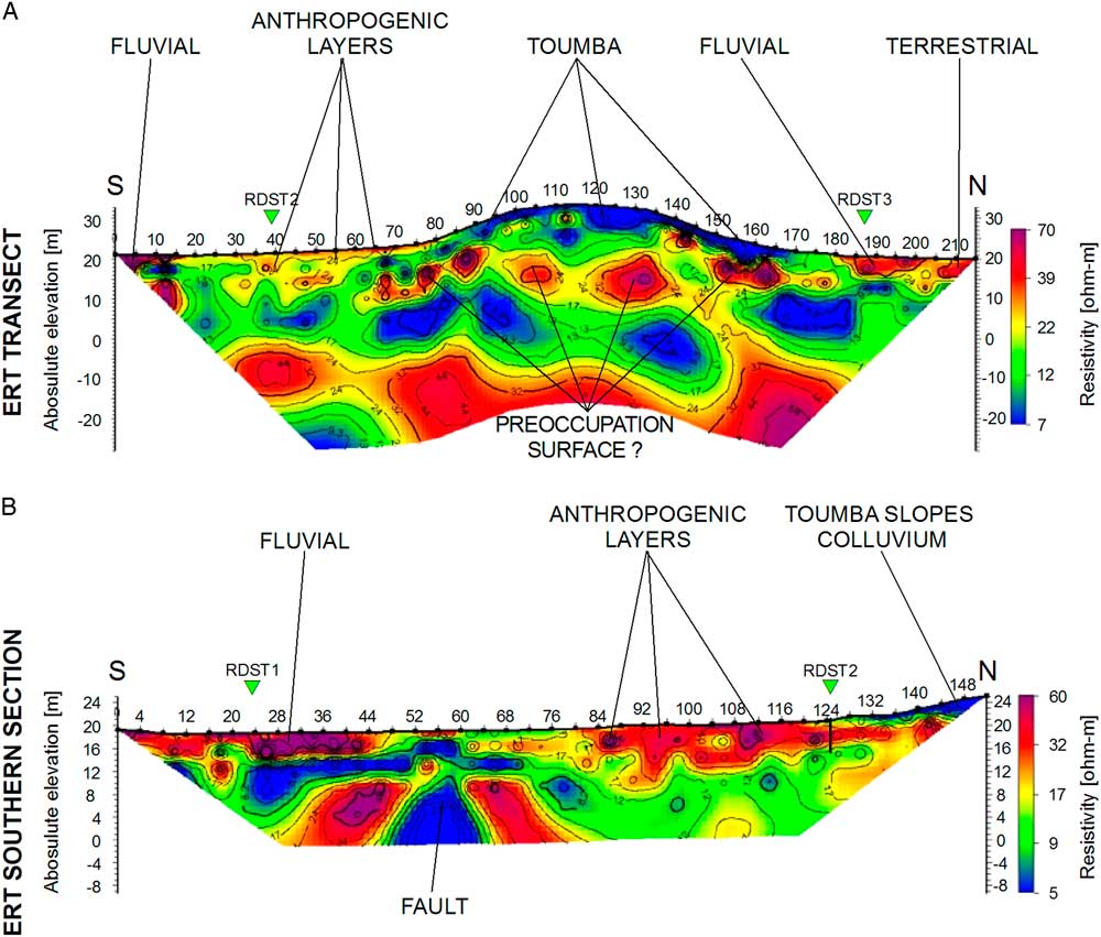
Figure 5. (color online) Electrical resistivity tomography (ERT) in Nea Raedestos—Sections A and B according to Figure 4, respectively.
A horizontal feature was identified directly beneath the tell that continued along most of the transect with an average elevation of 15 m asl (Fig. 5, section A). This structure is geoelectrically homogeneous (22–39 Ω/m) and most probably represents the surface on which the site was established. ERT visualization revealed an anomaly of significantly high resistivity properties (40–70 Ω/m) in the very northernmost part of the transect, above the horizontal structure.
The southern section of the ERT profile is, however, the most rich in terms of lithologic differentiation. A higher-resolution model of this section was carried out to understand its complexity (Fig. 4, section B). The low-resistivity structure (approximately 5 Ω/m) in the northern part of this section represents the colluvium layers of the toumba foreground. A feature of significantly high resistivity properties (30–60 Ω/m) occurs to the south of this colluvium and appears to be a cross section of a channel similar to the structure recorded north of the tell. Another similar feature is located in the southern part of the ERT’s southern section (Fig. 5, section B) and is characterized by very high resistivity values (approaching 55–60 Ω/m); it is possibly a paleochannel. A vertical discontinuity of layers lies between these structures at an elevation of 12 m asl and probably represents a minor tectonic displacement parallel to the main Anthemous Fault line. Therefore, it could be possible that the two channels evident in the ERT show the migration stages of the Anthemous River that occurred because of the subsidence of the valley floor and creation of tectonic terraces observed in the discussed valley (Zervopoulou et al., Reference Zervopoulou, Chatzipetros, Tsiokos, Syrides and Pavlides2007).
Core RDST1
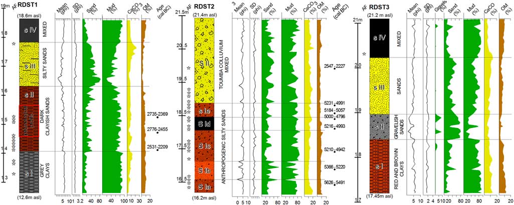
The stratigraphy of core RDST1 reflected four lithologic sections (Table 1): (1) gray clays from 6 to 4.5 meters below ground level (m bgl) (12.6–14.1 m asl); (2) dark clayish sands from 4.5 to 2.5 m bgl (14.1–16.1 m asl); (3) silty sands from 2.5 to 0.8 m bgl (16.1–17.8 m asl); and (4) agricultural mixed horizon from 0.8 to 0 m bgl (17.8–18.6 m asl) (Fig. 6).
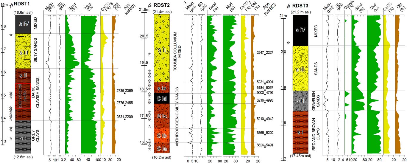
Figure 6. (color online) Stratigraphy and sedimentology of the cores obtained from Nea Raedestos. “AF,” archaeological find; “CaCO3 (%),” calcium carbonate contamination in percentage; “Gravels (%),” percentage of gravel fraction; “Mean (phi),” mean grain size in phi scale; “Mud (%),” percentage of silt and clay fraction; “OM (%),” organic matter contamination in percentage; “Sands (%),” percentage of sand fraction; “SD (phi),” standard deviation (sorting) in phi scale. m asl, meters above sea level.
RDST1: section I
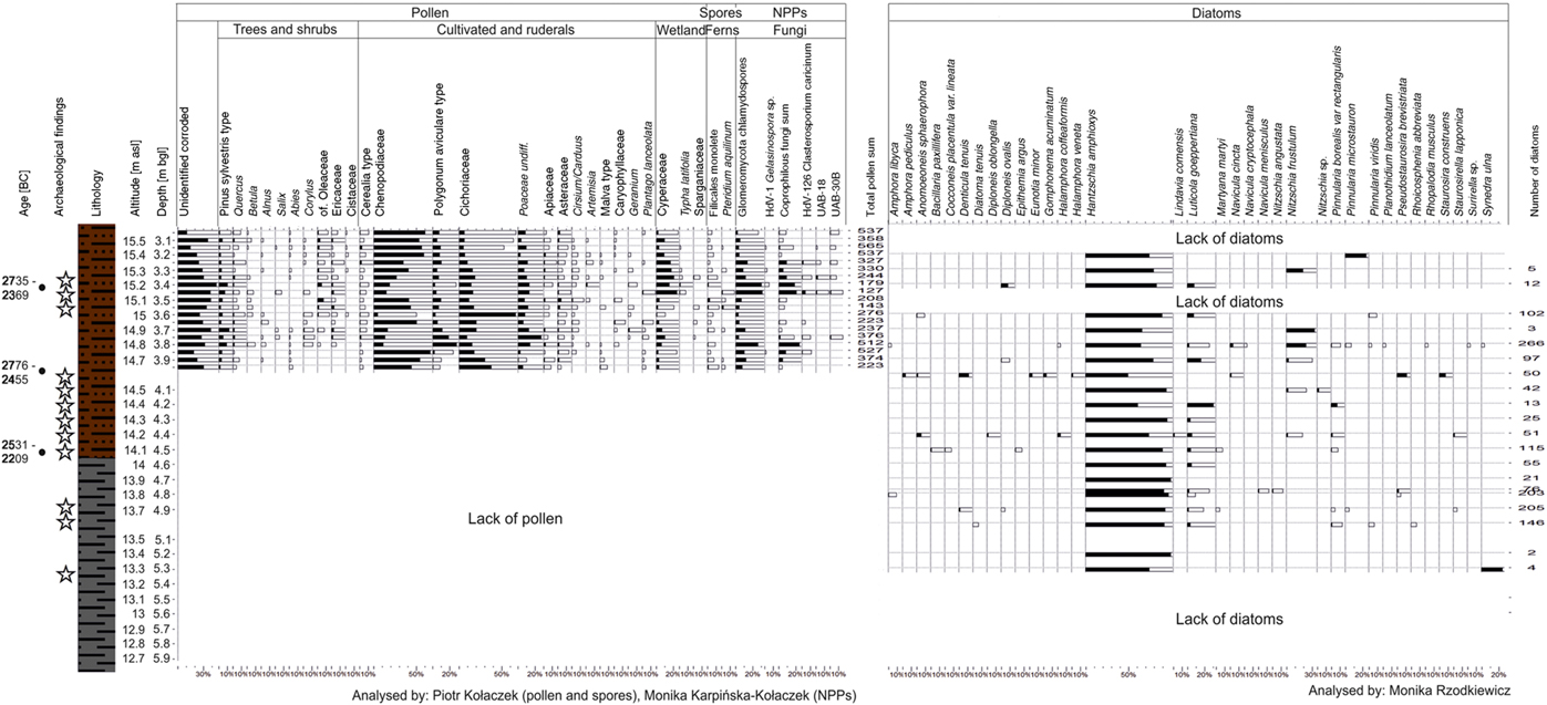
The lowest section, from 12.6 to 14.1 m asl, is characterized by the presence of gray clays and the rare archaeological artifacts or organic remains. The brightness of the colors indicates more mineral content as well as decreased sand content, suggesting more stable sedimentation. The laminations were also recorded, providing evidence for the presence of a water body. At 13.55 m asl, a distinctive sharp-edged ceramic fragment was recorded and determined to be a piece of pottery (Fig. 7A) made using the red-slipped technique—a characteristic type of vessel production affiliated with the Middle Neolithic period in the region (~5800/5600–5400/5300 BC; Andreou et al., Reference Andreou, Fotiadis and Kotsakis2001). The concentration of diatoms significantly increased from 13.6 m asl to the surface at 18.6 m asl (Fig. 8), dominated by Hantzschia amphioxys (92–100%). This species prefers freshwater habitats that are only periodically inundated (Hoffmann et al., Reference Hoffmann, Werum and Lange-Bertalot2011), thus failing to indicate the presence of a permanent water body in the area of RDST1. However, sporadic appearances of Luticola goeppertiana may support the presence of some fluvial events based on the tendency of this species to occur in running water (Hoffmann et al., Reference Hoffmann, Werum and Lange-Bertalot2011). Slight admixture of sands into the clays also suggests water influxes into this water body.
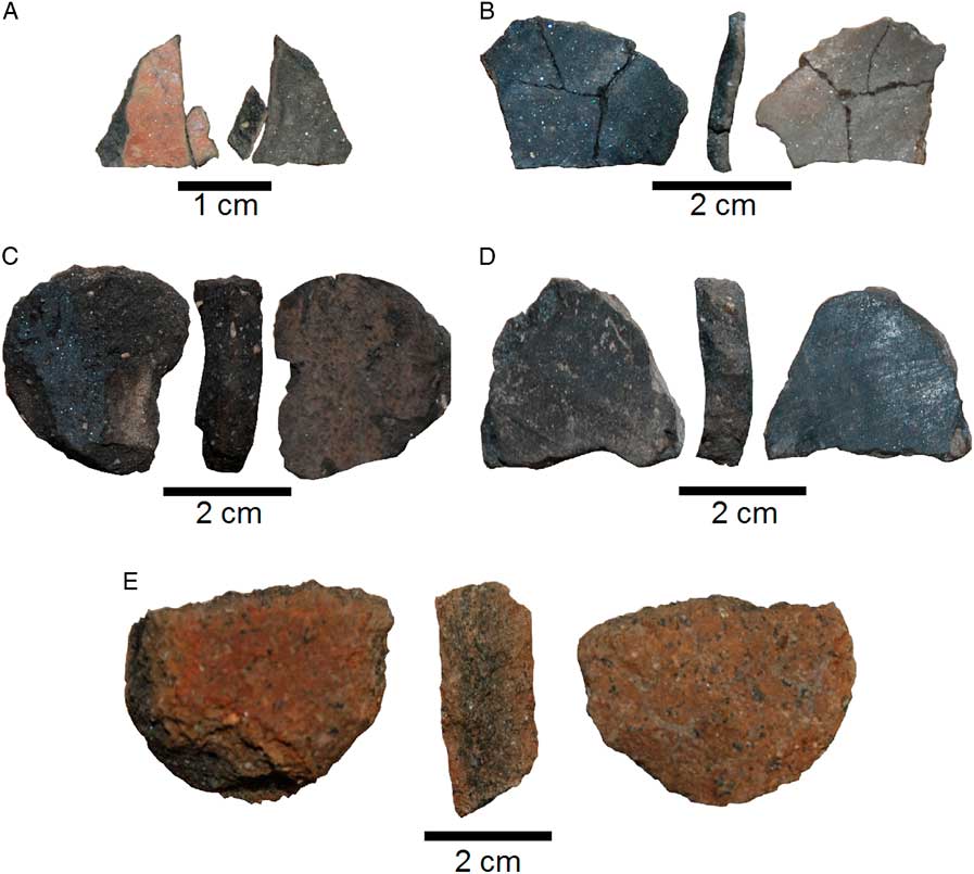
Figure 7. (color online) Pottery fragments retrieved from cores. (A) Core RDST1, depth 5.05 meters below ground level (m bgl), red-slipped Middle Neolithic pottery fragment. (B) Core RDST2, depth 3.47 m bgl, black-burnished Late Neolithic pottery fragment (thin). (C and D) Core RDST2, respectively 3.18 and 3.33 m bgl, black-burnished Late Neolithic pottery fragments (coarse—probably bottom part of a vessel). (E) RDST2, 1.35 m bgl, coarse Bronze Age pottery fragment (container vessel?).

Figure 8. (color online) Pollen, non-pollen palynomorph (NPP), and diatom percentage diagrams of RDST1 core from Nea Raedestos. Stars indicate archaeological finds. Diagrams illustrating the paleobotanical data were drawn using POLPAL software (Nalepka and Walanus, Reference Nalepka and Walanus2003). m asl, meters above sea level; m bgl, meters below ground level.
RDST1: section II
In this section of the core (14.1–16.1 m asl), clays and silts were dominant, which reflects a relatively calm sedimentary environment. Dark-brown sandy clays were characterized by a higher share of the sand fraction, thus indicating influxes of water flows into the water body. This section contained fragments of marine shells of Cerastoderma glaucum, most probably deposited anthropogenically in the water body as they occurred in association with archaeological artifacts. Section II was dated to the Early Bronze Age, between ~2800 and 2200 BC, by AMS radiocarbon dating performed on the marine shells (Table 2, Fig. 6).
The concentration of sporomorphs in the sediments was sufficient to carry out palynological analyses between 14.6 and 15.6 m asl (Fig. 8). However, most of the sporomorphs were strongly damaged, which suggests temporary desiccation of the water body and/or the erosion of pollen deposited in the topmost layers of the water body (cf. Havinga, Reference Havinga1971; Campbell, Reference Campbell1991; Campbell and Campbell, Reference Campbell and Campbell1994). The water body was probably small and would have maintained only a very local record of vegetation development. The dominant pollen grains originated from ruderal (related to anthropogenically changed habitats) species, such as Chenopodiaceae, Polygonum aviculare, Cichoriaceae, Plantago lanceolata, and Artemisia (cf. Behre, Reference Behre1981; Gaillard, Reference Gaillard2013). The relatively close proximity of cultivated fields was marked by the stable presence of Cerealia type pollen. The open area in the direct vicinity of the water body and strong pollen corrosion probably caused the underrepresentation of arboreal taxa. Quercus and Pinus sylvestris type were the most common AP (arboreal pollen) representatives; these trees were likely the dominant forest species located in the valley, though at higher elevations or in adjacent areas. Shrub communities were indicated by cf. Oleaceae, Ericaceae, and Cistaceae specimens. The damp shores of the water body were overgrown by Cyperaceae, Poaceae, and Typha latifolia. The presence of the former taxon was corroborated by the co-occurrence of hypopodia of the parasitic fungus Clasterosporium caricinum (HdV-126) (van Geel, Reference van Geel1978). The water body might have desiccated periodically, and the resulting depression could have been colonized by herbs, explaining the appearance of Glomeromycota fungi, symbiotic root organisms (Kołaczek et al., Reference Kołaczek, Zubek, Błaszkowski, Mleczko and Margielewski2013). Their percentages revealed two distinct peaks, which, apart from their in situ occurrence, might have been redeposited from topsoil layers in the river catchment during fluvial episodes (cf. Kołaczek et al., Reference Kołaczek, Gałka, Apolinarska, Gębica, Superson, Michno and Harmata2017). Moreover, the presence of fungal NPP UAB-30B indicates soil erosion as the agent contributing to sediment accumulation in the water body in the layer between 15.1 and 15.6 m asl (Revelles et al., Reference Revelles, Burjachs and van Geel2016). The stable presence of coprophilous fungi (represented by Sordaria sp., Coniochaeta lignaria, Sporormiella sp., and Podospora sp.) indicates frequent visits of herbivores (possibly livestock) to the water body. However, their maximum percentage maxima were associated with that of Glomeromycota, so fluvial events might also have been responsible for increases in coprophilous fungi abundance (cf. Kołaczek et al., Reference Kołaczek, Gałka, Apolinarska, Gębica, Superson, Michno and Harmata2017).
The diatom flora was dominated by Hantzschia amphioxys, suggesting desiccation of the water body; however, its relative abundance was lower than in the gray clays of section I (50–96%). Luticola goeppertiana (0–31%) was more frequent than in section I, which may indicate an increase in fluvial activity (Hoffmann et al., Reference Hoffmann, Werum and Lange-Bertalot2011). At 14.8 and 15.3 m asl, a substantial increase (though on a very low number of diatoms) in Nitzschia frustulum (up to 23%) was recorded. N. frustulum is found in natural saline inland waters and sea shoreline habitats (Hoffmann et al., Reference Hoffmann, Werum and Lange-Bertalot2011). Importantly, the maximum occurrence of the former was concurrent with those of Glomeromycota spores and coprophilous fungi, which suggests the possibility of inflow of saline waters during fluvial events (cf. Kołaczek et al., Reference Kołaczek, Gałka, Apolinarska, Gębica, Superson, Michno and Harmata2017). On the other hand, apart from N. frustulum there were no other abundant marine plankton organisms, which implies a lack of marine water inflow. Moreover, the presence of brackish groundwater in other parts of the Anthemous River valley stands against the interpretation including marine intrusions (Papadopoulos et al., Reference Papadopoulos, Tsourlos, Karmis, Vargemezis and Tsokas2004).
RDST1: section III
The layers between 16.1 and 17.8 m asl consisted of sands. The grain-size distribution parameters (standard deviation ~1.5 on phi scale) suggest that this material was deposited in a fluvial, low-energy current environment. Nearly 80% of the samples were sands with a small admixture of silts and clays. This layer did not contain any archaeological remains or organic material suitable for chronological estimation.
RDST1: section IV
Finally, the topmost 0.8 m (between 17.8 and 18.6 m asl) represented a layer of agricultural disturbance such as plants roots, waste, and the remains of fertilizers. Hence, it was excluded from the paleogeographic reconstruction.
Core RDST2
The core RDST2 was drilled in the southern foot of the Toumba Nea Raedestos (Table 1, Fig. 4) on a small hummock formed by the accumulation of colluvium from the southern slope of the tell. Almost the entire stratigraphic sequence documented in the core reflects archaeological deposition related to the prehistoric settlement (Fig. 6) as well as a record of onsite postdepositional processes. Specifically, the core contained two main lithologic sections: (1) silty sands with artifacts from 5.2 to 2.5 m bgl (16.23–18.93 m asl) and (2) mixed sediments characterized by the dominance of sands and silts, again with artifacts from 2.5 to 0 m bgl (18.93–21.43 m asl).
RDST2: section I
From 16.23 up to 18.93 m asl, sediments with an abundance of pottery, charcoal particles, stone tools, and other finds were recorded. The latter group of finds included ecofacts such as marine shells, which would not normally be found in a terrestrial environment. This section can be further separated into minor units differentiated by abundance of artifacts and varying sedimentologic indicators. These subsections are as follows: (Ia) silty sands with artifacts from 16.23 to 16.63 m asl; (Ib) silty sands with a scarce occurrence of finds from 16.63 to 17.43 m asl; (Ic) silty sands with numerous artifacts from 17.43 to 18.03 m asl; (Id) dark organic sediments with charcoals and finds from 18.03 to 18.43 m asl; and (Ie) silty sands with artifacts from 18.43 to 19.03 m asl.
RDST2: subsection Ia
The first subsection, 16.23 to 16.63 m asl, is composed of silty sands with an abundance of pottery, charcoal particles, and one shell fragment. The shell fragment was AMS dated to 5626–5491 BC (Table 2, Fig. 6). In the upper levels, a charcoal fragment provided a slightly younger age of 5366–5220 BC (Table 2, Fig. 6). Both ages correspond to the Middle Neolithic and beginning of the Late Neolithic period in the area (cf. Andreou et al., Reference Andreou, Fotiadis and Kotsakis2001).
RDST2: subsection Ib
The subsection between 16.63 and 17.43 m asl was characterized by relatively scarce occurrences of archaeological remains with a corresponding decrease in the proportion of both calcium carbonate and organic matter (Fig. 6). Moreover, the fluctuation of the sand fraction over a range with an amplitude of 60% (from 20% up to 80% of the samples) in this subsection indicates an unstable sedimentary environment.
RDST2: subsection Ic
The layer with the greatest number of artifact inclusions—including pottery fragments, stone tools, and organic remains such as charcoal particles and marine shells—was encountered from 17.43 to 18.03 m asl. Radiocarbon AMS dating of a Cerastoderma glaucum fragment at the depth of 17.46 m asl produced an age of 5210–4942 BC, placing the deposition of this subsection in the Late Neolithic.
RDST2: subsection Id
The next subsection of the profile, covering between 18.03 and 18.43 m asl, consisted of dark organic sediments with numerous charcoal fragments indicative of fire activity. Two charcoal fragments (depths 18.28 and 18.03 m bgl; Table 2) were radiocarbon dated to 5194–4910 BC. Three diagnostic pottery shards, one fine shard produced using the black-burnished technique and two coarse pieces of the same type representing the base of a vessel/vessels, were found included among the archaeological artifacts in this subsection (Fig. 7B–D). The black-burnished style of pottery production was characteristic in the region during the Late Neolithic (~5400/5300–4700/4500 BC), thus corroborating the radiocarbon estimations.
RDST2: subsection Ie
Above the burnt layer of subsection Id, there was a continuation of settlement stratification up to 19.03 m asl. Two charcoal fragments from the depths 19.01 and 18.61 m asl were AMS dated to the Late Neolithic age (respectively 5291–5247 BC and 5302–5191 BC; Table 2). Thus, the chronostratigraphy suggests the continuation of human habitation during the Late Neolithic after the fire event recorded in subsection Id.
RDST2: section II
A layer of highly mixed sediments with a large proportion of artifacts occurred from 18.93 m asl to the surface at 21.43 m asl (Fig. 6). This was interpreted as colluvial layers from the tell based on the poor sorting of the sediments (Dreibrodt and Bork, Reference Dreibrodt and Bork2005) and the anthropogenic remains. This subsection of the core contained relatively coarse fragments of pottery, probably derived from Bronze Age vessels (Fig. 7E).
Core RDST3
The core RDST3 was obtained from the northernmost section of the ERT profile (Table 1, Fig. 4) where the brown and red clay series dominate the surface. The lithology of the core represents four sections (Fig. 6)—namely, (1) red and brown clays with manganese inclusions from 17.43 to 18.38 m asl, (2) gravels and coarse sands from 18.38 to 18.88 m asl, (3) yellowish sands from 18.88 to 20.38 m asl, and (4) mixed organic sediments from an agricultural horizon from 20.38 to 21.18 m asl.
RDST3: section I
Heavy clayish terrestrial sediments of brown and reddish colors were encountered from the bottom of the core at 17.43 m asl to 18.38 asl. The fraction of silts and clays was constant and reached nearly 90%. Additionally, numerous blackish inclusions from manganese oxides occurred within the substrate. Based on prior studies in the region, these kinds of sediments are characteristic of pre-Holocene terrestrial deposits (Syrides et al., Reference Syrides, Albanakis, Vouvalidis, Pilali-Papasteriou, Papaefthimiou-Papanthimou, Ghilardi, Fouache, Paraschou and Psomiadis2009). According to the surface geologic map (Kockel and Mollat, Reference Kockel and Mollat1978; Mollat, Reference Mollat1978), these units likely represent the Pleistocene erosional terrace. In the upper part of this layer, several inclusions of weathered, reddish pottery fragments indicated that the red clays could have served as the surface of human occupation in the past.
RDST3: section II
Gravels and coarse sands occurred between 18.38 and 18.88 m asl in the form of inclusions several centimeters thick, reflecting high-energy discharges. These were divided by a layer of fine sands that suggest interspersed lower-energy currents in the fluvial environment.
RDST3: section III
Between 18.88 and 20.38 m asl, there was a layer of fine sands with a considerable admixture of silts and clays from 45 to 80% and a total lack of gravel fraction. The presence of such sediments could indicate overbank sedimentation or low-energy fluvial currents.
RDST3: section IV
The uppermost section of the core (20.38 and 21.18 m asl) was composed of clays with considerable organic matter share (above 10%). The presence of roots, waste, and the remains of fertilizers suggested that this layer corresponds to the agriculturally disturbed horizon.
A single chert flake (at 20.88 m asl), probably part of a scratching tool, was encountered in the uppermost part of this section. However, this layer corresponds to agricultural disturbance, and, therefore, the artifact was probably redeposited.
DISCUSSION
Anthropogenic versus natural factors
The area to the south of the tell witnessed relatively stable sedimentation within a small water body, likely a cutoff channel that remained functional during the Early Bronze Age (~3300–2300 BC) (Fig. 9). According to the stratigraphy of the RDST1 profile, this water body disappeared directly after or during a fluvial event. The relative dating of pottery from the lower layers suggests that the body of water also existed during the Middle Neolithic (~5800/5600–5400/5300 BC). The only section of the profile in which pollen grains were preserved corresponded to the Bronze Age. The palynological and diatom data show that the reconstructed pond was periodically dry but occasionally refilled by influxes of fresh water. These influxes are visible in the sedimentologic analysis where coarser material is periodically present along the higher sections of the water body. Furthermore, the presence of numerous artifacts within these layers indicates that this water body was used by the Early Bronze Age societies that occupied the Toumba Nea Raedestos. This is also confirmed by the occurrence of coprophilous fungi spores and cereals in the analyzed sediments. There is no evidence, either from artifacts or radiocarbon dating, that the water body existed later than the Early Bronze Age (Fig. 9).
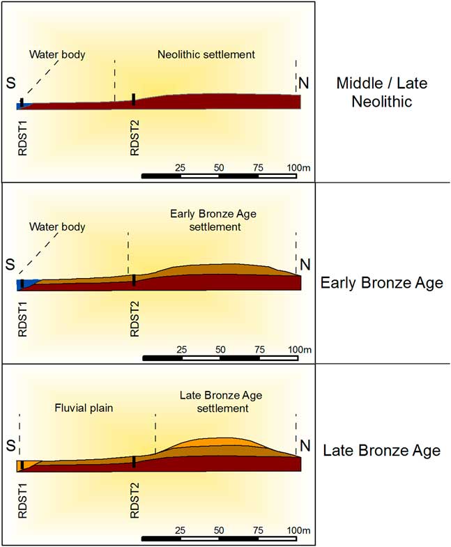
Figure 9. (color online) Three stages of landscape evolution in Nea Raedestos based on the RDST1 and RDST2 stratigraphy and radiocarbon dating.
The area to the north of the Toumba Nea Raedestos was characterized in the past by a succession of fluvial events over terrestrial deposits of red clays. The latter sediments, composed of units accumulated almost certainly before the Holocene, were covered by overbank sedimentation and channel deposits. At least two sequences of active channel flows were evident in core RDST3, separated by less energetic fluvial currents, which were probably present during floods. Fluvial activity must have occurred during the Holocene because of the inclusion of weathered fragments of pottery within the upper part of the red clay series. The fluvial sands and gravels indicating river currents did not contain any datable material such as distinctive artifacts or organics; therefore, their age could be restricted, at most, to the Holocene.
Archaeologically, the most informative core was RDST2, situated directly next to the tell, as it provided information about the site’s stratigraphy and chronology. Below the uppermost part of the core, which comprised colluvial layers that originated from the slopes of the tell, anthropogenic sediments related to the settlement continued for another 3 m to the end of core. The latter reflected the Middle and Late Neolithic phases of the site’s occupation. During the Late Neolithic, there was a fire event, represented by a burnt layer abundant in ceramics and charcoals. However, this event did not mark the end of human occupation, as the prehistoric settlement record continued above this feature. A significant decrease in artifact occurrence and some grain-size parameters in the lower section of the core suggest a possible hiatus or less-intensive habitation activity in this area at that time.
Based on the archaeological record of Neolithic remains in the Anthemous River valley, it is possible to interpret the occupation layers in RDST2 as representative of a multilayered settlement similar to the nearby contemporary site recorded in Vassilika C–Kyparissi, in contrast to the nearby flat/extended sites of Thermi and Galatista (Fig. 1) (Grammenos, Reference Grammenos1991; Andreou et al., Reference Andreou, Pappa and Czebreszuk2016a; Pappa et al., Reference Pappa, Nanoglou and Efthymiadou2016, Reference Pappa, Nanoglou and Efthymiadou2017, Reference Pappa, Νanoglou, Efthimiadou and Asimakopoulosin press). Further confirmation of this hypothesis requires a denser network of coring in order to examine with accuracy the spatial extent of Neolithic remains. Nonetheless, it is still possible to assume, based on the findings of RDST1 and 2, and the distribution of the Neolithic pottery, that the Neolithic tell of Raedestos definitely extended beyond the limits of the later Bronze Age site. It must have been much smaller in size than the two flat/extended settlements mentioned previously, which range between 8 and 10 ha, but was also distinctively different from its Bronze Age successor. Excavated Late Bronze Age settlement mounds in central Macedonia often contained a series of strong retaining terraces on the edge of sites and the mudbrick walls of dwellings were left standing to a considerable height so that the house walls of the next phase were founded directly on top of them. The latter features contributed to the quick increase in the height of the tell settlements in addition to the steep slopes of central Macedonian tells (Andreou and Kotsakis, Reference Andreou and Kotsakis1994).
The Neolithic settlement was almost certainly located at the edge of the terrace, near the water body. During the Neolithic, the water body was characterized by stable sedimentation indicated by some discernible laminations in core RDST1. However, sedimentologic parameters and paleoenvironmental data indicate that, during the Early Bronze Age, its appearance changed. The radiocarbon dating defines the timing of the last stage of the water body’s evolution to the Early Bronze Age. During this time, the natural environment at the site was transformed from its original state. The vegetation around Nea Raedestos was dominated by ruderal communities, whereas the pond was overgrown by swampy plants. Probably by the later Bronze Age (~2300/2200–1100 BC), the human settlement had lost access to this water body as it was covered with alluvium.
Tectonic activity at Toumba Nea Raedestos was evident in the vertical dislocation of layers recorded in the ERT visualization. This feature separates the prehistoric settlement from the water body sediments. The tectonic activity in the area could have had an influence on the development of the local hydrography. This argument is reinforced by the general tectonic context of this area and its consequence with the subsidence of the valley floor with simultaneous tilting toward the south (Raspini et al., Reference Raspini, Loupasakis, Rozos and Moretti2013). Therefore, it is likely that there was a migration of the lowest drainage lines because of tectonic shifts. During the Neolithic and Early Bronze Age, the main course of the Anthemous River was probably located closer to the site than its present location ~1 km to the south.
According to our reconstructions, the relatively small area surrounding the Toumba Nea Raedestos bears signs of major landscape changes and presents a diversity of recorded sedimentary environments. The past landscape was characterized by highly dynamic transformations attributable to both natural and anthropogenic processes. The former mainly involved river activity, which was documented both to the north and south of the tell. Fluvial processes were reflected in the presence of stable sedimentation, high-energy currents, and overbank deposition (floods). Natural factors may also have included tectonic activity, which is observed as a vertical displacement of layers in the southern part of the area.
The second group of factors included the anthropogenic processes related to the development of the human settlements that lasted from at least the Middle Neolithic through to the end of the Bronze Age and beginning of the Early Iron Age. The impact of this human occupation on the environment can be seen in the palynological record of core RDST1. The reconstruction of the vegetation history of the immediate surroundings of Nea Raedestos revealed the ruderal character of this area during the Early Bronze Age. Presently, a large portion of the Anthemous River valley is occupied by heavily transformed vegetation attributable to agriculture. During the Early Bronze Age, around 2500 BC, the first significant deforestation is evident in palynological profiles from the region (e.g., Gerasimidis et al., Reference Gerasimidis, Panajiotidis, Fotiadis and Korakis2009). Therefore, the small number of arboreal species and evidence for the dominance of ruderal plants in RDST1 could be a local reflection of the general deforestation in the region.
Within the wider context of Toumba Nea Raedestos, the remains of later human activity, such as a Roman period site located several hundred meters to the north, are also known. To summarize, the archaeological stratigraphy at the Toumba Nea Raedestos measures at least 22 m vertically comprising 3 m of Neolithic and 19 m of Bronze Age deposits. This evidence of ongoing inhabitation of the same location for more than 4000 yr suggests a high degree of human impact on the environment as well.
Regional context of landscape changes
The results of the geoarchaeological investigations and paleoenvironmental reconstruction at Toumba Nea Raedestos can be considered within the wider regional context both archaeologically and paleogeographically. First, a correlation of river aggradation processes in Nea Raedestos at the onset of the third millennium BC with adjacent regions should be considered. These processes are one of the principal factors of landscape changes in the valleys and plain areas of northern Greece during the Holocene. An example of such an influence is the case of the Neolithic settlement in Nea Nikomedia, located in the southern part of the Thessaloniki Plain. During its occupation, the site was located near an extensive lake. The water body was transformed into swamps around 6000 BC, probably forcing the prehistoric population to abandon the settlement. Presently, the archaeological site is located several kilometers inland as a result of sea regression and landscape changes attributable to fluvial activity (Bintliff, Reference Bintliff1976; Ghilardi et al., Reference Ghilardi, Psomiadis, Cordier, Delanghe-Sabatier, Demory, Hamidi, Paraschou, Dotsika and Fouache2012). The onset of intensified aggradation caused by agriculture can also be traced in eastern Macedonia, where the change in land cultivation during the Late Bronze Age resulted in increased soil erosion and silting of the streams (Lespez, Reference Lespez2003). A later example of landscape changes stimulated by river progradation is Pella, the fourth century BC capital of the Macedonian kingdom, located in the Thessaloniki Plain. During its peak, this city functioned as a seaport, because lake systems allowed ships to sail toward the open waters of the Aegean Sea. Currently, Pella is located about 40 km inland (Ghilardi et al., Reference Ghilardi, Fouache, Queyrel, Syrides, Vouvalidis, Kunesch, Styllas and Stiros2008a, Reference Ghilardi, Kunesch, Styllas and Fouache2008b) demonstrating the scale of transformation attributable to river progradation.
A vast part of the Anthemous valley—namely, the lower basin (Vassilika basin)—is dominated by alluvial sediments (Niebieszczański, Reference Niebieszczański2016). The results of the lithologic examination of the Bronze Age tell in Loutra Thermis revealed it to be embedded ~3 m deep in alluvial sediments. Within these, several channel features in the form of gravel inclusions were identified, which suggest the presence of varying development of hydrographic systems in the past. In the same area, trenches for the installation of a water pipe parallel to the Anthemous River revealed the stratigraphy of the flood sediments (Niebieszczański, Reference Niebieszczański2016). These also included gravels and coarse sand inclusions similar to those found in the vicinity of the Nea Raedestos tell. The depth of these trenches exceeded 4 m, and it was not possible to reach the base level of the alluvial units. Therefore, the great thickness of flood sediments in this area should be taken into account in the evaluation of the archaeological data and the reconstruction of the patterns of past human activity in the valley.
Toumba Nea Raedestos is situated on the edge of a terrace, nearby which at a lower elevation a water body existed during the Neolithic and Early Bronze Age. The radiocarbon dating shows that its termination was likely related to flood sedimentation directly after or during the later phases of the Early Bronze Age. These data can be compared with those from the Thessaloniki Plain, where coastline migration attributable to delta progradation has been identified in numerous studies (Bottema, Reference Bottema1974; Vouvalidis et al., Reference Vouvalidis, Syrides and Albanakis2005; Ghilardi et al., Reference Ghilardi, Fouache, Queyrel, Syrides, Vouvalidis, Kunesch, Styllas and Stiros2008a, Reference Ghilardi, Kunesch, Styllas and Fouache2008b, Reference Ghilardi, Genc, Syrides, Bloemendal, Psomiadis, Paraschou, Kunesch and Fouache2010, Reference Ghilardi, Psomiadis, Cordier, Delanghe-Sabatier, Demory, Hamidi, Paraschou, Dotsika and Fouache2012; Syrides et al., Reference Syrides, Albanakis, Vouvalidis, Pilali-Papasteriou, Papaefthimiou-Papanthimou, Ghilardi, Fouache, Paraschou and Psomiadis2009; Psomiadis et al., Reference Psomiadis, Ghilardi, Demory, Delanghe-Sabatier, Bloemendal and Yiu2013). In light of these studies, the maximum extent of the Holocene sea transgression occurred around 3200 BC in the northern part of the Thessaloniki Plain (Archontiko: Syrides et al., Reference Syrides, Albanakis, Vouvalidis, Pilali-Papasteriou, Papaefthimiou-Papanthimou, Ghilardi, Fouache, Paraschou and Psomiadis2009), while the central part witnessed a maximum marine intrusion at the beginning of the third millennium BC (Fouache et al., Reference Fouache, Ghilardi, Vouvalidis, Syrides, Styllas, Kunesch and Stiros2008; Ghilardi et al., Reference Ghilardi, Psomiadis, Cordier, Delanghe-Sabatier, Demory, Hamidi, Paraschou, Dotsika and Fouache2012). Major sea level rise was observed in the Thessaloniki Plain until ~3000 BC. Since ~3000 BC, increased discharges and deltaic progradation of rivers began, which caused the coastline to retreat toward the east because of the formation of fluvial levees and fans (Ghilardi et al., Reference Ghilardi, Fouache, Queyrel, Syrides, Vouvalidis, Kunesch, Styllas and Stiros2008a). The chronostratigraphic data from this period document an increased transportation and accumulation rate of the Axios, Loudias, and Aliakmon Rivers (Ghilardi et al., Reference Ghilardi, Kunesch, Styllas and Fouache2008b). Thus, major alluviation processes started in this area around the first half of the third millennium BC. This period corresponds with the increased discharges of fresh water into the water body at Nea Raedestos, as well as its end because of flood sedimentation. This process might have been, at least partly, stimulated by humans, although it could also have been influenced by rapid climate changes (Weninger et al., Reference Weninger, Clare, Rohling, Bar-Yosef, Boehner, Budja and Bundschuh2009) or tectonic activity. The first significant land clearances are also observed in northern Greece during this period and are estimated to have begun around 2500 BC (Bottema, Reference Bottema1974). Thus, increased aggradation began in the plains, while progradation forced deltas toward the sea. Moreover, the increased river discharges in northern Greece could be related to the general high frequency and amplitude of dry/wet climate and a time of prosperity in the eastern Mediterranean during the Early Bronze Age between ~3300 and 2300 BC (Roberts et al., Reference Roberts, Eastwood, Kuzucouglu, Fiorentino and Caracuta2011). General data for fluvial processes during the Holocene in the Mediterranean area also suggest an increased rate of aggradation in Greece at the beginning of the Bronze Age (Lewin et al., Reference Lewin, Macklin and Woodward1995).
Given the overall tendencies of landscape transformations in the valleys of northern Greece, the end of stable water body sedimentation at Nea Raedestos probably took place during the third millennium BC. However, one should be aware that the data from Nea Raedestos are highly localized and may not reflect the general processes that shaped the Anthemous River valley during that period. Therefore, further studies are needed to reconstruct alluvial sequences and their chronology in the whole Anthemous drainage basin.
The contextualization of the palynological record from Nea Raedestos within the broader, general vegetation history of central Macedonia and northern Greece is difficult. First, it must be stressed that the pollen assemblage in the RDST1 core reflects a highly local view of vegetation. Also, in comparison with the regional reconstructions (i.e., Bottema, Reference Bottema1974; Gerasimidis et al., Reference Gerasimidis, Panajiotidis, Fotiadis and Korakis2009; Krahtopolou, Reference Krahtopolou2010), the analyzed vegetation record was highly affected by corrosion of the pollen grains. Nevertheless, it seems clear that the vegetation was dominated by ruderal species related to the human occupation of the area during the Early Bronze Age, at the onset of the first significant deforestation that took place in the region around 2500 BC (Bottema, Reference Bottema1974; Krahtopolou, Reference Krahtopolou2010).
If the Early Bronze Age is regarded as the start of the major alluviation processes, as it is argued here, the eventual implications of this view for the understanding of the landscapes of the past, especially of the Neolithic and its early phases, must be considered. Assuming that the rich alluvial soils formed after the third millennium BC, their occurrence contemporaneously with and availability to Neolithic societies should be rethought. The tectonic shifts, subsidence with tilting, and aggradation processes in the Anthemous River valley moved the lowest drainage lines to the south. This could mean that in the past the river was located farther to the north and closer to the site. As was shown by this study, Neolithic habitation at Nea Raedestos occurred near a water body that is absent today. The regional archaeological data confirm the view that most of the Neolithic sites in central Macedonia were located in the lower parts of the landscape, along river courses or lakes (Andreou et al., Reference Andreou, Fotiadis and Kotsakis2001; Kotsos, Reference Kotsos2014).
Moreover, all of the recorded Neolithic sites in the Anthemous River valley are located along the river, but at considerable distances (~1 to 2 km) from its present course (Fig. 1). Taking into account the possible migration of the main channel toward the south, it is possible to assume that Neolithic settlements were located along the former course of the river. This, however, requires further research into the evolution of the river, both in the lower and upper basins.
Another striking phenomenon in the Anthemous River valley is the influence of aggradation processes, such as those documented at Toumba Nea Raedestos and in the lower basin more generally (Niebieszczański, Reference Niebieszczański2016), on the preservation state of the archaeological record. Although the upper level of the RDST2 core contained evidence of Neolithic settlement at the depth of 2.8 m bgl, surface material related to this period was scarce. The total documented thickness of Neolithic deposits in RDST2 was probably >2.5 m (the lowest levels of anthropogenic layers were not reached). The earliest radiocarbon age derived from Nea Raedestos was estimated to be from the Middle Neolithic (5626–5491 BC at a depth of 4.96 m bgl; Table 2), which corresponds to the earliest date obtained from Vassilika C–Kyparissi in the Anthemous River valley (Andreou et al., Reference Andreou, Pappa and Czebreszuk2016a; 5574–5477 BC; for site location, see Fig. 1). As core RDST2 did not reach the preoccupation levels, there is a possibility of considerably more anthropogenic deposits at the location of RDST2. This must, however, be further researched by means of coring.
One crucial issue in the prehistory of central Macedonia is the lack of Early Neolithic sites and their possible underrepresentation in the archaeological record (Andreou et al., Reference Andreou, Fotiadis and Kotsakis2001; Psomiadis et al., Reference Psomiadis, Ghilardi, Demory, Delanghe-Sabatier, Bloemendal and Yiu2013). This view has changed in recent years thanks to new discoveries (Kotsakis, Reference Kotsakis2014). One explanation for the relatively small number of Early Neolithic farming settlements known is the impact of postdepositional processes. An example of how alluvial deposits obscured this period comes from Dikili Tash in eastern Macedonia (Lespez et al., Reference Lespez, Tsirtsoni, Darcque, Koukouli-Chryssanthaki, Malamidou, Treuil, Davidson, Kourtessi-Philippakis and Oberlin2013). Early Neolithic levels recorded at this site were revealed by means of vibracoring to depths of more than 9 m bgl. Because of numerous, ongoing geoarchaeological studies in central Macedonia, the picture of the earliest farming settlements in this region is being revised. Thus, the possible continuation of Neolithic deposits in the depths below the very end of core RDST2 in Nea Raedestos is intriguing. Importantly, it appears that Early Neolithic (and also earlier Mesolithic or Late Paleolithic/late Pleistocene) sites are either being overlooked, as they are located in different landscape zones than previously considered, or their record simply has vanished during the Holocene marine transgression and subsequent alluvial episodes (Psomiadis et al., Reference Psomiadis, Ghilardi, Demory, Delanghe-Sabatier, Bloemendal and Yiu2013). The present environment at Nea Raedestos consists of a fluvial plain, while the geoarchaeological record indicates that during the Middle Neolithic this settlement was located near a water body. Comparative data concerning the landscape preferences of this period reflect similar environmental contexts. Research at the sites of Mikri Volvi and Evangelismos in the Langada basin resulted in similar reconstructions, where during the discussed period the lake levels of Limni Volvi and Limni Koronia were higher (Kotsos, Reference Kotsos2014). Thus, the sites were strongly connected with water sources, despite their present location in the upper parts of the landscape. Similar landscape preferences can be traced in Nea Nikomedeia in the Thessaloniki Plain, which was originally situated overlooking a lake even though its present location is connected with the alluvial plain (Ghilardi et al., Reference Ghilardi, Psomiadis, Cordier, Delanghe-Sabatier, Demory, Hamidi, Paraschou, Dotsika and Fouache2012). The location of the Neolithic settlement in Dikili Tash also shows a similar pattern. This site was established near a pond (Lespez et al., Reference Lespez, Tsirtsoni, Darcque, Koukouli-Chryssanthaki, Malamidou, Treuil, Davidson, Kourtessi-Philippakis and Oberlin2013), as was also recorded at Nea Raedestos. Therefore, the landscape reconstruction of the earliest phases of occupation at Nea Raedestos fits well in the regional pattern of location preferences for this period, along former lakes or other water bodies.
CONCLUSIONS
Geoarchaeological investigations at Nea Raedestos revealed local environmental changes related to the prehistoric habitation of the Neolithic and Bronze Age site (Fig. 9). The multidisciplinary research enabled us to trace a shift from stable water conditions to the overbank sedimentation environment in close relation to prehistoric occupation. Our study shows that the settlement in Nea Raedestos was placed at the edge of a terrace, near a water body during the Middle and Late Neolithic, as well as the Early Bronze Age. This water body was a seasonally drying pond or cutoff channel with influxes of fresh water, especially during the Early Bronze Age. At that time, the immediate surroundings of the site were covered by ruderal vegetation, an effect of human impact on the landscape, while the water body was overgrown by marshy species.
During the Late Bronze Age, the water body disappeared, thus indicating that the landscape had been transformed into an alluvial plain because of aggradation. This change corresponds with the regional pattern of increased fluvial activity in the region of central Macedonia at the onset of the third millennium BC.
Radiocarbon dating provided a more detailed view of the chronology of the earliest occupation phases of this area. Specifically, occupation at Nea Raedestos corresponds with the previously earliest known settlement in the Anthemous River valley, Vassilika C–Kyparissi, dating to the middle of the sixth millennium BC. Thus, the number of the Middle Neolithic sites in the valley was doubled. A probable occupation hiatus, indicated by sedimentologic data, was also recorded within the lower parts of the Neolithic stratum.
Moreover, coring provided archaeological data regarding the Late Neolithic period, during which a fire incident occurred in Nea Raedestos. This particular event, however, did not result in a serious break in occupation as the anthropogenic layers were observed to continue within the same time frame. The Early Bronze Age settlement was established above the Neolithic one, though there was no direct evidence, characteristic artifacts or radiocarbon dating of occupation, of the final stages of the Neolithic.
The view of landscape changes in Nea Raedestos during the third millennium BC corroborates the general idea that alluvial valleys were transformed in northern Greece during the Holocene. In relation to regional data, two important findings of this study can be highlighted: (1) the simultaneous onset of major alluvial processes in the Anthemous River valley and in the Thessaloniki Plain and (2) the reconstruction of location preferences of Neolithic and Bronze Age settlements. The continuity of occupation in Nea Raedestos since the Middle Neolithic period, through the Late Neolithic, and also from the Early Bronze Age up to the Late Bronze Age and Early Iron Age seems to indicate a certain amount of stability in settlement location preferences for thousands of years.
In summary, the geoarchaeological approach, which combines geomorphic, geophysical, and archaeological methodologies in the discussed study, brought insight into landscape changes and prehistoric human habitation in the area of Nea Raedestos. This multidisciplinary approach enables the combined study of both the archaeological stratigraphy of a site and its paleoenvironments in a relatively short time and with a satisfactory resolution.
ACKNOWLEDGMENTS
This study was funded by the National Science Centre Poland by the following grants: “Landscape of prehistoric settlement in the Anthemous valley (central Macedonia, Greece) in light of archaeological and palaeogeographical data” (no. 2013/09/N/HS3/01092) and “Buried archaeology – prehistoric settlement landscapes (Neolithic – Bronze Age – Early Iron Age) in the alluvial zones of the Aegean. Case study of the Anthemous valley in northern Greece” (no. 2016/21/B/HS3/00923).