


Much of the American Southwest is known to contain one of the densest concentrations of cultural resources in the Americas. Historically, however, research across the central Colorado Plateau has been overwhelmingly focused on the late Holocene archaeological record of early agricultural societies. As Copeland and Fike contend, “The profession seems to have a top-heavy preoccupation with the Anasazi and Fremont to the near exclusion of the earlier aceramic periods” (Reference Copeland and Fike1988:22). While they were specifically referring to archaeological research in Utah, the same sentiment has been expressed for southwestern Colorado (Duke Reference Duke and Blair1996; Eddy et al. Reference Eddy, Kane and Nickens1984; York Reference York1991).
Little has changed in the 30-plus years since those claims were made. In turn, our current understanding of the regional archaeological record remains heavily skewed toward late Holocene–age occupations. A review of the existing literature paints a picture of regional human occupation beginning in earnest approximately 3,000 years ago (e.g., Geib and Davidson Reference Geib and Davidson1994; Matson Reference Matson1991; Matson et al. Reference Matson, Lipe and Haase1988, Reference Matson, Lipe and Curewitz2015; Smiley and Robins Reference Smiley, Robins, van Riper and Mattson2005; Smiley and Smiley Reference Smiley, Smiley, Kornfeld, Vasil'ev and Miotti2007; Spangler et al. Reference Spangler, Yentsch and Green2010)—with only scant evidence of earlier hunting-gathering groups occasionally venturing into the region. These views continue to reflect the conventional thoughts on early hunter-gatherer archaeology throughout the region.
It was in part this incomplete record that motivated Pitblado (Reference Pitblado1998, Reference Pitblado2003) to conduct the first systematic research into the archaeological record of the Pleistocene-Holocene transition in the Southern Rocky Mountains and northern Colorado Plateau. Pitblado's (Reference Pitblado1998, Reference Pitblado2003) seminal study characterized the distribution of Late Paleoindian point types, as well as investigated late Pleistocene adaptations based on lithic reduction sequences and land use patterns. More recently, research at sites such as Badger Springs and North Creek Shelter has continued to expand our understanding of Late Paleoindian land use on the Colorado Plateau (Janetski et al. Reference Janetski, Bodily, Newbold and Yoder2012; Miller et al. Reference Miller, Tumelaire, Flavin, Smiley, Stewart and Pawlowicz2016). However, only a limited presence of Early Paleoindian occupations (Clovis and Folsom) has been reported.
Over the last 20 years there have been many advancements in Paleoindian archaeology throughout the Americas. These advancements include the refinement of regional typologies and chronologies, artifact distributions and land use studies, the timing and direction of human migrations, and identifications of new sites (e.g., Andrews et al. Reference Andrews, LaBelle and Seebach2008; Collard et al. Reference Collard, Buchanan and Hamilton2010; Holliday Reference Holliday2000; Holliday et al. Reference Holliday, Johnson, Miller, Holliday, Johnson and Knudson2017; Sanchez et al. Reference Sanchez, Holliday, Gaines, Arroyo-Cabrales, Martínez-Tagüeña, Kowler, Lange, Hodgins, Mentzer and Sanchez-Morales2014; Surovell et al. Reference Surovell, Boyd, Vance Haynes and Hodgins2016; Waters and Stafford Reference Waters and Stafford2007, Reference Waters and Stafford2014). Additionally, countless new cultural resource surveys have been conducted across public lands in the west. These new studies have greatly expanded existing datasets, which in turn have enabled new research questions and investigations into the earliest record of human occupation of the region.
Here I evaluate the archaeological record left behind by late Pleistocene and early Holocene hunter-gatherers who occupied the central Colorado Plateau in southeastern Utah and southwestern Colorado. This research focuses on documenting chronology, toolstone selection, and land use strategies during the Paleoindian period. Diagnostic projectile points are identified to assess the timing and relative intensity of regional occupation during the Pleistocene-Holocene transition. Raw material selection and site distribution data are compared throughout the Paleoindian sequence to assess landscape learning and land use intensity. I synthesize previous research and provide updated information about the Paleoindian record in a region often overlooked in early hunter-gatherer studies. This research is an attempt to identify patterns comparable to those in neighboring regions. While the interpretations presented here are based on a dataset that is admittedly small compared with those for other regions and time periods, I hope that this work stimulates future research in this region.
The Central Colorado Plateau during the Late Pleistocene
The Paleoindian archaeological record of the central Colorado Plateau appears to exist in stark contrast to that of neighboring regions: the Great Basin to the west (Beck and Jones Reference Beck and Jones2010; Graf and Schmitt Reference Graf and Schmitt2007), the Southern Rocky Mountains to the east (Pitblado Reference Pitblado1998, Reference Pitblado2003; Pitblado and Brunswig Reference Pitblado, Brunswig, Brunswig and Pitblado2007; Stiger Reference Stiger2008), and the Basin and Range/Plains to the south (Judge Reference Judge1973; Vierra et al. Reference Vierra, Jodry, Shackley, Dilley, Bousman and Vierra2012)—all of which have rich archaeological records dating back ~13,000 years. There is ample evidence indicating that the region was home to an abundance of resources that constituted staple elements of early forager diets (Agenbroad and Mead Reference Agenbroad, Mead, Davis and VandenDolder1987, Reference Agenbroad and Mead1989; Karpinski et al. Reference Karpinski, Mead and Poinar2017; Kropf et al. Reference Kropf, Mead and Scott Anderson2007; Mead and Agenbroad Reference Mead and Agenbroad1992). Moreover, paleoclimate data suggest that the local environment was wetter and at least seasonally cooler than today (Agenbroad and Mead Reference Agenbroad, Mead, Davis and VandenDolder1987; Betancourt Reference Betancourt1984; Coats et al. Reference Coats, Cole and Mead2008; Elias et al. Reference Elias, Mead and Agenbroad1992; Smith and Betancourt Reference Smith and Betancourt1998; Withers and Mead Reference Withers and Mead1993). It seems peculiar, then, that the central Colorado Plateau would possess a unique occupation history that was at odds with neighboring regions.
Fluted projectile points are known from isolated finds throughout southeastern Utah (Copeland and Fike Reference Copeland and Fike1988; Schroedl Reference Schroedl1991) and southwestern Colorado (Pitblado Reference Pitblado1998, Reference Pitblado2003, Reference Pitblado, Brunswig and Pitblado2007). Site-level research has been limited to only a very few sites throughout the region (Figure 1). Research at the North Creek Shelter, Lime Ridge, Dawson, and Montgomery sites in Utah has provided important insights into the Pleistocene occupation of the region (Byers Reference Byers2012; Davis Reference Davis1985, Reference Davis1989; Davis and Till Reference Davis and Till2014; Janetski et al. Reference Janetski, Bodily, Newbold and Yoder2012; Louderback and Pavlik Reference Louderback and Pavlik2017; Newbold Reference Newbold2009; Vance Reference Vance2011). Likewise, research at the Badger Springs site in Arizona has contributed meaningful information about Late Paleoindian Angostura adaptive strategies on the southern Colorado Plateau (Miller et al. Reference Miller, Tumelaire, Flavin, Smiley, Stewart and Pawlowicz2016). The Eagle Rock Shelter (5DT813), in Delta County, Colorado, may contain analytically significant deposits (Dudash and Harrison Reference Dudash and Harrison2014); however, only limited preliminary results of excavations are available at this time.
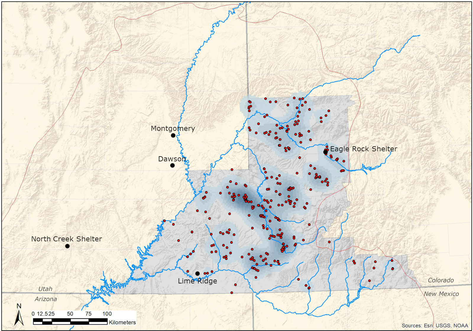
Figure 1. General locations of key sites discussed in the text and the distribution of Paleoindian points analyzed in this study, indicated by red dots. The boundary of the Colorado Plateau is marked by a red line, while the central Colorado Plateau study area is shaded gray. Blue shading reflects high-density areas of points identified by a geographic information system–based kernel density analysis.
Generally speaking, the climate of the central Colorado Plateau can be described as warm and dry or cool and wet, correlating with elevation (Hall Reference Hall and Vierra2018). Following a general warming trend during the Bølling-Allerød (14,600–12,900 cal BP), the region experienced a cooler, wetter period during the Younger Dryas (12,900–11,700 cal BP). This period of increased moisture resulted in increased availability of water in springs, marshes, and cave/alcove seeps (Hall Reference Hall and Vierra2018; Withers and Mead Reference Withers and Mead1993). Together, the cooler and wetter conditions allowed for montane plant species (e.g., spruce [Picea sp.], Douglas fir [Pseudotsuga menziesii], water birch [Betula occidentalis], mountain mahogany [Cercocarpus ledifolius], and bigtooth maple [Acer grandidentatum]) to shift downward in elevation by as much as 900 m (Withers and Mead Reference Withers and Mead1993). The temperature requirements of modern plant species suggest that during the Younger Dryas, the annual mean temperature in southeastern Utah was 3°C–4°C (~5°F–7°F) cooler than today (Betancourt Reference Betancourt1984; Withers and Mead Reference Withers and Mead1993).
The onset of the early Holocene (11,700–7000 cal BP) was marked by an abrupt shift to a warmer, drier climate, with present-day conditions being reached by about 9000 cal BP (Hall Reference Hall and Vierra2018). Regional drying is indicated by a lack of speleothem growth, lowering pluvial lake levels, and a shift in vegetation communities. Plant species continued to exist at lower elevations than today, but by 11,000 cal BP bigtooth maple and mountain mahogany had begun to shift upward in elevation (Withers and Mead Reference Withers and Mead1993). While this was generally a period of increasing aridity, the abundance of Gambel oak (Quercus gambelii) and reticulated hackberry (Celtis reticulata) suggests more reliable summer moisture and the establishment of monsoonal patterns. Notably, the thick soils that developed across much of the region during the late Pleistocene began to erode, while seeps and springs dried up, leading to the disappearance of most mesophytic species (Betancourt Reference Betancourt1984; Coats et al. Reference Coats, Cole and Mead2008; Hall Reference Hall and Vierra2018; Withers and Mead Reference Withers and Mead1993).
Materials and Methods
Two rounds of data collection were conducted during this research. Initial data collection consisted of reviewing existing records accessible in online databases for Colorado (COMPASS) and Utah (PreservationPro, now known as Sego). Data from these sources provide typological information for projectile points and site locations. Only records with descriptions or images of diagnostic projectile point types were included here; thus, records with general descriptions such as Paleoindian were excluded. The second round of data collection took place at Canyons of the Ancients Visitor Center and Museum (CAVM) in Dolores, Colorado, and Edge of the Cedars State Park Museum in Blanding, Utah. All Paleoindian projectile points curated at both repositories were analyzed and photographed. In addition to the identification of projectile point types, standard morphological and technological attributes were documented. A review of existing literature was conducted for southeastern Utah and southwestern Colorado and led to the identification of additional projectile points not recorded in online databases or curated at regional repositories. Site location data were assessed at the county level for consistency and discretion and then put into ArcGIS to document diachronic changes in artifact distributions and land use strategies. A complete list of points that were used here, with associated information (site numbers, catalog numbers, curation facilities, and databases), can be found in Supplemental Table 1.
The projectile point typology employed here closely follows that defined by Pitblado (Reference Pitblado2003, Reference Pitblado, Brunswig and Pitblado2007) with the addition of fluted point types. Folsom and Midland points are combined into a single technological complex due to their frequent temporal and spatial associations (Amick Reference Amick1995; Frison Reference Frison and Carlisle1988; Lassen Reference Lassen2015). Similarly, the type names Allen and Frederick are combined into a single “Allen” category here following Pitblado (Reference Pitblado, Brunswig and Pitblado2007). The resulting typology captures nearly all of the variation observed in Paleoindian projectile points found across the study area: Clovis, Folsom/Midland, Agate Basin, Hell Gap, Plainview, Cody, Angostura, and Allen. While Paleoindian technologies are generally associated with the late Pleistocene, early lithic technologies in western North America require flexibility in terminology, as some point types continue well into the early Holocene (e.g., Graf and Schmitt Reference Graf and Schmitt2007). Therefore, the temporal divisions Early, Middle, and Late Paleoindian were eschewed here in favor of climatologically based terms to better reflect the relationships between human adaptations and environmental conditions. Clovis points generally date to the end of the Bølling-Allerød interstadial, approximately 13,400–12,700 cal BP (Miller et al. Reference Miller, Holliday, Bright, Graf, Ketron and Waters2013; Sanchez et al. Reference Sanchez, Holliday, Gaines, Arroyo-Cabrales, Martínez-Tagüeña, Kowler, Lange, Hodgins, Mentzer and Sanchez-Morales2014; Waters and Stafford Reference Waters and Stafford2007). While they are dated to varying degrees of certainty, Folsom, Agate Basin, Hell Gap, and Plainview all occur during the Younger Dryas, approximately 12,900–11,700 cal BP (Holliday Reference Holliday2000; Holliday et al. Reference Holliday, Johnson, Miller, Holliday, Johnson and Knudson2017; Lee et al. Reference Lee, Lee and Turnbull2011; Surovell et al. Reference Surovell, Boyd, Vance Haynes and Hodgins2016). Cody, Angostura, and Allen points are poorly dated compared with other Paleoindian types but appear to have been used well into the early Holocene, approximately 11,700–8500 cal BP (Hill Reference Hill2005; Hill and Knell Reference Hill, Knell, Knell and Muñiz2013; Holliday Reference Holliday2000; Larson Reference Larson, Bousman and Vierra2012; Pitblado Reference Pitblado2003, Reference Pitblado, Brunswig and Pitblado2007). The date ranges used here are largely derived from Plains-based chronologies and are assumed to reflect early hunter-gatherer occupations on the central Colorado Plateau. However, dated cultural components in the study area are needed to ultimately confirm this assumption.
Toolstone selection was assessed by macroscopically identifying the lithic materials used to produce projectile points. The source for an obsidian point was determined using X-ray fluorescence analysis. Identifications made by other researchers were used when that information was available in the existing literature and online databases. Cherts, agates, and chalcedonies were grouped into a general category of cryptocrystalline silicates (CCS) to reduce interobserver error in material identifications. All quartzites were grouped together into a single quartzite category. In addition to documenting potential changes in toolstone preference through time, this analysis also enabled an assessment of local versus nonlocal material use based on visual identifications and comparisons with the lithic type collection housed at CAVM.
Site distribution and land use were assessed by point type at the county level. Overall frequencies of points were documented throughout the study area. Point densities were then scaled to 1,000 km2 to account for differences in the sizes of counties. Scaling the densities provides a more accurate reflection of point distributions and allows for meaningful comparisons between counties. Similarly, since the durations of projectile point types were not equal, raw counts may not meaningfully reflect land use intensity. Thus, point frequencies were normalized to 100-year increments to document spatiotemporal patterns in land use intensity. Land use intensity is assessed here based on the amount of time that was available to amass the quantity of a given point type, in a given area. That is to say, by assessing point frequencies based on standard units of time, we can more comparably evaluate the accumulation of points through time. It should be noted, however, that this approach assumes a constant rate of discard throughout the duration of each point type. This assumption may or may not reflect realities of Paleoindian technological organization strategies.
While modern political boundaries may not have relevance for Paleoindian artifact distributions and land use practices, the decision to assess data here at the county level was made for several reasons. First, only county-level provenience exists for some artifacts; thus, a more refined location cannot be identified for those artifacts. Additionally, reporting the distributions and densities of projectile points at the county level is standard practice in the existing literature (e.g., Anderson et al. Reference Anderson, Shane Miller, Yerka, Gillam, Johanson, Anderson, Goodyear and Smallwood2010; Ballenger et al. Reference Ballenger, Holliday, Kowler, Reitze, Prasciunas, Shane Miller and Windingstad2011). Therefore, data are presented at the county level to make the results comparable with other studies.
The distribution of points is commonly used to investigate a range of questions about Paleoindian archaeology. State and national databases such as COMPASS, PreservationPro, and the Paleoindian Database of the Americas are frequently employed in spatial analyses of points (e.g., Anderson and Gillam Reference Anderson and Gillam2000; Anderson et al. Reference Anderson, Goodyear, Kennett and West2011; Miller Reference Miller2016; Shott Reference Shott2013; Smallwood Reference Smallwood2012; Smallwood et al. Reference Smallwood, Jennings, Anderson and Ledbetter2015; Tune Reference Tune2016). Such datasets led Anderson (Reference Anderson, Tankersley and Isaac1990, Reference Anderson, Nassaney and Sassaman1995) to propose a “staging area” model of the initial peopling of eastern North America. Anderson and Gillam (Reference Anderson and Gillam2000) argue that areas with dense concentrations of points may represent locations where macroband aggregation events occurred because of accessibility to abundant resources. Smallwood (Reference Smallwood2012) found support for the staging area model in Clovis assemblages from the southeastern United States and contends that a place-oriented settlement strategy led to regionalization of populations as early as Clovis times.
The secure context of intact, stratified Paleoindian sites has provided a wealth of information about late Pleistocene–early Holocene lifeways. However, a large portion of Paleoindian points and sites are only known from surface sites throughout much of the continent. Therefore, spatial data associated with points have been extremely valuable in studying Paleoindian archaeology—although a number of potential biases and limitations in the data are well known for points from surface contexts. Factors potentially influencing the distribution of Paleoindian points include modern populations, archaeological survey intensity, land cover, and geomorphology (Anderson et al. Reference Anderson, Shane Miller, Yerka, Gillam, Johanson, Anderson, Goodyear and Smallwood2010; Buchanan Reference Buchanan2003; LaBelle Reference LaBelle2005; Loebel Reference Loebel2012; Meltzer and Bever Reference Meltzer and Bever1995; Prasciunas Reference Prasciunas2011; Shott Reference Shott2002). However, Miller (Reference Miller2016) found that throughout the southeastern United States geographic concentrations of Clovis points were best explained by natural factors such as the intersection of streams, physiographic boundaries, and lithic raw material sources. Furthermore, Vance's (Reference Vance2011) research at the Lime Ridge site, which is a surface site, has demonstrated that spatial integrity may still exist even when sites consist only of surface deposits.
Another modern factor, somewhat unique to western North America, that has affected the Paleoindian record is the lack of archaeologists conducting systematic surveys (LaBelle Reference LaBelle2005). This is particularly true for much of the Colorado Plateau. While there are a few notable examples of systematic surveys and archaeological research devoted to the Paleoindian period (Judge Reference Judge1973; Pitblado Reference Pitblado1998, Reference Pitblado2003; York Reference York1991), the area has been largely overlooked by Paleoindian archaeologists. In 2019, I initiated a Paleoindian survey and research program focused on investigating the Paleoindian occupation of southwestern Colorado and the surrounding areas. This work is being conducted in part through an undergraduate field school, which trains students in field methods and also provides them with directed research opportunities. In just the first field season multiple previously unknown Paleoindian sites, including two Clovis sites, were identified. Subsequent field seasons will further investigate these sites, as well as continue conducting surveys to identify additional sites. Results of this ongoing work will be presented in upcoming publications.
Results
There are 173 Paleoindian projectile points from the central Colorado Plateau that were identified to a specific type (3.1 points per 1,000 km2; Figure 2; Table 1). There are an additional 41 Paleoindian points recorded in state site files that are not identified to a specific type. These untyped points are not included in analyses here because their typological assignment cannot be verified. Allen points are up to nine times more common than any other point type in the study area. Clovis, Folsom, Agate Basin, Cody, and Angostura points all occur in relatively equal frequencies, while Hell Gap and Plainview are the least frequent. While the dataset analyzed here may be relatively small, especially compared with datasets from more recent cultural periods, this is a substantial expansion of what has previously been reported (e.g., Pitblado Reference Pitblado2003). The research presented here is just a start to compiling a comprehensive dataset and assessing patterns at regional and interregional scales. As more research is devoted to late Pleistocene and early Holocene occupations of the region, this dataset will inevitably continue to increase.

Figure 2. Representative sample of Paleoindian points identified throughout the central Colorado Plateau: (a) Clovis (42SA32467); (b) Clovis (42SA16857); (c) Folsom (S-37B); (d) Folsom (5MT4028); (e) Folsom (5MT604); (f) Agate Basin (5MT2858); (g) Agate Basin (5LP5609); (h) Eden (5GN2610); (i) Plainview (2014.7.1); (j) Hell Gap (5DL1059); (k) Angostura (78.3.136); (l) Allen (78.31.33); (m) Allen (5MN740). Site and catalog numbers correspond to the inventory provided in Supplemental Table 1.
Table 1. Frequency of Paleoindian Point Types per County.

Note: Point densities (per 1,000 km2) by county are given in parentheses. Windust and other Western Stemmed types are excluded because of small sample sizes.
Typology and Chronology
The typological sequence of points observed on the central Colorado Plateau mirrors that of neighboring regions (Figure 3). Archaeological evidence indicates that the area was initially occupied during the Bølling-Allerød by people carrying Clovis points (n = 20). At this time there is no archaeological evidence to support an earlier human presence in the region. The ensuing onset of a cooler and wetter regional climate during the Younger Dryas does not appear to have negatively impacted human populations in the region, at least in terms of overall frequencies of points. A similar pattern has been identified across the Southwest (Ballenger et al. Reference Ballenger, Holliday, Kowler, Reitze, Prasciunas, Shane Miller and Windingstad2011). The Younger Dryas–age occupations are represented by Folsom/Midland (n = 20) and Agate Basin (n = 20), which have durations entirely within the ~1,200-year span of the Younger Dryas. While Hell Gap (n = 7) and Plainview (n = 6) emerge during the Younger Dryas, these point types remained in use into the early Holocene. Continued occupation of the region into the early Holocene is represented by Cody (n = 22), Angostura (n = 26), and Allen (n = 52).

Figure 3. Central Colorado Plateau Paleoindian chronology.
The chronologies for Clovis (Waters and Stafford Reference Waters and Stafford2007; see also Haynes et al. Reference Haynes, Anderson, Reid Ferring, Fiedel, Grayson, Vance Haynes, Holliday, Huckell, Kornfeld, Meltzer, Morrow, Surovell, Waguespack, Wigand and Yohe2007), Folsom (Surovell et al. Reference Surovell, Boyd, Vance Haynes and Hodgins2016), and Agate Basin (Lee et al. Reference Lee, Lee and Turnbull2011) have all been recently refined, while date ranges for the later types of Hell Gap, Plainview, Angostura, and Allen are not as well documented (Hill Reference Hill2005; Holliday Reference Holliday2000; Holliday et al. Reference Holliday, Johnson, Miller, Holliday, Johnson and Knudson2017; Larson Reference Larson, Bousman and Vierra2012; Pitblado Reference Pitblado2003, Reference Pitblado, Brunswig and Pitblado2007). Recently, an Angostura point was recovered during survey at site 5DL4617 in Dolores County, Colorado, where a rock-lined hearth was also observed and partially sampled (Loebig et al. Reference Loebig, Thompson and Fluder2016). A fragment of wood charcoal from the hearth returned a radiocarbon age of 7870 ± 30 14C years BP (Beta-454762; δ13C = −21.3‰), which is calibrated at 2σ to 8770–8580 cal BP based on the IntCal 13 calibration curve using OxCal 4.3 (Bronk Ramsey Reference Bronk Ramsey2009). The Angostura point was recovered from the ground surface approximately 125 m from the hearth, which was also visible on the surface. As such, a direct association between the radiocarbon-dated hearth and the point is equivocal at this time. However, the age of approximately 8660 cal BP conforms to the expected date range for Angostura (Holliday Reference Holliday2000; Larson Reference Larson, Bousman and Vierra2012; Pitblado Reference Pitblado2003, Reference Pitblado, Brunswig and Pitblado2007). The existence of an early Holocene hearth on the central Colorado Plateau demonstrates that intact and datable cultural deposits exist in the region.
While the point types documented here generally meet the typological and chronological expectations of the region (sensu Pitblado Reference Pitblado2003), there are a few significant exceptions. A crescent biface made from chert was recovered from a surface context in San Juan County, near the Utah-Colorado border (Tune and Fox Reference Tune and Fox2020; Figure 4a). This is currently the only crescent documented from the northern Colorado Plateau (Tune and Fox 2020). While there is considerable debate about their age and use, it is generally agreed that crescents are associated with paleo-wetlands in the Great Basin and California (Amick Reference Amick and Beck1999; Beck and Jones Reference Beck and Jones2010; Sanchez et al. Reference Sanchez, Erlandson and Tripcevich2016; Smith et al. Reference Smith, Pattee, Pellegrini, Finley and Fagan2014). Rarely recovered from dated contexts, crescents are assumed to be early Holocene in age (~10,000–9000 cal BP) and likely associated with the Western Stemmed Tradition (Smith et al. Reference Smith, Pattee, Pellegrini, Finley and Fagan2014).

Figure 4. Great Basin–related artifacts documented from the central Colorado Plateau: (a) crescent biface (S-30B); (b) Windust (5SM2423); (c) Windust (78.45.157); (d) Great Basin Stemmed (G-28B). Site and catalog numbers correspond to the inventory provided in Supplemental Table 1.
Two parallel-sided stemmed points with deeply concave bases and prominent shoulders were identified (Figure 4b–c). One is made from a tan chert (Figure 4b), while the other is from particularly fine-grained, light gray quartzite (Figure 4c). Stemmed points with concave bases are common throughout the region and are typically identified as Bajada points from the Early Archaic period (Irwin-Williams Reference Irwin-Williams1973; Pitblado Reference Pitblado2003). However, the exceptionally straight parallel sides, squared shoulders, and parallel horizontal-to-oblique flaking of these two points do not conform to the traditional Bajada type. Rather, they closely match descriptions and examples of Windust points from the Great Basin (Willig Reference Willig1989). A third Windust point is recorded in the Utah State site files from San Juan County. Windust is an early Holocene (~10,000–9000 cal BP) point type associated with the Great Basin (Lohse and Schou Reference Lohse, Schou, Carlson and Magne2008) and is generally contemporaneous with Allen points, which are more common in the Southern Rockies (Pitblado Reference Pitblado2003).
In addition to Windust, points that technologically and morphologically conform to the Western Stemmed Tradition were identified here and tentatively classified as such (Figure 4d). Points classified as Great Basin Stemmed and Western Stemmed Tradition are also documented in state site files from the study area. Unfortunately, these records lack associated information needed to further assign the points to a specific type. Because of the extreme morphological variability, muddled typologies, and uncertain radiocarbon-based chronology within the Western Stemmed Tradition (Goebel and Keene Reference Goebel, Keene, Parezo and Janetski2014; Rosencrance Reference Rosencrance2019), these points were excluded from more detailed analyses here. In spite of these ambiguities, however, the presence of Great Basin–related points on the central Colorado Plateau should not be overlooked. Windust and other stemmed types, along with a crescent biface in southeastern Utah, strengthen previous arguments made by Black (Reference Black1991) and Pitblado (Reference Pitblado1998) for a Great Basin association during the Pleistocene-Holocene transition. A more rigorous, quantitative analysis of these points is needed to further substantiate a Great Basin–Colorado Plateau connection.
Toolstone Selection
Local toolstone-quality materials consist of CCS and quartzites. Where data are available, points are made from CCS (n = 54) more frequently than quartzite (n = 47). This general pattern holds true for most point types but is particularly exaggerated in Clovis points. While later points are made 0.5–2.0 times more frequently from CCS than quartzite, Clovis points are made almost exclusively from CCS (Table 2). Counter to this general pattern, Angostura and Cody points are most frequently made from quartzite, which Pitblado (Reference Pitblado2003) also observed for Angostura throughout Utah and Colorado.
Table 2. Paleoindian Toolstone Selection on the Central Colorado Plateau.

Nearly all of the specimens documented in this study are visually similar to local lithic material types. Ballenger and colleagues (Reference Ballenger, Holliday, Kowler, Reitze, Prasciunas, Shane Miller and Windingstad2011) noted a similar pattern in Clovis toolstone selection across the larger Southwest region. This pattern of toolstone selection runs counter to much of the existing literature and assumptions about Paleoindian lithic technologies (e.g., Amick Reference Amick1996; Goodyear Reference Goodyear, Ellis and Lothrop1989; Holen Reference Holen2004; Kelly and Todd Reference Kelly and Todd1988). Conventional wisdom holds that as initial occupants of the Americas, Paleoindian foragers used a relatively wide range of lithic materials. Relatively high percentages of Early Paleoindian points are expected to be made from nonlocal materials, which reflects extended mobility ranges and landscape learning behaviors (Amick Reference Amick1996; Boldurian and Cotter Reference Boldurian and Cotter1999; Buchanan et al. Reference Buchanan, Andrews, Kilby and Eren2019; Goodyear Reference Goodyear, Ellis and Lothrop1989; Holen Reference Holen2004). Notably, however, Folsom toolstone selection in the neighboring Upper Gunnison Basin was focused on local quartzites from within the basin (Andrews Reference Andrews2010; Morgan Reference Morgan2015; Stiger Reference Stiger2008).
The only obvious nonlocal Paleoindian materials identified from the study area are two points made from chert and obsidian. The first is a fragmentary point with Clovis-like attributes that was visually identified as Tiger chert, which is also known as Bridger Basin or Green River Formation chert (Bamforth Reference Bamforth2015; Yohe and Bamforth Reference Yohe and Bamforth2013). The majority of items in the Mahaffy cache from Boulder, Colorado, are also made from Tiger chert (Bamforth Reference Bamforth2015; Yohe and Bamforth Reference Yohe and Bamforth2013). This material is best known to originate near the Wyoming border around the northwest corner of Colorado and the northeast corner of Utah (Bamforth Reference Bamforth2015). As such, there is a straight-line distance of approximately 320 km (200 mi) between the general source area and the discard site.
The second nonlocal material is an Allen point made from an opaque, black obsidian. The point was recovered in Cortez, Colorado, during a survey conducted in 2008 by the Hisatsinom Chapter of the Colorado Archaeology Society. The artifact is permanently curated at CAVM (2008.24.19108.1). In 2019 the point was submitted to the Northwest Research Obsidian Studies Laboratory for energy-dispersive X-ray fluorescence trace element provenance analysis. Results of the analysis indicate that the trace elements present in the Allen point correlate with a single known source, Obsidian Ridge, near Santa Fe, New Mexico (Nyers Reference Nyers2019). There is a straight-line distance of approximately 260 km (~160 mi) between the toolstone source location and the discard site.
Site Distribution and Land Use
The density of points is assessed at the county level by point type (Table 1). Since the nine counties included in this study vary in size from 1,404 to 20,546 km2, the frequencies of points were normalized to 1,000 km2 for each county. Paleoindian points occur on an average of 3.1 points per 1,000 km2 across the study area. While San Juan County, Utah, has one of the overall highest frequencies (n = 29), it is also the largest county by area; thus, it has one of the lowest densities of points (1.4/1,000 km2). San Miguel County (9.3/1,000 km2) followed by Montezuma County (5.5/1,000 km2) in Colorado are the densest areas for Paleoindian points.
Point frequencies were normalized to 100-year increments because the durations of Paleoindian point types are variable (Table 3). While number of points does not necessarily reflect number of people, spatiotemporal patterns may reflect changes in the relative intensity of land use. Clovis (2.9/100 years) and Folsom (4.4/100 years) are the most common points when durations are considered, while Hell Gap, Plainview, Cody, and Angostura are all the least common point types across the region (<1.0/100 years). Clovis and, to a lesser extent, Folsom are generally considered to be technologies used by pioneering populations. Therefore, it is somewhat surprising that these types represent the most intense period of land use. It should be noted, however, that some point types are more thoroughly dated than others, which may affect interpretations. Likewise, given the relatively small sample sizes for various point types, the identification of additional points may significantly alter these interpretations.
Table 3. Land Use Intensity Normalized to 100-Year Increments.

Note: Windust and other Western Stemmed types are excluded because of small sample sizes.
Overall point frequencies suggest that land use remained relatively constant throughout the Pleistocene-Holocene transition. Then, during the early Holocene, regional land use increased. However, consideration of the durations of Paleoindian points suggests a different story of initial regional occupation. Rather, Clovis, as the earliest technology, provides a baseline for initial human occupation, which was followed by a period of more intense land use by Folsom hunter-gatherers during the onset of the Younger Dryas. Throughout the remainder of the Pleistocene there appears to have been a decline in land use across the region. Then, with the onset of the early Holocene, there was an intensification in land use associated with Allen points. However, the temporal overlap of Agate Basin, Hell Gap, and Plainview, and that of Cody, Angostura, and Allen, should also be considered. As these technologies appear to have been contemporaneous throughout much of their durations, the region seems to have experienced a proliferation in lithic technologies and land use strategies beginning during the Younger Dryas and continuing into the Holocene. So rather than a post-Folsom decline followed by an Allen rebound, the intensity of land use may have remained fairly constant while hunter-gatherer technologies began to diversify. The diversification of contemporaneous point types may reflect emerging sociocultural complexities that developed during the Pleistocene-Holocene transition.
Early Hunter-Gatherer Occupation of the Central Colorado Plateau
The central Colorado Plateau was initially occupied by Clovis groups during the Bølling-Allerød, which aligns with the generally accepted timing for the rest of North America (Goebel et al. Reference Goebel, Waters and O'Rourke2008). While Younger Dryas–driven climate change has been noted throughout the American Southwest (Hall Reference Hall and Vierra2018), based on land use intensity and overall artifact frequencies, it appears that the onset of the Younger Dryas did not negatively impact human populations here. In fact, the most intense period of land use occurred immediately after the onset of the early Younger Dryas, when Folsom groups occupied the landscape. Following the Folsom occupation, Agate Basin, Hell Gap, and Plainview groups continued to rely on local resources in this region throughout the Younger Dryas. As modern environmental conditions began to develop in the early Holocene, people carrying Plains-related point styles moved into the region.
While the point styles present in the region indicate that people continually (albeit intermittently) occupied the area as early as Clovis, the intensity of land use was relatively low compared with neighboring regions. This suggests that the central Colorado Plateau was a marginal landscape at the end of the Pleistocene and may have existed at the edges of larger cultural territories. However, the reliance on local lithic materials suggests that pioneering populations quickly learned the local lithic landscape.
The relative intensity of land use appears to be reduced during the latter portion of the Younger Dryas and early Holocene; however, this apparent pattern requires further consideration. Most of the earlier Paleoindian point types have well-defined date ranges of a few hundred years. Later Paleoindian point types, particularly Angostura and Allen, remain poorly dated and may have been in use for as much as 2,700 years (Hill Reference Hill2005; Holliday Reference Holliday2000; Holliday et al. Reference Holliday, Johnson, Miller, Holliday, Johnson and Knudson2017; Larson Reference Larson, Bousman and Vierra2012; Pitblado Reference Pitblado2003, Reference Pitblado, Brunswig and Pitblado2007). Essentially, while Allen points are the most frequent Paleoindian point type documented in the region, their longer duration means more time to accumulate those points.
The data analyzed here indicate that Paleoindian knappers used almost exclusively local lithic materials for point production. While this pattern differs dramatically from some classic Paleoindian sites such as Blackwater Draw (Boldurian and Cotter Reference Boldurian and Cotter1999), the reliance on local lithic sources is well documented in neighboring areas such as the Upper Gunnison Basin (Andrews Reference Andrews2010; Morgan Reference Morgan2015; Stiger Reference Stiger2008). Thus, Paleoindian lithic technological organization may be better characterized by flexibility than by a single, uniform organizational strategy. If this is the case, it may indicate that we should rethink assumptions about the speed at which late Pleistocene hunter-gatherers explored, mapped, and adapted to new landscapes.
A Clovis point documented from southeastern Utah that is made from chert originating in the Upper Green River basin may reflect early movement into the region that was guided by rivers, though not necessarily via the bottoms of narrow canyons. There is also a distinct western influence from the Great Basin reflected in the early lithic technologies of the central Colorado Plateau (Figure 5). Black (Reference Black1991) and Pitblado (Reference Pitblado1998) have previously noted such an influence from the west and suggest that it is rooted in the Western Stemmed Tradition. Recently Hartman's (Reference Hartman2019) investigation of Intermountain West and Great Plains Paleoindian technologies has shown additional technological influences moving through the Intermountain West. Byers (Reference Byers2012) reports Clovis-like, Folsom, Cody, and Western Stemmed points all occurring in an aeolian deposit at the Dawson site, in the San Rafael Desert in east-central Utah. The Eagle Rock Shelter, in the Lower Gunnison Canyon of Colorado, reportedly contains Western Stemmed Tradition–like points in Younger Dryas–age deposits (Dudash and Harrison Reference Dudash and Harrison2014); however, more research is needed to confirm this. The Windust points and crescent biface reported in this study represent part of a lithic tool assemblage that is virtually indistinguishable from early Holocene assemblages on the Columbia Plateau in southeastern Oregon (Willig Reference Willig1989). The identification of these Great Basin–related technologies supports and strengthens the idea of a Great Basin connection on the central Colorado Plateau.

Figure 5. Generalized movement of people and lithic industries onto the central Colorado Plateau. State borders are shown as solid gray lines, physiographic boundaries are shown as dashed lines, and directions of movement onto the central Colorado Plateau are shown as blue arrows. Crescent bifaces and stemmed points, such as Windust, are characteristic of lithic industries centered to the west in the Great Basin, Columbia Plateau, and Far West. Cody (Eden and Scottsbluff) and Allen points are characteristic of lithic industries centered to the north and east in the High Plains and Rocky Mountains. Clovis and Folsom are characteristic of lithic industries centered to the south in the Southern Plains and Southwest.
Projectile point types that are generally thought of as characteristic of the High Plains occur across the central Colorado Plateau in comparable frequencies as most other point types. While Cody sites are documented from the Great Basin to the Great Lakes, their core distribution is centered in the Plains (Knell and Muñiz Reference Knell and Muñiz2013). The frequency of Scottsbluff and Eden points noted here indicates a Cody extension onto the central Colorado Plateau. Similarly, while Angostura points are most commonly thought of as being associated with the Rocky Mountains and Great Plains (Pitblado Reference Pitblado2003; Thoms Reference Thoms1993), this and other recent research is beginning to expand the geographic distribution of Angostura points to include the Colorado Plateau (Miller et al. Reference Miller2016). Movement of people onto the central Colorado Plateau from the south is indicated by the presence of obsidian that originated in the Jemez Mountains, near Santa Fe, New Mexico. Hamilton and colleagues (Reference Hamilton, Buchanan, Huckell, Holliday, Shackley and Hill2013) identified a similar conveyance of lithic materials moving in the opposite direction. They report the presence of chert from the Chuska Mountains in northeastern Arizona occurring in the Mockingbird Gap Clovis assemblage in central New Mexico (Hamilton et al. Reference Hamilton, Buchanan, Huckell, Holliday, Shackley and Hill2013).
The scenario that is emerging is one where people, and lithic industries, arrived on the central Colorado Plateau from across much of western North America and quickly learned, mapped, and exploited local landscapes and resources. Because of the apparent interregional coalescence that occurred, the central Colorado Plateau may be uniquely situated to provide insight into questions regarding the relationship of Clovis and Western Stemmed points and landscape learning processes. Lithic industries on the central Colorado Plateau were being influenced by populations centered outside of the region. As such, if we are interested in understanding the interactions of people carrying Clovis and Western Stemmed points, then the central Colorado Plateau may be ideally situated to investigate this question.
Moving forward, future research should focus on systematically surveying the central Colorado Plateau to identify early archaeological components. Quantitative analyses of Western Stemmed points from the Colorado Plateau may provide much needed data to help refine chronologies and typologies, as well as improve our understanding of hunter-gatherer adaptive behaviors. Ultimately, there is great research potential in this historically overlooked region where intact deposits containing late Pleistocene and early Holocene materials may exist—which would help substantiate or disprove the assertions presented here.
Supplemental Materials
For supplementary material accompanying this article, visit https://doi.org/10.1017/aaq.2020.19.
Supplemental Table 1. Inventory of Projectile Points Used in This Study.
Acknowledgments
This research would not be possible without the assistance of many people who were willing to share time and data with me. Tracy Murphy and Bridget Ambler at the Canyons of the Ancients National Monument and Visitor Center graciously provided time and workspace for me to document many of the artifacts used in this study. Likewise, Jonathan Till at the Edge of the Cedars State Park Museum provided access to artifacts and space to study them in Utah. Thanks go to Kelly McAndrews and Woods Canyon Archaeological Consultants Inc. for help accessing site reports. I am grateful for the help of Arie Leeflang, who helped me navigate the PreservationPro online database and access to spatial data in Utah. Doug Loebig and Brian Yaquinto provided local insight into the archaeological record of southwestern Colorado. I thank Vance Holliday, Bonnie Pitblado, and Bruce Huckell for their conversations and insights about western Paleoindian archaeology. Thanks go to Alfredo Reyes and Hazel Palacios for their help translating the abstract. I thank the Fort Lewis College, Faculty Development Grants–Traditional Scholarship/Research Committee for funding my publication expenses. I am thankful for the helpful comments and suggestions of three anonymous reviewers, which greatly improved this article. Finally, I want to acknowledge the Indigenous peoples who have called the Colorado Plateau home for at least 13,000 years. I am grateful for the opportunity to study material culture left behind by people who lived here so long ago.
Data Availability Statement
No original data were presented in this article.


