
1.0 INTRODUCTION
Bird strike is a collision between an airborne animal, usually a bird or bat, and a human-made vehicle, especially aircraft. Bird strikes are a significant threat to flight safety and have caused a number of accidents with human casualties(Reference Beason, Nohara and Weber1,Reference O'donnell2) . In China, with the sustained growth of flights and continuous improvement of ecological environment, the working pressure of bird-strike avoidance at airports increases annually, which brings much more loss than other factors(Reference Li and Shi3). According to the bird-strike information collected by the Civil Aviation Administration of China (CAAC), the number of bird strikes is 3,816 from January to December in 2015, which increased by 13.07% more than the previous year. Among the 3,816 bird strikes, the number of incidents was 185, accounting for 49.47% of the total incidents, which ranked the first in all the incident types. The number of bird-strike reports that occurred at the airport responsibility area is 508, up 7.86% than last year(Reference Zhang4).
Under the urgent circumstances of bird-strike avoidance, the airports in the world use a wide range of technical means, such as many bird deterrents such as gas cannons, sound devices, High-Power Acoustic Devices (HPAD) and firecracker launchers. In the initial stage of using these deterrents, they had a certain effect on bird repellent; however, after running a period of time, birds developed tolerance to these deterrents, ignoring the empty threats the deterrents represent, called habituation(Reference Liu, Chen and Shao5).
Therefore, the problem faced by airport operators using deterrents to keep the birds away is preventing the birds from becoming used to the repeated application of deterrents. Because they constantly hear and see deterrents that activate on a regular or irregular schedule, birds learn that the threat is meaningless. The challenge is to maintain the efficiency of the deterrents by keeping the birds from habituating to and ignoring the deterrents without harming the birds. Habituation can be slowed or perhaps prevented by not continuously exposing the birds to the deterrents(Reference Nohara, Beason and Clifford6). Over the past 40 years, airport-based avian radar has been an interdisciplinary subject attracting interests of researchers and consultants over the world. Some excellent products have been developed and applied in many civil or military airports, such as Merlin Radar(Reference Anderson7), Accipiter Radar(Reference Nohara and Unkrainec8) and Robin Radar(9), acting as a powerful force multiplier to wildlife management personnel at airports by providing wide-area, all-weather, day-night automatic situational awareness. Some of these systems are also combined with infrared and visible light detectors for target recognition. However, little information was released on the bird repellent strategies of these avian detection systems.
The objective of this paper is to introduce an intelligent linkage system of avian detection and repellent, which could help the airport operators to keep birds away as well as provide real-time bird surveillance information to the airport air traffic control unit. In this paper, the means of bird repellent and detection are combined. The birds are repelled, activated by bird information collected by avian radar, infrared and visible light. An intelligent decision-making method is proposed for bird repellent at airports after a bird-strike risk assessment. The Support Vector Machine (SVM) is used to make the optimal decision, when the best starting time, working mechanism and combination mode of the deterrents are selected. The proposed mechanism could solve the problem of bird tolerance to the repetitive operation of deterrents, greatly improving the bird repellent effects.
The remainder of this paper is organised as follows. In Section 2, the system architecture for airport-based avian detection and repellent is introduced. Then, the methods for the bird-strike risk assessment and the SVM-based intelligent decision-making are discussed, respectively, in Sections 3 and 4. Some examples for bird repellent are provided with the real data at airports in Section 5 to test the proposed method. Some conclusions close the paper in Section 6.
2.0 SYSTEM ARCHITECTURE
As the architecture shown in Fig. 1, the airport-based linkage system of avian detection and repellent includes the modules of avian sensors, multi-source information fusion, bird information extraction, bird information database, bird-repelling decision-making and deterrents(Reference Chen and Li10,Reference Chen, Ning and Li11) . Multi-source echo information of the low-altitude airspace around the airport is collected by the sensors of radar, infrared and visible light, and then transmitted to the module of multi-source information fusion, which could fuse the multi-source information to form the original measurement data containing the flying bird targets in low-altitude airspace. Avian radars are used to provide 360° coverage of the low-altitude airspace around the airport, while the infrared and visible light sensors are added to identify the targets. The original data is processed by the module of bird information extraction, so the bird information is extracted and transmitted to the module of bird-strike risk assessment and saved to the bird information database simultaneously. In the database, a track is automatically formed for each bird or flock, in addition to the speed, heading and size information. Thus, the bird activity pattern is provided by statistical analysis of the mass of bird information. After the bird-strike risk assessment, the module of bird-repelling decision-making is started with the data of bird information and bird-strike risk level. Therefore, the multiple deterrents of gas cannons, sound devices, HPADs and firecracker launchers are activated following the intelligent bird repellent decision. Finally, the operation situations of the deterrents are fed back, and the bird repelling decision is modified due to the latest risk assessment result.

Figure 1. Linkage system architecture for airport-based avian detection and repellent.
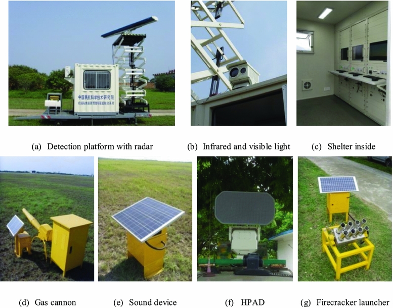
Figure 2 provides the outfield experiment pictures of the linkage system at Beihai airport, Guangxi Province, China, including the detection platform with radar, the infrared and visible light sensors, the equipments inside the shelter, and several bird deterrents of gas cannon, sound device, HPAD and firecracker launcher. Since the southern end of the runway is the main take-off and landing point of the aircraft, most of the deterrents were installed in this area.

Figure 2. Outfield pictures for airport-based avian detection and repellent system.
Figure 3 shows the equipment layout of the intelligent linkage system tailor-made for Beihai airport, where the detection platform ‘![]() ’, the HPAD ‘
’, the HPAD ‘![]() ’ and the firecracker launchers ‘
’ and the firecracker launchers ‘![]() ’ were located near the light station, and the eight gas cannons ‘
’ were located near the light station, and the eight gas cannons ‘![]() ’ and two sound devices ‘
’ and two sound devices ‘![]() ’ were installed at the southern end of the runway.
’ were installed at the southern end of the runway.
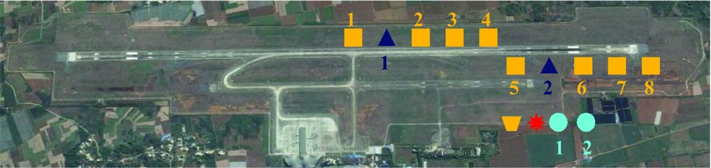
Figure 3. Equipment layout of the system at Beihai airport.
3.0 BIRD-STRIKE RISK ASSESSMENT
The risk level of the bird strike (R) is divided into three levels of low (R = 1), medium (R = 2) and high (R = 3), which is decided with the function of probability (P) and severity (S) as shown in Fig. 4. The bird-strike risk assessment model is established with two exponential functions to separate the low risk level, the medium risk level and the high risk level. The parameters of exponential functions are determined by expert knowledge based on a large amount of historical airport bird information data. The values of P, S and R were calculated with these historical data following the method proposed in Reference Ning and ChenRef. 12 and labelled on the coordinates when the two proposed exponential curves could properly separate these data into three groups.
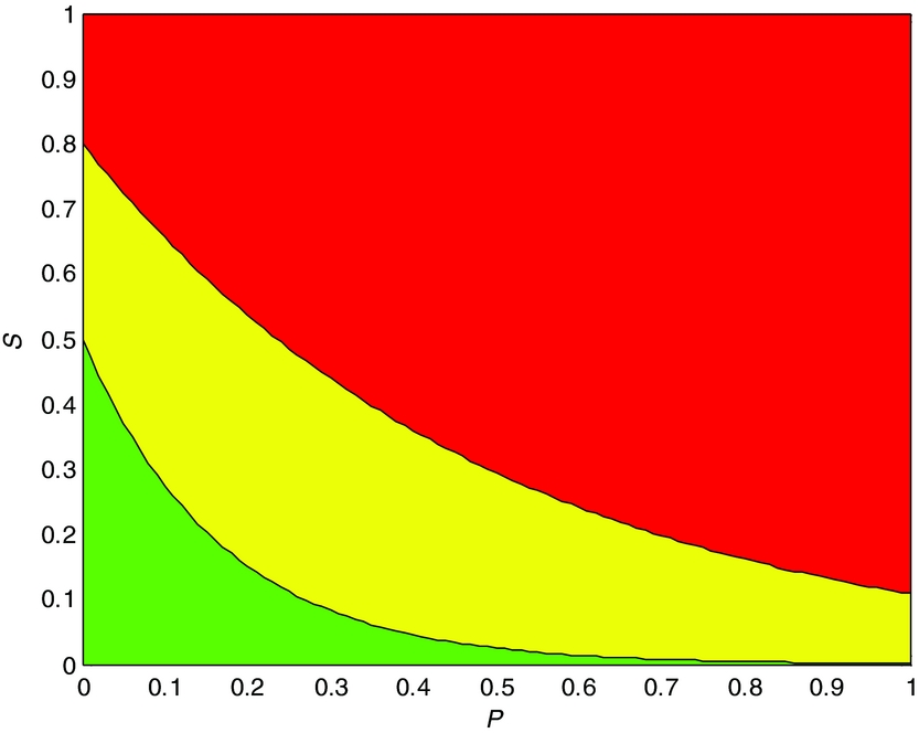
Figure 4. Bird-strike risk assessment model.
The two separation curves could be calculated using the equations:
 $$\begin{equation}
S & =& {f_1}\left( P \right) = 0.5\exp \left( { - 6P} \right)\\
\end{equation}$$
$$\begin{equation}
S & =& {f_1}\left( P \right) = 0.5\exp \left( { - 6P} \right)\\
\end{equation}$$
 $$\begin{equation}
S & =& {f_2}\left( P \right) = 0.8\exp \left( { - 2P} \right)
\end{equation}$$
$$\begin{equation}
S & =& {f_2}\left( P \right) = 0.8\exp \left( { - 2P} \right)
\end{equation}$$
Therefore, as the values of the probability and severity are set to P = p 0 and S = s 0, the risk level is determined according to
 $$\begin{equation}
R = \left\{ {\begin{array}{@{}*{1}{l}@{}} 1\qquad{{s_0} < {f_1}({p_0})}\\[6pt] 2\qquad{{f_1}({p_0}) < {s_0} < {f_2}({p_0})}\\[6pt] 3\qquad{{s_0} > {f_2}({p_0})} \end{array}} \right.
\end{equation}$$
$$\begin{equation}
R = \left\{ {\begin{array}{@{}*{1}{l}@{}} 1\qquad{{s_0} < {f_1}({p_0})}\\[6pt] 2\qquad{{f_1}({p_0}) < {s_0} < {f_2}({p_0})}\\[6pt] 3\qquad{{s_0} > {f_2}({p_0})} \end{array}} \right.
\end{equation}$$
In the previous research, the bird strike probability P could be determined by three parameters: the distance, the angle and the bird species(Reference Ning and Chen12). The value of P is constrained to the range of (0, 1).
The severity of bird strike S is estimated with a two-level model by the combination of the Delphi method and the analytic hierarchy process (AHP) method. On the first level of the hierarchy, two elements of the aircraft and birds are considered, respectively. Furthermore, on the second level, the aircraft element governs the sub-elements of the type and flight phase of aircraft, while the bird element governs the sub-elements of the number and mass of birds. Obviously, the severity value is also between 0 and 1.
4.0 INTELLIGENT DECISION-MAKING METHOD
The SVM has become a common algorithm for pattern classification in the last few years. It has gained popularity because it produces a classifier with maximum generality, can be adapted to produce non-linear classifiers, and has mitigating factors for the curse of dimensionality. In this paper, SVM is used for training the Bird-Repelling Strategy Classification Model (BRSCM). Firstly, some basic introduction of SVM is given, and then a novel mechanism is proposed for the establishment and continuous improvement of the intelligent BRSCM.
4.1 Support vector machine
SVM starts from the linear machines trained on separable data. Suppose we have some hyper-plane which separates the positive from the negative examples. Let d + (d −) be the shortest distance from the separating hyper-plane to the closest positive (negative) example(Reference Han, Kamber and Pei13). Define the ‘margin’ of a separating hyper-plane to be d + + d − . For the linearly separable case, the support vector algorithm simply looks for the separating hyper-plane with largest margin. This can be formulated as follows:
 $$\begin{equation}
{y_i}\left[ {w \cdot {x_i} + b} \right] - 1 \ge 0,\quad i = 1,2, \ldots ,n
\end{equation}$$
$$\begin{equation}
{y_i}\left[ {w \cdot {x_i} + b} \right] - 1 \ge 0,\quad i = 1,2, \ldots ,n
\end{equation}$$
Subject to Constraints (Reference Zhang4), we can find the pair of hyper-planes which gives the maximum margin by minimising ‖w‖2. For the classification problem, xi represents the given data set or vector, yi represents the classification label.
Positive Lagrange multipliers αi(i = 1, . . ., n) are introduced for Constraint (Reference Zhang4), the problem of seeking the hyper-plane has been converted into the calculating of maximum value of the function below:
 $$\begin{equation}
Q(\alpha ) = \sum_{i = 1}^n {{\alpha _i}} - \frac{1}{2}\sum_{i,j = 1}^n {{\alpha _i}{\alpha _j}{y_i}{y_j}({x_i} \cdot {x_j})} ,
\end{equation}$$
$$\begin{equation}
Q(\alpha ) = \sum_{i = 1}^n {{\alpha _i}} - \frac{1}{2}\sum_{i,j = 1}^n {{\alpha _i}{\alpha _j}{y_i}{y_j}({x_i} \cdot {x_j})} ,
\end{equation}$$
giving the conditions ∑ni = 1yiαi = 0 and w* = ∑ni = 1αi*y ixi. Consequently, the optimum classification function could be obtained:
 $$\begin{equation}
f(x) = {\mathop{\rm sgn}} \{ ({w^ * } \cdot x) + {b^ * }\} = {\mathop{\rm sgn}} \left\{ {\sum_{i = 1}^n {\alpha _i^ * {y_i}({x_i} \cdot x) + {b^ * }} } \right\}
\end{equation}$$
$$\begin{equation}
f(x) = {\mathop{\rm sgn}} \{ ({w^ * } \cdot x) + {b^ * }\} = {\mathop{\rm sgn}} \left\{ {\sum_{i = 1}^n {\alpha _i^ * {y_i}({x_i} \cdot x) + {b^ * }} } \right\}
\end{equation}$$
Those training points lying on one of the hyper-planes are called ‘support vectors’ have α*i > 0, while all others have α*i = 0.
As for the non-linear problem, we can map the data to some other infinite dimensional space by non-linear transformation. In such space, it would be hard to work with dot products on functions of the form ϕ = ϕ(xi) · ϕ(xj). Now if there was a ‘kernel function’ K(xi, xj) = ϕ(xi) · ϕ(xj), we would only use it instead in the training algorithm, needless to compute ϕ. Correspondingly, Equation (6) is converted into:
 $$\begin{equation}
f(x) = {\mathop{\rm sgn}} \left\{ {\sum_{i = 1}^n {\alpha _i^ * {y_i}K({x_i},x) + {b^ * }} } \right\}
\end{equation}$$
$$\begin{equation}
f(x) = {\mathop{\rm sgn}} \left\{ {\sum_{i = 1}^n {\alpha _i^ * {y_i}K({x_i},x) + {b^ * }} } \right\}
\end{equation}$$
Three kernels are commonly used, including polynomial function, radial basis function and sigmoid function(Reference Vapnik14,Reference Ma, Liang and Zhou15) . The traditional SVM is designed for the two-class problem, as for the n-class problem, C 2n classifiers are constructed, so the voting strategy is used for the classification.
4.2 The proposed method for airport bird-repelling
The proposed intelligent decision-making method for airport bird repellent is based on a large amount of historical avian data and the expert knowledge, using the SVM to construct the BRSCM for bird repellent. Thus, the bird repellent strategy could be given automatically against the real-time avian data, and the classification model for bird repellent strategies could be continuously improved. The decision-making flow chart is shown in Fig. 5.
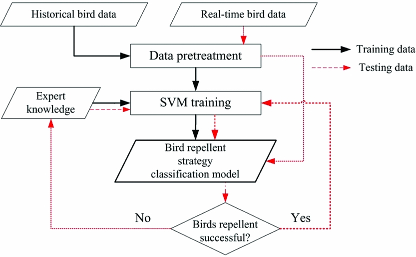
Figure 5. Flow chart of intelligent decision-making for bird repellent.
Specifically, the proposed method is composed of the following several steps:
(1) The pretreatment of the training data
The historical avian information obtained by the airport bird detection sensors is arranged as a vector whose structure is
 $$\begin{equation}
{{{\bf X}}^{{\rm{Train}}}} = \left[ {\begin{array}{*{20}{c}} D&\quad Z&\quad B&\quad N&\quad T&\quad R&{ \cdot \cdot \cdot } \end{array}} \right],
\end{equation}$$
$$\begin{equation}
{{{\bf X}}^{{\rm{Train}}}} = \left[ {\begin{array}{*{20}{c}} D&\quad Z&\quad B&\quad N&\quad T&\quad R&{ \cdot \cdot \cdot } \end{array}} \right],
\end{equation}$$
where D is the flying direction, Z is the position, B is the bird species, N is the target number, T is the period and R is the risk level.
The bird repellent strategy is determined with specific deterrents against the particular bird information. Each bird repellent strategy is represented by Y. Accordingly, each bird repellent strategy is associated with particular bird information vectors based on the expert knowledge as below
 $$\begin{eqnarray}
&&\left( {\left. {{{\bf X}}_i^{{\rm{Train}}}:Y_j^{{\rm{Train}}}} \right|\begin{array}{*{20}{c}} {i = 1,..., n;}&{j = 1,...,m} \end{array}} \right)\nonumber\\
&&\quad = {\varphi _{{\rm{knowledge}}}}\left( {\left. {{{\bf X}}_i^{{\rm{Train}}},Y_j^{{\rm{Train}}}} \right|\begin{array}{*{20}{c}} {i = 1,...\,n;}&{j = 1,...,m} \end{array}} \right),
\end{eqnarray}$$
$$\begin{eqnarray}
&&\left( {\left. {{{\bf X}}_i^{{\rm{Train}}}:Y_j^{{\rm{Train}}}} \right|\begin{array}{*{20}{c}} {i = 1,..., n;}&{j = 1,...,m} \end{array}} \right)\nonumber\\
&&\quad = {\varphi _{{\rm{knowledge}}}}\left( {\left. {{{\bf X}}_i^{{\rm{Train}}},Y_j^{{\rm{Train}}}} \right|\begin{array}{*{20}{c}} {i = 1,...\,n;}&{j = 1,...,m} \end{array}} \right),
\end{eqnarray}$$
where n bird information vectors are associated with m bird repellent strategies, and the value of n is much greater than that of m. In the training data, XTraini represents the bird information, while Y Trainj represents the bird repellent strategy.
(2) The SVM training
Based on the associated data of bird information and bird repellent strategies constructed in step 1, the SVM is used for classification model training, so the BRSCM is established as
 $$\begin{equation}
{\gamma _{{\rm{SVM}}}}{\rm{ = SVM}}\left( {\left. {{{\bf X}}_i^{{\rm{Train}}}:Y_j^{{\rm{Train}}}} \right|\begin{array}{*{20}{c}} {i = 1,...,n;}&{j = 1,...,m} \end{array}} \right),
\end{equation}$$
$$\begin{equation}
{\gamma _{{\rm{SVM}}}}{\rm{ = SVM}}\left( {\left. {{{\bf X}}_i^{{\rm{Train}}}:Y_j^{{\rm{Train}}}} \right|\begin{array}{*{20}{c}} {i = 1,...,n;}&{j = 1,...,m} \end{array}} \right),
\end{equation}$$
where γSVM is the BRSCM constructed by the SVM training, SVM represents the training process, and the value of n is much greater than that of m as well.
(3) The pretreatment of the testing data
Based on the bird information obtained by the airport bird detection devices, the bird information vector XTest is arranged following Equation (8) as the testing data.
(4) The classification of the testing data
Based on the bird repellent strategy classification model constructed in step 2, the corresponding bird repellent strategy is selected by the testing data XTest:
 $$\begin{equation}
{Y^{{\rm{Test}}}} = {\gamma _{{\rm{SVM}}}}\left( {{{{\bf X}}^{{\rm{Test}}}}} \right),
\end{equation}$$
$$\begin{equation}
{Y^{{\rm{Test}}}} = {\gamma _{{\rm{SVM}}}}\left( {{{{\bf X}}^{{\rm{Test}}}}} \right),
\end{equation}$$
where Y Test is the bird repellent strategy automatically selected by the BRSCM, and γSVM represents the BRSCM constructed by the SVM training.
(5) The modification and improvement of the BRSCM
The bird repellent work is started according to the bird repellent strategy YTest generated by step 4. In a case where the flying bird targets are driven away from the dangerous area, this new group of data should be added to the training data set to rebuild the optimised classification model
 $$\begin{equation}
\gamma _{{\rm{SVM}}}^{\rm{*}}= {\rm{SVM}}\left( {{{\bf X}}_i^{{\rm{Train}}}:Y_j^{{\rm{Train}}},\quad {{{\bf X}}^{{\rm{Test}}}}:{Y^{{\rm{Test}}}}} \right),
\end{equation}$$
$$\begin{equation}
\gamma _{{\rm{SVM}}}^{\rm{*}}= {\rm{SVM}}\left( {{{\bf X}}_i^{{\rm{Train}}}:Y_j^{{\rm{Train}}},\quad {{{\bf X}}^{{\rm{Test}}}}:{Y^{{\rm{Test}}}}} \right),
\end{equation}$$
where  $\begin{array}{*{20}{c}} {i = 1,...,n;}&{j = 1,...,m} \end{array}$, γ*SVM is the optimised BRSCM rebuilt by the SVM with the original training data as well as the newly added testing data.
On the contrary, manual intervention is required to propose the modified bird repellent strategy  ${Y^{\scriptsize\textrm{Modified}}}$ according to the bird information at present, and then the modified data is added to the training data set to rebuild the modified classification model
 $$\begin{equation}
\gamma _{{\rm{SVM}}}^{\rm{*}}= {\rm{SVM}}\left( {{{\bf X}}_i^{{\rm{Train}}}:Y_j^{{\rm{Train}}},\;{{{\bf X}}^{{\rm{Test}}}}:{Y^{{\scriptsize\textrm{Modified}}}}} \right),
\end{equation}$$
$$\begin{equation}
\gamma _{{\rm{SVM}}}^{\rm{*}}= {\rm{SVM}}\left( {{{\bf X}}_i^{{\rm{Train}}}:Y_j^{{\rm{Train}}},\;{{{\bf X}}^{{\rm{Test}}}}:{Y^{{\scriptsize\textrm{Modified}}}}} \right),
\end{equation}$$
where  $\begin{array}{*{20}{c}} {i = 1,...,n;}&{j = 1,...,m} \end{array}$. In this continuous cycle of processes, the BRSCM could be optimised constantly.
5.0 EXPERIMENTAL RESULT ANALYSIS
In this section, the processing scheme for the training and testing of BRSCM at a certain airport is given firstly, and then four bird repellent cases are described in detail.
5.1 Classification model training and testing
The 5,000 groups of historical bird information data were collected by the avian radar, infrared and visible light sensors of the bird detection system located at Beihai airport, Guangxi Province. These data are arranged in vectors according to Equation (8), where D is the flying direction with the unit vector, and Z is the position at this airport with the rectangular coordinates shown in Fig. 3. The bird species B is based on the results of the avian ecology survey around the airport, which labelled ten common bird species around the airport as Starling No. 1, Chinese Bulbul No. 2, Accipiter No. 3, Magpie No. 4, Turtle Dove No. 5, Grey-backed Shrike No. 6, Great Tit No. 7, Grey-capped Greenfinch No. 8, Small Skylark No. 9 and Swallow No. 10. The typical infrared and visible light images of these bird species are collected and stored in the bird information database of the linkage system. The kind of the detected bird target could be identified by comparison with the database.
The number N is decided by the resolution of the airport bird detection devices. The appearance time T divides 24 hours into six intervals of 0:00-5:00, 5:00-9:00, 9:00-12:00, 12:00-18:00, 18:00-20:00 and 20:00-24:00 according to the bird activity pattern around the airport, labelled with the numbers 1 to 6. For example, suppose that a flock composed of five starlings flies across the runway at 18:30, whose current position is (500, 500). The angle between the flying direction and the X axis is 30°, so the flying direction is represented by the unit vector of (0.866, 0.5). With the risk assessment method proposed in Section 3, the bird-strike risk level is R = 3. Therefore, the bird information vector is denoted by
 $$\begin{equation*}
\left[ {\begin{array}{*{20}{c}} {\left( {0.866,0.5} \right)}&{\left( {500,500} \right)}&1&5&5&3 \end{array}} \right]
\end{equation*}$$
$$\begin{equation*}
\left[ {\begin{array}{*{20}{c}} {\left( {0.866,0.5} \right)}&{\left( {500,500} \right)}&1&5&5&3 \end{array}} \right]
\end{equation*}$$
Ten kinds of bird repellent strategies are proposed by ornithologists and professional bird repellent personnel under different bird information and the existing bird repellent devices at the airport. Combined with the testing results at the airport, the strategies are associated with 5,000 groups of bird information vectors, which are shown in Table 1. For example, strategy 1 could be adopted against the bird information mentioned above; supposing that it leads to a good effect, they could be associated and denoted by
 $$\begin{equation*}
\left[ {\left( {0.866,0.5} \right)\quad \left( {500,500} \right)\quad 1\quad 5\quad 5\quad 3} \right]\quad \vdots \quad 1
\end{equation*}$$
$$\begin{equation*}
\left[ {\left( {0.866,0.5} \right)\quad \left( {500,500} \right)\quad 1\quad 5\quad 5\quad 3} \right]\quad \vdots \quad 1
\end{equation*}$$
Table 1 Bird repellent strategies associated with different groups of bird information data

To validate the proposed scheme, 50%–90% of bird information data are selected randomly from the 5,000 groups of data to train the BRSCM, while the rest of the data are used for testing. For each group of the test data, the corresponding bird repellent strategy is proposed by expert ornithologists and professional bird repellent personnel as the human-provided solution, which is taken as the standard answer in the test process. The accuracy rates of decision-making are given in Table 2. It is clear that the decision-making accuracy is higher as more training data is used. The decision-making accuracy approaches 100% when the training data rate reaches 90%. The training of the BRSCM is a process with continuous cycle and improvement. In the process of the system application, for the new bird information vector, if the decision is right, the associated data could be added to the BRSCM for training; however, in the case of a wrong decision, other strategies could be selected according to the current situations. Furthermore, if all the current strategies could not satisfy the bird repellent requirements, a new strategy should be proposed against the practical situations. Then, the new associated data are used to re-train the BRSCM, constantly improving its accuracy rate of decision-making. In the next subsection, several cases will be given to explain the process of training and testing.
Table 2 Decision-making results with different data assignments

5.2 Cases
Four cases are given on the intelligent bird repellent decision-making at Beihai airport, including the situations of different bird series, different bird repellent strategies and different treatments against right and wrong decisions.
5.2.1 Case 1: The Accipiter
One day at about 10:00, an accipiter was detected circling in the air above the western side of the runway, whose flying trajectory is shown in Fig. 6. A large bird, such as the accipiter, sometimes wheels high in the air over the airport, searching for the prey hidden in the grass, which is a serious danger for the aircrafts. The risk level R reaches 3. Therefore, some drastic measures such as the bird repellent strategy No. 3 was selected by the intelligent decision-making method, when two firecracker launchers are rotated to the bird's flying direction and started, leading to a good repellent effect. The category of bird repellent strategy and effect are described in Table 3. The system-provided solution is similar to the human-provided solution.

Figure 6. Flying trajectory map of an accipiter.
Table 3 Bird repellent strategy and effect for case 1

5.2.2 Case 2: The starlings
One evening at about 17:00, a flock of six starlings was detected flying across the northern part of the runway, whose trajectory is shown in Fig. 7. This frequently happens at dusk, when the starlings which forage during the day time inside the airport return to their nests outside the airport one after another. The risk level of these birds is relatively low, which is R = 2, so one HPAD is enough for the repellent. Therefore, bird repellent strategy No. 1 was selected by the intelligent decision-making method. The HPAD was rotated to the bird's flying direction and started, using the bird repellent sound 1, which is the sound of some kind of raptor suitable for driving away some birds. The bird repellent effect was good. Table 4 shows the category of bird repellent strategy and effect, where the human-provided solution is the same with that of the intelligent system.

Figure 7. Flying trajectory map of some starlings.
Table 4 Bird repellent strategy and effect for case 2

5.2.3 Case 3: The swallows
One evening at about 18:30, many swallows were detected flying around the southern part of the runway, whose trajectories are shown in Fig. 8. The swallow is quite a common bird species at the Beihai airport. Since it is smart enough to avoid collision with the aircrafts, the risk level is only R = 2 at most. Nevertheless, it is safer to take some repellent measures. Therefore, bird repellent strategy No. 7 was selected by the intelligent decision-making method, and the four gas cannons on the western side of the runway were started in order according to their distances to the flying bird targets. The bird repellent effect was good. Table 5 shows the category of bird repellent strategy and effect. In this case, the human-provided solution decided to start all gas cannons together, which was a little unnecessary to start that many devices.

Figure 8. Flying trajectory map of some swallows.
Table 5 Bird repellent strategy and effect for case 3

5.2.4 Case 4: the bats
One night at about 21:00, many swallows were detected flying along the runway with the trajectories of ‘Z’ as shown in Fig. 9. Subsequently, bird repellent strategy No. 7 and No. 8 were selected by the intelligent decision-making method, and the four gas cannons on the both sides of the runway were started in order, according to their distances to the targets, as shown in Table 6. However, the repellent effect was not satisfactory. Afterwards, it was analysed by the expert that the system recognition was wrong. The targets were bats, which are fond of flying in groups late in the evening. According the expert knowledge, the bats could be driven away by the ultrasonic waves which interfere with the positioning system of bats and make them uncomfortable. Thus, a new repellent strategy was added to the BRSCM, as shown in Table 6, where two bird-repelling sound devices were started with the option of ultrasonic waves.

Figure 9. Flying trajectory map of some bats.
Table 6 Bird repellent strategy and effect for case 4

6.0 CONCLUSIONS
With the development of the airport bird detection technology, the bird target information of number, species, flying detection and three-dimensional positions are obtained through the multi-source fusion of radar, infrared and visible light data. After the bird-strike risk assessment, the SVM method is used to build the BRSCM based on expert knowledge, which associates the bird information vectors with the special bird repellent strategy, realising the intelligent bird repellent decision-making. Based on the real-time bird information, the proposed BRSCM adopts the optimal combination, starting time and working mechanism of the bird repellent devices, to effectively avoid the tolerance of birds to the bird-repelling devices due to their long-term repeated operation. Meanwhile, the testing data could be utilised for the loop optimisation of BRSCM, continuously improving the bird repellent effect.
ACKNOWLEDGEMENTS
The research work is jointly funded by the National Natural Science Foundation of China (NSFC) and Civil Aviation Administration of China (CAAC) (U1633122), and supported by the National Key Research and Development Program (2016YFC0800406).