


Introduction
The extent of East Antarctic glaciation at the Last Glacial Maximum (LGM), which occurred approximately 18 000–20 000 calibrated years before present (cal yr bp), has long been a topic of conjecture. Early claims that continental ice reached the shelf break (e.g. Stuiver et al. Reference Stuiver, Denton, Hughes, Fastook, Denton and Hughes1981) have been counteracted by suggestions that ice cover was less extensive (e.g. Colhoun et al. Reference Colhoun, Mabin, Adamson and Kirk1992). Anderson et al. (Reference Anderson, Shipp, Lowe, Wellner and Mosola2002) reviewed information regarding the extent of the Antarctic Ice Sheet at the LGM, and concluded on the basis of often limited information that the grounding line of the ice sheet was in general offshore from its current position.
While this conclusion is consistent with the largely marine data considered, there is a developing body of evidence from terrestrial sources that the ice margin, at least for some areas of the East Antarctic coastline, was at or near its current position. The first conclusive evidence was provided by Burgess et al. (Reference Burgess, Spate and Shevlin1994), who reported pre-LGM radiocarbon dates on buried moss in the Larsemann Hills, suggesting that at least some of this small oasis was ice-free at the LGM (for the location of this and other places mentioned in the text, see Fig. 1). This has since been confirmed through the study of lakes in the area, in which there has been continuous sedimentation since Marine Isotope Stage 5e during the previous interglacial (Hodgson et al. Reference Hodgson, Noon, Vyverman, Bryant, Gore, Appleby, Gilmour, Verleyen, Sabbe, Jones, Ellis-Evans and Wood2001, Reference Hodgson, Verleyen, Sabbe, Squier, Keely, Leng, Saunders and Vyverman2005a, Reference Hodgson, Vyverman, Verleyen, Leavitt, Sabbe, Squier and Keely2005b, Reference Hodgson, Verleyen, Squier, Sabbe, Keely, Saunders and Vyverman2006). Hayashi & Yoshida (Reference Hayashi and Yoshida1994) deduced that ice retreat in the Lützow–Holm Bay area was prior to 30 000 yr bp, which Igarashi et al. (Reference Igarashi, Harada and Moriwaki1995) and Takada et al. (Reference Takada, Tani, Miura, Moriwaki and Nagatomo2003) extended back to the previous interglacial or perhaps earlier. Finally Gore et al. (Reference Gore, Rhodes, Augustinus, Leishman, Colhoun and Rees-Jones2001) concluded that parts of another oasis, the Bunger Hills, were also ice-free at the LGM.
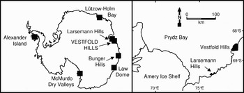
Fig. 1. Map of Antarctica showing the locations of places mentioned in the text and, in the right hand panel, a more detailed map of the Prydz Bay region showing the locations of the Vestfold and Larsemann Hills.
If these conclusions are correct, it would appear that a minimal expansion of the ice sheet (kilometre scale) occurred in the regions of these now coastal oases, rather than more extensive expansion. However, it has been suggested that another major oasis, the Vestfold Hills (located approximately 100 km from the Larsemann Hills) was entirely covered at the LGM (Adamson & Pickard Reference Adamson, Pickard and Pickard1986) by an estimated 600–700 m of ice (Zwartz et al. Reference Zwartz, Bird, Stone and Lambeck1998). The history of the Vestfold Hills has subsequently been interpreted in accordance with a thick LGM ice cover (e.g. Berkmann et al. Reference Berkman, Andrews, Bjorck, Colhoun, Emslie, Goodwin, Hall, Hart, Hirakawa, Igarashi, Ingólfsson, Lopez-Martinez, Lyons, Mabin, Quilty, Taviani and Yoshida1998, Ingólfsson et al. Reference Ingólfsson, Hjort, Berkman, Björck, Colhoun, Goodwin, Hall, Hirakawa, Melles, Möller and Prentice1998, Anderson et al. Reference Anderson, Shipp, Lowe, Wellner and Mosola2002, Ingólfsson Reference Ingólfsson, Ehlers and Gibbard2004). This model is difficult to reconcile with an ice-free Larsemann Hills, and a dissenting view was put forward by Gore & Colhoun (Reference Gore, Colhoun and Ricci1997), who argued that weathering features in some areas of the Vestfold Hills were not consistent with late Pleistocene glaciation.
In January 1995 a 23 cm sediment core was collected from Abraxas Lake in the Vestfold Hills, the base of which was radiocarbon dated to 23 200 yr bp (uncalibrated). The location of this core within the lake was not recorded, and there was also evidence of a lengthy hiatus in sedimentation (White Reference White2003). To investigate these observations further a longer sediment core was collected from the depocentre of the lake in December 2003. In this paper we discuss characteristics of this second core and provide evidence that at least part of the Vestfold Hills was not covered by a thick, erosive wet-based continental ice sheet at the LGM and was possibly ice-free. The situation in the Vestfold Hills was therefore apparently similar to that in the nearby Larsemann Hills, the Bunger Hills and ice-free areas of Lützow–Holm Bay.
Study site
Abraxas Lake is a closed, saline, meromictic lake in the Vestfold Hills, East Antarctica (68°29.34′S 78°17.22′E). The surface of the lake is 13 m above sea level, which is close to the height of the sill (13.5 m) between the lake and nearby Long Fjord (Fig. 2) (Zwartz et al. Reference Zwartz, Bird, Stone and Lambeck1998). The lake has an area of 7.7 ha, a maximum depth of 24 m, and a salinity range from 15 g l-1 to 24 g l-1 (Fig. 3, see also Gibson Reference Gibson1999). The lake water is anoxic beneath 17 m. The lake is ice covered for 11–12 months per year; melt out generally occurs in early January, but may not occur every year. Ice begins to form on the lake in late February, increasing in thickness to about 2 m by November. Water input into the lake is from melt of snow banks that develop in winter and spring in the drainage basin and from direct capture of precipitation. Water loss is through ablation and sublimation from the ice surface or evaporation when ice-free. There is no evidence of groundwater flow into or out of the lake. Water temperature varies from freezing directly under the ice in winter to near 10°C in summer (Fig. 3; see also Gibson et al. Reference Gibson, Ferris, van den Hoff and Burton1989, Gibson Reference Gibson1999). Limited nutrient data indicate that the lake is oligotrophic (Roberts & McMinn 1996a, Perriss & Laybourn-Parry Reference Perriss and Laybourn-Parry1997). It is inhabited by cyanobacteria, algae, dinoflagellates, ciliates, the agglutinated foraminiferan Paratrochammina minutissima Quilty, and three copepod species, including the calanoid Paralabidocera antarctica Thompson and two unidentified harpacticoid copepods (Burton & Hamond Reference Burton and Hamond1981, Bayly & Eslake Reference Bayly and Eslake1989, Perris & Laybourn-Parry Reference Perriss and Laybourn-Parry1997, Roberts & McMinn Reference Roberts and McMinn1999b, Gibson et al. Reference Gibson, Quilty, Swadling, Cromer and Paterson2008).
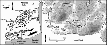
Fig. 2. Map of the Vestfold Hills, showing the locations of Abraxas Lake and other lakes mentioned in the text. Also shown is a detailed map of the Abraxas Lake region showing the topography. The contour interval is 10 m, the 10 m contour is shown by dots to show the approximate coastline at the mid-Holocene sea level maximum (Zwartz et al. Reference Zwartz, Bird, Stone and Lambeck1998).

Fig. 3. Temperature (dashed line) and salinity (solid line) profiles in Abraxas Lake, 28 October 1994. See Gibson (Reference Gibson1999) for further details.
Methods
A 142 cm piston core (UWITEC, Mondsee, Austria) was collected from the depocentre of Abraxas Lake (precise location: 68°29.356′S, 78°17.149′E) in December 2003. A shorter gravity core (29 cm) was collected from within a few metres using a UWITEC gravity corer. The piston core was sectioned in the field into 1 cm (0–86 cm) or 2 cm (86–142 cm) segments, while the gravity core was sectioned at 2 cm intervals. All segments were stored in Whirl-Pak bags at 4°C until analysis. Results from the gravity and the piston core are combined into a single 152 cm-long record. Physical and chemical data indicated that the top of the piston core was located 10 cm beneath the sediment surface.
The salinity of the sediment porewater was measured after filtration through glass wool and a 5 µm syringe filter using an Atago handheld refractometer (± 1 g l-1). Water content was determined by measuring weight loss on drying at 100°C. Loss on ignition (LOI550) was determined on dried samples by heating overnight to 550°C in a muffle furnace and reweighing. These samples were then transferred to ceramic crucibles, reweighed, and heated to 1000°C in a muffle furnace for 4 hours to decompose any CaCO3 to CaO and CO2 (LOI1000).
Equipment in the Central Science Laboratory, University of Tasmania was used to measure the δ18O of the porewater and authigenic CaCO3. The mineral form of the CaCO3 was determined by powder X-ray diffraction. Selected samples were forwarded to the Australian Nuclear Scientific and Technical Organisation for AMS 14C age determinations (Fink et al. Reference Fink, Hotchkiss, Hua, Jacobsen, Smith, Zoppi, Child, Mifsud, van der Gaast, Williams and Williams2004) of either the humic acid-free organic carbon or carbonate fractions. Humic acids were removed by initial treatment with 2 M HCl, followed by repeated washes with 0.25% or 0.5% NaOH until the solutions were clear. The samples were then finally washed again with 2 M HCl. No reservoir correction was applied, as the surface sediment from the gravity core returned a modern age. Ages were calibrated using the program Calib 5.0 (Stuiver et al. Reference Stuiver, Reimer and Reimer2005) and the Southern Hemisphere calibration set (SHCal04) of McCormac et al. (Reference McCormac, Hogg, Blackwell, Buck, Higham and Reimer2004) for ages less than 10 000 cal yr bp and a global calibration set (IntCal04: Reimer et al. Reference Reimer, Baillie, Bard, Bayliss, Beck, Bertrand, Blackwell, Buck, Burr, Cutler, Damon, Edwards, Fairbanks, Friedrich, Guilderson, Hogg, Hughen, Kromer, McCormac, Manning, Ramsey, Reimer, Remmele, Southon, Stuiver, Talamo, Taylor, van der Plicht and Weyhenmeyer2004) for ages greater than 10 000 cal yr bp.
Sediment subsamples for the determination of diatom community structure were treated with hydrogen peroxide and mounted on slides with Naphrax. Slides were viewed under a compound microscope, and the species present identified using Roberts & McMinn (Reference Roberts and McMinn1999a). Subsamples (c. 1 g) for the identification of animal remains were disaggregated in distilled water overnight, stained with Rose Bengal and passed through 200 µm, 100 µm and 44 µm mesh filters. Material retained on each of the filters was viewed under a dissecting microscope and remains identified by comparison to modern material from the lake or from similar remains observed in a previous study of lakes in the Vestfold Hills (Cromer et al. Reference Cromer, Gibson, Swadling and Ritz2005).
Water samples for analysis of major cations were collected in December 2003 at 5 m intervals throughout the water column of the lake. Analysis of the samples was performed using Inductively Coupled Plasma-Mass Spectrometry in the Central Science Laboratory, University of Tasmania.
Results
Sediment core
The sediment core from 152 cm to 122 cm consisted of grey-brown diamicton with low water content that contained poorly-sorted silt (51% on a mass basis in the bottom 7 cm of the core), sand (26%) and gravel (23%). Organic material (as indicated by LOI550) was nearly absent, and little or no CaCO3 (as indicated by LOI1000) was present (Fig. 4). Between 122 cm and 96 cm the sediment was dark grey and free from gravel, the water content increased sharply and significant amounts of organic carbon and CaCO3 were present. From 96 cm to 26 cm the sediment was diffusely-banded green-white and contained abundant organic carbon and CaCO3. From 26 cm to the surface the sediment was watery, green, and highly organic, but CaCO3 was low. There was no indication of a hiatus in sedimentation at any point of the core. The δ18OSMOW of the CaCO3, which consisted of clay to sand-sized complex intergrowths of individual aragonite crystals, was > 14‰ and typically 18–19‰ throughout. Other characteristics and implications of the organic carbon and carbonate records and full details of the isotope record will be presented elsewhere.

Fig. 4. Characteristics of the sediment core from Abraxas Lake. Selected radiocarbon ages are shown.
The porewater salinity at the base of the core was between 35 and 40 g l-1, but increased sharply from 34 g l-1 to 44 g l-1 at 130 cm (Fig. 4). For the remainder of the core the porewater salinity dropped steadily with occasional minor fluctuations. The δ18OSMOW of the porewater was between -16.4‰ and -14.1‰ throughout.
The series of radiocarbon ages obtained from the onset of significant biological sedimentation to the sediment surface provided an internally self-consistent age model for the lake (Table I & Fig. 5). The date obtained from the base of the core, 22 370 cal yr bp, is not included in this model for reasons discussed below.

Fig. 5. Radiocarbon based age model for the sediment core from Abraxas Lake. Note the generally consistent sedimentation rate between the onset of biogenic sedimentation and 3000 yr bp. As there is probably a reservoir correction of unknown magnitude for the oldest date the sedimentation model is not extended beyond the second oldest date. The approximate timing of the Last Glacial Maximum is indicated.
Table I. Full details of radiocarbon dates for 1995 and 2003 cores. All dates from the 2003 core were calibrated at the 2σ level using Calib 5.0 (McCormac 2004, Stuiver et al. Reference Stuiver, Reimer and Reimer2005) using the indicated calibration dataset. The errors quoted for all calibrated ages reflect maximum and minimum calibrated ages at the 2σ level.

Note: a. The range given is the maximum deviation of the calibrated range from the median calibrated age at the 2σ level.
Animal remains were recovered from 96 cm (sediment formed c. 10 000 cal yr bp) to the surface. The most abundant microfossils were tests of the agglutinated foraminiferan Paratrochammina minutissima, which reached densities of greater than 70 000 gdw-1 (Fig. 6). The first record of this species was in sediment deposited 9900 cal yr bp. Diatoms were present in the sediment from the same time, with the community dominated (80–100% of total diatom abundance) throughout the core by Pinnularia viridis (Nitzsch) Ehrenb. Amphora veneta Kützing, Navicula spp. and Stauroneis sp. were also present.

Fig. 6. Abundance of the foraminiferan Paratrochammina minutissima in the sediment core from Abraxas Lake. The data is plotted on a linear time scale.
Water chemistry
The relative concentrations of Na+, Mg2+ and K+ in water collected from the lake in December 2003 were very close to those expected for diluted seawater, which indicate that the salt was of marine origin (Fig. 7). It appears that no precipitation of salts of these cations through cryoconcentration of the lake's water (e.g. mirabilite, Na2SO4·10H2O; Stark et al. Reference Stark, O'Grady, Burton and Carpenter2003) has occurred. The concentration of Ca2+ was approximately half that predicted from the concentrations of the other ions as a result of Holocene (and possibly earlier) precipitation of aragonite.

Fig. 7. Concentrations (µM) of K+ (squares), Mg2+ (circles) and Ca2+ (triangles) plotted against the concentration of Na+ in water samples collected from Abraxas Lake in December 2003. Also shown are the lines expected for the dilution of seawater. The lines for K+ and Ca2+ are nearly coincident.
Discussion
The characteristics of the sediment core indicate that Abraxas Lake probably existed throughout the LGM and possibly for much longer. We draw this conclusion in particular from the salinity of the porewater, the isotopic and chemical characteristics of the sediment and lake water; and the animal and algal remains found in the core. As discussed further below, the pre-LGM 14C date from the base of the core cannot be used as direct proof of the existence of the lake prior to the LGM. The continued existence of this lake in the Pleistocene suggests that at least some of the presently ice-free Vestfold Hills was not covered by thick, wet-based glacial ice at the LGM, and may have been ice free since the end of the previous interglacial period c. 125 000 years bp. Alternatively, the Abraxas Lake area may have been covered by a thin (tens of metres) cold-based, non-erosive ice cover at the LGM. In the following paragraphs we discuss the evidence that supports these conclusions.
The radiocarbon date obtained for organic material from the base of the core, 22 370 ± 1280 cal yr bp, clearly pre-dates the peak of coastal Antarctic glaciation that occurred 20 000–18 000 yr bp (Ingólfsson Reference Ingólfsson, Ehlers and Gibbard2004), and it could therefore be concluded simply that the lake has existed since before the onset of the LGM. Consistent with this is the absence of any apparent hiatus in formation of the sediment. However, this date must be viewed with caution for a number of reasons. Radiocarbon dates from Antarctic lakes can be misleading due to the input of old carbon trapped in glaciers or permafrost, reduced gas exchange with the atmosphere due to long-term ice coverage, marine reservoir effects, presence of carbonate rocks or coal in the drainage basin; recycling of old carbon in meromictic lakes; the effects of blanketing snow and ice, and the incorporation of old carbon into sediments through reworking (Björck et al. Reference Björck, Hjort, Ingólfsson and Skog1991, Gore Reference Gore1997, Ingólfsson Reference Ingólfsson, Ehlers and Gibbard2004). For example, similar pre-LGM ages have been recorded from lake sediments from the Bunger Hills, and these ages have been interpreted to be the result of reworking of older material into more modern sediment (Melles et al. Reference Melles, Verkulich and Hermichen1994). In contrast, the original pre-LGM ages from the Larsemann Hills were obtained from terrestrial moss (Burgess et al. Reference Burgess, Spate and Shevlin1994), which would not have been affected by incorporation of old carbon. As a result of these considerations we cannot draw firm conclusions regarding the nature of Abraxas Lake at the LGM purely from the radiocarbon dates with any confidence. However, we can conclude that the lake has existed since the onset of biological sedimentation, which occurred prior to the second oldest 14C date obtained for the core, 12 860 ± 620 cal yr bp (not taking into account any late Pleistocene reservoir effect).
An important consideration in unravelling the history of Abraxas Lake is its continued salinity from the time at which the sediment at the base of the core was deposited to the present. That the lake has been saline over this period is concluded directly from the saline porewater throughout the core, most notably during deposition of the low water content sediment at the base of the core. It might be argued that post-depositional movement of salt water that entered the lake during the mid-Holocene highstand (which reached a maximum in the Vestfold Hills 6000–7000 cal yr bp; Zwartz et al. Reference Zwartz, Bird, Stone and Lambeck1998) displaced underlying freshwater within the sediment. However, water flow and diffusion of salt through the dry, stiff sediment at the base of the core would be particularly slow, and the carbonate layers higher up in the sediment would also have restricted these processes. Significant variations in porewater salinity were recorded within the core that would not be expected if significant post-depositional salt water penetration had occurred (Fig. 4).
The conclusion that the lake was saline at the onset of the Holocene (and earlier) is supported by the fauna and the flora of the lake recorded in the sediment. The dominant animal species preserved in sediments laid down soon after the onset of biological sedimentation was the foraminiferan Paratrochammina minutissima (Fig. 6), which is of marine origin (Gibson et al. Reference Gibson, Quilty, Swadling, Cromer and Paterson2008). The early Holocene sediment also contained an idiosyncratic diatom community dominated by the salt-tolerant species Pinnularia viridis, which has remained the dominant species throughout the Holocene up to the present (Roberts & McMinn Reference Roberts and McMinn1996, Reference Roberts and McMinn1999a). While this species has been recorded in other saline lakes of the Vestfold Hills, in no other lake is it the dominant species (Roberts & McMinn Reference Roberts and McMinn1999a). Many other diatom species that might be expected (by comparison to other saline lakes in the Vestfold Hills) to occur in Abraxas Lake considering its salinity were absent. Paratrochammina minutissima and Pinnularia viridis were also present in the apparently pre-LGM sediment at the base of the core collected in 1995 (White Reference White2003).
An important question that leads from these observations is: Where did Abraxas Lake obtain its salt? A general model has been developed for the origin of the numerous saline lakes in the Vestfold Hills that involves transgression of seawater into pre-existing basins as local sea level rose in the mid-Holocene (7000–6000 cal yr bp), followed by re-isolation as sea level subsequently dropped (post 6000 cal yr bp) (Zwartz et al. Reference Zwartz, Bird, Stone and Lambeck1998). Sea level rise and fall during the Holocene reflected the balance between global post-glacial, eustatic sea level increase and local isostatic rebound of the land as the mass of the Antarctic ice cap was reduced. This Holocene seawater transgression reached a maximum height of about 9–9.5 m above current sea level in the Vestfold Hills (Zwartz et al. Reference Zwartz, Bird, Stone and Lambeck1998). The sill height between Abraxas Lake and Long Fjord (Fig. 2) is 13.5 m above sea level, and therefore it would be expected that there was no Holocene input of marine water into the lake (Zwartz et al. Reference Zwartz, Bird, Stone and Lambeck1998).
This conclusion is supported by the absence of evidence of such input from the sediment core from Abraxas Lake. In particular, there was no mid-Holocene increase in diversity within the diatom and faunal communities in the sediment as a result of marine input and colonization. In contrast, the diatom communities in nearby Ace and Anderson Lakes (Fig. 2) showed marked species shift from freshwater to more complex marine-derived communities as a result of marine transgressions (Roberts & McMinn Reference Roberts, McMinn, Lyons, Howard-Williams and Hawes1997, Reference Roberts and McMinn1999b). Similarly, the fauna of Ace Lake (Fig. 2) changed dramatically when seawater entered the basin (Cromer et al. Reference Cromer, Gibson, Swadling and Ritz2005).
Further evidence is provided by the oxygen isotopic signatures of the porewater and authigenic calcium carbonate. The isotopic signatures indicate that the source of the oxygen is local precipitation rather than seawater throughout the core. The marine-derived saline lakes of the Vestfold Hills come into isotopic equilibrium with precipitation over time (Matsubaya et al. Reference Matsubaya, Sakai, Torii, Burton and Kerry1979). If seawater had entered the basin a zone of porewater and CaCO3 with higher δ18OSMOW (~0‰ and ~30‰, respectively) would be expected, reflecting the input of marine water (Bird et al. Reference Bird, Chivas, Radnell and Burton1991, Leng et al. Reference Leng, Lamb, Heaton, Marshall, Wolfe, Jones, Holmes, Arrowsmith and Leng2006).
The conclusion that can be drawn from these observations is that no marine transgression into Abraxas Lake occurred during the Holocene (consistent with the conclusions of Zwartz et al. (Reference Zwartz, Bird, Stone and Lambeck1998)), and therefore that the lake was saline from at least 10 000 cal yr bp and probably much earlier. As there are no records of marine high stands in the Vestfold Hills and other East Antarctic coastal areas between 10 000–20 000 cal yr bp (when global sea level was much lower than at present: see, for example, fig. 1 in Bentley Reference Bentley1999), it can be concluded that the clearly marine-derived salt (Fig. 7) must have entered the Abraxas Lake basin prior to the LGM, and that the lake has existed since this time. If a late Pleistocene marine transgression into Abraxas Lake had occurred it would also have resulted in nearby Ace Lake becoming saline, as the saddle separating Ace Lake from the ocean is lower than that of Abraxas Lake. However, Ace Lake was fresh from its formation > 12 000 cal yr bp up until the mid-Holocene marine transgression (Zwartz et al. Reference Zwartz, Bird, Stone and Lambeck1998, Coolen et al. Reference Coolen, Hopmans, Rijpstra, Muyzer, Schouten, Volkman and Sinninghe Damsté2004, Cromer et al. Reference Cromer, Gibson, Swadling and Ritz2005).
The highstand that resulted in marine water entering the Abraxas Lake basin may have occurred as long as ago as Marine Isotope Stage 5e, the last time that sea level was sufficiently high to enter the lake basin prior to the Holocene (Chappell & Shackleton Reference Chappell and Shackleton1986). If so, Abraxas Lake may have been in existence for over 120 000 years, as has been suggested for a series of lakes in the nearby Larsemann Hills (Hodgson et al. Reference Hodgson, Verleyen, Sabbe, Squier, Keely, Leng, Saunders and Vyverman2005a, Reference Hodgson, Vyverman, Verleyen, Leavitt, Sabbe, Squier and Keely2005b). However, it is recognized that local sea level in the Vestfold Hills is the balance between eustatic and isostatic processes, and it may be possible that sea level was higher more recently during periods of greater ice thickness on the continent and localized depression of the bedrock.
The nature of Abraxas Lake at the Last Glacial Maximum
The evidence provided above suggests that Abraxas Lake continued to exist as a body of water throughout the LGM. What is less clear is the nature of the lake at that time. However, it can be concluded that little biological productivity occurred (though sufficient organic carbon was present to allow the survival of a number of heterotrophic species), that the sediment source to the lake supplied clay, sand and gravel, and that no significant cryoconcentration of the lake water occurred. At least two scenarios are possible: i) the landscape around the lake was ice-free, but the lake itself was covered by thick ice/snow, and ii) the landscape was covered by a thin, cold-based, non-erosive ice sheet (perhaps tens of metres thick) that did not result in scouring out of the lake basin. Examples of lakes that have survived under thin glacial ice covers and retained their sediment record intact have been described from Baffin Island, Canada (Briner et al. Reference Briner, Axford, Forman, Miller and Wolfe2007) and the Larsemann Hills, Antarctica (Hodgson et al. Reference Hodgson, Verleyen, Squier, Sabbe, Keely, Saunders and Vyverman2006). If thick ice (hundreds of metres, as suggested in other studies) had been present, it would be expected that the lake water and any salt that it contained would have been forced out of the lake basin. If this had occurred, any newly formed late Pleistocene lake would have been freshwater, and not saline.
If the first scenario is correct, the ice cover prior to c. 12 500 cal yr bp must have been sufficiently thick to preclude penetration of photosynthetically active radiation (PAR) into the lake and therefore limit significant biological production within the lake. Perennial ice up to 5 m thick is present on some Antarctic lakes today that are known to harbour complex and productive ecosystems (e.g. the lakes of the McMurdo Dry Valleys). These lakes typically have extremely clear ice covers; in contrast, the ice cover on Abraxas Lake would, as a result of the salinity of the lake, have optical characteristics much more like sea ice which transmits far less solar radiation. Any snow present on the ice surface would further reduce the PAR reaching the water column (Gore Reference Gore1997). Primary productivity in the McMurdo Dry Valleys lakes also occurs in moats that form during summer; the near absence of organic carbon from this part of the sediment in Abraxas Lake suggests that moat formation did not occur, as within lake processes would be expected to transport at least some of this material to the depocentre of the lake. Limited amounts of organic material may have reached the water column as a result of within-ice productivity associated with sediment particles melting through the ice, as recorded today for lakes of the McMurdo Dry Valleys (Priscu et al. Reference Priscu, Fritsen, Adams, Giovannoni, Paerl, McKay, Doran, Gordon, Lanoil and Pinckney1998).
If Abraxas Lake was covered by permanent lake ice at the LGM, the sediment deposited at that time would in part consist of material that had blown onto the ice surface and passed through the ice as a result of preferential heating (Hendy Reference Hendy2000). Previous studies have shown that this process can lead to significant sorting due to the differential rates at which particles pass through the ice, and that the sediment in permanently ice-covered lakes typically consists of sand (Hendy Reference Hendy2000, Hendy et al. Reference Hendy, Sadler, Denton and Hall2000, Kelly et al. Reference Kelly, Denton and Hall2002). Finer particles do not travel through the ice fast enough to outstrip ablation. On consideration of the sediment fabric it is more likely that the sediment was transported to the lake in streams emanating from nearby glacial ice. A similar situation occurs at present in highly turbid lakes at the south-eastern corner of the Vestfold Hills near the confluence of the Antarctic ice cap and the Sørsdal Glacier (Fig. 2). The turbidity arising from any such stream input would have further reduced light penetration into the lake.
The water chemistry in Abraxas Lake indicates that the lake volume did not decrease markedly during the LGM, which is consistent with this scenario. If the lake was covered by a permanent ice cover, water input must have roughly balanced losses by ablation and sublimation to maintain water balance. Some meltwater input must have occurred, as direct precipitation alone would not be sufficient to maintain water level. Ice thickness also must have remained more or less constant, with new ice formation also roughly balanced by ablation losses. If the ice had become much thicker (simple calculations suggest about 10 m), salinity of the remaining water would have reached the precipitation point for mirabilite.
The second scenario, in which the lake was covered by a relatively thin, cold-based glacier, has in other instances also resulted in the formation of sandy sediments (Hodgson et al. Reference Hodgson, Verleyen, Squier, Sabbe, Keely, Saunders and Vyverman2006, Briner et al. Reference Briner, Axford, Forman, Miller and Wolfe2007). The rate of sedimentation was however much lower under glacial ice than in the Holocene, as the ice cover would be so thick that few particles would pass through it. However, it is possible that fine sediment was transported to the lake during the deglaciation phase through stream input. The thicker ice cover would preclude primary productivity, and less organic material would make it through the ice. It is also probable that most of the lake would freeze (Blake Reference Blake1989, Briner et al. Reference Briner, Axford, Forman, Miller and Wolfe2007), increasing the salinity as the volume of the remaining water was reduced. It is more likely that precipitation of mirabilite and other salts would have occurred under this scenario.
In summary, the evidence from the Abraxas Lake core suggests, but does not confirm, that the lake was not covered by glacial ice at the LGM, but rather was a covered by thick autochthonous ice cover. The main reasons for this conclusion are that the lake has apparently not gone through a stage of cryoconcentration, and that sufficient organic carbon entered or was formed in the lake to allow the continued survival of a suite of heterotrophic organisms.
Implications for ice cover in the Vestfold Hills
The continued existence of Abraxas Lake during the LGM indicates that some parts of the Vestfold Hills remained unglaciated, or at least covered by a thin, non-erosive ice sheet, at the LGM. This conclusion is at odds with the view that the Vestfold Hills was completely covered by 600–700 m ice (Adamson & Pickard Reference Adamson, Pickard and Pickard1986, Zwartz et al. Reference Zwartz, Bird, Stone and Lambeck1998) at the LGM. However, it is consistent with the model of minimal ice cover in the north-western region of the Vestfold Hills suggested by Gore & Colhoun (Reference Gore, Colhoun and Ricci1997), who argued that extensive weathering was consistent with an extended period (possibly > 70 000 yr) of subaerial exposure since the last time the area was covered by an erosive, wet-based ice sheet. How much of the Vestfold Hills was ice-free or covered by relatively thin ice at the LGM is uncertain.
Evidence now suggests that areas of many of the larger oases along the East Antarctic coastline - notably the Bunger Hills, Larsemann Hills, and Lützow–Holm Bay - were ice-free at the LGM, or at least covered by a thin, non-erosive ice sheet. The Vestfold Hills can now be added to this list. It can be concluded for these areas at least that the ice sheet did not expand far (perhaps by only kilometres) beyond the current margin, and that a minimal model of LGM ice sheet expansion is closer to the truth, at least for these regions. These conclusions are consistent with estimations of snow accumulation at Law Dome (Van Ommen et al. Reference van Ommen, Morgan and Curran2004), an isolated ice dome located near the Antarctic coastline, where accumulation since c. 15 000 yr bp has increased sevenfold, indicating that the limited LGM advance of the continental ice sheet was the result of low accumulation. However, van Ommen et al. (Reference van Ommen, Morgan and Curran2004) concluded that the seaward margin of Law Dome was 50–65 km further away from Law Dome than at present. That the continental ice cover did not expand by a similar amount near the coastal oases suggests that albedo effects may have influenced local ice dynamics, much as they do today. The situation for the oases may have been similar to that in the present-day Bunger Hills, where the exposed rock is nominally coastal, but is separated from the open ocean by the floating Shackleton Ice Shelf.
Scenarios in which the coastal oases were covered by many hundreds of metres of ice and in which the ice sheet reached out uniformly towards the continental shelf are incompatible with the growing body of terrestrially-derived evidence for the East Antarctic coastline (see also Convey et al. Reference Convey, Gibson, Hillenbrand, Hodgson, Pugh, Smellie and Stevens2008). In these coastal ice-free areas complete glaciation has clearly occurred at some time in the past, but there is no specific evidence to link this to the LGM. It is more likely that the ice that reached the continental shelf margin had its origin in the expansion of large outlet glaciers (e.g. Lambert Glacier) rather than a general expansion of the polar ice sheet.
Acknowledgements
We thank L. Newman and J. Newman for collection of cores in 2003. Ian Snape, Vin Morgan, Damian Gore and Will Howard provided useful discussion at various stages in the development of this paper. Donna Roberts assisted with diatom identification. Funding for this project was supplied by grants from the Australian Research Council (DP0342815), the Australian Antarctic Science program (AAS Grants 706 and 2387) and the Australian Institute for Nuclear Science and Engineering (Grants 04/057 and 05/063). Logistic support was provided by the Australian Antarctic Division.


