INTRODUCTION
Archaeology has a long history of seeking to compare the historical information available through oral traditions with the results of stratigraphic excavations and artifact analyses (e.g., see Pendergast and Meighan Reference Pendergast and Meighan1959; de Laguna Reference de Laguna1960). In more recent times, archaeologists have sought to investigate extant oral traditions using age ranges calculated from radiocarbon (14C) assays on excavated organic samples. José Garanger (Reference Garanger1982) conducted archaeological research in Vanuatu in the 1970s at the famed oral traditional residence and burial ground of Chief Roi Mata (now inscribed as the UNESCO World Heritage site of Chief Roi Mata’s Domain). He found that oral narratives about the site and the famed chief correlated closely with the archaeological results, which revealed an elabourate mass burial complex dating to ca. 400 years ago. Other studies in Pacific Island contexts have shown that oral traditions can complement and inform archaeological investigations, and that genealogical chronologies of the recent past can offer similar age estimates to radiocarbon (Sheppard et al. Reference Sheppard, Walter and Aswani2004; Skelly and David Reference Skelly and David2017; Kirch Reference Kirch2018). In the North American Pacific Northwest, Edinborough et al. (Reference Edinborough, Porčic, Martindale, Brown, Supernant and Ames2017) used modeled 14C dates to suggest that Indigenous Tsimshian oral traditions accurately describe demographic events (settlement relocations) that occurred between ca. 1500–1000 years ago. Yet cross-disciplinary, comparative research into the intersection of these very different ways of recording the past is in its infancy and there is a dearth of detailed case studies.
In contexts were both lines of evidence are available, combining archaeological and oral traditional information can lead to enriched understandings of how landscapes and social practices emerged, persisted, and changed. In Australia and Papua New Guinea, researchers have pursued a “dual historical method” (McNiven Reference McNiven2016: 33; see also David and McNiven Reference David and McNiven2004), through which “the repeated and particular material forms of specific cultural practices are tracked back in time archaeologically to provide the basis for interpreting the emergence and persistence of such practices through time.” In the Torres Strait Islands—located between Australia and Papua New Guinea—archaeologists have acquired 14C chronologies for dugong bone mounds, known in ethnohistory and oral tradition to be key ritual sites, showing that these installations emerged regionally from ca. 400 years ago (e.g., McNiven and Feldman Reference McNiven and Feldman2003; McNiven et al. Reference McNiven, David, Goemulgau and Fitzpatrick2009). Returning to the Pacific northwest, a recent collaboration between archaeologists and Indigenous Kwakwaka’wakw peoples established that ethnographically-known clam garden sites (rock walls built in the intertidal zone to enhance shellfish environments) were first built 11,500 years ago (Toniello et al. Reference Toniello, Lepofsky, Lertzman-Lepofsky, Salomon and Rowell2019). Studies such as these have generated historical insights inaccessible through either oral traditional or archaeological investigation alone.
The study we present here offers new insights into the historical emergence (construction) of village sites on Papua New Guinea’s south coast. One of the villages discussed in this paper (Popo) is known in oral traditions to have developed gradually through time into a village complex composed of different tribal estates (or “suburbs”). Archaeological investigation of these estates provided subtly different historical perspectives on how the village and its estates grew and changed through time. We elucidate how villages were constructed through time in the Gulf of Papua, and discuss the various limitations, potentials, and intersections of 14C and oral traditional chronologies.
Village Sites in the Gulf of Papua
The Gulf of Papua is a ca. 400-km-long area of Papua New Guinea’s south coast. The coastline comprises (west to east) the deltas of the Fly, Bamu, Turama, Kikori and Purari rivers, and is home to peoples from the Kiwai, Gogodala, Purari and Eleman language families. The area was colonised by the British in AD 1884, at which time most members of these language groups were inhabiting large coastal villages (see Chalmers Reference Chalmers1887: 235). In AD 1937, five villages in Orokolo Bay—where this study is situated—supported a total population of 4465 (Williams Reference Williams1940: 27). Large villages across the Gulf of Papua shared some elements of social, ritual, and subsistence practice, including elaborate masked ceremonies, the construction of immense longhouses, large-scale sago palm (Metroxylon sagu) starch production, and highly formalised exchange relations with distant communities (see Williams Reference Williams1924, Reference Williams1940; Knauft Reference Knauft1993). The best known of these long-distance exchanges is the hiri: an annual trade in which ceramicist Motu people from today’s Port Moresby region would exchange large quantities of pottery and shell valuables with Papuan Gulf villagers for sago palm starch and canoe hulls (see Oram Reference Oram and Dutton1982; Mennis Reference Mennis2015).
Archaeologically speaking, little is known of the emergence of these large coastal centres of social and ceremonial activity. Few archaeological research projects have taken place in the region. These projects aimed to investigate broad-scale patterns of settlement or land use (e.g., Rhoads Reference Rhoads1980; David Reference David2008; Barker et al. Reference Barker, Lamb, David, Skelly and Korokai2015), or to trace fluctuating patterns of long-distance exchange through time (e.g., Frankel et al. Reference Frankel, Thompson, Vanderwal, Frankel and Rhoads1994; Rhoads Reference Rhoads, Frankel and Rhoads1994; David et al. Reference David, Araho, Barker, Kuaso and Moffat2009). Recent research by Skelly and David (Reference Skelly and David2017; see also David et al. Reference David, Araho, Barker, Kuaso and Moffat2009) established a detailed chronology for the Kouri Lowlands region some 25 km east of Orokolo Bay (Figure 1). They showed that the alluvial and littoral sediments of this region formed rapidly, at a variable rate of between 1.8 ± 0.4 and 4.5 ± 0.9 m per year from 2700 cal BP onwards (Skelly and David Reference Skelly and David2017: 474–475; see also Thom and Wright Reference Thom, Wright and Petr1983: 7).
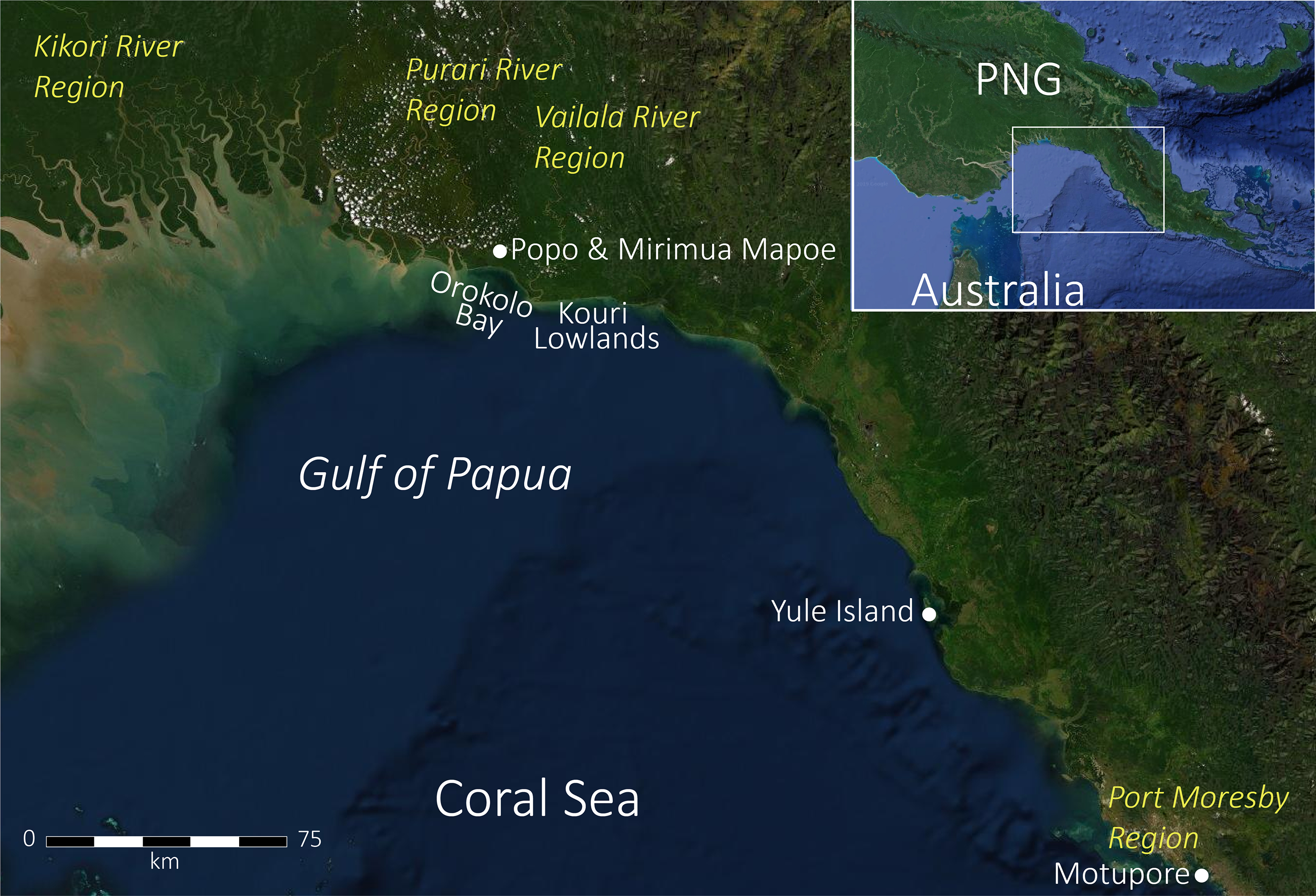
Figure 1 Gulf of Papua showing key locations and rivers mentioned in the text.
People inhabited the highly active coastline during the Holocene from ca. 2700 cal BP to ca. 1178 cal BP, when a 500-year-long hiatus in cultural material (including in-traded pottery) and radiocarbon dates is apparent until ca. 678 cal BP (Skelly and David Reference Skelly and David2017: 488–490). Skelly and David (Reference Skelly and David2017) identify several key developments after this time. In the period 678–517 cal BP, “villages are established and ceramics appear” (Skelly and David Reference Skelly and David2017: 447). Then, the period from 531 to 298 cal BP saw “increased cultural activity” in the coastal lowlands, which coincided with “the development of new social relationships with far-flung maritime traders” (Skelly and David Reference Skelly and David2017: 492). From 303 to 0 cal BP, villages in this part of the Gulf of Papua were participating in the formalised hiri trade as recorded in late 19th and 20th century ethnographies (Chalmers Reference Chalmers1887; Barton Reference Barton and Seligman1910). According to local oral traditions and written records from the colonial era, the pottery trade ceased ca. AD 1955 (see Mennis Reference Mennis2015: 194–196).
While Skelly and David’s (Reference Skelly and David2017) research has helped to establish the longue durée of occupation and exchange in this part of the Gulf of Papua, individual sites (including past villages) dating to the recent period (from 678 cal BP onwards) remain poorly understood. 14C dates acquired for this period were mostly recovered from single-zone excavations of discrete sites (Skelly and David Reference Skelly and David2017; see also David Reference David2008; Barker et al. Reference Barker, Lamb, David, Skelly and Korokai2015). More spatially expansive excavations of village sites conducted by Rhoads (Reference Rhoads1980) in the Kikori River region in the 1970s were investigated using small numbers of conventional 14C determinations, and thus lack the chronological resolution to explore village development through time. Here we contribute a fine-grained analysis of the spatial history of two village sites, investigated using a 35-date Bayesian chronology and oral traditions recorded in Orokolo Bay in 2015.
THE ORAL TRADITIONS
In 2015, we developed an ethnoarchaeological research project with the Kaivakovu and Larihairu village communities of Orokolo Bay (see Urwin Reference Urwin2019a). Based on the outcomes of whole-community meetings, a program of oral tradition interviews, surveys, and excavations was devised to investigate key past village sites. The coastal villages of Kaivakovu and Larihairu are the custodians of an ancestral migration village called Popo which is today located ca. 3.0 km inland (Figure 2; Williams Reference Williams1940: 28). Several areas within Popo are rich in surface cultural materials (e.g., shell middens and scatters of earthenware pottery sherds). Some of the southernmost zones of the site were the subject of test excavations in 1976 which yielded a single date of 410 ± 80 BP (ANU-2181), providing an age range of 554–295 cal BP at 95.4% probability using the calibration methods outlined in our Methods (Rhoads Reference Rhoads, Frankel and Rhoads1994). The village is the focal point of local migration and origin traditions (Williams Reference Williams1940: 28, Reference Williams and Schwimmer1976: 84; Urwin Reference Urwin2019b), and it features in the migration stories of people inhabiting the entire (125 km-long) geographical span of the Eleman language family (see Kakare and Karava Reference Kakare and Karava1975: 39; Skelly and David Reference Skelly and David2017: 174–175).
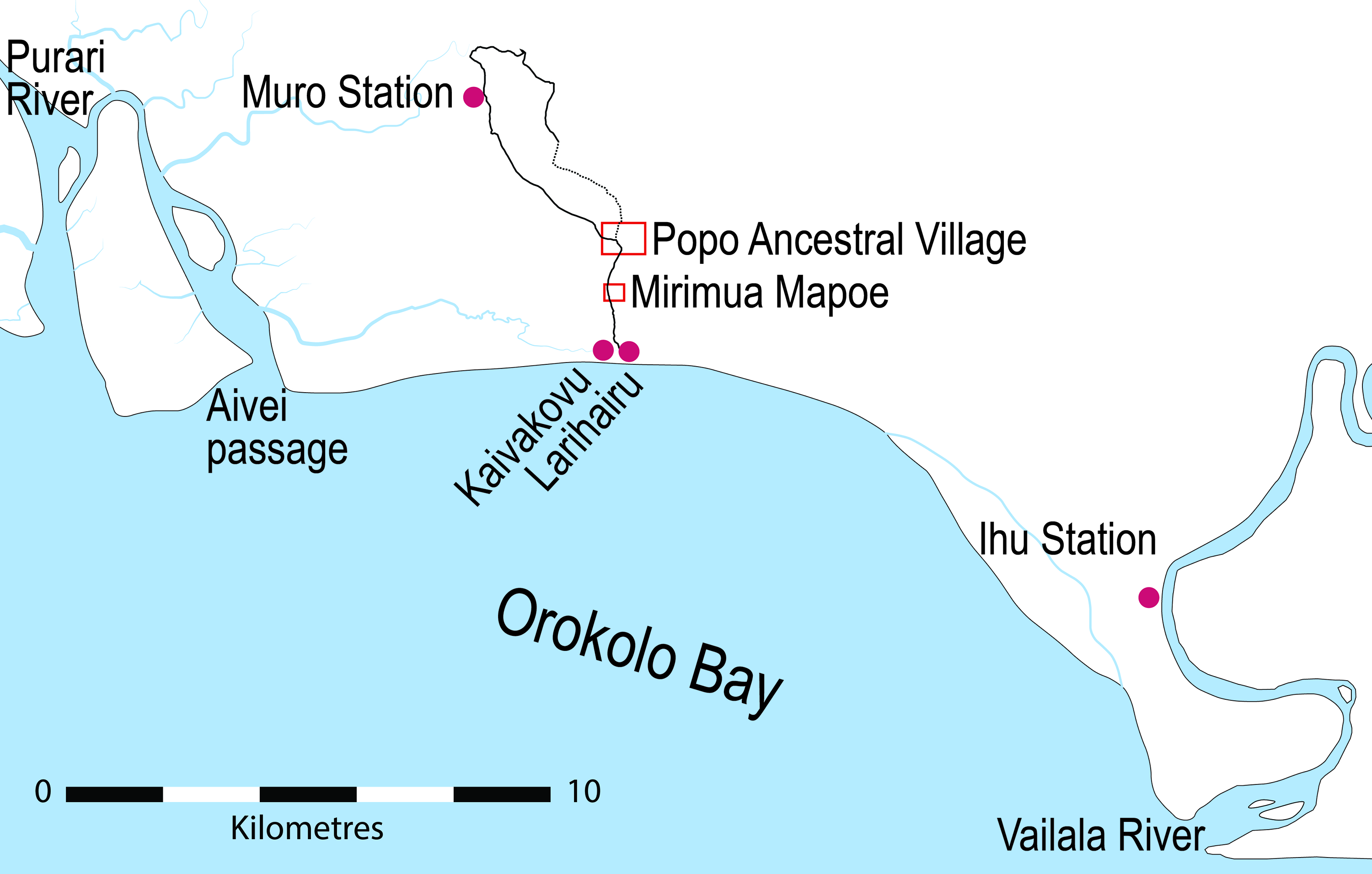
Figure 2 Locations of the Popo and Mirimua Mapoe ancestral villages. The red squares are the extent of the larger scale maps provided in Figure 5.
The members of various clans within the Kaivakovu and Larihairu villages told us (CU and HA) oral traditions about Popo. These migration traditions were told alongside genealogies comprising some 23 generations of named ancestors. Contrary to Williams (Reference Williams1940: 28; see also Rhoads Reference Rhoads, Frankel and Rhoads1994: 54), who stated that Popo was the first remembered settlement of people from the Eleman language group, the ancestral place is one of 22 past settlement locations described in local migration stories. Popo is, however, the first remembered village. In broad terms, the oral traditions describe the following events (for further details, see Urwin Reference Urwin2019b):
-
(23–17 generations ago) the ancestors of the Kaivakovu and Larihairu villages were “wandering” in tribes (social groups antecedent to modern-day clans) between temporary camp sites in northerly mountains. Seventeen of these locations are detailed in the stories, though there are some differences in the number of settlements among clan versions.
-
(16–7 generations ago) beach ridges started to form to the south of the mountains. When a large, stable beach had formed the ancestors moved down from the mountain and established the first village: Popo. The village was settled by many tribes, each of which established their own spatially separate “estate.” Each tribe named their estate and built their own eravo (longhouse). Hiri exchange with seafaring Motu traders began during the occupation of Popo.
-
(6–5 generations ago) people lived at Popo for some 11 generations. Then, a new section of beach emerged rapidly to the south. Eventually, people moved to the village of Mirimua Mapoe on the new section of beach.
In Orokolo Bay—and among other Eleman language speaking peoples—oral traditions are crucial for conveying local historicities (Williams Reference Williams1940: 28, 131–138; Brown Reference Brown1988: vi–ix). Today, locals differentiate between stories which describe the actions of ancestral “mythical beings” (lou haera), and stories about “human beings” in the recent past (e.g., descriptions of migration and village establishment). For the most part, origin stories are set in a timeless cosmological past, at a time when the lou haera formed the world and regional landscape features. Yet Eleman speakers believe the spirits of the lou haera are still present and active in the landscape today (Williams Reference Williams1940: 137–138; Urwin Reference Urwin2019b). Stories about the lou haera explain how the beaches and mountain ranges were formed, and how ceremonies (such as the famed hevehe ceremony of Orokolo Bay) and key social practices (such as long-distance sea voyaging and exchange) came about. Stories about “human beings” serve to commemorate key ancestors and explain where the ancestors came from, where and how they journeyed, and how they established the present coastal settlements of Orokolo Bay. It is worth noting that the “mythical” and “human” epochs overlap in some stories. Popo, for example, is known through genealogies and migration stories, but is also an origin site for aspects of ceremonial knowledge and material culture (Williams Reference Williams1940: 28, Reference Williams1976: 84; Kakare and Karava Reference Kakare and Karava1975: 39; Skelly and David Reference Skelly and David2017: 174–175; Urwin Reference Urwin2019b). Stories and genealogies are also of great importance in the negotiation of social group identity and land ownership in Papua New Guinea today (see Bell Reference Bell2009; Dwyer and Minnegal Reference Dwyer and Minnegal2018).
The oral traditions of Popo and Mirimua Mapoe influenced the design of our research. Popo is the archetypal Eleman migration village and the place anchors local narratives of social change (e.g., transitioning from “wandering” to a large relatively permanent settlement). Further, Popo comprised various zones (“estates”), each of which have subtly different social histories and oral traditions associated with them (see Urwin Reference Urwin2019b). As such, the place was clearly a good candidate for archaeological excavation across multiple zones, with the aim of unravelling how Papuan Gulf villages were built through time.
METHODS
To assess the spatiality and chronology of the two villages, we undertook excavations in seven named locations identified by local elders and experts in oral tradition. Six of these zones are past tribal estates of Popo (called Aitae Hiru, Koavaipi, Maivipi, Marea Ita, Miruka, and Popo Uku) and one is within the past village site of Mirimua Mapoe (Figure 2).Footnote 1 Our seven excavations targeted the densest areas of cultural materials within each zone: we aimed to acquire chronological and cultural material samples of each area. We used a Bayesian-modeled 14C chronology along with analyses of the stratigraphy and cultural material finds to analyze the phased construction of the village and to identify material relationships between different excavated areas within Popo, and between the two villages.
The archaeological samples acquired for the seven zones derive from highly controlled 1 m2 excavations, oriented north-south (Figure 2; Table 1). The excavations proceeded in ca. 2.0–3.0 cm-thick excavation units (XUs), following the contours of the stratigraphy when visible. To avoid mixing chronostratigraphic units, intrusive features were excavated as sub-XUs. We recovered all materials larger than 2.0 mm from each XU (via sieving) and acquired soil samples for each XU to facilitate pH and other soil analyses. The excavations uncovered fragments of earthenware pottery, and charcoal. All excavations except the Koavaipi excavation also contained animal bone, shell and very small (mostly flaked) stone artifacts. It is beyond the scope of this paper to describe each site, including the full excavation results. Stratigraphic descriptions are provided as Online Supplementary Tables 1–7, and detailed cultural material descriptions and analyses will be the subject of future publications (see Urwin et al. Reference Urwin, Hua, Skelly and Arifeae2018 for the Popo Uku excavation results). An example of a section drawing is presented as Figure 3. As an overview of the spatial relationships between the samples, we present the summary context details, including the site, tribal estate (if the excavation was within Popo), SU (Stratigraphic Unit) and depth of each dated sample (Tables 1 and 2).
Table 1 Summary of the cultural material finds and stratigraphy of the seven excavations.


Figure 3 Section drawing of the Miruka excavation, showing the location of the charcoal samples selected for radiocarbon dating (see Table 2).
Table 2 Radiocarbon dates acquired from the 2015 Orokolo Bay excavations.

We acquired a total of 38 AMS 14C determinations on wood charcoal. Thirty-six of the dated samples were found in situ during excavation and mapped in 3D. The two uppermost samples from the Maivipi excavation were taken from the sieved charcoal sample of XU8 (OZW433) and XU5 (OZW434) (Table 2). Short-lived sample types are preferable for Bayesian analysis (e.g., Bayliss Reference Bayliss2015), but charred seeds and well-preserved shell samples were not available in any of the seven deposits. In the tropical rainforest context of the Gulf of Papua, burned wood is taken to be evidence of burning by people. A recent review of the global literature on fire in tropical rainforests indicates that natural burning is unknown; rainforest fires “are anthropic in origin” (e.g., caused by people clearing land for agriculture) (Juárez-Orozco et al. Reference Juárez-Orozco, Siebe and Fernández y Fernández2017: 10). The wood charcoal samples could not be identified to species, due to a lack of relevant flora reference collections for tropical PNG. As such, the 14C dates presented here have unknown inbuilt ages—some or all samples may be subject to the “old wood” problem (see Schiffer Reference Schiffer1986). The assays were selected to target each identifiable SU containing cultural materials within the seven deposits (Table 2). By acquiring two or more dates from most of these SUs, we aimed to test for variations in the depositional histories within the Popo site in relation to the separate Mirimua Mapoe site. All samples were pre-treated using the standard acid-alkali-acid method (AAA) and analyzed either at the Australian Nuclear Science and Technology Organisation (ANSTO) (n = 33) (Hua et al. Reference Hua, Jacobsen, Zoppi, Lawson, Williams, Smith and McGann2001; Fink et al. Reference Fink, Hotchkis, Hua, Jacobsen, Smith, Zoppi, Child, Mifsud, van der Gaast, Williams and Williams2004) or at The Waikato Radiocarbon Dating Laboratory (University of Waikato) (n = 2).
Bayesian Model Construction
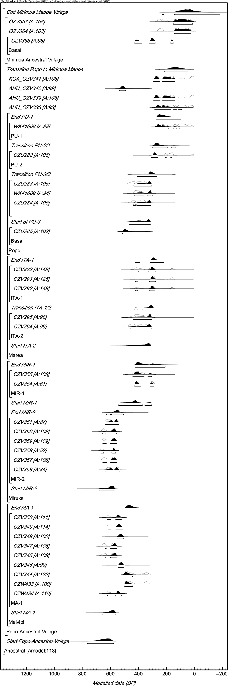
Two rounds of Bayesian modeling were undertaken. For each site with complex stratigraphy at which several samples were dated (Maivipi, Marea Ita, Miruka, and Popo Uku), we built individual site models. These preliminary models were built to account for the stratigraphic and cultural material sequence of each site and to identify formal outliers. The preliminary models are reported in detail by Urwin (Reference Urwin2019a) and the structure of each model can be seen nested within the model presented here (Figure 4; see online supplement for our OxCal code). At this stage of analysis, three of the original 38 dates were removed from the modeled population. Two of these dates were outliers (OZV454 and OZV343), occurring out of chronostratigraphic order within the respective Marea Ita and Maivipi sequences; one was a modern date from the uppermost layers of Koavaipi (OZV342), which probably originated from recent burning of the site by locals to clear it for agriculture (see Urwin Reference Urwin2019a: 235). We then built a single integrated model within which these already established (and internally consistent) chronostratigraphic units were incorporated (Tables 2 and 3; Figure 4) to examine the construction of Popo through time in relation to the later ancestral village of Mirimua Mapoe.

Figure 4 The Ancestral Village Model. Posterior density estimates are shown in solid black; individual date calibrations are shown in outline. Individual agreement indices are presented.
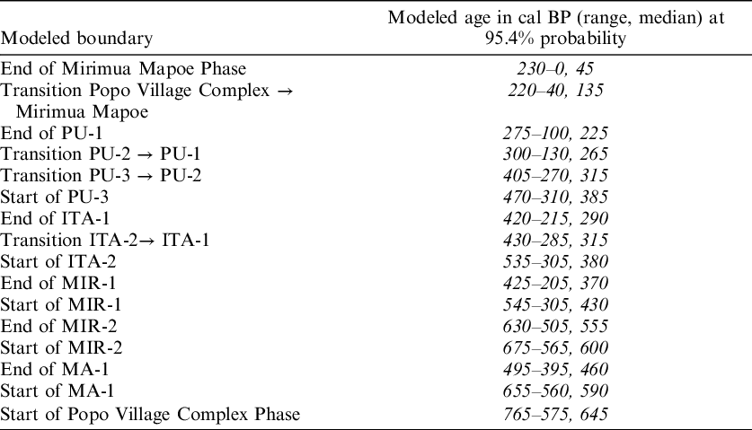
Table 3 Modeled ages for boundaries within the Ancestral Village Model, including the Chronostratigraphic Units within the Popo Ancestral Village Phase.
The chronological model was constructed using phases, boundaries and the “after” (terminus post quem) command in OxCal 4.4 (see Bronk Ramsey Reference Bronk Ramsey1995, Reference Bronk Ramsey2009; Hamilton and Krus Reference Hamilton and Krus2018: 196–198). Our model (hereafter called the Ancestral Village Model) comprises two contiguous phases called the Popo Village Complex Phase (n = 32 dates) and the Mirimua Mapoe Village Phase (n = 3 dates) (Figure 4). The assumption behind this relationship is that Mirimua Mapoe post-dates Popo. This prior information is based on local oral traditions (described above), ethnographic studies from the Gulf of Papua, and regional Holocene geomorphology. The Mirimua Mapoe site is located midway between Popo’s southernmost boundary and the present-day coastline (1.4 km north of Orokolo Bay’s beach). Both sites are located on prograded Holocene beach ridges (see Ruxton et al. Reference Ruxton, Paijmans, Bleeker and Leach1969): the ridges on which Mirimua Mapoe is situated are younger than those on which Popo is located. Ethnographic evidence from the early colonial period shows that Orokolo Bay locals progressively moved their villages south following the continually growing shoreline (Williams Reference Williams1940: 28; see also Brown Reference Brown and Franklin1973: 283; Kakare Reference Kakare1976: 69). This pattern of gradual settlement movement in relation to changing coastlines appears to be of some antiquity; it has been identified by Skelly and David (Reference Skelly and David2017: 474–475) in the Kouri Lowlands for the past ca. 2700 years cal BP. It is therefore reasonable to assume—as the oral traditional accounts explicitly state—that the occupation of Popo took place prior to that of Mirimua Mapoe.
We placed the four chronostratigraphic models already developed for the Maivipi (MA), Marea Ita (ITA), Miruka (MIR) and Popo Uku (PU) tribal estates as “overlapping” phases within the Popo Village Complex Phase (Figure 4). Overlapping phases are used to model events for which there is no prior information on how they might be ordered or related (see Bronk Ramsey Reference Bronk Ramsey2009: Figure 6). The Popo Village Complex Phase also includes four dates from two tribal estates of Popo for which no model had been previously constructed: the Aitae Hiru 1, Square A (OZV338, OZV339 and OZV340) and Koavaipi 1, Square A (OZV341) excavations. Three dates (OZV363, OZV364 and OZV365) comprise the Mirimua Mapoe Phase. The OZV365 sample—from near-basal deposits of the Mirimua Mapoe excavation—was modeled as a terminus post quem for the Mirimua Mapoe Phase. This sample originates from coarse-grained beach sands which contained a single earthenware pottery sherd and was deposited prior to village occupation at the site. Village occupation is indicated by the peak of cultural material deposition within the uppermost levels of SU2, and SU1.
The Ancestral Village Model was calculated using a form of Markov Chain Monte Carlo (MCMC) sampling to compare the modeled data with the prior information (Bronk Ramsey Reference Bronk Ramsey2009; Hamilton and Krus Reference Hamilton and Krus2018: 196–198). The model was run using the IntCal20 calibration dataset (Reimer et al. Reference Reimer, Austin, Bard, Bayliss, Blackwell, Bronk Ramsey, Butzin, Cheng, Edwards, Friedrich, Grootes, Guilderson, Hajdas, Heaton, Hogg, Hughen, Kromer, Manning, Muscheler, Palmer, Pearson, van der Plicht, Reimer, Richards, Scott, Southon, Turney, Wacker, Adolphi, Büntgen, Capano, Fahrni, Fogtmann-Schulz, Friedrich, Köhler, Kudsk, Miyake, Olsen, Reinig, Sakamoto, Sookdeo and Talamo2020). Agreement indices provide an indication of how compatible the data are with the prior information (model structure). As has been noted by various analysts, models are interpretive estimates that are subject to change each time new data are acquired (e.g., further excavations and dates) (see Bayliss et al. Reference Bayliss, Bronk Ramsey, van der Plicht and Whittle2007: 6–7; Hamilton and Krus Reference Hamilton and Krus2018). We follow Hamilton and Krus (Reference Hamilton and Krus2018: 195) in rounding modeled probabilities out to the nearest five years. Rounding improves readability and avoids giving an illusion of precision. All calibrated and modeled age ranges quoted in this paper are given at 95.4% probability.
RESULTS AND DISCUSSION
The results of the Ancestral Village Model suggest that Popo was occupied from 765–575 cal BP (median = 645 cal BP), until 220–40 cal BP (median = 135 cal BP), at which time people moved southwards to Mirimua Mapoe (Table 3). We used the OxCal “interval” command to estimate the duration of Popo’s occupation. The result indicates that Popo was occupied for a period of 675–380 years (median = 515 years). The posterior density estimates conform well to the prior information: the model has agreement indices of 112.7% (Amodel) and 111.2% (Aoverall), which are both above the acceptable threshold of 60% (Bronk Ramsey Reference Bronk Ramsey2009). The OZV358 14C date from the Miruka excavation has an agreement index of 51.7%. However, observation of the unmodeled probability distribution for this determination shows that it is broadly consistent with the posterior density estimates from the MIR-2 chronostratigraphic unit (Table 2). As such, the date need not be treated as an outlier. The Ancestral Village Model significantly constrains many of the unmodeled age ranges (and thus the chronologies for the various chronostratigraphic units). We used the “order” function of OxCal to acquire probabilistic information about the relative chronology of various events within the Popo Village Complex Phase (i.e., the modeled start, end, and transition ages for various chronostratigraphic units) (Appendix Table A.1).
The Initial Settlement Period (from 765–575 to 495–395 cal BP)
As described above, the model suggests that occupation commenced at Popo sometime within the period 765–575 cal BP. Within the Popo Village Complex Phase, the earliest modeled Chronostratigraphic Unit is that of MIR-2, occurring in the period 675–565 cal BP, followed closely by the start of MA-1 (655–560 cal BP). These depositional phases almost certainly overlap (93.8% probability: see Appendix Table A.1). MIR-2 continued to form until 630–505 cal BP. The MA-1 phase lasted longer, with a modeled duration (again calculated using the OxCal “interval” command) of 235–75 years (median = 135 years) (compared to a 125–0 year duration and 45 year median duration for MIR-2) and estimated end date of 495–395 cal BP. At the time MA-1 and MIR-2 were being deposited, the Maivipi and Miruka estates were situated close to the coast. The basal deposits underlying these layers contain water-rolled beach sands and large quantities of water-borne pumice stone. Single dates from similar deposits of near-basal sands at the Aitae Hiru (OZV340) and Popo Uku (OZU285) estates indicate that these locales (beach ridges) had just formed, and people were visiting but not living in these locations near the end of MA-1 and MIR-2 (ca. 500 cal BP) (Table 2). Aitae Hiru and Popo Uku were probably then unstable landforms within reach of flooding tides and not yet suitable for permanent settlement.
We term this period of Popo’s history the Initial Settlement Period. The deposits which accumulated at this time are suggestive of intensive village occupation at the Maivipi and Miruka estates (Figure 5A). The deposits investigated as the MA-1 and MIR-2 phases contain the remains of subsistence activities and domestic village life, such as animal bone, shell, and charcoal from fires. The two deposits also contain pottery sherds; the Maivipi excavation (MA-1) contained a vast deposit of 9885 sherds, weighing 22.4 kg. Some of the pottery sherds were decorated using techniques such as shell valve margin impressions, linear or gash incised designs, clay modeling and/or appliqué, and rows of (stick or fingernail) impressions. There are no known (past or present) pottery making traditions within the Gulf of Papua, so these items almost certainly arrived via trade or exchange. The pottery decorations and forms from the Initial Settlement Period closely resemble those found at various contemporaneous archaeological sites to the southeast in the Port Moresby region (e.g., Motupore) 290 km away, and on Yule Island (Urourina) 170 km away (Urwin Reference Urwin2019a; see also Vanderwal Reference Vanderwal1973: 112–113; Allen Reference Allen2017: 11; Skelly and David Reference Skelly and David2017: 190–193; Figure VI-12-7; Figure 1).

Figure 5 (A) the Initial Settlement Period at Popo; (B) the Village Expansion Period; (C) the Moving Estates Period; and (D) the location of the Mirimua Mapoe excavation.
The Village Expansion Period (from 545–305 to 430–285 cal BP)
Popo grew in aerial extent during the Village Expansion Period as people left the Maivipi estate and moved into the Popo Uku and Marea Ita estates (Figure 5B). As was the case for the initial occupation of Maivipi and Miruka, these movements seem to have been precipitated (in part) by the formation of stable beach ridges in these more southerly locations. Within this broad period, MIR-1 commenced at 545–305 cal BP; ITA-2 (535–305 cal BP) and PU-3 (470–310 cal BP) started shortly after (Table 3; Table A.1). This period of expanded village occupation at Popo may be contiguous with the prior Initial Settlement Period or may have occurred after a brief hiatus of activity at Popo. There is a 69.4% probability that MA-1 ended prior to the start of MIR-1. However, it is statistically possible that the MA-1 and MIR-1 phases overlapped, and there is no evidence for a depositional hiatus within the Miruka excavation (between MIR-2 and MIR-1). As there is a gap in 14C dates belonging to MIR-2 and MIR-1 (see Table 2), our interpretation is that the modeled hiatus is a product of our sampling strategy. An increased population of dates from the Maivipi and Miruka sites would help resolve this issue.
During the Village Expansion Period, pottery continued to arrive at Popo in large quantities. Pottery decorations mostly comprised stick or fingernail impressions, rows of linear or gash incisions, modeled and/or appliqué decorations. Cultural material deposition (e.g., animal bone, charcoal, pottery sherds and shell) intensified at the Miruka site during MIR-1 (compared to MIR-2). Importantly, the excavation of the ITA-2 deposits revealed several post-hole features which, according to local oral traditions, are the foundations of a traditional longhouse (eravo) building. The OZV295 sample originated from the base of one of these postholes, which suggests that the structure dates to within the period 440–305 cal BP (median = 335 cal BP).
The Moving Estates Period (from 430–285 to 220–40 cal BP)
There are two sub-phases within the Moving Estates Period at Popo. The phase commences with roughly contemporaneous transitions within the Marea Ita and Popo Uku sequences. The ITA-2 to ITA-1 transition is modeled at 430–285 cal BP and the PU-3 to PU-2 transition at 405–270 cal BP. PU-2 continues until 300–130 cal BP, and occupation ceases at ITA-1 in the period 420–215 cal BP. In this first sub-phase, intensive village occupation continues at Marea Ita from the Village Expansion Period, with a slight increase of charcoal and shell deposition. Conversely, at Popo Uku, the PU-2 phase within the Moving Estates Period represents less intensive use of this part of Popo. Compared to PU-3, there is less evidence of burning within the PU-2 deposits, and pottery remains are fewer and more fragmented. The second sub-phase primarily comprises PU-1, which ends at 275–100 cal BP (median = 225 cal BP). During this sub-phase, the Popo Uku estate sees its most intensive period of use. Three determinations from the Aitae Hiru and Koavaipi sites (OZV341, OZV338 and OZV339) fall in this period, collectively spanning 295–90 cal BP (see Table 1). Few cultural remains were found in these two excavations, which suggests that these zones were not intensively occupied or were primarily used for garden land. Further sampling of the PU-2 and PU-1 phases is required. At present, each are modeled from single radiocarbon dates.
The evidence so far demonstrates that people moved southwards across Popo during the Moving Estates Period (Figure 5C). Local oral traditions describe a time of rapid beach ridge progradation to the south of Popo some 7–6 generations ago which precipitated the move from Popo to Mirimua Mapoe. In this period, people ceased living at the more northerly estate of Miruka and focussed village occupation on the Marea Ita and Popo Uku estates. We suggest that people moved to retain the various opportunities presented by coastal village life. Pottery sherds and (shell)fish remains from the excavations are material evidence of some of these opportunities. The faunal assemblage from the Marea Ita site shows that people were acquiring marine food from reef, inter-tidal, mangrove and river subsistence zones during the Village Expansion and Moving Estates period (see Urwin Reference Urwin2019a: 157–158; Basiaco et al. Reference Basiaco, Urwin and Manne2020). By the start of the Moving Estates period the Miruka estate was at least 430 m inland and was quite distant from coastal subsistence zones. Likewise, the gradual southwards movement through Popo may have been driven by the desire to ensure village locations were accessible for coastal exchange. In regional oral traditions, past settlement locations dating to this period are sometimes also referred to as “lakatoi harbours” (Skelly and David Reference Skelly and David2017: 530–531), which suggests that villages may have been located where there were natural landing places for ceramicist traders (see Kakare Reference Kakare1976: 69).
Moving from Popo to Mirimua Mapoe (from 220–40 cal BP onwards)
Owing to the small quantity of dates, the Mirimua Mapoe Phase has an imprecise modeled duration of between 305 and 0 years (median = 80 years). People moved from Popo to Mirimua Mapoe in the period 220–40 cal BP (median = 134 cal BP), and stayed at Mirimua Mapoe until 230–0 cal BP (median = 45 cal BP) (Figure 5D). The terminus post quem date (OZV365) from basal deposits of the excavation calibrates to 430–150 cal BP (median = 305 cal BP). This date shows that beaches had already (initially) formed south of Popo towards the end of the Moving Estates Period, and that people moved into the Mirimua Mapoe location later, presumably as beach ridges in the vicinity gradually stabilised. While people were staying at this site they continued to engage in trade with pottery-producing people living on PNG’s south coast to the east. The pottery sherds found in this excavation are mostly plainware, which is consistent with ethnographic descriptions of hiri ware in the late 19th and early 20th centuries.
How the Radiocarbon Chronologies and Oral Traditions Interrelate
All forms of chronology have their own idiosyncrasies, uncertainties, and limitations. It would be naïve to suggest that oral (genealogical) and 14C chronologies are constructed for similar purposes or contain the same kind of information (see Martindale Reference Martindale2006; Bayliss et al. Reference Bayliss, Bronk Ramsey, van der Plicht and Whittle2007: 2–3 for relevant critical discussions). As described above, oral traditions in Orokolo Bay and the Gulf of Papua account for the actions of “mythical beings” in the distant, cosmological, past as well as those of recent human actors. However, cosmological stories express local forms of historicity (see Busse Reference Busse2005). Some Papuan Gulf oral traditions—especially those which relate to social interactions (e.g., exchange), ecological and landscape transformations and sequences of ancestral village locations—record events which can be observed or investigated archaeologically (see Barker et al. Reference Barker, Lamb, David, Skelly and Korokai2015; Skelly and David Reference Skelly and David2017). Taking the two villages discussed here as a case study, it appears that there is a close conformity between the radiocarbon and oral traditional chronologies for events of the recent past. Using 25 years as an approximate generation span, we can extrapolate the following genealogical chronology for the two villages. People lived at Popo within the period 16–7 generations ago (ca. AD 1600–1850, or 350–100 cal BP) and moved to live at Mirimua Mapoe from 6 to 5 generations ago (ca. AD 1850–1900, or 100–50 cal BP).
The modeled Mirimua Mapoe occupation (from 220–40 to 230–0 cal BP, or, using the median ages of the modeled boundaries, ca. 135–45 cal BP) aligns closely with the genealogical reckoning. In fact, given the fluctuations of the IntCal20 curve for the past ca. 220 years cal BP, local genealogies probably give a more precise calendrical reckoning for this recent migration and occupation. These chronologies are not entirely independent, because we used oral traditional information (in combination with ethnohistoric records and regional geomorphology) to inform our model, but the data fit the prior information well. Further to this point, the individual calibrated dates for Mirimua Mapoe (which have mean ages of ca. 110 cal BP) fit the oral traditional accounts even when unconstrained by the model. Two other modeled events have specific correlations with oral traditional accounts. First, the stories about Popo which describe the construction of a longhouse (the “first” longhouse, according to oral traditions) built at the Marea Ita estate (see Urwin Reference Urwin2019b: 290). We found seven post voids dating to 440–305 cal BP (OZV295), cut into the deepest (and oldest) deposits at Marea Ita. There is no way to ascertain whether the traces of several wooden posts are those of the “first” longhouse, but they provide a material correlate for the kind of construction described in the oral traditions about Marea Ita (see Urwin Reference Urwin2019b: 287). In the 1920s–1930s, longhouses were built 34 m long, 15 m wide and “elevated on a host of heavy piles, some 5 ft. from the ground” (Williams Reference Williams1940: 33). We can say with near certainty that a wooden structure (or structures) with densely spaced posts was installed several hundred years ago at the Marea Ita estate, at a time when Popo was expanding spatially. Second, oral narratives describe the cosmological (and geomorphological) formation of Aitae Hiru as an offshore island (Urwin Reference Urwin2019b: 291). Locals relate that their ancestors (ancestor-beings called lou haera) caused this estate to form in the sea, and then joined it to the already-formed estate of Miruka. The events identified using modeled 14C assays agree that Aitae Hiru was formed shortly after Miruka. Stories referring to this kind of geomorphological change are a regional phenomenon; Kouri Lowlands communities similarly describe how their ancestors settled “newly formed islands” (Skelly and David Reference Skelly and David2017: 98) which later became part of the mainland.
Despite these intersections, there are key differences in how the 14C and oral traditional chronologies explain Popo’s development. In the oral traditions, the estates of Popo Uku and Marea Ita were the first to be established. According to the archaeology, the Maivipi and Miruka estates formed earlier and were inhabited first, ca. 300 years earlier than the 16-generation oral chronology suggests. As such, the oral traditions seem to describe the Village Expansion and Moving Estates periods. There are several possible explanations for this. First, the oral traditions may describe the re-arrival of people following the (potential) hiatus between the Initial Settlement and Moving Estates periods. Yet there is no archaeological evidence of a hiatus at Popo (see discussion above), and the 14C hiatus is probably a product of our sampling strategy. Alternatively, the genealogical sequences of Orokolo Bay provide good chronological accuracy and precision for archaeologically observable events in the recent past, and less accuracy and precision for events which occurred after 545–305 cal BP. As Gosden and Lock (Reference Gosden and Lock1998: 5) have argued, genealogies are in one sense “a moving moment, with early kin being forgotten with the passage of time.” Skelly and David (Reference Skelly and David2017: 321, 422, 436) similarly found that calendrical estimates calculated using oral traditional and 14C chronologies were comparable for some sites dating to the past ca. 300 years or “fewer than fifteen generations” (see also Sheppard et al. Reference Sheppard, Walter and Aswani2004; Barker et al. Reference Barker, Lamb, David, Skelly and Korokai2015; Kirch Reference Kirch2018). Another possible explanation, which Urwin (Reference Urwin2019b) has explored elsewhere, is that oral traditions are partly derived from local forms of landscape knowledge, including of subsurface pottery deposits and distinctive lenses of black (iron) sands. In other words, “memories and knowledge of the past are not only passed down from generation to generation through stories but are dynamically (re)constructed and maintained in relation to the contents of the (sub)surface” (Urwin Reference Urwin2019b: 299). At Popo, the estates of Marea Ita and Popo Uku are the most extensively cleared and gardened. Because they are more intensively engaged by people today, they are thought of as especially ancient.
As we have established, oral traditions can be employed not only to help guide archaeological investigations, but also as prior information for Bayesian chronological models of ancestral places. Yet oral chronologies are not the handmaid of archaeology. While 14C dating can help elucidate “the tempo of cultural change” and “the duration of activities seen in the archaeological record” (Bayliss et al. Reference Bayliss, Bronk Ramsey, van der Plicht and Whittle2007: 2), Indigenous oral traditions concerning the actions of the ancestors encode key historical information not otherwise available to archaeologists. In the oral traditions about Popo, for example, locals insist that gaining access to long-distance maritime exchange relationships was not the primary reason for the establishment of the village at Popo (cf. Brown Reference Brown and Franklin1973: 283; Kakare Reference Kakare1976: 69–70; Skelly and David Reference Skelly and David2017: 531). Rather, people settled at Popo in various tribal estates because they desired to settle new (recently formed) land, for mutual defence, to conduct ceremonies together, and to engage in mutually beneficial sharing of subsistence tasks. Some 25 km to the east, the peoples of the Kouri Lowlands cite various reasons for settlement relocation including coastal progradation, swamplands encroaching on villages, regional land scarcity, social group fissioning, and the fertility of coastal lowland soil (e.g., Skelly and David Reference Skelly and David2017: 99). Oral traditions emphasise social, ceremonial and subsistence aspects of the history of these locations for which there are few (if any) material remains. As Kirch (Reference Kirch2018: 301) has argued for Polynesian oral traditions, “the ‘voices on the wind’ [oral traditions] and the ‘traces in the earth’ [archaeology] do not tell us the same things about the past, and it is precisely these differences that should make us want to incorporate both sources.”
CONCLUSION
The results of the excavations and Bayesian model indicate that people maintained a presence at Popo from 765–575 cal BP (median = 645 cal BP) to 220–40 cal BP (median = 135 cal BP), potentially with a short hiatus within the period ca. 460–430 cal BP. During this time, people living at Popo were acquiring pottery from seafaring communities inhabiting regions to the east such as Yule Island and Port Moresby. Probably, these pots were exchanged for locally produced sago as they were during the early colonial era (ca. AD 1880–1920) (see also Allen Reference Allen2017: 590). Combined archaeological and oral traditional information illustrates the spatial complexity of Papuan Gulf village sites and demonstrates that these places were built gradually through time. The 14C and oral traditional chronologies of Orokolo Bay agree closely for practices, places and events dating to sometime after 545–305 cal BP. Older occurrences cannot be easily or reliably traced archaeologically. The accounts diverge concerning various aspects of Popo’s historicity, due to the differing aims and ways of constructing oral traditional and archaeological knowledges. Oral traditions offer nuanced explanations of local motivations for village development, and account for rapid geomorphological changes experienced by people in their ancestral landscapes.
ACKNOWLEDGMENTS
We are grateful to the Kaivakovu and Larihairu village communities for their hospitality and support of this research. We thank the PNG National Museum and Art Gallery and the University of Papua New Guinea for logistical support in the field. Radiocarbon dating was funded through an ANSTO User Access grant (Proposal number 10726), an Australian Institute of Nuclear Science and Engineering (AINSE) Research Award (ALNGRA 16006) and an Australian Archaeological Association Student Research Grant. Bruno David and two anonymous reviewers provided helpful comments on our paper.
Supplementary material
To view supplementary material for this article, please visit https://doi.org/10.1017/RDC.2020.145
APPENDIX
Table A.1 Percentage probability that the modeled boundary (i.e., event) shown in the left-hand column occurred prior to the event shown in the top row, generated using the “order” function of OxCal 4.4.