1. INTRODUCTION
Geostationary Earth Orbit (GEO) satellites have been used in many areas such as communication, navigation and positioning, timing, tracking and scientific research because of their geostationary and high orbital characteristics (Du et al., Reference Du, Zheng, Wang and Zhang2005). GEO satellites play an increasingly important role in the space segment of the Chinese Area Navigation System (Zhou et al., Reference Zhou, Hu and Wu2010). Therefore, constructing a high-precision measuring system for GEO satellites has become a key technology.
Currently, the Unified S-Band (USB) ranging method, the L-Band pseudo-ranging method, the L-Band phase of the carrier wave measuring method and Satellite Laser Ranging (SLR) have been used to measure GEO satellites extensively. The USB ranging method is always used to control satellites, since its ranging precision is at metre level, with orbit determination precision about one hundred metres. For L-Band pseudo-ranging and phase of carrier wave measuring methods, clock synchronization between sites on the ground and satellites in the space segment are needed. Though the ranging precision of SLR can be as good as 1 cm, it is greatly affected by the weather, which means that SLR can only be an evaluation method (Lei et al., Reference Lei, Li, Yang, Wu, Cheng and Feng2011; Li et al., Reference Li, Yang, Ai, Si, Qiao and Feng2009; Song et al., Reference Song, Mao and Jia2012; Guo et al., Reference Guo, Hu, Tang, Huang, Liu, Chen and He2010a).
Unlike the former measuring methods, the C-Band transfer ranging method was proposed by the National Time Service Center (NTSC), Chinese Academy of Sciences (CAS), based on Two Way Satellite Time and Frequency Transfer (TWSTFT). The C-Band transfer ranging method has been used in the Chinese Area Positioning System (CAPS) with the advantage of separating satellite ranging from time synchronization, and being unaffected by weather.
Though CAPS has run for about eight years, most articles only give the time relationship of the signal (Li et al., Reference Li, Yang, Ai, Si, Qiao and Feng2009; Cheng et al., Reference Cheng, Li, Yang, Wu, Lei and Feng2012; Ai et al., Reference Ai, Shi, Wu, Li and Guo2009). Some articles only give the correction items, but do not give the explicit correction model (Zhou et al., Reference Zhou, Hu, Wu, Liu, Qu, Guo, He, Cao, Wu, Zhu, Shi and Tan2011; Guo et al., Reference Guo, Hu, Liu, Wu, Huang and He2010b). Thus the C-Band transfer ranging correction model with the ranging equation has never been described in detail and is introduced in this article.
Moreover, there are some ranging errors for the C-Band transfer ranging method, such as time delay measuring error, transponder delay measuring error and so on, which will affect the precision of GEO satellite orbit determination. In this article, C-Band Precise Orbit Determination (POD) precision evaluation of CAPS has been conducted using the eight years of SLR data.
POD has been achieved, using C-Band pseudo-range observation of 2010-001A in July 2012. Then POD precision is analysed by the residual Root Mean Square (RMS) of each station and orbit difference over overlaps of adjacent orbit arcs. In addition, the orbit of a GEO satellite has been evaluated by SLR data by both domestic and foreign SLR sites for the first time.
2. C-BAND TRANSFER RANGING MODEL
The time signals modulated by the pseudo code with the same carrier frequency are simultaneously dispatched to the satellite from all stations. Receivers at the stations receive the signals from all stations via the satellite transponder. There are several modes, including “receiving the own station-disseminated signals mode”, “receiving the master station-disseminated signals mode” and “receiving all station-disseminated signals mode” (Li et al., Reference Li, Yang, Ai, Si, Qiao and Feng2009; Cheng et al., Reference Cheng, Li, Yang, Wu, Lei and Feng2012). Usually, the observation of “receiving the own station-disseminated signals mode” are used to achieve POD of GEO satellite.
For the mode of receiving the own station-disseminated signals, the instantaneous observations can be expressed as (t,ρ). These can be defined as
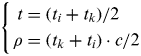 $$\left\{ \eqalign{t & = (t_i + t_k )/2 \cr \rho & = (t_k + t_i ) \cdot c/2} \right.$$
Where,
- t
is the instantaneous observation time.
- ρ
is the pseudo-range between station and satellite.
- t i
is the moment that the signal is dispatched from station.
- t k
is the moment that the signal is received at the own station from satellite transponder.
- c
is the light velocity, with unit of m/s.
If the position and velocity vector of the satellite in J2000 Inertial Coordinate System at time of t are expressed as  $\vec r$ and
  $\dot{\vec r}$ , the two vector would change to
  $\vec r_b $ and
  $\dot {\vec r_b} $ in Earth-Fixed Coordinate System, after precession transformation, nutation transformation, Greenwich sidereal time angle and polar motion transformation.
The station vector is always given at epoch 00:00 1 January 2000 in International Terrestrial Reference Frame (ITRF) 2000, then the station vector at instantaneous moment t should take the plate movement into consideration. In addition, the solid tides, ocean loading tides and Earth rotation also change station coordinates.
Since all CAPS stations are located in China, the Eurasian plate should be used (http://www.iers.org/nn_11216/IERS/EN/Publications/TechnicalNotes/tn21.html). The station coordinate change caused by solid tides can be calculated by applying the Wahr model (Li, Reference Li1995; Wahr, Reference Wahr1981). While the station coordinate change caused by ocean loading tides can be corrected by applying the Schwiderski (Reference Schwiderski1980) model and Green function (Li Reference Li1995; Melbourne et al., Reference Melbourne, Anderle, Fessiel, King, McCarthy, Smith, Tapley and Vicente1983), with the change caused by Earth rotation referring to International Earth Rotation and Reference System Service (IERS) 1996.
If the station vector at instantaneous moment t in ITRF2000 is expressed as  $\vec R_p $ after consideration of plate movement, tidal function and Earth rotation, then the geometrical distance at instantaneous moment t can be expressed as Equation (2):
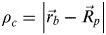 $$\rho _c = \left| {\vec r_b - \vec R_p} \right|$$
Taking the errors in propagation of C-B and transfer ranging method into consideration, the ranging corrections can be expressed as
 $$\Delta \rho = \Delta \rho _{OFC} + \Delta \rho _{DEL} + \Delta \rho _{TRO} + \Delta \rho _{ION} + \Delta \rho _{RLA} + \Delta \rho _{OFF} + \Delta \rho _{TRA} + \Delta \rho _{NOI} $$
Where,
- ∆ρ OFC
is the centre correction of station antenna phase centre.
- ∆ρ DEL
is the time delay in station instrument. For CAPS, the first 10 minutes in every hour are used to measure this time delay. In data pre-processing, this time delay can be eliminated from ranging observation.
- ∆ρ TRO
is the time delay in tropospheric propagation. This time delay can be corrected by applying the Saastamoinen Reference Saastamonien1973 model (Saastamonien, Reference Saastamonien1973) and the Niell model (Niell, Reference Niell1996), which can be used in calculating the delay in zenith and observation direction respectively.
- ∆ρ ION
is the time delay in ionospheric propagation. This time delay can be corrected by calculating the mean of the up-link and down-link ionospheric delays. The two delays should be calculated respectively, since the up-link carrier frequency is about 6 GHz, with the down-link frequency being 4 GHz (Kong et al., Reference Kong, Yang, Sun, Li and Chen2012).
- ∆ρ RLA
is the time delay due to general relativistic effect. This time delay can be corrected by applying the Shapiro Reference Shapiro1964 model (Shapiro, Reference Shapiro1964).
- ∆ρ OFF
is the centre correction of satellite transponder antenna phase centre. It is the satellite transponder but not the satellite centre of mass that receives the C-Band signal arriving at the satellite. This centre correction can be corrected by transforming the transponder antenna phase centre in Satellite-Fixed Coordinates to Topocentric Terrestrial Coordinates. Before satellite transmission, the transponder antenna phase centre vector in the system can be measured.
- ∆ρ TRA
is the transponder delay. Though it can be measured before satellite transmission, there is still some uncertainty. Therefore, the transponder delay is always treated as a parameter to be solved.
- ∆ρ NOI
is the random noise in ranging. It and the model construction errors are always treated as the system error.
From the above ranging model analysis, the C-Band transfer ranging equation can be obtained from Equations (2) and (3).
 $$\eqalign{\rho& = \rho _c + \Delta \rho \cr & = \rho _c + \Delta \rho _{OFC} + \Delta \rho _{DEL} + \Delta \rho _{TRO} + \Delta \rho _{ION} + \Delta \rho _{RLA} + \Delta \rho _{OFF} + \Delta \rho _{TRA} + \Delta \rho _{NOI}}$$
3. EXPERIMENTAL TEST
In order to evaluate the POD precision of a GEO satellite using the C-Band transfer ranging method, 2010-001A satellite was measured at the Changchun, Linton and Kashi stations of CAPS. Meanwhile, for the first time, SLR has also been used to measure the same satellite at both domestic and foreign sites such as the Changchun site, the Shanghai site and the Yarragadee site, with SLR site numbers 7237, 7821 and 7090 respectively.
The kinetic batch processing method has been applied to POD of C-Band transfer pseudo-range observation. For a GEO satellite, the dynamical perturbation models are (1) gravitational attractions of the non-spherical Earth (Earth gravity model JGM3, truncated to 10th degree and order), (2) three-body gravitational attractions of the Sun and Moon, (3) relativistic perturbation, (4) gravitational attractions of solid-Earth tides and oceanic tides, (5) radiation pressure of the Sun, (6) earthshine radiation pressure, (7) perturbation of Earth's rotational deformation and (8) empirical radial-transverse-normal accelerations (Tapley et al., Reference Tapley, Shutz and Born2004). The reference systems are (1) the mean equator (x–y plane) and mean spring equinox (the direction of the x-axis) at J2000·0, (2) ITRF2000 for the coordinates of the stations, and (3) the planetary ephemeris DE403/LE403 (Song et al., Reference Song, Mao and Jia2012). The adopted astronomical constants, reference system, dynamical and measurement models are referred to IERS 1996.
The residual RMS of each station in POD are analysed including orbit difference over overlaps of adjacent orbit arcs. In addition, the orbit of GEO satellite has been evaluated by SLR data by both domestic and foreign SLR sites for the first time.
3.1. Residuals RMS in POD of GEO Satellite
The orbit determination slip arc has been chosen as 1·5 days, shifting about one day every time. And the strategy for POD is as follows. The sets of parameters, including six sets for satellite orbit parameters, six sets for solar radiation coefficient, six sets for experimental acceleration, and six sets for transponder delay, are estimated. Moreover, the sum of bias of each station is restricted to zero.
The residual RMS calculation of station i can be completed using Equation (5).
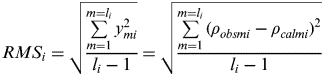 $$RMS_i = \sqrt {\displaystyle{{\sum\limits_{m = 1}^{m = l_i} {y_{mi} ^2}} \over {l_i - 1}}} = \sqrt {\displaystyle{{\sum\limits_{m = 1}^{m = l_i} {(\rho _{obsmi} - \rho _{calmi} )^2}} \over {l_i - 1}}} $$
Where, m is from 1 to l i, with l i being the number of observation of station i.
y mi is the residual of the m item of station i. ρ obsmi is the observation range of the m item of station i. ρ calmi is the calculated range of the m item of station i.
The residuals RMS of all stations can be calculated using Equation (6).
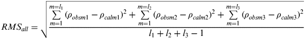 $$RMS_{all} = \sqrt {\displaystyle{{\sum\limits_{m = 1}^{m = l_1} {(\rho _{obsm1} - \rho _{calm1} )^2} + \sum\limits_{m = 1}^{m = l_2} {(\rho _{obsm2} - \rho _{calm2} )^2} + \sum\limits_{m = 1}^{m = l_3} {(\rho _{obsm3} - \rho _{calm3} )^2}} \over {l_1 + l_2 + l_3 - 1}}} $$
Where, l 1, l2 and l 3 are the observation number of station Changchun, Linton and Kashi respectively.
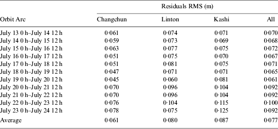
Table 1 shows the residuals RMS of Changchun, Linton and Kashi stations of CAPS from 13 to 24 July 2012. Figure 1 gives the residuals of the first three orbit arcs.

Figure 1. Residuals of stations in CAPS of orbit arc from 13 July to noon of 16 July 2012.
Table 1. Residual RMS of stations in CAPS for different orbit arcs.
From Table 1, the average of residual RMS of POD using C-Band observation is about 0·077 m. Therefore, the satellite orbit determined can reflect the C-Band observation very well.
The Kashi station antenna angle of observing 2010-001A satellite is not high. Moreover, the observation data is not consecutive for Linton and Changchun stations on some days, as Figure 1 shows. All would affect the residuals of these three stations.
3.2. Orbit difference in overlap of adjacent arcs
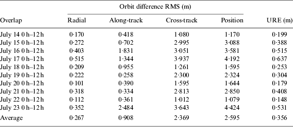
The POD precision can be estimated by the orbit overlaps of adjacent arcs. Each two adjacent arcs have an orbit overlap of half a day. The orbit difference in radial, along-track and cross-track direction, with User Range Error (URE) (Zhou et al., Reference Zhou, Hu and Wu2010) are both analysed. Table 2 gives the orbit difference RMS in radial, along-track, cross-track direction and URE in overlaps of two adjacent arcs. Figure 3 shows the orbit difference of the first three overlaps.
Table 2. Orbit difference RMS and URE in overlaps of adjacent arcs.
From Table 2 and Figure 2, the orbit difference RMS is better than 0·3 m for radial direction, 0·908 m for along-track direction and 2·369 m for cross-track direction. The average position RMS is about 2·595 m, with URE being 0·356 m.
Figure 2. Orbit difference in overlaps at 14 July to noon of 16 July 2012.
3.3. Evaluation of POD using SLR data
Domestic and foreign SLR sites observed the same GEO satellite simultaneously with CAPS in July 2012. The line-of-sight residuals of SLR sites can be obtained from the orbit determined using C-Band transfer data and SLR data. Table 3 depicts the SLR data volume and residuals RMS of the SLR sites. The residuals of SLR sites on 13 July 2012 are shown in Figure 3.
Figure 3. Residuals of SLR site 7237 and 7090 on 13 July 2012.
Table 3. SLR data volume and residual RMS analysis in July 2012.
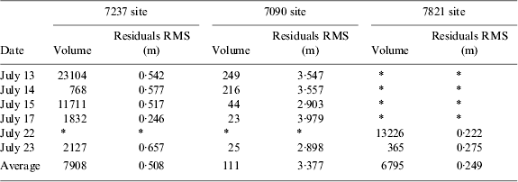
The average of residual RMS of 7237 site is about 0·508 m. Meanwhile, the value for 7821 site is about 0·249 m. RMSs for both domestic SLR sites are better than 1 m. Therefore, the orbit determined using C-Band transfer observation can satisfy users' need in the Chinese area.
However, the average of residual RMS for the foreign SLR site 7090 is about 3·4 m, which is about 3 m larger than that for the domestic SLR sites. This may be caused by the distribution of the CAPS stations. Since all of the CAPS stations are located in China, the orbit determined using C-Band transfer observation would lean to the northern hemisphere.
From the residual RMS analysis, the distribution of CAPS stations affects POD precision. The orbit determined using CAPS observations lean to the northern hemisphere, which makes residual RMS for domestic SLR sites less than those for the SLR site in Australia.
4. DISCUSSION AND CONCLUSION
The C-Band transfer ranging correction models have been described in detail for the first time in this article. Then POD of a GEO satellite has been conducted using C-Band transfer ranging observation. Finally, the POD precision has been evaluated in three aspects.
The residual RMS of CAPS stations and orbit difference in overlaps of adjacent arcs in POD of GEO satellite are measured in the first place. The GEO satellite orbit can accord with the C-Band observation very well, with residual RMS for CAPS stations being better than 0·1 m. Meanwhile, orbit difference in overlaps of adjacent arcs is better than 3 m using only three CAPS stations, with URE being better than 0·5 m.
In addition, POD precision of CAPS has been evaluated from residual analysis by SLR data from both domestic and foreign SLR sites for the first time. The residual RMS of the SLR site in the southern hemisphere is larger than that of the sites in China. Residual RMS in line-of-sight for SLR sites in China are better than 1 m, while the RMS for the Yarragadee site in Australia is about 3·4 m.
The distribution of CAPS stations does affect the orbit precision. All sites in CAPS are now located in China with low and medium latitudes. The suggestion that C-Band transfer stations should be widely located all over the world would improve the POD precision. Also, more SLR observations from SLR sites in other latitudes and other areas are needed to evaluate the POD precision in future.
Since satellite orbit and satellite clock bias are highly coupled, they typically need to be determined together to be consistent. However, using C-Band ranging observation, only the satellite orbit can be determined. If the satellite clock bias needs to be calculated, other measuring methods, like the L-Band pseudo-ranging method (Guo et al., Reference Guo, Hu, Tang, Huang, Liu, Chen and He2010a), can be combined in POD.
ACKNOWLEDGEMENT
The SLR observation was carried out by Changchun and Shanghai SLR sites in China and Yarragadee site in Australia. All SLR data can be downloaded from http://ilrs.gsfc.nasa.gov/products_formats_procedures/fullrate/fr_format_v3.html.
This work was carried out under the support of the National Natural Science Foundation (Grant No. 11033004, No. 11173026 and No. 41104021) and West Light Foundation of the Chinese Academy of Sciences (Grant No. 2007LH01).