

Across the UK and the rest of Europe, recognition of the importance of shallow groundwater in the urban environment is increasing, driven by the need to protect water supplies and by environmental legislative and policy developments – in particular, the EU Water Framework Directive (CEC 2000) – and growing interest in sustainable urban drainage schemes. Many European cities use urban aquifers for water supply (e.g., cities in Russia, Germany, Slovenia and the UK; Wolf et al. Reference Wolf, Held, Klinger and Hötzl2006), and although these are typically deeper aquifers, the potential impact of overlying shallow groundwater on deeper groundwater resource use is significant. However, the Water Framework Directive broadened the scope of groundwater management by highlighting the significance, and requiring the protection, of small, local and/or low-productivity aquifers, and of groundwater that is not necessarily currently used as an abstractive resource (SEPA 2007; UK TAG 2011). Urban groundwater can provide a wide range of ecosystem services in cities, including: maintaining healthy urban river flows; supporting surface water ecosystems and habitats; attenuating some pollutants; mitigating the impacts of extreme rainfall events, including surface flooding, through sustainable drainage systems; and acting as a thermal resource for heating and cooling (e.g., in the USA, Kaufman et al. Reference Kaufman, Rogers and Murray2011; in Germany, Kessler et al. Reference Kessler, Terrington, Sobisch, Gunnink, Ludwig, Harms, Turner and Moore2010; Lundy & Wade Reference Lundy and Wade2011; in Australia, Mitchell Reference Mitchell2006; in London, Birks et al. Reference Birks, Whittall, Savill, Younger and Parkin2013; and in Cardiff, Farr et al. Reference Farr, Patton, Boon, James, Williams and Schofield2017). Urban groundwater can also be a threat – for example, as a source and/or pathway of contamination to surface waters (e.g., in Birmingham, Lerner Reference Lerner2003; Shepherd et al. Reference Shepherd, Ellis and Rivett2006; and in Glasgow, Wade et al. Reference Wade, Lundy, Fordyce, Berwick, Jeffries, Lass-Evans, Ó Dochartaigh and Garcia-Haba2013), or through groundwater flooding at the ground surface or within underground assets (e.g., in Oxford, Macdonald et al. 2012b; and in London, Boni et al. Reference Boni, Cigna, Bricker, Meisina and McCormack2016). Urbanisation initially tends to increase recharge to urban aquifers, with reductions in natural rainfall recharge compensated by leakage from water mains and/or wastewater returns via leaking sewers (e.g., in Hong Kong, Munich and Merida, Mexico; Lerner Reference Lerner1997). However, in post-industrial cities, there can be a net reduction in recharge resulting from changing ground conditions, drainage patterns and leakage rates. Urbanisation also typically increases contaminant loading of aquifers (Foster & Vairavamoorthy Reference Foster and Vairavamoorthy2013).
Urban surface and subsurface conditions are inherently heterogeneous, such that the urban water environment is extensively altered compared to its pre-urbanised state. Urban alterations can significantly impact on groundwater systems (Marsalek et al. Reference Marsalek, Cisneros, Karamouz, Malmquist, Goldenfum and Chocat2008; e.g., as demonstrated for London by Bricker et al. Reference Bricker, Banks, Galik, Tapete and Jones2017), including: extensive areas of impermeable surface sealing; below-ground construction that can impact on recharge and groundwater flows; artificial ground, which can be a barrier or a preferential route for recharge, discharge and contamination, and/or a contaminant source; engineered drainage; enhanced recharge from leakage of imported water from outside city boundaries (in water mains and/or sewers); reduced recharge where sewers ‘drain' groundwater; areas of relatively ‘natural' recharge in open parkland and gardens; and contamination from a wide range of sources (e.g., as demonstrated for Brighton, Liverpool, Birmingham and London in the UK by Lerner & Barratt Reference Lerner and Barrett1996; for cities worldwide in Lerner Reference Lerner2003; for cities in Europe, Australia, the USA and Africa by Drangert & Cronin Reference Drangert and Cronin2004; and for Bucharest, Romania, by Boukhemacha et al. Reference Boukhemacha, Gogu, Serpescu, Gaitanaru and Bica2015). In the UK, complexity in the urban built environment is often matched by complex bedrock and Quaternary geology. This is the case in Glasgow, as with many other industrial cities overlying extensively mined Carboniferous rocks in central Scotland, the N and Midlands of England, and S Wales. Groundwater systems below urban areas are typically significantly more hydrogeologically complex than rural systems (Schirmer et al. Reference Schirmer, Leschik and Musolff2013). Understanding the complexity of shallow urban groundwater systems and their interaction with surface water and land is critical if we are to better benefit and manage any threats from urban groundwater (Howard Reference Howard, Howard and Israfilov2002; Shepherd et al. Reference Shepherd, Ellis and Rivett2006; Wolf et al. Reference Wolf, Held, Klinger and Hötzl2006).
This paper illustrates how conceptual understanding of a shallow urban groundwater system can be improved in a city where shallow groundwater is not widely abstracted and, consequently, relatively little groundwater data are available. We describe the hydrogeology of the Quaternary aquifer system beneath Glasgow, drawing on the results of projects carried out by the British Geological Survey (BGS) as part of the Clyde Urban Super Project (CUSP) between 2004 and 2015. This work was driven by Glasgow City Council's commitment to ensuring that the city's physical and chemical water environment is not adversely impacted by development, and to incorporating an effective understanding of the subsurface, including groundwater, in planning for effective and sustainable urban regeneration and development (Glasgow City Council 2015). Within CUSP, the studies that have most contributed to improving hydrogeological understanding in Glasgow are as follows: the development of numerical three-dimensional (3D) geological models of Quaternary sediments (Monaghan et al. Reference Monaghan, Arkley, Whitbread and McCormac2014; Kearsey et al. Reference Kearsey, Williams, Finlayson, Williamson, Dobbs, Marchant, Kingdon and Campbell2015, Reference Kearsey, Whitbread, Arkley, Finlayson, Monaghan, McLean, Terrington, Callaghan, Millward and Campbell2018); collating and interpreting available groundwater data and piloting a monitoring network for shallow groundwater heads in E Glasgow (Bonsor et al. Reference Bonsor, Bricker, Ó Dochartaigh and Lawrie2010); the development of a tool to assess threats to shallow groundwater from soil pollutants (Fordyce et al. Reference Fordyce, Ó Dochartaigh, Bonsor, Ander, Graham, McCuaig and Lovatt2018); improving the management of subsurface data (Bonsor et al. Reference Bonsor, Entwisle, Watson, Lawrie, Bricker, Campbell, Lawrence, Barron, Hall and Ó Dochartaigh2013); collating and using geotechnical data to model Quaternary hydraulic conductivity (Williams et al. Reference Williams, Dobbs, Kingdon, Lark, Williamson, MacDonald and Ó Dochartaigh2018); and developing a simple groundwater flow model for the Quaternary aquifer system, used to test conceptual hydrogeological understanding (Turner et al. Reference Turner, Mansour, Dearden, Ó Dochartaigh and Hughes2014).
Glasgow is Scotland's largest city and former primary industrial centre, covering an area of approximately 400km2 on the Clyde estuary in W–central Scotland, at the NW extent of the 3100km2 River Clyde catchment (Fig. 1). Glasgow has a legacy of industrially polluted land and of coal and other mineral mining, and is currently undergoing extensive regeneration and development. Upstream from the city, the Clyde catchment is predominantly rural and upland, with land use dominated by moorland, grassland and arable farming, and extensive commercial forestry in some areas. The city has a temperate maritime climate with an average precipitation of 1100mmyear–1 and potential evaporation rates in the order of 500mmyear–1 (Turner et al. Reference Turner, Mansour, Dearden, Ó Dochartaigh and Hughes2014). Within Glasgow, a number of open or partially culverted tributaries drain into the River Clyde.
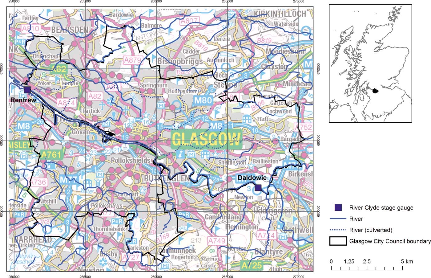
Figure 1 Main map: location of Glasgow; Glasgow City Council boundary, major rivers and location of River Clyde stage gauges referred to in text. Inset: Glasgow City Council boundary (black) and River Clyde catchment (grey). Contains Ordnance Survey data, including British National grid (m) © Crown Copyright and Database Rights 2016.
In the 19th and early 20th Centuries, groundwater, abstracted largely from Carboniferous bedrock aquifers in and around Glasgow, was widely used in industries that included distilling, brewing and other food and drink manufacture, dye works, iron works, sawmills, chemical manufacture, printing, shipbuilding and laundries (Ó Dochartaigh et al. Reference Ó Dochartaigh, Smedley, MacDonald, Darling and Homoncik2011). Extensive groundwater abstraction also occurred from coal-bearing Carboniferous rocks during mine dewatering operations, with an estimated total abstraction at peak dewatering activity of approximately 215,000m3day–1 (Ó Dochartaigh et al. Reference Ó Dochartaigh, Graham and MacDonald2007). As industrial activity declined during the 20th Century, so did groundwater abstraction, and by the early 21st Century there were only a handful of groundwater abstraction boreholes within the city boundary, all from bedrock.
Groundwater from the Quaternary aquifer system in Glasgow has not historically been widely abstracted. The availability of abundant, if often highly mineralised, groundwater in bedrock aquifers below the city, which was later replaced by surface water sources outside the city, combined with actual and/or perceived poor shallow urban groundwater quality, means there has been little investigation of Quaternary groundwater in Glasgow. Prior to the CUSP, research in the 1990s highlighted shallow groundwater contamination in parts of eastern Glasgow, historically one of its most intensively industrial areas, particularly related to chromium contamination (Whalley et al. Reference Whalley, Hursthouse, Rowlatt, Iqbal-Zahid, Vaughan and Durant1998; Farmer et al. Reference Farmer, Thomas, Graham, Geelhoed, Lumsdon and Paterson2002). Since then, few dedicated groundwater studies have been undertaken of the Quaternary aquifer system in Glasgow. A pilot groundwater monitoring network, implemented as part of the CUSP project, allowed the collection of new groundwater head data for the Quaternary aquifer system in parts of E Glasgow (Bonsor et al. Reference Bonsor, Bricker, Ó Dochartaigh and Lawrie2010), and an investigation of chromium attenuation in the hyporheic zone of a stream in SE Glasgow provided new groundwater chemistry data for a small area (Palumbo-Roe et al. Reference Palumbo-Roe, Banks, Bonsor, Hamilton and Watts2017). However, many subsurface site investigations, some extensive, have been carried out for the purposes of land regeneration, particularly in E Glasgow. These private sector investigations typically include the collection of targeted groundwater data, in particular contaminant groundwater chemistry, sometimes groundwater heads and, less commonly, hydraulic conductivity. However, the data are rarely used beyond the immediate purposes of the site development project, and are not generally in the public domain (Bonsor et al. Reference Bonsor, Entwisle, Watson, Lawrie, Bricker, Campbell, Lawrence, Barron, Hall and Ó Dochartaigh2013). Glasgow City Council has also carried out some groundwater head monitoring adjacent to the River Clyde. As part of CUSP, these groundwater data have been collated and used to help develop an improved conceptual model of the shallow Quaternary groundwater system in Glasgow.
1. Geology
Glasgow's geology is typical of many other UK cities in central Scotland, the N and Midlands of England, and S Wales, and of many cities outside the UK that overlie coal-bearing rocks. A heterogeneous, complex and often thick sequence of unconsolidated Quaternary deposits overlies Carboniferous bedrock, which is often coal-bearing and was extensively mined in the 19th and 20th centuries.
1.1. Bedrock geology
The bedrock geology in Glasgow is dominated by Carboniferous sedimentary rocks, dominantly the Clackmannan and the Scottish Coal Measures groups (Fig. 2) of Upper Carboniferous age. The older Clackmannan Group comprises the Limestone Coal, Upper Limestone, Lower Limestone and Passage formations. The younger Coal Measures are subdivided into Lower, Middle and Upper. These consist primarily of cyclical fluvial, deltaic and marine sedimentary sequences of sandstones, mudstones, limestones, coals and ironstones in varying proportions. Limestone, ironstone and coal seams within the sequence are typically thin, often less than 1m, but sandstone and mudstone beds are often tens of metres thick. The Passage Formation is the only unit in the sequence that is not coal-bearing. The Clackmannan Group beneath Glasgow ranges from 670 to 830m in thickness, and the Coal Measures Group is 360m thick (Hall et al. Reference Hall, Browne and Forsyth1998). There is a long history of coal mining from Carboniferous sedimentary rocks in Glasgow and the surrounding region. Scottish coal production, almost entirely in the Central Belt of Scotland, peaked in 1913 at approximately 44 million tonnes annually (Younger Reference Younger2001). Coal mining in Glasgow began over 300 years ago, and ended with the closure of the last colliery in the city in 1966 (Hall et al. Reference Hall, Browne and Forsyth1998). The Limestone Coal Formation was the principal source of coal in Glasgow, but coal seams in other formations have also been extensively mined, particularly the Middle and Lower Coal Measures and the Upper Limestone Formation (Hall et al. Reference Hall, Browne and Forsyth1998).
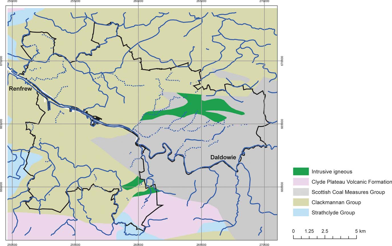
Figure 2 Simplified bedrock geology of Glasgow. Geological Data (DigMap625), BGS © NERC. Contains Ordnance Survey data © Crown Copyright and Database Rights, 2016. Other legend as Figure 1.
Basaltic-felsic lava flows of the Clyde Plateau Volcanic Formation, produced during large-scale volcanism in the Lower Carboniferous, form high ground to the S and N of the city (Fig. 2). The volcanic rocks occur in discrete, largely fault-bounded blocks within the dominantly sedimentary sequence (Hall et al. Reference Hall, Browne and Forsyth1998). Intrusive igneous rocks of late Carboniferous and early Permian age also crop out in Glasgow (Fig. 2), mostly taking the form of doleritic sills and dykes (Hall et al. Reference Hall, Browne and Forsyth1998; Browne et al. Reference Browne, Dean, Hall, McAdam, Monro and Chisholm1999).
1.2. Quaternary geology
Quaternary deposits in Glasgow comprise a complex, heterogeneous sequence of glacial and postglacial sediments with diverse depositional histories. BGS developed a detailed 3D model of the Quaternary geology across the whole of Glasgow, which includes 21 distinct lithostratigraphic units, including anthropogenic deposits, which is described in Monaghan et al. (Reference Monaghan, Arkley, Whitbread and McCormac2014) and Kearsey et al. (Reference Kearsey, Whitbread, Arkley, Finlayson, Monaghan, McLean, Terrington, Callaghan, Millward and Campbell2018). The model was developed in GSI3D™, a 3D geological framework modelling methodology that uses information from borehole geological logs and captures geologists' conceptualisations of geological structure (Kessler & Mathers Reference Kessler and Mathers2004). A subsequent stochastic geological model was developed to investigate the lithological variability of the Quaternary sequence in central Glasgow (Kearsey et al. Reference Kearsey, Williams, Finlayson, Williamson, Dobbs, Marchant, Kingdon and Campbell2015), using GOCAD® modelling software and information from geotechnical borehole logs.
A simplified 2D map output from the 3D model shows the surface outcrop of key Quaternary units, and their subsurface expression is illustrated in cross sections (Fig. 3). They are described in the following and summarised in Table 1.

Figure 3 (a) Simplified surface Quaternary geology map of Glasgow showing key hydrogeological units and lines of cross sections in Figure 4. Geology exported from 3D geological model (Monaghan et al. Reference Monaghan, Arkley, Whitbread and McCormac2014). Geological Data, BGS © NERC. Contains Ordnance Survey data © Crown Copyright and Database Rights, 2016. Other legend as Figure 1. (b) Lithostratigraphic cross sections along the lines shown on the map, extracted from 3D Quaternary geological model (Monaghan et al. Reference Monaghan, Arkley, Whitbread and McCormac2014). Made ground = artificial ground.
Table 1 Stratigraphic table showing the main Quaternary geological sequence in Glasgow (after Monaghan et al. Reference Monaghan, Arkley, Whitbread and McCormac2014; Kearsey et al. Reference Kearsey, Williams, Finlayson, Williamson, Dobbs, Marchant, Kingdon and Campbell2015). Note, the most significant geological units in terms of groundwater flow and storage in the Clyde valley in Glasgow are highlighted in bold.

The most laterally extensive Quaternary deposit across Glasgow is the glacial till of the Wilderness Till Formation, which crops out at the ground surface across much of the city (Fig. 3), and rests on bedrock across much of the area (Kearsey et al. Reference Kearsey, Williams, Finlayson, Williamson, Dobbs, Marchant, Kingdon and Campbell2015; Monaghan et al. Reference Monaghan, Arkley, Whitbread and McCormac2014). It is typically less than 5m thick, but can be thicker in drumlins, and becomes thinner and sometimes absent on higher ground (Fig. 3; Table 1; Monaghan et al. Reference Monaghan, Arkley, Whitbread and McCormac2014; Kearsey et al. Reference Kearsey, Williams, Finlayson, Williamson, Dobbs, Marchant, Kingdon and Campbell2015).
In the central part of the Clyde valley in Glasgow, along the lower reaches of the present course of the River Clyde, the Wilderness Till Formation is overlain by a sequence of postglacial sand, gravel, silt and clay deposits, of (glacio) marine, estuarine, deltaic and alluvial origin (Table 1; Fig. 3). These include a number of geological units of different thickness and composition, the oldest of which is the Bridgeton Sand Member and the youngest the Law Sand and Gravel Member (Fig. 3; Table 1). The total thickness of these deposits in the centre of the Clyde valley commonly exceeds 30m (Browne & McMillan Reference Browne and McMillan1989; Monaghan et al. Reference Monaghan, Arkley, Whitbread and McCormac2014; Kearsey et al. Reference Kearsey, Williams, Finlayson, Williamson, Dobbs, Marchant, Kingdon and Campbell2015). The geological units are typically highly heterogeneous, reflecting the wide variety and intrinsic heterogeneity of depositional environments. For example, Browne & McMillan (Reference Browne and McMillan1989) describe the depositional environment of the Bridgeton Sand Member as a glaciomarine delta, where highly heterogeneous glacial meltwater flows entered the sea and were subject to marine currents, resulting in a fining-up succession of sands and silts with discrete palaeochannels and multiple scales and types of sedimentary bedding structures; and infer post-depositional evolution slumping, folding and faulting at micro to metre scale. A similar degree of heterogeneity occurs in other geological units in Glasgow, including the Gourock Sand and Paisley Clay members (Browne & McMillan Reference Browne and McMillan1989).
In common with all historical urban areas, there are extensive anthropogenic deposits across Glasgow. These are highly variable in origin, nature and thickness, and include all types of artificial (made) ground, including worked, infilled, landscaped and disturbed ground. Excavated voids include clay or sand extraction quarries or pits and shallow mine workings, many of which have subsequently been filled in with waste from mining (coal, ironstone and other minerals), refining (including chemical waste, particularly from chromite ore processing), manufacturing (including cement, iron and steel and chemicals) and construction. Artificial ground in Glasgow is generally less than 2.5m thick, but in the most industrialised areas it frequently measures up to 10m thick, and, less frequently, more than 20m thick (Monaghan et al. Reference Monaghan, Arkley, Whitbread and McCormac2014).
2. Bedrock hydrogeology
Little information is available on the hydrogeology of Carboniferous sedimentary bedrock aquifers in Glasgow, or of hydraulic connectivity and interaction between them and the overlying Quaternary aquifer system. Hydrogeological data, such as aquifer properties, groundwater heads or groundwater chemistry, were not routinely recorded during the period of peak groundwater abstraction from these aquifers in the 19th and early 20th Centuries. Available local groundwater data from this period are largely restricted to occasional one-off records of borehole yield and, even more rarely, groundwater heads and limited chemical analyses.
Data from beyond Glasgow, across central Scotland, show that similar extensively mined Carboniferous sedimentary formations typically form moderate productivity, multi-layered aquifers, in which sandstones act as discrete aquifer units, separated by lower permeability siltstones, mudstones and unmined coals (Ó Dochartaigh et al. Reference Ó Dochartaigh, Smedley, MacDonald, Darling and Homoncik2011, Reference Ó Dochartaigh, Diaz Doce, Rutter and MacDonald2015a, Reference Ó Dochartaigh, MacDonald, FitzSimons and Wardb). Faults have been shown to subdivide the Carboniferous sedimentary aquifer in some areas: some faults are permeable, and can act as preferential flow pathways; others act as barriers to groundwater flow (Ó Dochartaigh et al. Reference Ó Dochartaigh, MacDonald, FitzSimons and Ward2015b). The impacts of mining – both where mine voids remain open and where they have subsequently collapsed, causing increased fracturing – tend to increase, often dramatically, the permeability and, to a lesser degree, the storage capacity of the Carboniferous aquifer, both in and immediately adjacent to mining activities (Ó Dochartaigh et al. Reference Ó Dochartaigh, MacDonald, FitzSimons and Ward2015b).
The limited available data for Glasgow itself indicate that the city may have been a focus for the discharge of groundwater flowing through Carboniferous rocks from the E, NE and SE (Hall et al. Reference Hall, Browne and Forsyth1998; Robins Reference Robins1990). The natural chemistry of groundwater in the Carboniferous aquifer in Glasgow has been reported as typically moderately to highly mineralised, with abundant iron and manganese in solution (Hall et al. Reference Hall, Browne and Forsyth1998; Ball Reference Ball1999), and mining impacts are thought to have led to significant deterioration in groundwater quality (Hall et al. Reference Hall, Browne and Forsyth1998). Data from a small number of new groundwater boreholes drilled in Glasgow since the mid-20th Century indicate typical yields from unmined strata of less than 1ls–1, with a handful of boreholes providing higher yields of up to 9ls–1 (Hall et al. Reference Hall, Browne and Forsyth1998). Confined conditions can occur in sandstone units in Carboniferous aquifers and can lead to artesian water heads – naturally overflowing at the ground surface – and a small number of artesian boreholes were recorded historically in the Coal Measures and Clackmannan groups in Glasgow.
3. Results of investigations into Quaternary hydrogeology
3.1. Aquifer structure and hydraulic properties
The new 3D geological models developed by BGS (Fig. 3) allow detailed visualisation of the complex Quaternary sediments below Glasgow and support the interpretation of their likely aquifer hydraulic properties, including lateral and vertical variations in hydraulic conductivity, and hydraulic connectivity between different units. The most accurate way to characterise aquifer hydraulic conductivity is through in situ testing (Williams et al. Reference Williams, Dobbs, Kingdon, Lark, Williamson, MacDonald and Ó Dochartaigh2018). However, it is expensive to collect such data, and it is particularly difficult to collect enough data for effective characterisation in Quaternary deposits because of their intrinsic heterogeneity, the more so in urban areas where the subsurface has been extensively altered (Schirmer et al. Reference Schirmer, Leschik and Musolff2013; Bricker & Bloomfield Reference Bricker and Bloomfield2014; Williams et al. Reference Williams, Dobbs, Kingdon, Lark, Williamson, MacDonald and Ó Dochartaigh2018). Limited in situ hydraulic conductivity field test data for Glasgow, previously collected during land-regeneration site investigations carried out by private sector organisations, were available through the BGS National Geotechnical Properties Database, measured by falling head, packer and constant head tests (Fig. 4a). Between five and 17 individual hydraulic conductivity values are available for each of the four most widespread Quaternary units in Glasgow: the Gourock Sand, Paisley Clay and Bridgeton Sand members and the Wilderness Till Formation (Table 1).

Figure 4 (a, b) Range of hydraulic conductivity values (mday–1) for the four most common Quaternary geological formations in Glasgow. Box plots show minimum, Q25, median, Q75 and maximum values for each formation; number of samples shown in brackets. (a) Measured values from the BGS National Geotechnical Properties Database. (b) Derived values from Williams et al. (Reference Williams, Dobbs, Kingdon, Lark, Williamson, MacDonald and Ó Dochartaigh2018). (c) Lithological variability (proportion of coarse- and fine-grained sediment) in the most common Quaternary geological formation in Glasgow (after Turner et al. Reference Turner, Mansour, Dearden, Ó Dochartaigh and Hughes2014).
To supplement this limited dataset, we sourced two supporting proxy datasets for hydraulic conductivity for Quaternary deposits in Glasgow. The first is a series of hydraulic conductivity values derived from particle size and relative density data by Williams et al. (Reference Williams, Dobbs, Kingdon, Lark, Williamson, MacDonald and Ó Dochartaigh2018; Fig. 4b). The relationship between particle size and hydraulic conductivity is well documented (MacDonald et al. Reference MacDonald, Maurice, Dobbs, Reeves and Auton2012a; Bricker & Bloomfield Reference Bricker and Bloomfield2014; Williams et al. Reference Williams, Dobbs, Kingdon, Lark, Williamson, MacDonald and Ó Dochartaigh2018), as are the limitations of the various formulae and methodologies available for estimating hydraulic conductivity from particle size (Bricker & Bloomfield Reference Bricker and Bloomfield2014; Williams et al. Reference Williams, Dobbs, Kingdon, Lark, Williamson, MacDonald and Ó Dochartaigh2018). The formula used to derive the hydraulic conductivity values in this dataset was developed by MacDonald et al. (Reference MacDonald, Maurice, Dobbs, Reeves and Auton2012a) for highly heterogeneous superficial deposits, and is well suited to urban environments because it uses standard geotechnical parameters that are near-ubiquitous in urban investigations (Williams et al. Reference Williams, Dobbs, Kingdon, Lark, Williamson, MacDonald and Ó Dochartaigh2018).
The second supporting dataset is a qualitative assessment of aquifer permeability based on lithology, which assumes that the higher the proportion of sand and gravel in a unit, the higher its overall permeability will be, and vice versa (e.g., Lewis et al. Reference Lewis, Cheney and Ó Dochartaigh2006). The proportion of (i) coarse-grained (sand and gravel) and (ii) fine-grained (silt and clay) deposits in each geological unit was calculated from lithological analysis of the large number of available borehole logs for central Glasgow (Turner et al. Reference Turner, Mansour, Dearden, Ó Dochartaigh and Hughes2014; Fig. 4c). More detailed lithological analysis was done on data from the same borehole logs by Kearsey et al. (Reference Kearsey, Williams, Finlayson, Williamson, Dobbs, Marchant, Kingdon and Campbell2015), with comparable results.
The Gourock Sand Member has the highest median measured (0.84mday–1) and derived (1.03mday–1) hydraulic conductivity values (Fig. 4a, b). Lithological analysis supports this, indicating that the unit is dominated by sand and gravel deposits.
Only six measured hydraulic conductivity values are available for the Bridgeton Sand Member, all of which are for silty fine-grained sand horizons. The measured median value (0.12mday–1) is low, comparable to the Paisley Clay Member, but the range in measured values indicates a skew towards higher hydraulic conductivity values (Fig. 4a). There are significantly more derived than measured hydraulic conductivity values, and these indicate higher values (median 0.54mday–1; Fig. 4b). Lithological analysis indicates the unit overall is dominated by coarse-grained deposits (Fig. 4c), so the measured hydraulic conductivity values may not be representative. Differences in hydraulic conductivity between units may not be wholly controlled by lithology but, for example, by local differences in depositional history. However, this evidence suggests that the overall hydraulic conductivity of the Bridgeton Sand Member may be similar to that of the Gourock Sand Member, although the observed presence of horizons with lower hydraulic conductivity means anisotropy is likely to be higher.
More (17) measured hydraulic conductivity values are available for the Paisley Clay Member. This has the lowest median measured for hydraulic conductivity (0.068mday–1), but the largest range in values (1.36E–5–164.2mday–1; Fig. 4a). The derived values show a similar pattern (Fig. 4b). Lithological analysis indicates the unit is dominated by fine-grained deposits (Fig. 4c), which is at odds with the number of higher hydraulic conductivity values reported. However, stochastic lithological modelling indicates that the Paisley Clay Member contains a significant proportion of sand (Kearsey et al. Reference Kearsey, Williams, Finlayson, Williamson, Dobbs, Marchant, Kingdon and Campbell2015), which is supported by the number of relatively high derived hydraulic conductivity values. It may be that there are frequent, possibly thin, sand-dominated horizons, which can influence the local permeability of the unit, but which are not recorded in the borehole logs selected for lithological analysis. This probable interbedding of fine- and coarse-grained lenses or layers means that the Paisley Clay Member may exhibit significantly more anisotropy in hydraulic conductivity than the other two aquifer units.
Only five measured hydraulic conductivity values are available for the Wilderness Till Formation, and they are similar to the significantly larger dataset of calculated values, indicating low average values (Fig. 4a, b). Lithological analysis indicates the unit is dominated by fine-grained deposits (Fig. 4c).
3.2. Groundwater heads
Time-series groundwater head (level) data were collated from 20 monitoring boreholes in the Quaternary aquifer system in Glasgow along a 7-km-long stretch of the River Clyde (Fig. 5). Data were measured by automatic pressure transducer, corrected for atmospheric pressure variations. Most of the boreholes lie in a series of transects sited from 20 to 290m, and more or less perpendicularly away from the river (Fig. 5, inset). Five are upstream and the others are downstream of the nominal tidal limit of the River Clyde (defined for navigation purposes on the river; Fig. 5; Table 2). The aquifer unit monitored by each borehole was identified by comparing borehole lithology with the recorded position of the borehole screen (the open portion of the borehole). Sixteen of the boreholes monitor the Gourock Sand and/or the Bridgeton Sand Member, either alone or where the two aquifer units are in direct contact (not separated by the intervening Paisley Clay Member), and four of the boreholes monitor the Paisley Clay Member (Table 2).
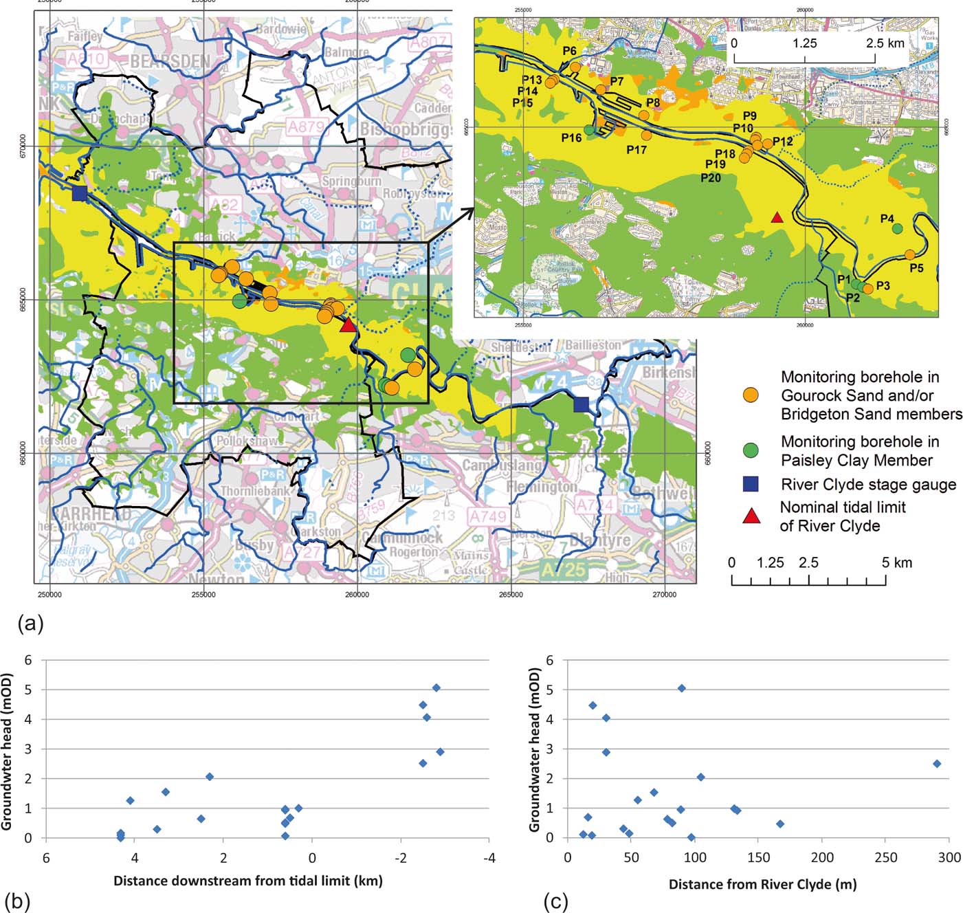
Figure 5 (a) Map showing location of groundwater monitoring boreholes in the three main Quaternary hydrogeological units in Glasgow (artificial ground not shown; other geology legend as Fig. 3). Inset: zoomed-in view of monitoring boreholes, labelled as in Table 2. (b) Dry period (minimum) groundwater heads plotted against distance downstream from the tidal limit. (c) Dry period (minimum) groundwater heads plotted with distance away from River Clyde.
Table 2 Summary of groundwater head and river-level monitoring stations in Glasgow. In the boreholes highlighted in bold, the monitored aquifer unit is likely to be confined (groundwater head is in an overlying unit). The screen length varies between boreholes, but each borehole is only screened adjacent to the specified monitored aquifer unit. Abbreviations: GUF = Gourock Sand Member; BRON = Bridgeton Sand Member; PAIS = Paisley Clay Member.

1Boreholes P7–P20 not monitored continuously during these periods.
2River Clyde stage data monitored and kindly provided by Scottish Environment Protection Agency.
The monitoring period in each borehole ranged from 15 to 34 months. The monitoring frequency was 15-min intervals in most cases, but occasionally 5-min intervals. Fifteen boreholes downstream of the River Clyde tidal limit were monitored for between 15 and 34 months in 2003–2006, although none were monitored continuously throughout this time (Fig. 6; Table 2). Five boreholes, upstream of the tidal limit, were monitored continuously for between 16 and 24 months in 2011–2013 (Fig. 7; Table 2).
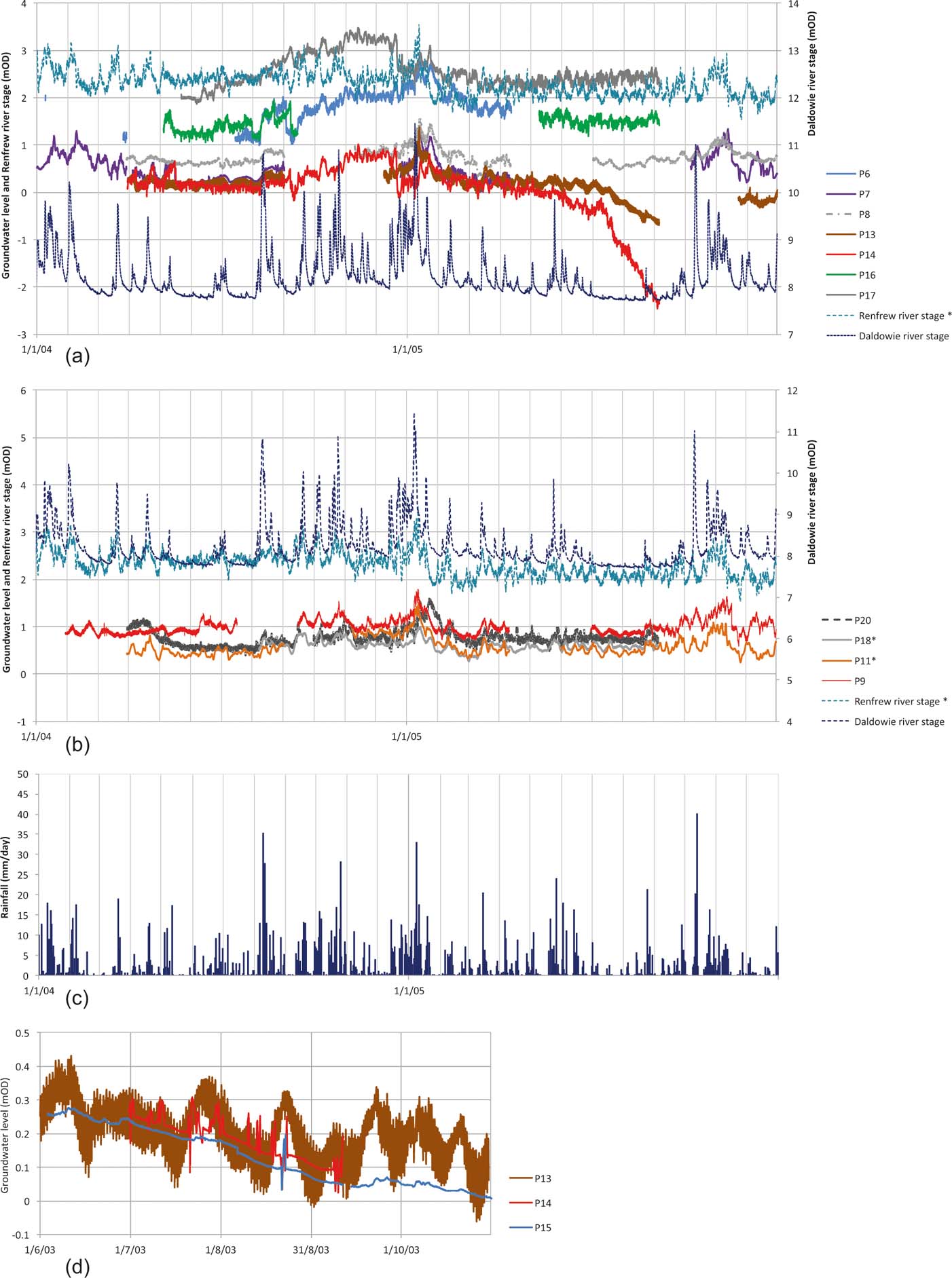
Figure 6 (a, b) Groundwater heads in the Glasgow Quaternary aquifer downstream of nominal River Clyde tidal limit, 2004–2006, and river stage at Daldowie (Figs 1, 5) and Renfrew (western gauge; Figs 1, 5). *Renfrew river stage, P11 and P18 are monthly running means, to remove tidal record. (c) Measured rainfall at Strathclyde County Park (8km upstream from eastern edge of Glasgow City Council boundary). Rainfall data from UK Meteorological Office Integrated Data Archive System, provided via the NERC Centre for Environmental Data Analysis. (d) Groundwater heads in piezometers P13, P14 and P15 (Fig. 6) over five months in 2003.
Groundwater head elevations (as height above Ordnance Datum) are highest at the upstream end of the study area, with an overall fall in elevation down-valley from SE to NW (Fig. 5b).
The relationship between groundwater head and lateral distance away from the River Clyde is less direct (Fig. 5c). Groundwater heads in individual borehole transects show evidence of hydraulic gradients both towards and away from the river, over distances of 100 to 150m. In two transects (P9/P10/P11 and P20/P19/P18), groundwater heads are higher further from the river (e.g., P20>P18; P9<P11; Fig. 6b). However, in transect P15/P14/P13 further downstream, groundwater heads further from the river are lower than closer to the river (e.g., P1, P14>15; Fig. 6d).
Groundwater heads in the monitoring boreholes fluctuate at daily (including tidal), rainfall event and seasonal timescales, correlating with rainfall events and fluctuations in River Clyde stage (Figs 6–8). The maximum seasonal fluctuation in individual boreholes over the monitored period ranges from 0.5 to 3.5m, with a median fluctuation across all boreholes of 1.4m. Only one borehole (P3; Fig. 7) shows any evidence of a falling trend in groundwater head over the monitored period, and none show any evidence of a rising groundwater head. Following individual rainfall events, groundwater heads – and river stage – rise in all monitored aquifer units. In most cases, groundwater head increases and recessions coincide with river stage fluctuations, but with distinct differences in groundwater head response in different boreholes. The largest groundwater head rises are seen in borehole P5 in the Gourock Sand Member at the upstream end of the study area (Fig. 7a), with smaller rises in P6, P7, P9, P11 (Gourock Sand/Bridgeton Sand members) and P16 (Paisley Clay Member) (Fig. 6a, b). In a few boreholes, particularly P1 and P4 (both Paisley Clay Member), groundwater head rises following individual rainfall events are more muted (Fig. 7a). Groundwater head recessions are, in most cases, slower than river stage recession (Figs 6, 7). However, occasionally, rapid groundwater head recessions occur at broadly similar times in a number of boreholes (e.g., in September 2004 in P14 and P16, and December 2004 in P6, P14 and P17) (Fig. 6a). These typically occur at relatively, but not extremely, low river stage. The boreholes affected are in all three main aquifer units and spaced over an area of up to 2km. The reasons for this are not yet clear: there is no evidence for pumping or dewatering from the Quaternary aquifer system in the study area and, in any case, pumping effects would not be expected to cause rapid drawdown across such large areas.
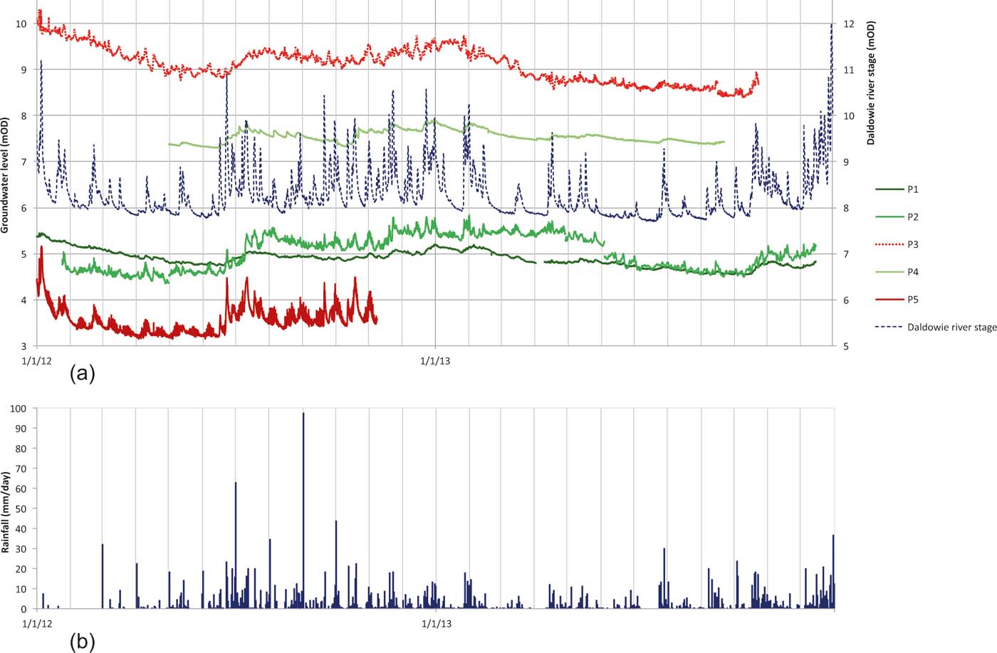
Figure 7 (a) Groundwater heads in the Glasgow Quaternary aquifer upstream of nominal River Clyde tidal limit, 2012–2013, and river stage at Daldowie (Figs 1, 5). River data provided courtesy of Scottish Environment Protection Agency. (b) Measured rainfall at Strathclyde County Park (8km upstream from eastern edge of Glasgow City Council boundary; rainfall data missing for January–February 2012). Rainfall data from UK Meteorological Office Integrated Data Archive System, provided via NERC Centre for Environmental Data Analysis.
Groundwater head fluctuations of different magnitudes also occur in response to tidal forcing (Fig. 8). Downstream of the tidal limit, groundwater heads show a strong tidal response of up to approximately 1m within 20 to 30m of the river, falling typically to 0.1 to 0.2m between 50 and 170m, and reducing to zero by approximately 200m from the river (Fig. 8c). Upstream of the tidal limit, there is no sign of tidal influence on groundwater heads in most boreholes, except for borehole P5 (30m from the river) in which bi-daily fluctuations occur, coinciding with tidal fluctuations, on days when the tidal range at Renfrew is greater than 3m (Fig. 8a).
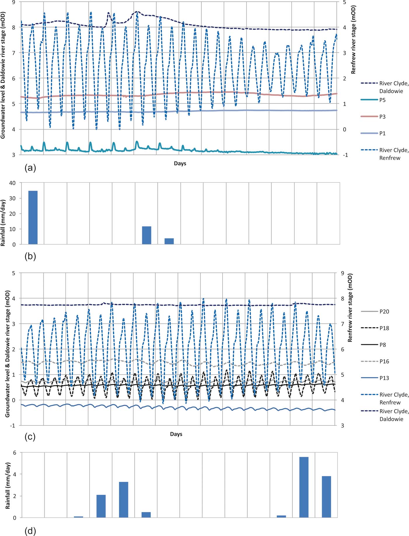
Figure 8 Groundwater heads and River Clyde stage (a, c) and rainfall (b, d) over a two-week period from 1–14 August. (a, b) 2012. (c, d) 2005. Groundwater heads show a variable response to tidal fluctuations in the River Clyde upstream (a, b) and downstream (c, d) of the nominal tidal limit (Fig. 6).
There is some evidence for confined conditions in parts of the Quaternary aquifer system, most often in the lower aquifer units. Table 2 highlights boreholes in which the monitored minimum groundwater head lies above the monitored aquifer unit – i.e., the aquifer unit is confined. All three of the boreholes that solely monitor the lowermost Bridgeton Sand Member appear to reveal confined aquifer conditions, as do two of the four boreholes monitoring only the Gourock Sand Member and one of the three boreholes monitoring the Paisley Clay Member. Of the ten boreholes monitoring both the Gourock Sand and Bridgeton Sand members, where these units are in direct contact, all show groundwater heads in the Gourock Sand Member, suggesting these two aquifer units are in hydraulic continuity.
3.3. Groundwater chemistry
A dataset of 690 inorganic chemistry analyses of groundwater samples from 136 boreholes in artificial ground or natural Quaternary sediments in Glasgow was collated from data from a number of sites along a transect through central Glasgow (Fig. 9). This is compared to a separate, baseline dataset of 111 chemistry analyses of groundwater samples from 110 boreholes or springs in Quaternary aquifers in rural areas across Scotland. The major ion chemistry of the baseline and Glasgow groundwaters is illustrated by Piper plots (Fig. 10). The range in concentration of selected groundwater chemical parameters in the baseline and Glasgow datasets is shown by box plots (Fig. 11) and their spatial distribution is shown on maps (Fig. 9).
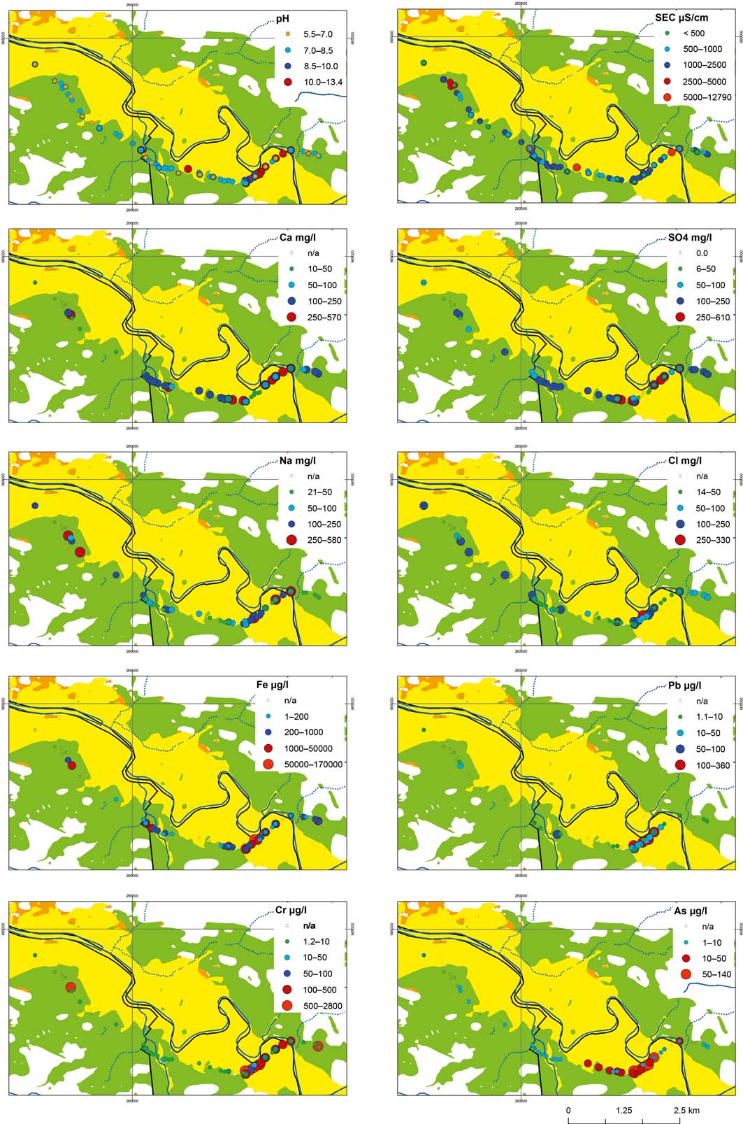
Figure 9 Spatial distribution of selected chemical parameters in Glasgow. Map background shows main Quaternary aquifer units (geology legend as Fig. 3).

Figure 10 Trilinear (Piper) plots showing major ion chemistry of groundwater from Baseline, Glasgow natural Quaternary and Glasgow Artificial Ground.
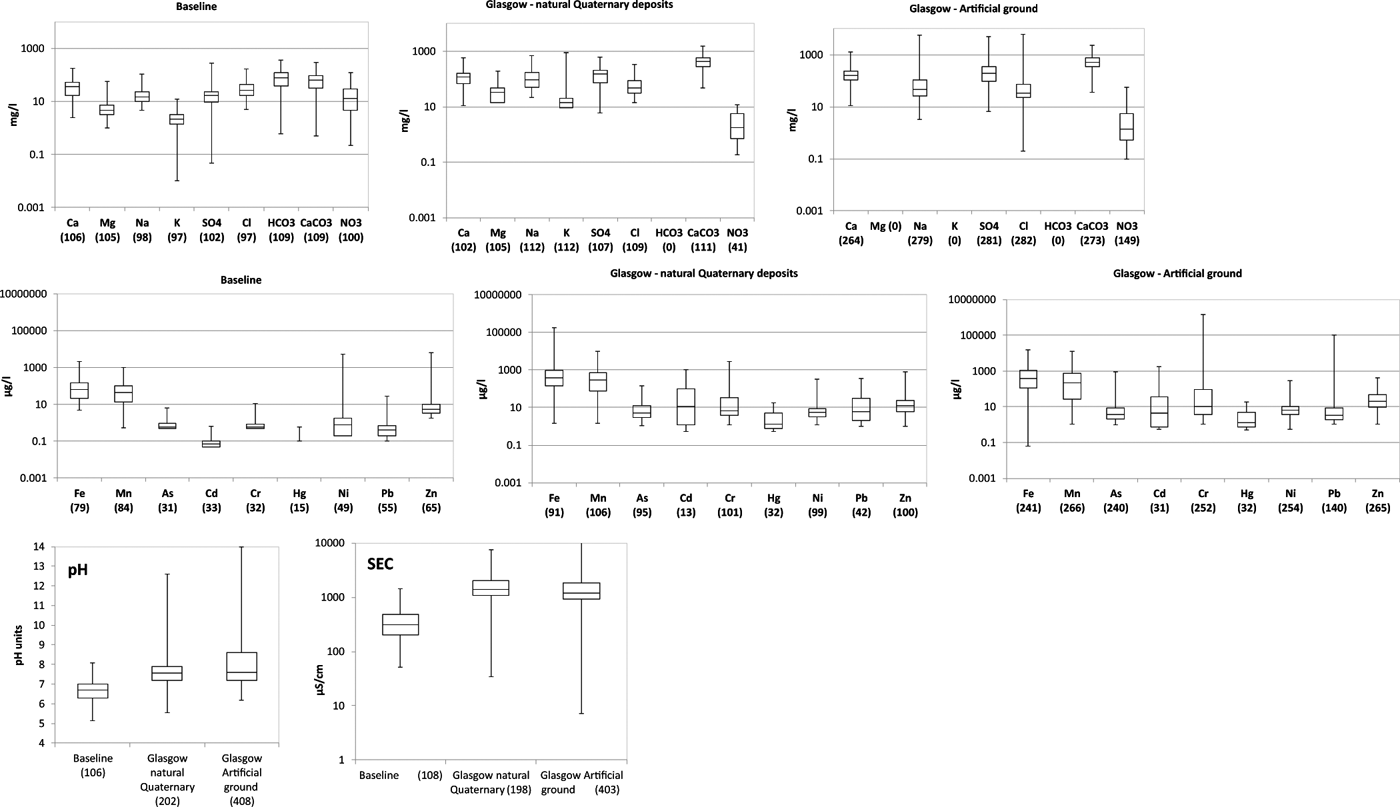
Figure 11 Summary of selected chemical parameters in baseline Quaternary groundwaters across Scotland and groundwater in natural Quaternary deposits and artificial ground in Glasgow (number of analyses in brackets). Box plots show minimum, Q25, median, Q75 and maximum values.
3.3.1. Baseline Quaternary groundwater chemistry
The baseline dataset of 111 analyses of inorganic groundwater chemistry from 110 boreholes or springs in Quaternary aquifers in rural areas across Scotland, was collated during a project that characterised the baseline chemistry of groundwaters in all of Scotland's aquifers (Ó Dochartaigh et al. Reference Ó Dochartaigh, MacDonald, FitzSimons and Ward2015b). The samples were collected between 1983 and 2007 from a range of Quaternary aquifer lithologies, particularly alluvium, glaciofluvial and raised marine deposits. The dataset was subject to consistent sample collection, laboratory analysis and quality-checking procedures. A total of 89% of the analyses had an ionic charge-balance error of less than ±5%, which is the standard criteria for assessing analytical quality; the mean ionic error was +0.39% and the total error ranged from −8 to +9%.
The broad geographic and geological range of the samples makes this dataset a useful indicator of likely baseline Quaternary groundwater conditions across Scotland, against which the chemistry of the urban Glasgow Quaternary groundwaters can be compared.
Quaternary groundwaters in Scotland are typically weakly mineralised, characterised as Ca-HCO3 to Ca-Cl type (Fig. 10), with slightly acidic pH and low-to-moderate specific electrical conductivity (SEC) (Fig. 11; Robins Reference Robins2002; Ó Dochartaigh et al. Reference Ó Dochartaigh, MacDonald, FitzSimons and Ward2015b). They show a relatively wide range in concentration of many major and minor ions – in particular, calcium, bicarbonate, nitrate, iron, manganese and nickel – but a narrow range in concentration of most trace ions, such as arsenic and many metals (Fig. 11).
3.3.2. Glasgow Quaternary groundwater chemistry
The Glasgow dataset, comprising 690 analyses of inorganic groundwater chemistry from 136 boreholes in artificial ground (440 analyses from 68 boreholes) and natural Quaternary aquifer units (250 analyses from 68 boreholes), was collated from the results of a number of land contamination and regeneration investigations carried out by different private sector organisations. Analyses of organic contaminants in groundwater were also available from many of these boreholes but are not examined in this paper, which focuses on inorganic groundwater chemistry, for which baseline data from rural areas are available for comparison.
The groundwater samples were collected between 2003 and 2013, but principally between 2007 and 2010, from boreholes that lie along a 7-km-long transect in the Clyde valley in central and eastern Glasgow, dominantly from the Gourock Sand, Bridgeton Sand and Paisley Clay members (Fig. 9). All the samples are from areas of Glasgow that were formerly heavily industrialised, and many are from known historical industrial sites. Some of the boreholes sampled are known to intercept artificial ground derived from chemical waste. It is possible, perhaps probable, that the chemistry of groundwater in at least some of the natural Quaternary aquifers is also impacted by overlying artificial ground. Detailed location data are available for around half of the boreholes sampled (38% of the analyses) (Fig. 9). The exact location of the remainder of the boreholes is unknown, but they all lie along the same transect through the central part of the Clyde valley.
The parameters determined in groundwater are not consistent across the area, as the samples were collected for different purposes during site investigations. Values for pH and SEC are available for almost 90% of the sites; a full suite of major ions, except bicarbonate, is available for approximately 50% of the samples; and bicarbonate is available (either alone or together with other major ions) for approximately 56% of the samples. A full ionic charge-balance (possible only with a full suite of major ions, including bicarbonate) could be derived for 10% of Quaternary and 51% of artificial ground samples. Of these, 22% had a charge-balance error of less than ±5%; the mean ionic balance was +4.42%; and the total error ranged from −65 to +86%.
The groundwaters in artificial ground tend to be of Ca-HCO3 to Ca-SO4 type, with some Na/K dominated waters (Fig. 10). There are fewer available values for groundwaters in natural Quaternary aquifers in Glasgow, but these tend to be of Ca or Na/K-HCO3 type (Fig. 10). Glasgow groundwaters, in both natural Quaternary aquifers and artificial ground, are more mineralised than baseline Quaternary groundwaters. In particular, compared to the baseline Quaternary groundwaters, Glasgow groundwaters have: higher conductivity (typically greater than 1000μScm–1); higher pH (and groundwaters in artificial ground particularly show a much greater range in pH values); higher average concentrations of most major ions and many trace metals, including As, Cd, Cr, Hg and Pb; and greater variability in many ions, particularly many trace metals and the major ions Na and SO4 (Fig. 11). Nitrate (NO3) is the only major ion that is lower in concentration (based on median values) in Glasgow groundwaters than in the rural baseline dataset (Fig. 11).
Spatially, the distribution of available inorganic chemistry data for Quaternary Glasgow groundwaters (Fig. 9) shows little evidence of any chemical evolution across the aquifer system, but does indicate areas of particular shallow groundwater contamination. Highly mineralised groundwaters (indicated by SEC values greater than 1000μScm–1) and higher than baseline concentrations of major ions, including Ca, SO4, Na and Cl, occur across the study area of central and E Glasgow (Fig. 9). Most of the Glasgow groundwaters show alkaline pH, contrasting with the baseline waters, and in some areas, particularly in the SE of the study area, very alkaline pH (Fig. 9). Trace ions, such as Cr, As and Pb, tend to show elevated concentrations only in specific zones, in particular the same area in the SE of the study area (Fig. 9). Iron concentrations are high across much of the study area, but are also particularly elevated in some sites, including the same area in the SE. Naturally high iron concentrations are common in groundwater in Scotland, linked to low pH, organic-rich, low-oxygen conditions, but are rarer in the alkaline conditions present in most of the Glasgow groundwaters, and so the high values seen in Glasgow are likely to be linked to contamination.
This area in the SE of the study area has a concentration of significant historical pollution associated with industrial metal processing sites, including a large steelworks, which produced alkaline lime waste, and a Cr ore processing plant that is associated with extensive local deposition of Cr waste (also rich in other trace metals, including Fe). This area also has a significant extent and thickness of artificial ground formed of building rubble and cement, which tends to be alkaline in nature, and is associated with elevated concentrations of many trace metals in soils, including As, Cr, Pb and Fe (Fordyce et al. Reference Fordyce, Ó Dochartaigh, Bonsor, Ander, Graham, McCuaig and Lovatt2018).
4. A conceptual model of the Quaternary groundwater system in Glasgow
The Quaternary geological sequence in the central Clyde valley in Glasgow forms a shallow complex aquifer system that comprises a series of hydrogeologically heterogeneous lithostratigraphic units, with variable hydraulic connectivity between different aquifer units, and between the Quaternary aquifer system and surface waters.
Three Quaternary geological formations – the Bridgeton Sand, Gourock Sand and Paisley Clay members – together form a linear aquifer system approximately 2–3km wide and 10–30m thick (Fig. 3) beneath Glasgow. This groundwater system is highly heterogeneous. Natural variations arise from lithological differences and the changing influence of the tidal River Clyde on groundwater with distance from the river. Anthropogenic heterogeneity arises from urban influences such as altered surface permeability and subsurface flowpaths, and urban recharge.
The uppermost of these three aquifer units, the Gourock Sand Member, and the lowermost, Bridgeton Sand Member, are dominated by coarse-grained sediment (gravel and/or sand) and have moderately to locally high hydraulic conductivities. The intervening Paisley Clay Member (which sometimes overlies the Bridgeton Sand Member with no overlying Gourock Sand Member) is dominated by fine-grained sediment (silt and/or clay), but contains significant layers or lenses of coarser-grained sediment, and, as a consequence, appears to show locally moderately high hydraulic conductivity, although at a city scale it is less permeable than the other two units.
The Gourock Sand and Bridgeton Sand members appear to form a single hydraulically connected aquifer unit where the former directly overlies the latter. The Paisley Clay Member, although less permeable overall than the other two aquifer units, is also hydraulically active, and where it separates the two other aquifer units, groundwater in all three units is likely to be in hydraulic connectivity.
Other Quaternary formations in Glasgow are likely to be less significant hydrogeologically, because they are typically thinner, laterally restricted and/or have relatively low permeability. Where small but permeable gravel- and sand-dominated units occur, they may allow local groundwater storage and flow, and where these directly over- or underlie one of the main three aquifer units, they may contribute to overall groundwater storage and flow in the main aquifer, but they are not likely to be significant at a city scale.
The Quaternary aquifer system is overlain by widespread, heterogeneous anthropogenic (artificial) ground, and the surface land cover is heavily urbanised, which will have variable impacts on natural hydrogeological processes. The generally high permeability and widely unconfined nature of the upper parts of the natural Quaternary aquifer system mean that it is likely to accept potential recharge, reaching its upper surface via any artificial ground. Preliminary groundwater modelling estimated average long-term recharge to the aquifer system at 275mmyear–1 (Turner et al. Reference Turner, Mansour, Dearden, Ó Dochartaigh and Hughes2014).
Groundwater-flow direction through the Quaternary aquifer system at a city scale is dominantly down-valley, from SE to NW. Groundwater head and river-level monitoring data also show a component of groundwater flow convergent towards the River Clyde from the edge of the Quaternary aquifer system. Local reversal of this convergent flow in one area in centre-W Glasgow has also been observed, driven by a groundwater head gradient from the river into the aquifer system at least 50m away from the river. The causes of this variation in groundwater-flow direction are unclear, but may be linked to local-scale hydrogeological heterogeneities, or to the influence of buried urban infrastructure, such as building and quay walls and engineered river banks.
Two mechanisms drive the strong observed relationship between groundwater head response and rainfall and river stage fluctuations. Rapid groundwater head change – on a scale of hours – is driven primarily by pressure changes in the aquifer system as it responds to rising and falling piezometric stage in the River Clyde. Slower, longer-lasting groundwater head changes – on a scale of days to weeks – occur in response to the physical flow of water through the aquifer system, from the infiltration of rainfall at the ground surface and/or the infiltration of river water through the river bed. These responses are sometimes termed celerity and velocity, respectively (McDonnell & Beven Reference McDonnell and Beven2014). The rapid, pressure-driven connection between river and groundwater is clearly demonstrated by tidal forcing of groundwater heads. This effect is evident throughout the tidal zone of the River Clyde in Glasgow, in all of the monitored aquifer units, and at distances of up to 200m from the river, although the greatest effects are seen closest to the river. This agrees with observations from other large Quaternary valley aquifers, such as in the Findhorn valley in NE Scotland, where the direct influence of the river on groundwater is greatest within 250m of the river (MacDonald et al. Reference MacDonald, Lapworth, Hughes, Auton, Maurice, Finlayson and Gooddy2014). A small tidal influence on groundwater head is also seen some 3km (straight-line distance) upstream of the navigational tidal limit of the River Clyde, indicating that the tidal impact on groundwater extends further upstream than this nominal limit.
The consistently greater mineralisation of groundwaters in Glasgow compared to that in rural areas, including higher concentrations of most major and trace ions, indicates widespread urban contamination, including from industry. Widespread elevated concentrations of major ions such as Ca, K and SO4 are likely to be linked to contamination from urban waste material, such as cement, metals, mine spoil or chemicals from activities such as building, manufacturing, mining and industrial processes such as chromite ore processing. The generally relatively low NO3 values in urban groundwater indicate that sewage contamination of groundwater is not widespread. The highly elevated concentrations of trace metals, including As, Cr and Pb, in a particular area in the SE of the study area, indicates that historical industrial contamination at specific sites, from activities including mining, chromite ore processing and the manufacture of iron and steel, is still impacting on the quality of groundwater in the Quaternary aquifer system.
Based on the spatial distribution of data available to this study, there is no evidence of evolution of groundwater chemistry along the dominant down-valley groundwater flow line through Glasgow. The effects of contamination on groundwater chemistry are likely to be far stronger than any evolutionary changes with groundwater flow.
The presence and active flow of groundwater observed in the Carboniferous bedrock and the overlying Quaternary aquifers mean there is likely to be a hydraulic connection between the two. Previous authors have speculated that regional groundwater flow through the Carboniferous aquifer may be towards Glasgow (Robins Reference Robins1990; Hall et al. Reference Hall, Browne and Forsyth1998), which suggests that within Glasgow there may be upward groundwater flow through the Carboniferous aquifer towards the Quaternary aquifer system. However, the lack of groundwater data for the Carboniferous bedrock aquifer means that it is not yet possible to characterise or quantify any such connection. This is a key gap in our understanding of Glasgow's hydrogeology. A better understanding is needed of the connectivity of groundwater in Quaternary and bedrock aquifers, and of surface water and groundwater interactions. This will enable a more effective assessment of groundwater status, and of specific issues such as the relationship between shallow groundwater contamination and the chemistry of groundwater in the bedrock aquifer, or the impacts of future activities, such as the potential effects of abstracting thermal energy from mine waters on groundwater in the overlying Quaternary aquifer system.
5. Conclusions
Understanding the complexity of shallow urban groundwater systems, and their interaction with surface water and land systems, is critical if we are to better benefit, and manage any threats, from urban groundwater. This paper illustrates how conceptual understanding of a shallow urban groundwater system can be improved in cities where shallow groundwater is not widely abstracted and, consequently, little groundwater information exists. The conceptual model of the Quaternary groundwater system in Glasgow described here has been developed through a series of dedicated groundwater field and modelling studies, which made extensive use of third-party private sector and local authority data originally collected for a range of purposes. The success of this approach in collating and synthesising groundwater information from many sources is demonstrated by the significant improvement of our knowledge of the Quaternary hydrogeology of Glasgow, which would not have been possible by relying solely on new, dedicated groundwater data collection. A similar approach can be recommended in other cities with similarities in hydrogeology, history and data availability.
This work has allowed us to identify many remaining gaps in the understanding of the Quaternary groundwater system in Glasgow, which can only be addressed by the future collection of relevant data, including groundwater head and quality monitoring in targeted aquifers and locations across the city. One key area for groundwater investigations, to help reduce urban flooding and surface water contamination, is to better characterise groundwater–surface water interactions along surface water tributaries (including culverted reaches) and, more widely, along the River Clyde. Another key area, which would underpin the potential future use of groundwater from the underlying bedrock aquifer as well as the Quaternary aquifer system, is to characterise and quantify the hydraulic connectivity between the Quaternary and underlying Carboniferous bedrock aquifers.
Around the world, as the regeneration of post-industrial cities continues, and pressures on urban environments continue to grow – for example, through climate change and the increasing frequency of extreme weather events – the drivers for better management of shallow urban groundwater will become even stronger. More effective management of all urban water flows and quality is needed in order to optimise the role that shallow groundwater can play in providing benefits such as maintaining healthy urban river flows, mitigating the impact of extreme rainfall events by receiving additional recharge, or a low-carbon heating and cooling resource; and minimising any potential threats, such as groundwater flooding. This will rely on a good understanding of shallow groundwater and how it interacts with the wider urban environment.
6. Acknowledgements
The authors thank Glasgow City Council for kindly providing access to groundwater monitoring data and the Scottish Environment Protection Agency for kindly providing access to river stage data, and Keith Henderson of BGS for his assistance with the diagrams. The two reviewers are thanked for their very constructive comments that helped us improve the manuscript. This paper is published with the permission of the Executive Director of the British Geological Survey. BGS/NERC reference: PRP18/033.


