INTRODUCTION
Wetlands have sustained human activities since prehistoric times, including freshwater provisioning, vegetation cover, fauna resources, waterlogged soils, and nutrient and sediment recycling (e.g., Aber et al., Reference Aber, Pavri and Aber2012). From the perspective of Quaternary geology, paleowetland deposits constitute key geohistorical archives, widely used to reconstruct past fluctuations in the global hydrological cycle (e.g., Alley et al., Reference Alley, Marotzke, Nordhaus, Overpeck, Peteet, Pielke and Pierrehumbert2002; Junk et al., Reference Junk, An, Finlayson, Gopal, Květ, Mitchell, Mitsch and Robarts2013; Pigati et al., Reference Pigati, Rech, Quade and Bright2014), forcing mechanisms for glacial-interglacial cycles (Vandergoes et al., Reference Vandergoes, Newnham, Preusser, Hendy, Lowell, Fitzsimons, Hogg, Kasper and Schlüchter2005), and historical anthropogenic pollution (Bindler, Reference Bindler2006; Vleeschouwer et al., Reference Vleeschouwer, Vanneste, Mauquoy, Piotrowska, Torrejón, Roland, Stein and Roux2014). This particularly applies to arid regions, where paleoenvironmental proxy records are limited. Although considerable progress has been made in defining physical, sedimentological, and biological features of ground-water discharge deposits (GWD; e.g., Tooth and McCarty, Reference Tooth and McCarthy2007), further research is required to improve understanding on structure and function. Specifically, there is a knowledge gap related to the geomorphological and climate controls on hydrological balances, which may lead to misinterpretations on the direction, magnitude, and timing of paleohydrological changes.
There are many descriptions of semidesert to desert wetlands that are directly fed by streams, snowmelt, or by an emerging water table due to the intersection of regional aquifers with the surface (e.g., Sáez et al., Reference Sáez, Godfrey, Herrera, Chong and Pueyo2016; Herrera et al., Reference Herrera, Custodio, Chong, Lambán, Riquelme, Wilke and Jódar2016). Little information is available on modern wetlands from arid areas disconnected from regional ground-water systems and sustained exclusively by direct precipitations, however, possibly due to the fact it is less likely they will be preserved throughout geological records. Recently, Calhoun et al. (Reference Calhoun, Mushet, Bell, Boix, Fitzsimons and Isselin-Nondedeu2017) described modern examples from an ecological perspective. In parallel, a specific case of temporary wetland formation was described by Melly et al. (Reference Melly, Schael and Gama2017), corresponding to a modern analog from a semiarid region in South Africa. The authors refer to “perched” wetlands as systems where impermeable layers close to the surface allow for wetland development in a semiarid environment.
In the Atacama Desert, one of the driest places on Earth, modern and ancient GWD are abundant in the high-Andean basins. At 3200 m above sea level (m asl), these occur as peat-accumulating wetlands (Andean “bofedales”) on flat terrains or sloping basins of the Altiplano, sourced by springs, snowmelt, or stream discharge (Squeo et al., Reference Squeo, Warner, Aravena and Espinoza2006; Schittek et al., Reference Schittek, Forbriger, Mächtle, Schäbitz, Wennrich, Reindel and Eitel2015). At lower elevations, wetlands are associated with floodplains within incised fluvial valleys, or as distinct springs that run off at the base of the Andean slopes or through fault systems (Rech et al., Reference Rech, Quade and Betancourt2002, Reference Rech, Pigati, Quade and Betancourt2003; Grosjean et al., Reference Grosjean, Núñez and Cartajena2005; Squeo et al., Reference Squeo, Warner, Aravena and Espinoza2006; Quade et al., Reference Quade, Rech, Betancourt, Latorre, Quade, Rylander and Fisher2008; Gayo et al., Reference Gayo, Latorre, Jordan, Nester, Estay, Ojeda and Santoro2012a; Sáez et al., Reference Sáez, Godfrey, Herrera, Chong and Pueyo2016; Pfeiffer et al., Reference Pfeiffer, Latorre, Santoro, Gayo, Rojas, Carrevedo and McRostie2018).
To our knowledge, paleowetlands sustained by local perched water tables remain undocumented in the Atacama Desert or the western Andean slope. This study examines geomorphological, sedimentological, and vegetational data to describe deposits associated with the active perched Humedal La Estrella wetland complex (3000 m asl, 18°S), to determine the factors and processes contributing to its origin and development. More importantly, this study will explore the potential of this paleowetland as a geohistorical archive that include records of historical variations in the regional/local hydrological cycle. Finally, considering the local archaeological record, possible patterns of wetland-resource use by pre-Hispanic societies that inhabited the highlands of the Atacama Desert are explored.
REGIONAL SETTING
Geology
The study area is located in the Arica and Parinacota region of northern Chile (Fig. 1A). Similar to the rest of the area over the central Andes west of the Cordillera, the region is characterized by four major physiographic features (Fig. 1A): the Coastal Cordillera, the Central Depression, the Precordillera (the foothills of the western Andes Cordillera), and the Western Cordillera (Mortimer and Saric, Reference Mortimer and Saric1972; Paskoff, Reference Paskoff1979; Tosdal et al., Reference Tosdal, Clark and Farrar1984; Naranjo and Paskoff, Reference Naranjo and Paskoff1985; Niemeyer, Reference Niemeyer and Hidalgo L.1989). This wetland complex (18°32′31′′S, 69°32′34′′W; 3300 m asl) lies within the Precordillera region, which ranges between 2500 and 3800 m asl (Garcia et al., Reference Garcia, Gardeweg, Clavero and Hérail2004). It is part of the Tignamar Basin, a 51-km-long mountainous river that originates at approximately 4300 m asl in the Cordillera, with an east-west orientation. It is a tributary to the San José River that drains into the Azapa Valley (Fig. 1A). Locally, the geology is dominated by the Huaylas Formation (Fig. 1B), a middle–upper Miocene fluvio-deltaic formation mainly composed of subhorizontal sedimentary deposits intercalated with tuffaceous lenses (Garcia et al., Reference Garcia, Gardeweg, Clavero and Hérail2004). To the northwest, the Huaylas Formation covers the hillier terrain of the lower Miocene ignimbritic Oxaya Formation (Fig. 1b).
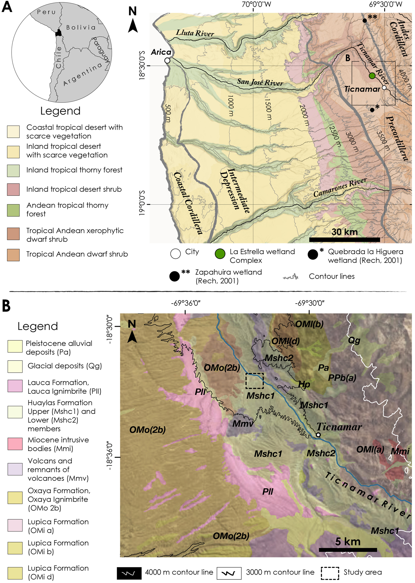
Figure 1. (color online) (A) Location map of the La Estrella wetland complex. The major regional physiographic provinces are delimited by thick gray lines. (B) Main geologic formations around the study area. Modified from Garcia et al. (Reference Garcia, Gardeweg, Clavero and Hérail2004).
Climate and hydrology
About 80% of precipitation occurs during the austral summer (Vuille and Keimig, Reference Vuille and Keimig2004), associated with the South American summer monsoon (Zhou and Lau, Reference Zhou and Lau1998) that brings moisture from the Amazon Basin and/or Gran Chaco (Garreaud et al., Reference Garreaud, Vuille and Clement2003). The high summits of the Andes generate a strong rain-shadow effect that prevents the westward advection of moist air masses from eastern South America. As a consequence, the western Andean slope (15–24°S) is characterized by a strong elevational gradient in rainfall amounts (Houston and Hartley, Reference Houston and Hartley2003), that results in intense hyperaridity (<5 mm/yr) at elevations below 2200 m asl, and arid conditions (<35 mm/yr) at 3000 m asl. Mean annual rainfall rapidly increases, however, from 120 mm/yr at 3200 m asl to ~300 mm/yr at 5000 m asl. Potential evaporation rates of >2500 mm/yr occur across the Atacama hyperarid core (<2200 m asl), but a decrease occurs with elevation, as more moisture becomes available (Houston, Reference Houston2006). Overall, potential evaporation rates decrease significantly during the summer due to increased cloudiness and the resulting effects on net radiation (Houston, Reference Houston2006).
The hydrogeology of northernmost Chile consists of two major systems: the internally drained basins on the eastern flank of the Cordillera and the externally drained basins of the Andes foothills. The main exorheic basins of the region include the Lluta, San José, Vitor, and Camarones rivers, and the minor Escritos and Gallinazos basins (Garcia et al., Reference Garcia, Gardeweg, Clavero and Hérail2004). The Azapa basin encompasses the Tignamar, Río Seco, and the San José tributaries. These watercourses are supported by discharge from unconfined aquifers contained within Quaternary sedimentary fill (DGA, 1986).
According to Squeo et al. (Reference Squeo, Warner, Aravena and Espinoza2006), high-altitude central Andes wetlands occur in areas where localized ground water and/or superficial discharge generate permanently waterlogged soils. Based on hydrogeological criteria, three major categories are defined: (1) sloping peatlands, fed by local flow systems including snowmelt and surface streams; (2) basin peatlands, which include cirque basins, shallow depressions, and areas of low relief related to glacier streams and regional ground-water flow systems; and (3) flat peatlands, which are fed mainly by ground-water flow systems, and partly by stream/rivers and snowmelt. The wetlands included in this study are classified as flat. This study, however, indicates that its hydrogeology is not consistent with the criteria proposed by Squeo et al. (Reference Squeo, Warner, Aravena and Espinoza2006). This inconsistency is not unusual, as it is recognized that several functioning features of the high-altitude central Andes wetlands remain poorly understood, such as water sourcing, response to climate variability, and spatiotemporal evolution.
Vegetation
Across the western Andean slope, the marked elevational gradient in rainfalls leads to significant spatial variations in the distribution of vegetation (Fig. 1; Villagrán et al., Reference Villagrán, Armesto and Arroyo1981; Arroyo et al., Reference Arroyo, Squeo, Armesto and Villagran1988). Hillslope vegetation, i.e., relaying on direct precipitation, is confined to elevations above 2200 m asl (Villagrán et al., Reference Villagrán, Armesto and Arroyo1981; Arroyo et al., Reference Arroyo, Squeo, Armesto and Villagran1988), and three main vegetation belts develop across the ascendent precipitation gradient. Between 2200 and 3200 m asl, the Pre-Puna belt is characterized by a sparse xerophytic subshrub with columnar cacti; above 3200 m asl and up to 4000 m asl, denser shrubland is dominated by Baccharis tola and accompanied by cacti and tussock grasses. Here, in the so-called Puna belt, primary productivity and vegetation cover peak. Finally, at elevations above 4000 m asl, the high-Andean steppe belt is dominated by tussock grasses accompanied by and rosette plants.
Dense and highly productive wetlands typically develop associated with flooded areas at an elevation between 3200 and 5000 m asl (Squeo et al., Reference Squeo, Warner, Aravena and Espinoza2006). Here, vegetation is mainly composed of cushion plants and some sparse grasses (Ruthsatz, Reference Ruthsatz2012) with a relatively homogeneous taxonomic composition, including taxa that are widely distributed across the Andean Cordillera (Arroyo et al., Reference Arroyo, Villagrán, Marticorena, Armesto, Veloso and Bustos1982; Villagrán et al., Reference Villagrán, Kalin Arroyo and Marticorena1983).
Human occupation
The Precordillera of Arica preserves vestiges of human occupation dating back to 10.5 ka, indicating the presence of mobile groups of hunter-gatherers who first explored the region and colonized new areas of the South American continent (Santoro et al., Reference Santoro, Osorio, Ugalde, Sepúlveda, Cartajena, Standen, Gayó, Maldonado, Falabella, Sanhueza, Uribe, Aldunate and Hidalgo2016; Osorio et al., Reference Osorio, Steele, Sepúlveda, Gayo, Capriles, Herrera, Ugalde, De Pol-Holz, Latorre and Santoro2017). For approximately 7000 yr, these first inhabitants gradually decreased their mobility, and began to utilize sources of vegetal and animal available in the environment. This led to important changes in human-environment relation through the management of these resources, mainly camelids (Dudognon and Sepúlveda, Reference Dudognon and Sepúlveda2016). The transition towards the Formative or Neolithic Andean in the region was so gradual that until at least 1400 yr it is not possible to observe significant changes in the way of life of these high-Andean populations (Sepúlveda et al., Reference Sepúlveda, Cornejo, Osorio, Uribe and Llanos2018). This gradual transition occurs despite interactions with other sedentary groups; potters, farmers, and pastoralists that were settled in neighboring regions (Sepúlveda et al., Reference Sepúlveda, Cornejo, Osorio, Uribe and Llanos2018). From the twelfth century AD onwards, large settlements indicate a novel usage of the Precordillera, related to significant agricultural and pastoral practices requiring a strong sedentary imprint formed around three principal localities with considerable farming practices in the surrounding areas (Muñoz Ovalle, Reference Muñoz Ovalle2005). Farms are related to the presence of terraces and corrals for hosting domesticated camelids (Saintenoy et al., Reference Saintenoy, Ajata, Romero and Sepulveda2017). Subsequently, the Incas settled in the region from the fifteenth century AD onwards. Finally, the Spanish conquest from the sixteenth century AD modified the pattern of local settlement, generating a reorganization of the territory and new forms of control over local production and resources.
METHODS
Areas surveys were carried out using 5-m, high-resolution Pléiades satellite images (visible and near-infrared bands). A false infrared image (combining bands 4, 3, and 2) and the Normalized Difference Vegetation Index (Verdin, Reference Verdin1996) were used to delimit the wetland deposits. An initial analysis was conducted in the field through the investigation of exposures in hand-made ditches located along linear transects.
The deepest outcrop studied, Wetland Area (WA) 1d, was sampled for micromorphology with a 5-cm resolution applied for particle-size and geochemical analysis. Thin sections were prepared on six undisturbed samples according to a standard micromorphological protocol (Guilloré, Reference Guilloré1980), with an analytic description following the terminology proposed by Stoops (Reference Stoops and Vepraskas2003). Soils classification in the field was based on the World Reference Base for soil resources (FAO-WRB, 2014). Grain-size samples were processed using a Horiba LA-950 laser particle-size analyzer in the PACEA laboratory (see Supplementary Information in Sitzia et al. [Reference Sitzia, Bertran, Sima, Chery, Queffelec and Rousseau2017] for details on methods). Energy-dispersive X-ray fluorescence was performed using a portable SPECTRO X-SORT (40 kV, 50 μA) on previously ground samples, compacted into pellets. Details of the measurement protocol are given in Supplementary Table 1. Logarithm component ratios were used to analyze geochemical data as an alternative to the raw percentages, following Aitchison (Reference Aitchison1986). Multivariate analysis was carried out using the compositional biplot described by Aitchison and Greenacre (Reference Aitchison and Greenacre2002). Previous to the analysis, a non-parametric replacement was carried out for the null values below the detection limit, following the method by Martín-Fernández et al. (Reference Martín-Fernández, Barceló-Vidal and Pawlowsky-Glahn2003). Compositional data were analyzed using the CoDaPack software (Comas and Thió-Henestrosa, Reference Comas and Thió-Henestrosa2011). The mineralogical composition of two samples was studied by X-ray diffraction on ground sediment in a silicon calibrated PANalytical X'Pert diffractometer, using the Kɑ1 of a copper anticathode operated at 40kV and 40mA. Mineralogical identification was carried out through the comparison with the JCPDS-ICDD database using the DIFFRACPLUS Eva software.
Vegetation in the wetland complex as well as in immediately adjacent areas was characterized using the sample quadrant method. The minimal area procedure was used to estimate the quadrat size (Kent Reference Kent2011). A total of 28 quadrats were established to record the frequency and cover of each specimen and collect representative individuals for subsequent taxonomic identification. Species were identified using specialized literature and the taxonomic key proposed by Zuloaga et al. (Reference Zuloaga, Morrone and Belgrano2008). Finally, vegetation surveys are used as the basis of describing the function of the Humedal La Estrella wetland complex.
Our chronology is based on radiocarbon ages on charcoal and organic sediments collected from four sections of the paleowetland deposits (Table 3). Obtained ages were calibrated using the SHCal13 calibration curve under the Calib 7.0.4 software (Stuiver et al., Reference Stuiver, Reimer and Reimer2018). In WA1d section (Figs. 2 and 3), the 2A horizon was dated using both organic sediment and charcoal to evaluate the reliability of the primary provenance estimations from charcoal. Radiocarbon determinations for both samples are coherent but statistically different (t-test = 7.86, x2 = 3.84, df = 1), yielding a pooled mean age of 325 ± 20 14C yr BP for the 2A horizon (charcoal age = 285 ± 25 14C yr BP, organic sediment = 390 ± 30 14C yr BP).

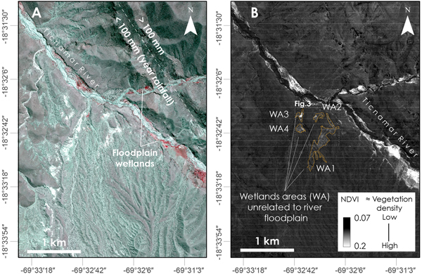
Figure 2. (color online) (A) False color infrared image. (B) Normalized Difference Vegetation Index (NDVI) map, identifying the four major wetland areas from the study. Base layer for maps: 5-m resolution Pléiades satellite image.
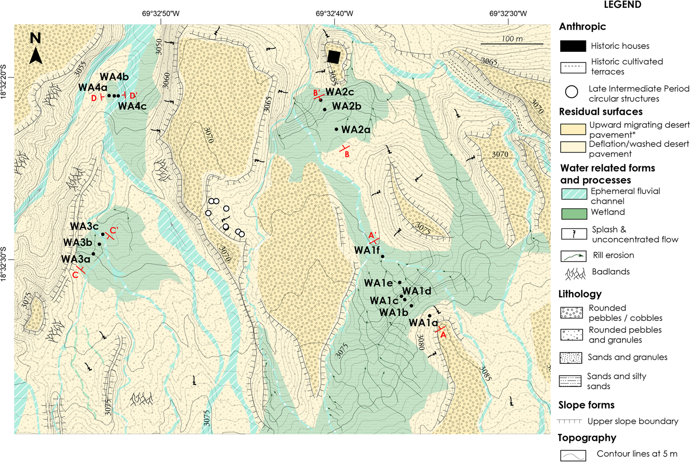
Figure 3. (color online) Detailed geomorphological map of identified wetlands (see Fig. 2c for exact map extension). Geomorphological map symbology based on Gustavvson et al. (Reference Gustavsson, Kolstrup and Seijmonsbergen2006).
Systematic archaeological surveys were carried out in the Tignamar basin, as part of a wider project in the Precordillera of northernmost Chile. The prospection methods for this project are published in Saintenoy et al. (Reference Saintenoy, Ajata, Romero and Sepulveda2017). The surveys contribute to understanding hunter-gatherer settlement patterns between cal. 10500 and 3500 years BP (Sepúlveda et al., Reference Sepúlveda, Cornejo, Osorio, Sitzia, Saintenoy and Espinoza2017A, Reference Sepúlveda, Saintenoy, Cornejo, Dudognon, Espinoza, Guerrero-Bueno and Cerrillo-CuencaB), and sedentary and agriculture populations between the twelfth and fifteenth centuries (Saintenoy et al., Reference Saintenoy, Ajata, Romero and Sepulveda2017). The surface records correspond mainly to: (1) small isolated lithic knapping events; (2) concentrated lithic knapping areas; (3) isolated circular enclosures; (4) circular structures used as dwellings, and other complex sets of circular enclosures identified as pens, which have been defined as villages due to the presence of lithics and dispersed ceramic material; (5) parallel stone alignments interpreted as channels indicating sectors used for agricultural cultivation; (6) sloping agricultural terraces; and (7) rock-shelters with or without rock art paintings. This study reevaluates and verifies available data in the field, specifically within the wetland area. Four arbitrary sectors are defined within a radius of ca. 800 m around the wetland complex. These sectors were used to classify the archaeological findings from the surface and to discuss possible links between visible human settlement and river courses and wetlands, including the La Estrella wetland complex.
RESULTS AND INTERPRETATION
Geomorphology and vegetation
The false color infrared image (FCIR) and the NDVI map allows for the discrimination between the Tignamar River floodplain, its eastern tributaries, and four areas with intermediate values (Fig. 2A and B). As observed in other desert regions with lower vegetation density (e.g., Qi et al., Reference Qi, Chehbouni, Huete, Kerr and Sorooshian1994), areas with higher vegetation density had higher values of NDVI (Fig. 2B). The white areas appearing as an NNW-SSE narrow strip in the FCIR, do not appear in the NDVI image. These areas correspond to an intercalation of volcanic tuff in the Huaylas Formation (Garcia et al., Reference Garcia, Gardeweg, Clavero and Hérail2004) as verified in the field.
Field inspection and mapping confirm that the four areas with intermediate values are wetlands and that areas WA1 and WA2 are interconnected (Fig. 3). The geomorphological map of wetlands (Fig. 3) confirms the following: (1) internal topographic diversity, since flat areas, as well as slopes, are observed; (2) a clearly developed pattern of internal drainage; (3) the emergence of minor water rivulets at the contact between the tuff and the alluvial sediments of the Huaylas Formation; (4) wetlands are cut by small ephemeral channels, which are part of the Huaylas Formation drainage pattern (Fig. 4B); and (5) wetland deposits are found on top of the tuff.
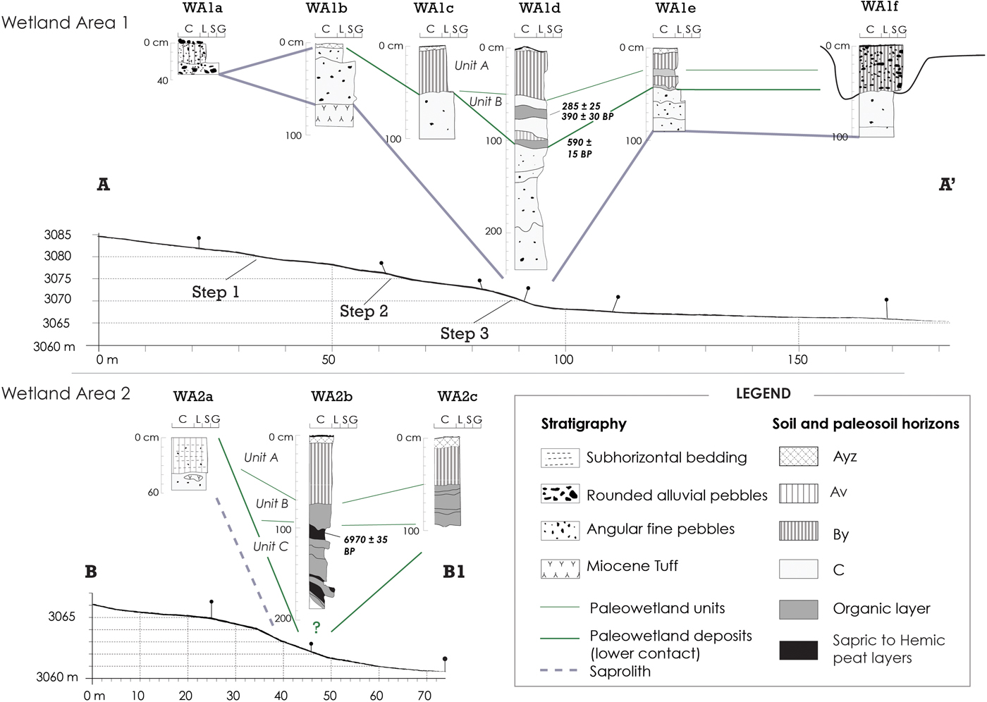
Figure 4. Synthetic stratigraphic logs of Wetland Areas (WA) 1 and 2.
Vegetation composition and structure are substantially different to the high-Andean peat-accumulating wetlands (Supplementary Table 3), excluding Carex sp., Frankesia sp., Cumulopuntia sp., Stipa sp., Deyeuxia sp., and Wermeria sp., that are present in both systems. The perched wetland in this study lacks key cushion plants (Oxychloe andina and Distichia muscoides), perennial grasses (Festuca sp.), and semiaquatic taxa (Juncaceae) that are common in high-elevation bofedales (Teiller, Reference Teiller1998; Squeo et al., Reference Squeo, Warner, Aravena and Espinoza2006; Villagrán et al., Reference Villagrán, Kalin Arroyo and Marticorena1983). In fact, halophytic taxa that dominate in hyper-saline and semipermanent flooded wetlands (e.g., Distichlis humilis, Frankenia triandra, and Carex spp.; Navarro, Reference Navarro1993; Buttolph, Reference Buttolph1998; Teiller, Reference Teiller1998) exhibit the highest relative frequency in our study site (Supplementary Table 3). This implies that our wetland complex should be considered as a saline wetland, similar to the wetlands within modern salars, rather than a bofedal sensu Squeo et al. (Reference Squeo, Warner, Aravena and Espinoza2006).
Stratigraphy and soil description
Paleowetland deposits have been divided into three main pedostratigraphic units (A, B, and C) based on stratigraphic and soil description. Seven radiocarbon ages (Table 1) on charcoals and organic sediment from paleosols in sections WA1d, WA2b, WA3b, and WA4b (Fig. 4 and 5) verify the stratigraphy observed in the field. The following section provides a brief description of the Miocene tuff intercalation and the characteristics of Units C, B, and A (from oldest to youngest, respectively). Reference is made to the WA1d section (Fig. 6), while the results and a description of grain-size and geochemical analysis are detailed in the Supplementary Information.
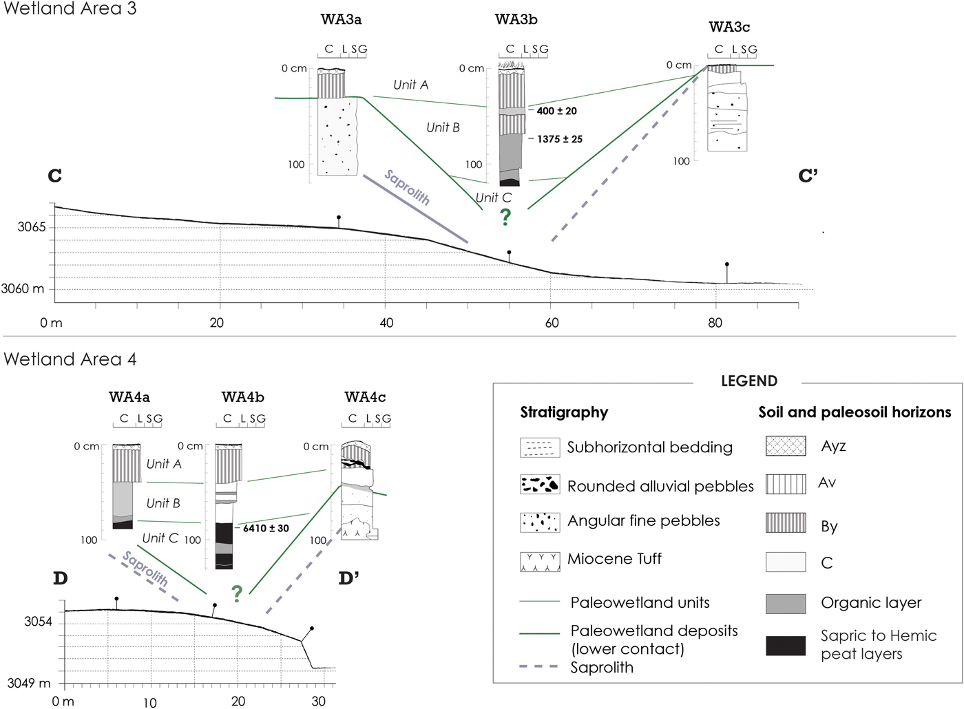
Figure 5. Synthetic stratigraphic logs of Wetland Areas (WA) 3 and 4.
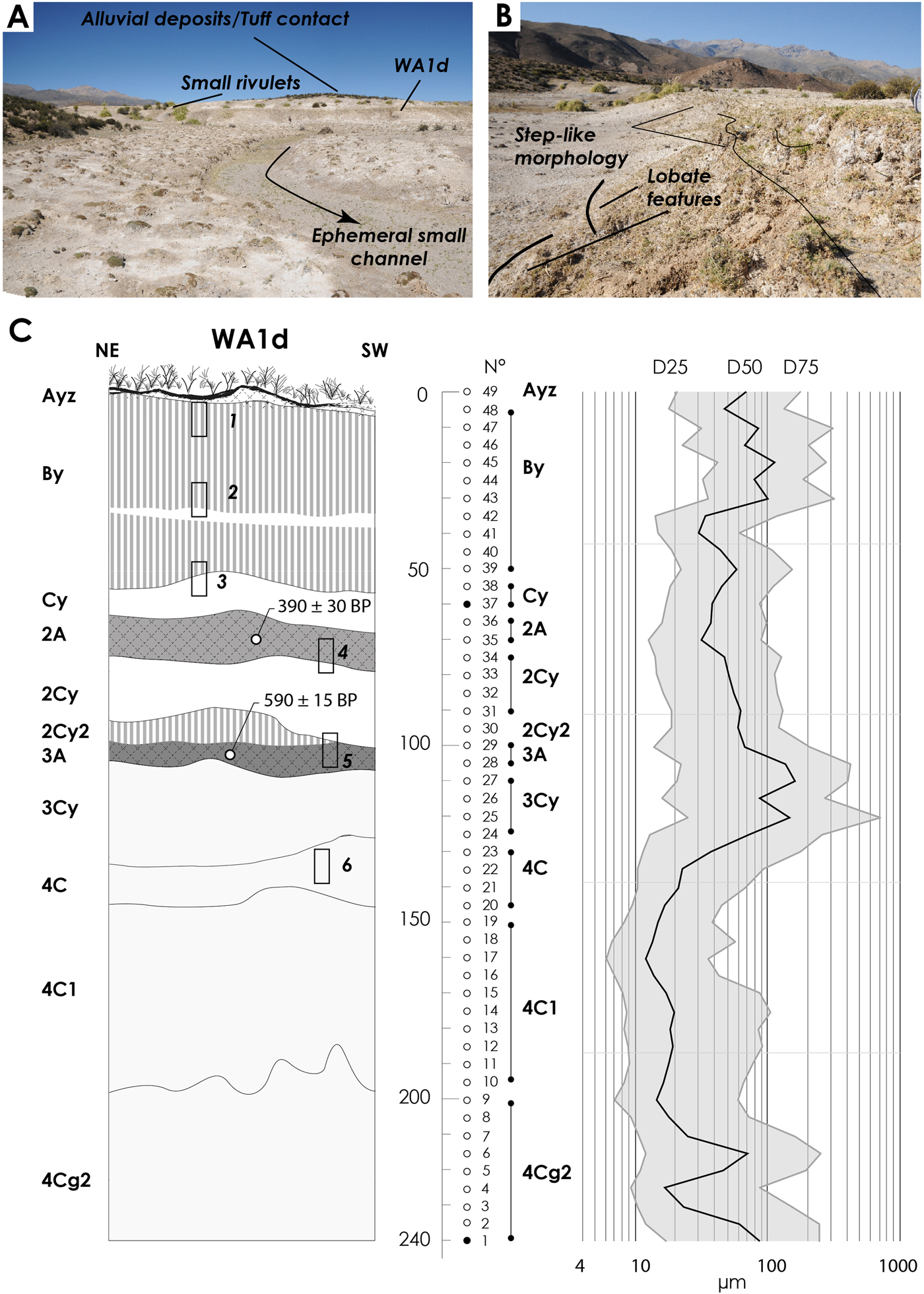
Figure 6. (color online) Wetland Area (WA) 1. (A) Panoramic view facing southeast and the position of the WA1d outcrop. (B) Detailed view of the second step slope, with evidence of crown cracks on the top and lobate features in the footslope. (C) Left: stratigraphic profile with position of micromorphological samples (rectangles). Right: diagram of grain-size variation along the sequence expressed by particle diameters at the 25th, 50th, and 75th percentiles (D25, D50, and D75, respectively). Dots indicate grain-size samples, the black dot indicates the X-Ray Diffraction (DRX) analysis.
Table 1. Radiocarbon ages. Calibration was made using SHCal13 and Calib software. The δ13C values used for correction were not available in the radiocarbon dating report from the Direct AMS laboratory.

Miocene tuff intercalation
In the WA4c section (Fig. 5), the top of the Miocene tuff intercalation is characterized by several sandy C horizons that overlie a pale red uncemented ash horizon with abundant gravels (lapilli, lithic fragments), and unaltered R-horizon patches (Supplementary Fig. 1f). In the WA1d section, the top of the Miocene tuff corresponds to horizons 4C, 4C1, and 4Cg2 (Fig. 6; Supplementary Fig. 1a). The horizons are silty clay sand to silty sand with common gravels (lapilli and lithic fragments), and the grain-size analysis and ternary principal component confirms linearity in the relative sand variation with respect to silt and clay (e.g., Eynatten et al., Reference von Eynatten, Barceló-Vidal and Pawlowsky-Glahn2003; Supplementary Table 2). The micromorphological sample from the 4C1 horizon presented a vughy to channel microstructure, eventually granular (Supplementary Fig. 2). The channel microstructure was related only to the roots inside the groundmass, and not to faunal activity (Supplementary Fig. 2). The mineral fraction is dominated by quartz, K-feldspars and kaolinized plagioclases, and there are small lithics and other volcanic elements, such as shards, pumice, flames, and spherulite. Carbonate impregnation dominates over gypsum pedofeatures. The micromass has a calcitic crystalline undifferentiated b-fabric, with dissolution features such as a lenticular mold of gypsum crystals inside carbonate nodules (Supplementary Fig. 2).
We suggest that, below the paleowetland deposits, there is a saprolith profile resulting from the weathering of the original Miocene tuff intercalation. Layers 4C1, 4C2, and 4Cg2 in the WA1d section are C horizons because they lack clear structure and have few pedogenic features (small roots channels, carbonate, and gypsum concretions). The presence of shards, flames, spherulites, pumice, and lithics confirm a parent material of volcanic origin (Scasso and Limarino, Reference Scasso and Limarino1997; Vaniman, Reference Vaniman and Heicken2006). The grain-size linearity in the ternary principal component analysis of sand to silt and clay and the D25-D50-D70 size trend along the horizons, and are assumed to be the result of glass weathering and the fragmentation of less resistant minerals within the tuff (Dubroeucq et al., Reference Dubroeucq, Geissert and Quantin1998; Yokota and Iwamatsu, Reference Yokota and Iwamatsu2000). Geochemical results reinforce the saprolith interpretation. All the samples from the 4Cg2 horizons are clustered around Si and K values (Supplementary Table 2), which suggest a greater abundance of alterable minerals such as feldspar and muscovite as well as a concentration of unaltered minerals such as quartz. These minerals were recognized in the thin sections (Supplementary Table 1) and the X-ray diffraction analysis (Supplementary Table 2). In the WA4c section, the horizons below Unit A and B are considered to be part of the saprolith and the C horizons are the saprolite, whereas the horizon that hosts patches of relatively unaltered bedrock is the saprorock; the R horizon, which corresponds to a cemented ash with abundant lapilli and lithic fragments, is the unaltered Miocene tuff (Supplementary Fig. 1f).
The gleyey conditions of the lowermost horizons from the WA1d and WA4c sections confirm waterlogging. This is also supported by the detection of pyrite mineral in the X-Ray Diffraction (DRX) samples from 4Cg2 in the WA1d section (Supplementary material Fig. 5), since pyrite forms under anoxic conditions in wetlands (e.g., Vepraskas and Faulkner, Reference Vepraskas, Faulkner, Richardson and Vepraskas2000).
Unit C
Unit C is a histic horizon that varies from 10 to 100 cm thick according to the section. It is not possible to estimate the maximum thickness, as the base of the unit was not observed. In WA2, the horizon is characterized by curved decimetric parallel layers and shows the following alternations: (1) massive muddy sapric to hemic peat layers; and (2) laminated silty to muddy organic layers, with lenticular powdery gypsum parallel to the laminae (Supplementary Fig. 1d). In WA4, the horizon shows an internal sequence of layers that are centimetric to decimetric and are organic or organo-mineral (Supplementary Figure 1e). The top layer of this horizon has an internal lamination, with some laminae made up of lenticular powdery gypsum (Supplementary Fig. 1e). The top of the H horizon is dated within the sections WA2b and WA4b, indicating a maximum age of 7755 to 7300 cal yr BP for Unit C. Unit C is considered to represent a phase of wetland recharge that was sufficient to permanently raise the local water table and peat accumulation.
Unit B
Unit B is 25 to 80 cm thick and is characterized by a succession of silty to sandy silt A horizons separated by silty to sandy silt C horizons (Fig. 5 and 6; Supplementary Figs. 1a–e). Results from the WA1d section indicate that samples from this unit group around the compositional pole of Ca-As, predominantly related to gypsum and calcite (Supplementary Table 2). The most abundant mineral is quartz, followed by kaolinized K-feldspars and plagioclases (Supplementary Table 1). All the horizons contain volcanic elements in the form of lithics, shards, pumice, flames, and spherulites (Supplementary Figs. 3.1–11). Horizons 2A and 3A contain evidence of preserved organic material and charcoal (Supplementary Fig. 3). Horizon 2A contain partially to nearly fully decomposed organic material (Supplementary Fig. 3.15). Horizon 3A has abundant organic material corresponding to: (1) minimally to partially decomposed roots (classes 1 to 3 of Blazejewski et al., Reference Blazejewski, Stolt, Gold and Groffman2005; Supplementary Figs. 3.14, 4.1–2); and (2) phytoliths (Supplementary Figs. 4.3–5). Gypsum pedofeatures, such as infillings, coatings, and nodules dominate in the upper horizons (Ayz-By-Cy; Supplementary Figs. 4.7–11), whereas towards the base of the section there is an increase in carbonate impregnation (Supplementary Fig. 4.6). The micromass includes a gypsum crystallitic undifferentiated b-fabric.
The two paleosols that were investigated in the WA1d section (2A-2Cy-2Cy2 and 3A-3Cy) were formed on parent material of volcanic origin according to the mineral fraction (Supplementary Table1). The basal paleosol (3A and3C) is preliminarily considered as an Epileptic Tephric Histosol (FAO-WRB, 2014). This paleosol has a loose microstructure with abundant tephric material, small decomposed organic fragments in the coarse fraction, and an absence of mesofauna/macrofauna action (Babel, Reference Babel1975; Stolt and Lindbo, Reference Stolt, Lindbo, Stoops, Marcelino and Mees2010). The last two attributes are thought to reflect permanent or semipermanent saturated soil surfaces (Stolt and Lindbo, Reference Stolt, Lindbo, Stoops, Marcelino and Mees2010). It is proposed that the 3A paleosol indicates a period of significant wetland recharge. The lack of a gypsic horizon or significant gypsum concretions associated with the histosol reinforces the notion that this recharge event was sufficient to cause a permanent rise in local water tables. The upper paleosol (2A-2C) is poorly developed and lacks diagnostic horizons. Based on these criteria it is classified as a Tephric Humic Regosol (FAO-WRB, 2014). Weak pedogenesis is demonstrated through a humic horizon with sparsely distributed organic materials consisting of altered fragments and rare charcoals. This paleosol was preserved by an associated episode of ash fall, effectively sealing the 2A and 2C horizons.
Unit B is believed to correspond to a sequence of several tephric humic regosols and/or tephric histosols, representing episodes of permanent rises in local water tables. Paleosols are less organic than the underlying Unit C, and are associated with a younger pedogenesis, indicated by radiocarbon dates. Overall, Unit B accumulated between ca. 7300 and ca. 300 cal yr BP. Thus, the volcanic material composing the paleosols derives from fresh ash-fall inputs from regional volcanic eruptions dating to the Mid–Late Holocene.
Unit A
Unit A is 20 to 80 cm thick and corresponds to the present soil and is characterized by the horizons Ayz, By, and Cy. Analysis from the WA1d section shows that the microstructure is fine monic to crumb from Ayz to Cy (Supplementary Fig. 2). The crumb microstructure does not appear to be related to faunal activity since faunal pedofeatures are not observed. The mineral fraction is dominated by gypsum, followed by kaolinized K-feldspars and plagioclases. All the horizons contain volcanic elements in the form of lithics, shards, pumice, flames, and spherulite (Supplementary Figs. 3.1–11). A compositional biplot of geochemical data indicate that the horizons Ayz to Cy cluster around the Ca-As compositional pole, related primarily to gypsum and calcite according to DR and micromorphology results (Supplementary Table 2). The semiquantitative approach to non-calibrated elements indicate the following results (Supplementary Table 2): (1) Cl is abundant in the Ayz horizon and is related to halite; (2) Gypsum increases from By to Cy, indicated by the presence of sulfur.
Ayz, By, and Cy horizons are interpreted as a Gypsisol, identified through the criteria from micromorphological and geochemical results (FAO-WRB 2014): (1) the earth fraction exceeds 5% gypsum, and reaches 90% in the thin Ayz layer; (2) accumulation of secondary gypsum, as infillings, coatings, nodules, and crystal intergrowths (Poch et al., Reference Poch, Artieda, Herrero, Lebedeva-Verba, Stoops, Marcelino and Mees2010); and (3) gypsum soils of >15 cm thick in arid to semiarid environments (Porta and Herrero, Reference Porta, Herrero and Doublas1990; Casby-Horton et al., Reference Casby-Horton, Herrero, Rolong and Sparks2015). Here, the origin of gypsum is not related to gypsum rocks, which are absent from the area. Ca2+ and sulfate ion SO42− enrichment is predominantly related to inputs from fresh ash fall and the altered ignimbrite. Indeed, volcanic ash deposits with adsorbed volatiles indicate the incorporation of elements such as F, Cl, Ca, Na, and S into the ground (Witham et al., Reference Witham, Oppenheimer and Horwell2005). The increased calcite content towards the base of the gypsisol, present in the WA1d section, suggests that the precipitation of gypsum is related to the capillary rise of a high water table (Birkeland, Reference Birkeland1984). Due to lower solubility, calcium carbonate usually exceeds the gypsum minerals in soils, where the dominant water movement is downward (Casby-Horton et al., Reference Casby-Horton, Herrero, Rolong and Sparks2015). This may also explain the high abundance of halite in the Ayz horizons, which is considerably more soluble in comparison to the gypsum and calcite.
Human settlement
Sector 1 is characterized by several isolated lithic knapping events (basalt, andesite, and smaller amounts of chert). At its center, between WA1 and 3, eight variously sized scattered circular structures were found (Figs. 7 and 8). It is highly likely that these units had a residential function, indicated by the presence of ceramic fragments which are attributed to the “Charcollo” style from the Late Intermediate period (AD 1200–1450; Flewett et al., Reference Flewett, Saintenoy, Sepúlveda, Mosso, Robles, Vega and Gutierrez2016). The size of the structures and visible deposits on the surface indicate the presence of temporary residences. This collection is interpreted to be an “estancia” (small farm) possibly related to pastoralist practices during pre-Inca times (twelfth–fifteenth centuries). The identification of small structures, identified as “windbreaks,” typically built as a temporary shelter by pastoralists or caravaneers (Muñoz and Briones, Reference Muñoz and Briones1996), confirms the hypothesis that this area was used for transitory or short-term occupations. Furthermore, a fragment of a historical turned ceramic recovered within one of the structures indicates use of the structure during more recent times. Two rectangular structures were found in association with cultivation fields close to the edge of the left bank of the Tignamar River, northeast of the main wetland. Nevertheless, these are historical structures with evidence of use during more recent times because of the presence of abandoned cans and ceramic fragments assignable to the post-seventeenth century.

Figure 7. (color online) Archaeological findings identified from the surface within a radius of approximately 800 m from the wetland complex.
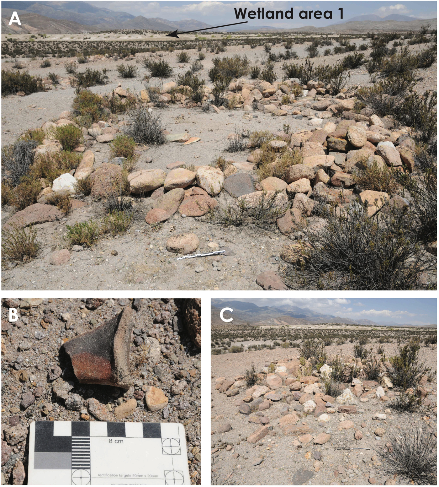
Figure 8. (color online) (A) Large sub-circular archaeological structure identified to be residential and part of a “small farm” located inside the wetland complex from the Late Intermediate or Late Period (cf. Fig. 7 for the location). Note the proximity of Wetland Area 1 in the background. (B) Fragment of a handle from a “Charcollo” ceramic found in the structure identified in A. (C) Small circular structure.
Few lithic flakes were found in Sector 2, corresponding to scattered areas of knapping activity. On the hill overlooking the left bank of the river, two small circular structures were identified, likely residential. Here, several fragments of “Charcollo,” traditional ceramics from the Late Intermediate period (Flewett et al., Reference Flewett, Saintenoy, Sepúlveda, Mosso, Robles, Vega and Gutierrez2016) and flakes of lithic material (andesitic-basalt and chert) were found. This site is interpreted to be an estancia of the same age as the one observed in Sector 1. In Sector 3, some ceramic fragments and scattered lithic events were observed associated with a few habitation structures, with no elements to indicate chronological origin.
In Sector 4, we recorded a considerable amount of scattered ceramics and lithics extending approximately 1.4 km along the hilltop overlooking the right bank of the Tignamar River. Some lithics and ceramics sherds are more concentrated around circular residential structures. Larger circular stone structures were also identified, which were likely used as corrals for domestic camelids. The diagnostic analysis of these ceramics indicate they originate from the Late Intermediate period, contemporary with the structures in Sector 2. Archaeological evidence suggests that this sector represents a pastoral “estancia,” probably occupied by a few inhabitants working in the management of livestock. Some similarities are observed, however, between this site and the settlement found in sector two in terms of site functionality, indicating more intense pastoral activities probably due to the higher water availability. The geology in this sector is characterized by the outcropping of tuff intercalation (Fig. 6, Supplementary Table 2), and NDVI values (≃ 0.2) indicating dense vegetation around this estancia, situated next to a small stream (Fig. 6, Supplementary Table 2). It is likely that the existence of the outcropping tuff was crucial to the existence of the estancia and the wetland. For instance, to the east another small stream was identified that lacks associated archaeological structures and exhibits low NDVI values (≃ 0.07), suggesting that the mere existence of surficial runoff is not sufficient to sustain productive habitats for human activities.
DISCUSSION
Hydrologic interpretations
Mapping, geomorphological, and vegetation data confirm that the wetland complex has an unusual hydrologic setting: the water inflow can neither be related to an alluvial system, nor to seasonal melting of snow patches or spring water. Presently, the only perennial river in the area is the Tignamar, which is fed by streams from the Cordillera, where higher precipitation occurs (Ayala et al., Reference Ayala2003). The high drainage density pattern which typifies the Huaylas Formation, west of the Tignamar River, is inactive. Runoff waters during summer storms are able to produce channelized shallow water flow, but low annual precipitation and high evapotranspiration prevents river formation. Despite the fact, this wetland results from a long-term temporal evolution; an alluvial origin is excluded, since none of the described sections show stratigraphic evidence of fluvial facies within wetlands deposits. Thus, this system is sustained by water input from direct rainfalls; but also through a local perched ground-water system which retains water and feeds the wetlands ecosystem. The first condition is confirmed by the present rainfall (<100 mm), whereas the second condition still needs to be confirmed. A shallow local ground-water system implies a lower boundary in the form of aquitard, deeper ground-water systems emerging at the surface, or an impermeable barrier (Townley, Reference Townley, Dillon and Simmers1998). There are no spring waters (i.e., a deep-seated bedrock aquifer emerging at the surface) in the Tignamar basin, as annual precipitation in the area is not sufficient to feed deep aquifers even if we consider contributions from snowmelt. Meteorological evidence, however, precludes the influence of such factor, as at 3000 m asl there is less than a 20% probability for snowfalls across the tropical-arid Andes (Vuille and Ammann, Reference Vuille and Ammann1997). Hence, the most plausible explanation is the existence of an impermeable barrier.
The local thin tuff intercalation may act as an obstacle to water percolation, especially considering the systematic overlap between the wetland areas and the tuff. According to Garcia et al. (Reference Garcia, Gardeweg, Clavero and Hérail2004), the intercalation is moderate to non-welded. The hydrologic properties of tuffs depend on their welding degree (Smyth and Sharp, Reference Smyth and Sharp2006). Porosity and permeability are high in non-welded tuffs, while their values significantly diminish in densely welded tuffs (Smyth and Sharp, Reference Smyth and Sharp2006). There is no analytical data on the hydrological parameters for the tuff, but results from the stratigraphic sections indicate that it acts as a barrier. In the WA1d section, the 4Cg2 horizon corresponds to the ground water or saturated zone, while the 4C and 4C1 horizons are in the vadose zone. This configuration is only possible under the conditions of the unaltered tuff acting as an aquiclude deeper in the stratigraphy.
In summary, the local hydrological cycle is best described through considering the current precipitation regime, the topographic and geomorphological conditions within the wetland complex, and inferring the existence of a local low permeability barrier (Fig. 9A). During the rainy season (November–March), precipitation percolates through the wetland topsoil until it reaches the tuff barrier or, eventually, the saturated zone above it. The local shallow ground-water table recharges and moves vertically through the surface, facilitating short periods of water saturation near the surface of the soil. Water emerges along small ravines that dissect the wetlands (Fig. 9A), and surface flow has also been observed over small-scale slope breaks inside the wetlands, such as in WA1, 2, and 3. It is probable that runoff generated upstream during intermittent heavy rainstorm events delivers water and sediments to the wetlands. This mechanism is supported by field observations made within some study sections that verify subhorizontal bedding or sandy layers in the upper part of the stratigraphy (Fig. 4 and 5). Throughout the dry season (April–October; Fig. 9B), water tables gradually drop as evapotranspiration rates increase regionally (Houston, Reference Houston2006).

Figure 9. (color online) (A) Synthetic model of current annual cycle in the Humedal La Estrella wetland complex. (B) A model of the geologic cycle of the wetland complex over time. Arrows indicate possible repetitions during the cycle, suggesting that the wetland cycle depends on corresponding changes in the climate.
Paleoclimatic record
The Humedal La Estrella wetland has been functioning since at least the Mid-Holocene. It is clear that there is a low preservation potential in the system, as most of stratigraphic sections show the contact between wetland deposits and the Miocene tuff intercalation. Hence, older paleowetland deposits in the study area have been eroded. A simplified geologic cycle is proposed to describe the wetland evolution (Fig. 10). First, under increased rainfalls, vegetation cover becomes more abundant and the ground-water level permanently rises to the surface, while hydromorphic soils develop. Vegetation cover stabilizes the landform preventing soil erosion and increasing sediment accumulation. Second, the wetland undergoes hydric stress due to longer periods of dry conditions and the vegetation cover simultaneously decreases. Water tables drop dramatically and soils progressively change towards gypsic and/or saline conditions. Third, as the water shortage continues, soils and wetland deposits become fragile. Runoff and aeolian processes gradually erode the wetland deposits until the surface the Miocene tuff substratum is exposed. Finally, the cycle restarts with an increase in precipitations.

Figure 10. (color online) Radiocarbon ages from the paleosol of the Humedal La Estrella Complex, compared with local records from Rech (Reference Rech2001) and with the Chungara Lake record (Bao et al., Reference Bao, Hernández, Sáez, Giralt, Prego, Pueyo, Moreno and Valero-Garcés2015). Holocene limits according to Walker et al. (Reference Walker, Berkelhammer, Björck, Cwynar, Fisher, Long, Lowe, Newnham, Rasmussen and Weiss2012).
How are the six paleosol horizons from the Humedal La Estrella complex related to past variations in hydroclimate conditions? Available paleoclimate data indicate that the western Andean slope (18–25°) underwent variations in the regional hydrological cycle at centennial and millennial timescales over the last 18,000 yr (Latorre et al., Reference Latorre, Betancourt, Rylander and Quade2002, Reference Latorre, Betancourt, Rylander, Quade and Matthei2003, Reference Latorre, Betancourt and Arroyo2006; Rech et al., Reference Rech, Quade and Betancourt2002, Reference Rech, Pigati, Quade and Betancourt2003; Grosjean et al., Reference Grosjean, Núñez and Cartajena2005, Reference Grosjean, Santoro, Thompson, Núñez, Standen, Anderson, Maasch and Sandweiss2007; Maldonado et al., Reference Maldonado, Betancourt, Latorre and Villagran2005; Quade et al., Reference Quade, Rech, Betancourt, Latorre, Quade, Rylander and Fisher2008; Placzek et al., Reference Placzek, Quade, Betancourt, Patchett, Rech, Latorre, Matmon, Holmgren and English2009; Gayo et al., Reference Gayo, Latorre, Jordan, Nester, Estay, Ojeda and Santoro2012a, Reference Gayo, Latorre, Santoro, Maldonado and de Pol-Holz2012b; Díaz et al., Reference Díaz, Frugone, Gutiérrez and Latorre2016; Sáez et al., Reference Sáez, Godfrey, Herrera, Chong and Pueyo2016; de Porras et al., Reference de Porras, Maldonado, Pol-Holz, Latorre and Betancourt2017; Pfeiffer et al., Reference Pfeiffer, Latorre, Santoro, Gayo, Rojas, Carrevedo and McRostie2018). In this context, the record of paleosol formation within the wetland system appear to be discontinuous, identifying four episodes of hydroclimate anomalies at 7755–7300, 1270 (AD 680), 545 (AD 1400), and 400–300 cal yr BP (AD 1550–1650; Table 1).
Many paleoclimate records show evidence of widespread arid conditions in the region since 8500 cal yr BP (Baied and Wheeler, Reference Baied and Wheeler1993; Schwalb et al., Reference Schwalb, Burns and Kelts1999; Latorre et al., Reference Latorre, Betancourt and Arroyo2006; Moreno et al., Reference Moreno, Giralt, Valero-Garcés, Sáez, Bao, Prego, Pueyo, González-Sampériz and Taberner2007, Reference Moreno, Santoro and Latorre2009; Quade et al., Reference Quade, Rech, Betancourt, Latorre, Quade, Rylander and Fisher2008; Pueyo et al., Reference Pueyo, Sáez, Giralt, Valero-Garcés, Moreno, Bao, Schwalb, Herrera, Klosowska and Taberner2011; Hernandez et al., Reference Hernández, Bao, Giralt, Sáez, Leng, Barker, Kendrick and Sloane2013). This prolonged dry spell was interrupted by a brief but prominent wet interlude that sharply coincides with the chronology for the top of Unit C (7755–7300 cal yr BP). Either at the WA2b or WA4b section, the H horizon of the Unit C is covered by silty-clayey sediments of Unit B (i.e., C horizon), suggesting that such episode of increased rainfalls ceased after 7300 cal yr BP. This wet-dry cycle in our paleowetland record is consistent either in chronology or direction with changes inferred at 9000–7000 cal yr BP from paleohydrological proxies from the high-elevation Chungara Lake (50 km north of our study site; Fig. 10; Moreno et al., Reference Moreno, Giralt, Valero-Garcés, Sáez, Bao, Prego, Pueyo, González-Sampériz and Taberner2007, Reference Moreno, Santoro and Latorre2009; Pueyo et al., Reference Pueyo, Sáez, Giralt, Valero-Garcés, Moreno, Bao, Schwalb, Herrera, Klosowska and Taberner2011; Bao et al., Reference Bao, Hernández, Sáez, Giralt, Prego, Pueyo, Moreno and Valero-Garcés2015). Similarly, it correlates with slightly wetter conditions at 7330–6720 cal yr BP recorded in rodent middens from the Río Salado basin (22°S; Latorre et al., Reference Latorre, Betancourt and Arroyo2006). In comparison to paleowetlands located close to our system, the Mid-Holocene positive hydroclimate anomaly detected in the Humedal La Estrella does not match in timing with increased ground-water discharge events detected at Quebrada la Higuera and Zapahuira (Rech, Reference Rech2001). Indeed, periods of increased rainfalls in these ground- water-fed wetlands are manifested during the Pleistocene-Holocene transition (13,800–10,200 cal yr BP), at the interval 5900–4800 cal yr BP, and then after 3000 cal yr BP (Rech, Reference Rech2001).
Our two radiocarbon ages on WA2b and WA4b sections define a maximum age for the Mid-Holocene wet phase recorded at Humedal La Estrella complex. This implies that our chronology for this event is limited and requires expansion to evaluate any relationship between our horizon H with other late Pleistocene paleowetland sequences described for the Atacama Desert (Rech, Reference Rech2001; Rech et al., Reference Rech, Quade and Betancourt2002, Reference Rech, Pigati, Quade and Betancourt2003; Quade et al., Reference Quade, Rech, Betancourt, Latorre, Quade, Rylander and Fisher2008). Due to the massive thickness of the H horizon (>100 cm), it is possible that this deposit may be paleoclimatically and chronologically related to the Unit B3 defined for wetland deposits dated at 12,700–9700 cal yr BP in other locations in the Atacama (18–25°S; Rech, Reference Rech2001; Rech et al., Reference Rech, Quade and Betancourt2002, Reference Rech, Pigati, Quade and Betancourt2003; Quade et al., Reference Quade, Rech, Betancourt, Latorre, Quade, Rylander and Fisher2008). In deposits preserved within Quebrada la Higuera, Rech (Reference Rech2001) identifies that the maximum age for the Unit B3 is around 10,200 cal yr BP, discarding a potentially “contaminated” youngest age of 9450 cal yr BP. Considering this information, the minimum age for Unit C may be dated back to the latest Pleistocene, indicating the accumulation of organic horizon during the second stage (11,700–8500 cal yr BP) of the “Central Andean Pluvial Event” (CAPE), the most prominent wet interlude recorded regionally over the last 18,000 yr (Latorre et al., Reference Latorre, Betancourt and Arroyo2006; Quade et al., Reference Quade, Rech, Betancourt, Latorre, Quade, Rylander and Fisher2008; Placzek et al., Reference Placzek, Quade, Betancourt, Patchett, Rech, Latorre, Matmon, Holmgren and English2009; Gayo et al., Reference Gayo, Latorre, Jordan, Nester, Estay, Ojeda and Santoro2012a; Sáez et al., Reference Sáez, Godfrey, Herrera, Chong and Pueyo2016; de Porras et al., Reference de Porras, Maldonado, Pol-Holz, Latorre and Betancourt2017). The wet phase documented in the Humedal La Estrella complex between 7755–7300 cal yr BP is also present in Chungara Lake (Fig. 9). Hence, it is likely that the CAPE II stage extended beyond 8500 cal yr BP at 18°S. Spatiotemporal differences in the expression of CAPE stages across the western Andean flank are commonly observed, reflecting the complex interaction of different climate regimes controlling the hydrological cycle over an area extending more than 1000 km (Quade et al., Reference Quade, Rech, Betancourt, Latorre, Quade, Rylander and Fisher2008; Placzek et al., Reference Placzek, Quade, Betancourt, Patchett, Rech, Latorre, Matmon, Holmgren and English2009; Gayo et al., Reference Gayo, Latorre, Jordan, Nester, Estay, Ojeda and Santoro2012a; Sáez et al., Reference Sáez, Godfrey, Herrera, Chong and Pueyo2016; de Porras et al., Reference de Porras, Maldonado, Pol-Holz, Latorre and Betancourt2017; Pfeiffer et al., Reference Pfeiffer, Latorre, Santoro, Gayo, Rojas, Carrevedo and McRostie2018).
Alternatively, the accumulation of the H horizon may indicate brief but frequent wet pulses that followed the CAPE II stage and that the extreme thickness of the organic deposit in the Unit C is a result of high sedimentation rates. The majority of paleowetland deposits from the Atacama Desert do not present these conditions (Rech Reference Rech2001; Rech et al., Reference Rech, Quade and Betancourt2002, Reference Rech, Pigati, Quade and Betancourt2003; Quade et al., Reference Quade, Rech, Betancourt, Latorre, Quade, Rylander and Fisher2008), probably due to clear differences in the recharge mechanism accounting for ground-water-fed systems and our wetland sourced by direct rainfalls.
Our record does not reproduce the wet phase detected regionally during the so-called Medieval Climate Anomaly (1050–680 cal yr BP; Maldonado et al., Reference Maldonado, Betancourt, Latorre and Villagran2005; Gayo et al., Reference Gayo, Latorre, Santoro, Maldonado and de Pol-Holz2012b; Morales et al., Reference Morales, Christie, Villalba, Argollo, Pacajes, Silva, Alvarez, Llancabure and Soliz Gamboa2012; Mujica et al., Reference Mujica, Latorre, Maldonado, González-Silvestre, Pinto, de Pol-Holz and Santoro2014; Sáez et al., Reference Sáez, Godfrey, Herrera, Chong and Pueyo2016). Still, Late Holocene paleosol formation events in our system are in overall agreement with other centennial and decadal scale positive hydroclimate anomalies. The paleosol formation in the Humedal La Estrella dated at 1270 cal yr BP coincides with a period of enhanced rainfalls (1400–1200 cal yr BP) inferred from rodent middens collected along the Atacama between 18° and 25°S (Latorre et al., Reference Latorre, Betancourt, Rylander and Quade2002, Reference Latorre, Betancourt, Rylander, Quade and Matthei2003, Reference Latorre, Betancourt and Arroyo2006; Maldonado et al., Reference Maldonado, Betancourt, Latorre and Villagran2005; Holmgren et al., Reference Holmgren, Rosello, Latorre and Betancourt2008). Furthermore, it is practically synchronous with lacustrine high stands documented in the Chungara and Aricota basins at 1610–1300 cal yr BP (Placzek et al., Reference Placzek, Quade and Betancourt2001; Bao et al., Reference Bao, Hernández, Sáez, Giralt, Prego, Pueyo, Moreno and Valero-Garcés2015), whereas the accumulation of organic horizons at 545 and 400–300 cal yr BP correlate well with multi-decadal wet pulses that interrupted the negative precipitation anomaly detected regionally during the Little Ice Age (Morales et al., Reference Morales, Christie, Villalba, Argollo, Pacajes, Silva, Alvarez, Llancabure and Soliz Gamboa2012; Mujica et al., Reference Mujica, Latorre, Maldonado, González-Silvestre, Pinto, de Pol-Holz and Santoro2014).
The apparent discrepancy in the timing and duration of positive hydroclimate anomalies recorded in the Humedal La Estrella complex versus ground-water-sourced wetlands from the western Andean flank is not evident during the Late Holocene. Paleowetland deposits within canyons or springs suggest a concomitant rise in water tables around 2000–1300 and 800–400 cal yr BP (Rech, Reference Rech2001, Rech et al., Reference Rech, Quade and Betancourt2002, Reference Rech, Pigati, Quade and Betancourt2003; Nester et al., Reference Nester, Gayó, Latorre, Jordan and Blanco2007; Gayo et al., Reference Gayo, Latorre, Santoro, Maldonado and de Pol-Holz2012b; Sáez et al., Reference Sáez, Godfrey, Herrera, Chong and Pueyo2016). This indicates that organic horizons from 1270 and 545–300 cal yr BP are coeval to Units D1 (2000–1300 cal yr BP) and D2 (800–400 cal yr BP), identified in sequences from the northern and central Atacama Desert (Rech Reference Rech2001; Rech et al., Reference Rech, Quade and Betancourt2002, Reference Rech, Pigati, Quade and Betancourt2003), respectively. This correlation needs to be to be evaluated, however, with further radiocarbon determinations, as it relies on a single date on sediments from the top of the thick organic horizon (Table 1, sample D-AMS 027602).
Implications for regional human settlement
A recent study on settlement patterns since the twelfth century AD in the Arica Precordillera identifies several villages that were established near to agricultural productive areas (Saintenoy et al., Reference Saintenoy, Ajata, Romero and Sepulveda2017). Furthermore, the authors emphasized a strong farming imprint around the three previously identified large agricultural localities (Muñoz Ovalle, Reference Muñoz Ovalle2005). Evidence of small settlements with 2 to 5 circular structures of less than 7 m in diameter were identified (Saintenoy et al., Reference Saintenoy, Ajata, Romero and Sepulveda2017), linked both to agricultural practices and livestock. Thus, the findings from the wetland partially portrays the settlement pattern in this area during the late pre-Hispanic period, specifically during the Late Intermediate period between the twelfth and the fifteenth centuries AD. Moreover, specific links exist with the available water resources from possible perched wetland areas, indicating a complementary seasonal relationship with the Tignamar River. Indeed, the four sectors present findings within areas that do not relate to rivers, but present favorable conditions to the development of perched wetland systems, similar to the results described in this article. Further studies are required to verify this hypothesis.
Although the settlements seem to correlate with the youngest wetland paleosols, the possibility that the correlation existed in a previous period of regional pre-Hispanic settlement should be considered. Evidence of previous settlement suggested by the recent discovery of occupations attributed to the Early (10,500–8500 years cal BP) and Late (6000–3700 years cal BP) phases of the Archaic period in a radius of 1–5 km around the wetland (Sepúlveda et al., Reference Sepúlveda, Cornejo, Osorio, Sitzia, Saintenoy and Espinoza2017a). Several archaeological sites were identified surrounding the wetlands corresponding to shelters with and without rock art and open-air camps. The evidence from these sites demonstrates not only a variety of daily activities but also different ways of occupying space (Sepúlveda et al., Reference Sepúlveda, Cornejo, Osorio, Sitzia, Saintenoy and Espinoza2017a, Reference Sepúlveda, Saintenoy, Cornejo, Dudognon, Espinoza, Guerrero-Bueno and Cerrillo-Cuencab, Reference Sepúlveda, Cornejo, Osorio, Uribe and Llanos2018). It is likely that, in the wetland complex investigated in this study, more recent occupations have diminished the visibility of previous older ones and prevent their identification during surface surveys. Considering the Archaic evidence presented so far, however, it seems probable that hunter-gatherer groups have traveled through the sector as part of their mobility-subsistence system, thus taking advantage of the resources available around these wetlands.
As noted previously, wetlands are attractive areas for the human settlement, especially in deserts areas. Nicholas (Reference Nicholas1998) stresses that wetlands played a significant role for hunter-gatherer groups because of their ecological characteristics. The presence of wetland-related vestiges from hunter-gatherer groups provide useful information on diverse aspects such as mobility, population density, social stratification, and local cultural and economic diversity. In the Atacama Desert, multiple studies have revealed the importance of wetland areas for hunter-gatherers (e.g., Grosjean et al., Reference Grosjean, Núñez and Cartajena2005; Latorre et al., 2013, Núñez et al., Reference Núñez, Cartajena and Grosjean2013). Nonetheless, all these examples are related to wetlands connected to large water-fed systems, like rivers or springs outcropping at the base of Andean slopes or through fault systems. By contrast, ours study appears to be the first to investigate the possible role of ephemeral wetlands, i.e., unpredictable systems that are intermittently inundated with water may dry on an annual basis (Calhoun et al., Reference Calhoun, Mushet, Bell, Boix, Fitzsimons and Isselin-Nondedeu2017). In desert areas that lie on the transition between hyperarid desert and semiarid desert, such as the one in this study, this kind of wetland could have been a valuable resource for highly mobile groups such as hunter-gatherers. This study confirms the existence of wetland systems fed directly by rainfalls in the Atacama Desert, and it will be valuable to continue exploring this matter in the future.
CONCLUSION
We used geomorphological, pedostratigraphic, geochemical, and contemporary vegetation data to understand the formation of the Humedal La Estrella complex, a high-elevation (3300 m asl) wetland located in the Atacama Desert of northern Chile. The site is classified as a flat “perched” wetland based on topographic and hydrogeologic criteria. This type of wetland has not been previously documented in the Atacama Desert, thus this is a first description of its current functioning and also uses general knowledge to deepen the understanding of paleowetland deposits. Two main factors control the functioning of this wetland: (1) gain of water from direct precipitations; and (2) an impermeable layer corresponding to a Miocene tuff located close to the surface, which allows for the existence of local shallow ground water. The ground-water table recharges during the rainy season (November–March) and moves vertically towards the surface, enabling saturation near the surface of the soil.
The Humedal La Estrella complex consists of four wetland areas with a similar pedostratigraphic sequence, consisting of three units (Units A, B, and C) of paleowetland deposits which overlie a saprolith (i.e., altered and unaltered parts of the Miocene tuff). Evidence from all studied sections suggest that this paleowetland sequence spans the entire Holocene. Paleosol horizons are identified in Units B and C, which are considered to reflect periods of enhanced precipitations on a regional scale. Unit C corresponds to a thick H horizon, with the top layer dated from between 7755 and 7300 cal yr BP. We propose two alternative explanations for the this paleosol formation: (1) it was accumulated during the second stage of the CAPE II, which, in turn, extended beyond 8500 cal yr BP at 18°S; or (2) it represents a brief pulse that followed the CAPE II, which is also replicated in the Chungara lacustrine records (Moreno et al., Reference Moreno, Giralt, Valero-Garcés, Sáez, Bao, Prego, Pueyo, González-Sampériz and Taberner2007, Reference Moreno, Santoro and Latorre2009; Pueyo et al., Reference Pueyo, Sáez, Giralt, Valero-Garcés, Moreno, Bao, Schwalb, Herrera, Klosowska and Taberner2011; Bao et al., Reference Bao, Hernández, Sáez, Giralt, Prego, Pueyo, Moreno and Valero-Garcés2015) as well as in rodent-middens series from the Río Salado basin (Latorre et al., Reference Latorre, Betancourt and Arroyo2006). Unit B consists of several paleosols that are dated back to the Late Holocene. In general, these are consistent with wetter interludes recorded in other hydroclimate reconstructions for the Atacama Desert, specifically at ca. 1270, 545, and 410–300 cal yr BP. The synchronicity with other records for changes in hydroclimate conditions in the Atacama implies that paleosols preserved at the Humedal La Estrella represent feasible proxies for past variations in local and regional hydrological cycle.
Our results indicate that this wetland system played a pivotal role on local human settlement patterns since pre-Hispanic times. Indeed, we verify that the area was occupied by pastoralist groups that established “estancias” between the twelfth and fifteenth centuries. Apparently, these small farms were related to the La Estrella wetland complex and/or to other equivalent and closer environment that developed as hydrological local budgets increased locally (i.e., amplified precipitations) providing valuable resources such as freshwater and fodder. Likely, this kind of system functioned during the Early and Mid-Holocene and, in turn, affected Archaic hunter-gatherer occupation patterns in highland and/or low-elevation areas of the Atacama.
ACKNOWLEDGMENTS
This work was supported by the Chilean government projects FONDECYT 3150664, 1130808, 11150210, the Proyecto UTA-Mayor de Investigación Científica y Tecnológica 2017 8766-17, and the FB-0002-2014 to CAPES. EMG and RDH acknowledge the support of FONDAP 15110009 to (CR)2. We would additionally like to thank José Carcamo, Francisco Espinosa, Zaray Guerrero, Jorge Molina, and Ximena Power for providing assistance during fieldwork; Pilar Babot for assisting in the identification of phytoliths; Alicia Marticorena for assisting with the identification of plants; and Federico Luebert for providing critical bibliographic references.
SUPPLEMENTARY MATERIAL
The supplementary material for this article can be found at https://doi.org/10.1017/qua.2018.144