

Introduction
Grain production potential (GrPP) is the maximum production that can be achieved in 1 year by land use under the limitations of climate conditions and in the absence of pests, diseases and other factors (Liu et al., Reference Liu, Xu and Chen2015; Xu et al., Reference Xu, Wang, Cai, Wang, Liu and Wang2017). Research on GrPP is of great significance for making full use of land and climate resources to optimize food production (Quaye et al., Reference Quaye, Hall and Luzadis2010; Lobell et al., Reference Lobell, Schlenker and Costa-Roberts2011; Peltonen-Sainio et al., Reference Peltonen-Sainio, Jauhiainen and Lehtonen2016; Xu et al., Reference Xu, Wang, Cai, Wang, Liu and Wang2017). Climate resources, such as light, temperature, water and heat, restrict crop growth and development (Schmidhuber and Tubiello, Reference Schmidhuber and Tubiello2007; Van Wart et al., Reference Van Wart, van Bussel, Wolf, Licker, Grassini, Nelson, Boogaard, Gerber, Mueller, Claessens, van Ittersum and Cassman2013; Anwar et al., Reference Anwar, Liu, Farquharson, Macadam, Abadi, Finlayson, Wang and Ramilan2015). Thus, climate change would inevitably lead to increases or reductions in GrPP. Land use change directly alters the quantity, quality and spatial distribution pattern of land resources, and in combination with climate effects determine changes in GrPP (Zhang et al., Reference Zhang, Zhang, Zhang, He, Zhang, Wu and Kong2009; Bagley et al., Reference Bagley, Desai, Dirmeyer and Foley2012).
Global climate change, characterized by climate warming, has a profound impact on both natural and socio-economic systems (Wheeler and von Braun, Reference Wheeler and von Braun2013; IPCC, 2014; Qin, Reference Qin2014). Different climate elements not only provide material and energy for crop growth, but are also important limiting factors for the effective implementation of agricultural technology (Lobell and Asner, Reference Lobell and Asner2003; Ciais et al., Reference Ciais, Reichstein, Viovy, Granier, Ogée, Allard, Aubinet, Buchmann, Bernhofer, Carrara, Chevallier, De Noblet, Friend, Friedlingstein, Grünwald, Heinesch, Keronen, Knohl, Krinner, Loustau, Manca, Matteucci, Miglietta, Ourcival, Papale, Pilegaard, Rambal, Seufert, Soussana, Sanz, Schulze, Vesala and Valentini2005; Lobell and Gourdji, Reference Lobell and Gourdji2012; Chourghal et al., Reference Chourghal, Lhomme, Huard and Aidaoui2016). Therefore, agricultural systems are some of the most sensitive systems to climate change (Thornton et al., Reference Thornton, Jones, Alagarswamy, Andresen and Herrero2010; Manandhar et al., Reference Manandhar, Vogt, Perret and Kazama2011; Harrison et al., Reference Harrison, Cullen and Rawnsley2016; Lieffering et al., Reference Lieffering, Newton, Vibart and Li2016). Climate change can lead to changes in the quantity and quality of agricultural climate resources related to food production (Bindi et al., Reference Bindi, Palosuo, Trnka and Semenov2015; Mereu et al., Reference Mereu, Carboni, Gallo, Cervigni and Spano2015; Anandhi et al., Reference Anandhi, Steiner and Bailey2016; Dawson et al., Reference Dawson, Perryman and Osborne2016). Changes in the quantity and pattern of various agricultural climate resources affect the agricultural production potential, the agricultural production layout and the cropping system, which have serious impacts on global food production and security (Supit et al., Reference Supit, van Diepen, de Wit, Kabat, Baruth and Ludwig2010; Tirado et al., Reference Tirado, Clarke, Jaykus, McQuatters-Gollop and Frank2010; Chakraborty and Newton, Reference Chakraborty and Newton2011). The impact of climate change on agricultural production, food security, rural socio-economics and farmer income have become an important focus of climate change research (Tingem et al., Reference Tingem, Rivington, Bellocchi, Azam-Ali and Colls2008; Lake et al., Reference Lake, Hooper, Abdelhamid, Bentham, Boxall, Draper, Fairweather-Tait, Hulme, Hunter, Nichols and Waldron2012; Shindell et al., Reference Shindell, Kuylenstierna, Vignati, van Dingenen, Amann, Klimont, Anenberg, Muller, Janssens-Maenhout, Raes, Schwartz, Faluvegi, Pozzoli, Kupiainen, Höglund-Isaksson, Emberson, Streets, Ramanathan, Hicks, Oanh, Milly, Williams, Demkine and Fowler2012; Bobojonov and Aw-Hassan, Reference Bobojonov and Aw-Hassan2014; Reidsma et al., Reference Reidsma, Bakker, Kanellopoulos, Alam, Paas, Kros and de Vries2015; Connolly-Boutin and Smit, Reference Connolly-Boutin and Smit2016).
Furthermore, climate change also contributes indirectly to GrPP by affecting land use change (Lobell and Asner, Reference Lobell and Asner2003; Yuan et al., Reference Yuan, Guo, Ye and Zhao2012; Zhong et al., Reference Zhong, Liu, Xu and You2012; Mishra et al., Reference Mishra, Singh, Raghuwanshi, Chatterjee and Froebrich2013; Yang et al., Reference Yang, Shen and Li2015). Over the past 20 years, how ecosystem service supply can be affected by the coupled human-environment system, at different scales and contexts, has been at the forefront of global change research, promoting the study of ecological and environmental effects of land use change (Fischer and Sun, Reference Fischer and Sun2001; Fischer et al., Reference Fischer, Teixeira, Hizsnyik, van Velthuizen, Zuurbier and van de Vooren2008; Gaál et al., Reference Gaál, Quiroga and Fernandez- Haddad2014). The impact of land use change on GrPP has also become an important research topic in its own right (Wang et al., Reference Wang, Wang, Yang, Zhang and Yin2012; Betts et al., Reference Betts, Golding, Gonzalez, Gornall, Kahana, Kay, Mitchell and Wiltshire2013; Liu et al., Reference Liu, Xu and Chen2015). However, climate and land use change have significant regional differences, which inevitably leads to variations in GrPP changes in different regions (such as traditional agricultural areas, agro-pastoral ecotone and ecologically fragile areas) and there is an urgent need for effective response measures and control strategies that account for different agricultural types and agricultural production methods (Manandhar et al., Reference Manandhar, Vogt, Perret and Kazama2011; Zhang et al., Reference Zhang, Zhao, Yin, Liu, Xue, Wang, Pu, Lal and Chen2015; Chun et al., Reference Chun, Li, Wang, Lee, Lee, Horstmann, Park, Veasna, Vanndy, Pros and Vang2016; Touch et al., Reference Touch, Martin, Scott, Cowie and Liu2016; Thamo et al., Reference Thamo, Addai, Pannell, Robertson, Thomas and Young2017; Stöckle et al., Reference Stöckle, Higgins, Nelson, Abatzoglou, Huggins, Pan, Karimi, Antle, Eigenbrode and Brooks2018).
At present, internationally recognized and mature GrPP estimation models can be summarized under three categories: (1) potential decay methods, such as the environment factor correction model (Liu et al., Reference Liu, Xu, Zhuang and Gao2005); (2) climate factor synthesis methods, i.e. empirical methods, including the global agro-ecological zone (GAEZ) model (Fischer et al., Reference Fischer, Velthuizen, Shah and Nachtergaele2002) and the Wageningen method (van Ittersum et al., Reference van Ittersum, Leffelaar, van Keulen, Kropff, Bastiaans and Goudriaan2003); and (3) crop growth process simulation methods, such as the CERES model (Jones and Thornton, Reference Jones and Thornton2003; Yun, Reference Yun2003), the EPIC model (Priya and Shibasaki, Reference Priya and Shibasaki2001) and the CROPGRO model (Basso et al., Reference Basso, Ritchie, Pierce, Braga and Jones2001; Batchelor et al., Reference Batchelor, Basso and Paz2002). The GAEZ method comprehensively considers climatic factors (including precipitation, maximum temperature, minimum temperature, solar radiation, relative humidity, wind speed and wet day frequency), length of the growth period and moisture requirement at different growth stages according to the characteristics of the planted crops (Tian et al., Reference Tian, Zhong, Sun, Fischer, van Velthuizen and Liang2014; Liu et al., Reference Liu, Xu and Chen2015). Therefore, the GAEZ model is widely used throughout the world, especially in developing countries, because of the availability of basic data, the simplicity of the calculation process and because the results can reflect the multi-year average status of regional GrPP accurately (Seo, Reference Seo2014).
In the current paper, Shaanxi Province with its six geographical units (Arid Sandy area, Loess Plateau, Guanzhong Plain, Qinling Mountains, Hanjiang Basin and Daba Mountains) was selected as the research object to analyse trends in GrPP and to identify the main influencing factors in different regions by using the GAEZ model. Studying the trends and influencing factors of GrPP change in different geographical units could assess the coordination patterns and differences between GrPP and agricultural climate resources and land use. Furthermore, it will help agricultural production to seek profits and avoid harm whilst making full and rational use of climate and land resources to ensure food security.
Materials and methods
Study area
Shaanxi Province is located in the north-west of China (105°29′–111°15′E,31°42′–39°35′N) and its total area is about 2 05 700 km2. Shaanxi Province belongs to the zone of the continental monsoon climate and also stretches into both the North Temperate Zone and the Semi-tropic Zone; the multi-year average precipitation is 576.9 mm, the average annual temperature is about 13.0 °C and the frost-free period is about 218 days. Planted crops are mainly summer maize and winter wheat; these two crops account for about 0.80 of total grain production in Shaanxi Province. Shaanxi Province is divided into six geographical units: Arid Sandy area, Loess Plateau, Guanzhong Plain, Qinling Mountains, Hanjiang Basin and Daba Mountains (Fig. 1).

Fig. 1. Study area and the six geographical units.
Data sources
The data used in the current study include land use, climate, soil, topographic and socio-economic data (mainly referring to actual grain yield). Land use data (2000/2005/2010/2015) was obtained from the 1: 1 million land use database of the Resources and Environment Data Cloud Platform of the Chinese Academy of Sciences (http://www.resdc.cn/). Climate data were downloaded from the National Meteorological Information Centre (http://data.cma.cn/site/index.html), including monthly precipitation (Pre), average maximum temperature (Tmx), average minimum temperature (Tmn), wind speed (Wnd), relative humidity (Rhu), wet day frequency (Wdf) and solar radiation (Rad) from 2000 to 2015. The meteorological data were interpolated using the Anusplin interpolation model (Hutchinson, Reference Hutchinson2001), which is based on the smooth spline function and takes into account the influence of terrain and other factors. Therefore, the interpolation results are more accurate than those of the general interpolation method. Soil data were obtained from the 1: 1 million soil database of the Resources and Environment Data Cloud Platform of the Chinese Academy of Sciences (http://www.resdc.cn/), including soil type, composition, depth and water holding capacity, amongst other properties. Terrain data were derived from the Digital Elevation Model (DEM) data provided by the Shuttle Radar Topography Mission (SRTM) system (https://dds.cr.usgs.gov/srtm/). The SRTM-DEM used in the current study has a spatial resolution of 90 m. Socio-economic data were obtained from the Shaanxi Province Statistical Yearbooks (Shaanxi Provincial Bureau of Statistics, 2000–2015).
Global agro-ecological zone model
The GAEZ model was used to estimate the GrPP: this is a large-scale land productivity model developed jointly by the Food and Agriculture Organization of the United Nations (FAO) and the International Institute for Applied Systems Analysis (IIASA). It firstly estimates the climatological suitability of a crop based on climatic conditions, then calculates GrPP by using a progressively limiting method (Fig. 2; Fischer and Sun, Reference Fischer and Sun2001; Fischer et al., Reference Fischer, Velthuizen, Shah and Nachtergaele2002, Reference Fischer, Teixeira, Hizsnyik, van Velthuizen, Zuurbier and van de Vooren2008). For the detailed computation process of GAEZ, please refer to IIASA/FAO (2010). Applicability of the GAEZ model in China has been verified extensively with relevant parameters revised (Zhong et al., Reference Zhong, Liu, Xu and You2012; Liu et al., Reference Liu, Xu and Chen2015; Xu et al., Reference Xu, Wang, Cai, Wang, Liu and Wang2017).

Fig. 2. Model structure of the Global agro-ecological zone (GAEZ).
Statistics data on actual grain production showed that the yield of summer maize and winter wheat accounts for > 0.80 of the total grain production in Shaanxi Province. Considering that the planting system in Shaanxi Province is an annual double-crop rotation system (summer maize and winter wheat), production potentials of summer maize and winter wheat are modelled individually using GAEZ. Grain production potential used in the current study is the sum of the production potential of summer maize and winter wheat. The GAEZ model runs used in the current study modelled GrPP under rain-fed conditions.
The study area was divided into a number of grid cells with a size of 1 km2 for the convenience of spatial analysis. For a certain grid cell, the GrPP (y i, kg/ha/year; since the focus is on annual quantities, for ease of description, the unit of GrPP is henceforth abbreviated as kg/ha in the following sections) was calculated as follows:
 $$y_{\rm i} = Q_{\rm i} \times P_{\rm i}$$
 $$Y = \sum y_{\rm i} \times a_{\rm i}$$
where Q i is the land production potential simulated by GAEZ in the grid cell, P i is the percentage of cultivated land within the grid cell, Y is the total GrPP (kg) of the study area and a i is the area of grid cell i.
The GrPP change in a certain grid cell (Δy i) depends on the change in land production potential (Q it-Q i0) caused by climate change, the change in the percentage of cultivated land (P it-P i0) caused by land use change and the additional coupling effects of climate change and land use change:
 $$\Delta y_{\rm i} = y_{{\rm it}}-y_{{\rm i0}} = C_{\rm i} + L_{\rm i} + ACE_{\rm i}$$
 $$C_{\rm i} = \lpar {Q_{{\rm it}}-Q_{{\rm i0}}} \rpar \times P_{{\rm i0}}$$
 $$L_{\rm i} = Q_{{\rm i0}} \times \lpar {P_{{\rm it}}-P_{{\rm i0}}} \rpar $$
 $$ACE_{\rm i} = \lpar {Q_{{\rm it}}-Q_{{\rm i0}}} \rpar \times \lpar {P_{{\rm it}}-P_{{\rm i0}}} \rpar $$
 $$C = \displaystyle{{\sum C_{\rm i} \times a_{\rm i}} \over {\sum a_{\rm i}}};\,\; L = \displaystyle{{\sum L_{\rm i} \times a_{\rm i}} \over {\sum a_{\rm i}}};\,\; {\rm ACE} = \displaystyle{{\sum ACE_{\rm i} \times a_{\rm i}} \over {\sum a_{\rm i}}}$$
 $$\Delta Y = C + L + {\rm ACE}$$
where C i is the GrPP change in a certain grid cell caused by climate change in the absence of land use change; L i is the GrPP change in a certain grid cell caused by land use change in the absence of climate change; ACEi is the additional coupling effect in a certain grid cell of climate change and land use change; ΔY is the total change in GrPP for a given region (set of grid cells) caused by both climate change and land use change; L is the total GrPP change caused by land use change independently; C is the total GrPP change caused by climate change independently; and ACE is the GrPP change caused by additional coupling effects of climate change and land use change. The subscript 0 indicates the initial value and t indicates the value after change.
Results
Model validation
In order to verify the model simulation results, the correlation between actual grain yield from the Shaanxi Province Statistical Yearbooks (Shaanxi Provincial Bureau of Statistics, 2000–2015) and GrPP per year as simulated by GAEZ in each region of Shaanxi Province was analysed (Fig. 3). The results showed that the two were significantly correlated (P < 0.01, r = 0.619). Therefore, the simulation results can be considered to realistically reflect the temporal-spatial changes in GrPP with a high degree of credibility.

Fig. 3. Correlation analysis between grain production potential (GrPP) and actual yield in Shaanxi Province.
Grain production potential change in Shaanxi Province
Total GrPP of Shaanxi Province, as simulated by GAEZ, increased by 9.14 million tons between 2000 and 2015 (Figs 4 and 5). Although the change in GrPP was controlled by climate change and land use change, the impact of climate change was much greater than that of land use. Land use change had a yield-reducing effect, which led to a GrPP decline of 90.47 kg/ha during 2000–2015 (Table 1). During 2000–2015, the area of cultivated land in Shaanxi Province decreased significantly, with an annual reduction of 27 thousand ha (Table 2), especially in the Loess Plateau and the Guanzhong Plain, where the areas of cultivated land decreased by 334 thousand ha and 88 thousand ha, respectively.

Fig. 4. Spatial pattern of grain production potential (GrPP) in different years.

Fig. 5. Grain production potential (GrPP) change in different geographical units during 2000–2015.
Table 1. Decomposition of grain production potential (GrPP) change during 2000–2015 (units: kg/ha)

ΔY, change in GrPP caused by both of climate change and land use change; L, GrPP change caused by land use change independently; C, GrPP change caused by climate change independently; ACE, GrPP change caused by additional coupling effects of climate change and land use change.
a The temporal-spatial dynamics of ACE will be discussed in detail in a subsequent article.
Table 2. Land use transfer matrix of Shaanxi Province from 2000 to 2015 (unit: thousand ha)

However, there was a compensatory increase of 1283.89 kg/ha in modelled GrPP caused by climate change (Table 1). To analyse the impact of changes in temperature and precipitation on GrPP change, correlation coefficients between changes in GrPP and annual average temperature and annual precipitation were calculated (Table 3). Results showed that GrPP was more sensitive to changes in precipitation than temperature.
Table 3. Correlation between grain production potential (GrPP) and temperature/precipitation
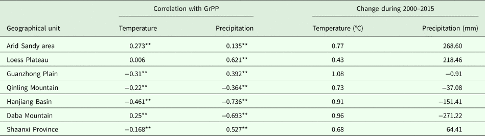
**P < 0.01 (bilateral).
Seen from the multi-year GrPP regional averages, the Guanzhong Plain was the most suitable geographical unit for planting summer maize and winter wheat, followed by the Hanjiang Basin, while the Qinling Mountains and Daba Mountains were the most unsuitable (Fig. 4). It is noteworthy that the Arid Sandy area had the smallest GrPP in 2000 (149.8 kg/ha); however, the GrPP of the Arid Sandy area outstripped that of the Qinling Mountains and Daba Mountains after 2005 (Fig. 5).
Grain production potential change in Arid Sandy area
From 2000 to 2015, there was an increase of 1724.29 kg/ha in modelled GrPP of the Arid Sandy area, which was the geographical unit with the greatest increase in GrPP. In particular, between 2005 and 2010 it increased by 863.72 kg/ha, with an annual growth of 172.74 kg/ha. In 2000, the Arid Sandy area not only had the lowest GrPP, but also accounted for the smallest percentage of total GrPP of Shaanxi Province. However, this percentage increased from 0.7 to 6.7% in 2015, which was greater than that of Qinling Mountain and Daba Mountain. Land use change and climate change were both realized as production increasing effects, but the impact of climate change was much greater than land use change (Table 1). Moreover, although the change in temperature and precipitation were related positively to changes in GrPP, the yield-increasing effect of increasing temperature was more pronounced than that of precipitation in the Arid Sandy area (Table 3). Between 2000 and 2015, the area of cultivated land increased by 22 thousand ha, via conversion mostly from grassland. The conversion from grassland to cultivated land was the main land use change reason for increasing GrPP.
Grain production potential change in Losses Plateau
Similar to the trend of GrPP change in the Arid Sandy area, the modelled GrPP of the Loess Plateau increased from 2000 to 2015, with an increase of 863.24 kg/ha since 2000. The increasing GrPP was caused mainly by precipitation change, and the correlation with temperature change was very small. Overall, climate change improved GrPP by 1086.57 kg/ha in the Loess Plateau. However, land use reduced GrPP by 110.10 kg/ha, which was due mainly to the reduction of cultivated land area. More than 430 thousand ha of cultivated land were converted to other types of land, of which 0.65 and 0.25 were converted to grassland and woodland, respectively. Although the GrPP in Loess Plateau was less than that of the Guanzhong Plain and Hanjiang Basin, the total GrPP in the Loess Plateau accounted for >30% of the total GrPP in Shaanxi Province, greater than that in Hanjiang Basin; it even reached 41.9% in 2015.
Grain production potential change in Guanzhong Plain
Guanzhong Plain was the geographical unit with the greatest GrPP in each year (Figs 4 and 5); it also was the geographical unit with the greatest total GrPP before 2010. The GrPP in this geographical unit presented a trend of initial increase followed by a decrease over the period 2000–2015, reaching an extreme value of 8773.97 kg/ha in 2010. The GrPP increased by 12.68 kg/ha between 2000 and 2015 in Guanzhong Plain, which was the smallest change in GrPP seen in the current study. However, the GrPP in Guanzhong Plain experienced dramatic inter-annual fluctuations; especially during 2000–2005 and 2010–2015, which were greater than in any other geographical units. Guanzhong Plain also was the geographical unit with the smallest change in total GrPP during 2000–2015, only increasing by 0.03 million tons.
Land use change and climate change had the same level of influence on GrPP change in Guanzhong Plain; however, the directions of influence were opposite. Land use change led to a reduction of 352.83 kg/ha in GrPP, which was due mainly to the conversion of cultivated land to construction land. However, GrPP increased by 387.67 kg/ha as a consequence of climate change (Table 1). Changes in temperature and precipitation both affected the change in GrPP. Nevertheless, change in precipitation was more important of these factors (Table 3).
Grain production potential change in Qinling Mountains
In general, the modelled GrPP of the Qinling Mountains declined by 93.36 kg/ha during 2000–2015; however, it first decreased and then increased, reaching a minimum of 474.34 kg/ha in 2010. It should be noted that Qinling Mountains was the geographical unit with the smallest change in GrPP after 2005 (Fig. 4). Moreover, the total GrPP of the Qinling Mountains decreased by 0.49 million tons between 2000 and 2015, which was the greatest reduction among the six geographical units. Dramatically, the total GrPP was greater than that of the Arid Sandy area before 2010; especially in 2000, the former was more than 14 times that of the latter; however, the total GrPP of the Arid Sandy area exceeded that of the Qinling Mountains in 2015. Climate change reduced the GrPP in the Qinling Mountains by 94.5 kg/ha. Change in GrPP in this region was correlated negatively with both changes in temperature and precipitation; the latter had a more pronounced yield-reducing effect (Table 3). However, as some grassland, woodland and other types of land use were reclaimed as farmland, the GrPP increased by 1.62 kg/ha, and to some extent, the negative effects of climate change were offset.
Grain production potential change in Hanjiang Basin
Opposite to the trend of GrPP change in Guanzhong Plain, the GrPP in the Hanjiang Basin firstly declined and then increased, reaching a minimum of 3015.4 kg/ha in 2010 (Fig. 5). However, the GrPP reduced by 217.57 kg/ha in 2015 compared with that in 2000. Thus, Hanjiang Basin area was the geographical unit with the greatest decrease in GrPP between 2000 and 2015. In addition, it was also the geographical unit with the greatest annual decrease in GrPP during 2000–2010. Although the GrPP in Hanjiang Basin was only second to Guanzhong Plain in each year, the total GrPP was less than that in Guanzhong Plain and the Loess Plateau due to its relatively small area.
Interestingly, Hanjiang Basin was the only geographical unit in which the impact of land use change on GrPP change was greater than climate change (Table 1). The results showed that urban land use devouring farmland was the main reason for the reduction of GrPP in Hanjiang Basin. Although the yield-reducing effect of climate change was weaker than land use change, the consequences of climate change are hard to ignore and there was a strong correlation between climate change and the decline in GrPP. Compared with other geographical units, the correlation coefficients between the modelled GrPP in Hanjiang Basin and both precipitation and temperature change were the greatest (Table 3).
Grain production potential change in Daba Mountains
In the Daba Mountains, there was a trend of the first decline and then increase in GrPP, reaching a minimum of 235.05 kg/ha in 2010 (Fig. 5). In total, GrPP declined from 411.65 kg/ha in 2000 to 391.9 kg/ha in 2015, with an annual reduction of 1.32 kg/ha. In 2000, the GrPP was greater than that in the Arid Sandy area, which was the geographical unit with lowest GrPP; however, the geographical unit with lowest GrPP became the Daba Mountains from 2005 onwards. This was caused by the annual GrPP reduction of 21.77 kg/ha during 2000–2005. Furthermore, the total GrPP only declined by 0.04 million tons between 2000 and 2015. Thus, the Daba Mountains was the geographical unit with the smallest reduction in total GrPP. Since 2000, the area of cultivated land in the Daba Mountains changed much less than other geographical units, only reducing by about 0.4 thousand ha. Therefore, the impact of both land use change and climate change on the GrPP of the Daba Mountains was the smallest among all geographical units (Table 1). Climate change resulted in the GrPP declined by 18.58 kg/ha. As the major factor affecting GrPP in Daba Mountains, changes in precipitation presented a negative effect on GrPP, while temperature change had a positive effect that mitigated the negative effect of changes in precipitation. (Table 3).
Discussion
Climate change was the most important reason for GrPP change, either seen from the whole of Shaanxi Province or seen from each geographical unit. In detail, it presented yield-improving effects to the north of the Qinling Mountains and yield-reducing effects to the south of the Qinling Mountains. Interestingly, the effect of climate change on GrPP declined from north to south; although the effect of climate change on the Daba Mountains was the smallest, it was still much greater than the effect of land use change. The Qinling Mountains are the dividing line between the North Temperate Zone and the Sub-tropical Zone in China (Li et al., Reference Li, Lu, Yan, Liu, Kong and Wang2018). It has previously been observed that climate change can increase food production in high latitudes but is not conducive to agricultural production at low latitudes (Tatsumi et al., Reference Tatsumi, Yamashiki, da Silva, Takara, Matsuoka, Takahashi, Maruyama and Kawahara2011).
It was found that GrPP in Shaanxi Province was more sensitive to precipitation changes than temperature, except in the Arid Sandy area in the north of Shaanxi Province. Due to the high latitude, the average temperature in the Arid Sandy area was lower than in all other geographical units. The increased temperature was beneficial to germination and seedling growth, provided more optimal conditions for grain filling and reduced damage by an early frost in the Arid Sandy area (Liu et al., Reference Liu, Yang, Hubbard and Lin2012). For other geographic units, the temperature in 2000 was such that warming reduced GrPP. This is mainly because higher temperatures cause faster crop development and shorter crop duration, and impact the rates of photosynthesis, respiration and grain filling (Kumar et al., Reference Kumar, Aggarwal, Rani, Jain, Saxena and Chauhan2011; Bai et al., Reference Bai, Tao, Xiao, Liu and Zhang2016). In addition, extreme high temperature can greatly damage crop cells and their ability to produce (Ciais et al., Reference Ciais, Reichstein, Viovy, Granier, Ogée, Allard, Aubinet, Buchmann, Bernhofer, Carrara, Chevallier, De Noblet, Friend, Friedlingstein, Grünwald, Heinesch, Keronen, Knohl, Krinner, Loustau, Manca, Matteucci, Miglietta, Ourcival, Papale, Pilegaard, Rambal, Seufert, Soussana, Sanz, Schulze, Vesala and Valentini2005; Lobell and Gourdji, Reference Lobell and Gourdji2012). The effect of temperature change on agricultural production in high latitudes was more pronounced than precipitation. However, change in temperature generally appeared to reduce production and GrPP change was largely at the mercy of changes in precipitation at lower latitudes (Ciais et al., Reference Ciais, Reichstein, Viovy, Granier, Ogée, Allard, Aubinet, Buchmann, Bernhofer, Carrara, Chevallier, De Noblet, Friend, Friedlingstein, Grünwald, Heinesch, Keronen, Knohl, Krinner, Loustau, Manca, Matteucci, Miglietta, Ourcival, Papale, Pilegaard, Rambal, Seufert, Soussana, Sanz, Schulze, Vesala and Valentini2005).
These rainfall variabilities impacted water availability directly and reduced sunshine duration via cloud cover, restricting the efficiency of photosynthesis of crops (Kumar et al., Reference Kumar, Aggarwal, Rani, Jain, Saxena and Chauhan2011; Kassie et al., Reference Kassie, van Ittersum, Hengsdijk, Asseng and Rötter2014). Precipitation was scarce to the north of the Qinling Mountains, and drought was the most important factor restricting agricultural production in these geographical units. Therefore, the increase in precipitation led to an increase in GrPP. Frequent waterlogging seriously threatened stable agricultural production south of the Qinling Mountains due to the annual rainfall being much greater than in the geographical units north of the Qinling Mountains. The reduced precipitation was beneficial to grain production south of the Qinling Mountains.
The current study only analysed the influence of temperature and precipitation on the GrPP. The effect of solar radiation, wind speed, relative humidity, carbon dioxide and other climatic factors were not considered. Moreover, only the correlation between GrPP change and changes in temperature and precipitation were analysed macroscopically, and the specific trends of temperature and precipitation induced change were not clarified. These deficiencies inevitably limited the credibility of the conclusions. In view of this, the current authors plan to address these issues in a subsequent publication.
Although climate change was the main factor affecting GrPP in most geographical units, land use change had a remarkable yield-reducing effect in Loess Plateau, Guanzhong Plain and Hanjiang Basin. The impact of land use change on GrPP was greater than climate change in the Hanjiang Basin, in particular. Guanzhong Plain and Hanjiang Basin were not only the most suitable for crop growth, but also had the fastest rate of urbanization, reflecting the terrain, topography and hydrological conditions (Liu et al., Reference Liu, Xu and Chen2015). Thus, there were about 130 thousand ha of cultivated land converted to built-up land in Guanzhong Plain and Hanjiang Basin, causing the total GrPP to decline by more than 1 mt. Between 2000 and 2015, the modelled GrPP of these two geographical units both reduced, but the process of change had a negative correlation. Change in land use showed a yield-reducing effect in both Guanzhong Plain and Hanjiang Basin, that is, the area of cultivated land was decreasing. Therefore, it can be affirmed that the main cause of the diametrically opposed change in GrPP of these two geographical units was climate change. More specifically, it was caused by changes in precipitation. This was because there was a negative correlation between temperature change and modelled GrPP change within both geographical units, but precipitation change had a different effect on GrPP. Thus, change in precipitation led to the opposite course of GrPP change in Guanzhong Plain and Hanjiang Basin.
In recent decades, the Chinese government has been committed to the control and prevention of soil erosion in the Loess Plateau and adopted a series of effective ecological restoration measures, such as Grain for Green Project and repairing vegetation (Chen et al., Reference Chen, Wang, Wei, Fu and Wu2010; Fu et al., Reference Fu, Liu, Lü, He, Zeng and Wu2011; Feng et al., Reference Feng, Fu, Piao, Wang, Ciais, Zeng, Lü, Zeng, Li, Jiang and Wu2016). Therefore, in the Loess Plateau about 300 thousand ha and 100 thousand ha of cultivated land have been converted to grassland and woodland, respectively, resulting in a decrease in GrPP.
Overall, the area of cultivated land in Shaanxi Province decreased during 2000–2015; the main reasons were the implementation of the Grain for Green Project and the expansion of construction land caused by rapid urbanization, leading to the conversion of cultivated land to grassland (364 thousand ha), construction land (155 thousand ha) and woodland (129 thousand ha). However, the GrPP profited from climate change, especially to the north of the Qinling Mountains. The utilization of land resources and climate resources by agricultural production in Shaanxi Province was not completely rational. For example, in the Loess Plateau and Guanzhong Basin, the improvement of climate resources led to a continuous increase in GrPP; however, significant decreases in the area of cultivated land, coupled with the non-grain use of cultivated land, resulted in poor utilization of climate resources in agricultural production. Even more inefficiently, large-scale grasslands were still cultivated as arable land in the context of deteriorating climatic conditions in the Daba Mountains.
In future, the area of cultivated land in Shaanxi Province will be further reduced due to the rigid demand for construction land and the benefit driven of non-grain use of cultivated land in the process of urbanization (Xie et al., Reference Xie, Zhou, Zhang, Ge, Lang and Zhang2006; Qi et al., Reference Qi, Zhou and Liu2013). In addition, climate conditions will be more beneficial to agricultural production to the north of the Qinling Mountains (Sui et al., Reference Sui, Lang and Jiang2015; Zhang et al., Reference Zhang, Li, Xu and Zhang2017). Therefore, under the restriction that available cultivated land will be more challenging for grain production in the future, increasing capital investment, innovative agricultural technology, reforms to the land system and optimization of land use patterns will be required to fully tap the potential of grain production and promote the conversion rate of GrPP to actual production. Such interventions will be increasingly necessary to guarantee the stable development of regional agriculture and food security.
Conclusion
Changes in modelled GrPP showed significant regional differences under the influence of climate change and land use change. These results showed that GrPP increased to the north but declined to the south of the Qinling Mountains between 2000 and 2015. Specifically, GrPP increased year on year north of the Qinling Mountains but declined first and then increased south of the Qinling Mountains. Climate change was the most important reason for GrPP change in each geographical unit except Hanjiang Basin. In detail, it presented yield-improving effects north of the Qinling Mountains and yield-reducing effects south of the Qinling Mountains. The effects of climate change on GrPP declined from north to south. The impact of precipitation change on GrPP was greater than temperature change in all geographical units except the Arid Sandy area. Although land use change had far less impact on GrPP than climate change in most geographical units, it had a remarkable yield-reducing effect in the Loess Plateau, Guanzhong Plain and Hanjiang Basin. Urban expansion and occupation of farmland, and the return of farmland to forest and grassland were the most obvious land use changes that reduced the GrPP. Under the restriction it will be difficult to increase the area of cultivated land in future, optimize the land use to better match the spatial pattern of cultivated land and agricultural climate resources, and increase capital and technology input to improve the conversion of GrPP to actual production would be the inevitable choices for agricultural development in China.
Financial support
This research was conducted under the auspices of National Natural Science Foundation of China (41701094), Natural Science Basic Research Plan in Shaanxi Province of China (2018JQ4024) and Special Scientific Research Project of Education Department of Shaanxi Province (17JK0761).
Conflict of interest
The authors declare that there are no conflicts of interest regarding the publication of this paper.
Ethical standards
Not applicable.


