


INTRODUCTION
The Sudeten (Sudety) Mountains, or Sudetes, form a northwest (NW) to southeast (SE) trending range with their western end in Germany and separating southwestern Poland from the Czech Republic (Czechia). With the highest peak reaching 1603 m, this represents an uplifted block of rocks metamorphosed during the Variscan orogeny, in the Late Devonian to Early Carboniferous (Don and Zelaźniewicz, Reference Don and Zelaźniewicz1990). The Variscan involved complex faulting and thrusting, forming horsts and graben basins, the latter infilled during later tectonically quiescent geologic episodes, prior to significant reactivation of these structures in the Neogene–Quaternary (Oberc, Reference Oberc1977; Dyjor, Reference Dyjor1986; Mignoń, Reference Migoń1997). The foreland region north of these mountains, into which these structures extend, is drained by the Odra (Oder) and several of its left-bank tributaries, the main river flowing NW and then northwards, forming the western boundary of Poland, towards the Baltic (Fig. 1). An earlier, somewhat different drainage pattern in the Sudeten Foreland is evident from the subsurface preservation of buried valley fragments, recognized from boreholes and quarries and now largely buried by glacigenic and later fluvial sediments (Krzyszkowski et al., Reference Krzyszkowski, Przybylski and Badura1998; Michniewicz, Reference Michniewicz1998; Przybylski et al., Reference Przybylski, Badura, Czerwonka, Krzyszkowski, Krajewska and Kuszell1998). It is apparent, therefore, that this drainage system was disrupted by advances of Scandinavian ice from the north and NW (Krzyszkowski, Reference Krzyszkowski1996; Krzyszkowski and Ibek, 1996; Michniewicz, Reference Michniewicz1998; Salamon, Reference Salamon1998; Salamon et al., Reference Salamon, Krzyszkowski and Kowalska2013; Fig. 1). The drainage has also been disrupted during the Quaternary by slip on the Sudetic Marginal Fault, the effects of which are readily visible in terms of vertical offset in terrace heights either side of the fault line (e.g., Krzyszkowski et al., Reference Krzyszkowski, Migoń and Sroka1995, Reference Krzyszkowski, Przybylski and Badura1998, Reference Krzyszkowski, Przybylski and Badura2000; Krzyszkowski and Bowman, Reference Krzyszkowski and Bowman1997; Krzyszkowski and Biernat, Reference Krzyszkowski and Biernat1998; Krzyszkowski and Stachura, Reference Krzyszkowski and Stachura1998; Migoń et al., Reference Migoń, Krzyszkowski and Gogół1998; Štěpančíková et al., Reference Štěpančíková, Stemberk, Vilímek and Košťák2008; cf. Novakova, Reference Novakova2015). To these glacial and tectonic influences can now be added the effects on Quaternary landscape evolution of a complex history of crustal behaviour, potentially related to the characteristics of the Proterozoic to Palaeozoic crust in the region, as will be discussed subsequently.
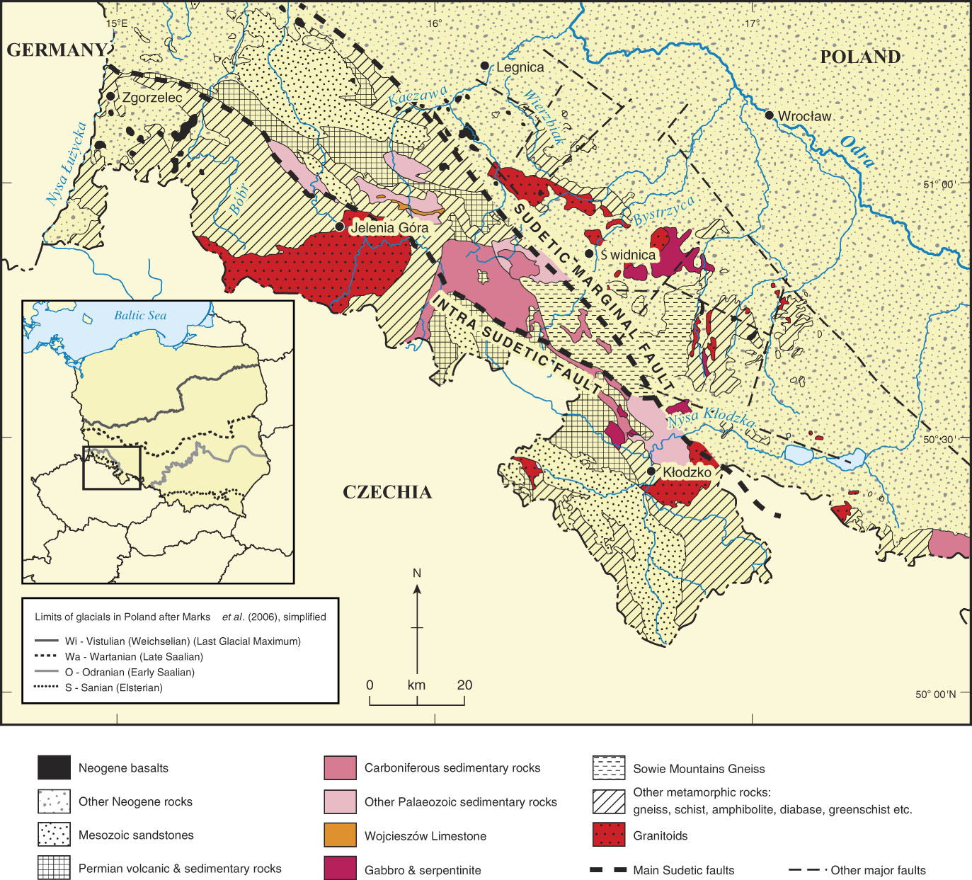
Figure 1. (colour online) Geology and location of the research area. The inset shows the limits of the various Quaternary glaciations of Poland and the course of the River Odra. Modified from Czerwonka and Krzyszkowski (Reference Czerwonka and Krzyszkowski2001).
The repeated glaciation of this region has been well researched and is documented by the glacigenic deposits that form much of the surface cover, burying the evidence for the aforementioned preglacial drainage. The most extensive glaciation was that during the Elsterian, the “Sanian glaciation” of Polish nomenclature (Marks, Reference Marks2011). This glaciation, assumed to have occurred during Marine Oxygen Isotope Stage (MIS) 12 (Krzyszkowski et al., Reference Krzyszkowski, Wachecka-Kotkowska, Wieczorek and Stoiński2015), may not have been the first within the study area, as there are well-developed cold-stage minima within the marine oxygen isotope record in the latest Early Pleistocene, in MIS 22, and the early Middle Pleistocene: especially MIS 16, represented by the Don glaciation in the northern Black Sea region (e.g., Turner, Reference Turner1996; Matoshko et al., Reference Matoshko, Gozhik and Danukalova2004). No pre–MIS 12 glacigenic deposits have been recognized in the Sudetic marginal region, however, and it is clear that any such glaciation was less extensive than that in the Elsterian. The next most extensive glaciation was the Early Saalian (Odranian), with a limit typically 0–18 km short of the Elsterian (Sanian) ice front (Fig. 1, inset); it is generally attributed to MIS 6 (Marks, Reference Marks2011). Then followed the Late Saalian glaciation, termed the Middle Polish Complex or Wartanian, and the Weichselian (last) glaciation, the North Polish Complex or the Vistulian. The highest massifs within the Sudetes supported small-scale local Weichselian glaciers (Migoń, Reference Migoń1999; Traczyk, Reference Traczyk2009), and such glaciers would also have existed during earlier major glaciations, albeit with little effect on foreland drainage evolution.
The study area coincides with the southern edge of the northern European glaciated zone in which fluvial drainage courses have been strongly influenced by repeated glaciation from the north. That zone, from Lithuania through Poland and into Germany, is characterized by broadly east–west aligned valleys that were formed when drainage from the south was deflected westward, towards the Atlantic, by ice sheets blocking the lower courses of the various Baltic rivers: the Urströmtäler of Germany and pradolina of Poland (e.g., Kozarski, Reference Kozarski1988; Marks, Reference Marks2004). Deflection of drainage by the Elsterian and, later, by the Odranian ice is likely to have influenced the modern position of the river valleys in the lowland north of the Sudetic margin (Krzyszkowski, Reference Krzyszkowski2001).
The major existing rivers of the Sudeten Foreland have well-developed terrace systems that record valley incision since the most recent glaciation of the region, which was during the Odranian, given that the later Late Saalian (Wartanian) and Weichselian (last glacial maximum [LGM]) ice sheets failed to reach the mountain front (Fig. 1, inset). Terrace systems are well documented in the two largest Sudetic tributaries of the Odra, the Bystrzyca (Berg, 1909; Krzyszkowski and Biernat, Reference Krzyszkowski and Biernat1998) and the Nysa Kłodzka (Zeuner, Reference Zeuner1928; Krzyszkowski et al., Reference Krzyszkowski, Przybylski and Badura1998), as well as in several of the smaller systems. The Quaternary record in this area was thoroughly reviewed in a 1998 special issue of Geologia Sudetica (Krzyszkowski, 1998) that was dedicated to Frederick E. Zeuner, who conducted his doctoral research in the region (Zeuner, Reference Zeuner1928; see Supplementary Fig. 1), from which he formulated many of his influential views on river-terrace formation (Zeuner, 1945, 1946, 1958, 1959). Since the founding of the Fluvial Archives Group (Briant et al., Reference Briant, Bridgland, Cordier, Rixhon and van Balen2018), debate about the genesis of river terraces has led to a consensus that they are generally a result of uplift, with strong climatic and isostatic influences (e.g., Maddy, Reference Maddy1997; Antoine et al., Reference Antoine, Lautridou and Laurent2000; Bridgland, Reference Bridgland2000), the latter seen to vary in relation to crustal type (Westaway et al., Reference Westaway, Bridgland and Mishra2003, Reference Westaway, Bridgland and White2006, Reference Westaway, Bridgland, Sinha and Demir2009; Bridgland and Westaway, Reference Bridgland and Westaway2008a, Reference Bridgland and Westaway2008b, Reference Bridgland and Westaway2012, Reference Bridgland and Westaway2014; Bridgland et al., Reference Bridgland, Westaway, Abou Romieh, Candy, Daoud, Demir and Galiatsatos2012, Reference Bridgland, Demir, Seyrek, Daoud, Abou Romieh and Westaway2017).
Landscape evolution in the study area has been complex, with combined influences from glaciation, active faulting, and regional crustal processes. The present-day topography is almost entirely the result of postglacial fluvial erosion, in combination with the various processes that modify valley-side slopes and convey sediment into valley bottoms. “Postglacial” in this region means post-Sanian (Elsterian) or post-Odranian (Early Saalian), these being the only Pleistocene glacial periods during which ice sheets are known to have reached the Sudetic Foreland (as noted previously; Fig. 1, inset). The modern valleys have thus formed since these ice sheets encroached on the region, and their flanks preserve latest Middle Pleistocene–Upper Pleistocene river-terrace sequences (Fig. 2). These valleys are incised into a landscape substantially formed in late Middle Pleistocene glacigenic deposits, including diamictons, outwash sands and gravels, and lacustrine sediments (Krzyszkowski, 1998, Reference Krzyszkowski2013). Evidence from boreholes and quarry exposures has shown that this glacigenic sedimentation was overprinted onto a preglacial drainage system, recognizable as a complex pattern of palaeovalleys now entirely buried beneath the modern land surface. Thus, preglacial fluvial sediments, which have been attributed to the Pliocene, Lower Pleistocene, and lower Middle Pleistocene, are generally buried beneath later Pleistocene deposits and occupy a relatively low position with the landscape, especially in the aforementioned basin situations. This is in apparent conflict with the expectations of standard river-terrace stratigraphy, in which progressively older deposits would be anticipated in positions progressively higher above the modern valley floor. This standard terrace stratigraphy has, however, been shown to occur only in association with certain, albeit widespread and common, crustal types, as will be explained in the next section.

Figure 2. (colour online) Cross sections through key fluvial sequences in the study area. (A) The River Nysa Kłodzka in the Bardo area (sites 96 and 97 in Figs. 7 and 8), where the river has cut a gorge through an interbasinal (progressively uplifting) ridge, the inset showing the sequence a few kilometres downstream, in the Janowiec–Ożary area (sites 72 and 71 in Figs. 7 and 8), modified from Krzyszkowski et al. (Reference Krzyszkowski, Przybylski and Badura1998). (B) The sequence in the Kłodzko Basin in the Kłodzko–Leszczyna area (site 68 in Figs. 7 and 8), modified from Krzyszkowski et al. (Reference Krzyszkowski, Przybylski and Badura1998). (C) The River Bystrzyca near Lubachów (modified from Krzyszkowski and Biernat, Reference Krzyszkowski and Biernat1998); for location, see Figure 7.
Relation of fluvial archives to crustal type
Westaway et al. (Reference Westaway, Bridgland and Mishra2003) made the important observation that classic river terrace staircases do not occur in regions of cold, ancient, and densely crystallized crust, particularly the cratons that represent fragments of the earliest continental lithosphere. They attributed this phenomenon to the absence of mobile lower crust in such regions, which they realised was essential to provide a positive-feedback response to erosional isostatic uplift, the same uplift that has caused terrace staircases to form on younger crust, including in areas remote from tectonic influence (see Westaway, Reference Westaway2001, Reference Westaway2002a, Reference Westaway2002b; Westaway et al., Reference Westaway, Maddy and Bridgland2002; Bridgland and Westaway, Reference Bridgland and Westaway2008a, Reference Bridgland and Westaway2008b, Reference Bridgland and Westaway2014). Subsequent reviews of fluvial archives from different crustal provinces showed distribution patterns that can be related to crustal type; in this the northern Black Sea hinterland, ∼1000 km to the east/southeast (ESE) of the present research area, represents a valuable case-study region, where the range of dating proxies is exemplary (Bridgland and Westaway, Reference Bridgland and Westaway2008a, Reference Bridgland and Westaway2008b, Reference Bridgland and Westaway2014; Bridgland et al., Reference Bridgland, Demir, Seyrek, Daoud, Abou Romieh and Westaway2017; cf. Matoshko et al., Reference Matoshko, Gozhik and Danukalova2004; Fig. 3). The significant differences in preservation patterns of fluvial archives between crustal provinces with different characteristics point to important contrasts in landscape evolution, in particular relating to the extent of valley incision (Westaway et al., Reference Westaway, Bridgland and Mishra2003, Reference Westaway, Bridgland, Sinha and Demir2009), as well as the propensity for loss of fluvial archives to erosional processes, which will be greater in areas of dynamic and rapidly uplifting crust. Investigations have led to the concept that these geomorphic effects are controlled by a combination of crustal properties, namely, heat flow (see Fig. 4C) and the depth of the base of the felsic crustal layer; that is because these properties govern the thickness of the plastic crustal layer beneath the brittle upper part of the crust, the base of which corresponds to a temperature of ∼350°C. Thus, if this plastic layer is absent, as in cratonic regions, the crust is extremely stiff and therefore ultrastable. If the mobile layer is thick (thickness >∼6 km), it plays a major role in isostatic adjustment, and continuous uplift occurs, at rates that vary in response to rates of erosional forcing and thus to climate change. On the other hand, if this layer has an intermediate thickness (∼4–6 km), a more complex isostatic response occurs, characterized by alternations of uplift and subsidence, possibly because under such conditions the isostatic responses in the mobile lower crust and in the asthenospheric mantle occur at comparable rates but on different time scales (Westaway and Bridgland, Reference Westaway and Bridgland2014).

Figure 3. (colour online) The Rivers of the northern Black Sea region (modified from Bridgland and Westaway, Reference Bridgland and Westaway2014; after Matoshko et al., 2002; Reference Matoshko, Gozhik and Danukalova2004). (A) The locations of parts B–D in relation to the Ukrainian Shield. (B) Idealized transverse profile through the Middle–Lower Dniester terrace sediments, which represent a classic river terrace staircase (with approximately one terrace per 100 ka climate cycle following the mid-Pleistocene Revolution) inset into Miocene fluvial basin-fill deposits. This region has higher heat flow than might be expected from its location at the edge of the East European Platform (see panel A), for reasons discussed in detail by Westaway and Bridgland (Reference Westaway and Bridgland2014). (C) Transect across the Middle Dnieper basin, ∼100 km downstream of Kiev (∼240 km long), showing a record typical of an area with no considerable net uplift or subsidence during the Late Cenozoic, as typifies cratonic crustal regions (cf. Westaway et al., Reference Westaway, Bridgland and Mishra2003). (D) Transect through the deposits of the Upper Don near Voronezh, showing a combined stacked and terraced sequence that points to fluctuation between episodes of uplift and of subsidence during the past ∼15 Ma.

Figure 4. (colour online) Crustal characteristics. (A) Crustal provinces in the European continent and neighbouring areas. Modified from Pharaoh et al. (Reference Pharaoh, England, Verniers and Zelazniewicz1997); the location of parts B and C is shown. (B) Crustal provinces in Poland. Modified from Mazur et al. (Reference Mazur, Aleksandrowski, Kryza and Oberc-Dziedzic2006). DFZ, Dolsk Fault Zone; OFZ, Odra Fault Zone. (C) Contours of surface heat flow in Poland. Modified from Bujakowski et al. (Reference Bujakowski, Barbacki, Miecznik, Pająk and Skrzypczak2016), using data from Szewczyk and Gientka (Reference Szewczyk and Gientka2009). Plus and minus signs are used to aid interpretation in greyscale.
Different patterns of fluvial sediment preservation are indeed evident in Poland and can be interpreted according to the different crustal regions within which they occur (see Fig. 4). The occurrence of buried Pliocene and Lower Pleistocene fluvial deposits, as reported in the present study region, has also been observed in the middle reaches of the Vistula river system (Mojski, Reference Mojski1982; Bridgland and Westaway, Reference Bridgland and Westaway2014; Fig. 5), the catchment of which accounts for 56% of Poland. The Middle Vistula flows across the East European Platform (EEP), a crustal province consolidated during the Early or Middle Proterozoic that is relatively stable in comparison with the younger crust to the west, including that beneath the Sudeten Mountains, which are part of the Variscan province, stretching from southwestern Poland to western Europe (southern England–Iberia; Fig 4). Farther SE within the EEP, patterns of fluvial-archive preservation in which older deposits are buried by younger terraced sequences have again been observed—for example, in the valley of the River Don, one of the northern Black Sea rivers, near Voronezh (Matoshko et al., Reference Matoshko, Gozhik and Danukalova2004; Bridgland and Westaway, Reference Bridgland and Westaway2008a, Reference Bridgland and Westaway2008b, Reference Bridgland and Westaway2014; Fig. 3). The alternation between uplift and subsidence implicit in these preservation patterns has been ascribed to the properties of the crust of the EEP; such crust is highly consolidated and relatively cold, with a lower mobile layer of limited thickness (probably a few kilometres at most), making it very much less dynamic than younger crustal types (Westaway and Bridgland, Reference Westaway and Bridgland2014; Bridgland et al., 2017; cf. Kutas et al., Reference Kutas, Lubimova and Smirnov1979).

Figure 5. (colour online) Comparison of fluvial archives in different parts of the River Vistula system. (A) Location. (B) Transect through the valley of the River Dunajec, central Carpathians (modified from Zuchiewicz, Reference Zuchiewicz1992, Reference Zuchiewicz1998). (C) Transect through the valley of the River San (after Starkel, Reference Starkel2003). MIS, Marine Oxygen Isotope Stage. (D) Idealized transverse sequence through the deposits of the Middle Vistula, based on data from upstream (Mojski, Reference Mojski1982) and downstream (Zarski, Reference Zarski1996; Marks, Reference Marks2004) of Warsaw.
Farther north, the Lower Vistula, in its course towards the Baltic, flows across a region that would appear to have experienced continuous subsidence during the late Middle and Late Pleistocene, as indicated by the stacking of younger Pleistocene deposits, including fluvial, glacial, and even marine sediments, above older (cf. Marks, Reference Marks2004). This could reflect the wider influence of isostatically induced subsidence of the long-standing depocentre of the Baltic basin, where the crust has been progressively depressed beneath the sedimentary load. In marked contrast, there are areas in the extreme SE of Poland, in the uppermost Vistula catchment, which display the only extensive staircases of river terraces in the country, similar to those on the younger, more dynamic crust of northwestern Europe. These terrace staircases (Fig. 5) can be found in the catchments of the Rivers Dunajec (Zuchiewicz, Reference Zuchiewicz1992; Olszak, Reference Olszak2011) and San (Starkel, Reference Starkel2003), as well as in other tributaries of the Vistula that drain the continental crust forming the Western Carpathian Mountains (e.g., Zuchiewicz, 2011; Pliszczyńska, Reference Pliszczyńska2012). These archives generally occur on crust bordering the Western Carpathians that was affected by the Caledonian orogeny and is thus more dynamic than that of the EEP. (For a description of the Late Cenozoic palaeogeographic evolution of this area, see Brud [2004].) As Bridgland and Westaway (Reference Bridgland and Westaway2014) noted, the headwaters of the San are close to those of the Dniester, a river flowing southwards to the Black Sea that has an impressive and well-dated terrace staircase (Matoshko et al., Reference Matoshko, Gozhik and Danukalova2004; Fig. 3B). Thus, despite their flowing in opposite directions, the San and the Dniester have similar styles of fluvial archive preservation, attributable to the nature of the crust in that region rather than hydrologic or base-level influences (cf. Bridgland and Westaway, Reference Bridgland and Westaway2014). Elsewhere in Poland, there is localized downwarping as a result of salt diapirism, particularly at Bełchatów, near Łódź (Krzyszkowski, Reference Krzyszkowski1995; Krzyszkowski and Szuchnik, Reference Krzyszkowski and Szuchnik1995; Wieczorek et al., Reference Wieczorek, Stoiński, Krzyszkowski, Wachecka-Kotkowska and Krzymińska2015).
Bridgland and Westaway (Reference Bridgland and Westaway2014) suggested that, although the prevalence of stacked sequences in northern Poland might reflect proximity to the Baltic basin, aspects of the fluvial archive preservation pattern in central Poland that have traditionally been attributed to the effects of glaciation, or glaciation interspersed with marine transgression (e.g., Marks, Reference Marks2004), might instead result from the characteristics of the crust. They envisaged three provinces within the Vistula: (1) an upstream, uplifting province, with well-developed terraces; (2) a central province in which the comparative stability of the EEP is dominant; and (3) a downstream (northern) province with increasing influence of subsidence around the Baltic Basin and the effects of repeated glaciation.
The fluvial sedimentary archives in parts of the Sudetic Foreland suggest inversion in vertical crustal movement, with alternation of subsidence and uplift, as surmised previously in systems such as the Don (Westaway and Bridgland, Reference Westaway and Bridgland2014; Bridgland et al., Reference Bridgland, Demir, Seyrek, Daoud, Abou Romieh and Westaway2017; Fig. 3D). In previous reviews of the preservation patterns shown by fluvial archives, in which causal linkages have been observed with crustal type, such archives indicative of alternating subsidence and uplift were found to be associated commonly with Early or Middle Proterozoic crustal provinces with thick “roots” of mafic material at the base of the crust, restricting the thickness of the mobile lower crustal layer (Westaway and Bridgland, Reference Westaway and Bridgland2014; Bridgland et al., Reference Bridgland, Demir, Seyrek, Daoud, Abou Romieh and Westaway2017). In the Sudetes, this phenomenon is apparent in the aforementioned basinal areas, which are separated by structural ridges (horsts) of older, generally crystalline rocks (Dyjor, Reference Dyjor1986).
EVIDENCE FOR PREGLACIAL RIVER SYSTEMS IN THE SUDETEN FORELAND
Quarrying and boreholes have allowed the reconstruction of considerable detail with regard to river systems that existed in the Sudetic Foreland in preglacial times (i.e., prior to the Elsterian ice advance, which is the meaning of preglacial in this region). It should be noted, however, that this reconstruction is based on small “windows” of subsurface evidence, providing limited scope for detailed reconstruction of areal three-dimensional form. Beneath the Sanian and Odranian glacial deposits, fluvial sediments of several different types have been recorded, much work having been done in order to characterize and distinguish these, in particular clast-lithologic analysis of their gravel components and heavy mineral analysis of sand grains (Czerwonka et al., Reference Czerwonka, Gratzke and Krzyszkowski1994; Krzyszkowski and Bowman, Reference Krzyszkowski and Bowman1997; Krzyszkowski et al., Reference Krzyszkowski, Przybylski and Badura1998; Przybylski et al. Reference Przybylski, Badura, Czerwonka, Krzyszkowski, Krajewska and Kuszell1998; Krzyszkowski, Reference Krzyszkowski2001, Reference Krzyszkowski2013; Krzyszkowski and Karanter, Reference Krzyszkowski and Karanter2001). Many of these early fluvial deposits are kaolinitic, from the weathering of gneiss, gabbro, serpentinite, schist, and other feldspathic rocks, which, in company with a dominance of rudaceous quartz, gave rise to the term “white gravels”; they have also been referred to as the “preglacial series” (Dyjor, Reference Dyjor1983, Reference Dyjor1986, Reference Dyjor1987a, Reference Dyjor1987b, Reference Dyjor1993; Jahn et al. Reference Jahn, Łańcucka-Środoniowa and Sadowska1984; Dyjor et al., Reference Dyjor, Kvacek, Łańcucka-Środoniowa, Sadowska and Zastawniak1992). The matching of these components to source areas is illustrated in Figure 6. They lie above the Upper Miocene–Lower Pliocene Poznań (Clay) Formation, sometimes with channel or palaeovalley geometries apparent from the subsurface data (Ciuk and Piwocki, Reference Ciuk and Piwocki1979; Ciuk and Pożaryska, Reference Ciuk and Pożaryska1982; Peryt and Piwocki, Reference Peryt and Piwocki2004). Indeed, there is some evidence of incision and even terrace formation within the preglacial sequence (see Supplementary Figs. 2 and 3), much of which is, however, a continuation of the stacked basin fill represented by the Neogene Poznań Formation. The preglacial fluvial deposits can be collectively described under the name Ziębice Group, this being the amalgam of several formations, representing different preglacial river systems, defined by their heavy-mineral content and nonquartz gravel-clast petrography (Czerwonka and Krzyszkowski, Reference Czerwonka and Krzyszkowski2001; Table 1, Figs. 7 and 8). The Ziębice locality in central Poland, formerly called Münsterberg, was where fluvial “white gravel” sediments, lacking Scandinavian material, were first described (Jentzsch and Berg, Reference Jentzsch and Berg1913; Frech, Reference Frech1915; Lewiński, Reference Lewiński1928, Reference Lewiński1929; Zeuner, Reference Zeuner1928; Krzyszkowski et al., Reference Krzyszkowski, Przybylski and Badura1998; Przybylski et al., Reference Przybylski, Badura, Czerwonka, Krzyszkowski, Krajewska and Kuszell1998; Czerwonka and Krzyszkowski, Reference Czerwonka and Krzyszkowski2001; Supplementary Fig. 1).

Figure 6. (colour online) Distribution of provenance indicator materials. Modified from Czerwonka and Krzyszkowski (Reference Czerwonka and Krzyszkowski2001).
Table 1. Characteristic clast data (gravel petrography and heavy mineralogy) used in differentiation of Ziębice Group formations.

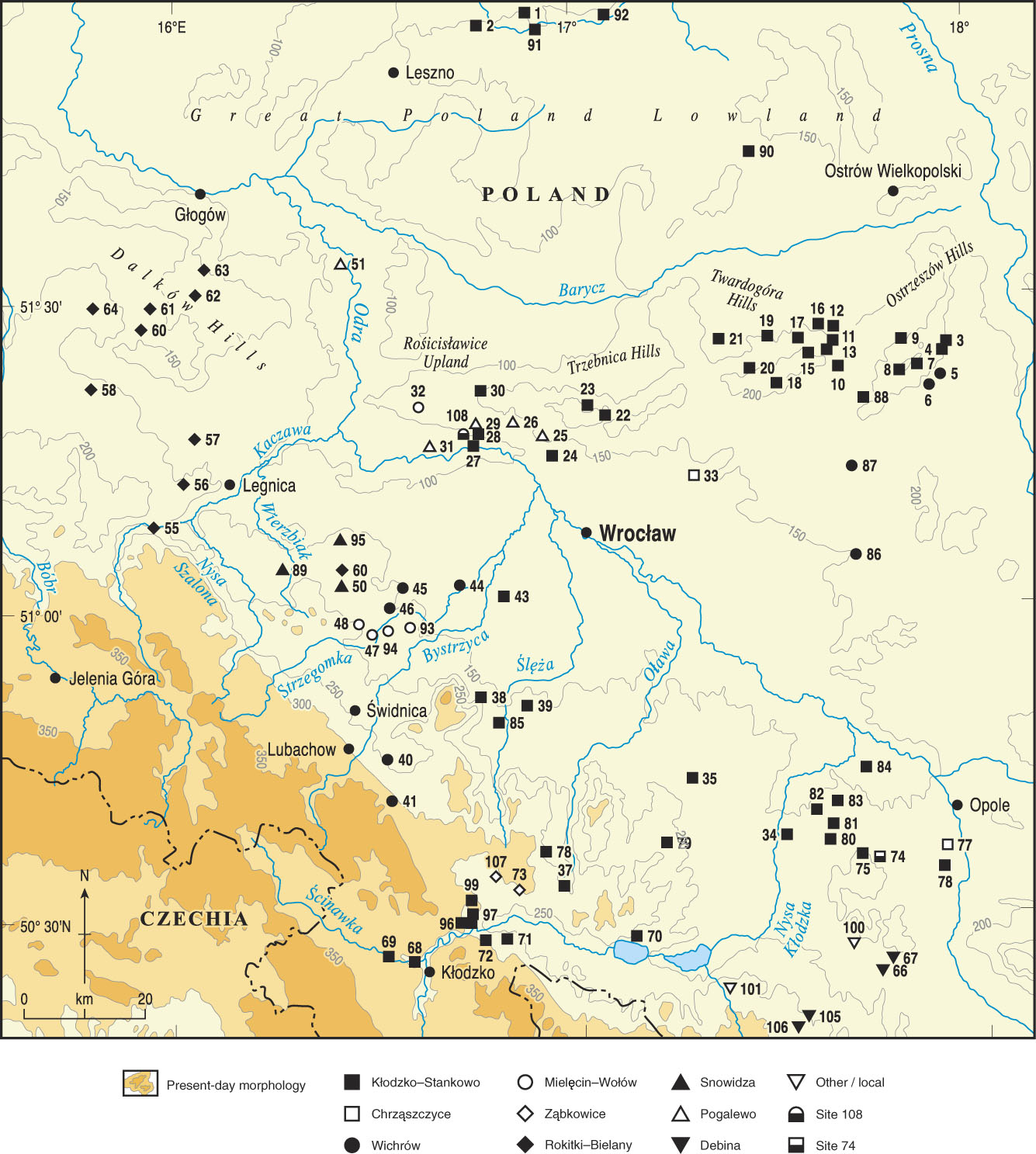
Figure 7. (colour online) Location of preglacial sites (identified by number, with different symbols for the various formations, which represent different river systems). For locality names, see Figure 8. Modified from Czerwonka and Krzyszkowski (Reference Czerwonka and Krzyszkowski2001).

Figure 8. Occurrence of the different preglacial fluvial formations and their constituent members, showing which are present at the various localities. Numbers and symbols correspond with those in Figures 7 and 9–12. Modified from Czerwonka and Krzyszkowski (Reference Czerwonka and Krzyszkowski2001).
Emplacement of the Ziębice Group as a whole can probably be attributed in part to increased mountain uplift and active faulting in the Sudetes and their foreland, perhaps resulting from the global climatic cooling that characterized the mid-Pliocene (e.g., Westaway et al., Reference Westaway, Bridgland, Sinha and Demir2009); downthrown fault basins would have guided the main drainage lines. Each component formation represents sequences deposited by a specific fluvial system originating in the Sudeten Mountains. Within the group as a whole, four informal members (I–IV) have been recognized (Czerwonka and Krzyszkowski, Reference Czerwonka and Krzyszkowski2001), their distinction being broadly age dependent, which is why they have not been formally defined, although there are no means for precise dating. These members are variously represented within the different formations, only two of which have all four members (Table 1, Fig. 9), with each numbered member believed to have been formed approximately synchronously in the different rivers across the region. The supposed ages of the members are relative and rely on superposition (see Supplementary Materials) and sporadic but rare preservation of biostratigraphic evidence (Czerwonka and Krzyszkowski, Reference Czerwonka and Krzyszkowski2001). Supplementary evidence for distinguishing between the members comes from erosional hiatuses at the bases of Members I, III, and IV and from the distinct widening of the valley systems between Members I and III (Czerwonka and Krzyszkowski, Reference Czerwonka and Krzyszkowski2001; compare Figs. 9 and 10). The sedimentology and range and type of facies suggest a meandering fluvial regime for Members I–III, especially away from the mountain front, and a braided river environment for Member IV (Czerwonka and Krzyszkowski, Reference Czerwonka and Krzyszkowski2001). Systematic analyses have been undertaken from exposures and boreholes, including sand heavy mineralogy and gravel-clast lithology, arguably the most valuable, combined with particle-size analysis, quartz (sand) grain angularity–roundness analysis, and palaeocurrent measurements (Czerwonka et al., Reference Czerwonka, Gratzke and Krzyszkowski1994; Krzyszkowski and Bowman, Reference Krzyszkowski and Bowman1997; Krzyszkowski et al., Reference Krzyszkowski, Przybylski and Badura1998; Przybylski et al., Reference Przybylski, Badura, Czerwonka, Krzyszkowski, Krajewska and Kuszell1998; Krzyszkowski, Reference Krzyszkowski2001; Krzyszkowski and Karanter, Reference Krzyszkowski and Karanter2001; Table 1; see Supplementary Materials).

Figure 9. (colour online) Palaeodrainage during emplacement of Member I deposits. Numbers and symbols correspond with those in Figures 7 and 8. Modified from Czerwonka and Krzyszkowski (Reference Czerwonka and Krzyszkowski2001).
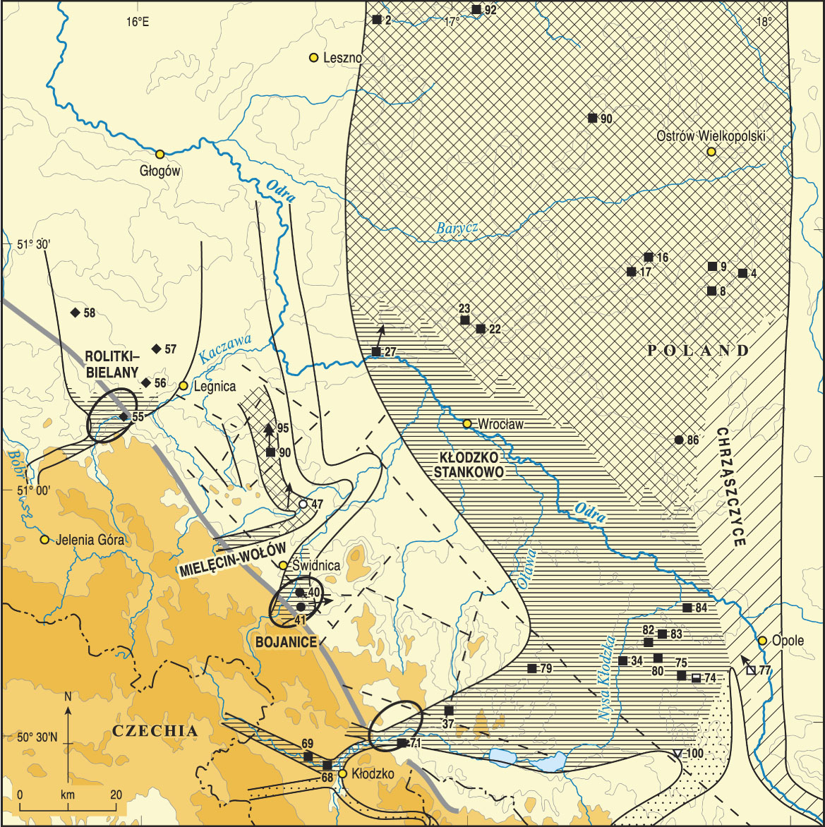
Figure 10. (colour online) Palaeodrainage during emplacement of Member II deposits. Numbers and symbols correspond with those in Figures 7 and 8. Modified from Czerwonka and Krzyszkowski (Reference Czerwonka and Krzyszkowski2001). For key, see Figure 9.
As summarized in Table 1, six main preglacial river systems have been recognized, each with characteristic heavy-mineral signatures and some with distinctive clast-lithologic assemblages. These are (1) the Palaeo-Odra, characterized by a zircon-rutile heavy-mineral assemblage and gravel clasts of Carpathian origin, represented by the Chrząszczyce Formation; (2) the Palaeo-Biała Głuchołaska (staurolite-amphibole mineralogy), represented by the Dębina Formation; (3) the Palaeo-Nysa Kłodzka (staurolite-garnet/amphibole-garnet), represented by the Kłodzko–Stankowo Formation; (4) the Palaeo-Bystrzyca (zircon, sillimanite, and various), represented by the Bojanice Formation (as well, potentially, as the Pogalewo and Wichrów Formations); (5) the Palaeo-Strzegomka (sillimanite-garnet), represented by the Mielęcin–Wołów Formation; and (6) the Palaeo–upper Bóbr/Kaczawa (andalusite), represented by the Rokitki–Bielany Formation. Of these, the Palaeo–Nysa Kłodzka appears to have been the trunk river throughout the “preglacial” period (see Figs. 9–12). Evidence for four additional systems has been recognized but is more localized; these are the Palaeo-Wierzbiak, represented by the Snowidza Formation, the Palaeo-Budzówka, represented by the Ząbkowice Formation, and two other local rivers, near Bardo/Potworów and Szydłów, identified only by gravel-clast analysis (Przybylski et al., Reference Przybylski, Badura, Czerwonka, Krzyszkowski, Krajewska and Kuszell1998) and impossible to match with existing rivers.


These drainage systems probably originated during the Early Miocene, because the Miocene–Lower Pliocene Poznań Formation is thought to represent the low-energy sediments of anastomosing river or inland-delta environments (Peryt and Piwocki, Reference Peryt and Piwocki2004), which, from the available evidence, persisted with relatively little change until disrupted by glaciation in the Middle Pleistocene. It should be noted that those formations with “double-barrelled” names (Kłodzko–Stankowo, Mielęcin–Wołów, and Rokitki–Bielany) are traced for significant distances from the mountain front and have “proximal” type localities (giving the first part of the name) near the Sudetes and “distal” type localities farther downstream. The lack of Scandinavian clasts in these various preglacial fluviatile sediments distinguishes them from the glacial deposits (Elsterian and Lower Saalian) and from the terrace deposits of the postglacial rivers, in which reworked glacially derived material occurs (Schwarzbach, Reference Schwarzbach1955; Jahn, Reference Jahn1960, Reference Jahn1980; Czerwonka and Krzyszkowski, Reference Czerwonka and Krzyszkowski1992; Krzyszkowski Reference Krzyszkowski1995, Reference Krzyszkowski2013; Czerwonka et al., Reference Czerwonka, Dobosz and Krzyszkowski1997).
Turning to the informal members, I–III have generally been attributed to the Pliocene–lowermost Pleistocene, and IV has been attributed to the lower Middle Pleistocene (Cromerian Complex). This seemingly points to a hiatus spanning much of the first half of the Pleistocene, although there may well be unrecognized representation of this interval among sequences that are notoriously difficult to date and that include components that have yet to be defined and characterized fully. Alluvial-fan sediments occur within all members at localities near the mountain front. The Pliocene members can be presumed to represent rivers draining northwards to join the erstwhile Baltic River, which existed as a major east–west flowing system at that time (e.g., Gibbard, Reference Gibbard1988). The drainage represented by Members I–III was sinuous, as indicated by sediment geometry (Figs. 9–11) as well as sedimentology, in contrast to the braided-river deposits of Member IV. This perhaps indicates sedimentation of Members I–III during periods of temperate and relatively moist climate, whereas Member IV records more variable conditions, with evidence of both temperate (interglacial) and cold (periglacial) climates. This contrast could, indeed, be a reflection of climatic cooling in the Early Pleistocene, a trend that would culminate in the glaciations of the Baltic region in the Middle Pleistocene.
The evidence for different preglacial rivers, precursors of the modern drainage of the Polish Sudetic margin, will be described in east-to-west sequence, starting with the Palaeo-Odra, the postglacial successor of which forms the principal arm of the modern regional drainage.
The Palaeo-Odra (Chrząszczyce Formation)
Within the research area, the Chrząszczyce Formation, which is thought to represent the main Palaeo-Odra River, is restricted to locations >20 km from the Sudetic mountain front, entering the region from the SE in the area south of Opole (Figs. 7 and 9–11). It has been studied at relatively few localities at and to the west of Opole and west of Wrocław, with representation only of Members I–III (Table 1, Figs. 9–11). Only at Chrząszczyce, the type locality ∼5 km south/southwest (SSW) of Opole (Figs. 7 and 8; Supplementary Fig. 4), have all three of these members been observed. Gravel analysis has only been possible from the Member III sediments at Ose (Figs. 7 and 8), where the occurrence of Carpathian siliceous rocks (silicified limestones and sandstones, radiolarites, etc.) among a quartz-dominated assemblage provides important support for origin within the Odra catchment (Czerwonka and Krzyszkowski, Reference Czerwonka and Krzyszkowski1992). There are subtle changes in heavy mineralogy between members (I–III) (Table 1): all have assemblages dominated by zircon, with staurolite and tourmaline, plus garnet in Members I and III and rutile in II and III. Member III at Tulowice has yielded plant macrofossils (leaves and fruit) with close affinity to those of the underlying uppermost Poznań Formation: that is, not older than Late Pliocene (Przybylski et al., Reference Przybylski, Badura, Czerwonka, Krzyszkowski, Krajewska and Kuszell1998).
The Palaeo–Biała Głuchołaska (Dębina Formation)
This is a relatively minor formation, representative of a subordinate river, the most southeasterly that drained the Sudetes Mountains within the study area. Only Member I has been recognized, made up of quartzose gravels with a staurolite-amphibole heavy-mineral suite (Table 1). It has been recognized at a small number of sites from Strybowice to the type locality at Dębina, ∼30 km SSW of Opole (Fig. 7). Although its occurrences trace a course from SSW to north/northeast (NNE), the petrography of the Ziębice Group as a whole, plus knowledge of the bedrock surface, suggests that the palaeoriver turned sharply to the NW in the vicinity of Dębina to a confluence with the Palaeo–Nysa Kłodzka, rather than continuing NNE to join the Palaeo-Odra (Fig. 9). It uncertain whether any of the Dębina Formation sequences continue upwards into Member II, but the existence of a Palaeo–Biała Głuchołaska flowing northeast (NE) from the Sudetes has been reconstructed for that time span, joining a considerably wider Palaeo–Nysa Kłodzka (Fig. 10) in comparison with that reconstructed for Member I. The continued existence of such a river during later times can only be speculative (Krzyszkowski et al., Reference Krzyszkowski, Przybylski and Badura1998).
The Palaeo–Nysa Kłodzka (Kłodzko–Stankowo Formation)
This formation accounts for the vast majority of the preglacial series, being represented at sites over an area of considerable width from its proximal type locality at Kłodzko, in the south (in the Kłodzko [intermontane] basin) eastwards towards (but not reaching) Opole and then northwards to Wrocław and beyond (Fig. 7). This distribution demonstrates the dominance of the Palaeo–Nysa Kłodzka during preglacial times (Figs. 9–12). Its distal type locality, at Stankowo (Fig. 7, site [1]), is at the northern periphery of the study area, ∼20 km NE of Leszno (Fig. 1; Supplementary Fig. 5). The recognition of this formation is based on a gravel-clast lithology reflecting the characteristic geology of the Kłodzko Basin, including gneisses and other crystalline rocks, notably porphyries, together with Mesozoic sandstones and “flint” (Table 1; Figs. 6 and 7). The heavy mineralogy is complex and regionally variable, also changing from staurolite-garnet dominance in Members I–III to garnet and amphibole in Member IV (Table 1).
With the formation represented at >50 sites (Figs. 7 and 8), the comparative distribution of the different members reveals significant changes in the course of this trunk river, with Member I tracing a relatively confined west/southwest (WSW)–east/northeast reach from Kłodzko to Gnojna (Fig. 7 [35]), diverging northwards from the modern Nysa Kłodzka course, and then a wider but still confined reach (in comparison with younger members) from here to Wrocław and Taborek (Fig. 7 [3]), by which point the Palaeo-Odra was converging from the east (Fig. 9). At the time of Member II emplacement, both reaches were considerably wider, that east of Kłodzko spreading southwards to envelop the course of the modern river, whereas in its northward-flowing reach it extended eastwards to meet the Palaeo-Odra ∼10 km west of Opole and spread out northeastwards across the foreland to encompass an area from that of its earlier course to that around Ostrów Wielkolpolski and beyond (Fig. 10).
By Member III times, the palaeoriver had been diverted from near Ziębice into a more confined northerly course towards Wrocław, sweeping across the area south and east of this city towards Ostrów Wielkolpolski, turning northwards as it met the Palaeo-Odra, by this time of almost equal size, and other drainage from the east, possibly the “Bełchatów River,” as recognized in central Poland at the large lignite quarry at Bełchatów (Krzyszkowski, Reference Krzyszkowski1995; Krzyszkowski et al., Reference Krzyszkowski, Wachecka-Kotkowska, Wieczorek and Stoiński2015; Fig. 11).
By Member IV times, there is little evidence that the Palaeo–Nysa Kłodzka extended northeastwards of the modern Odra course, except in the area NW of Wrocław. This suggests that a Palaeo-Odra closely following its modern valley had come into existence by this time, perhaps as a result of early Middle Pleistocene glaciation (Zeuner, Reference Zeuner1928; Fig. 12), otherwise poorly documented because its extent was less than the ice sheets of the Elsterian, the suggestion being that the line of the Odra across the northern edge of the Sudetic Foreland might be of early ice-marginal (“pradolina”) origin.
The Palaeo-Budzówka (Ząbkowice Formation)
The Budzówka is a minor left-bank tributary of the Nysa Kłodzka, joining the latter ∼20 km downstream of Kłodzko. Its preglacial forebear is represented by probable Member IV deposits that occur at two sites, the Ząbkowice type locality [73] and Albertów [107] (Figs. 7, 8, and 12). These deposits are characterized by gravel in which the dominant clast type is Sowie Góry gneiss, with subordinate quartz and other siliceous rocks; there is a garnet-amphibole heavy-mineral suite (Table 1).
The Palaeo-Bystrzyca (Bojanice, Wichrów, and Pogalewo Formations)
The River Bystrzyca, which is the next important Odra tributary moving to the NW along the Sudetes margin, flows through the town of Świdnica on its southwest (SW)–NE course towards a confluence with the trunk river ∼7 km NW of Wrocław; ∼15 km upstream of that confluence it receives a substantial left-bank tributary, the Strzegomka (Fig. 7). Preglacial versions of both these rivers are represented among the Ziębice Group sediments, although with courses that appear to have been entirely separate until the trunk river was reached; at that time, the latter was the Palaeo–Nysa Kłodzka (Figs. 9–12).
Three different preglacial formations are potential products of deposition by the Palaeo-Bystrzyca. First is the Bojanice Formation, of which Members II, III, and possibly IV occur in the vicinity of Świdnica, in the form of porphyry-rich quartz gravels, also containing melaphyre, Sowie Góry gneiss, and quartzite, although the uppermost (potentially Member IV) deposits lack rudaceous components (Table 1). The heavy minerology of these upper deposits is dominated by sillimanite, whereas that of the gravelly facies is dominated by zircon and garnet (Table 1).
The Wichrów Formation is represented by a small group of sites, of which the Wichrów type locality is one, ∼20–30 km NNE of Świdnica, in the modern catchment of the Strzegomka tributary (Figs. 7 and 8 [45]). Only the basal part of the sequence is present, with Member I and a possible extension into Member II, sharing the zircon-rich mineralogy of the lower members within the Bojanice Formation (Table 1). Despite its modern location within the tributary catchment, the Wichrów Formation sites seem likely to represent a downstream continuation of the Palaeo-Bystrzyca from the Świdnica area (Fig. 9).
The Pogalewo Formation is identified in the area much farther from the mountain front, to the north of the modern River Odra downstream of Wrocław. Members I, II, and III are all recognized, albeit at different sites (Figs. 7 and 8). Member I is identified only at the Pogalewo type locality [31], on the northern side of the Odra valley ∼30 km downstream of Wrocław (Fig. 9; Supplementary Fig. 3). It is the only member of this formation to have yielded rudaceous material, this being quartz gravel with local flint and a trace of porphyry; it has a zircon-tourmaline-rutile heavy mineralogy (Table 1). Farther upstream (both within the modern Odra system and the preglacial palaeovalley), ∼5–10 km east of Pogalewo, is a small cluster of sites that represent Member III, which have the same dominant mineralogy but with additional epidote, kyanite, amphibole, and staurolite (Table 1). The intervening Member II, although perhaps represented by the uppermost deposits at Pogalewo, is optimally recorded much farther downstream, at Chałupki [51], ∼30 km SW of Głogów (Fig. 7). The mineralogy of this member is different again, with kyanite in addition to the zircon-tourmaline-rutile suite but lacking epidote, amphibole, and staurolite (Table 1). Although given a separate name, the deposits of the Pogalewo Formation are most readily interpreted as more distal (downstream) Palaeo-Bystrzyca sediments, implying a separate northward course far from the mountain front, especially during emplacement of Member II (Fig. 10).
The Palaeo-Strzegomka (Mielęcin–Wołów Formation)
As noted previously, the modern River Strzegomka joins the Bystrzyca ∼15 km upstream of the confluence between the combined river and the Odra. Prior to the Middle Pleistocene, however, it seems likely that the precursors of these rivers maintained separate courses to the trunk Palaeo–Nysa Kłodzka (Figs. 9–11). The Palaeo-Strzegomka is represented by the Mielęcin–Wołów Formation, as is apparent from the preservation of that formation at sites close to the mountain front within the modern Strzegomka catchment, including the Mielęcin (proximal) type locality (Fig. 7 [47]; Supplementary Fig. 6). The deposits here comprise quartzose/porphyry-rich gravels representing Members I–III, also containing local siliceous rocks (flint); conglomerate, spilite, diabase, greenschist, and quartzite from the Wałbrzych Upland; Strzegom granite and local schist (phyllite); and a sillimanite-garnet heavy-mineral suite (Table 1; Fig. 6). The distal type locality, at Wołów, where only Member I is represented, is located north of the modern Odra, approximately equidistant between Wrocław and Głogów (Fig. 8 [32]). Member IV of the Mielęcin–Wołów Formation is recognized at two sites, Sośnica [43], in the modern Bystrzyca valley upstream of its confluence with the Strzegomka, and Brzeg Dolny 3 [108], north of the modern Odra, where it overlies Member I of the Kłodzko–Stankowo Formation (Figs. 8 and 12; Supplementary Fig. 2). This upper member lacks gravel but is characterized by a sillimanite-dominated heavy mineralogy (Table 1).
The Palaeo–upper Bóbr/Kaczawa (Rokitki–Bielany Formation)
The next Odra tributary northwestwards along the mountain front is the River Kaczawa, which has a confluence with the trunk river ∼20 km downstream from Legnica. Its preglacial forebear, however, had a catchment that penetrated deeper into the mountain zone, including areas now drained by the headwaters of the Bóbr, a yet more westerly Odra tributary that flows NW from the Sudetes to join the trunk river well to the west of the study area (Fig. 7). This is indicated by the characteristic clast lithology of the Rokitki–Bielany Formation, which has rudaceous sediments representing all four members with contents that show drainage from the Bóbr catchment: these are quartzose gravels with porphyry, Karkonosze granite, crystalline rocks, schist, quartzite, with the addition, in Member IV, of Cretaceous sandstone and Wojcieszów limestone (Table 1). The heavy mineralogy is characterized by andalusite and tourmaline, with the addition of epidote in Member I and of kyanite, zircon, garnet, amphibole, and sillimanite in Member IV (Table 1). The proximal type locality of this formation, Rokitki [55], is situated in the Kaczawa valley, ∼ 8 km upstream of its confluence with the Nysa Szalona, a right-bank tributary (Fig. 7). Members I–III are attributed to a Palaeo-Bóbr/Kaczawa that drained northwards, to the west of Legnica, towards Głogów (Figs. 9–11). Member IV of this formation is recognized only at sites in the interfluve area between the Strzegomka and the Kaczawa, at Kępy [95] and Bielany [50] (Fig. 12; Supplementary Fig. 7), where it overlies older members of the Mielęcin–Wołów Formation that represent the earlier northward drainage of the Palaeo-Strzegomka (see the foregoing section; Figs. 1 and 9). Bielany is the distal type locality of the Rokitki–Bielany Formation, although it lies farther south than Rokikti (Fig. 7 [50]). The most northerly Mielęcin–Wołów site is Polkowice [62], <20 km south of Głogów, where only Member III occurs (Figs. 7, 8, and 11).
Other minor rivers
Preglacial tracts of more localized rivers have been traced. The Snowidza Formation, known from a single locality (Fig. 8), represents a possible ancestral River Wierzbiak, the modern river of the same name being a right-bank Kaczawa tributary that joins the latter ∼10 km downstream of Legnica (Fig. 7). The sole representation of the Snowidza Formation is probably equivalent to Member I of other Ziębice Group formations (Fig. 8). The deposits of two other local rivers have been recognized (Fig. 7) in the vicinity of Bardo [96–97], Potworów [98–99], and Szydłów [101] on the basis of gravel-clast petrography (Przybylski et al., Reference Przybylski, Badura, Czerwonka, Krzyszkowski, Krajewska and Kuszell1998). These occurrences are again of probable Member I affinity (Fig. 8).
DATING THE ZIĘBICE GROUP
Much of the dating of the individual components of the Ziębice Group is dependent on their relative stratigraphic positions within the sequence and their relation to the underlying Poznań Formation and overlying Middle Pleistocene glacial deposits. At Gnojna (∼55 km NE of Kłodzko; Fig. 7 [35]), palynological analyses of the uppermost member of the Poznań Formation, immediately below Member I of the Kłodzko–Stankowo Formation, have yielded a flora indicative of the earliest Pliocene (Sadowska, Reference Sadowska1985; Badura et al., Reference Badura, Czerwonka, Krzyszkowski and Przybylski1998a). A similar Early Pliocene flora has been obtained from Sośnica (Stachurska et al., Reference Stachurska, Sadowska and Dyjor1973; Sadowska, Reference Sadowska1985, Reference Sadowska1992; Fig. 7 [43]), where it is overlain by Member IV of the Mielęcin–Wołów Formation. Macrofossil analysis of the Poznań Formation at Ziębice, Sośnica, and Gnojna has revealed the presence of Late Miocene to Early Pliocene leaves and fruits (Kräuzel, Reference Kräuzel1919, Reference Kräuzel1920; Łańcucka-Środoniowa et al., Reference Łańcucka-Środoniowa, Walther and Zastawniak1981; Krajewska, Reference Krajewska1996). These occurrences provide a maximum (limiting) age for the Ziębice Group.
A very few sites have yielded palaeobotanical remains from sediments of Ziębice Group formations. At Kłodzko (Figs. 7 and 8 [68]; Supplementary Fig. 8), an organic deposit was recorded at the top of a sequence that potentially represented Member II and/or Member III of the Kłodzko–Stankowo Formation (cf. Krzyszkowski et al., Reference Krzyszkowski, Przybylski and Badura1998). Pollen and macrofossils from this deposit have been attributed to the Reuverian Stage of the Late Pliocene (Jahn et al., Reference Jahn, Łańcucka-Środoniowa and Sadowska1984; Sadowska, Reference Sadowska1995). Poorly preserved leaf macrofossils from Member III of the Chrząszczyce Formation at Tułowice (∼15 km SW of Opole; Figs. 7 and 8 [74]) represent a temperate-climate assemblage of trees and shrubs that cannot be dated with precision but is unlikely to be older than Late Pliocene (Przybylski et al., Reference Przybylski, Badura, Czerwonka, Krzyszkowski, Krajewska and Kuszell1998). The fossiliferous deposits here are thus attributed to the Palaeo-Odra, although they overlie Member II deposits that are attributed to the Palaeo–Nysa Kłodzka and thus the Kłodzko–Stankowo Formation (Fig. 8). Farther west, nearer the modern Nysa Kłodzka and in sediments attributed to the Kłodzko–Stankowo Formation, organic remains and leaf impressions have been found at Niemodlin 2 [80] and Magnuszowiczki [83] in Member II (Figs. 7 and 8); Przybylski et al. (Reference Przybylski, Badura, Czerwonka, Krzyszkowski, Krajewska and Kuszell1998) noted that the leaf impressions occurred in laminated silty alluvial sediments.
Zeuner (Reference Zeuner1928, Reference Zeuner1929) described preglacial organic deposits at Jonsbach (now Janowiec) that would appear to have been part of Member IV of the Kłodzko–Stankowo Formation (Figs. 2, 7 [72], 8, and 12): part of a preglacial fluvial (“white gravel”) sequence ∼11 m thick, located just downstream of the Sudetic Marginal Fault (cf. Krzyszkowski et al., Reference Krzyszkowski, Przybylski and Badura1998). The limited pollen record (Stark and Overbeck, Reference Stark and Overbeck1932; Badura et al., Reference Badura, Krzyszkowki and Przybylski1998b; Krzyszkowski et al., Reference Krzyszkowski, Przybylski and Badura1998) lacks Tertiary relics and is thus suggestive of the early Middle Pleistocene (Cromerian Complex). Attempts to relocate these deposits and provide a more detailed analysis have proved unsuccessful.
This is meagre evidence on which to base an age model for the Ziębice Group, but broad inference from these data points to Pliocene–earliest Pleistocene deposition of Members I–III and to early Middle Pleistocene emplacement of Member IV. That inference concurs well enough with the sedimentological evidence for a meandering fluvial regime during deposition of Members I–III and a braided gravel-bed river at the time of Member IV emplacement (Czerwonka and Krzyszkowski, Reference Czerwonka and Krzyszkowski2001), given that the change could readily be attributed to the greater severity of cold-stage climatic episodes in the early Middle Pleistocene, following the mid-Pleistocene Revolution. The latter, which saw the transition to 100 ka glacial–interglacial climatic cyclicity (e.g., Maslin and Ridgwell, Reference Maslin and Ridgwell2005), has been noted to have had a profound effect on valley evolution in many parts of the world, notably causing enhanced valley deepening and concomitant isostatic uplift (e.g., Westaway et al., Reference Westaway, Bridgland, Sinha and Demir2009; Bridgland and Westaway, Reference Bridgland and Westaway2014; cf. Stange et al., Reference Stange, van Balen, Vandenberghe, Peña and Sancho2013).
POSTGLACIAL LANDSCAPE EVOLUTION OF THE SUDETIC MARGIN
Following the Middle Pleistocene glaciation of the Sudetic Foreland, the present-day rivers, established in the courses they still occupy, have incised their valleys by varying amounts. In the vicinity of the Bardo Gorge (sites 96 and 97, Fig. 7), in an uplifting interbasinal location, the Nysa Kłodzka has cut down >50 m below the level of the Odranian till, forming five terraces during the process (Krzyszkowski et al., Reference Krzyszkowski, Przybylski and Badura2000; Fig. 2A), presumably in response to post-Odranian regional uplift (Krzyszkowski and Stachura, Reference Krzyszkowski and Stachura1998; Krzyszkowski et al., Reference Krzyszkowski, Przybylski and Badura1998, Migoń et al., Reference Migoń, Krzyszkowski and Gogół1998; Starkel Reference Starkel2014), perhaps with a component of glacio-isostatic rebound (cf. Bridgland and Westaway, Reference Bridgland and Westaway2014).
As Krzyszkowski et al. (Reference Krzyszkowski, Migoń and Sroka1995, Reference Krzyszkowski, Przybylski and Badura2000) have shown, the amount of fluvial incision (and thus of uplift) differs markedly on either side of the Sudetic Marginal Fault, the displacement suggesting ∼15–25 m of additional uplift on the upthrow side (related to continued elevation of the Sudeten Mountains) since formation of the “Main Terrace,” the oldest post-Elsterian river terrace. Previous authors have ascribed this main terrace to the Odranian, because it is overlain by till of that age (e.g., Krzyszkowski and Biernat, Reference Krzyszkowski and Biernat1998; Krzyszkowski et al., Reference Krzyszkowski, Przybylski and Badura2000); it is essentially the starting point for postglacial incision by the Sudetic marginal rivers such as the Bystrzyca and Nysa Kłodzka (Fig. 2). If attribution of the Odranian to MIS 6 is correct, then several terraces have been formed during the relatively short interval represented by the Late Pleistocene. Dating evidence is generally lacking, however. The following is a general summary of the sequence: upper terrace (erosional /depositional) ∼10–18 m above alluvial plain (MIS 6; Wartanian); middle upper terrace (depositional) ∼4–8 m above alluvial plain (MIS 3; mid-Weichselian); middle lower terrace (depositional) ∼2–5 m above alluvial plain (MIS 2; Vistulian/Weichselian/LGM); lower terraces of the recent alluvial plain (Holocene) (see Fig. 2).
DISCUSSION: PLIOCENE–QUATERNARY LANDSCAPE EVOLUTION IN THE POLISH SUDETEN FORELAND AND THE WIDER REGION
The landscape of Poland represents a mosaic of crustal provinces, as illustrated in Figure 4A and in more detail in Figure 4B. The boundaries between these provinces have been delineated by many studies, initially outcrop investigations, later borehole studies, and, most recently, deep controlled-source seismic-profiling projects (e.g., Grad et al., Reference Grad, Guterch and Mazur2002, Reference Grad, Jensen, Keller, Guterch, Thybo, Janik and Tiira2003, Reference Grad, Guterch, Mazur, Keller, Aleš, Hrubcová and Geissler2008; Hrubcová et al., Reference Hrubcová, Środa, Špičák, Guterch, Grad, Keller, Brueckl and Thybo2005; Malinowski et al., Reference Malinowski, Guterch, Narkiewicz, Probulski, Maksym, Majdański and Środa2013; Mazur et al., Reference Mazur, Mikolajczak, Krzywiec, Malinowski, Buffenmyer and Lewandowski2015). NE Poland is thus known to be located within ancient (Early-Middle Proterozoic) continental crust overlying the relatively thick lithosphere of the EEP. The boundary between this region and the younger crustal province to the SW was first identified in the late nineteenth century in territory now in SE Poland and western Ukraine by Teisseyre (Reference Teisseyre1893; Teisseyre and Teisseyre, Reference Teisseyre and Teisseyre2002). This boundary, nowadays known as the Teisseyre–Tornquist Zone (TTZ) or Trans-European Suture Zone, marks the suture of the Tornquist Ocean, which formerly separated the ancestral continents of Baltica (to the NE) and Avalonia (to the SW), and closed during the Caledonian orogeny, when the crust SW of the TTZ experienced deformation (e.g., Grad et al., Reference Grad, Jensen, Keller, Guterch, Thybo, Janik and Tiira2003). At a later stage, SW Poland, including the Sudetes, was deformed during the Variscan orogeny, the northern and eastern limits of the region thus affected being now concealed in the subsurface by younger sediments. Figure 4B indicates one interpretation of these limits; Grad et al. (Reference Grad, Jensen, Keller, Guterch, Thybo, Janik and Tiira2003) provide another. The Variscan orogeny in this part of Europe involved northward subduction of the Rheic Ocean beneath the southern margin of Avalonia, followed by the continental collision between the Armorica continent (more specifically, its eastern part, Saxothüringia) and various microcontinents with Avalonia (e.g., Mazur et al., Reference Mazur, Aleksandrowski, Kryza and Oberc-Dziedzic2006). The Sudeten Massif in the extreme SW of Poland, in the core of the Variscan orogeny, experienced pervasive deformation, metamorphism, and granitic magmatism. This region was also affected at this time by NW–SE-oriented left-lateral strike-slip faulting (including slip on the Sudetic Boundary Fault and Intra-Sudetic Fault), creating a collage of fragmented crustal blocks of extreme complexity (e.g., Aleksandrowski et al., Reference Aleksandrowski, Kryza, Mazur and Żaba1997; Aleksandrowski and Mazur, Reference Aleksandrowski and Mazur2002; Franke and Żelaźniewicz, Reference Franke and Żelaźniewicz2002; Gordon et al., Reference Gordon, Schneider, Manecki and Holm2005; Jeřábek et al., Reference Jeřábek, Konopásek and Žáčková2016; Kozłowski et al., Reference Kozłowski, Ilnicki, Matyszczak and Marcinowska2016; Fig. 1). Much later, SE Poland was affected by Late Cenozoic plate motions, involving southward or southwestward subduction of the former Carpathian Ocean (Fig. 3B); as a result, the mosaic of continental fragments affected by the Variscan orogeny in what is now Slovakia (which were formerly located farther southwest) became juxtaposed against SE Poland (e.g., Plašienka et al., Reference Plašienka, Grecula, Putiš, Kováč and Hovorka1997; Szafián et al., Reference Szafián, Horváth and Cloetingh1997; Stampfli et al., Reference Stampfli, Mosar, Favre, Pillevuit and Vannay2001, Reference Stampfli, Von Raumer and Borel2002; Von Raumer et al., Reference Von Raumer, Stampfli, Borel and Bussy2002, Reference Von Raumer, Stampfli and Bussy2003; Bielik et al., Reference Bielik, Šefara, Kováč, Bezák and Plašienka2004; Schmid et al., Reference Schmid, Fügenschuh, Kissling and Schuster2004; Alasonati-Tašárová et al., Reference Alasonati-Tašárová, Afonso, Bielik, Götze and Hók2009; Handy et al., Reference Handy, Ustaszewski and Kissling2014; Broska and Petrík, Reference Broska and Petrík2015). Thus, the crustal structure of Poland is highly variable, reflecting the complex tectonic history of the wider region.
The ideas about different crustal types having very different landscape evolution histories presented previously were developed without reference to fluvial sequences in Poland, although data from neighbouring countries, such as Ukraine, were taken into account, as exemplified by the example of the northern Black Sea rivers (Fig. 3). Application of these ideas to Poland, and in particular to the data under consideration in this article, thus provides a valuable test of the underlying theories. This task has been facilitated by the aforementioned deep seismic projects, from which have been published crustal transects with the required spatial resolution; indeed, some of the transects combine crustal structure and heat flow, such as those across Poland from SW to NE presented by Grad et al. (Reference Grad, Jensen, Keller, Guterch, Thybo, Janik and Tiira2003). The first such transect, likewise combining crustal structure and heat flow, was prepared in a similar location by Majorowicz and Plewa (Reference Majorowicz and Plewa1979); comparison between the two indicates the technical progress over the intervening decades, although the main features identifiable in the modern cross sections can also be resolved on the older one. One aspect of particular importance for the present investigation is identification (from its relatively high seismic velocity) of the presence of mafic underplating at the base of the crust. Such a layer remains rigid (or brittle) under the temperatures typically experienced (<∼550°C) and thus behaves mechanically as part of the mantle lithosphere, any mobile lower-crustal layer present being restricted to shallower depths in the felsic lower crust. The phenomenon was mentioned previously in connection with Early or Middle Proterozoic crustal provinces in which fluvial archives point to past alternation of subsidence and uplift.
The seismic transect studied by Grad et al. (Reference Grad, Jensen, Keller, Guterch, Thybo, Janik and Tiira2003) crosses the TTZ ∼150 km NW of Warsaw with ENE–WSW orientation, revealing a layer of mafic underplating at the base of the crust persisting from here to a point ∼100 km NW of Wrocław. According to Grad et al. (Reference Grad, Jensen, Keller, Guterch, Thybo, Janik and Tiira2003), emplacement occurred during magmatic rifting of eastern Avalonia from the Precambrian supercontinent Rodinia during the latest Proterozoic or Cambrian. This layer is up to ∼10 km thick, its top locally as shallow as ∼25 km depth; it evidently extends beneath the external part of the Variscides, including the high-heat-flow region around Poznań, depicted in Figure 4C, but no long-time-scale fluvial sequences are evident in this region because of the effect of multiple glaciations. The subparallel transect studied by Grad et al. (Reference Grad, Guterch, Mazur, Keller, Aleš, Hrubcová and Geissler2008) starts just SW of the TTZ, ∼170 km west of Warsaw, crosses the Czech–Polish border in the extreme SW of Poland, then runs through the NW extremity of the Czech Republic before entering Germany. It again reveals up to ∼10 km of mafic underplating at the base of the crust, its top locally as shallow as ∼22 km, persisting WSW for ∼250 km and dying out in the vicinity of the Intra-Sudetic Fault Zone. Mafic underplating, with thickness up to ∼8 km, its top locally as shallow as ∼18 km, resumes in the western part of the Bohemian Massif near the Czech–German border, as the transect approaches Saxothüringia, the intervening crustal provinces (Barrandia, forming the central Bohemian Massif) being free of underplating. The NW–SE seismic transect across the Bohemian Massif, reported by Hrubcová et al. (Reference Hrubcová, Środa, Špičák, Guterch, Grad, Keller, Brueckl and Thybo2005), confirms the presence of underplating beneath Saxothüringia but not beneath Moldanubia (the SE Bohemian Massif) or Barrandia.
As already discussed, the structure of the Sudeten Mountains is complex; as a result of the Variscan left-lateral faulting, it consists of small fragments of crustal blocks that have become juxtaposed. Jeřábek et al. (Reference Jeřábek, Konopásek and Žáčková2016) have recently demonstrated that this process included transposition of Saxothüringian crust (presumably including its characteristic layer of mafic underplating) beneath fragments of Barrandia. It would thus appear that mafic underplating persists beneath much of the Sudeten Mountains region, as Majorowicz and Plewa (Reference Majorowicz and Plewa1979) inferred, even though this was not resolved in the Grad et al. (Reference Grad, Guterch, Mazur, Keller, Aleš, Hrubcová and Geissler2008) study. The heat flow typically decreases southward across the Sudeten Mountains, reaching values of <70 mW/m2 in the Kłodzko area (Fig. 4C); it can thus be inferred that this effect, along with the presence of mafic underplating derived from Saxothüringian crust, constricts the mobile lower-crustal layer, resulting in the pattern of alternations of uplift and subsidence that are evident in the fluvial records, particularly in basinal areas. A noteworthy record comes from Kłodzko [site 68], which gives its name to the Kłodzko Basin and is the proximal type locality of the Kłodzko–Stankowo Formation, which represents the preglacial River Nysa Kłodzka. Here in the basin, the preglacial gravels extend to below river level, suggesting the sort of reversal in vertical crustal motion described previously. This can be compared with the situation ∼12 km downstream at the Bardo Gorge, on the interbasinal ridge, where it is evident that uplift has been more continuous (compare Fig. 2A and Fig. 2B).
Another good example of the low level of the preglacial deposits in parts of the Sudetic Foreland, as well as their geomorphological interrelationship, is the site at Brzeg Dolny in the Odra valley downstream of Wrocław [site 108], where Members I and II of the Kłodzko–Stankowo Formation occur in superposition, their base ∼10 m above the level of nearby Holocene valley-floor sediments. Member IV of the Mielęcin–Wołów Formation (representing the Palaeo-Strzegomka) occurs nearby, incised to a lower level. Given the tributary status of the Palaeo-Strzegomka, this relationship implies rejuvenation between the Pliocene (Member I) and early Middle Pleistocene (Member IV), when the latter river traversed an area formerly occupied by the preglacial Nysa Kłodzka; this is a clear example of terrace formation within the preglacial sequence (see Supplementary Fig. 2).
In some parts of the Sudetes, thick plutons of highly radiothermal granite were emplaced during the Variscan orogeny, their radioactive heat production resulting in local heat-flow highs; for example, Bujakowski et al. (Reference Bujakowski, Barbacki, Miecznik, Pająk and Skrzypczak2016) inferred temperatures as high as ∼390°C at 10 km depth beneath the Karkonosze granite pluton (see Fig. 6 for location). However, this is one locality where Jeřábek et al. (Reference Jeřábek, Konopásek and Žáčková2016) inferred that the Variscan orogeny emplaced Saxothüringian crust beneath crust of Barrandian provenance, so that here it can be anticipated that the mafic underplating will constrict the mobile crustal layer, notwithstanding the high surface heat flow.
South of the Sudeten Mountains, in the Bohemian Massif, rivers such as the Vltava and Labe (affluents of the Elbe) have substantial terrace staircases (e.g., Tyráček et al., Reference Tyráček, Westaway and Bridgland2004), with no indications of alternations in vertical crustal motion. The heat flow in the central Bohemian Massif is ∼50–60 mW/m2 (e.g., Čermák, Reference Čermák1979), less than in the Sudeten Mountains. However, as already noted, the crust in this region, up to ∼35 km thick in Barrandia (in which the Vltava terrace staircase is located) and up to ∼40 km thick in Moldanubia, is free of mafic underplating (Hrubcová et al., Reference Hrubcová, Środa, Špičák, Guterch, Grad, Keller, Brueckl and Thybo2005). The felsic lower crust is thus much thicker in this region, and concomitantly much hotter near its base, than in the Sudeten Mountains. The different landscape response between these areas can thus be explained: the mafic underplating accounts, via the mechanism advocated by Westaway and Bridgland (Reference Westaway and Bridgland2014), for the observed pattern of sedimentary archives in parts of the Sudetes; the importance of underplating is underlined by evidence for sustained upward vertical crustal motion, despite lower heat flow, in the central Bohemian Massif, where underplating is absent (cf. Štěpančíková et al., Reference Štěpančíková, Stemberk, Vilímek and Košťák2008).
Wider crustal comparisons can also be made between fluvial sequences in the Sudeten Mountains and elsewhere in Poland. Comparison of Figure 4A and Figure 4B indicates that the surface heat flow increases from ∼70 mW/m2 at the external (northern) margin of the Carpathians to ∼80 mW/m2 along the Poland–Slovakia border: for example, along the upper reaches of the River San. No modern deep seismic profile in this area is known to the authors, but by analogy with other localities farther NW, it can be inferred that the region consists of ∼40-km-thick crust with ∼10 km of mafic underplating (cf. Grad et al., Reference Grad, Jensen, Keller, Guterch, Thybo, Janik and Tiira2003, Reference Grad, Guterch, Mazur, Keller, Aleš, Hrubcová and Geissler2008). However, during the Late Cenozoic plate convergence, this crust became buried beneath up to ∼7 km of young sediment (e.g., Oszczypko, Reference Oszczypko1997). The “thermal blanketing” effect of this sediment will significantly raise the temperature in the underlying crust, reducing the constriction effect of the underplating on the thickness of mobile lower crust; 7 km of sediment of thermal conductivity 2 W/m/°C overlying crust in which the heat flow is 80 mW/m2 will raise the temperature in this bedrock by 7 km × 80 mW/m2 / 2 W/m/°C or ∼280°C. Westaway and Bridgland (Reference Westaway and Bridgland2014) suggested an analogous explanation for the disposition of the terrace deposits of the River Dniester in the Ukraine-Moldova border region farther to the SE (see Fig. 3).
Comparison is also possible with the crust underlying the fluvial sequence laid down by the River Vistula in the Warsaw area. As illustrated in Figure 5D, Pliocene deposits here occur near the present river level, and Lower Pleistocene deposits at a height ∼30 m lower. After these were laid down, the ancestral Vistula cut down to ∼50 m below its present level before laying down a stack of Middle and Late Pleistocene sediments, including Holocene temperate-climate deposits overlying their Eemian and Holsteinian counterparts. Overall, this sequence indicates a transition from uplift in the Pliocene and Early Pleistocene to subsidence thereafter. Warsaw is ∼50 km inside the EEP (Fig. 4B). From Grad et al. (Reference Grad, Jensen, Keller, Guterch, Thybo, Janik and Tiira2003) and Mazur et al. (Reference Mazur, Mikolajczak, Krzywiec, Malinowski, Buffenmyer and Lewandowski2015), the crust is locally ∼45 km thick with ∼20 km of underplating at its base, overlain by ∼19 km of basement and ∼3 km of sediments, which are mainly Mesozoic (in contrast with the much thicker sequences dominated by Palaeozoic shale, closer to the TTZ). The surface heat flow in the Warsaw area is ∼60 mW/m2 (Fig. 4C); if the sediment and basement are assumed to have thermal conductivities of 2.5 and 3.5 W/m/°C, respectively, the ∼350°C isotherm can be expected at ∼19 km depth, making the mobile lower crustal layer ∼6 km thick, within the range of values where alternations of uplift and subsidence have been observed in fluvial sequences elsewhere (Westaway and Bridgland, Reference Westaway and Bridgland2014). Other fluvial sequences within the EEP, with alternations of uplift and subsidence evident, include those of the River Dnieper in Ukraine and the Rover Don in SW Russia (e.g., Westaway and Bridgland, Reference Westaway and Bridgland2014; Fig. 3).
A final point about the effect of lateral variations of crustal properties, with resultant lateral variations in uplift, on the disposition of fluvial terrace deposits concerns the occasional occurrence of back-tilted fluvial formations, in cases where rivers have flowed from regions of colder to warmer crust, with an example evident from the Sudetic margin. It is evident that the ancestral drainage from the Sudeten Mountains was directed northward, from the Wrocław area and points farther east to the Poznań area, before adjusting (probably around the start of the early Pleistocene) to its modern configuration. Figure 4C indicates that the former drainage was directed across the high-heat-flow region between Wrocław and Poznań, raising the possibility that the subsequent drainage adjustment was the result of faster uplift of the latter region. As already noted, the Grad et al. (Reference Grad, Jensen, Keller, Guterch, Thybo, Janik and Tiira2003) seismic profile passes through this high-heat-flow region, indicating that the top of the mafic underplating is at ∼25 km depth and that the sedimentary sequence in the overlying crustal column is thin. Assuming a thermal conductivity of 3.5 W/m/°C in the basement, as before, and a typical heat flow of ∼90 mW/m2, the ∼350°C isotherm can be expected at a depth of ∼14 km, making the thickness of the mobile lower crust ∼11 km, significantly greater than in other parts of Poland and high enough (based on comparisons with other regions) to sustain significant uplift rates. Recorded heights of preglacial fluvial deposits in this region (Czerwonka and Krzyszkowski, Reference Czerwonka and Krzyszkowski2001; Supplementary Table 1) indeed reveal evidence of back tilting. The best such evidence is provided by comparison of the heights of the Pliocene deposits along the ancestral River Odra, between Chrzaszczyce (Fig. 7 [76/77]), Smardzow ([33], 77.3 km farther downstream), and Stankowo ([1], 84.9 km farther downstream), the latter site adjoining the confluence with the ancestral Nysa Kłodzka (Fig. 7). The top of the deposits assigned to Member I of the Ziębice Group is 180, 72, and 99 m above sea level at these sites, thus indicating back tilting over the reach between Smardzow and Stankowo, the long-profile gradients being ∼1.4 and ∼−0.3 m/km along these two reaches, respectively. Thus, if this river had an original gradient of ∼1 m/km, the deposit at Stankowo is now 81 m higher in the landscape, and that at Smardzow 34 m lower, than would be expected if all three sites had experienced the same history of vertical crustal motion. In the absence of detailed modelling, the precise sequence of processes in this region cannot be ascertained, but this pattern is consistent with the interpretation that lower-crustal material was drawn from beneath the Smardzow area to beneath the hotter Stankowo area, as a result of the lateral pressure gradient at the base of the brittle upper crust caused by the variation in heat flow between these two regions. An established analogue of this effect is the back tilting of the deposits of the early Middle Pleistocene Bytham River in the East Midlands of England; this river flows eastward from the northern part of the London Platform, a region of relatively low heat flow, into the higher-heat-flow zone of crustal deformation during the Caledonian orogeny, at the NE margin of Avalonia (Fig. 4A), its sediments now being gently tilted in an upstream direction (Westaway et al., 2015).
The explanation for the fluvial archives in the marginal area of the Sudeten Mountains promoted here has a more general analogue in records from SW England, in the rivers of Cornwall and west Devon (Westaway, 2010). In that region, radiothermal Variscan granites are underlain by thick mafic underplating, and the crust is relatively strong, as indicated by the minimal Late Cenozoic vertical crustal motions deduced from fluvial sequences. The principal difference is that the mafic underplating beneath SW England was emplaced after the Variscan orogeny, as a result of the Palaeocene British Tertiary Igneous Province magmatism, whereas the underplating beneath the Sudeten Mountains is evidently derived from fragments of pre-Variscan Saxothüringian crust.
The different styles of fluvial archive preservation in the different parts of the European continent described previously are an important consideration in the understanding of Quaternary stratigraphy in these regions, given that fluvial sequences provide valuable templates for the Late Cenozoic terrestrial record (Vandenberghe, Reference Vandenberghe2002; Bridgland et al., Reference Bridgland, Maddy and Bates2004; Bridgland and Westaway, Reference Bridgland and Westaway2014). It has been shown that the most stable regions, in which the fluvial archives suggest a complete or near absence of net uplift during the Quaternary, coincide with the most ancient cratonic crustal zones, such as parts of the EEP and in particular the Ukrainian Shield (Bridgland and Westaway, Reference Bridgland and Westaway2008a, Reference Bridgland and Westawayb, Reference Bridgland and Westaway2014; Fig. 3). Such highly stable regions are the exception for the EEP, however; over much of its area there has been limited net uplift as a result of alternations of vertical crustal movements, resulting in periods of terrace generation with intervening periods of subsidence and burial. In Figure 13, the fluvial archive from the Sudetic margin, using the optimal example of the Nysa Kłodzka at Bardo, is compared with that of the River Don at Voronezh. Despite the differences in size (catchment area and, therefore, discharge) of the fluvial systems in question and the very different glacial influences (the Don here was reached only by glaciation in MIS 16), there are significant points of comparison. Contrastingly, the difference between the fluvial records from the EEP and those from the youngest and most dynamic European crust is quite profound, albeit that many of the comparisons made previously are with crust of somewhat intermediate age, such as the Variscan and Avalonia provinces (Fig. 4). This is because much of the youngest crust, in the Alpine and Carpathian provinces (Fig. 4), remains tectonically active (i.e., continues to be affected by active plate motions) and so has fluvial archives that are less clearly related to regional vertical crustal movements.

Figure 13. (colour online) Comparison between the fluvial archives from the Sudetes, in the form of the Nysa Kłodzka (A; Krzyszkowski et al., Reference Krzyszkowski, Przybylski and Badura1998, Reference Krzyszkowski, Przybylski and Badura2000), and the River Don in the vicinity of Voronezh, Russia (B; showing suggested Marine Oxygen Isotope Stage correlations); see also Figure 3D and Matoshko et al. (Reference Matoshko, Gozhik and Danukalova2004), who provided further stratigraphic details.
CONCLUSIONS
The rivers of the Polish Sudeten Foreland have preglacial precursors, their courses recognized from sediments that generally underlie the Middle Pleistocene glacial deposits and that date from the Early Pliocene–Early Pleistocene, being substantially different from those of their modern successors. The preglacial fluvial formations are preserved in the subsurface, in part as buried valley fills, and recorded as the Ziębice Group. They were partly destroyed and buried by the Middle Pleistocene Scandinavian ice sheets that entered the Sudeten Foreland, covering the previously formed valleys with glacial deposits: the Elsterian (= Sanian) and the early Saalian (= Odranian). No post-Odranian ice sheet reached the Sudeten Foreland, where renewed incision (brought about by post-Odranian uplift) led to postglacial river-terrace formation. In addition to glacial and tectonic influences on fluvial evolution, the overall pattern of fluvial archive preservation is commensurate with the Variscan crustal province in which they are developed. However, the effects of mafic underplating, emplaced by the incorporation of pre-Variscan crustal material, may have been considerable, as this can explain reduced net Pleistocene uplift and reversals in vertical crustal motion, especially in basinal areas. Differential uplift in reflection of crustal type may have led to disruption of former downstream gradients in the palaeovalleys, with an example of back tilting identified in the case of the Palaeo-Odra. In addition, some younger terraces can be shown to have been offset by slip on active faults of the Sudetic Marginal Fault System.
ACKNOWLEDGMENTS
The authors wish to thank two anonymous referees and the journal editor, Lewis Owen, for valuable advice that has enhanced this paper. The diagrams were drawn by Chris Orton, Cartographer in the Geography Department at Durham University.
SUPPLEMENTARY MATERIAL
To view supplementary material for this article, please visit https://doi.org/10.1017/qua.2018.77


