


1. Introduction
Collision of the Arabian and the Anatolian plates along the Bitlis–Zagros Suture during the Middle Miocene marks the end of the palaeotectonic period and the beginning of the neotectonic period in Asia Minor (Şengör, Reference Sengör1980; Bozkurt, Reference Bozkurt2001). After this continental collision, a continuing compressional tectonic regime caused thickening and uplift of Eastern Anatolia. About 5 Ma ago the Anatolian Plate started to escape westwards along the Northern and the Southern Anatolian transform faults (Şengör, Reference Sengör1980; Dewey et al. Reference Dewey, Hempton, Kidd, Saroglu, Sengör, Coward and Ries1986).
Some authors, such as McKenzie (Reference McKenzie1978), Papazachos & Comninakis (Reference Papazachos and Comniakis1971), Jongsma (Reference Jongsma1977), Le Pichon et al. (Reference Le Pichon, Angelier, Aubouin, Lyberis, Monti, Renard, Got, Hsu, Mart, Mascle, Matthews, Mitropoulos, Tsoflias and Chronis1979, Reference Le Pichon, Chamot-Rooke, Lallemant, Noomen and Veis1995), Le Pichon & Angelier (Reference Le Pichon and Angelier1979, Reference Le Pichon and Angelier1981), Mercier (Reference Mercier1981), Meulenkamp et al. (Reference Meulenkamp, Wortel, Van Wamel, Spakman and Hoogerduyn Strating1988), Spakman, Wortel & Vlaar (Reference Spakman, Wortel and Vlaar1988), Wortel & Spakman (Reference Wortel and Spakman1992), Mart & Woodside (Reference Mart and Woodside1994), De Jonge, Wortel & Spakman (Reference De Jonge, Wortel and Spakman1994), Taymaz (Reference Taymaz1996) and Bozkurt (Reference Bozkurt2001) proposed that the westward movement of the Anatolian Plate has also been controlled by roll-back and related pull-back mechanisms along the Hellenic Arc-Subduction System (HASS), along which the African Plate is subducting beneath the Anatolian Plate towards the N–NE. The Aegean Graben system, which developed as result of N–S back-arc extension (Le Pichon & Angelier, Reference Le Pichon and Angelier1981) created by the HASS, affected the entire Aegean region (Fig. 1). GPS measurements indicate that the rate of the extension reaches up to 45 mm yr−1 in the southwestern part of Turkey (Reilinger et al. Reference Reilinger, McClusky, Oral, King and Toksöz1997, Reference Reilinger, McClusky, Paradissis, Ergintav and Vernant2010).

Figure 1. Simplified neotectonic map of Turkey. EAF – East Anatolian Fault; NAF – North Anatolian Fault; SF – Sungurlu Fault; OF – Ovacık Fault; DSF – Dead Sea Fault (modified after Şengör, Reference Sengör1979; Okay et al. Reference Okay, Kaslilar-Ozcan, Imren, Boztepe-Guney, Demirbag and Kuscu2000).
There are different views on the initiation of subduction and related back-arc extension along the HASS. According to Le Pichon & Angelier (Reference Le Pichon and Angelier1979), the subduction initiated approximately 13 Ma ago. Meulenkamp et al. (Reference Meulenkamp, Wortel, Van Wamel, Spakman and Hoogerduyn Strating1988) claimed that the age of the Aegean subduction zone is at least 26 Ma. In some other studies, younger ages (c. 5 Ma or somewhere between 5 and 10 Ma) have been assigned (McKenzie, Reference McKenzie1978; Mercier, Reference Mercier1981).
The North Anatolian Fault (NAF), one of the most significant neotectonic elements of Turkey, is a c. 1600 km long right-lateral system emplaced into the North Anatolian Shear Zone (NASZ; Şengör et al. Reference Sengör, Tüysüz, Imren, Sakinc, Eyidogan, Görür, Le Pichon and Rangin2004). It forms the northern boundary of the westward moving Anatolian Plate. This fault was discovered and described by Ketin (Reference Ketin1948) as a right-lateral active fault after the 1939 Erzincan earthquake (M = 7.8 or 7.9). After this devastating earthquake, the NAF created nine more westward progressing M > 7 earthquakes, including the 1999 Mw = 7.4 İzmit and Mw = 7.2 Düzce events. The NAF splits into different branches in its western part (Fig. 1). The northern branch of the NAF runs along the northern Sea of Marmara. According to GPS data and instrumental and historical earthquake records, the northern branch is more active (Rotstein, Reference Rotstein1984; Westaway, Reference Westaway1994; Reilinger et al. Reference Reilinger, McClusky, Oral, King and Toksöz1997, Reference Reilinger, McClusky, Paradissis, Ergintav and Vernant2010; Straub, Kahle & Schindler, Reference Straub, Kahle and Schindler1997; Armijo et al. Reference Armijo, Meyer, Barka and Hubert1999; McClusky et al. Reference McClusky, Balassanian, Barka, Demir, Ergintav, Georgiev, Gürkan, Hamburger, Hurst, Kahle, Kastens, Kekelidze, Kotzev, Lenk, Mahmoud, Mishin, Nadaria, Ouzounis, Paradissis, Peter, Prilepin, Reilinger, Sanli, Seeger, Teableb, Toksöz and Veis2000). The southern branch can also be separated into two: one goes through the Gulf of Gemlik and southern border of the Sea of Marmara, while the other goes through Bursa, Uluabat, Manyas and Gönen (Fig. 2). Our study area is located in NW Anatolia (Figs 1, 2) on the southernmost branch of the NAF, in a region that is affected by both right-lateral deformation created by the NAF and the extensional deformation created by the Aegean extensional system.

Figure 2. Branches of the North Anatolian Fault and main morphotectonic entities in the Southern Marmara region (the northern branch of the NAF is taken from İmren, Reference Imren2003 and the north segment of the southern branch of the NAF is modified after Beyhan, Selim & Özçiçek, Reference Beyhan, Selim and Özçiçek2009) and fault plane solutions of important earthquakes in the Southern Marmara sub-region. 1 – 18 March 1953, Yenice–Gönen earthquake, Ms = 7.2 (McKenzie, Reference McKenzie1972); 2 – 3 March 1969, Yenice–Gönen earthquake, Ms = 5.6 (Taymaz, Jackson & McKenzie, Reference Taymaz, Jackson and McKenzie1991); 3 – 10 July 2008, Gönen (Tütüncü) earthquake, Mw = 4.9 (KOERI, unpub. data, 2008: Gönen (Tütüncü) earthquake fault plane solution, http://koeri.boun.edu.tr); 4 – 9 June 2003, Manyas Lake earthquake, Ms = 5.1 (KOERI, unpub. data, 2003: Manyas Lake earthquake fault plane solution, http://www.koeri.bound.edu.tr); 5 – 20 October 2006, Manyas earthquake, Mw = 4.8 (NOA, unpub. data, 2006: http://www.gain.noa.gr); 6 – 6 October 1964, Manyas earthquake (foreshock), Ms = 5.1 (Kıyak, Reference Kiyak1986); 7 – 6 October 1964, Manyas earthquake (main shock), Ms = 6.9 (Taymaz, Jackson & McKenzie, Reference Taymaz, Jackson and McKenzie1991); 8 – 22 March 1992, Karacabey earthquake, M = 4.8 (Kalafat, Reference Kalafat1995); 9 – 5 September 1992, Bursa earthquake, M = 4.6 (Sellami et al. Reference Sellami, Pavoni, Mayer-Rosa, Mueller, Eyidogan, Aktar, Gürbüz, Baris, Polat, Yalçin, Schindler and Pfister1997); 10 – 5 September 1992, Bursa earthquake, M = 4.6 (Sellami et al. Reference Sellami, Pavoni, Mayer-Rosa, Mueller, Eyidogan, Aktar, Gürbüz, Baris, Polat, Yalçin, Schindler and Pfister1997); 11 – 21 October 1983, Bursa earthquake, M = 4.9 (Harvard CMT); 12 – 21 October 1983, Bursa–İnegöl earthquake, M = 4.9 (Kalafat, Reference Kalafat1995); and 13 – 21 February 1994, Bursa earthquake, M = 3.5 (Sellami et al. Reference Sellami, Pavoni, Mayer-Rosa, Mueller, Eyidogan, Aktar, Gürbüz, Baris, Polat, Yalçin, Schindler and Pfister1997). Historical earthquakes: I – ad170; II – ad543; III – 1851 and IV – 1855 earthquakes.
In the study area and its surroundings, two main segments of the southern branch of the NAF delimit two E–W-trending uplifts: the Bandırma–Mudanya Uplift in the north, and the Uludağ–Sularya Uplift in the south (Fig. 2). Between these two uplifts is the E–W-trending Bursa–Gönen Depression. Bursa, one of the biggest and most developed cities of Turkey, is located on the western part of this depression (Fig. 2) and it was struck by devastating earthquakes during the historical period. In addition, two M > 6 destructive earthquakes occurred in this region during the instrumental period, the locations of which are given on Figure 2. This underlies the importance of understanding the nature of the active faults in that area, where population and industrial facilities are fast growing. One of the goals of this study is to describe the geometry and kinematics of the southern segments of the NAF around the Bursa–Gönen Depression. We mapped these segments in detail for the first time.
Pull-apart basins of different scales are developed on the NAF (Şengör et al. Reference Sengör, Tüysüz, Imren, Sakinc, Eyidogan, Görür, Le Pichon and Rangin2004). The Erzincan (Tüysüz, Reference Tüysüz1993), Niksar and Havza–Ladik (Barka & Gülen, Reference Barka, Gülen, Koçyiğit and Altıner1988; Tatar et al. Reference Tatar, Piper, Graham and Gürsoy1995), Taşova–Erbaa (Barka et al. Reference Barka, Akyüz, Cohen and Watchorn2000), Kargı (Barka, Reference Barka1981), Tosya (Tüysüz, Reference Tüysüz1985), Düzce and Bolu (Barka, Reference Barka1981) and Adapazarı basins (Bilgin, Reference Bilgin1984) are the biggest of these basins. The Bursa–Gönen Depression was also probably opened as a pull-apart basin(s). Another goal of this paper is to discuss the development of the Bursa–Gönen Depression. To reach this goal, in addition to mapping of the faults and determination of the kinematic indicators, we also used previous GPS measurements and the earthquake history of the region to provide further constraints on the kinematics of faulting.
2. Geological settings and stratigraphy
In the study area, two main segments of the southern branch of the NAF delimit the Bandırma–Mudanya Uplift in the north and the Uludağ–Sularya Uplift in the south (Fig. 2). Between these two uplifts is the E-trending Bursa–Gönen Depression. Stratigraphy of the rocks forming these uplifts and the depression can be subdivided into two different groups. The rocks older than the Miocene evolved during the palaeotectonic period, before the development of the NAF and Aegean extensional system (Figs 3, 4). These pre-Miocene units, which are mainly seen on the two uplifts described above, were commonly named ‘basement units’ and will not be described here. The second group, the Miocene to Recent units, is mainly represented by subaerial deposits and they are dominantly seen within the depression. This group can also be separated into two: the Lower to Middle Miocene and the Upper Miocene to Recent units. The Lower to Middle Miocene units consist of the Uludağ granite, the Soma Formation and the Ezine volcanites (Fig. 4).

Figure 3. Geological map of the study area. 1 – Yenice–Gönen Fault; 2 – Manyas–Mustafakemalpaşa Fault; 3 – Uluabat Fault; 4 – Bursa Fault; 5 – Sarıköy Fault; 6 – Çifteçeşmeler–Edincik Fault; 7 – Bandırma Fault; 8 – north segment of the southern branch of the NAF; 9 – Darıca segment; a – Karaçalılık segment of the Yenice–Gönen Fault; b – Saitabat segment of the Bursa Fault; c – Alaçam Fault; G – displacement of the Gönen River; M – displacement of the Manyas River; Mk – displacement of the Mustafakemalpaşa River; N – displacement of the Nilüfer River (Selim et al. Reference Selım, Tüysüz, Karakas and Tas2012).
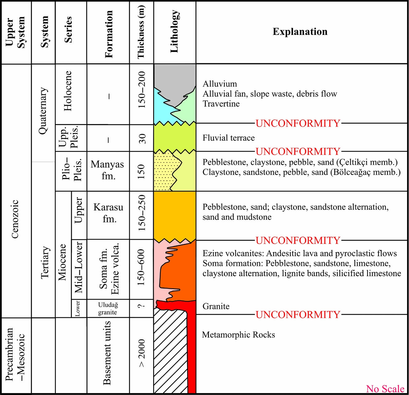
Figure 4. Generalized stratigraphy of the investigation area.
The Uludağ granite, which was first mapped and described by Ketin (Reference Ketin1947), was emplaced into Triassic metamorphic rocks during Early Miocene time (about 17 Ma) and tectonically uplifted just after the emplacement (about 14 Ma; Cavazza, Okay & Zattin, Reference Cavazza, Okay and Zattin2009).
The Ezine volcanites (Fig. 4) consist of extrusive, intrusive and pyroclastic rocks such as andesitic lava, pyroclastic flow deposits, fall-out deposits and ash. According to radiometric age data (Sr isotopic ratios and the K–Ar method) these magmatic and pyroclastic rocks were deposited between 21 and 17.6 Ma (Borsi et al. Reference Borsi, Ferrara, Innocenti and Mazzudi1972; Ercan et al. Reference Ercan, Satir, Kreuzer, Türkecan, Günay, Cevikbas, Ates and Can1985). Based on their geochemical nature, these calc-alkaline magmatic rocks were regarded as post-collisional in origin (Yılmaz et al. Reference Yilmaz, Genc, Gürer, Bozcu, Yilmaz, Karacik, Altunkaynak, Elmas, Bozkurt, Winchester and Piper2000). The Ezine volcanites interfinger with lacustrine deposits of the Soma Formation.
The Soma Formation (Fig. 4) starts with red continental clastic sediments at the base and grades upwards into lignite-bearing lacustrine deposits, such as light-coloured limestones, silicified limestones, marls and claystones. This formation is accepted, in general, as having been deposited under the control of an extensional tectonic regime, but the direction of this extension is controversial. Some authors, such as Şengör (Reference Sengör, Coward, Dewey and Hancock1987) and Yılmaz et al. (Reference Yilmaz, Genc, Gürer, Bozcu, Yilmaz, Karacik, Altunkaynak, Elmas, Bozkurt, Winchester and Piper2000) concluded that this formation was deposited within the NE- and NW-trending cross grabens, which developed as a result of N–S compression prior to development of the present E-trending Aegean graben system (Yılmaz et al. Reference Yilmaz, Genc, Gürer, Bozcu, Yilmaz, Karacik, Altunkaynak, Elmas, Bozkurt, Winchester and Piper2000), while some others such as Sözbilir (Reference Sözbilir2002), Bozkurt & Sözbilir (Reference Bozkurt and Sözbilir2004), Purvis & Robertson (Reference Purvis and Robertson2004) and Çiftçi & Bozkurt (Reference Ciftci and Bozkurt2009) advocated that the Soma Formation was deposited in a lake environment developed during the early stage of the E–W rifting in Western Anatolia. Based on pollen (Yalçınkaya & Afşar, Reference Yalcinkaya and Afsar1980), ostracods (Akyürek & Soysal, Reference Akyürek and Soysal1983), mammal fossils (Bernor & Tobien, Reference Bernor and Tobien1990) and mollusc fauna (Yeşilyurt & Taner, Reference Yesilyurt and Taner1999), a Middle to Late Miocene age was assigned for the deposition of the Soma Formation. Alternatively, the Soma Formation was dated by İnci (Reference Inci1998) as Early–Middle Miocene according to mollusc fauna data.
The Upper Miocene to Recent units of the study area (Fig. 4) developed mainly under the control of normal and strike-slip faults. The Upper Miocene fluvial and fluvio-lacustrine deposits of the Karasu Formation rest unconformably on the older units and are composed of weakly cemented or loose clastic sediments such as pebbles, sands and mudstones. Outcrops of this unit are only seen in the northern part of the study area, on the Bandırma–Mudanya Uplift (see Fig. 3). Palaeocurrent measurements from the pebble imbrications indicate that the source of the formation was in the north, in the present position of the Sea of Marmara. The age of this formation is Late Miocene based on gastropods (Taner, Kapan-Yesilyurt & Isik, Reference Taner, Kapan-Yesilyurt and Isik1997) and mammal fossils (Sichenberg et al. Reference Sichenberg, Becker-Platen, Benda, Berg, Engesser, Gaziry, Heissig, Hinermann, Staesche, Steffens and Tobein1975).
Stratigraphic contacts of the Pliocene–Pleistocene fluvial deposits with the Miocene and older units cannot be seen anywhere in the study area. These units are only deposited within the Bursa–Gönen Depression and they are composed of two clastic members of the Manyas Formation, namely the Bölceağaç and the Çeltikçi members (see Fig. 4). The Bölceağaç Member is represented by matrix-supported clastic sediments while the Çeltikçi Member is represented by grain-supported clastic sediments indicating a higher energy environment of deposition. Both members consist of loose or weakly cemented conglomerates, sandstones and claystones alternating with each other in different ratios. The age of both members, which were deposited within a fluvial system, is probably Late Pliocene – Early Pleistocene, based on correlation with similar units in the Adapazarı area, NW Turkey (Ünay et al. Reference Ünay, Emre, Erkal and Keçer2001).
Quaternary deposits are also only seen within the Bursa–Gönen Depression and they are represented by (a) Upper Pleistocene fluvial terrace deposits and (b) alluvial fan and slope waste deposits developed in front of fault scarps, alluvial clastic sediments deposited along the rivers and travertine (see Fig. 4).
3. Morphology
The Yenice–Gönen, Manyas–Mustafakemalpaşa, Uluabat and Bursa faults forming the southern branch of the NAF controlled the geomorphologic evolution of the Southern Marmara sub-region. The two most prominent geomorphic elements of the study area are the Bandırma–Mudanya and Uludağ–Sularya uplifts in the north and the south of the study area, respectively, and the Bursa–Gönen Depression between them. The Bursa–Gönen Depression can also morphologically be subdivided into, from west to east, the Gönen, Manyas–Karacabey, Uluabat and Bursa basins (see Fig. 2). The Gönen, Manyas, Kocasu, Mustafakemalpaşa and Nilüfer rivers, which are sourced from the Uludağ–Sularya Uplift, flow towards the north, and then run through the Bursa–Gönen Depression (Fig. 3). The Manyas and Uluabat lakes are also two important morphological features of the depression (Fig. 2). The Bandırma–Mudanya Uplift forms a barrier between the Sea of Marmara and the Bursa–Gönen Depression. The Kocasu and Gönen rivers drain the depression into the Sea of Marmara. At the mouth of these rivers large deltas developed (Fig. 3). The Kocasu River connects the depression to the Sea of Marmara in the north via a deep incised gorge that cuts the Bandırma–Mudanya Uplift. This deep gorge was developed as a result of the capturing of the Kocasu River by a small valley in the northern face of the uplift. The Kocasu and Gönen rivers are cut by active faults that delimit the depression, and their courses have been deflected laterally and offset by different amounts. Table 1 lists offsets created by active fault branches in the region (Selim et al. Reference Selım, Tüysüz, Karakas and Tas2012).
Table 1. Displacements on the rivers related to the southern branch of the NAF in the Marmara sub-region

Upper Miocene deposits are absent on the southern uplift, while they rest on the Bandırma–Mudanya Uplift in the north. Similarly, the Pliocene and younger units were deposited only within the Bursa–Gönen Depression and they are absent on both uplifts. In addition, the Pliocene–Pleistocene sediments thicken towards the south, indicating (a) asymmetrical development of the Bursa–Gönen Depression and (b) syntectonic development of these sediments.
4. Active faults
The earthquake activity of the region during the historical and instrumental periods indicates that most of the faults in the study area (see Fig. 2) are active. In the following sections we briefly describe important fault segments in the Southern Marmara sub-region from west to east. All of these faults cut Pliocene–Quaternary units in addition to older basement rocks.
4.a. The Yenice–Gönen Fault
The Yenice–Gönen Fault is an 85 km long en échelon style right-lateral fault zone (Herece, Reference Herece1990). It trends N60–65°E between Yenice district (see Fig. 1) and Kalfaköy Village, then turns in an E–W direction within the Gönen–Manyas plain between Kalfaköy and Ilıcaboğazı (Karaçalılık segment, Figs 3, 5a). The fault lies within the Ezine volcanites in the SW but eastward it cuts the Quaternary units around Balcıköy Village and forms the boundary between the Manyas Formation and Ezine volcanites around Kalfaköy and Saraçlar villages (see Fig. 3). In the west and north of Manyas Lake there are two more segments, the Çalıoba and the Doğruca segments, the directions of which are the same as that of the Yenice–Gönen Fault.

Figure 5. (a) The Yenice–Gönen Fault scarp in the south of Kalfaköy Village (4440000N–562400E). The fault extends in an approximately E–W direction and has a normal character. (b) Normal slip on the Karaçalılık segment (4440343N–594000E) The height of the man standing in front of the fault scarp is about 1.80 m. (c) The Çalıoba segment of the Yenice–Gönen Fault in the Taşocağı (Quarry) location (4447820N–563000E). The segment has right-lateral offset with a reverse component. The height of the car in front of the cut slope is about 1.85 m.
On the SW part of the Yenice–Gönen Fault, between Ilıcaoba and Balcıköy villages, the Gönen River is displaced by the fault about 5.5 km to the right (Fig. 6a). The 18 March 1953 Yenice–Gönen earthquake (Ms = 7.2) occurred on this part of the fault and created 1.5 m pure right-lateral offset around Muratlar Village (Ketin & Roesli, Reference Ketin and Roesli1953) (see Fig. 3). These features indicate that this part of the fault has a pure right-lateral nature and the fault is active. There are 75–85°C hot water springs on this fault, in Ilıcaoba and Ekşidere villages and in the Gönen district (Yalçın, Reference Yalcin and Schindler1997). GPS measurements indicate the rate of movement on the fault as 6.8 ± 2.3 mm yr−1 (Meade et al. Reference Meade, Hager, Mcclusky, Reilinger, Ergintav, Lenk, Barka and Özener2002).

Figure 6. Different river offsets created by active faults. (a) Gönen River (4432110N–546890E); (b) Manyas River (4435350N–577000E); (c) Mustafakemalpaşa River (4432430N–620510E); (d) Nilüfer River (4449790N–667730E). Locations of these faults are given on Figure 3 as letters inside circles: G, M, Mk and N.
The Yenice–Gönen Fault splits into two segments where it enters into the Gönen–Manyas basin. One segment turns to the east, parallel to the Manyas–Mustafakemalpaşa Fault, while the other continues northeastward. Morphological features such as river offsets, fault scarps and kinematic data indicate that the NE-trending western part of the fault is dominantly right lateral, while its E-trending part is dominantly normal in sense (Fig. 7a). A Mw = 4.9 10 July 2008 earthquake occurred on this part of the Yenice–Gönen Fault, the epicentre of which was near Tütüncü Village (Fig. 3) where the fault changes its trend. The fault plane solution of this earthquake indicates an oblique faulting with a dominantly normal component (see Fig. 5).

Figure 7. Kinematic indicators of faults, lower hemisphere; arrows show the movement of the hangingwall (Turner, Reference Turner1953 method). (a) The Karaçalılık segment of the Yenice–Gönen Fault planes and corresponding striations, angle of slickenslides 80–88° northwestward, σ1 = 139°/74°, σ2 = 309°/16.50° and σ3 = 41°/5° (4440740N–590850E). (b) Saitabat segment of the Bursa Fault planes and corresponding striations, angle of slickenslides 88–90° northeastward, σ1 = 45°/66°, σ2 = 311°/1° and σ3 = 220°/24° (4446630N–690312E). (c) Manyas–Mustafakemalpaşa Fault plane and corresponding striations, angle of slickenslides 20–30° southwestward, σ1 = 293°/0°, σ2 = 24°/37° and σ3 = 199°/54°. (d) Alaçam Fault plane and corresponding striations, angle of slickenslides 0–20°, σ1 = 266°/23°, σ2 = 15°/36° and σ3 = 152°/43° (4444115N–692900E).
To the east of Saraçlar Village, the Yenice–Gönen Fault cannot be followed within the loose alluvial deposits but reappears to the south of Karaçalılık Village located to the southeast of Manyas Lake (Figs 3, 5b). This part of the fault is approximately 12 km long and it has an obvious morphology as it forms the contact between the resistant Ezine volcanites and the easily erodible Bölceağaç Member of the Manyas Formation. Damage caused by the 1964 Manyas earthquake (Ms = 6.9; see Fig. 2) was concentrated just north of this fault. This probably indicates that this earthquake was created by this part of the Yenice–Gönen Fault. Fault plane solutions indicate a pure normal faulting. The NE-trending segment of the Yenice–Gönen Fault, the Çalıoba segment, trending parallel to the segment described above, lies between Muratlar and Bakırlı villages with an en échelon style. It forms a restraining step-over and creates a pressure ridge at the Kiremittepe location (Fig. 3). After that, it continues for about 6–7 km to Büyüksoğuklar Village with a N75°E trend. This part of the fault displays an oblique character with right-lateral and reverse components (Fig. 5c). In 1969, a Ms = 5.6 earthquake occurred close to the Gönen district. Taymaz, Jackson & McKenzie (Reference Taymaz, Jackson and McKenzie1991) concluded that this earthquake was created by a reverse fault.
The Çalıoba segment disappears northeastward but another fault segment north of Manyas Lake, the Doğruca segment, has a similar trend to that of the Çalıoba segment. To the south of the Doğruca Fault, two earthquakes (Ms = 5.1 and Mw = 4.8) occurred on 19 June 2003 (KOERI, unpub. data, 2003: Manyas Lake earthquake fault plane solution, http://www.koeri.bound.edu.tr) and 20 October 2006 (NOA, unpub. data, 2006: http://www.gain.noa.gr), respectively (nos 4 and 5 in Fig. 2). Although locations of the epicentres of both earthquakes are controversial, they are probably related to the Doğruca segment or another normal fault trending parallel to it under the waters of Manyas Lake. Fault plane solutions of both earthquakes indicate right-lateral movement with a normal component (nos 5 and 4 in Fig. 2).
4.b. The Manyas–Mustafakemalpaşa Fault
The Manyas–Mustafakemalpaşa Fault starts from Tütüncü Village in the west and trends eastward for about 70 km through Manyas district to the east of Mustafakemalpaşa district (Fig. 3). The Manyas–Mustafakemalpaşa Fault cuts the Soma Formation and the Ezine volcanites in the west. Eastward, the fault forms the contact between the basement rocks in the south and Quaternary deposits in the north (Fig. 8a). The Manyas River is offset by this fault by about 4.5 km (Figs 3, 6b). In its eastern part, the fault also offsets the Mustafakemalpaşa River 1125 m to the right (Fig. 6c). At the Mezarlıktepe location, near Çeltikçi Village, some antithetic faults cutting the Pliocene–Pleistocene Çeltikçi Member of the Manyas Formation have also been observed (Fig. 8b). Similar to the Yenice–Gönen Fault, there are many hot and cold water springs along the Manyas–Mustafakemalpaşa Fault, such as at Serpin, where temperatures of the hot water reach 50–55°C (Yalçın, Reference Yalcin and Schindler1997). The Serpin spring is located in area where the E-trending Manyas–Mustafakemalpaşa Fault coincides with the N20°E-trending Darıca segment (see Fig. 3).

Figure 8. (a) Fault plane of the Manyas–Mustafakemalpaşa Fault near Tütüncü Village; the fault cuts the Middle Miocene Soma Formation (4437500N–560000E). The height of the man standing in front of the fault plane is about 1.80 m. The length of the pen on the fault plane is about 15 cm. (b) The Manyas–Mustafakemalpaşa Fault cuts the Pliocene–Pleistocene Çeltikçi Member in Çeltikçi Village near the Mezarlıktepe location; antithetic faults developed in the hangingwall (4435216N–504000E).
The Manyas–Mustafakemalpaşa Fault plane was clearly observed in two places. Near Tütüncü Village the fault cuts the Soma Formation. Its strike is N65°E and dip is 47°NW. The pitch of the striations of the slickenlines on the fault plane indicate right-lateral offset with a 20° reverse component (Fig. 7c). Near the Mezarlıktepe location, to the south of Çeltikçi Village, the fault plane is directed N50°W and dips 23°NE.
4.c. The Uluabat Fault
This fault is the most linear and morphologically obvious fault in the region. The uplifted footwall of the Uluabat Fault is known as the Söğütalan plateau, with an attitude reaching up to 800 m above sea level. The northern downthrown block of the fault forms the central part of the Bursa–Gönen Depression (Figs 3, 9).
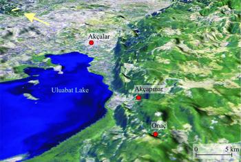
Figure 9. Digital elevation model of the Uluabat Fault and the surrounding area (Landsat TM full band at 26 September 1999).
The westernmost segment of this fault, the Yumurcaklı segment, trends E–W and is 15 km long. This fault forms a boundary between Quaternary units and Ezine volcanites. It right-laterally displaced the Melde Creek by 250 m (see Fig. 3). To the south of Uluabat Lake the fault turns to 60–65°NE. In this area the fault consists of two parallel segments. The northern one forms the contact between the basement units in the south and the Quaternary lake deposits in the north, while the southern one cuts only the basement units (Fig. 3). It is possible to clearly see fault facets and scarps as well as en échelon structures along these faults. The southern segment displaced the Dorak and Orak creeks about 250 m right laterally. Similar offsets reaching up to 500 m near Balat Creek have been observed along the fault (Fig. 10). There are large alluvial fans along the northern segment. Both faults step over in two places to the south of Apolyont Lake, near Onaç and Akçapınar villages. Although there is no knowledge of earthquakes produced by this fault during the instrumental and historical periods, Şaroğlu, Boray & Emre (Reference Saroglu, Boray and Emre1987) accepted the Uluabat Fault as an active fault, as it is located within an active system. Öztin & Bayülke (Reference Öztin and Bayülke1990) also claimed that the epicentre of the 1855a earthquake (Io = X) was very close to the Uluabat Fault zone.

Figure 10. The southern segment of the Uluabat Fault displaced Balat Creek by about 500 m right laterally (4443815N–643500E). The height of the man standing in the photo is about 1.85 m.
4.d. The Bursa Fault
The Bursa Fault consists of four segments: Kayapa–Çalı, Misiköy, Çekirge–Hamamlıkızık and Saitabat from west to east (Figs 2, 3). The Kayapa–Çalı segment extends about 12 km between Kayapa and Çalı villages in an E–W direction. It trends about N70°W near Çalı Town. To the north of the Kayapa dam the fault forms a contact between metamorphic units in the footwall and Neogene deposits in the hanging wall. Fault scarps, alluvial fans and lined-up water springs along the fault are morphological expressions of the Kayapa–Çalı segment. As the fault did not create any offset on the rivers that it cuts, we accept this segment as pure normal in character.
The Misiköy segment, which was first described by Tanoğlu & Erinç (Reference Tanoglu and Erinc1957), is approximately 12 km long and trends in a N40–45°E direction. The Misiköy segment created a distinct morphology (Fig. 11) consisting of fault scarps, triangular facets and river offsets. A 2300 m right-lateral offset of the Nilüfer River (Fig. 6d) was also attributed to this fault and capture associated with the fault offset (Tanoğlu & Erinç, Reference Tanoglu and Erinc1957). It also clearly offset the Hisarlık and Kana creeks to the right. To the east of Çalı Town, the Misiköy segment forms the contact between alluvium and metamorphic basement, while it forms the contact between the Soma Formation and re-crystallized limestone of the basement rocks to the north of Misiköy Village.
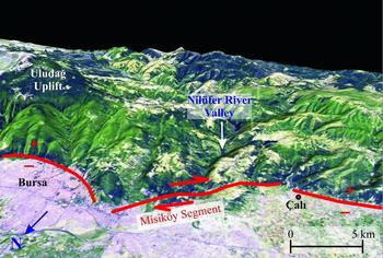
Figure 11. Digital elevation model of the Misiköy segment of the Bursa Fault, Nilüfer River, Misiköy Strait and its surrounding area (Landsat TM full band at 26 September 1999).
The Çekirge–Hamamlıkızık segment forms the northern boundary of the Uludağ–Sularya Uplift and lies between Çekirge and Hamamlıkızık villages (Fig. 3). This segment starts in the west near Çekirge, where it trends here in a N30°W direction. Eastward, near Çukuryayla Creek, it turns to the east (Fig. 12). The segment forms a sharp boundary between metamorphic rocks in the footwall in the south and Quaternary deposits on the hanging wall to the north. This segment also has a clear fault morphology consisting of fault scarps and fault facets and alluvial fans (Fig. 13). Along the Kaplıkaya Creek, the fault plane dip is 50° to the north. There are hot springs in Çekirge along this fault. The Saitabat segment lies between Hamamlıkızık and Sayfiye villages (see Fig. 3). The fault plane trends N60°W and dips to the northeast by 35°. Slickenlines and corrugations on the fault plane indicate that the Saitabat segment has a pure normal character (Figs 7b, 14a). To the north of Saitabat segment, there are two more segments trending parallel to it. They are named the Kestel and Deliçay segments and both display a right-lateral character. The possibly inactive Alaçam Fault, located southeast of the Uludağ–Sularya Uplift, was cut by the Saitabat segment. Striations, corrugations and slickenlines on the fault indicate a pure right-lateral nature (Figs 7d, 14b).

Figure 12. Morphotectonic map of the Bursa Fault.
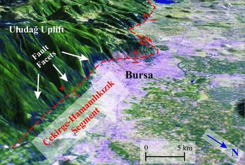
Figure 13. Digital elevation model of the Bursa Fault from east to west (compiled from Landsat TM full band at 26 September 1999).

Figure 14. (a) Illustration of slickenslides of the Saitabat segment of the Bursa Fault (4446630N–690312E). The height of the man standing on the fault plane is about 1.80 m. The length of the hammer on the fault plane is about 30 cm. (b) Illustration of slickenslides of the Alaçam Fault (4444115N–692900E).
At least one of two devastating earthquakes that occurred in 1855 was probably produced by the segments of the Bursa Fault. In addition, hot water springs, such as Kükürtlü, Çekirge and Hamamlıkızık, 60 m thick Bursa travertine along the Çekirge–Hamamlıkızık segment, and several alluvial fan deposits, slope wastes and debris flows indicate that the Bursa Fault is an active fault.
5. Seismicity of the Southern Marmara sub-region
Although there are uncertainties regarding their epicentre locations, historical and instrumental earthquakes in the Southern Marmara sub-region were located mainly on the Yenice–Gönen, Manyas, Mustafakemalpaşa, Uluabat and Bursa faults in the south and on the İznik–Gemlik, Bandırma, Sarıköy and Çifteçeşmeler–Edincik faults in the north (see Fig. 2). During the historical period, between the years 33 and ad1899, there were many well-known destructive earthquakes, the most significant of which occurred in 170, 543, 1851 and 1855. The 170 and 543 earthquakes occurred in the Erdek–Bandırma area (see Fig. 3). It is generally believed that the 28 February 1855 earthquake (Io = IX; Ambraseys & Finkel, Reference Ambraseys and Finkel1991) occurred on the Uluabat Fault and the 11 April 1855 earthquake (Io = X; Sandison, Reference Sandison1855; Sieberg, Reference Sieberg and Gutenberg1932) occurred on the Bursa Fault (see Fig. 2).
During the instrumental period, the 1953 Yenice–Gönen, 1964 Manyas and 1969 Gönen earthquakes occurred on the Yenice–Gönen Fault. No destructive earthquake has occurred in the region since 1976. However, two moderate earthquakes (Ms = 5.1) on 9 June 2003 and (Mw = 4.8) at 20 October 2006 occurred in the Manyas Lake area. In addition, another moderate event (Mw = 4.9) occurred on 10 July 2008 (KOERI, unpub. data, 2008: Gönen (Tütüncü) earthquake fault plane solution, http://koeri.boun.edu.tr) on the southern segment of the Yenice–Gönen Fault near Tütüncü Village. Moment tensor solutions of these instrumental earthquakes are given on Figure 2.
5.a. GPS measurements
Recently, many GPS studies have been conducted in the Anatolian Block and in the Marmara region, particularly after the two big earthquakes that occurred in the Marmara region in 1999 (Kahle et al. Reference Kahle, Cocard, Peter, Geiger, Reilinger, Barka and Veis2000; McClusky et al. Reference McClusky, Balassanian, Barka, Demir, Ergintav, Georgiev, Gürkan, Hamburger, Hurst, Kahle, Kastens, Kekelidze, Kotzev, Lenk, Mahmoud, Mishin, Nadaria, Ouzounis, Paradissis, Peter, Prilepin, Reilinger, Sanli, Seeger, Teableb, Toksöz and Veis2000, Reference McClusky, Reilinger, Mahmoud, Ben Sari and Teableb2003; Reilinger et al. Reference Reilinger, McClusky, Paradissis, Ergintav and Vernant2010). According to these GPS data, the Anatolian Block escapes westward along the Northern and Southern Anatolian transform faults and rotates anticlockwise around a pole in the Sınai Peninsula. Different rates of movement along the NAF have been proposed, such as 5–10 mm yr−1 (Barka, Reference Barka1992), 30–40 mm yr−1 (Taymaz, Jackson & McKenzie, Reference Taymaz, Jackson and McKenzie1991), 17 ± 2 mm yr−1 (Westaway, Reference Westaway1994), 15–25 mm yr−1 (Reilinger et al. Reference Reilinger, McClusky, Oral, King and Toksöz1997; Meade et al. Reference Meade, Hager, Mcclusky, Reilinger, Ergintav, Lenk, Barka and Özener2002), 24 ± 2 mm yr−1 (McClusky et al. Reference McClusky, Balassanian, Barka, Demir, Ergintav, Georgiev, Gürkan, Hamburger, Hurst, Kahle, Kastens, Kekelidze, Kotzev, Lenk, Mahmoud, Mishin, Nadaria, Ouzounis, Paradissis, Peter, Prilepin, Reilinger, Sanli, Seeger, Teableb, Toksöz and Veis2000) and ~ 25 mm yr−1 (Reilinger et al. Reference Reilinger, McClusky, Paradissis, Ergintav and Vernant2010). GPS measurements indicate that the rates of the southern and northern branches of the NAF are different. Armijo et al. (Reference Armijo, Meyer, Navarro, King and Barka2002) concluded that the rate of the northern segment is 24–25 mm yr−1, while the rate of the southern branch is only 2–3 mm yr−1 (Straub & Kahle, Reference Straub and Kahle1995) or ~ 4–5.5 mm yr−1 (Reilinger et al. Reference Reilinger, McClusky, Paradissis, Ergintav and Vernant2010). Meade et al. (Reference Meade, Hager, Mcclusky, Reilinger, Ergintav, Lenk, Barka and Özener2002) calculated the rate of the southern branch of the NAF by using the fixed DEMI point (longitude: 27.78°E; latitude: 41.83°N) in the northwest of the Thrace Region. For the Yenice–Gönen Fault they gave the rate of 6.8 ± 2.3 mm yr−1 for the strike-slip and 0.8 ± 3.4 mm yr−1 for the normal offset. On the other hand, the rates of the south segment of theYenice–Gönen, Manyas–Mustafakemalpaşa and Bursa faults are calculated as 3.6 ± 2.0 mm yr−1 for strike-slip and 8.0 ± 4.3 mm yr−1 for normal offset. In addition, the right-lateral strike-slip rate is 9.6 ± 2.6 mm yr−1 and the extension rate is 5.9 ± 4.3 mm yr−1 for the Kestel segment (Fig. 15). These data support the characteristics of the faults described above and imply that these segments are still active.

Figure 15. GPS measurements of the southern branch of the North Anatolian Fault, according to the DEMI point in northwestern Thrace (Meade et al. Reference Meade, Hager, Mcclusky, Reilinger, Ergintav, Lenk, Barka and Özener2002).
6. Tectonic model and discussion
In the study area there two types of faults: (a) mainly NE-trending pure or dominantly strike-slip (right-lateral) faults, such as the Çifteçeşmeler–Edincik, Bandırma, Sarıköy, Yenice–Gönen, Uluabat and Misiköy faults, and (b) mainly E-trending normal, or dominantly normal oblique faults, such as the South Marmara Fault, southern segment of the Yenice–Gönen Fault, the Karaçalılık segment and the Bursa Fault.
In addition to our field observations on the kinematic and morphological indicators, fault plane solutions for the earthquakes on the NE-trending faults indicate their right-lateral nature (see Fig. 2). For example, the 1953 Yenice–Gönen (McKenzie, Reference McKenzie1972), 2003 and 2006 Manyas Lake (KOERI, unpub. data, 2003: Manyas Lake earthquake fault plane solution, http://www.koeri.bound.edu.tr; NOA, unpub. data, 2006: http://www.gain.noa.gr) and 2008 East of Gönen (KOERI, unpub. data, 2008: Gönen (Tütüncü) earthquake fault plane solution, http://koeri.boun.edu.tr) events’ fault plane solutions all indicate right-lateral faulting. Some direct field observations of the occurrence of reverse faulting (4447820N–563000E Çalıoba segment) and the 1969 Gönen earthquake's fault plane solution also display a reverse component (Taymaz, Jackson & McKenzie, Reference Taymaz, Jackson and McKenzie1991) along the NE-trending faults. In contrast to the NE-trending faults, fault plane solutions of E-trending faults, for example the 1964 Manyas earthquake, which caused damage to the south of Manyas Lake, indicates normal faulting (Taymaz, Jackson & McKenzie, Reference Taymaz, Jackson and McKenzie1991). However, the fault plane solution of the earthquake (Ms = 5.1) that occurred approximately 1.5 minutes earlier than the main shock indicates right-lateral offset with a normal component (Kıyak, Reference Kiyak1986). These data also support our field observations that the E-trending faults have a mainly normal or transtensional character, while the NE-trending faults display a right-lateral transpressional character, and that both are still active. Based on the nature of the faults in the study area, and data from the Sea of Marmara to the north, we propose a tectonic model for the development of the uplifts and depressions in the Southern Marmara sub-region (Fig. 16).

Figure 16. Tectonic evolution of the Bursa–Gönen Depression. (1) By the development of right-lateral deformation small pull-apart basins start to open. Apolyont and Manyas lakes emplaced into the deepest parts of these basins. (2) In the later stages of the development (during the Late Pliocene–Pleistocene?) pull-apart basins enlarged and joined to form the Bursa–Gönen Depression, which is delimited and cut by active (red) and inactive (black) faults.
The study area is located in a region where two active tectonic systems act: the Aegean extensional regime and the right-lateral NAF. Although the mechanism and timing of the beginning of the Aegean extensional system is controversial (see Bozkurt, Reference Bozkurt2001 for this discussion), there is no doubt that E–W extension has been active since the Pliocene in the whole of Western Anatolia, as indicated by many authors (see Bozkurt, Reference Bozkurt2001 and references therein) and GPS measurements (Reilinger et al. Reference Reilinger, McClusky, Paradissis, Ergintav and Vernant2010). In most of the E–W-trending grabens of Western Anatolia, the Pliocene witnessed deposition of clastic sediments under the control of normal faults delimiting the grabens (Görür et al. Reference Görür, Sengör, Sakinc, Tüysüz, Akkök, Yigitbas, Oktay, Barka, Sarica, Ecevitoglu, Demirbag, Ersoy, Algan, Güneysu and Aykol1995; Tüysüz, Barka & Yigitbas, Reference Tüysüz, Barka and Yigitbas1998; Çiftçi & Bozkurt, Reference Cavazza, Okay and Zattin2009; Öner & Dilek, Reference Öner and Dilek2011). In the light of this tectonic framework, it can be concluded that during Pliocene time an extensional regime was effective in the study area and surroundings. On the other hand, fission-track data indicating exhumation and uplifting of the Uludağ–Sularya region 14 Ma (Cavazza, Okay & Zattin, Reference Cavazza, Okay and Zattin2009) also support this idea.
The Sea of Marmara region, to the north of the study area, is thought to have been a gateway between the Paratethys and the Mediterranean since the Middle Miocene (Çağatay et al. Reference Cagatay, Görür, Flecker, Sakinc, Tünoglu, Ellam, Krijgsman, Vincent and Dikbas2006). While lacustrine deposition was continuing on the continental parts of Western Anatolia, Mediterranean marine transgressions affected coastal areas of the northern Aegean and the western part of the Sea of Marmara during the Late Serravallian (about 12 Ma; IUGS, 2012, http://www.stratigraphy.org). These marine incursions also continued during the Tortonian (11.6–7.2 Ma; IUGS, 2012, http://www.stratigraphy.org) and Messinian (7.2–5.3 Ma; IUGS, 2012, http://www.stratigraphy.org), but there was no connection between the Mediterranean and the Sea of Marmara during the Zanclean (5.3–3.6 Ma; IUGS, 2012, http://www.stratigraphy.org) until the Late Pliocene (Çağatay et al. Reference Cagatay, Görür, Flecker, Sakinc, Tünoglu, Ellam, Krijgsman, Vincent and Dikbas2006), when re-connection was established by the activity on the NAF.
The geology of the southern shelf of the Sea of Marmara, which is known as the Southern İmralı Basin (Okay et al. Reference Okay, Kaslilar-Ozcan, Imren, Boztepe-Guney, Demirbag and Kuscu2000, Reference Okay, Mater, Artüz, Gürseler, Artüz, Okay and Levent Artüz2007), can clearly be correlated with the study area. The Southern İmralı Basin is a 40 km long shelf lying about 110 m below present sea level. The İmralı and Marmara islands are located on this shelf and are mainly composed of Upper Cretaceous and older basement rocks. A gently S-dipping and southwards thickening sedimentary sequence unconformably overlies this basement. The thickness of these sediments reaches up to 1 km towards the south where an E–W-trending fault separates this basin from the Bandırma–Mudanya Uplift. In the northern part of this basin, basement rocks and an unconformably overlying sedimentary sequence crop out on İmralı island (Erguvanlı, Reference Erguvanli1949).
The Southern İmralı Basin is separated from the Northern İmralı Basin by another E–W-trending fault, the Southern Boundary Fault (Okay et al. Reference Okay, Kaslilar-Ozcan, Imren, Boztepe-Guney, Demirbag and Kuscu2000). Based on seismic data Okay et al. (Reference Okay, Kaslilar-Ozcan, Imren, Boztepe-Guney, Demirbag and Kuscu2000) concluded that the sedimentary sequence filling this basin consists of two sedimentary packages: a deformed Upper Miocene – Lower Pliocene lower unit and a less-deformed sedimentary unit overlapping the lower one.
The Marmara-1 well drilled in the western part of the Northern İmralı Basin cut Upper Miocene (?) – Pliocene limnic to fluvio-deltaic sediments, 2100 m in thickness below a thin (40 m) Quaternary marine siliciclastic sequence (Ergün & Özel, Reference Ergün and Özel1995). These sediments can be compared with the fill of the Southern İmralı Basin and the Karasu Formation in the Bursa–Gönen Depression. In the Marmara-I well these sediments unconformably overlie Maastrichtian limestones; the same relationship was also observed on İmralı Island (Erguvanlı, Reference Erguvanli1949).
The distribution and nature of the Upper Miocene and Pliocene sediments around the Marmara Sea indicate that the Marmara Sea was a large lake surrounded by erosional areas at that time (Görür et al. Reference Görür, Cagatay, Sakinc, Sümengend, Sentürk, Yaltirak and Tchapalyga1997; Sakınç, Yaltirak & Oktay, Reference Sakinc, Yaltirak and Oktay1999) and continental clastic sediments were depositing along the margins of this lake. As the thickness of these sediments increases towards the south, where faults delimit the basins, it can be interpreted that they were deposited on tilted fault blocks under the control of faults delimiting these blocks. Based on these data, we suggest that during Late Miocene – Pliocene time, the Southern Marmara region, including our study area, was under the influence of an extensional tectonic regime, causing the development of a series of half grabens facing to the south.
In the study area, the fluvio-lacustrine Karasu Formation is seen only on the Bandırma–Mudanya Uplift. Palaeocurrent directions and the southward thickening nature of this unit indicate the occurrence of an erosional area, the Bandırma–Mudanya Uplift, separating the Bursa–Gönen Depression and the Southern İmralı Basin during the deposition of the Karasu Formation (Fig. 17).

Figure 17. Development of the Upper Miocene (Karasu Formation) – Pliocene (Çeltikçi Member) deposits in the Marmara region.
The NAF is believed to have nucleated during Late Miocene time in the east and propagated westwards, reaching the Aegean region probably during Pliocene time (Tüysüz, Barka & Yigitbas, Reference Tüysüz, Barka and Yigitbas1998; Şengör et al. Reference Sengör, Tüysüz, Imren, Sakinc, Eyidogan, Görür, Le Pichon and Rangin2004). Le Pichon et al. (Reference Le Pichon, Sengör, Demirbag, Rangin, Imren, Armijo, Görür, Cagatay, Mercier De Lepinay, Meyer, Saatcilar and Tok2001, Reference Le Pichon, Chamot-Rooke, Rangin and Sengör2003) concluded that the present course of the NAF in the Sea of Marmara originated 200 ka ago.
Activity on the NAF probably started during the Late Pliocene – Early Pleistocene period in the interpretation of this study. This interpretation is based on the occurrence of Late Villanian – Early Biharian (Late Pliocene – Early Pleistocene) alluvial fan deposits along the southern border of the Bursa–Gönen Depression. These deposits cannot be seen in the northern part of the depression, which indicates that the fault was active in the south at that time.
The Plio-Pleistocene sediments are restricted to the Bursa–Gönen Depression and they are absent on the uplifts delimiting the depression in the north and south. The thickness of these sediments increases southward, where they are cut by active faults. Southward thickening of these sediments probably indicates the asymmetric subsidence of the depression owing to faults along the southern margin of the depression and syntectonic deposition of these sediments within the depression. Based on the fault geometry and the stratigraphy described above, we propose that during Late Miocene – Pliocene time the Bandırma–Mudanya and Uludağ–Sularya uplifts developed as tilted en échelon fault blocks, probably under the control of the Western Anatolian Extensional tectonic regime. A right-lateral system was probably emplaced into this disrupted morphology since the Late Pliocene. E- and NE-trending tensional and transtensional fault segments in the study area are probably inherent structures of a previous extensional regime.
According to our model, the strike-slip system started to affect the Southern Marmara region during the deposition of the Manyas Formation, possibly during the Late Pliocene. Şengör et al. (Reference Sengör, Tüysüz, Imren, Sakinc, Eyidogan, Görür, Le Pichon and Rangin2004) proposed that the NAF started in the east and reached Western Anatolia during Pliocene time. This strike-slip system used the previous fault geometry and created several basins extending in an NE–SW direction (see Fig. 16). Some of these basins were opened as pull-apart basins (Selim, Reference Selim2004). The pure strike-slip, normal component strike-slip and normal faults are connected to each other. The pure right-lateral faults linked to the NAF worked as transfer faults in the region while the right-lateral strike-slip faults with a normal component and normal faults contributed to the opening of the pull-apart basins. The Manyas and Uluabat lakes were emplaced within the deepest parts of the study area. It can be interpreted that they were developed in the earlier phase of the development of the Bursa–Gönen Depression. In the later stage, these small pull-apart basins enlarged and joined to form a single Bursa–Gönen Depression delimited by two uplifts on both sides.
The Gönen Basin, among the other basins, can be defined as a symmetrical pull-apart basin according to the analogue classification of Rahe, Ferrill & Morris (Reference Rahe, Ferrill and Morris1998). Other basins such as the Manyas–Karacabey, Uluabat and Bursa developed as asymmetrical pull-apart basins according to Rahe, Ferrill & Morris's (Reference Rahe, Ferrill and Morris1998) classification. The Bursa–Gönen Depression has been filled with alluvial materials since the Quaternary. The Çifteçeşmeler–Edincik, Bandırma and Sarıköy faults form the onshore continuation of the southern branch of the NAF, which are right-lateral strike-slip faults (Figs 2, 3).
7. Conclusions
The NAF is a single-strand fault in its eastern part but it splits into different branches in the west. The northern branch, which is the fastest-moving branch of the fault, strikes through the northern part of the Sea of Marmara. The other branch extends through Pamukova–Gemlik and enters the Sea of Marmara in the Gulf of Gemlik. In contrast to these rather continuous faults, the southernmost branch of the NAF following the Bursa–Gönen Depression has a more segmented nature and includes NE- and E-trending faults. The NE-trending faults are right-lateral with a local compressional component, while the E-trending faults are mainly normal faults with a right-lateral component.
The Bursa–Gönen Depression is delimited by the Bandırma–Mudanya Uplift in the north and the Uludağ–Sularya Uplift in the south, and is filled by Upper Pliocene to Recent fluvial deposits. Southward thickening of these sediments and the absence of them on the uplifts imply the asymmetric opening of the Bursa–Gönen graben and deposition under the control of the southernmost branch of the NAF.
In the light of the stratigraphic units and the fault geometry, we propose a tectonic model for the development of the region. According to this model, the Bursa–Gönen Depression opened during the Late Miocene to Pliocene together with the Sea of Marmara basin as asymmetric tilted fault blocks under the control of an Aegean extensional tectonic regime. The NAF has been emplaced into this weak and faulted region since Late Pliocene time. This right-lateral fault system was probably forced to gain a serrated geometry by older normal faults and transfer faults connecting them. As a result of this serrated geometry, some pull-apart basins developed and they evolved into a single Bursa–Gönen Depression. In this study we could not find any age data for the formations filling the depression, which is crucial to test the model we propose. This would be a subject of a future study.
The morphology of the Southern Marmara sub-region also developed under the control of the active faults. In addition to the development of uplifts and depressions in the region, the faults caused offsets of the rivers. For example, the maximum displacement on the Yenice–Gönen Fault was measured as 5.5 km, while the Manyas–Mustafakemalpaşa Fault displaced the Manyas River 4.5 km and the Mustafakemalpaşa River 1125 m, and the Misiköy segment displaced the Nilüfer River 2.3 km right laterally (Selim et al. Reference Selım, Tüysüz, Karakas and Tas2012).
Devastating earthquakes hit the region during the historical period. During the instrumental period, the 1953 Yenice–Gönen earthquake occurred on the north segment of the Yenice–Gönen Fault, the 1964 Manyas earthquake on the south segment of the Yenice–Gönen Fault and the 1969 Gönen earthquake on the north segment of the Yenice–Gönen Fault. This shows that the region is still under an important seismic risk.
Acknowledgements
We would like to extend our sincere gratitude to the memory of Prof. Dr A. Aykut Barka (Istanbul Technical University) for his valuable contributions to the field observations. We are also indebted to Dr Onur Tan (Tübitak-MAM) for the GMT maps and K. Ömer Taş (Istanbul Technical University) for study support.


