1. Introduction
The Mohe Basin is located in the northeast of China, which has huge hydrocarbon generation potential (Wu, Wang & Yang, Reference Wu, Wang and Yang2004). Previous studies showed that the Mohe Basin was formed under the influence of the closure of the ancient Okhotsk Ocean (He et al. Reference He, Li, Mo and Sorokin2003; Hou et al. Reference Hou, Liu, He, He and Zhang2010a ,Reference Hou, Liu, He, He, Zhang and Zhang b ). The formation ages and the basin trends of the Mohe Basin are markedly different from the other basins in the northeast of China. These characteristics indicate that there are different formation mechanisms between the Mohe Basin and the other basins in this area (He et al. Reference He, Li, Mo and Sorokin2003; Hou et al. Reference Hou, Liu, He, He and Zhang2010a ,Reference Hou, Liu, He, He, Zhang and Zhang b ). Therefore, studies on the Mohe Basin can provide the basis for research on the regional tectonic evolution history and basin analysis in this area.
The Emuerhe Formation is the most important sedimentary deposit of the Mohe Basin. The basin's expansion and the sedimentary thickness accumulated during the deposition of the Emuerhe Formation are both the largest (Xin, Wu & Yang Reference Xin, Wu and Yang2003). Hence, the Emuerhe Formation can act as an important record for the study of the tectonic attributes of the source areas and the sedimentary evolution history of the Mohe Basin. Previous studies have made some achievements in discerning the sedimentary features and source provenance of the whole of the Upper Jurassic through the use of field outcrops, geochemistry and seismic analyses (Zhang et al. Reference Zhang, Lin, Wu and Yang2003; Wu et al. Reference Wu, Feng, Yang, Wang, Zhang and Guo2006; He, Wang & Hou, Reference He, Wang and Hou2008; Hou et al. Reference Hou, Liu, He, He and Zhang2010a ,Reference Hou, Liu, He, He, Zhang and Zhang b ;). However, they did not clarify the source areas of the Emuerhe Formation. In addition, they did not study the uplift rate and the tectonic attributes of the source areas or the transportation distance of the clastic rocks. Sandstone petrography is of great significance in the study of the formation mechanisms of basins and the tectonic evolution history of the source areas (Morton & Hallsworth, Reference Morton and Hallsworth1994; Gray & Zeitler, Reference Gray and Zeitler1997; Yan et al. Reference Yan, Lin, Wang and Guo2002; Marenssi, Net & Santillana, Reference Marenssi, Net and Santillana2002). In this work, the tectonic implications (source areas of each section, tectonic attributes and uplift rate of the source areas, transportation distance of clastic sediments, and attributes of the Mohe Basin) of the sandstone composition of the Emuerhe Formation can be analysed through the sandstone petrography of the selected samples. Thus, the geodynamic and palaeogeographic significance of this region can be interpreted.
2. Geological setting
The Mohe Basin is located to the north of the Ergun massif and to the south of the Okhotsk orogenic belt. Many E–W-trending faults were developed in the Mohe Basin. However, S–N-trending faults were rarely developed in it. This phenomenon may be caused by the collision of the Ergun massif and the Okhotsk orogenic belt. The entire succession of the Mohe Basin is constituted by a sedimentary cover overlying the basement rocks. The basement rocks are mainly composed of the metamorphic rocks of the Proterozoic Xinghuadukou Group, the sedimentary rocks of the Devonian Niqiuhe Formation and Palaeozoic granite. The sedimentary cover is mainly composed of Upper Jurassic terrigenous clastic rocks (the Xiufeng Formation, the Ershierzhan Formation, the Emuerhe Formation and the Kaikukang Formation) and Cretaceous volcanic rocks (Wu et al. Reference Wu, Yang, Huang and Liu2003; Xin, Wu & Yang, Reference Xin, Wu and Yang2003). The Upper Jurassic Emuerhe Formation is mainly composed of terrigenous clastic rocks. Its lower part is mainly composed of fine sandstone, medium-grained sandstone and coarse sandstone sometimes interbedded with conglomerate and siltstone, and the upper part is mainly composed of fine sandstone, medium-grained sandstone and mudstone. Some coarse sandstone interlayers occasionally occur. Some gastropods, ostracods, plants and sporopollen fossils can be found in this formation. In addition, the Emuerhe Formation is mainly distributed in the Laogou, Beijicun, Xingan, Ershiwuzhan and Shuanghezhan areas (Fig. 1).
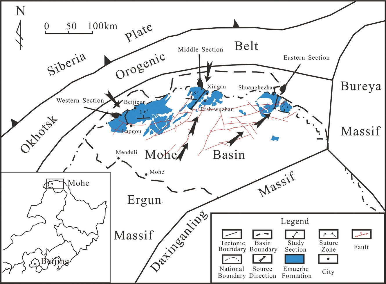
Figure 1. Geological sketch maps of the studied area with location of the studied sections (modified from Xie, Reference Xie2000; Hou et al. Reference Hou, Liu, He, He, Zhang and Zhang2010 a).
3. Methodology
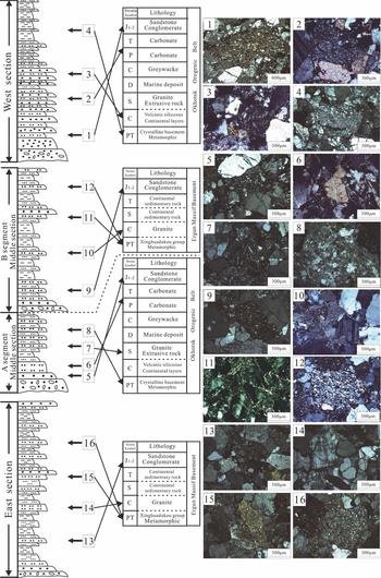
According to the characteristics of the Emuerhe Formation in the Mohe Basin, three stratigraphic sections were selected as the study areas, respectively named the western section, the middle section and the eastern section. The main sedimentary facies of these sections are lake facies and fan delta facies. The western section is 872 m thick. Its lower part is mainly constituted by medium–coarse-grained sandstone sometimes interbedded with fine sandstone. The upper part is mainly constituted by fine sandstone and mudstone. The middle section is 1186 m thick. Its lower part is mainly constituted by fine sandstone, medium-grained sandstone and coarse sandstone. The upper part is mainly constituted by fine sandstone and mudstone. The eastern section is 947 m thick. Its lower part and upper part are all mainly constituted by fine sandstone and medium-grained sandstone sometimes interbedded with mudstone. The sampling locations are shown in Figure 2.

Figure 2. Stratigraphic sections of the Emuerhe Formation with location of the studied samples.
Twelve, sixteen and nine sandstone samples were collected from the western section, the middle section and the eastern section, respectively. The rock types of the samples collected from the Emuerhe Formation sections are mainly fine sandstones, medium-grained sandstones and coarse sandstones. On average, over 350 points were counted in each thin-section. The modal composition data obtained from the Emuerhe Formation samples are given in Table 1. All the samples are classified after Folk (Reference Folk1974).
Table 1. Sandstone composition of the Emuerhe Formation in the Mohe Basin

Symbols: Qm – monocrystalline quartz; Qp – polycrystalline quartz; Qt – total quartzose grains (Qm+Qp); P – plagioclases; K – K-feldspar; F – total feldspar grains (P+K); Lv – volcanic–metavolcanic rock fragments (Lvextrusive+Lvintrusive); Lvextrusive – extrusive rock fragments; Lvintrusive – intrusive rock fragments; Ls – sedimentary rock fragments; Lm – metasedimentary rock fragments; L – lithic fragments (Lv+Ls+Lm). Lt – (Lv+Ls+Lm+Qp).
4. Sandstone petrology and detrital modes
The sandstone grains of the western section samples are angular and sub-angular, and are moderately sorted. The grain size is 0.5–1.2 mm. Matrix content is 3–6%. The sandstones are grain-supported, ranging from arkose to lithic arkose (Figs 3a, b, 4a). The quartz content ranges from 27.6% to 47.8% (average = 36.5%). Monocrystalline quartz is present in a higher percentage than polycrystalline quartz. The feldspar content ranges from 38.8% to 48.6% (average = 44.3%), and is composed of K-feldspar and plagioclases. Plagioclases and K-feldspar are present in equal amounts. Some detrital feldspar was partially dissolved and/or replaced by kaolinite or sericite. The rock fragment content (Lv+Ls+Lm) ranges from 13.4% to 24% (average = 19.23%), and is mainly sandstone debris, carbonate debris, andesite debris and mylonite debris. Among these three types of rock fragments, the percentage of igneous rock fragments is the highest. The percentage of sedimentary rock fragments is smaller than the former. The percentage of metamorphic rock fragments is the lowest.

Figure 3. Photomicrographs of sand grains of the Emuerhe Formation: (a) lithic arkose sandstones from the western section; (b) arkosic sandstones from the western section; (c) arkosic sandstones from the middle section; (d) lithic arkose sandstones from the middle section; (e) arkosic sandstones from the eastern section; (f) arkosic sandstones from the eastern section. (Q – quartz; Pl – plagioclase; Mi – microcline.)

Figure 4. Mineralogical classification of the Emuerhe Formation sandstones based on the Folk diagram (1974): Q – total quartz; F – feldspar; R – rock fragments. I – quartz sandstone; II – feldspathic quartz sandstone; III – lithic quartz sandstone; IV – arkosic sandstone; V – lithic arkose sandstone; VI – feldspar lithic sandstone; VII – lithic sandstone. The rock classification names are modified from Zeng & Xia (Reference Zeng and Xia1998) and Lu & Sang (Reference Lu and Sang2002). Figure A: Sandstone components classification for the sandstones from the western section; Figure B: Sandstone components classification for the sandstones from the middle section; Figure C: Sandstone components classification for the sandstones from the eastern section.
The sandstone grains of the middle section samples are angular and are moderately sorted. The grain size is 0.3–1.0 mm. The matrix content is 4–6%. The sandstones are grain-supported, ranging from arkose to lithic arkose (Figs 3c, d, 4b). Quartz content ranges from 28.9% to 51.4% (average = 37.86%). Monocrystalline quartz is present in a higher percentage than polycrystalline quartz. The feldspar content ranges from 41.1% to 60.5% (average = 50.24%), and is composed of K-feldspar and plagioclases. Plagioclases are present in a higher percentage than K-feldspar. Some detrital feldspar was partially dissolved and/or replaced by kaolinite or sericite. The rock fragment content ranges from 5.7% to 23.9% (average = 11.96%), and is mainly sandstone debris, carbonate debris, granite debris, andesite debris, quartz schist debris, phyllite debris and mylonite debris. Among these three types of rock fragments, the percentage of igneous rock fragments is the highest. The percentage of sedimentary rock fragments is smaller than the former. The percentage of metamorphic rock fragments is the lowest. In addition, the extrusive rock fragments (andesite debris) can only be found in the A segment of the middle section (samples 1–6), and are not found in the B segment (samples 7–16).
The sandstone grains of the eastern section samples are angular and sub-angular, and are moderately sorted. The grain size is 0.3–0.8 mm. The matrix content is 5–8%. The sandstones are grain-supported arkose (Figs 3e, f, 4c). The quartz content ranges from 32.3% to 50.1% (average = 41.74%). Monocrystalline quartz is present in a higher percentage than polycrystalline quartz. The feldspar content ranges from 43.8% to 57.1% (average = 49.98%), and is composed of K-feldspar and plagioclases. K-feldspar is present in a higher percentage than plagioclases. Some detrital feldspar was also partially dissolved and/or replaced by kaolinite or sericite. The rock fragment content ranges from 5.4% to 10.6% (average = 11.96%), and is mainly sandstone debris, granite debris, quartz schist debris and phyllite debris. Among these three types of rock fragments, the percentage of igneous rock fragments is the highest. The percentage of metamorphic rock fragments is smaller than the former. The percentage of sedimentary rock fragments is the lowest. In addition, the extrusive rock fragments (andesite debris) were not found in this section either.
5. Tectonic implications
Tectonic activity frequently took place in the Mohe Basin and in the surrounding areas during the Late Jurassic (Zhang et al. Reference Zhang, Lin, Wu and Yang2003; Wu et al. Reference Wu, Feng, Yang, Wang, Zhang and Guo2006; Chang et al. Reference Chang, Wang, Wang, Zhao and Liang2007; Li, Reference Li2007). In such an environment, the accumulation rate of the sediment is fast, so the sandstone composition is determined by the lithology of the source areas and the transportation distance of the clastic rocks. Previous studies showed that sandstone composition has been successfully applied to the analysis of geological features, such as the source direction, provenance tectonic setting and uplift rate (Ingersoll & Suczek, Reference Ingersoll and Suczek1979; Ingersoll et al. Reference Ingersoll, Fullard, Ford, Grimm, Pickle and Sares1984; Ingersoll, Reference Ingersoll1988; Graham et al. Reference Graham, Hendrix, Wang and Carrol1993; Hendrix, Reference Hendrix2000; Li et al. Reference Li, Song, Peng, Wang and Zhang2004a,Reference Li, Wang, Lin and Wang b ; Rieser et al. Reference Rieser, Neubauer, Liu and Ge2005; Fang et al. Reference Fang, Guo, Wu, Zhang, Wang and Yuan2006, Reference Fang, Jia, Song, Guo, Yuan and Wang2007a ,Reference Fang, Jia, Song, Guo, Yuan and Wang b ; Critelli et al. Reference Critelli, Mongelli, Perri, Martín-Algarra, Martín-Martín, Perrone, Dominici, Sonnino and Zaghloul2008, Reference Critelli, Muto, Tripodi and Perri2013; Perri et al. Reference Perri, Cirrincione, Critelli, Mazzoleni and Pappalardo2008, Reference Perri, Critelli, Mongelli and Cullers2011, Reference Perri, Critelli, Cavalcante, Mongelli, Dominici, Sonnino and Rosa2012, Reference Perri, Critelli, Martín-Algarra, Martín-Martín, Perrone, Mongelli and Zattin2013; Zaghloul et al. Reference Zaghloul, Critelli, Perri, Mongelli, Perrone, Sonnino, Tucker, Aiello and Ventimiglia2010; Ghazi & Mountney, Reference Ghazi and Mountney2011; Caracciolo et al. Reference Caracciolo, Pera, Muto and Perri2011). In this work, the features of the source areas and the tectonic uplift processes that occurred during the Late Jurassic have been studied via the sandstone composition analysis of the Emuerhe Formation from the Mohe Basin.
5.a. Inverse sequence section analysis
An inverse sequence section refers to the phenomenon in which the stratigraphic sequence in the basin is the opposite to the stratigraphic sequence in the orogenic belt, which means that the older strata in the orogenic belt correspond to the younger strata in the basin, and the younger strata in the orogenic belt correspond to the older strata in the basin. Previous studies have shown that the possible source areas for the whole Upper Jurassic strata in the Mohe Basin consist of a northern source area and a southern source area (He, Wang & Hou, Reference He, Wang and Hou2008; Hou et al. Reference Hou, Liu, He, He and Zhang2010a ,Reference Hou, Liu, He, He, Zhang and Zhang b ). The northern source area is the Okhotsk orogenic belt on the southern margin of the Siberian plate. The stratigraphic sequence of the Okhotsk orogenic belt is made up of Precambrian metamorphic crystalline basement (such as mylonite and phylonite), Cambrian volcano-siliceous rocks, Silurian extrusive rocks and granite, marine carbonate deposits (Devonian, Carboniferous and Permian in age), and continental sandstone and conglomerate (Early Jurassic) (Xu & Yan, Reference Xu and Yan1996; Mo, Han & Li, Reference Mo, Han and Li2005; Wang et al. Reference Wang, Sun, Li, Zhao and Ma2009; Shao et al. Reference Shao, Tan, Wang, Zhang and He2011). The southern source area is the Ergun massif basement. The stratigraphic sequence of the Ergun massif basement is made up of Precambrian Xinghuadukou Group metamorphic rocks (such as quartz schist and phyllite), Cambrian granite, terrigenous sedimentary socks (Silurian and Triassic in age), and continental sandstone and conglomerate (Early Jurassic) (Sun, Li & Zhang, Reference Sun, Li and Zhang2002; Wu et al. Reference Wu, Sun, Zhao, Li, Zhao, Pang and Li2005; Hou et al. Reference Hou, Liu, He, He and Zhang2010a ,Reference Hou, Liu, He, He, Zhang and Zhang b ).
The sandstone debris (Fig. 5–1), carbonate debris (Fig. 5–2), andesite debris (Fig. 5–3) and mylonite debris (Fig. 5–4) occurred in that order in the western section from the bottom to the top. The sequence of the rock fragments in the A segment of the middle section is same as that in the western section. The sandstone debris (Fig. 5–5), carbonate debris (Fig. 5–6), andesite debris (Fig. 5–7) and mylonite debris (Fig. 5–8) occurred in that order in the A segment of the middle section from the bottom to the top. However, the sequence of the rock fragments in the B segment of the middle section is different from the A segment. The sandstone debris (Fig. 5–9), granite debris (Fig. 5–10) and quartz schist debris (Fig. 5–12) occurred in that order in the B segment from the bottom to the top. In addition, quartz with wavy extinction only occurred in the upper part of the B segment (Fig. 5–11), which means that this kind of quartz mainly comes from the metamorphic rocks. The sandstone debris (Fig. 5–13), granite debris (Fig. 5–14), quartz schist debris (Fig. 5–15) and phyllite debris (Fig. 5–16) occurred in that order in the eastern section from the bottom to the top.

Figure 5. The inverse sequence section relationship between the Emuerhe Formation stratigraphic sections and the source areas.
The debris characteristics of the western section are similar to the A segment of the middle section. Sedimentary rock debris (carbonate debris) constitutes the base of the section, whereas the mylonite fragments are mainly distributed at the top. The Okhotsk orogenic belt basement is composed of metamorphic rocks (mylonite and phylonite), whereas the upper part is mainly composed of marine carbonate, which means that the stratigraphic sequence of the western section and the A segment of the middle section is opposite to the stratigraphic sequence of the Okhotsk orogenic belt. The sequence of the rock fragments in the B segment of the middle section is the same as that in the eastern section. Sedimentary rock debris constituted the base of the section; quartz schist debris and phyllite debris are mainly distributed at the top. The lower part of the Ergun massif basement is composed of metamorphic rocks (quartz schist and phyllite), and the upper part is mainly composed of sedimentary rocks, which means that the stratigraphic sequence of the eastern section and the B segment of middle section is the opposite to the stratigraphic sequence of the Ergun massif basement. In addition, previous studies have indicated that the extrusive rocks (andesite) did not occur in the southern areas of the Mohe Basin before the Late Jurassic (Hou et al. Reference Hou, Liu, He, He and Zhang2010a ,Reference Hou, Liu, He, He, Zhang and Zhang b ). Thus, the extrusive rock debris (andesite debris) is also an important stratigraphic marker between the northern source areas and the southern source areas. The above statistical analysis shows that the extrusive rock debris (andesite debris) only occurred in the western section and the A segment of the middle section, and cannot be found in the B segment of the middle section and the eastern section. Therefore, it is speculated that the Okhotsk orogenic belt is the source area of the western section and the A segment of the middle section, and the Ergun massif basement may be the source area of the eastern section and the B segment of the middle section.
Furthermore, Hou et al. (Reference Hou, Liu, He, He, Zhang and Zhang2010 a,b) used geochemistry, sedimentary facies and seismic methods to analyse the source direction of the whole Upper Jurassic stratum. In these ways he proved that the source direction of the western areas is mainly from the northwest, and the middle areas have two source directions, respectively, to the north and to the south. The source direction of the eastern area is from the southwest (Fig. 1). These results are consistent with the conclusions of this paper.
5.b. Provenance tectonic setting
Sandstone composition analysis is a valuable method to distinguish the provenance tectonic attributes. Thus, the Q–F–L and Qm–F–Lt diagrams (Dickinson & Suczek, Reference Dickinson and Suczek1979; Dickinson et al. Reference Dickinson, Beard, Brakeniridge, Erjavec, Ferguson, Inman, Knepp, Lindberg and Ryberg1983; Dickinson., Reference Dickinson and Zuffa1985, Reference Dickinson, Kleinspehn and Paola1988; Critelli & Ingersoll, Reference Critelli and Ingersoll1994, Reference Critelli and Ingersoll1995) are used to analyse and discuss the provenance tectonic attributes of the Emuerhe Formation.
Samples from the western section fall in the dissected arc field of the Q–F–L diagram (Fig. 6a, b). The Qm–F–Lt plots of the sandstones from the western section show the same results as the Q–F–L diagram. The sandstones (samples 1–6) from the A segment of the middle section fall in the dissected arc field of the Q–F–L and Qm–F–Lt diagrams. However, the sandstones (samples 7–16) from the B segment of the middle section fall in the basement uplift field of the Q–F–L and Qm–F–Lt diagrams (Fig. 6c, d). The sandstones from the eastern section are similar to the samples from the B segment of the middle section, falling in the basement uplift field of the Q–F–L and Qm–F–Lt diagrams (Fig. 6e, f).

Figure 6. Triangular diagrams of the sandstones from the Emuerhe Formation in Mohe Basin. (a, c, e) Framework-grain assemblage Q–F–L. (b, d, f) Framework-grain assemblage Qm–F–Lt. Tectonic setting fields are from Dickinson (Reference Dickinson, Kleinspehn and Paola1988). (a, b) Samples form the western section. (c, d) Samples form the middle section. (e, f) Samples form the middle section.
Thus, the tectonic attributes of the Okhotsk orogenic belt are those of a dissected arc, whereas the Ergun massif basement has those of basement uplift. These conclusions are in accordance with previous studies based on the geochemistry, zircon U–Pb age and other methods (Crosdale et al. Reference Crosdale, Sorokin, Woolfe and Macdonald2002; Sun, Li & Zhang, Reference Sun, Li and Zhang2002; Ge et al. Reference Ge, Wu, Zhou and Rahman2005, Reference Ge, Sui, Wu, Zhang and Xu2007; Wu et al. Reference Wu, Sun, Zhao, Li, Zhao, Pang and Li2005; Biao, Zheng & Zhou, Reference Biao, Zheng and Zhou2012).
5.c. Vertical variation of sandstone composition
The sandstone clastic components are the result of the uplift and weathering processes of the source areas, which can be used to distinguish the uplift rate of the source areas and the transportation distance of the clastic rocks (Critelli et al. Reference Critelli, Mongelli, Perri, Martín-Algarra, Martín-Martín, Perrone, Dominici, Sonnino and Zaghloul2008, Reference Critelli, Muto, Tripodi and Perri2013; Zaghloul et al. Reference Zaghloul, Critelli, Perri, Mongelli, Perrone, Sonnino, Tucker, Aiello and Ventimiglia2010; Caracciolo et al. Reference Caracciolo, Pera, Muto and Perri2011; Perri et al. Reference Perri, Critelli, Cavalcante, Mongelli, Dominici, Sonnino and Rosa2012, Reference Perri, Critelli, Martín-Algarra, Martín-Martín, Perrone, Mongelli and Zattin2013). Generally, the sandstones containing a lot of unstable components (debris and feldspar) and a minor amount of stable components (quartz) are the result of the clastic rocks undergoing a short transportation distance, implying that the uplift rate of the source area is slow. Conversely, the sandstones containing a lot of stable components (quartz) and a minor amount of unstable components (debris and feldspar) are the result of the clastic rocks undergoing long-distance transportation, which means that uplift rate of the source area is fast (Hendrix et al. Reference Hendrix, Granham, Carroll, Soble, Mcnight, Schlein and Wang1992, Reference Hendrix2000; Graham et al. Reference Graham, Hendrix, Wang and Carrol1993; Lee & Sheen, Reference Lee and Sheen1998; Liu et al. Reference Liu, Wang, Jin, Li and Li2004; Lin et al. Reference Lin, Yang, Liu, Rui, Cai and Zhu2012).
The content of Qm and Qp increases in the western section and in the A segment of the middle section from the bottom to top. Nevertheless, the content of F, P, K, L, Lv, Lvextrusive, Lvintrusive, Ls and Lm decreases from bottom to top (Figs 7, 8). Thus, it is speculated that the uplift rate of the Okhotsk orogenic belt gradually increased, and the transportation distance of the clastic rocks gradually lengthened during the deposition period of the Emuerhe Formation. Compared with the western section and the A segment of the middle section, the sandstone composition of the eastern section and the B segment of the middle section shows an opposite trend. The content of Qm and Qp decreases from bottom to top, whereas the content of F, P, K, L, Lv, Lvextrusive, Lvintrusive, Ls and Lm increases from the bottom to top (Figs 8, 9). Thus, it is speculated that the uplift rate of the Ergun massif basement gradually decreased, and the transportation distance of the clastic rocks gradually shortened during the deposition period of the Emuerhe Formation.

Figure 7. Vertical variation of sandstone components from the Emuerhe Formation in the western section.

Figure 8. Vertical variation of sandstone components from the Emuerhe Formation in the middle section.

Figure 9. Vertical variation of sandstone components from the Emuerhe Formation in the eastern section.
6. Discussion
The source area of the western section is the Okhotsk orogenic belt (Fig. 10a). The transportation distance of the clastic rocks from this section gradually lengthened, and the uplift rate of the Okhotsk orogenic belt gradually increased. The source area of the A segment of the middle section is the Okhotsk orogenic belt as well. The transportation distance of the clastic rocks from this section gradually lengthened, and the uplift rate of the Okhotsk orogenic belt gradually increased (Fig. 10b). Nevertheless, the source area of the B segment of the middle section is different from the A segment. Its source area is the Ergun massif basement. The transportation distance of the clastic rocks from this segment gradually shortened, and the uplift rate of the Ergun massif basement gradually decreased (Fig. 10b). The source area of the eastern section is the Ergun massif basement as well. The transportation distance of clastic rocks from this section gradually shortened, and the uplift rate of the Ergun massif basement gradually decreased (Fig. 10c).

Figure 10. Schematic sketch of provenance analysis of the sandstones from the Emuerhe Formation in the Mohe Basin.
Generally, the foreland basin on both sides is, respectively, orogenic zone and forebulge area. Moreover, the uplift rate of the orogenic zone increases, whereas the uplift rate of the forebulge area decreases. The phenomenon that the uplift rate of the Okhotsk orogenic belt gradually increased and the uplift rate of the Ergun massif basement gradually decreased is consistent with the characteristics mentioned above. Thus, we can draw the conclusion that Mohe Basin should belong to the foreland basin.
7. Conclusions
(1) The source area of each section in the Mohe Basin during the deposition of the Emuerhe Formation is further proved by the inverse sequence section analysis. The source area of the western section and the A segment of the middle section is the Okhotsk orogenic belt, whereas the source area of the eastern section and the B segment of the middle section is the Ergun massif basement.
(2) The tectonic attributes of the Okhotsk orogenic belt are those of a dissected arc. In contrast, the tectonic attributes of the Ergun massif basement are those of basement uplift.
(3) The transportation distance of clastic rocks from the western section and the A segment of the middle section gradually lengthened and the uplift rate of the Okhotsk orogenic belt gradually increased. However, the transportation distance of the clastic rocks from the eastern section and the B segment of the middle section gradually shortened and the uplift rate of the Ergun massif basement gradually decreased.
Acknowledgements
This study was financially supported by the National Natural Science Foundation of China (No. 40972076 and 41302075) and the Universities Specialized Research Fund for the Doctoral Programme (No. 20110061110050 and 20110061120066) and the Ministry of Land and Public Sector Research (No. 201211051–04). We appreciate the collaboration and enthusiastic support of Yunhe Lou engineer and Meng Li engineer from Heilongjiang Regional Institute of Geological Survey, Harbin.