


Introduction
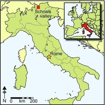
Following his discovery in 1991, the most widely accepted explanation for the presence of the Iceman in such a high-altitude mountain setting as the upper Ötz Valley is that he was involved in seasonal vertical transhumance (Spindler Reference Spindler, Wilfing, Rastbichler-Zissernig, zur Nedden and Nothdurfter1996, Reference Salzani2005; Egg & Spindler Reference Egg and Spindler2009). This educated guess was substantiated by pollen analysis of peat deposits in the vicinity of the discovery site (Bortenschlager Reference Bortenschlager, Bortenschlager and Oeggl2000), and by a traditional transhumance route (Figure 1) that runs near to the site of the body's discovery. Since medieval times, farmers from the Vinschgau and Schnals Valleys have driven their sheep along this livestock trail into the high mountains to pasture on the Alpine grasslands. The practice is attested by a document of AD 1416 that guaranteed grazing rights in the pastures in the upper Ötz Valley to farmers from the Schnals Valley (Hye Reference Hye1967–Reference Hye1968; Werner Reference Werner1969). Only archaeological survey and palynological analyses can show whether Chalcolithic people also moved with their livestock up to the high Alpine pastures.
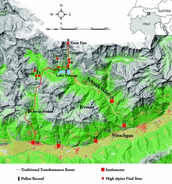
Figure 1. Traditional transhumance route through the Schnals Valley (map source: geodetic survey of the province of Bolzano).
Study area: the Lagaun, Finail and Tisen Valleys
The Schnals Valley is the largest valley branching off the Vinschgau Valley (South Tyrol, Italy); it leads towards the north-west and is characterised by steep slopes, which were shaped first by glacial then by fluvial activity. The tributary valleys of the Schnals Valley—the Lagaun, the Finail and the Tisen Valleys (Figure 1)—have a V-shaped section as a result of fluvial erosion. The Lagaun Valley branches off to the west and connects the upper Vinschgau Valley with the area of the current investigation. The Finail and Tisen Valleys turn to the north and terminate at the main Alpine ridge. The altitude of these valleys ranges between 1990 and 3600m asl. All three lie along the traditional transhumance route, and are still used today by local farmers for grazing.
The Lagaun Valley
Archaeological surveys in the Lagaun Valley have revealed new Mesolithic sites at an altitude of 2370m asl (Figure 1.1) that are associated with hunting activities, as well as the remains of a much later, stone-built Alpine hut (Figure 1.2). Lead shot from a charcoal layer dates this structure between the fifteenth and eighteenth centuries AD. Close by (2188m asl), a carbon layer including burnt animal bones was dated to the Late Iron Age or Roman period (60 BC–AD 140 cal (95.4% probability)) (Figure 1.3).
The Finail Valley
The sanctuary site of Untere Grube in the Finail Valley was excavated in July 2010 (Figure 1.4). Parts of the prehistoric structures are still visible today above ground level (Figure 2) and consist of a circular layer of flagstones covering a 200mm-thick charcoal layer. This layer contained ceramics, burnt bones and, surprisingly, amber and glass beads. They were probably the remains of burnt offerings. The charcoal layer overlay four offering pits (Figure 3). Offering pit 2 (Figure 4) was radiocarbon dated to 1310–980 cal BC (95.4% probability) and pit 4 to 1320–1020 cal BC (95.4% probability). Close to the offering pits was a rectangular hearth (Figure 5) built of small stones embedded in a layer of vitrified clay. Associated finds consisted of local Late Bronze Age pottery dating to 1350–1060 BC (Figure 6.1–6.5). A fragment of loom weight (Figure 6.11) was an exceptional discovery and is interpreted as a votive offering given in thanks for a successful grazing season. It suggests that this building was a sanctuary frequented by shepherds. The loom weight also documents the long tradition among Schnals farmers of a pastoralist economy based on secondary products (Werner Reference Werner1969). Especially remarkable for such a high Alpine site is the discovery of 40 amber and glass beads (Figure 7). The amber (succinic) for the beads came from the Baltic region (Stahl Reference Stahl2006), and their form—a conical body and horizontal perforation (Figure 7.25–7.27)—is so far known only from the Late Bronze Age cemeteries of Neftenbach II and Reinach (Beck & Heider Reference Beck, Heider, Fischer and Kaufmann1994; Fischer Reference Fischer1997). In the cemetery of Olmo di Nogara (province of Verona, northern Italy) amber beads are very rare and were recovered exclusively from female tombs of high social status (Salzani Reference Salzani2005). The glass beads (Figure 7.36–7.41) found at the Finail site resemble those from the Terramare settlements of northern Italy (Bellintani & Residori Reference Bellintani and Residori2003) dated mainly to HA A1 (1200–1130 BC). Comparisons can be found at the settlement of Fratta di Polesine in the province of Rovigo, where local glass production is documented (Bellintani & Stefan Reference Bellintani and Stefan2009).

Figure 2. The findspot ‘Untere Grube’ in the Finail Valley (photograph: Andreas Putzer).
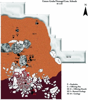
Figure 3. The position of the offering pits and the hearth (graphics: Andreas Putzer).

Figure 4. Offering pit 2 (photograph: Andreas Putzer).
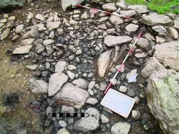
Figure 5. The sacrificial hearth (photograph: Andreas Putzer).
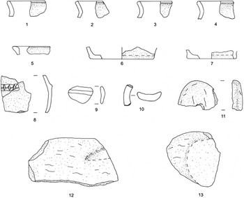
Figure 6. The finds from ‘Untere Grube’: 1–10) ceramic; 11–13) stone; scale 1:2 (graphics: Andreas Putzer).
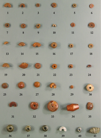
Figure 7. The amber and glass beads from ‘Untere Grube’: 1–35) amber; 36–41) glass; scale 1:2 (graphics: Andreas Putzer).
The Tisen Valley
In 2011 the focus of fieldwork was the Tisen Valley, which was surveyed in its entirety from the Iceman's findspot down to the valley entrance. Several Mesolithic sites have been uncovered, one of them with a radiocarbon date of 6690– 6490 cal BC (95.4% probability) (Figure 1.6). Flint flakes and blade fragments associated with a charcoal layer also document the use of the valley for hunting during the Neolithic period, around 4050–3900 cal BC (95.4% probability) (Figure 1.7). More significant was the site discovered at Jochwiese at the valley entrance, at 2020m asl (Figures 1.9 & 8). The first trial trench revealed a layer of rubble including burnt stones, calcined bones and a bronze dagger with a trapezoidal blade (Figure 9.11) dated to an early phase of the Middle Bronze Age (c. 1550–1480 BC) (Urban Reference Urban1993). North of the rubble layer was an offering pit dated to the Late Bronze Age (1200–1100 BC) through the presence of local ‘Laugen’ ceramics (Figure 9.3 & 9.6). The offering pit was cut through another pit with a diameter of about 2m, dated to the Middle Bronze Age according to the stratigraphy and the remains of two handles of ‘ansa cornuta’ (Figure 9.7–9.8) type—a common potteries feature of the Middle Bronze Age in Northern Italy (Urban Reference Urban1993). The archaeological features recall those of local high alpine places for burnt offerings, suggesting that this too was a sanctuary.
Figure 8. The find spot ‘Jochwiese’ in the Tisen Valley (photograph: Andreas Putzer).
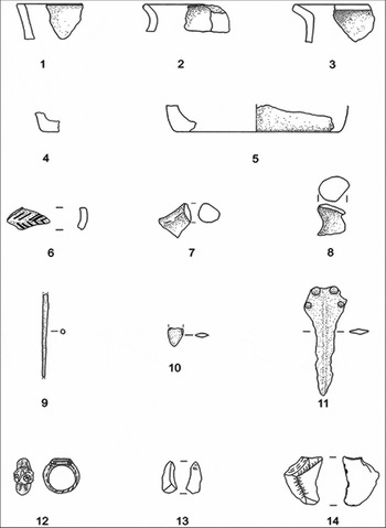
Figure 9. The finds from ‘Jochwiese’: 1–8) ceramics; 9–11) bronze; 12) pewter; 13–14) flint; scale 1:2 (graphics: Andreas Putzer).
Discussion and interpretation
The sites in the Lagaun Valley gave no evidence for use of the valley as a transhumance route during the Chalcolithic. Only the site close to the Alpine hut might have been associated with pastoralist activity, and here the evidence suggests a structure of Late Iron Age date. The sanctuaries of the Tisen and Finail Valleys must be seen in their chronological context. The linear distance between the cult places is about 3.5km. At Untere Grube, the hearth used for votive offerings and the adjacent offering pits played a major role. The discovery of a whetstone and a grindstone (Figure 6.12 & 6.13) close to the offering pits suggests that they were used for the preparation of a sacrificial feast. Haupt (Reference Haupt2010) provides prima facie evidence from experiments and ethnological comparisons to show that the pits had a cooking function.
A novel feature of the Finail Valley sanctuary is the demarcation of the centre of the offering place by a circle of standing monoliths and the presence of a cup-marked stone close to the offering hearth. According to Steiner (Reference Steiner2010), cup-marked stones occur only exceptionally in such contexts. The presence of amber beads among burnt offerings is unexpected, as they are highly flammable, but they do reveal connections with other Central European cultural groups. The glass beads were imported from the Terramare settlements of northern Italy, whereas the amber beads probably came via Switzerland, and document the importance of the Vinschgau and, possibly, the Finail Valleys for interregional trade.
The series of archaeological sites dated to the Bronze Age in the Schnals Valley and its tributaries suggests a seasonal presence connected to pastoralism during this period but no earlier. It is difficult, however, to determine from which starting locations people travelled to the tributary valleys. Finds from Katharinaberg indicate the existence of a settlement in the lower reaches of the valley (Figure 1.10; Bagolini et al. Reference Bagolini, Dal Rì, Lippert, Nothdurfter, Spindler, Rastbichler-Zissernig, Wilfing, Nedden and Nothdurfter1995). There are Bronze Age settlements in the main Vinschgau Valley, from which it is possible to reach the Schnals Valley within a day's walk, including Juval (Figure 1.11), Kastelbell (Figure 1.12), Goldrain (Figure 1.13) and Kortsch (Figure 1.14).
Palynological analyses
The aim of the palynological study was to explore whether the Iceman was involved in transhumance by reconstructing the onset and development of alpine pasture in the Vinschgau area. Information on the method used is given in the online supplementary material to this article. Pollen analyses were conducted at three mires and one lake aligned along the traditional Vinschgau Valley transhumance route (Figure 1): Lake Vernagt in the Schnals Valley at 1610m asl; the Schwarzboden mire in the Maneid Valley at 2150m asl; the Lagaun mire (2180m asl); and the Penaud mire (2330m asl). The sediment and peat deposits of the Tisen and Finail Valleys were more recent than the Copper Age and thus not relevant to our enquiry. From each site, a peat or sediment core was collected. Chemical digestion followed standard procedures for fossil-pollen analyses (Faegri & Iversen Reference Faegri and Iversen1989), accompanied by AMS dating and loss-on-ignition analyses (Festi et al. Reference Festi, Putzer and Oeggl2014). The pollen analysis of Lake Vernagt (Figure 10) enabled the vegetation and environment at the entrance of the Finail and Tisen Valleys to be reconstructed, along with land-use changes around the lake. In addition, the palynological results from the three higher altitude mires provided the basis for the reconstruction of pastoralist activity above the timber line (Figure 11).

Figure 10. Lake Vernagt, simplified pollen diagram: percentage values of main pollen types and micro-charcoal particles are shown with exaggeration curves (×10); pollen sum includes AP (arboreal pollen) and NAP (non-arboreal pollen). In the main pollen diagram: dark green indicates AP; yellow corresponds to Gramineae; and light green with yellow areas indicates the proportion of NAP; black line with dots (-●-) represents Pinus; white line with triangles (-▲-) represents Picea.
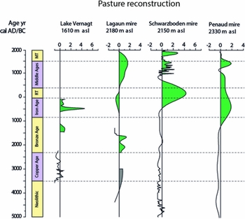
Figure 11. Reconstruction of pastures in the investigated high valleys (Festi et al. 2014, modified): positive values correspond to potential occurrence of grazing activity; green areas represent true pasture phases; grey areas represent rejected pasture phases (see text); abbreviation: RT = Roman time; MT = modern time.
Results: human impact and grazing activity in the study area
The lowermost site, Lake Vernagt, is located at the entrance of the Finail and Tisen Valleys (Figure 1), and is hence an ideal archive from which to reconstruct human activity in the two valleys. Figure 10 presents a simplified pollen diagram for this lake (for more details see Festi et al. Reference Festi, Putzer and Oeggl2014).
The sediment deposit encompasses the time span from about 3600–100 BC, including the whole of the Copper Age as well as the Bronze and Iron Ages. During the Copper Age, the lake was surrounded by a Pinus (pine) and Picea (spruce) forest intermingled with larch (Larix decidua): two phases of Picea preponderance are recorded at 3600–3350 and 2600–2400 cal BC, intercalated by a Pinus-dominated period occurring at 3350–2600 cal BC. During the latter phase, Alnus (alder) expanded around the lake, suggesting wetter climatic conditions. Pasture reconstruction shows a low probability of grazing activity (Figure 11): the slight increase in pasture indicators (mainly Artemisia and Chichorioideae) is not supported by any other indication of human impact and was probably caused by the rise in precipitation that characterised the Rotmoos/Piora II cold climatic fluctuation (3500–3050 cal BC; Hormes et al. Reference Hormes, Müller and Schlüchter2001; Magny Reference Magny2004). Hence, during the Copper Age, there is no palynological and archaeological indication of human settlement or of seasonal activities such as alpine farming, although occasional human activity around the lake, such as hunting, cannot be excluded. The Schwarzboden, Lagaun and Penaud mires reveal a very similar situation at higher altitudes, where no human impact could so far be observed in either the palynological and archaeological evidence. Pasture reconstruction (Figure 11) shows no indication of pastoral activity around the Penaud and Schwarzboden mires. The Lagaun mire presents positive values but must be rejected because it is based on an increase of a single pollen type (Campanula-type) and is not supported by other palaeoecological or archaeological evidence. The only evidence of human interest in the high mountains of the Vinschagau Valley during the Copper Age is the Iceman mummy (3370–3100 BC). Indeed, the fact that the Iceman walked through the Schnals and Tisen Valleys on his way up to the Similaun glacier (Oeggl et al. Reference Oeggl, Kofler, Schmidl, Dickson, Egarter-Vigl and Gaber2007) suggests that the high altitudes of the Vinschgau Valley were frequented by humans during the Copper Age.
The first signs of settlement activity near Lake Vernagt appear in the late Bronze Age, at 1350–1150 cal BC, with the decline of both climax trees—Pinus and Picea—and the expansion of Gramineae (true grasses), combined with an increase in pasture indicators. Altogether this suggests an opening up of the forest for grazing purposes. Furthermore, the expansion of Larix during this period was probably favoured for grazing activity. Larix is still today the main tree around the lake, forming pure larch stands characterised by plenty of grass in the understorey. This peculiar type of vegetation is locally known as ‘Lärchenwiese’ (larch meadows). According to the Vernagt pollen diagram, Lärchenwiese developed around Lake Vernagt during the Bronze Age, at about 1400 cal BC. The palynological signal indicating the onset of local pasture at that time (Figure 11) is also confirmed by the contemporary archaeological sites of the Finail and Tisen Valleys. More generally, it is evident that the first development of alpine pastures in the Vinschgau Valley can be dated, at the earliest, to the beginning of the Bronze Age, as is shown by the pasture reconstruction for the Lagaun Valley (Figure 11).
Additional evidence of the human impact on the vegetation near the lake is present during the Iron Age, in the period 550–150 cal BC. At this time, local forests were cleared, as is reflected by the decline of Picea and Pinus pollen, an increase in micro-charcoal and a rise in Gramineae and herbal taxa, including pasture indicators. On that note, the first cereal pollen grains are recorded then too, indicating the possible presence of cereal fields close to Lake Vernagt. This interpretation of the palynological evidence has been confirmed by the recent discovery of an Iron Age site (Figures 1 & 5) close to the lake dated to 360–160 cal BC (95.4% probability). Moreover, the Penaud and Schwarzboden mires indicate increased human impact with the development of alpine pasture (Figure 11), confirming that in this period human activities extended up to higher altitudes.
Was the Iceman involved in pastoral economy?
No archaeological or palynological evidence supports the occurrence of pastoral economy in the Schnals Valley during the Chalcolithic (3500–2200 BC). It therefore does not seem reasonable to suppose that the Iceman travelled to a high altitude in a transhumance context. Further arguments contradict the common notion that Ötzi moved with his flock to such inhospitable altitudes. During the Chalcolithic, flocks consisted typically of sheep or goats (Ebersbach Reference Ebersbach2002; Festi et al. Reference Festi, Tecchiati, Steiner and Oeggl2011). Results from an alpine burnt offering site in the Maneid Valley (Mahlknecht Reference Mahlknecht and Mandl2006) suggest that during the Bronze Age, herders chose to drive up sheep and goats because of their distinct demand on nutriment. Sheep prefer grasses with high nutritional value that grow mostly on a stony substrate. Goats need tannins in addition to grass, and they obtain them mostly from browsing on tree shoots. It would thus have been impractical for the Iceman, as a herder, to move up to the Tisen Pass at about 3200m asl, where there was no valuable supply of nutriment for his livestock. The hypothesis that he had to cross the main Alpine ridge, following the current transhumance route, to reach the Ötz valley in order to access grazing territory so as to feed his flock seems equally implausible. In fact, during the Chalcolithic, the grassmats characterising the higher altitudes of the Vinschgau (e.g. the Schnals Valley and its tributary valleys) offered sufficient nutriment for the flocks. This becomes even more evident if we consider the low demographic pressure in the region during that time (Steiner Reference Steiner2007). Furthermore, the Tisen Valley, of all the tributary valleys of the Schnals Valley, is the least suitable for pastoralism, as it is frequently subject to gravitational events (i.e. rock falls) activated by heavy rainfall. This is supported by the several historic and modern landslides that characterise the valley landscape. Finally, there seem to be no factors that could have triggered the onset of transhumance during the Iceman's lifetime and forced humans to risk crossing the main Alpine ridge with their flocks in order to find grazing areas. Transhumance is in fact a highly risky investment, as it implies a loss of time, labour, animal health and possibly the animals themselves. If a farmer must move livestock for feeding, it would be best to move as close as possible to the home village to minimise the risks. The absence of Chalcolithic caprine dung from the site where the Iceman was discovered (Oeggl et al. Reference Oeggl, Schmidl and Kofler2009) again emphasises the lack of evidence pointing to transhumance and pastoralism during his lifetime.
To test the hypothesis of a trans-Alpine transhumance, the situation north of the Alpine ridge, in the Austrian valley of Ötz, must also be taken into consideration. No archaeological traces of Chalcolithic human presence have been recovered from the Ötz Valley, nor later from the Bronze and Iron Ages. This could merely reflect a lack of research, but linguistic evidence suggests otherwise. In the uppermost section of the Ötz Valley—which was populated from the South (Loose Reference Loose and Loose1993)—only Romanic toponyms occur (Anreiter et al. Reference Anreiter, Chapman and Rampl2009), in contrast to the Schnals Valley where there were different toponyms derived from Etruscan script (Kollmann Reference Kollmann2007). This linguistic divergence indicates that the use of the medieval transhumance route from the Chalcolithic period is unlikely, especially given the reasons that triggered the opening of this trail during the Middle Ages. The need to expand the grazing territory of the Schnals Valley arose when the communities of the upper Vinschgau Valley entrusted the farmers there with the care of their livestock during the summer (Loose Reference Loose1976), thereby forcing them to widen their territory to include the Ötz Valley.
If the Iceman was not involved in transhumance, why was he familiar with such high altitudes?
The Iceman's equipment is similar to that recovered from the graves of warriors or hunters of the Remedello di Sotto cemetery close to Brescia in northern Italy (Egg & Spindler Reference Egg and Spindler2009). It consists partly of elements taken from wild animals, and his diet was based mainly on game (Rollo et al. Reference Rollo, Ubaldi and Ermini2002) i.e. ibex (Capra ibex) and deer (Cervus elaphus), linking him to hunting. Osteological analysis of the mummy showed arthrosis of the right shoulder and left wrist (Gostner et al. Reference Gostner, Egarter-Vigl and Reinstadler2004, Reference Gostner, Pernter, Bonatti, Graefen and Zink2011) resulting from overstressing of body parts by the drawing of a bow (Villotte Reference Villotte2009; Thomas Reference Thomas2014).
Ibex and chamois still inhabit the area around the Tisen Pass today during summer. The Iceman was not the first to use the area for hunting. Finds from the body's findspot (Bagolini et al. Reference Bagolini, Dal Rì, Lippert, Nothdurfter, Spindler, Rastbichler-Zissernig, Wilfing, Nedden and Nothdurfter1995; Dal Rì Reference Dal Rì and Samadelli2006; Egg & Spindler Reference Egg and Spindler2009) show that Mesolithic hunters also frequented the site. The Tisen Pass is not the only location where Chalcolithic finds are present alongside those left by Mesolithic hunters (Bagolini & Pedrotti Reference Bagolini, Pedrotti, Höpfel, Platzer and Spindler1992; Della Casa Reference Della Casa2002). The archaeological finds consist mainly of flint arrowheads, which could be connected to a revival of hunting during the Chalcolithic. This is reflected in Chalcolithic settlements, where an increase in wild animal bones—for example, at Tolerait in the Etsch Valley (northern Italy) (Dal Rì Reference Dal Rì and Samadelli2006) and Isera la Toretta in the Trentino province (northern Italy) (Riedel & Rizzi Reference Riedel and Rizzi1997; Tecchiati et al. Reference Tecchiati, Castiglioni, Rottoli and De Marinis2013)—shows that hunting became once again an important source of food. This resurgence in hunting could have been a consequence of climatic change: a cold climate spell may well have reduced agricultural yields, forcing the population to compensate for the loss of calories in the diet with meat derived from hunting activity. The period in which the Iceman lived (3370–3100 BC; Kutschera et al. Reference Kutschera, Patzelt, Wild, Haas-Jettmar, Kofler, Lippert, Oeggl, Pak, Priller, Steier, Wahlmüller-Oeggl and Zanesco2014) was indeed characterised by climate change. In particular, moist and cold climate conditions between 3300 and 3200 BC (Haas et al. Reference Haas, Richoz, Tinner and Wick1998; Magny Reference Magny2004; Nicolussi Reference Nicolussi, Oeggl and Prast2010) also caused a decline of the tree line (Nicolussi et al. Reference Nicolussi, Kaufmann, Patzelt, van der Plicht and Thurner2005). A similar dietary response to climatic change is postulated for the Alpine foreland during the thirty-seventh century BC, as shown by palaeoeconomic and climate data from settlements close to Lake Zürich (Schibler Reference Schibler, Schibler, Hüster-Plogmann, Jacomet, Brombacher, Gross-Klee and Rast-Eicher1997, Reference Schibler2006). The impact of such climatic events is documented by written sources of the late Middle Ages and the early Modern period during the so-called ‘Little Ice Age’ (Irniger Reference Irniger1991), when the climate was characterised by cool springs and autumns, with crop failures being the frequent result. Loss of the most important source of calories—cereals—induced communities to compensate by hunting wild animals and collecting plants with high fat content (Schibler Reference Schibler, Schibler, Hüster-Plogmann, Jacomet, Brombacher, Gross-Klee and Rast-Eicher1997; Della Casa Reference Della Casa2002).
To conclude, our results do not support the common theory that the Iceman moved to the high altitude region where his body was found in the course of pastoral activity.
Acknowledgements
These results are the fruits of the following research projects: ‘The Neolithic Agricultural Regime in the Inner Alps’, financed by the Austrian Science Fund (grant: P21129-G19), and the project ‘Prähistorische Besiedlung und Ökonomie inneralpiner Hochtäler im Falle des Schnalstals (Südtirol/Italien)’, financed by the South Tyrolean Science Fund FWF (grant: B35E12000330003). The research is a collaborative enterprise between the Institute of Botany of the University Innsbruck, the Department of Ground Monuments of Bolzano and the South Tyrol Museum of Archaeology.
Supplementary material
To view supplementary material for this article, please visit http://dx.doi.org/10.15184/aqy.2015.185


