1. Introduction
The possibility that dolomite can precipitate in active surface sedimentary systems, such as soils, has long been in dispute. Dolomite is commonly associated with diagenesis in sedimentary rocks (Leeder, Reference Leeder1999), and some laboratory experiments have shown that it is impossible to directly precipitate dolomite from solution at atmospheric temperatures and pressures (Sherman & Barak, Reference Sherman and Barak2000). Others have shown that precipitation of dolomite from solution at atmospheric temperatures and pressures can occur in the presence of certain bacteria (Roberts et al. Reference Roberts, Bennett, Gonzalez, Macpherson and Milliken2004; Wright & Wacey, Reference Wright and Wacey2005; Sánchez-Román et al. Reference Sánchez-Román, Vasconcelos, Schmid, Dittrich, McKenzie, Zenobi and Rivadeneyra2008). In addition, it has been postulated that under highly evaporative conditions, magnesium will inhibit calcite nucleation, and allow dolomite to form (Watts, Reference Watts1980).
Dolomite has been observed in some modern soils in arid desert settings (Bui, Loeppert & Wilding, Reference Bui, Loeppert and Wilding1990; Retallack & Mindzenty, Reference Retallack and Mindszenty1994; Kohut, Muehlenbacks & Dudas, Reference Kohut, Muehlenbacks and Dudas1995; Capo et al. Reference Capo, Whipkey, Blachère and Chadwick2000) and in a few fossil soils (e.g. Kessler, Soreghan & Wacker, Reference Kessler, Soreghan and Wacker2001; Capo et al. Reference Capo, Whipkey, Blachère and Chadwick2000; Bustillo &Alonso-Zarza, Reference Bustillo and Alonso-Zarza2007). In fossil soils (palaeosols), the dolomite is thought to be related to high chemical activity of aqueous fluids, and rapid evapotranspiration of soil water (Sheldon & Tabor, Reference Sheldon and Tabor2009). Dolomitic palaeosols are thus considered to be rare in the geological record (Sheldon & Tabor, Reference Sheldon and Tabor2009).
In this study, we report the first evidence of dolomite in palaeosols of latest Permian age, just prior to the Permian–Triassic (P–Tr) boundary. The Late Permian period was an important time in Earth history, marked by extreme climate change and biotic crisis (e.g. Kidder & Worsley, 2005; Erwin, 2008), with evidence of increased seasonality, at least in the southern hemisphere (Tabor et al. Reference Tabor, Montanez, Steiner and Schwindt2007; Gastaldo & Rolerson, Reference Gastaldo and Rolerson2008; Pace, Gastaldo & Neveling, Reference Pace, Gastaldo and Neveling2009; Kearsey et al. Reference Kearsey, Twitchett, Price and Grimes2009). Palaeosol nodules with an unusual mineralogy have been recorded at, or very close to, the latest Permian mass extinction horizon in Antarctica, reflecting the specific atmospheric and climatic conditions associated with the biotic crisis (Sheldon & Retallack, Reference Sheldon and Retallack2002). Palaeosol morphology and composition vary across the Permian–Triassic boundary, which may be a response to changes in climate and atmosphere (Retallack & Krull, Reference Retallack and Krull1999; Krull & Retallack, Reference Krull and Retallack2000; Macleod et al. Reference MacLeod, Smith, Koch and Ward2000; Ward et al. Reference Ward, Botha, Buick, De Kock, Erwin, Garrison, Kirschvink and Smith2005; Arche & López-Gómez, Reference Arche and López-Gómez2005; Tabor et al. Reference Tabor, Montanez, Steiner and Schwindt2007; de la Horra et al. Reference de la Horra, Benito, López-Gómez, Arche, Barrenechea and Luque2008; Gastaldo & Rolerson, Reference Gastaldo and Rolerson2008).
Herein, the mineralogy, textures and geochemistry of well-preserved and well-dated palaeosol nodules from the Upper Permian (Changhsingian Stage) and Lower Triassic (Induan and Olenekian stages) of the South Urals, Russia, are described for the first time in order to determine the distribution, origin and significance of the palaeosol-hosted dolomite. The origin and distribution of this dolomite sheds new light on environmental change through this important interval in Earth history.
2. Geological setting
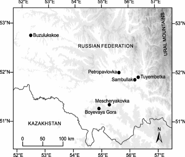
P–Tr palaeosols were examined at six locations in the Orenburg region of the South Urals, Russia (Fig. 1). Here, Upper Permian and Lower Triassic strata form the continental fill of the southern Uralian Foredeep and extend onto adjacent parts of the Russian Platform and North Caspian Basin (Newell, Tverdokhlebov & Benton, Reference Newell, Tverdokhlebov and Benton1999; Tverdokhlebov et al. Reference Tverdokhlebov, Tverdokhlebova, Surkov and Benton2002). The Late Permian depositional setting was dominated by muddy fluvial overbank deposits with minor channel sandstones, while the Early Triassic period is marked by an abrupt influx of coarse fluvial conglomerates and sandstones. This abrupt change in sedimentary facies across the P–Tr boundary is thought to be related to reductions in vegetation cover in the drainage basin caused by the mass extinction event (Newell, Tverdokhlebov & Benton, Reference Newell, Tverdokhlebov and Benton1999). Distal from the Ural Mountain Belt, which formed the primary source of sediment, fluvial deposits are interbedded with aeolian sandstones (for extended palaeogeographic discussion see Newell, Tverdokhlebov & Benton, Reference Newell, Tverdokhlebov and Benton1999; Tverdokhlebov et al. Reference Tverdokhlebov, Tverdokhlebova, Surkov and Benton2002, Reference Tverdokhlebov, Tverdokhlebova, Minikh, Surkov and Benton2005). During Late Permian and Early Triassic time, the studied sections were at an estimated palaeolatitude of 30–35° N (Van der Voo & Torsvik, Reference Van der Voo, Torsvik, Channel, Kent, Lowrie and Meert2004; Taylor et al. Reference Taylor, Tucker, Twitchett, Kearsey, Benton, Newell, Surkov and Tverdokhlebov2009).

Figure 1. Map of the Orenburg region, South Urals, Russia, close to the border with Kazakhstan. The sections at Buzulukskoe, Boyevaya Gora, Mescheryakovka, Petropavlovka, Sambullak and Tuyembetka are marked.
The continental succession is dated primarily using biostratigraphy (ostracods and vertebrates) and magnetostratigraphy (Tverdokhlebov et al. Reference Tverdokhlebov, Tverdokhlebova, Minikh, Surkov and Benton2005; Taylor et al. Reference Taylor, Tucker, Twitchett, Kearsey, Benton, Newell, Surkov and Tverdokhlebov2009; Fig. 2). Three sections, Sambullak (51.87993° N, 56.21167° E), Tuyembetka (51.92196° N, 56.32694° E) and Boyevaya Gora (51.29805° N, 54.90949° E), contain palaeosols of latest Permian age (Fig. 2). Boyevaya Gora is the only section that contains palaeosols of both earliest Triassic (Induan) and latest Permian (Changhsingian) age. Based on biostratigraphical evidence, sections from Petropavlovka (52.03289° N, 55.63512° E), Mescheryakovka (51.37925° N, 55.28140° E) and Buzulukskoe (52.79650° N, 52.32582° E) contain palaeosols of Early Triassic age (Fig. 2; Tverdokhlebov et al. Reference Tverdokhlebov, Tverdokhlebova, Surkov and Benton2002).
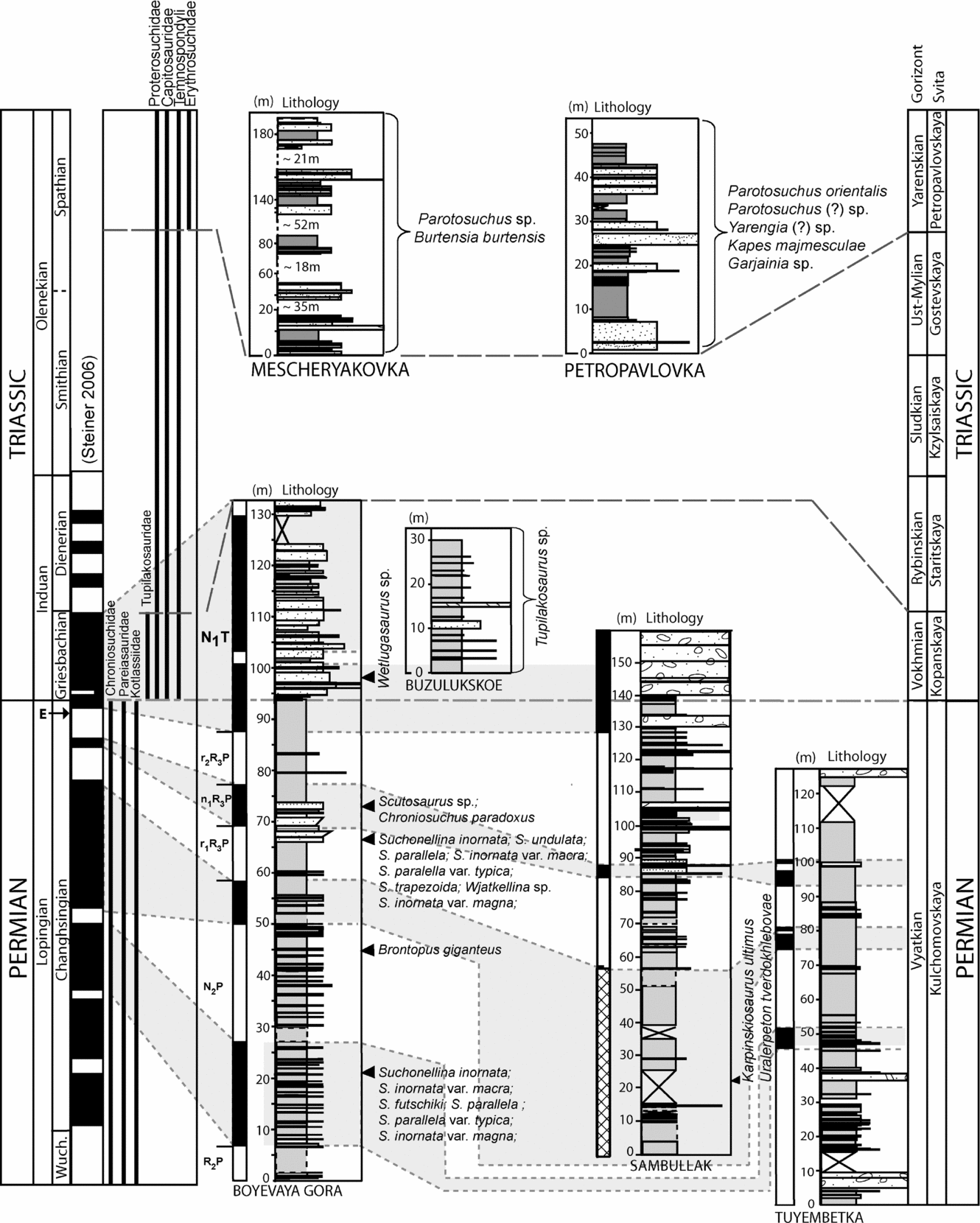
Figure 2. Biostratigraphic and magnetostratigraphic correlations of the sections in this study. Biostratigraphic control for the sections was compiled from Surkov et al. (Reference Surkov, Benton, Twitchett, Tverdokhlebov and Newell2007) and Tverdokhlebov et al. (Reference Tverdokhlebov, Tverdokhlebova, Surkov and Benton2002, Reference Tverdokhlebov, Tverdokhlebova, Minikh, Surkov and Benton2005) with correlation to the global timescale based on Benton, Tverdokhlebov & Surkov (Reference Benton, Tverdokhlebov and Surkov2004). Palaeomagnetic data and correlations are based on Taylor et al. (Reference Taylor, Tucker, Twitchett, Kearsey, Benton, Newell, Surkov and Tverdokhlebov2009) (including the names of the palaeomagnetic zones) and correlated to Steiner's (Reference Steiner, Lucas, Cassinis and Schneider2006) global stratigraphy. The stratigraphy in the left column is the international stratigraphy; right column is the local Russian stratigraphy. Arrowed E indicates position of mass extinction horizon, from the global composite magnetostratigraphic correlation of Hounslow et al. (Reference Hounslow, Peters, Mørk, Weitschat and Os Vigran2008).
3. Palaeosols: general characteristics and classification
In total 156 palaeosols were identified in the six locations, which provided a total of 580 m of logged section (Table 1). Palaeosol profiles range from 0.15 to 1.64 m thick and were identified primarily on the basis of the presence of rooting, colour mottling, angular blocky ped structure, the lack of stratification and presence of carbonate nodules. All of the palaeosols developed from fine-grained, muddy (clay and silt) or very fine sand parent material, which contained a variable proportion of sand. There are distinct differences between Permian and Triassic palaeosols.
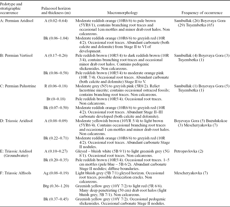
Table 1. Features of the different pedotypes identified in the South Urals of Russia and their frequency of occurrence in the sections studied
3.a. Permian palaeosols
The Upper Permian palaeosols can be divided into separate sub-horizons (after the method of Retallack, Reference Retallack2001) (Table 1). The A horizon (defined as being the surface horizon of a soil; Retallack, Reference Retallack2001) of these palaeosols is typically 10R in colour (using the Munsell colour system), and are between 0.02 and 0.64 m thick. They are identified as an A horizon based on the presence of root traces (cf. Retallack, Reference Retallack1993). These root traces take the form of reddened clay infills, which are formed by the oxidation of the original organic matter of the root (cf. Retallack, Reference Retallack2001), and are 2–6 mm in width and 20–50 mm long with an obvious tapering and branching structure. The palaeosols also all contain a developed Bk horizon, which is between 0.06 m and 1.04 m thick, and represents an accumulation of carbonate (calcrete) within the lower part of the soil profile. Applying the soil carbonate classification scheme of Machette (Reference Machette and Weide1985), the calcrete ranges in maturity from Stage II nodules, through Stage III and IV coalesced nodules, to Stage V indurated calcrete horizons. The Stage II nodules are hard, indurated spherical or sub-spherical nodules generally less than 5 cm in diameter. The nodules have sharp boundaries and are found either in discrete 2–40 cm horizons or dispersed over 50–104 cm. In some cases root traces are preserved as drab root haloes (Fig. 3). The Stage III horizons are formed of nodules which increase in size up to 20 cm and have merged and welded laterally into a discontinuous nodular bed. The Stage IV horizons are defined by the occurrence of a laminated, solid calcrete top which is 8–16 cm thick. These Stage IV carbonates have been found to contain ostracod fossils (Fig. 4). They are also related to channel fills which have become calcified palaeosols after the deposition of the channel fill. The Bk horizon of the Stage V calcrete units predominantly consists of massive micritic carbonate, which is cut by many iron-stained root traces. The top 5 cm of the carbonate layer show minor brecciation with pisoliths of carbonate (Fig. 3, Palaeosol Type B).
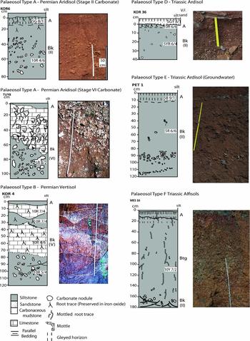
Figure 3. Sedimentary logs and photographs of a Palaeosol Type A (Permian Aridisol) with a Stage II carbonate horizon and Palaeosol Type A (Permian Aridisol) with a Stage VI carbonate horizon (from Tuyembetka). Also Palaeosol Type B (Permian Vertisol) and Palaeosol Type D (Triassic Aridisol), note the change in colour and thickness with respect to Type A palaeosols, and Palaeosol Type E (Triassic Aridisol Groundwater) and Palaeosol Type F (Triassic Alfisol). Note that Palaeosol Type C can be seen in Figure 4. For full descriptions of the sub-horizons within the palaeosols see Table 1.
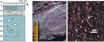
Figure 4. A Palaeosol Type C lacustrine-associated palaeosol showing lacustrine carbonate at the top (marked A). (a) shows the carbonate top (A) which is composed of micritic mud with 1 mm wide curvilinear laminations; (b) is a petrographic thin-section of (a) showing ostracod (arrowed) from lacustrine top, which has been stained with a calcite-specific stain.
Above this, the Stage V calcrete units form lenses of reddened clay within the carbonate layers, which are 16 cm long and 8 cm high and pinch in and out through the bed.
Supermature carbonate beds with brecciated tops (Stage VI) were observed only at Tuyembetka (Fig. 3, Palaeosol Type A, Permian Aridisol Stage VI carbonate). They average 0.43 m thick but range up to 1.20 m thick, and they also contain thin, highly deformed, often vertically-orientated, sinuous lenses and patches of the host mudstone. The lower half of each limestone bed is commonly laminated or bedded on a scale of 1–5 cm. Bedding is generally irregular, discontinuous and wavy. In contrast, the upper half of each limestone bed is commonly a massive, well-cemented breccia composed of centimetre-scale angular clasts set in a matrix of micrite or microspar. Overall, however, these carbonate beds are uncommon, and 46% of the palaeosol profiles show only the development of isolated Stage II nodules (ranging in diameter from 20–50 mm).
The Upper Permian palaeosols can be divided into three distinct pedotypes: A, B and C (Fig. 3; Table 1). Palaeosol Type A is distinct by only containing A and B horizons, having branching root traces and abundant carbonate development (Fig. 3, Palaeosol Type A, Table 1). The uncompressed depth between the Bk horizon and the palaeosurface is less than 1 m, indicating that these palaeosols may be classified as Aridisols (after Soil Survey Staff, 1999). Palaeosol Type B also contains both an A and B horizon. The A horizon contains branching root traces while the Bk horizon contains abundant carbonate development and is distinct by containing pedogenic slickensides (Fig. 3, Palaeosol Type B, Table 1). The presence of pedogenic slickensides in some of the palaeosols indicates that Vertisols were also present (after Soil Survey Staff, 1999). Seven palaeosols in the Permian were identified as Palaeosol Type C. These have a capping limestone horizon of between 0.06 m and 0.18 m thick, which is composed of micritic mud with 1 mm wide curvilinear laminations. This horizon also contains ostracod fossils (Fig. 4). These were interpreted to be palustrine palaeosols (cf. Newell, Tverdokhlebov & Benton, Reference Newell, Tverdokhlebov and Benton1999), and probably formed from the drying out of small lakes or ponds (Palaeosol Type C, Table 1). In the context of this study, and given that it is impossible to determine the moisture regimes of ancient soils, the term ‘Aridisol’ purely denotes the presence of a Bk horizon less than 1 m from the palaeo-land surface. Using the scheme devised by Mack, James & Monger (Reference Mack, James and Monger1993), all the palaeosols in the South Urals would be classified as Calcisols.
3.b. Triassic palaeosols
The palaeosols of the Triassic are in general a browner colour than those in the Permian (5YR to 10Y compared with 10R, see Fig. 3, Table 1). In common with the Permian palaeosols, they also contain root traces, but these are often associated with gleyed A and Btg horizons (Palaeosols Type E and F, Table 1). They contain carbonate nodules, but these are not developed above Stage II. The Triassic palaeosols can also be divided into three distinct pedotypes. Palaeosol Type D is on average thinner and thus less well developed than the Permian palaeosols (Fig. 3, Palaeosol Type D, Table 1). They contain horizons of indurated spherical or sub-spherical nodules generally less than 2 cm in diameter, which are found in discrete 22–71 cm horizons (Fig. 3, Palaeosol Type D). Pedotype E palaeosols are defined by having a distinct ‘gleyed’ A horizon, which is bluish white (5B 9/1) to light greenish grey (5G 8/1) in colour. A gleyed horizon is defined as being blue-grey in colour and strongly mottled. They are usually a result of waterlogging (Retallack, Reference Retallack2001). Pedotype E palaeosols also have a Bk horizon containing Stage II carbonate nodules. However, in contrast to those carbonate nodules in other pedotypes, these nodules have diffuse boundaries and can be found in distinct layers. Pedotype F is defined by having both a gleyed Ag and Btg horizon (Fig. 3, Palaeosol Type F, Table 1). These palaeosols also have a thin, 0.37–0.45 m carbonate horizon (Bk), which contains spherical carbonate nodules of less than 2 cm in diameter that have sharp boundaries with the surrounding sediment.
Some Triassic palaeosols contain pedogenic slickensides (Fig. 3, Palaeosol Type F, Table 1), but in contrast to the Permian palaeosols these penetrate the Bk horizons. Using the criteria of Soil Survey Staff (1999), the Triassic palaeosols could be classified as Aridisols, if their Bk horizon is less than 1 m from the palaeosurface (Fig. 3, Palaeosol Type D, Table 1), or Alfisols, if the Bk horizon is deeper than 1 m (Fig. 3, Palaeosol Type F, Table 1). Using the scheme devised by Mack, James & Monger (Reference Mack, James and Monger1993), all these palaeosols would be classified as Calcisols.
4. Carbonate nodule mineralogy and petrography
4.a. Methods
Powder X-ray diffraction (XRD) analyses were conducted at the University of Plymouth on a Phillips PW 1729 X-ray generator using an X'Pert Quantify computer interface. A Cu anode source was used with generator settings of 30 kV and 40 mA. Computer-based mineral identification of the traces was achieved using X'Pert High Score identification software. Manual identification was completed with reference to the Joint Committee on Powder Diffraction Standards (1971) index. Calcite was inferred by both manual and electronic identification, with a maximum XRD peak at 29.29° 2θ (± 0.11, 1σ std), and a d-spacing of 3.05 Å. This is almost identical to the laboratory standard (3.03 Å) and to published values for calcite and calcium carbonate (3.04 Å and 3.02 Å, respectively) (Joint Committee on Powder Diffraction Standards, 1971). The component identified as dolomite had a maximum peak at 30.64° 2θ (± 0.30, 1σ std), and a d-spacing of 2.91 Å. This is more positive than the lab standard (2.88 Å) but is close to the published values for ferroan dolomite (2.90 Å) (Joint Committee on Powder Diffraction Standards, 1971). Some nodules recorded two peaks: one of calcite and one of dolomite (see Dataset 1 in the online Appendix at http://journals.cambridge.org/geo).
To investigate the relative crystallinity of calcite and dolomite, petrographic thin-sections were also separately stained with a calcite-specific stain, the Dickson's stain (Dickson, Reference Dickson1966, method after Allman & Lawrence, Reference Allman and Lawrence1972), and a dolomite-specific stain, alkaline alizarin red S (method after Miller, Reference Miller and Tucker1988). This allowed positive identification of the separate mineral phases and their locations within a carbonate nodule. A scanning electron microscope (SEM) was used to investigate the crystal shape and elemental composition of the dolomitic and calcitic carbonate nodules. The SEM images were analysed on a Jeol Jsm-6100 SEM using an Oxford Inca X-ray analysis system to identify the elemental components of different crystals. This method of element identification is energy-dispersive X-ray spectroscopy (EDS) and was used to identify the relative levels of O, Mg, Ca and Si.
The stable isotope δ13C and δ18O geochemistry of the nodules was investigated. The different fabrics observed in the nodules were microdrilled using a 0.75 mm diameter drill, taking samples of between 300–500 μg. The carbonate powders were reacted with 100% phosphoric acid at 90°C. The evolved CO2 was analysed on a GV Instruments Isoprime mass spectrometer with a Gilson Multiflow carbonate autosampler at the University of Plymouth. The triplicate isotope values were averaged for each sample, and any results below 1.2 nA were removed from the dataset and rerun. The results were calibrated against Vienna Peedee Belemnite (VPDB) using the international standard NBS-19 (National Bureau of Standards 19; δ13C = 1.95, ‰ δ18O = −2.20 ‰). Reproducibility of replicate analyses was δ13C = ± 0.16 ‰ and δ18O = ± 0.36 ‰.
4.b. Results: petrography
All carbonate horizons primarily consist of cryptocrystalline carbonate with crystal sizes from micrite to spar. Some 50–70% of an individual nodule is composed of a muddy crypto- to microcrystalline groundmass of carbonate (the microcrystalline crystals being between 5 and 16 μm and often show a rhombic habit) (Fig. 5b–d). The cryptocrystalline component of the nodules often shows a characteristic ‘clotted’ fabric of cryptocrystalline concretions of 500–1500 μm in diameter (Fig. 5b) surrounded by a coarser microcrystalline matrix (cf. Wright & Tucker, Reference Wright, Tucker, Wright and Tucker1991; Quast, Hoefs & Paul, Reference Quast, Hoefs and Paul2006). Occasional (< 1%) ‘floating’ grains of very fine quartz (95 μm) are observed that have been replaced by the growth of carbonate (Fig. 5c). All the carbonates show alpha calcrete microfabric calcrete micromorphology (Wright & Tucker, Reference Wright, Tucker, Wright and Tucker1991). Many appear to have formed around a core of less consolidated soil matter (Fig. 5a), where a ped is used as a centre for nucleation (Khadkikar, Chamyal & Ramesh, Reference Khadkikar, Chamyal and Ramesh2000). Sinuous veins of anhedral to euhedral calcite are found cutting across some nodules (Fig. 5d). The vein crystals have distinct crystal boundaries from the surrounding micro- and cryptocrystalline groundmass.
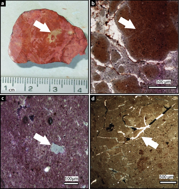
Figure 5. The morphological and petrological features seen in the carbonate nodules. (a) shows sharp dolomitic nodule boundaries and central core (arrowed) from a Type A palaeosol. (b) Photomicrograph of a dolomitic carbonate nodule from a Type A palaeosol with clotted fabric (arrowed). (c) Photomicrograph showing a floating quartz grain (arrowed) surrounded by crypto-microcrystalline calcite from a Type D palaeosol. (d) A photomicrograph showing a sinuous vein (arrowed) filled in with euhedral calcite. The cryptocrystalline groundmass is dolomitic from a Type B palaeosol.
The only exceptions to these are the carbonate layers from the Type C palaeosols (Fig. 4). These consist of 10% very fine sand/silt grade sub-rounded quartz grains surrounded by a groundmass of micritic cryptocrystalline carbonate. Also included within this groundmass are occasional bioclasts such as ostracod fossils preserved in calcite. There are also patches of coarser crystalline calcite approximately 25 μm in diameter, which appear to be roughly spherical in shape and may be fills of spherical voids in the rock or calcified pellets. These carbonate features are similar to those described as beta calcrete microfabrics (Wright & Tucker, Reference Wright, Tucker, Wright and Tucker1991).
XRD on 1312 carbonate samples revealed that most nodules are composed primarily of either calcite or dolomite (see Dataset 1 in the online Appendix at http://journals.cambridge.org/geo). In those nodules that contained dolomite, the microcrystalline and cryptocrystalline parts of the fabric took up the dolomite stain (Fig. 6aii). The dolomite occurs in the primary, micritic part of the nodule (cf. Wright & Tucker, Reference Wright, Tucker, Wright and Tucker1991; Spötl & Wright, Reference Spötl and Wright1992; Quast, Hoefs & Paul, Reference Quast, Hoefs and Paul2006), and is not related to any morphological or petrological variation within the nodules (Fig. 6). Nodules that recorded both a calcite and a dolomite peak using XRD were stained with a calcite-specific stain (Dickson's stain). This demonstrated that the calcite is present in sinuous veins of anhedral to euhedral calcite randomly cutting across most of the nodules. The elongated calcite crystals are 5–15 μm in width and generally 150–50 μm in length. The vein crystals have distinct boundaries from the surrounding micro- and cryptocrystalline groundmass (Fig. 6ai, ciii). These veins may also grow around patches of crypto- and microcrystalline micrite (Fig. 6a, c).
Figure 6. Two petrographic slides both from carbonate nodules from Type A palaeosols (a, c), both stained with dolomite-specific stain, and the respective nodules from which the slides came (b, d). (a) is a dolomitic nodule where (i) is the later calcitic sinuous vein which has not taken up the stain and (ii) is the dolomitic cryptocrystalline groundmass which has taken up the stain. (b) is the nodule from which slide (a) was taken. (c) is a calcite nodule where both the later vein filling calcite (iii) and cryptocrystalline calcite (ix) have not taken up the stain. (d) is the nodule from which slide (c) was cut.
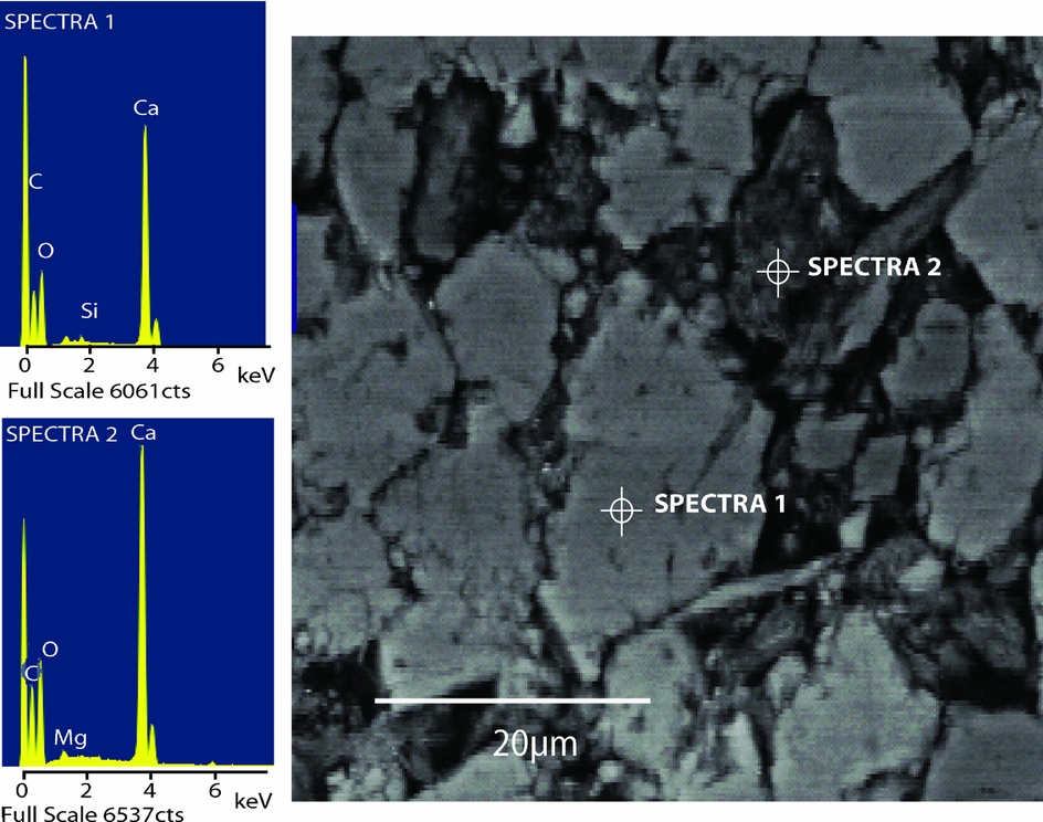
SEM revealed that the areas that make up the densest parts of the clotted texture in the dolomitic nodules are composed of dolomite rhombs of c. 2–5 μm in size (Fig. 7a). Elemental analyses of these areas showed prominent peaks in Ca, C, O and Mg. The sparry vein fill, by contrast, lacks a prominent Mg peak confirming that it is indeed calcite. The calcite crystals envelop the dolomite rhombs (Fig. 7b). SEM carried out on the calcitic nodules shows that the calcitic nodules have slightly larger crystals (c. 10 μm), which have an amorphous shape (Fig. 8). Elemental analyses of these areas showed prominent peaks in Ca, C and O, and other areas show peaks in Si, Al and O, suggesting the presence of quartz or clays (Fig. 8).

Figure 7. SEM results from different parts of a dolomitic nodule from a Type A palaeosol (see photomicrograph on left). Area (a): elemental analysis of a cryptocrystalline area, showing a high Mg peak (Spectra 1). Area (b): elemental analysis of sinuous vein, with no Mg peak (Spectra 2).

Figure 8. SEM results from different parts of the cryptocrystalline part of a calcitic nodule from a Type A palaeosol. The spectra are of the calcitic area (Spectra 1) and areas of clay/silt found in between (Spectra 2).
4.c. Results: isotopes
Isotope values from micritic parts of the dolomitic nodules that have a clotted texture ranged from δ13C +2.60 ‰ to −5.62 ‰ (VPDB) and δ18O +2.52 ‰ to −8.28 ‰ (VPDB), while the calcitic nodules ranged from δ13C +0.46 ‰ to −11.06 ‰ (VPDB) and δ18O −2.52 ‰ to −10.87 ‰ (VPDB) (Fig. 9). The dolomitic micrite δ13C isotope values were on average 3 ‰ more positive than the calcitic micrite, while δ18O values were 6 ‰ more positive. In both cases the calcite and dolomite from Type A, C and D palaeosols have more positive δ18O values. Although in all the sections the vast majority of organic carbon has been oxidized leaving drab root halos and reddened clay, three samples of organic carbon were recovered from Sambullak (Fig. 9) which have an average δ13C organic value of −23.04 ‰.

Figure 9. Isotopic data from the micritic fraction of the pedogenic nodules from the sections in the South Urals, Russia, and the organic carbon values recovered from Sambullak (see Dataset 2 – stable isotope results for values in the online Appendix at http://journals.cambridge.org/geo). The isotopic values for modern pedogenic calcite and dolomite are from Kohut, Muehlenbacks & Dudas (Reference Kohut, Muehlenbacks and Dudas1995) from soils from Alberta, Canada. The grey shaded area is the area of carbonate that can be explained purely by the oxidation of organic matter in the soil (see text).
5. Discussion
Previous studies on the sedimentary facies of the South Urals across the P–Tr boundary have identified that the presence of pedogenic carbonate and root development within these sections is part of a terrestrial fluvial system (Newell, Tverdokhlebov & Benton, Reference Newell, Tverdokhlebov and Benton1999; Surkov et al. Reference Surkov, Benton, Twitchett, Tverdokhlebov and Newell2007). This has been used to suggest the palaeosols formed in a semi-arid to sub-humid environment (Surkov et al. Reference Surkov, Benton, Twitchett, Tverdokhlebov and Newell2007). This interpretation is consistent with the more detailed investigation into the palaeosols undertaken in this study, as the majority of the palaeosols show closest affinity to modern Aridisols, which are found in semi-arid to arid environments (Retallack, Reference Retallack1993, Reference Retallack2001). Previous studies also identify the presence of shallow ephemeral lakes, which are thought to be present in the sections (Newell, Tverdokhlebov & Benton, Reference Newell, Tverdokhlebov and Benton1999). These have also been identified in this study and have shown a level of pedogenic alteration (Fig. 4; Table 1). These lacustrine-influenced Type C palaeosols only represent 7 out of 156 palaeosols identified in this study (see Table 1).
5.a. Origin of dolomite
The origin of dolomite in palaeosols and the processes that allow its precipitation are disputed. Although it has been observed in many palaeosols (e.g. Kessler, Soreghan & Wacker, Reference Kessler, Soreghan and Wacker2001; Capo et al. Reference Capo, Whipkey, Blachère and Chadwick2000; Bustillo & Alonso-Zarza, Reference Bustillo and Alonso-Zarza2007) and some modern soil profiles (Bui, Loeppert & Wilding, Reference Bui, Loeppert and Wilding1990; Kohut, Muehlenbacks & Dudas, Reference Kohut, Muehlenbacks and Dudas1995; Capo et al. Reference Capo, Whipkey, Blachère and Chadwick2000), it is still considered to be exceedingly rare in the geological record (Sheldon & Tabor, Reference Sheldon and Tabor2009).
This study has shown, however, that the Upper Permian palaeosols of the South Urals commonly contain dolomite. Understanding the origins of this dolomite, and the timing of its formation, may shed light on this debate, and have wider implications for our understanding of the palaeosol record.
Petrographic analysis of the nodules shows that they have a clotted texture, which is commonly associated with nodule growth in vadose environments (Wright & Tucker, Reference Wright, Tucker, Wright and Tucker1991; Quast, Hoefs & Paul, Reference Quast, Hoefs and Paul2006) (Fig. 5b). This interpretation is also supported by the presence of ‘floating’ grains of very fine quartz that have been replaced by the growth of carbonate (Khadkikar, Chamyal & Ramesh, Reference Khadkikar, Chamyal and Ramesh2000; Quast, Hoefs & Paul, Reference Quast, Hoefs and Paul2006) (Fig. 5c). The dolomite-specific staining and SEM analyses demonstrate that, in nodules where it occurs, dolomite comprises the microcrystalline and cryptocrystalline parts of the nodules. These micro-crystalline and cryptocrystalline parts of the nodules have clotted textures and alpha fabrics, features (Fig. 5) that have been interpreted by Wright & Tucker (Reference Wright, Tucker, Wright and Tucker1991), Khadkikar, Chamyal & Ramesh (Reference Khadkikar, Chamyal and Ramesh2000), Alonso-Zarza (Reference Alonso-Zarza2003) and Quast, Hoefs & Paul (Reference Quast, Hoefs and Paul2006) to have pedogenic origins. The only carbonate that has a different appearance to this is that from the Type C palaeosols, which contain ostracod fossils and fabrics that may be associated with ephemeral lakes (Alonso-Zarza, Reference Alonso-Zarza2003).
Spar crystals are present in the nodules (Figs 5d, 6ai, 7b) and indicate a later phase of crystallization, which filled in cavities created by shrinking and swelling, or by rootlet action (Wright & Tucker, Reference Wright, Tucker, Wright and Tucker1991; Khadkikar, Chamyal & Ramesh, Reference Khadkikar, Chamyal and Ramesh2000; Quast, Hoefs & Paul, Reference Quast, Hoefs and Paul2006). The spar crystals have distinct boundaries separating them from the surrounding micro- and cryptocrystalline groundmass, suggesting two phases of crystallization, with the spar forming after the groundmass (Fig. 6ai, aii). This indicates that the spar is therefore secondary and formed during diagenesis and lithification. SEM (Fig. 7) and calcite-specific staining (Fig. 6) show that these spar crystals are all calcitic. All of the fabrics associated with diagenesis are characterized by the precipitation of calcite. None of the diagenetic fabrics contain dolomite, and the fabrics that are composed of dolomite are all primary. It is plausible that the dolomite could be an early mimetic replacement of calcite cryptocrystalline groundmass. This would, however, have had to have been very early in the diagenetic history of the carbonate as all the later cements are calcitic. However, in palaeosols where such early dolomitic replacement has been observed such as those described by Gómez-Gras & Alonso-Zarza (Reference Gómez-Gras and Alonso-Zarza2003), an isopachous rim of acicular dolomitic crystals which formed during the diagenetic overprint process is seen. The dolomitic carbonates from the palaeosols in this study show no such overprint (Fig. 6a).
5.b. Lacustrine/groundwater origin
Primary dolomite, formed through surface and groundwater processes rather than diagenetic or metamorphic routes, is usually associated with lacustrine conditions (Watts, Reference Watts1980; Colson & Cojan, Reference Colson and Cojan1996; Bustillo & Alonso-Zarza, Reference Bustillo and Alonso-Zarza2007). The Type C palaeosols which contain dolomite are certainly associated with evidence of lacustrine conditions, such as those occurring with thin, ostracod-bearing limestones (Fig. 4, Type C palaeosols, Table 1). These nodular dolocretes precipitated in the vadose zone as the lakes dried out (Colson & Cojan, Reference Colson and Cojan1996; Alonso-Zarza, Reference Alonso-Zarza2003; Quast, Hoefs & Paul, Reference Quast, Hoefs and Paul2006). Previous studies have inferred the presence of ephemeral lakes and ponds during Late Permian time in the study area from sedimentological evidence (Newell, Tverdokhlebov & Benton, Reference Newell, Tverdokhlebov and Benton1999). The evaporation of such ephemeral lakes and ponds would produce Mg-rich waters, which would precipitate dolomite rather than calcite (cf. Calvo et al. Reference Calvo, Jones, Bustillo, Fort, Alonso-Zarza and Kendall1995). Elevated carbonate/bicarbonate concentrations in the lake waters would result in the direct precipitation of cryptocrystalline dolomite (cf. del Cura et al. Reference Del Cura, Calvo, Ordóñez, Jones and Cañaveras2001).
The majority of dolomite nodules from the Upper Permian of the South Urals are, however, not associated with evidence of lacustrine conditions (Fig. 10). They occur in palaeosols identified as Aridisols and Vertisols (Type A and Type B palaeosols, Table 1) containing Stage II carbonate nodules, which are morphologically identical to palaeosols containing just calcite nodules (Table 1; Fig. 10). The dolomite is also present in Stage III, V and VI developed calcretes. All Type A and B palaeosols are well rooted throughout with branching rootlets, indicating that the soil could not have been waterlogged for a prolonged period. Equally, Type A and B palaeosols show no evidence of gleyed horizons, which if present would indicate permanent water logging of these palaeosols (cf. Retallack, Reference Retallack2001). The evidence indicates that the dolomite present in those palaeosols could not have formed through the influence of lacustrine waters.
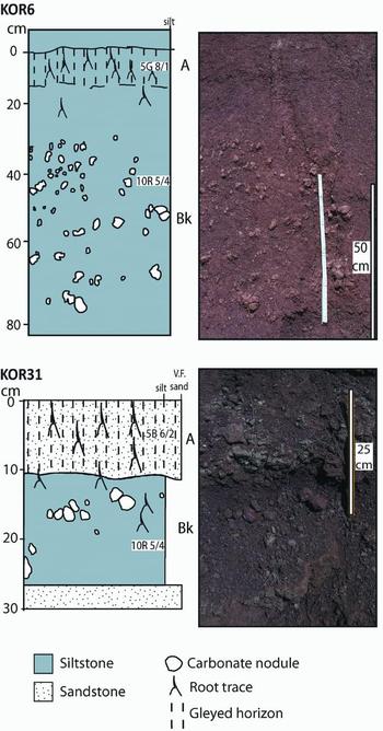
Figure 10. Two Type A palaeosols from Boyevaya Gora where the carbonate is of pedogenic origin. KOR6 shows a pedogenic dolomitic palaeosol that is very similar to the palaeosol seen in KOR31, which is entirely calcitic (see Dataset 1 − XRD results in the online Appendix at http://journals.cambridge.org/geo).
Geochemistry may provide an additional means of determining whether individual palaeosols formed under waterlogged conditions. Based on their interpretations of the isotopic signature of calcitic palaeosols, Tabor et al. (Reference Tabor, Montanez, Steiner and Schwindt2007) argue that in a Karoo Basin Permian–Triassic section, palaeosols were isolated from the atmosphere during their formation, under permanently waterlogged conditions. The authors argued that δ13C values of pedogenic calcite that fall within +14.8‰ of the δ13C isotopic composition of co-occurring organic matter can be entirely explained through the CO2 produced during oxidation of organic matter in a closed system (Tabor et al. Reference Tabor, Montanez, Steiner and Schwindt2007).
If this argument is applied to the South Urals palaeosols, using δ13C values of organic carbon recovered from Sambullak (Fig. 9), then any calcite with δ13C values below −8.24 ‰ (VPDB) could have formed in a closed system, under waterlogged conditions, and thus have a groundwater origin. Although, some calcitic nodule isotope values do fall within this field (Fig. 9), they are mainly from Triassic Alfisols (Type F palaeosols) and Triassic groundwater Aridisols (Type E palaeosols) in the Mescheryakovka section, which also have obvious morphological evidence for a groundwater origin and are very different in morphology to the Sedibo palaeosols (cf. Retallack, Smith & Ward, Reference Retallack, Smith and Ward2003) analysed by Tabor et al. (Reference Tabor, Montanez, Steiner and Schwindt2007). The geochemical data therefore suggest that the majority of the studied palaeosol nodules do not have a groundwater origin, but instead formed in an open system in equilibrium with atmospheric CO2. It has also been observed that positive linear covariant trends observed between δ13C and δ18O similar to that observed in the South Urals palaeosols (Fig. 9) is indicative of carbonate formed in an open vadose system (Ufnar, Gröcke & Beddows, Reference Ufnar, Gröcke and Beddows2008).
Furthermore, the relatively positive δ13C value for the organic matter recovered from the section at Sambullak may indicate arid conditions as in such conditions, reduced photosynthetic fractionation under water-stressed conditions leads to more positive isotopic values (Bestland & Krull, Reference Bestland and Krull1999; Wynn, Reference Wynn2007). There are also a cluster of Permian Aridisols with δ13C values below −8.24 ‰ (VPDB). These samples also have δ18O values below −8.00 ‰ (Fig. 9), which has been observed in other Permian sections (Ghosh, Ghosh & Bhattacharya, Reference Ghosh, Ghosh and Bhattacharya2001; Tabor et al. Reference Tabor, Montanez, Steiner and Schwindt2007) and may be related to extreme atmospheric conditions associated with the mass extinction.
It has been noted that in marine and lacustrine environments mimetic dolomite can replace original fabrics and textures such as micrite at low temperatures (Vahrenkamp & Swart, Reference Vahrenkamp and Swart1994; Williams & Krause, Reference Williams and Krause1998). It is therefore possible that evaporating lacustrine waters could result in the formation of microcrystalline dolomite as a replacement fabric for original calcite. In this study, however, the section at Tuyembetka has 28 palaeosols containing apparent pedogenic dolomite (Fig. 11), and this section has no evidence for lacustrine deposits or Type C palaeosols. Several lines of evidence suggest that Tuyembetka represents a palaeohigh. In the uppermost Permian of Tuyembetka there are many more very well-developed (mature) palaeosols (Fig. 3), and fewer fluvial channels than at other sections studied. In addition, palaeomagnetic studies also show that this section is highly condensed compared to other sections in the basin (Taylor et al. Reference Taylor, Tucker, Twitchett, Kearsey, Benton, Newell, Surkov and Tverdokhlebov2009). Equally those pedogenic dolomites that occur just beneath the P–Tr boundary at Boyevaya Gora are not associated with any evidence of lacustrine deposits, although such deposits do occur much lower in the Permian at that section (the Type C palaeosols). Thus we conclude that the pedogenic dolomite horizons in the Upper Permian of the South Urals are not caused by mimetic replacement by evaporative lacustrine waters as they are texturally distinct from the lacustrine-influenced Type C palaeosols and they show an isotopic signal indicative of carbonate formed in an open vadose system.

Figure 11. Stratigraphic distribution of calcite, lacustrine dolomite and pedogenic dolomite in palaeosols from Boyevaya Gora, Tuyembetka, Sambullak Buzulukskoe, Petropavlovka and Mescheryakovka. Palaeomagnetic data from Taylor et al. (1999). The line graph on the far left shows percentage of the pedogenic dolomitic palaeosols across the basin for the specific chron. Arrowed E indicates position of mass extinction horizon, from the global composite magnetostratigraphic correlation of Hounslow et al. (Reference Hounslow, Peters, Mørk, Weitschat and Os Vigran2008).
5.c. Pedogenic origin
Multiple lines of evidence thus indicate that the dolomite present in Type A and B palaeosols in most Upper Permian sections from the South Urals was precipitated as a primary mineral phase during pedogenesis. Primary, pedogenic dolomite nodules not associated with ephemeral lakes are very rare. Pedogenic dolomite has been identified in modern soils, associated with weathered basaltic rocks producing elevated Mg/Ca ratios (Capo et al. Reference Capo, Whipkey, Blachère and Chadwick2000). There is no petrographic evidence of tephra or other volcanic or basaltic material in the pedogenic dolomite palaeosols from the South Urals, ruling out this as a cause of the pedogenic dolomite. Pedogenic dolomite has also been identified in modern-day saline soils from Alberta where it is present as well-ordered crystals in the finest < 2 μm fraction of the soil, which formed in isotopic equilibrium with the atmosphere (Kohut, Muehlenbacks & Dudas, Reference Kohut, Muehlenbacks and Dudas1995). The isotopic composition of this dolomite has an average δ13C value of −3.07 ‰ and average δ18O value of –3.37 ‰ (Kohut, Muehlenbacks & Dudas, Reference Kohut, Muehlenbacks and Dudas1995), which is similar to the isotopic values recorded in the Upper Permian dolomitic nodules in this study (Fig. 9).
The isotopic data from the Upper Permian and Lower Triassic palaeosol nodules analysed in this study show some overlap between the dolomite and calcite isotopic values (Fig. 9). Although one might expect more of a separation between these two fields, perhaps as much as +2–4 ‰ in the δ18O values between the dolomite and calcite due to differences in isotopic fractionation (Goldstein pers. comm.), it is worth noting that the isotope values from unaltered, modern soils from Alberta also record some overlap between the dolomite and calcite fields (Fig. 9; Kohut, Muehlenbacks & Dudas, Reference Kohut, Muehlenbacks and Dudas1995). In addition, Upper Permian–Lower Triassic palaeosols record dramatic fluctuations in both the δ18O and δ13C values of precipitated carbonate (MacLeod et al. Reference MacLeod, Smith, Koch and Ward2000; Ward et al. Reference Ward, Botha, Buick, De Kock, Erwin, Garrison, Kirschvink and Smith2005; Coney et al. Reference Coney, Reimold, Hancox, Mader, Koeberl, McDonald, Struck, Vajda and Kamo2007), reflecting isotopic changes in the atmosphere (Retallack et al. Reference Retallack, Metzger, Greaver, Jahren, Smith and Sheldon2006). Given that the South Urals dataset comprises palaeosol nodules from 156 different stratigraphic horizons through the Permian–Triassic interval, the ranges of the calcite and dolomite fields would be expected to be far greater than in the modern and overlapping fields.
The presence of dolomite in the Alberta soils is thought to due to high carbonate ion concentration, elevated Mg/Ca ratios, and low sulphur dioxide concentrations in the saline pore waters formed in evaporative environments (Kohut, Muehlenbacks & Dudas, Reference Kohut, Muehlenbacks and Dudas1995). Earlier studies have also postulated that evaporation and Mg/Ca ratios are important in dolomite precipitation. Watts (Reference Watts1980) suggested that, in times of increased evaporation, Mg will inhibit calcite nucleation and, if evaporation is greater than calcite nucleation, the Mg/Ca ratio would remain constant but the salinity would increase. Dolomite is then precipitated by ‘forced crystallization’. Thus it is likely that extreme evaporation, due to prevailing climatic changes, was one of the major controls on dolomite precipitation in the Upper Permian palaeosols.
Pedogenic dolomite is also more common in localities that are further away from the active channels, such as Tuyembetka. The presence of both dolomite and calcite within the same section, such as at Boyevaya Gora and Sambullak (Fig. 11), is possibly also related to temporal changes in the position of river channels and the proximity of individual palaeosols to the active palaeo-channel. Pedogenic nodules composed of calcite form closest to active channels, due to the raised water table producing damper soils (cf. William & Krause, Reference Williams and Krause1998).
Dolomite precipitation in the Upper Permian palaeosols from the South Urals may also have a biological control. Microbes have an important role in the formation of carbonate in modern soils and their presence leads to the development of characteristic clotted fabrics (e.g. Monger et al. Reference Monger, LeRoy, Lindemann and Liddell1991) Very similar clotted fabric textures are observed in the Upper Permian palaeosols in this study (Fig. 6b). Experiments using microbial cultures in both the field and laboratory have shown that the formation of dolomite through surface processes also requires the presence of certain bacteria (Roberts et al. Reference Roberts, Bennett, Gonzalez, Macpherson and Milliken2004; Sánchez-Román et al. Reference Sánchez-Román, Vasconcelos, Schmid, Dittrich, McKenzie, Zenobi and Rivadeneyra2008) and this has also been observed in modern ephemeral lakes in South Australia (Wacey, Wright & Boyce, Reference Wacey, Wright and Boyce2007). Therefore, it is plausible that the microbial communities living in the Upper Permian palaeosols of the South Urals may have played a central role in the formation of the dolomite recorded in the palaeosols in this study, although no evidence of such bacteria has been preserved in the palaeosols.
Finally, atmospheric conditions may also be crucial in the formation of primary dolomite. It has been suggested that elevated atmospheric pCO2 levels may cause the formation of dolomite rather than calcite in soils (Retallack pers. comm.). This is based on the observation that the carbonate precipitated in palaeosols during times of high atmospheric pCO2, such as during Precambrian time, is dolomitic rather than calcitic (Retallack & Minsdzenty, Reference Retallack and Mindszenty1994; Retallack, Reference Retallack2001). Possibly it is because elevated atmospheric pCO2 levels cause an increase in temperatures, and this increase in temperature may have made the precipitation of dolomite more kinetically likely (Arvidson & Mackenzie, Reference Arvidson and Mackenzie1999). It is known that atmospheric pCO2 was much higher across the P–Tr boundary than modern atmospheric levels (Retallack & Jahren, Reference Retallack and Jahren2008) and thus there was an increase in temperature.
If atmospheric or climatic conditions did control pedogenic dolomite formation, then the occurrence of primary, pedogenic dolomite in Upper Permian palaeosols should not be restricted to the South Urals Basin. Benito et al. (Reference Benito, de la Horra, Barrenechea, López-Gómez, Rodas, Alonso-Azcárate, Arche and Luque2005) and de la Horra et al. (Reference de la Horra, Benito, López-Gómez, Arche, Barrenechea and Luque2008) recorded dolomicrites in Upper Permian sections in the Iberian Ranges of Spain. While much of the dolomite observed in these Spanish sections has been attributed to a later diagenetic overprint (Gómez Gras & Alonso-Zarza, Reference Alonso-Zarza2003; Benito et al. Reference Benito, de la Horra, Barrenechea, López-Gómez, Rodas, Alonso-Azcárate, Arche and Luque2005) the observation of dolomicrites in some of the profiles has been used to suggest that they were originally developed as dolocretes in an arid to semi-arid climate (Benito et al. Reference Benito, de la Horra, Barrenechea, López-Gómez, Rodas, Alonso-Azcárate, Arche and Luque2005; de la Horra et al. Reference de la Horra, Benito, López-Gómez, Arche, Barrenechea and Luque2008). If this interpretation is correct then the presence of primary dolomicrite in both Spain and the South Urals, at the same time, would suggest that this phenomenon is not just related to local basin conditions, but may relate to larger-scale climatic trends.
5.d. Stratigraphic distribution of dolomite
Pedogenic dolomite and calcite are not evenly distributed through the sections. There is an increase in the frequency of pedogenic dolomite, with respect to calcite, up-section, and dolomitic palaeosols are most prevalent in the uppermost Changhsingian just beneath the P–Tr boundary (Fig. 11). Palaeosols above the P–Tr boundary contain no dolomite (Fig. 11).
The stratigraphic distribution of dolomite provides further evidence for a primary pedogenic origin for the dolomite (Fig. 11). If all the palaeosols had originally been calcitic and later replaced by dolomite, the dolomite should be present in both the Permian and Triassic palaeosols. There is no significant time gap between the Permian and Triassic strata of the study area (Taylor et al. Reference Taylor, Tucker, Twitchett, Kearsey, Benton, Newell, Surkov and Tverdokhlebov2009), and therefore the Permian and Triassic strata cannot have experienced different burial histories. Equally there is no evidence of such features as isopachous rims of dolomitic angular phreatic cements in the Permian dolomitic nodules that may suggest different diagenetic histories. The presence or absence of dolomite is therefore related to the primary properties of the palaeosols and their environment.
The occurrence of possible pedogenic dolomite in the Upper Permian of Spain has also been used as evidence for an arid to semi-arid climate with marked seasonality (Benito et al. Reference Benito, de la Horra, Barrenechea, López-Gómez, Rodas, Alonso-Azcárate, Arche and Luque2005). In Spain, however, the dolomite disappears by the Changhsingian and it is thought that conditions became more humid towards the P–Tr boundary (de la Horra et al. Reference de la Horra, Benito, López-Gómez, Arche, Barrenechea and Luque2008). In the South Urals the pedogenic dolomite does not disappear until after the P–Tr boundary (Fig. 11), suggesting a later onset of more humid conditions in the South Urals. Although more studies are needed, these regional differences may indicate northward shift of climatic belts through the Changhsingian interval.
The complete absence of Lower Triassic dolocretes may indicate that evaporation rates and seasonality were reduced in the study area in earliest Triassic time, compared to the situation in latest Permian time. The change from meandering rivers to braided river systems observed in the South Urals across the P–Tr boundary meant that there would have been an increase in the rate of surface runoff, greater flood peaks (Newell, Tverdokhlebov & Benton, Reference Newell, Tverdokhlebov and Benton1999) and potentially wetter soils during Early Triassic time as rivers were no longer constrained in meandering river channels. This interpretation is supported by the occurrence of gleyed soils in the Triassic (Palaeosols Type E and F, Table 1), suggesting higher water tables and the presence of anoxic standing water. This increased soil moisture would have likely resulted in the precipitation of calcite rather than dolomite. An alternative hypothesis is that pedogenic dolomite formation is not primarily controlled by extreme evaporation, and that soil conditions changed dramatically across the P–Tr boundary as a result of the mass extinction.
7. Summary
A combination of analyses has demonstrated the unequivocal presence of primary dolomite in unaltered pedogenic nodules from the Upper Permian (Changhsingian Stage) of the South Urals, Russia. Dolomite is also associated with lacustrine deposits formed during evaporation of ephemeral lakes or ponds in a semi-arid setting. The presence and distribution of pedogenic dolomite indicate that immediately prior to the P–Tr boundary in this region there was an increase in seasonality and extreme evaporation. A change to purely calcitic palaeosols in earliest Triassic time may reflect (a) hydrological changes possibly related to the dramatic change in river morphology observed in the South Urals by Newell, Tverdokhlebov & Benton (Reference Newell, Tverdokhlebov and Benton1999), (b) reduction in evaporation rates and seasonality in the study area, and/or (c) disappearance of the soil microbes that are necessary for dolomite formation.
Acknowledgements
TK was funded through a University of Plymouth, Faculty of Science Ph.D. Studentship, which also funded all laboratory analyses. TK thanks S. T. Grimes, G. D. Price, P. A. Sutton and R. M. Moate for discussion and assistance in the laboratory. Samples were collected during fieldtrips funded by National Geographic (7469-03) (2004) and NERC (NE/C518973/1) (2006). Thanks to G. K. Taylor for discussion of the palaeomagnetic data. M. J. Benton, M. Surkov and V. Tverdokhlebov are thanked for assistance in the field and logistic support. We would like to thank Prof. G. J. Retallack and Prof. G. S. Soreghan for critical comments on an earlier draft of the manuscript. We thank two anonymous reviewers for their reviews of this paper.