


Introduction: Infrastructure Design and Territorial Transformation
This article delves into the processes of territorial transformation, and indeed territorial integration, by foregrounding the material dimension of infrastructure. More specifically, the entry of the research is infrastructure network design and planning. We will trace the concepts of territorial transformation inscribed into the material layout of large technical systems by analyzing the discourse of engineers and policy makers involved in the conception of infrastructure networks. In so doing, the material politics of infrastructure networks will be studied: How did engineers and policy makers design infrastructure to generate a specific territorial transformation? Moreover, how did technological plans hold the idea that one could influence modernization processes by means of a territorial transformation instigated by infrastructure? The neutral status of technology is thus fundamentally challenged by showing that engineers, in association with policy makers, were essential actors in the planned transformation of the territory as they organized infrastructure networks according to specific ideas relating spatial and societal transformation. As Marc Desportes and Antoine Picon remark in their review on the organization of the French territory, “in the course of the last two centuries, the ties between space and society have been the object of a series of redefinitions, the genesis of planning at the end of the Second World War represents only one of them” (Desportes and Picon Reference Desportes and Picon1997: 13). From the nineteenth century onward, “the notion of the organization of the territory in fact presuppose[d] that one could act on society by the intermediary of a well-though-out transformation of the territory by means of infrastructure” (ibid.). Also in Belgium, it was the engineer who was charged with the duty of organizing and integrating the nation, or better, of fundamentally reshaping the territory to adapt it to the new needs of an emerging industrial nation. This tripartite of engineering, territorial organization, and societal transformation was especially prominent in postrevolutionary Belgium.
After the Belgian Revolution of 1830, both engineers and policy makers explicitly forwarded infrastructure as the quintessential instrument to spatially integrate and organize a divided postrevolutionary society (De Block Reference De Block2011). The mission statement that prefaces the first issue of Annales des travaux publics de Belgique—the periodical of Belgian Public Works—highlights the socioeconomic and cultural dimension of infrastructure networks as “elements of pubic prosperity” and concludes with an overt political ambition for the engineering corps, referring to Ovid from Metamorphoses: “May Providence do for us, generation emerged from the chaos of the revolutions, what it has done for the elements emerged from the chaos of the world: Dissociata locis concordi pace ligavit. [What has been separated, I have united in harmonious peace]”Footnote 1 (Guillery Reference Guillery1843: 10). Similarly, contemporary political discourse had a penchant for portraying infrastructure networks as the symbolic and political embodiment par excellence of independence, as a means to construct and secure the collective myth of national union, progress, and emancipation (De Block Reference De Block2011). The revolt of Catholics and liberals united against the regime of King Willem I of the Verenigd Koninkrijk van de Nederlanden led to the pullout of Dutch troops in 1830, but did not lead unilaterally to a fixed, independent nation-state. The proclaimed independent Belgian nation and the Netherlands remained on a war footing for the greater part of the 1830s. It was only after several international interventions, both diplomatic and armed, that Willem I officially recognized Belgium in 1839. During this period of political instability leading up to the Treaty of London (1839), the physical spatial extent of the Belgian territory was key in political negotiations, with the division of the former Dutch Province of Limburg (North-East) and Grand Duchy of Luxemburg (South-East) as well as the access to the harbor of Antwerp via the river Scheldt (North-West) as objects of discussion. In addition, during this insecure period, the provisional government of Belgium was composed of the ideological opposites of Catholics and liberals that “only agreed on one thing: ousting William I because he was too protestant for the former and too despotic for the latter,” political historian Maarten Van Ginderachter explains (Van Ginderachter Reference Van Ginderachter2019: 12); this was a political setting in which finding a compromise was the central political strategy. In her work on the political history of Belgium, Els Witte clarifies that during the first years of Belgium, political life was characterized by unionisme. In the context of the politics of consensus, issues of trade, industry, and finances were popular subjects in Parliament; social norms, however, were avoided as much as possible (Witte Reference Witte1985: 76). Accordingly, the first endeavors of the provisional government were geared at practical solutions to politico-economic problems, thus avoiding abstract ideological discussions that could harm the fragile union between liberals and Catholics (Witte Reference Witte1985). Infrastructure projects, and more accurately the ideas of territorial integration inscribed in these projects, served both as a collective challenge against former foreign rulers and as the glue around which ideological opposites could gather and take action (see also Swyngedouw Reference Swyngedouw2015). Infrastructure was thus perceived as the instrument par excellence of the postrevolutionary era.
The concepts of nation building and modernization have been the dominant entry into the history of technology, and the history of infrastructure networks more specifically. Many historical works have shown by means of political discourse and cultural representation that nation-states and empires actively deployed infrastructure networks to build and strengthen their economies and identities (e.g., Bess Reference Bess2014; De Block Reference De Block2011; Divall Reference Divall, Burri, Elsasser and David2003; Ficek Reference Ficek2016; Høgselius et al. Reference Høgselius, Kaijser and van der Vleuten2015; Martí-Henneberg Reference Martí-Henneberg2017; Moraglio Reference Moraglio2017a; van der Vleuten and Kaijser Reference van der Vleuten and Kaijser2005; Weber Reference Weber1977). Yet, infrastructure design is generally depicted as the straightforward and clean translation of the abstract and grand rhetoric of national socioeconomic and political ideals. Reviews in the field of transport history have raised awareness of the dominant focus on the one-dimensional relation between infrastructure and the development of a modern society using infrastructure as a cultural metaphor for modernization and integration (Divall and Revill Reference Divall and Revill2005, Reference Ficek2006; Mom Reference Mom2003). Recent work has argued for a history that brings in asymmetrical and contested relations between transport infrastructure, modernization, and territorial transformation (e.g., Gandy Reference Gandy2014; McCants et al. Reference McCants, Eduardo, Cordeiro and Lourenco2011–13; Moraglio Reference Guldi2017b; Pereira Reference Pereira2018; Swyngedouw Reference Swyngedouw2015). More specifically, infrastructure plans and their designers are forwarded as key actors in the genesis of infrastructure networks negotiating conflicting ideas and interests about sociospatial development. Instead of considering the engineer as a docile expert who objectively and efficiently translates the initial political assignment into a plan, the design(er) is approached as an influential actor including ideas of sociospatial transformation into the technical plans. Although a number of recent studies focus on the material dimension of infrastructure and highlight the important role of the engineer and the technical plan in the history of technological systems by studying the infrastructure as “sociotechnical hybrid” and the engineer as “sociotechnician” (Björkman and Harris Reference Björkman and Harris2018; Guldi Reference Guldi2012; Merriman Reference Merriman2007; Mukerji Reference Mukerji2009; Picon Reference Picon1992; Zeller Reference Zeller2007), few studies analyze both sides—the technical and the social, or the material and political—equally. They often tend to the sociopolitical in the dialectic and pay limited attention to the material side, or to the engineering discourse and the inscribed relations between technology and space. Consequently, when these studies do incorporate the material in their analysis, the embedded visions on the territory or space more generally remain abstract and rarely exceed political rhetoric, or the sociotechnical analysis is more focused the technological construction of space—the effects—(Divall and Revill Reference Divall and Revill2005, Reference Ficek2006) rather than on the spatial construction of technology—the intention. Similarly, in the domains of social history and urban history, the effects of infrastructure are mainly examined (e.g., Atack et al. Reference Atack, Bateman, Haines and Margo2010; Gregory and Martí-Henneberg Reference Gregory and Martí-Henneberg2010; Schwartz Reference Schwartz2010), with less attention for the potential intentional character of the flows and sociospatial development generated by infrastructure, or indeed the material politics of infrastructure networks.
This article will contribute to these bodies of literature by focusing on the material politics of infrastructure networks; an approach explicitly connecting infrastructure design with ideas about spatial territorial organization as means to respond to geopolitical problems and ambitions. We will focus on the two decades after the independence of Belgium (1831), when engineers, in close alliance with policy makers, conceived comprehensive networks of rails, waterways, and roads with the intention to safeguard the recent political revolution. More specifically, the material politics of infrastructure networks were geared at internally organizing national territory as well as positioning Belgium as a new nation between the established powers of France, England, Germany, and the Netherlands. The network designs had to combine the geopolitical goals of, on the one hand, integrating the national territory by facilitating industrial development in its core and internally colonizing the disputed peripheral territories of Limburg, Luxemburg and the river Scheldt, while, on the other, bolstering the politico-economic position of Belgium within Europe. To attain these goals two major public works initiatives were formulated in the 1830s and materialized throughout the 1840s: (1) the centrally positioned railway network that connected all industrial centers within the territory as well as with the markets of neighboring countries, positioning Belgium into Europe as international turntable, and (2) a network of roads and canals in peripheral, so-called unproductive, regions that had to integrate these regions within national borders, and indeed extend these borders, as well as buffer and govern the side-effects and risks generated by the accelerating industrialization in the central parts of the nation. The following analysis will focus on the conception of these networks, tracing the material politics behind the infrastructure networks. We will analyze the design of the networks focusing on how the design was influenced by ideas relating spatial and societal transformation, and indeed territorial integration.
Conceiving the Crossroads of Europe and Belgium: The Railway Network
[W]ithout the Revolution the railway could not have been realized; and without the railway, the Revolution could have been jeopardized. (Briavoinne Reference Briavoinne1839)
In contrast to the traditional Westphalian premise of territory, illustrated markedly by Vauban’s Pré Carré architecturally articulating the power of the nation in monumental fortifications (Desportes and Picon Reference Desportes and Picon1997: 23), in nineteenth-century Belgium the notion of territory was closely related to concepts of circulation, rather than a formalist logic of territorial organization. As a small, recently independent nation (1831) amidst the then world powers of France, England, Germany, and the Netherlands, Belgium had to secure its political revolution (1830) and literally fix its borders by positioning itself as a transnational hub. Otherwise, “we shall perish like a plant without water,” King Leopold I wrote to Lord Palmerston, the English secretary of state for Foreign Affairs who had a key role in the international negotiations about the Belgian borders (Stengers Reference Stengers1968: 584–85). As both the opening to the sea via the river Scheldt and the waterway connection with Germany were temporarily inaccessible due to the conflict with the Netherlands, an infrastructure project connecting Scheldt and Rhine over Belgian terrain was thus of vital importance for the new nation. It would safeguard international trade, reinstate Antwerp as an international commercial harbor, and thereby strengthen Belgium’s position as a nation within Europe. Besides this economic positioning in Europe, the infrastructure project could also strategically serve as a basis for the international negotiations about the national borders between Belgium and the Netherlands. Jean-Baptiste Nothomb, for instance, who was at the time permanent secretary of the Ministry of Foreign Affairs, presented the connection between Antwerp and Rhine as a valid argument to incorporate the entire Dutch province of Limburg, with the border town of Maastricht, in the Belgian territory, or at least claim sovereignty over the commercial routes running through this region (ibid.). Efficient international exchange not only was brought into play during the negotiations to physically consolidate and expand the territory but it also became the linchpin that would allow the notion of territory to take shape in national policy. What started out as a design for a single line between Antwerp and Cologne, between Scheldt and Rhine (see figure 1), evolved in four years’ time into a railway cross interconnecting all Belgian industrial regions and towns with their national and international markets as well as facilitating transit trade and migration between European nations (see figure 1).

Figure 1. The evolution of the railway design from an efficient connecting line between Scheldt and Rhine to a European and national crossroads.
Source: Author.
The combination of the national and international scope determined the official starting point of the infrastructure project in 1830. The article “Chemin de fer d’Anvers à Cologne. Influence du chemin de fer sur le dévelopement du commerce et de l’industrie,” which was published December 1, 1831 in the official governmental newspaper Moniteur belge, illustrates this discourse well. Engineer Auguste de LaveleyeFootnote 2 did not only materialize the twin goals of international reorientation and national progress, but also translated the latter motive in an expansion of the project’s physical dimension. De Laveleye stated that besides a communication extérieure, a communication intérieure also had to be designed that spanned from the Belgian coast (and not only from Antwerp) to the German border. This inland railway line, which connected the two industrial complementary parts of the country, should lead to a general economic growth spreading out over the entire territory. The twin goals of positioning Belgium within Europe and facilitating the emerging national industry, not only convinced a group of influential politicians to specifically lobby for a railway as soon as 1831, but also incited the government to get fully involved in the project and not leave the initiative to private entrepreneurs, city councils, or Chambers of Commerce (De Brulle Reference De Brulle1967; Discailles Reference Discailles1892–95; Simons and De Ridder Reference Simons and De Ridder1833a; Stengers Reference Stengers1968). Although Belgium was a “hyperliberal” state, assessed as the most liberal of European nations, with minimal central functions and most responsibilities moved to the local level of the municipality (Van Ginderachter Reference Van Ginderachter2019: 11), the division between state and market was not clear-cut (Aerts et al. Reference Desportes and Picon1990; Vanthemsche Reference Vanthemsche1998). Historian Guy Vanthemsche described nineteenth-century Belgian politics as paternalistic liberalism in which the state built the “décor for the market economy,” with infrastructure as one of the key instruments (Vanthemsche Reference Vanthemsche1998). From the end of 1830 onward, the infrastructure project became a prime concern in political circles as the connection between Scheldt and Rhine was considered as the backbone of national economic development. The national project had to construct an “intimate link between future prosperity and the independence of the nation,” as state engineers Pierre Simons and Gustave De Ridder argued to skeptical colleagues who did not believe in a top-down planning approach or governmental intervention (Simons and De Ridder Reference Simons and De Ridder1833b). More specifically, renowned waterway engineers Vifquain and De Puydt advocated against the railway project of Simons and De Ridder from the start, arguing against a railway connection through the central parts of the country. Instead they proposed a waterway through the peripheral and underdeveloped Campine region, thus balancing growth instead of increasing “inequality in such a repulsing way that even the most severe political consideration could never justify it” (De Puydt March 12, 1834). Engineer De Puydt also favored networks growing organically, from bottom-up, driven by local initiative, and critiqued a top-down designed network with government funding, which proposed “to build a large route for export, before providing a means to augment the value of the products” (ibid.). Despite De Puydt’s repeated interventions in Parliament and many other influential voices arguing for the liberal principles of laissez-faire, the government put the early proposals of private actors aside and formulated a wide-ranging project definition, leaving the transport mode and its layout, entirely to state engineers to determine. This decisive, yet broad-minded attitude of policy makers can be associated with the general mentality of the revolution generation of which many members of the government were part (Witte Reference Høgselius, Kaijser and van der Vleuten2005). These politicians, mainly young intellectuals, had made an explicit choice that went beyond their individual agenda during the period of revolutions, and this ideological commitment had left a profound impression that would shape the rest of their careers (Picon Reference Harvey2002; Witte Reference Witte1985). Most of the men who revolted against the rigidity and nepotism of former regimes were imbued with the virtues of rationality and consultation rather than tradition and hierarchy. They felt responsible for reviving Belgium, for offering the new nation the promise of a prosperous future, and, above all, for dedicating this future to the public good instead of to an elite (Witte Reference Witte1985: 74). Thus, rather than straightforwardly choosing for the technically feasible waterway connection that had already been designed by engineers under French and Dutch rulers, the government questioned the familiar and was confident that the rational state engineer would choose and design a transport mode that accurately translated the various geopolitical goals.
Although the government initially assigned engineers Simons and De Ridder the task of drawing up a plan for the most direct and thus least expensive line between the Scheldt and Rhine Rivers, each refused to play the docile technician and instead developed a planning strategy to transform the straight line to a network logic. To achieve this transformation, Simons and De Ridder based their design on a gravitational logic that sidelined efficiency factors like length and topography, and instead focused on the valuation of industrial areas (Simons and De Ridder: Reference Simons and De Ridder1833a). Because the entire nation would be traversed, it was of the utmost importance to assess which routes would be most advantageous. Therefore, benefits coupled to place—or better, considerations of the growth potentials of local economies—were given priority over strictly engineering factors. Simons and De Ridder had a distinct preference for areas in the center of Belgium in which industrialization was settling and developing, even if this would ultimately entail a more expensive project, because it would take a long time and enormous amounts of capital to develop uncultivated areas (Simons and De Ridder Reference Simons and De Ridder1833a: 29–30). They believed that improving the infrastructure in already dynamic areas would stimulate the entire nation, as indicated in their rejoinder to Vifquain, who wanted to build up the underdeveloped Campine region, along the Northern border with the Netherlands: “Before thinking of creating a new country and a new population, it is essential to commence with capacitating the already populated and industrial places in order to withstand foreign competition; it is by first protecting and increasingly ameliorating its principal commercial centers that England succeeded in opening the whole world to the products of its industry” (Simons and De Ridder Reference Simons and De Ridder1833b: 54). It is clear that Simons and De Ridder wished primarily to facilitate the national economy by enhancing what already existed rather than creating new development. The Belgian railway was envisioned as a catalyst for progress (De Block Reference De Block2011).
Besides the politico-economic importance of accommodating existing flows, the conception of the Belgian territory as an international crossing was also a strategic choice within the context of postrevolutionary Belgium in which the young state was reinventing both itself and the tensions with its neighbors (Stengers Reference Stengers1968). National distinctiveness was, paradoxically, imagined around internationalization, the idea of Belgium as a European crossroads between Romanic and Germanic civilizations (Tollebeek Reference Tollebeek2010: 189). The ambitious, even technologically sublime, project had to dispel the prejudices about the Belgian provinces seceding from the thriving power of the Netherlands and, instead, divert the attention to the new nation’s confidence in a progressive and prosperous future within an interconnected Europe. Defending the project in Parliament, cabinet leader Rogier, underscored the importance of the railway for Belgium, gaining centrality in Europe:
The travel in Belgium of Belgians and foreigners will become much more frequent. Similarly, to the material exchanges, the intellectual exchanges will occur with much more ease. … Already for my part I have presented the political importance that it will have for the country to connect in one common centre, our four principal cities, … to unite Ghent, Liège, Antwerp and Brussels in one single city, of which the railway will be the main street…. It is to the glory of Belgium, one of the most industrial regions of Europe, to raise such a monument. (Rogier March 17, 1834)
In contrast to the militant tone and actions in which the negotiations about international waterways and borders were carried on, the representation of the project in the public domain centered on the universal values of amity and exchange represented by the railway, and by extension of the nation Belgium. While in fact revolution and subsequent political negotiations about the waterway connection to Germany over Dutch territory, or indeed national competition, incited the project, announcing articles published by the government publication the Moniteur belge and other pro-Belgian journals in the early 1830s as well as evaluations of the project in the late 1830s and early 1840s portrayed the railway as “the triomphe of the principles of 1789” (Perrot Reference Perrot1844) facilitating the creation of a unified and peaceful Europe (see Moniteur belge April 16, August 28, September 17, 1833). In the same vein, railway engineers Simons and De Ridder foregrounded European peace in their retrospective volume about the conception of the railway cross (1839: 1):
All questions of political economy, at the point where civilization has arrived, are summarized in one key fact: the ease and development of communication. It is the principle and foundation of the real industrial politics. The conception of the railways offers a practical solution to this important social problem: multiply communications between people in a way that really confuses their interests so that war becomes impossible … by this creation (the railway cross) it (Belgium) becomes the centre of the European nations and thus has contributed to its prosperity and to that of its neighbors.
Simons and De Ridder almost literally quoted publications of French Saint-Simonian engineers and the related discourse on nouvelle économie politique, especially Michel Chevalier’s Politique Européenne. Articles extraits du Globe (1832), focusing on (public) infrastructure as a means of territorial and societal integration. While in France sociotechnicians such as Michel Chevalier were accused of dirigisme and criticized for their utopian thinking that tied together public works and European integration, in Belgium Saint-Simonianism explicitly influenced public works policy. Whereas in France great thinkers like Tocqueville were mainly preoccupied with discussing such ideological themes as “democracy” and “religion” during the July Monarchy, the early Belgian government avoided topics that could harm the fragile unity between liberals and Catholics and instead focused on the nouvelle écomomie politique formulated by a contested group of French intellectuals. In their opinion, the infrastructure project could strengthen the vulnerable union of liberals and Catholics and could be presented by the government as the deus ex machina that would assure a successful future for Belgium in precarious times. To great dismay of the “old guard” looking at England as best practice in relation to the realization of both railways and political economy, the young intellectuals leading the infrastructure project turned to the contested French theory as their main source of inspiration. Prominent politicians and sociotechnicians had strong ties with Saint-Simonians and explicitly referred to the French ideology throughout the decision-making process of the first railway laws (1830–34, 1837) as well as in the course of its materialization and extension during the late 1830s and early 1840s. It is not incidental that two years before the Belgian railway cross was enacted, an article in Le Globe presented a railway cross for France with a remarkable resemblance (Blum Reference Blum1832; Picon Reference Harvey2002: 235), connecting the harbors with industrial centers combining national industrialization with international connectivity (see figure 2).
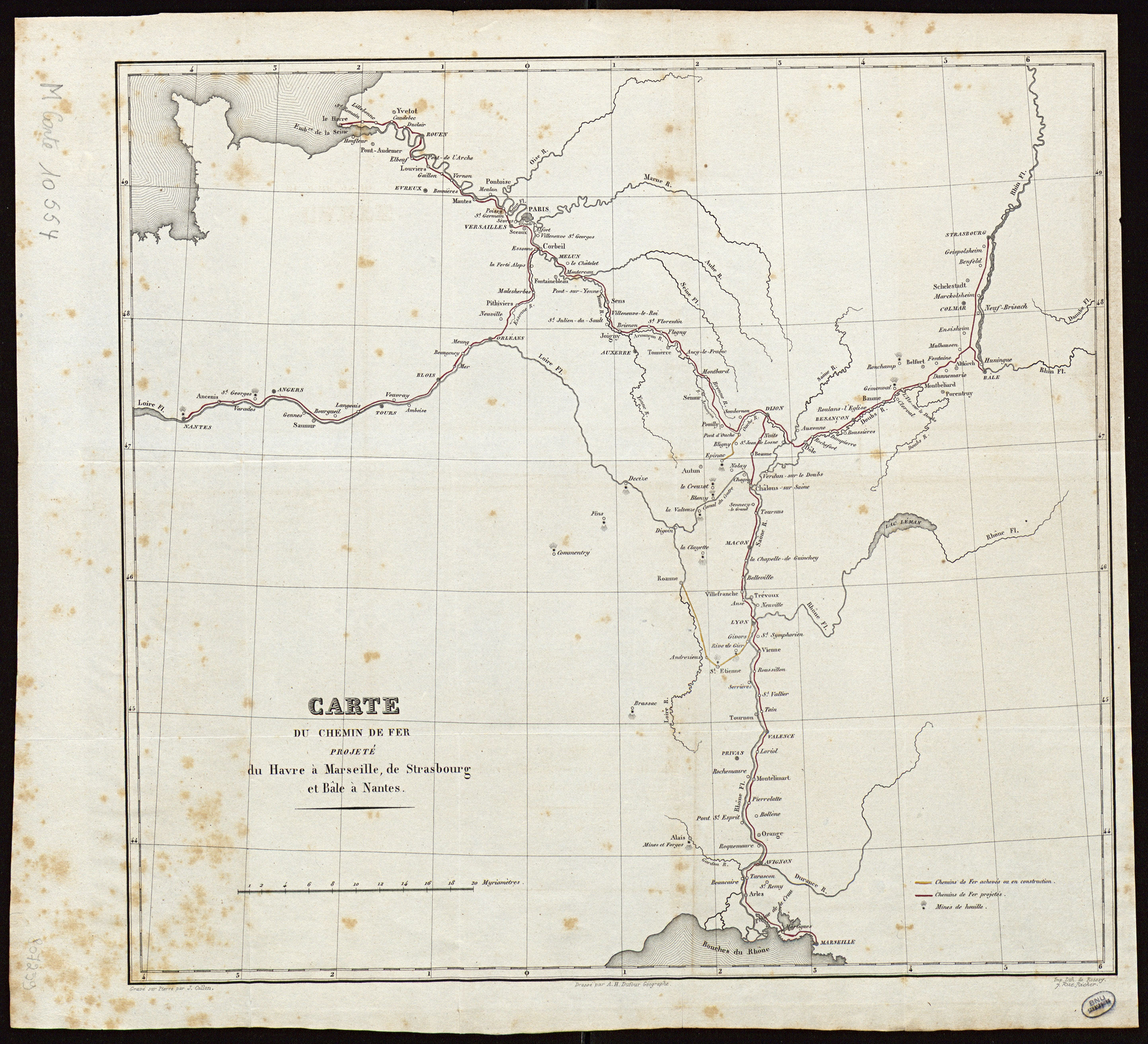
Figure 2. The railway plan of Blum.
Source: Carte du chemin de fer projeté du Havre à Marseille, de Strasbourg et Bâle à Nantes/dressé par A. H. Dufour; gravé sur pierre par J. Collon.
Explaining and defending their project to Vifquain, the engineers Simons and De Ridder (Reference Simons and De Ridder1833b) explicitly referred to another Saint-Simonian design Vues politiques et pratiques sur les travaux publics de France by Clapeyron, Lamé, Eugène Flachat, and Stéphane Flachat (Reference Clapeyron, Lamé, Flachat and Flachat1832) and De Block (Reference De Block2011). Moreover, Charles Rogier, taking the lead in the parliamentary debates about the project, had strong ties with the French utopian movement. In his Essais de politique industrielle, Michel Chevalier highlights the role of Charles Rogier in establishing a material network as a base for both industry and the reconfiguration of the map of Europe (Chevalier 1843). The French Polytechnicien even wrote a letter to Rogier stating that Belgium was at the forefront of materializing the new political economy, formulated by the Saint-Simonians:
The call to the liberal mindset in Belgium is a European event. If it is not a French tribune that sets the trend, it is a tribune where they speak French, and at the gate of France. (Chevalier November 11, 1857, cited in Discailles 1908)
Looking back on his career, Rogier wrote a long letter to Chevalier explicitly admitting the influence of Saint-Simonianism on his policy making and decision making:
I often remember the time when I read you in the Globe. The new and ingenious insights, high and generous reflections that you lavished there, have exercised on the direction of my mind, I think that I already told you, an influence that made itself feel in the direction that I had to impact affairs. It seems that mocking Saint-Simonianism has become en vogue. I would like to know where the reformers of today have sought their ideas and what they have conceived since. For me, I blame the Revolution of 1830 as much as the one of 1848 for having arrested their peaceful development and perhaps delayed for a long time their application of these principles shown to and by Saint-Simon and Fourier, and that the extravagants and comedians have so sadly spoiled and compromised. (Rogier January 22, 1868, cited in Discailles 1908)
Besides explicitly influencing politicians and engineers conceiving the network as an instrument of both territorial transformation and European integration, the French movement could also serve as a lens to understand the myriad of (contested) theories and practices surrounding the project. While many of the nineteenth-century utopian movements problematized the material and social implications of industrialization, Saint-Simonians embraced industrial production. The link between science, technology, industry, and societal progress is the linchpin of Saint-Simoniansm. They considered industrial production as the direct application of technology, which was in its turn an application of science and not as before the result of trial and error (see Picon Reference Harvey2002). Due to the strong, predictable, link between science, technology, and industry, industrialization, and thus societal progress could be carefully planned. The related économie politique nouvelle, which moved from laissez-faire economy to a more planned socioeconomic system with “responsible” roles for government and credit institutions, would assure the careful execution of societal transformation through infrastructure. Society could be thought and run as a machine in which railways took center stage. Whereas most nineteenth-century utopias are generally antiurban, spatially translated by formal, closed, inclusive communities positioned in the countryside, Saint-Simonianism reflected upon larger territorial organization, upon urban and rural interconnections and thus network rationales rather than discrete enclaves. Within this larger organization, railways were perceived as the backbone of urbanization and progress, as the main thoroughfare connecting and collecting material and cultural hubs. Territory and society were thought of in terms of networks instead of borders. In addition, the introduction of the new speed not only enhanced the industrial society in which competence underlie social order instead of birth right, but rails also functioned as the symbol of universal association as it connected different nations and races into one politico-economic space (Høgselius et al. Reference Høgselius, Kaijser and van der Vleuten2015; Picon Reference Harvey2002; Wittman Reference Wittman2010). In most cases, new financial institutions and debt instruments drove these big infrastructural projects spurring industrialization. David Harvey frames these works within the start of capitalism and strategies of dealing with capital surplus (Reference Harvey2000). Other academics perceive Saint-Simonianism as the first step toward the emancipation of the working class as it aimed at educating laborers and rendering them socially mobile as the result of an overall network mobility. Saint-Simonianism thus seems full of ambiguities. Scientific and social innovation are intertwined; as well as science and religion; capitalism and socialism; territory and network; and spaces of place and spaces of flows. Antoine Picon explains that it is precisely this contested modernization, these foundational tensions of the modern world, that are central to the ideas and practices of Saint-Simonians (Picon Reference Harvey2002: 8–9). The Belgian railway network materializes these tensions as it combined national competition and European integration; defining national borders and stimulating international exchange; and bolstering political revolution and universal association (see figure 3).
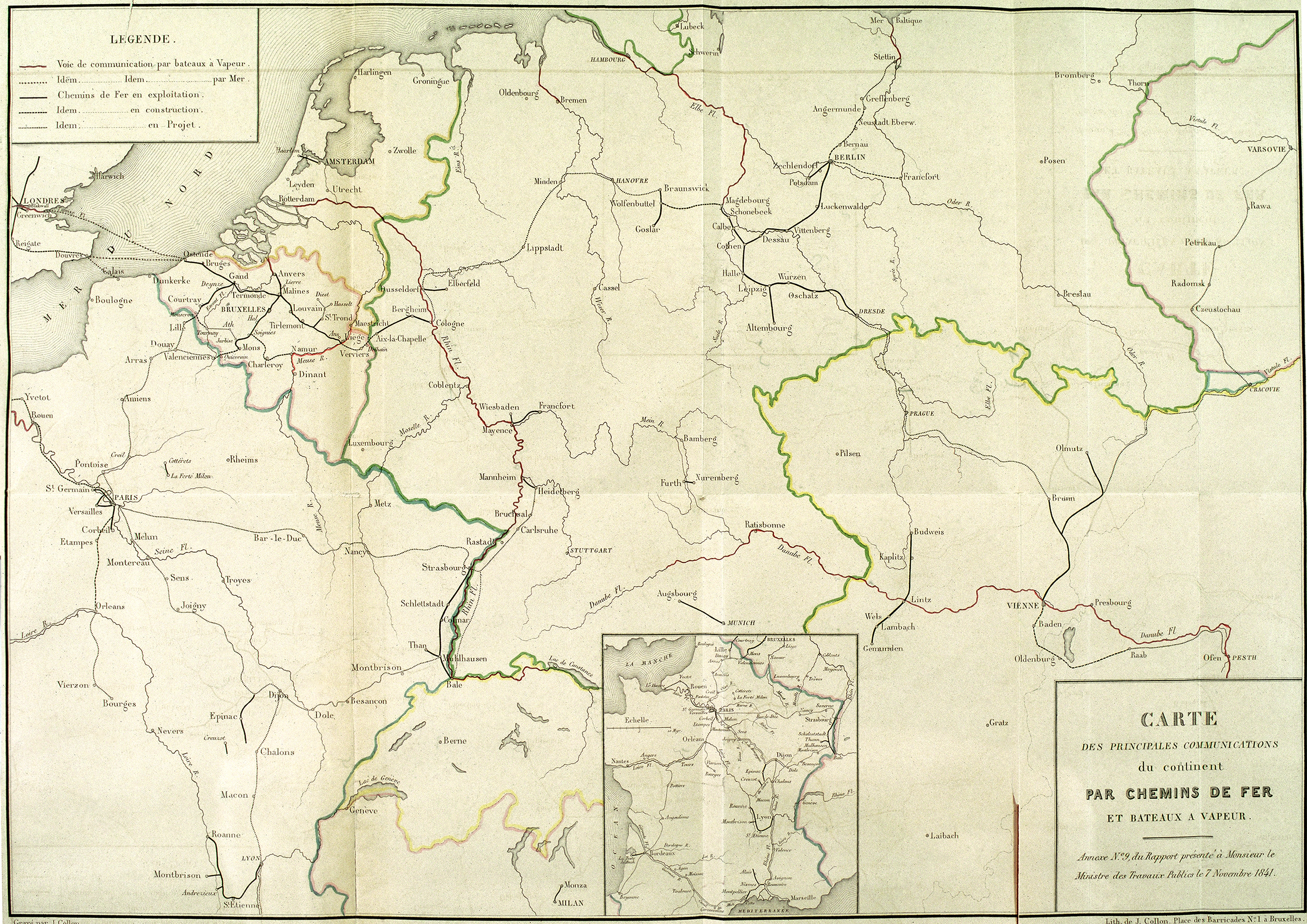
Figure 3. Plan of 1841 showing the materialized Belgian railway network, as the first in Europe. The network is conceived as a crossroads at the center of both Belgium and Europe.
Source: Carte de principales communications du continent par chemins de fer et bateaux à vapeur (November 7, 1841).
Governing “Uncultivated” Land and People: Regional Networks
The same ambiguities and contested modernization can be found in the second public works initiative directed toward the peripheral regions of Campine (Limburg – province located north-east) and Luxembourg (province located south-east), based on plans of engineers Kümmer and De Puydt, respectively. Parallel with the debates about the railway network, and the choice for an iron trajectory through the center of the nation, projects for waterways and roads connecting the peripheries of the Campine and Luxemburg were initiated by King Leopold I (1835) as well as engineer De Puydt (Reference De Puydt1834). The King’s call for research exploring the cultivation of “unproductive” land resulted mainly in infrastructure projects for the Campine region, assembled and synthesized by Kümmer. De Puydt was more concerned with Luxemburg and its poor road network.
De Puydt’s Quest for Regional Balance
During the parliamentary debates about the railway, De Puydt proposed a loan of 16 million francs to construct roads (March 6, 1834). During the railway debates, De Puydt repeatedly intervened in the Chamber of Representatives forwarding roads as the base of the national infrastructure network. According to him, roads engendered agriculture and small industries, which incrementally would scale up and agglomerate, to be eventually connected to waterways and railways needing larger quantities of goods (De Puydt March 6, 1834). As such, he presented the exact opposite rationale to network design than the one proposed by the railway engineers. The network should start from, and be initiated by, the locality, which should be supported by government funding allocated to the provinces with the lowest density of infrastructure (and industry). This strategy would stimulate endogenous growth of mainly agricultural enterprises, which he considered to be the base of industry as it literally would feed the growing industrial society. In addition, allocating funds to the least connected areas would uplift the “unproductive” regions of Luxemburg and Limburg (ibid.). While Simons and De Ridder based their rationale on the highest traffic flows and industry, De Puydt listed the density of the road network in the different Belgian provinces with the aim to select the least connected for funding to increase regional balance (see figure 4). The growth of road density would cause an increase of flow and industry, instead of the other way around.

Figure 4. Table published by De Puydt (March 6, 1834) showing the regional unbalanced road network.
Source: De Puydt (Reference De Puydt1834), Développemens(sic) de la propositions de M. R. De Puydt relative à un emprunt de 16 millions pour être affectés à la construction de routes (documents parlementaires, March 6, 1834).
Due to the focus on the railway as well as Charles Rogier’s efforts to convince Parliament of the gravitational top-down network logic of Simons and De Ridder prioritizing industrial regions, De Puydt’s proposition for regional balance was pushed to the margin. However, two years later, after Parliament had voted for the railway proposal, De Puydt formulated a new request (De Puydt February 18, 1836). This time he asked for only 6 million and explicitly prioritized Luxemburg. Parliament granted the funds, leading to an isotropic road network in the region, aiming to give equal access to the different towns and villages (see figure 5).
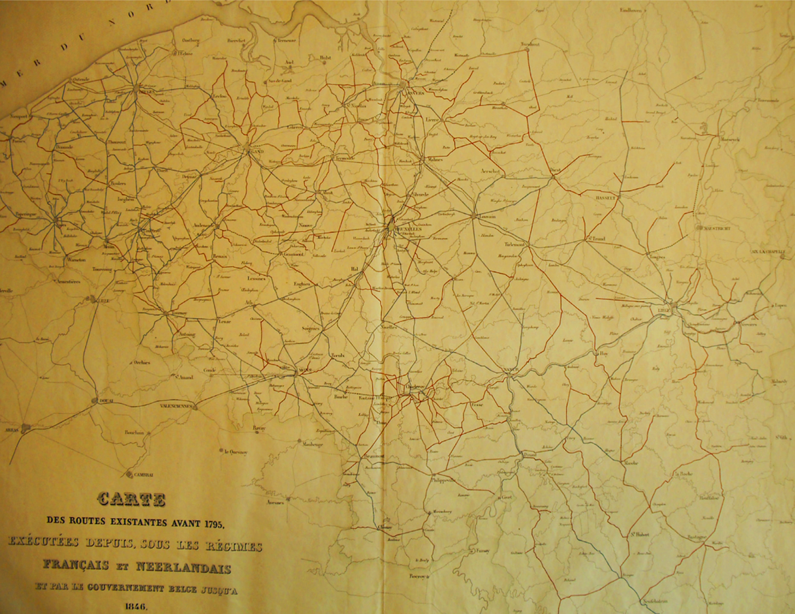
Figure 5. The road network of Belgium in 1846 showing the roads constructed by the French and Dutch regimes and the roads constructed after 1830 by the government (red), demonstrating the implemented program of De Puydt in Luxemburg (South-East corner of the map).
Source: Carte des routes existantes avant 1795, exécutées depuis, sous les regimes français et néerlandais et par le gouvernement belge jusqu’à 1846 (KBR, archive Vandermaelen).
Kümmer’s Land Reclamation Projects
The “unproductive state” of the land in the Campine region as well as in Luxemburg was considered to be the result of two factors: bad infrastructure connections and “inefficient” use of common land (Delacroix Reference Delacroix1860). Dealing with the infrastructure side, engineer Kümmer published Défrichement des bruyères de la Campine: mémoire sur l’intervention projetée du gouvernement (1845), in which he assembled all plans and projects for the Campine region made by his predecessors as well as his synthesis and approved project of 1842. He proposed a system of canals in order, on the one hand, to bring water to “barren” land and turn it into productive agricultural terrain and, on the other, to accommodate transport within and through the region. In addition to this sociospatial motive, also military strategies determined the canal structure. Besides running through heathland that needed to be included into the national production system, the canals formed a physical defense as they ran parallel with the border of the then “hostile” Netherlands. Spurred by the agricultural crisis and increasing poverty in Flanders in combination with growing industrial population and the coal industries’ need for wood, both the northern and central branches were finished in only three years’ time (Van Acker Reference Van Acker2014).
The crisis and side-effects of industrialization also urged the government to deliberate on the second part of the project: the privatization and development of the commons. In 1843, Belgian cabinet leader Nothomb put the question of “how” to cultivate common land to the communes and provinces as well as to agricultural commissions and experts. Besides listing the “unproductive” surfaces that had to be turned into productive agricultural acres—with the Campine (Limburg and Antwerp: 123, 438 ha) and Luxemburg (138, 070 ha) representing a third of all communal land in Belgium—Prime Minister Nothomb underlined the social importance of cultivating this land:
And wouldn’t it be a boon for the workers’ population if the inactive arms could be used for the colonization of heaths and guided in these works by a wise and foresighted administration? (Nothomb September 23, 1843)
Especially the impoverished farmers of Flanders were targeted for both digging the canals as well as populating the new agricultural lands (Kümmer 1851). Engineer Kümmer was again charged with synthesizing the result of the questionnaire, concluding that the government should provide a system of irrigation canals, connected to the Campine canals, to turn soil into fertile land before selling. The national reclamation law of 1847 was based on this study of Kümmer focusing mostly on the Campine (Anonymous 1848). Luxemburg was left out of the deliberations underlying the national law, leading to critiques about both the infrastructural works and the societal project driving them. After all, Luxemburg already had an extensive and sophisticated irrigation system in place, explained De Puydt (Frère-Orban February 9, 1847: 733). Moreover, the representative of Luxemburg voted against privatization of commons and argued for dividing the commons and distributing them amongst the population (Kümmer Reference Kümmer1845). The idea behind the law of distributing welfare and buffering poverty on a national level was contradicted by the local sociospatial mechanism of the commons providing a last resource, according the Minister of Public Works Frère-Orban:
The communal land is always there, as a last resort for the less fortunate. (February 5, 1847: 760)
Spurred by a combined agricultural crisis of failed harvests (1846–48) and demise of cottage industry (see Vanhaute Reference Vanhaute2011), Charles Rogier, like most of the government, considered the commons, not as a local buffer, but as a national buffer for food production as well as for poverty. In a letter to the governors of Antwerp, Limbourg, Liège and Namur, he underlined this motive:
I believe, Mr. Governor, that it is urgent to call the attention of the communal authorities to this point, informing them that I am disposed to advance funds to all those who, having land suitable for clearing, would like for their part, to make some sacrifices to employ in the necessary works for this purpose the less fortunate people who appear on the lists of charity and who live partly of alms. (Ministère de l’intérieur 1850: 23)
Notwithstanding the opposing voices from Luxemburg, there was an overall consensus about the combined action of irrigation and the expropriation of common land. Before enacting the law, the government decided to start with a test project developing 122ha of heathland in Neerpelt/Overpelt (Delacroix Reference Delacroix1860) (see figure 6). After the irrigation works, a public sale of the land resulted in a net profit of five times the initial value (Tilborghs Reference Tilborghs1987), a surplus mechanism leading to the fast adoption of the national reclamation law on March 25, 1847.
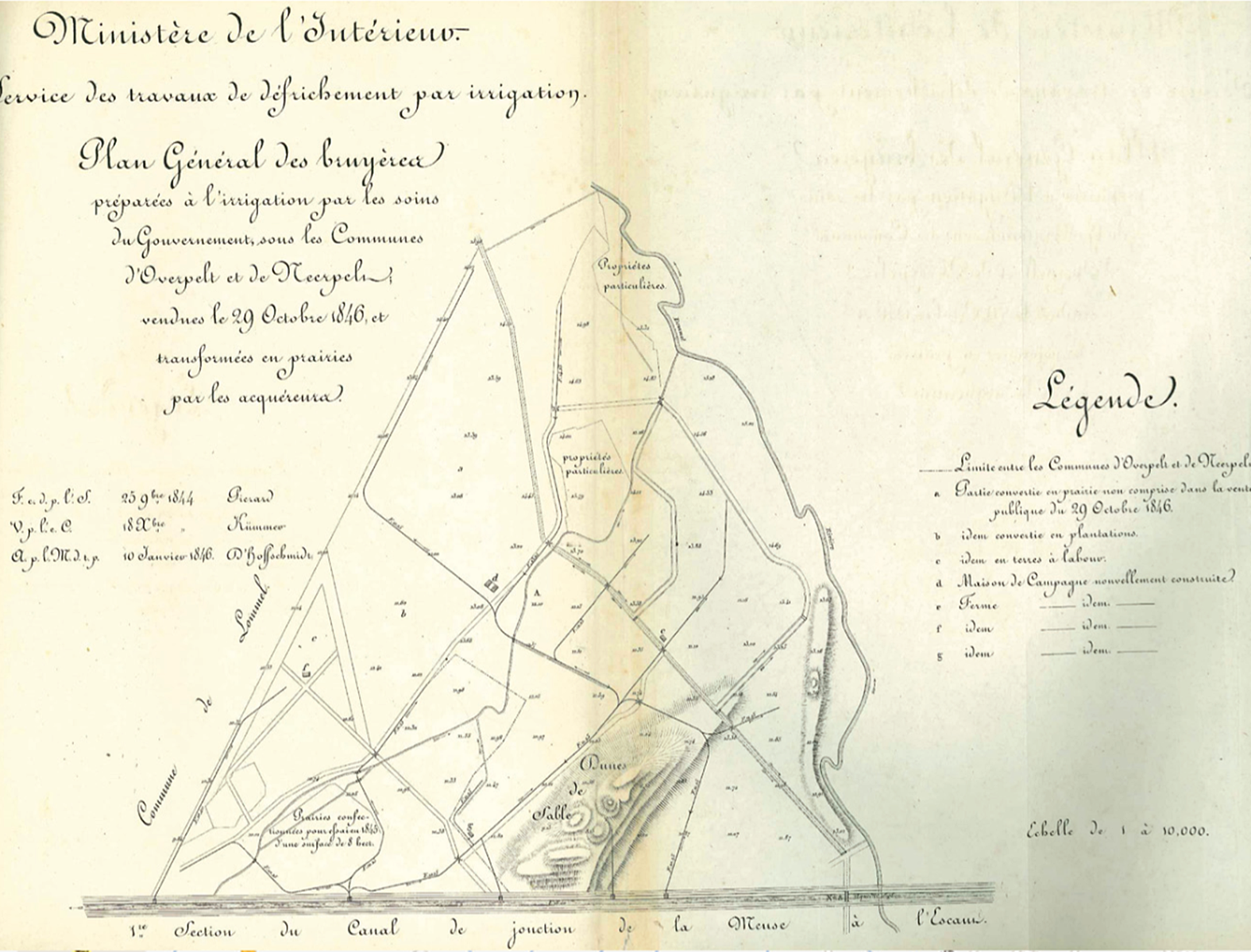
Figure 6. The test project in Neerpelt/Overpelt connecting a system of irrigation canals to the Campine canal.
Source: Ministère de l’intérieur (1850), Défrichement des terrains incultes. Exécution de la loi du 25 mars 1847. Annexe n°8. (Brussels, Devroye).
In line with the irrigation scheme for the test project, Kümmer drew a series of irrigation schemes for the Campine, of which many were executed. Moreover, on request of Charles Rogier, he designed an agricultural colony, which explicitly translated the infrastructure-urbanization mechanism that was implicitly inscribed in all irrigation schemes (see figure 7). Despite earlier failed attempts to set up agricultural colonies, Charles Rogier was convinced that with modern agricultural techniques the colonies would be successful in efficiently producing crops as well as reducing poverty in Flanders. As Kümmer wrote: “[W]e must include, preferably, as tenants, small, intelligent farmers from Flanders” (Kümmer 1851: 40–41). In a publication summarizing the results from 1847 to 1849, Kümmer was even more explicit. His Rapport adressé à M. le Ministre de l’Intérieur, par l’ingénieur Kümmer, sur les résultats obtenus à la suite de l’intervention de l’Etat, pour la création de prairies irrigables dans la Campine, pendant les années 1847 à 1849 inclusivement, included the chapter “Construction de chapelles et d’écoles, destinées à provoquer l’établissement de nouveaux centres de population, en Campine”:
Our previous reports … had as objectives various considerations as to the means to employ, to accelerate, as much as possible, the work of fertilizing the soil of the Campine. These reports also dealt with the correlation between these means and the possibility of not only giving work to the needy working class of other localities in the country, but also of seeking to attract some of the surplus of the population of Flanders. (Kümmer 1850)
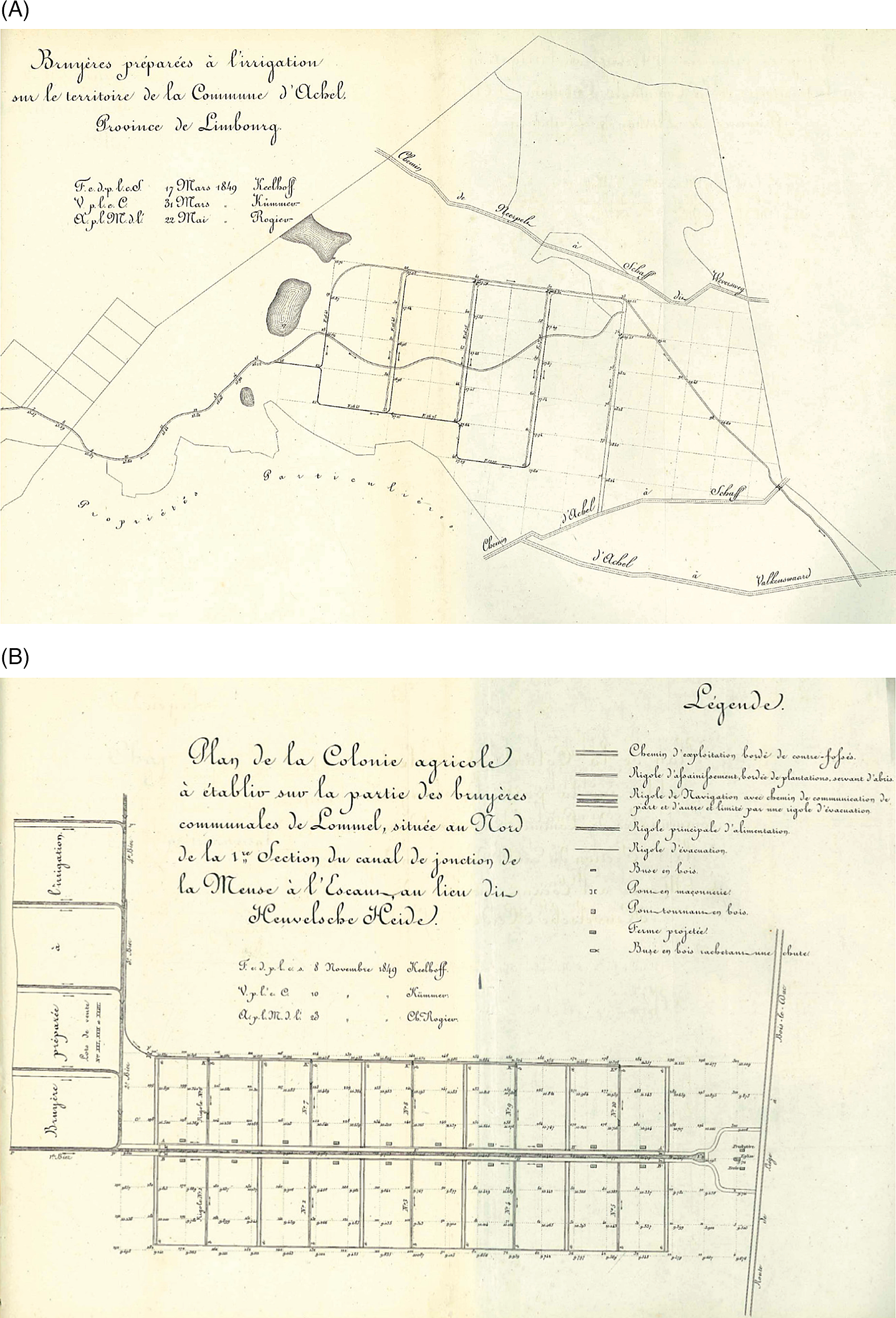
Figure 7. A (left): example of irrigation scheme without explicit urbanization scheme. B (right): the agricultural colony with farms, school, and church.
Source: Ministère de l’intérieur (1850), Défrichement des terrains incultes. Exécution de la loi du 25 mars 1847. Annexe n°8. (Brussels, Devroye).
Besides farms, also a school and church were included in the grid structure for the agricultural colony in Lommel. Infrastructure was again the backbone of territorial transformation, which in turn had to generate socioeconomic development.
Conclusion: The Material Politics of Infrastructure Networks
In the time span of two decades, state engineers, in close collaboration with policy makers, designed a territory-covering public infrastructure network consisting of rails, roads, and water. A central railway cross connected all industrialized regions with each other and neighboring countries. The railway project connected the ambition of facilitating national industrial progress with positioning Belgium as international crossroads within Europe, thus safeguarding the independence of the new nation of Belgium. The centrally positioned railway was complemented with networks of roads and waterways in the peripheral regions of Limburg and Luxemburg, turning “unproductive” common land into “productive” agricultural terrain feeding the growing industrial population as well as providing work and rehabilitation to the marginalized, and indeed also making them “productive.” Especially the reclamation projects in the Campine, linked to a dense network of waterways and vicinal roads, could be considered as a first effort to develop (or colonize) the countryside as well as to integrate these regions into the national territory and production system. While the railway network rooted the technology of steam in the national territory by predicating its network design on a logic following demand, connecting places in which industrialization was settling, the regional networks of roads and water were driven by a supply logic to “unproductive” places pursuing motives of internal colonization. By means of these different major public works projects, engineers conceived an infrastructure network serving as a backbone for territorial transformation both bolstering growth as well as buffering side-effects and uncertainties, or at least converting these uncertainties into manageable risks, with the construction of agricultural colonies as prime example.
The analysis underwrites Foucault’s thesis that, from the nineteenth century onward, territory was no longer conceived according to a predictable future and a static perception, but was entrusted to the modern engineer whose instruments could incorporate progress as well as associated uncertainties “within a multivalent and transformable framework” (Foucault Reference Foucault2007: 20). Designing “involved not so much establishing limits and frontiers, or fixing locations, as, above all and essentially, making, possible, guaranteeing, and ensuring circulation: the circulation of people, merchandise, air, etcetera,” Foucault summarized in his first lecture on “Security, Territory and Population” at the Collège de France (Foucault Reference Foucault2007: 29). In the nineteenth-century context of accelerating industrialization and urbanization, a sequence of political revolutions, agricultural crisis, and epidemics spreading over large territories, only the combination of scientific knowledge and the ambition to (re)shape the territory embedded within infrastructure design could tackle the problems of causality and circulation characterizing modern society (De Block Reference Divall and Revill2016).
The article demonstrates that the intentional influence of infrastructure network on territorial transformation and modernization cannot only be explained by rhetoric of politicians or even engineers, but must be studied in its particularity and materiality. The research complements social and urban history as well as the history of technology and transport history with an analysis of the material politics of infrastructure network design. By studying the conception of infrastructure network as object of governance simultaneously geared toward internationalization as well as territorial demarcation and organization of the new nation, this essay adds historical-spatial specificity to the relation between territory and network (Agnew Reference Agnew2010). A focus on the materiality, on the design of networks, foregrounds that the layout of infrastructure and the related ideas on territorial transformation often assembled contested ideas on modernization. The railway network was designed to negotiate between European and national integration; between European connectivity and national sovereignty; between “universal association” and national competition; and between strong governmental intervention and laissez-faire. The schemes of roads and waterways for the peripheral regions combined ideas on regional redistribution with internal colonization; privatization of the commons with public schemes for agricultural colonies. In postrevolutionary Belgium, where infrastructure acted as glue around which ideological opposites could assemble and take action, the material politics of infrastructure networks was instrumental in regulating relations between spatial and societal transformation. By analyzing the specific sociospatial ambitions inscribed in the design of infrastructure network, territorial integration acquires a literal material quality that refers back to design negotiations and decisions about infrastructure as intermediary between territorial transformation and ideas about modernization.
Acknowledgments
I am very grateful to my colleagues Henk de Smaele and Maarten Van Ginderachter for sharing their expertise, thoughts, and support. The comments of the referees helped streamlining the paper.


