


The southern Pacific region of Mesoamerica (Figure 1) saw many precocious developments including early rank societies, agricultural intensification, low-relief sculpture, and urbanism (Love Reference Love2007; Rosenswig Reference Rosenswig2010). Inomata and colleagues (Reference Inomata, Ortiz, Arroyo and Robinson2014) proposed in this journal a new dating for the apogee of Kaminaljuyu that would push it 300 years later than has traditionally been assumed. Building on the proposed new chronology, Inomata and Henderson (Reference Inomata and Henderson2016) reconstruct what it would mean to redate the low-relief sculptures found across southern Mesoamerica, shifting them all into the Terminal Formative (aka Protoclassic) period. In this journal, Love (Reference Love2018), with data from El Ujuxte, and Mendelsohn (Reference Mendelsohn2018), with patterns from Terminal Formative Izapa, have also responded. I add my perspective by presenting new data from the Formative-period occupation of Izapa.

Figure 1. Southern Mesoamerica with Middle and Late Formative centers.
Izapa originally garnered attention because of its corpus of carved sculpture (Culebro Reference Culebro1939; Drucker Reference Drucker1948; Stirling Reference Stirling1943). The New World Archaeological Foundation's (NWAF) investigations in the 1960s defined the site's large mounds, recorded the sculpture, and dated both based on ceramic association (Lowe et al. Reference Lowe, Lee and Espinoza1982). The reporting of the mounds at Izapa and of the distribution of sculpture was of high quality for the time (Ekholm Reference Ekholm1969; Lowe et al. Reference Lowe, Lee and Espinoza1982; Norman Reference Norman1973, Reference Norman1976). Over the years, there has been varied iconographic interpretation of the imagery carved into the stone monuments (e.g., Guernsey Reference Guernsey2006; Milbrath Reference Milbrath1979; Quirarte Reference Quirarte1973, Reference Quirarte, Lowe and Pye2007; Smith Reference Smith1984). Lowe and colleagues (Reference Lowe, Lee and Espinoza1982:317) proposed that the subject matter of Izapa stelae was the “glorification of mythical events or ritual cycles, agricultural gods or ‘deity representations,’ and allegorical weather phenomena.” Absent are named rulers, as became the message of most Maya stelae during the Classic period (Guernsey Reference Guernsey2016:340).
I do not engage in this article with the meaning (either to modern peoples or to those long dead) of the carvings on Izapa's sculpture, but assume that stylistically similar sculptures were sponsored by related (culturally and possibly genetically) kings who ruled the polity. I further assume that public sculpture executed in similar styles, but carved at different polities, reflect shared ideals of public discourse and probably shared political institutions. I also take as a given that this public discourse had to do with political/religious authority and that the end result was a justification of the elevated position of powerful people and the maintenance of the political status quo.
We cannot know for certain when an individual sculpture was carved, and careful excavation can only date its final resting place. For Izapa, the final occupation of the site was during the Terminal Classic period, AD 900–1000 (Rosenswig and Mendelsohn Reference Rosenswig and Mendelsohn2016). We know that some Formative-period stelae, altars, and a throne were reset in Group F (see Figure 2) by this time (Lowe et al. Reference Lowe, Lee and Espinoza1982:224–226). Fortunately, for those of us interested in occupation of the site in the Middle and Late Formative periods, later inhabitants of Izapa had reverence for earlier kings and left much of the Formative-period sector of Izapa largely intact. I use the word “largely” because the northern part of the Mound 30 platform was extended during the Itstapa phase and stelae were erected there and at Mound 9 after the Guillén phase (300–100 BC) had ended (Rosenswig et al. Reference Rosenswig, Culleton, Kennett, Lieske, Mendelsohn and Nunez-Cortez2018). Therefore the modern archaeological site of Izapa was dynamically evolving during the Prehispanic era.

Figure 2. Hill-shaded digital elevation model of Izapa based on lidar data collected by the IRSP. Letters are mound groups, and numbers are mound numbers.
Not every center in southern Mesoamerica has so many low-relief sculptures with “Izapa-style” iconography as does Izapa. There are no low-relief stelae at El Ujuxte, and Kaminaljuyu has few such sculptures, such as Stelae 8, 10, 11, and 19 and Monument 65. Takalik Abaj also has a few sculptures, such as Stelae 1 and 4; Chocolá (Kaplan Reference Kaplan2008) and El Jobo (Shook Reference Shook and Willy1965) each have one. In contrast, at Izapa, there are dozens and dozens of carved stelae in this style in various states of disrepair. The most intact were published by Norman (Reference Norman1973, Reference Norman1976) and redrawn by Clark and Moreno (Reference Clark, Moreno, Lowe and Pye2007), with more drawings of the less complete stelae forthcoming. More low-relief stone stelae are likely out there waiting to be discovered. There is also quite possibly an entire universe of painted stone stelae (and maybe painted wood stelae), as well as painted walls, like those at San Bartolo (Saturno et al. Reference Saturno, Stuart and Beltrán2006). Many sites in addition to Izapa could have had a corpus of public art depicted in a variety of such perishable media. Although I certainly would not want to reify the current state of our knowledge, the proposal of a significantly expanded corpus of imagery on wood and plaster is speculative. Even more speculative is the possibility that there were stylistically related representations on paper that could have been transported more easily around Mesoamerica.
Based on our current knowledge, the public art of Izapa defines the artistic conventions of “Izapa-style” stone monuments. Following Guernsey (Reference Guernsey2006:70–73), style refers to the form, elements, qualities, and expressions in art, whereas iconography addresses the subject matter. I employ the term “Izapa style” purposefully in the rest of this article and enclose it in quotation marks for two reasons. First, the quotations emphasize that this style did not necessarily originate in the site of Izapa (Lowe et al. Reference Lowe, Lee and Espinoza1982:23). It could have, but we are unlikely to ever know its origins with certainty. The aesthetic is derivative of earlier public artistic conventions used in the Isthmian region, the history of which is reviewed at length by Guernsey (Reference Guernsey2006:43–73). In particular, the Middle Formative “Olmce style” low-relief monuments found across Chiapas on travel/trade routes (e.g., Pijijiapan, Xoc, La Union, etc.; see Clark and Pye Reference Clark, Pye, Clark and Pye2000) seem a likely source of inspiration. The Chiapas monuments form the central portion of the distribution of carved sculptures that extend from Central Mexico to El Salvador and depict individuals walking, sometimes with a “baby” under one arm, or multiple individuals conversing with each other.
Second, I maintain the site name in defining the style to emphasize that, by sheer numbers, the currently known stylistic (and iconographic) canon is tethered to the site of Izapa. As just noted, a handful of other sites in southern Mesoamerica have a few unmistakably similar monuments. The Izapa kingdom was likely no more powerful than these other polities, but somehow was more prestigious and worthier of emulation (think of French language, chefs, and clothing imported to Russia during the nineteenth century). As Clark and Lowe (Reference Clark, Lowe, Lowe, Ekholm and Clark2013:69) note, “No contemporaneous city had as many stone monuments which displayed such a variety of mythic and narrative scenes.” This means that for scholars today, the canon of publicly depicted imagery at Izapa is the standard to which other sculptures must be compared. That is, certain carved stelae at Takalik Abaj, Kaminaljuyu, or Chocolá can be described as having an “Izapa style.”Footnote 1 The reverse does not hold true: the dozens of sculptures known from Izapa are not evaluated in terms of similarity to those from other sites.
My aim in this article is to contribute to the discussion between Inomata, Love, and Mendelsohn on the archaeological and chronological context of carved monuments in southern Mesoamerica. I do so by better defining the changing size and chronology of the Izapa kingdom's capital city using settlement pattern results and AMS dates from recent work. First, I review this disagreement brewing in the pages of Latin American Antiquity. I then discuss regional settlement survey data that demonstrate that by 700 BC the rulers of the Izapa polity held dominion over a territory measuring at least 450 sq. km in which were located dozens of lower-order monumental centers. It is important to note that Izapa functioned as the capital of a kingdom for centuries before low-relief stone monuments were carved and publicly displayed. Next, I present new data that define the Izapa capital's changing size from the Conchas through the Hato phases (1000 BC–AD 100). These patterns of fluctuations in the city's size are based on surface surveys, are presented in terms of hectares of occupation and number of mounds, and are compared to those based on NWAF excavations (Clark and Lowe Reference Clark, Lowe, Lowe, Ekholm and Clark2013). Then, I review 34 recently published AMS dates that fix the Izapa kingdom in time and define the Guillén phase as dating from 300–100 BC. These new dates and the volcanology of the looming Tacaná volcano (Macías et al. Reference Macías, Arce, Capra, Saucedo and Núñez2018) confirm that some sort of political disturbance occurred at Izapa during the first century BC. A volcanic eruption corresponded to a transformation in the organization of rulership at Izapa between 100 BC–AD 100, during the Hato phase, after which the political epicenter of the site shifted northward to Group F. It is possible that stelae continued to be carved in the “Izapa style” after 100 BC (Mendelsohn Reference Mendelsohn2018:257), but more likely, already carved monuments were repositioned to meet new political agendas (Lowe et al. Reference Lowe, Lee and Espinoza1982:133, 207). In the remainder of this article, I stick close to the data I know best and describe what happened at one Prehispanic kingdom during a little more than a millennium. I do not tell others how to date the deposits, ceramic phases, or stone sculptures at the sites where they work. I do, however, tell them how to date these elements at Izapa.
Recent Opinions on the Temporal Placement of “Izapa-Style” Low-Relief Stelae
Inomata and Colleagues (Reference Inomata, Ortiz, Arroyo and Robinson2014)
After undertaking an extensive review of C14 dates from Kaminaljuyu that included Bayesian statistical manipulation, Inomata and others (Reference Inomata, Ortiz, Arroyo and Robinson2014:392) conclude that the Providencia phase should be moved to the Late Formative period and that therefore the Verbena phase should be bumped to the Terminal Formative (aka Protoclassic) period after 100 BC.Footnote 2 With this proposed temporal revision at Kaminaljuyu in mind, they redate other sites with low-relief sculpture in southern Mesoamerica. After reviewing ceramic descriptions and publishing radiometric evidence from Takalik Abaj, Chalchuapa, Santa Leticia, the Salamá Valley, the Chixoy Valley, and the Grijalva Valley, they conclude that similar changes in dating may also be warranted in all these other areas. They also posit that there “was a Middle Preclassic collapse that occurred at 400 B.C. associated with the La Venta polity dissolving and that the development of political centralization with well-established rulership and stela cult occurred roughly contemporaneously in the Southern Maya Area and in the Maya Lowlands after 100 B.C.” (Inomata et al. Reference Inomata, Ortiz, Arroyo and Robinson2014:402). They seem uncertain, however, about what to do with the three-century-long gap opened up by their proposal, speculating that “the only monuments that seem to date to the 400–100 B.C. span are the so-called ‘potbelly’ statues (Demarest et al. 1982). The rather crude-looking carvings may not have been exclusively tied to centralized power” (Inomata et al. Reference Inomata, Ortiz, Arroyo and Robinson2014:403). These are bold proposals that run counter to conventional wisdom.Footnote 3
The one exception to their purported pattern of temporal realignment is Izapa. They find no indication from their ceramic cross-dating, or Bayesian manipulation of dates published by the NWAF (Lowe et al. Reference Lowe, Lee and Espinoza1982:Table 7.1) that the site's apogee should be shifted later. They conclude that the ceramic “Guillén phase appears to lack clear Protoclassic markers such as nubbin feet, gancho rims and Usulutan vessels” and “the Bayesian model leaves substantial uncertainty with the start date of the Guillén phase range from between 300–100 B.C.” (Inomata et al. Reference Inomata, Ortiz, Arroyo and Robinson2014:399). They continue,
If the traditional placement of the Guillén phase between 300–100 B.C. is correct, Izapa may have been a unique southern center that escaped the political turmoil of that time. This placement may explain its unique ceramic sequence that defies cross-dating with other regions. In this case, bas-relief monuments at Izapa that lacked glyphic texts may represent a bridge between the Olmec-style carvings predating 400 B.C. and the Maya style stelae of Kaminaljuyu, Takalik Abaj, and other southern sites, which we now date to after 100 B.C. [Inomata et al. Reference Inomata, Ortiz, Arroyo and Robinson2014:399].
Inomata and Henderson (Reference Inomata and Henderson2016)
In this article, Inomata and Henderson (Reference Inomata and Henderson2016) propose that all of southern Mesoamerica be reimagined to conform to the revised chronology at Kaminaljuyu. Based on the assumed contemporaneity of all sites with similar style of sculpture, they further propose that the Late Formative low-relief sculptural tradition in southern Mesoamerica, for which the “Izapa-style” figures prominently, be pushed to “c. 100 B.C. or later, not c. 300 B.C. as was traditionally thought” (Inomata and Henderson Reference Inomata and Henderson2016:459). They also propose that the large centers of Kaminaljuyu and El Mirador both “experienced dramatic declines in population and construction around A.D. 150 and stone sculptural production ceased across the entire Maya area” (Inomata and Henderson Reference Inomata and Henderson2016:463; see Love Reference Love2007:298–299). According to their scenario, all of the low-relief stelae must therefore date to between 100 BC and AD 150, which at Izapa is the time designated as the Hato phase. Because Izapa does not fit with their scenario, they assert that “the chronological placement of Izapa's bas-relief sculpture remains under debate” (Inomata and Henderson Reference Inomata and Henderson2016:468). I was surprised to read that such debate existed and intend to put it to rest.
Love (Reference Love2018)
In response, Love (Reference Love2018) asserts that Inomata and colleagues overstated the importance of their revised chronological proposal and provides as evidence his assessment of ceramic artifacts, stratigraphy, and dating at Kaminaljuyu. He cites his earlier article (Love Reference Love2007:292), showing that he has long dated the Arenal phase to 200 BC–AD 100 (which is not that different from Inomata et al.’s [2014] dating of 100 BC–AD 150). He also points out that ceramic phases at Kaminaljuyu are long and vaguely defined, stratigraphic relationships between deposits are ambiguous, and older radiometric dates, especially those from the Penn State project, have both wide error ranges and doubtful phase assignments. These problems with older dating highlight that a lack of dates from superimposed contexts undermines the primary contribution of the Bayes method. As Love (Reference Love2018:263) states,
If stratigraphic context is lacking how does one verify the relationship between two contexts placed in the same phase? The longer the phase, the higher the probability of error, if we consider all such contexts to be contemporary. The need for good stratigraphic controls is especially salient in the Middle to Late Preclassic transition, when the calibration curve plateau produces bimodal probability distributions for most assays.
Love's substantive contribution to the issue is his presentation of 11 AMS dates and two 7-m-deep excavation profiles from within a single elite residence at El Ujuxte. He presents four dates from his Cataluña phase (300–100 BC) and six from his Pitahaya phase (100 BC–AD 100). The Guillén-phase ceramic remains from Izapa are unique and defy direct comparisons (Clark and Lowe Reference Clark, Lowe, Lowe, Ekholm and Clark2013:83–84). Love (Reference Love2018:273) proposes that El Ujuxte, which is located only 34 km from Izapa, “provides a bridge between Izapa and Kaminaljuyu sequences that has eluded previous comparisons.” This is because he claims that both Izapa and Kaminaljuyu ceramic phases can be correlated to his ceramic analysis from El Ujuxte.
If Inomata and Henderson (Reference Inomata and Henderson2016) are correct in their redating of Kaminaljuyu and some other centers, then the glories of the Izapa kingdom were a distant memory alluded to through the use of the “Izapa style” by later peoples. Love (Reference Love2018:273) argues that this supposition revives the “baton theory” of Mesoamerican art that holds that Gulf Coast peoples passed on innovations to Izapa, who in turn passed them on to the Maya (e.g., Coe Reference Coe and Wauchope1965; Norman Reference Norman1973; Quirarte Reference Quirarte, Lowe and Pye2007). In spite of Love's derision, it remains a viable hypothesis that the elites of Izapa could have functioned as a repository for knowledge forgotten elsewhere. In the Old World, scholars of various Moslem societies maintained knowledge and literature of the Classical world for centuries and then reintroduced it to Europe after the Dark Ages.
Mendelsohn (Reference Mendelsohn2018)
In response to Inomata and colleagues’ (Reference Inomata, Ortiz, Arroyo and Robinson2014) temporal reassessment, Mendelsohn (Reference Mendelsohn2018) reports results from her recent excavations at Izapa. Her substantive contributions come from excavations south of the Izapa monumental center (at Mound 255; see Figure 2) that document domestic remains from the Terminal Formative Hato and Itstapa phases, associated ceramic artifacts, and two AMS dates. She cross-dates the ceramic decoration style in the Hato phase at Izapa, which runs from 100 BC–AD 100, with Pitahaya at El Ujuxte and Verbena at Kaminaljuyu based on novel characteristics such as nubbin feet and red-on-orange decoration (Mendelsohn Reference Mendelsohn2018:250–251). Her assessment is consistent with the Guillén phase temporally lining up with the Cataluña phase and the Hato phase with Pitahaya, but differs from Love's (Reference Love2018:237) in terms on how these coastal convergences align with the Arenal phase at Kaminaljuyu. Either way, Mendelsohn's data are incompatible with the proposal that would shift Izapa's Guillén phase and associated low-relief sculpture to after 100 BC.
Regional Kingdom of Izapa
Izapa has become something of a black box because, until recently, little was known of the kingdom beyond what was documented in the early 1960s and preliminarily published in the 1980s (i.e., Lowe et al. Reference Lowe, Lee and Espinoza1982). New NWAF publications increase the available information (Clark and Lee Reference Clark and Lee2013; Lowe et al. Reference Lowe, Ekholm and Clark2013; Navarette Reference Navarette2013). In this section, I discuss my recent efforts to better understand Izapa.
Since 2011, the Izapa Regional Settlement Project (IRSP) has collected almost 600 sq. km of light detection and ranging (lidar) data and documented both regional population trends and the location and internal organization of more than three dozen lower-order political centers from the Middle and Late Formative periods (Rosenswig and López-Torrijos Reference Rosenswig and López-Torrijos2018; Rosenswig et al. Reference Rosenswig, López-Torrijos, Antonelli and Mendelsohn2013, Reference Rosenswig, Mendelsohn, Antonelli, Lieske and Cortés2014, Reference Rosenswig, López-Torrijos and Antonelli2015). The Izapa kingdom's territory is now defined as being bounded by the Cahuacán River to the west and by large centers in the other three directions: the Izapa capital to the north, secondary centers of Las Viudas to the south, and El Sitio and El Jardín to the east (Figure 3). Geographic barriers and population centers therefore provide a defensive perimeter around the kingdom's smaller centers. In the course of documenting so many lower-order centers, a number of consistent architectural features have been identified. These are discussed in more detail by Rosenswig and López-Torrijos (Reference Rosenswig and López-Torrijos2018) and together are referred to as “Izapa-pattern” sites. In each site the largest conical temple mound is located to the north, and at primary, secondary and tertiary centers, this northern mound is on a square platform. South of the platform are two to four plaza groups formed by mounds that align south–southwest to north–northeast, so that the overall orientation of each site is either toward the volcano of Tacaná (as is Izapa), Tajumulco, or points in between: the orientation of all centers is between 18 and 28 degrees east of north. The result is that at all sites in the kingdom—from any of the plazas or mounds to the south—the northern pyramid and the “stage” formed by the main temple and south end of the platform are framed by the two volcanoes that rise dramatically from the Sierra Madre mountain range. At Izapa and all secondary centers, there is also an E-Group that defines the southern end of this architectural alignment.
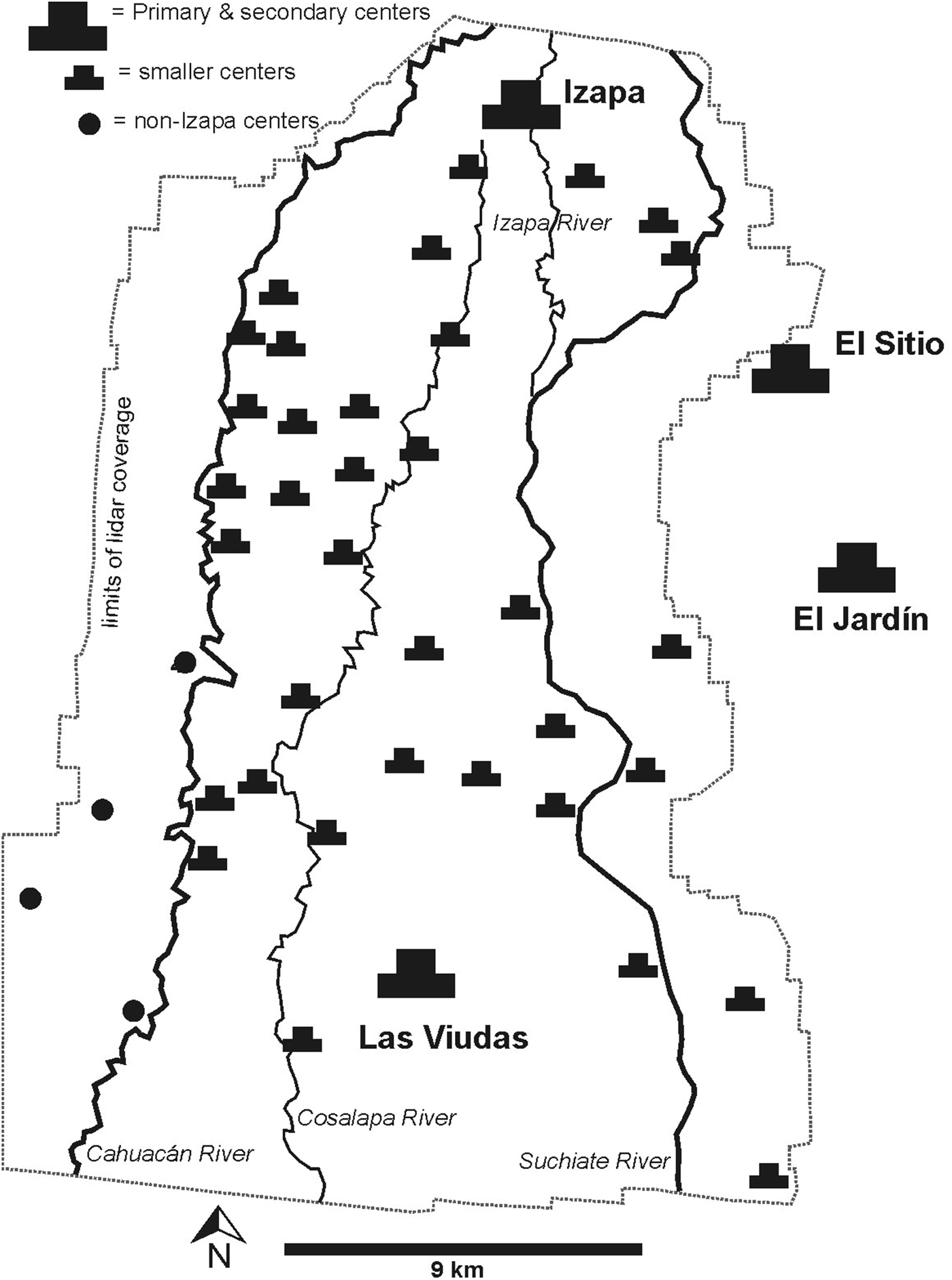
Figure 3. Regional map of the Izapa kingdom (based on Rosenswig and López-Torrijos Reference Rosenswig and López-Torrijos2018:Figure 3).
I assume that the monumental architecture at the center of each site is the locus of routinized ceremonial and ritual behavior and also structures the daily activities of all residents. Furthermore, the similarity of such practices in the centers of the kingdom of Izapa demonstrates a shared set of behaviors and rituals that both created and reflected a shared identity and some degree of cultural affiliation. As discussed in more detail by Rosenswig and López-Torrijos (Reference Rosenswig and López-Torrijos2018), the similarity in architectural form and orientation within the Izapa kingdom is contrasted with the neighboring polities of El Ujuxte and Takalik Abaj, in which different architectural standards reflect different ritual practices and thus different affiliations (Love Reference Love2007:294–295). Within the overall shared structure of kings and elite culture, which defined a shared hierarchical social structure across Pacific Mesoamerica's polities at this time (Love Reference Love, Love and Kaplan2011), individual practices differentiated each kingdom.
To be clear, the site of Izapa does not currently conform to the “Izapa pattern” because it was expanded repeatedly after its initial construction (Figure 2). However, enough excavation has been conducted at the site so that we know it did conform to this pattern during the Middle Formative Escalón and Frontera phases, when Mound 30a defined the northern end of the site and three plaza groups extended southward in Groups B and G (Clark and Lee Reference Clark and Lee2013; Lowe et al. Reference Lowe, Lee and Espinoza1982; Rosenswig et al. Reference Rosenswig, Culleton, Kennett, Lieske, Mendelsohn and Nunez-Cortez2018). During the Guillén phase, Groups A, D, and other plaza groups were built to the west, and additional infilling of mounds during the Itstapa phase contributed to the current form of the site (Lowe et al. Reference Lowe, Lee and Espinoza1982; Rosenswig and Mendelsohn Reference Rosenswig and Mendelsohn2016). The city of Izapa was not static urban space: the kingdom emerged and grew, and the capital evolved over many centuries. During the Guillén phase it distinguished itself from other large centers in the kingdom both by building more plaza groups west of the original alignment and lining them with low-relief stone sculptures.
It is now clear that a regional polity was established by 700 BC with Izapa as its capital and dozens of other monumental centers as administrative nodes. Redating Izapa's Guillén phase and the associated low-relief sculptures to after 100 BC would open up a coordinated, centuries-long hiatus in occupation throughout the Izapa territory. More than 40 sites with monumental architecture have Escalón, Frontera, and Guillén phase ceramic remains scattered on their surfaces. So, if the Guillén phase is misdated, that would mean all of the 40 sites were occupied for four centuries, abandoned at 300 BC, and then all reoccupied for another few centuries after 100 BC. Based on the regional data, Occam's Razor alone would eliminate this redating scenario from serious consideration for the Izapa polity.
The Izapa Capital
The archaeological site of Izapa is located on the edge of a low piedmont below the Sierra Madre of Chiapas, Mexico. The arrangement of Izapa's mounds and its sculpture were carefully documented and reported by the NWAF (Lowe et al. Reference Lowe, Lee and Espinoza1982:inset). Izapa's architecture was later remapped using lidar technology that revealed previously unrecognized features and determined the site's boundaries for the first time. Newly identified architectural features include formal plazas along the Izapa River and an E-Group at the site's southern end (Rosenswig et al. Reference Rosenswig, López-Torrijos, Antonelli and Mendelsohn2013). Excavation data from Izapa indicate that Groups B and G were established in their current arrangement during the Escalón and Frontera phases (Lowe et al. Reference Lowe, Lee and Espinoza1982, Reference Lowe, Ekholm and Clark2013; Rosenswig et al. Reference Rosenswig, Culleton, Kennett, Lieske, Mendelsohn and Nunez-Cortez2018). Mound construction was subsequently extended to the west, and Groups A, D, and H were built during the following Guillén phase (300–100 BC).
A pedestrian survey undertaken by the IRSP documented the Izapa site's occupation on a phase-by-phase basis (Figure 4). These surface results show very minor occupation during the Conchas phase and relatively little during the Hato phase. From Duende through the Guillén phase, the occupation at Izapa was centered around lower Izapa (i.e., the large mounds, plazas, and sculptures located south of the modern highway; Figure 2). Surface collections provide scant evidence of occupation during the Conchas phase (1000–800 BC), when the only remains we encountered on the surface were from three mounds in Groups B and G. These hints of early occupation are located precisely where the original architecture was built during the following Duende phase: such scant Conchas-phase remains, located only at what was to be the site center, is consistent with excavation data (Clark and Lowe Reference Clark, Lowe, Lowe, Ekholm and Clark2013: Figure 37). During the Hato phase (100 BC–AD 100), there is more evidence of occupation, but all remains were documented north and west of the Formative-period site center (see Figure 4). The results from these two phases bracket the extensive occupation of lower Izapa documented during the Duende through Guillén phases (800–100 BC). Using the same methodology of pedestrian ground-truthing, surface collection, and subsequent analysis of ceramic artifacts, these data provide a consistent, quantitative basis from which to infer the changing size of the Formative-period capital city of the Izapa kingdom.
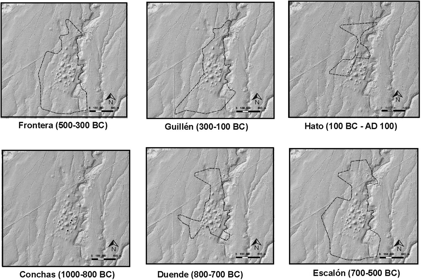
Figure 4. Documented extents of occupation in the Izapa capital from the Conchas through the Hato phases.
It was during the Duende phase that mounds were first built at Izapa: our results are consistent with NWAF excavations that document that Mound 30a was built up to 10 m above the platform during this time (Lowe et al. Reference Lowe, Lee and Espinoza1982). Mound 30a defined the northern end of Group B as the original center of the site with the “Izapa pattern.” During the Escalón phase (700–500 BC) the Izapa site's occupation reached its largest size, with evidence documented over 229 ha (Figure 5). Using population estimates of 25 people/ha, this would represent a city with 5,725 inhabitants (Rosenswig and López-Torrijos Reference Rosenswig and López-Torrijos2018). One hectare is about the size of two American football fields or one rugby field. So, 25 people living in such an area represents low-density urbanism, with plenty of space to grow crops within city limits. In the following Frontera and Guillén phases there is evidence of fewer hectares (189 and 156 ha, respectively) over which remains were documented. The central core of the site (i.e., Groups B and G) was occupied during the Escalón, Frontera, and Guillén phases, as was a large area south of Group G (see Figure 4). The number of hectares of occupation decreased from the Escalón to the two later phases because only a smaller area north of the modern highway and west of the monumental core of lower Izapa was occupied. The 33 ha decrease from Frontera to Guillén times was from the area immediately west of Groups A and D and occurred precisely when the mounds that defined these plazas were constructed. Therefore, the new north–south rows of plazas (Groups A and D) were built west of the traditional site center (Groups B and G), and at the same time, people living in small mounds on the west side of these new plaza groups were relocated. Nevertheless it is unclear if the smaller number of hectares reflects fewer people living at the site: the total area of occupation does not necessarily reflect the total number of people living in the city because the population density can change. If density increased during the Guillén phase, the overall population of the Izapa capital could have remained unchanged.

Figure 5. Hectares of occupation in the Izapa capital from the Duende through the Hato phases.
The total area of occupation is not the only way to document changing population. Figure 6 compares hectares over which surface evidence was spread to the number of mounds that were documented by the IRSP to have ceramic remains from that phase. Both proxies indicate similar patterns of relatively low population during the Duende phase, followed by a significant increase in Escalón times when the regional kingdom was first established. Then, a smaller area and fewer mounds documented in the Frontera and Guillén phases were followed by a significant drop in both proxies during the Hato phase. Each method of population estimation has inherent biases of preservation and detectability. Therefore, when the two proxies correspond, this adds confidence that the patterns do in fact reflect a real past phenomenon (e.g., Palmisano et al. Reference Palmisano, Bevan and Shennan2017). Clark and Lowe (Reference Clark, Lowe, Lowe, Ekholm and Clark2013:69–87) report the area over which sherds were documented in NWAF excavations: these data provide yet another proxy that can be used to estimate relative population size and distribution at Izapa. They report on the Barra through Escalón phases, of which only the last three (Conchas, Duende, and Escalón) overlap with the time period of interest here. Very few Conchas-phase remains are identified, with more from the Duende phase and then considerably more occupation during the Escalón phase (Clark and Lowe Reference Clark, Lowe, Lowe, Ekholm and Clark2013: Figure 38, 39). Thus, a third proxy measure of relative population, based on NWAF excavations, is also consistent with the two produced by the IRSP.

Figure 6. Comparison of the hectares and number of mounds occupied in the Izapa capital from the Duende through the Hato phases.
Based on IRSP results, occupation of Izapa decreased to an area measuring 48 ha during the Hato phase. This is one-third the size of occupation during the previous Guillén phase and one-fifth the size during the Escalón phase (Figure 5). If the same estimate of 25 people/ha is used, the Hato-phase population of Izapa would have been ~1,200 people. The distribution of these hectares during the Hato phase is also informative. The southern region of the site, which had been the main residential location since Conchas times, was no longer occupied (see Figure 4). In fact, IRSP survey data found no Hato-phase ceramic remains in the areas where population had previously been documented south of the site core, as well as in the entire monumental center of lower Izapa. These surface data also document that the zone west of Groups A and D was reoccupied after not being occupied during the Guillén phase. Something (or someone) was no longer prohibiting occupation west of Groups A and D, as had been the case during the Guillén phase.
What caused the Hato-phase changes? An eruption of the Tacaná volcano during the Hato phase brought the Mixcun lava flow to within 7 km of Izapa (Macías et al. Reference Macías, Espíndola, García-Palomo, Scott, Hughes and Mora2000, Reference Macías, Arce, Capra, Saucedo and Núñez2018). Lahars associated with this lava may have also brought pyroclastic flows of hot, muddy water that could have been 6 m high as they coursed through the city (Macías et al. Reference Macías, Arce, Capra, Saucedo and Núñez2018). Such a natural disaster would have shaken the population's confidence in whoever ruled Izapa at the time, especially because the capital was oriented toward this volcano (Blake et al. Reference Blake, Rosenswig and Waber2015). Although the specific political changes will never be known, the construction of monumental architecture ceased, overall occupation levels fell, and the location in which these people lived also changed during the Hato phase.Footnote 4
Regional settlement patterns document contemporaneous disruptions that occurred throughout the Izapa kingdom during the first century BC. During the Hato phase, there was a significant drop in overall population in both the piedmont and low-hill zones of the IRSP survey (Rosenswig and Mendelsohn Reference Rosenswig and Mendelsohn2016:Figure 5). In the Mazatán zone, located 40 km to the northwest, there was a proliferation of sites during the Hato and Itstapa phases, without a single site documented from preceding Guillén times. The earlier absence of occupation in the Mazatán zone indicates that Izapa had exerted significant influence by inhibiting centers from developing (Clark and Lowe Reference Clark, Lowe, Lowe, Ekholm and Clark2013:84–85). Therefore, the disruption to the Izapa kingdom after 100 BC was as dramatic regionally as in the capital city.
Dating Izapa's Sculpture
Izapa's low-relief sculptures were erected in association with Guillén-phase ceramics that date them (Clark and Lowe Reference Clark, Lowe, Lowe, Ekholm and Clark2013:76–77; Lowe et al. Reference Lowe, Lee and Espinoza1982:23–27, 133). Group B had a long history of occupation, but the soils under Groups A and D were scraped clean when the plazas were laid out, the mounds built, and the stelae erected during the Guillén phase. The rapid construction of these plaza groups and the erection of stelae at ~300 BC, followed by the political disruptions due to the eruption of Tacaná in the final decades BC, tightly bracket the erection of Izapa's low-relief stelae. Characteristics of Guillén-phase ceramics have recently been described in detail (Lowe et al. Reference Lowe, Ekholm and Clark2013). Inomata and colleagues (Reference Inomata, Ortiz, Arroyo and Robinson2014) argue that, based on their reassessment of radiocarbon dates, low-relief sculpture across southern Mesoamerica might all be dated to after 100 BC. In the case of Izapa, this would mean either that the Guillén phase is misdated or that the NWAF was wrong in its assessment of the association of these ceramics with the erection of low-relief stone sculptures.
Guillén Ceramics
Guillén-phase ceramics are distinctive from those produced during the preceding Frontera phase and so are simple to identify. Tuzantan is the most common type of decorated ware and has a soft orange slip that frequently flakes off to reveal a white underslip and a dark core. These characteristics are evident in Figure 7 (color online). All of these slip and paste characteristics are different from the preceding Mundet Red type of the Frontera phase (Figure 8) that have darker and redder slips that are very well adhered and do not have dark cores. Both types share the distinctive form of very wide, everted rims with pre-slip grooves on flat-bottom serving dishes (compare Figure 8 and the five sherds in the top right-hand corner of Figure 7). The form of Tuzantan serving dishes is clearly derivative of those of the preceding Mundet type, but due to the difference in color and adherence of the slip, they can be easily distinguished by archaeologists, even when recovered from surface contexts on survey.

Figure 7. Guillén-phase Tuzantan rim sherds from Izapa.

Figure 8. Frontera-phase Mundet Red serving dish with a wide everted rim.
Guillén-phase ceramics are also distinctive from those produced during the following Hato phase. Hato-phase ceramic characteristics, such as bichrome decoration, nubbin supports, and the lack of wide everted rims, make assemblages from this phase easy to distinguish from the Guillén phase in both excavated and survey contexts. Furthermore, the lack of Usulután stripped resist decoration in the Guillén phase and its presence during the Hato phase are other clear ways to distinguish between ceramics from the two phases (Lowe et al. Reference Lowe, Lee and Espinoza1982:139). I assume Lowe and others at the NWAF could identify Guillén-phase ceramics, distinguish them from Frontera and Hato types, and correctly interpret the associated ceramics and stratigraphy associated with low-relief sculptures. Therefore, the only possible problem in dating the Guillén phase and associated low-relief sculptures at Izapa would have to lie with the radiometric dates themselves.
Radiocarbon Dates
The original radiocarbon assays run by the NWAF (Lowe et al. Reference Lowe, Lee and Espinoza1982:Figure 7.1) date the Middle and Late Formative Frontera and Guillén phases, as well as the Terminal Formative Hato and Itstapa phases. These dates and the ceramic cross-ties were used to establish the NWAF chronology. As was common with traditional radiocarbon dates established in the 1970s, the NWAF results have large error ranges. Such error ranges of 90 to 200 years (Table 1) result in 2-sigma ranges of 360 to 800 years and are not particularly helpful when determining 200-year-long ceramic phases. However, 34 new dates have been run in the twenty-first century that support the NWAF chronology (Table 1). These new assays confirm both the rise and fall of Izapa, with its architectural and sculptural apogee during the Guillén phase from 300–100 BC. New AMS dates published by Rosenswig and colleagues (Reference Rosenswig and López-Torrijos2018:Tables 2 and 3, Figure 7) support those previously published by the NWAF, and stratigraphic association demonstrates that the Escalón, Frontera, and Guillén phases follow each other between 700 and 100 BC. Mendelsohn (Reference Mendelsohn2018:Table 2) provides one new AMS date from a Hato-phase domestic context and another one from an Itstapa-phase context.
Table 1. Radiocarbon Dates Relevant to the late Middle through Terminal Formative Period Chronology of Izapa.

New AMS assays from the estuary between the Izapa kingdom and the Pacific Ocean date specialized salt production facilities. Neff and colleagues (Reference Neff, Burger, Culleton, Kennett and Jones2018:Table 8) present 15 new AMS dates from the estuary relevant to the segment of the Izapa chronology discussed here. Eight of these dates confirm the Burmudez complex, when the highest level of occupation is documented in the estuary, between 450–0 BC (roughly the Frontera and Guillén phases) when Izapa was at the peak of its power.Footnote 5 An additional seven AMS assays date the Soledad complex, to when the lowest level of occupation is documented in the estuary, between AD 0–250 (roughly the Hato and Itstapa phases). There were 75% fewer Soledad age mounds documented in the estuary (Neff et al. Reference Neff, Burger, Culleton, Kennett and Jones2018:Figure 7) when Izapa was also experiencing population loss and political disruption after the eruption of Tacaná (see Figures 4–6 and Rosenswig and Mendelsohn Reference Rosenswig and Mendelsohn2016:Figure 5a). These estuary patterns reflect regional adaptation, and most significantly, these patterns are well dated (if at a coarser temporal resolution) and independently derived. The number of salt production facilities in the estuary reflects the rise and fall of urban dwellers in Izapa and lower-order centers within the kingdom who were dependent on maize as a staple crop. Guernsey (Reference Guernsey2016:345–349) also infers referents to salt production in Izapa monuments’ iconography of canoes that she associates with the sal cocida process.
The final source of new radiometric dates comes from geologic investigations that reconstruct eruptions of the Tacaná volcano. Macías and colleagues (Reference Macías, Arce, Capra, Saucedo and Núñez2018:Table 1) have seven AMS dates that place the eruption between 30 BC and AD 80, indicating that this natural disaster followed the Guillén phase. The eruption is therefore placed in the Hato phase and corresponds to significant decreases in population in Izapa city (Figures 4 and 5), in the estuary located some 40 km away (Neff et al. Reference Neff, Burger, Culleton, Kennett and Jones2018), and from the intervening occupation of the kingdom documented in the IRSP low hills and piedmont zone (Rosenswig and Mendelsohn Reference Rosenswig and Mendelsohn2016:Figure 5). The dates published by Macías and colleagues (Reference Macías, Arce, Capra, Saucedo and Núñez2018) do not directly place archaeological deposits in time, but they do date the volcanic eruption that clearly affected the entire Izapa polity.
If we add Lowe and others’ (Reference Lowe, Lee and Espinoza1982) dozen radiometric results, then there are 46 dates to anchor the ceramic and stratigraphic evidence of the Escalón through Itstapa phases. One can always call for more dating, but the dates presented in Table 1 provide a solid foundation on which to build a chronology.
Discussion
Inomata and Henderson (Reference Inomata and Henderson2016) propose that all low-relief carved sculpture in southern Mesoamerica should be dated to 100 BC–AD 150. As we have seen, this was not the case for those at Izapa. They also assert, “Stylistic comparisons with securely dated murals from the Preclassic Maya lowlands (Saturno et al. Reference Saturno, Stuart and Beltrán2006) lend further support to this argument” (Inomata and Henderson Reference Inomata and Henderson2016:459). A problem with this statement is that, according to the excavators, the San Bartolo murals and painted glyphs date to 300–200 BC (Saturno et al. Reference Saturno, Stuart and Beltrán2006): the first half of the Guillén phase at Izapa. Therefore, the San Bartolo murals refute rather than support the proposal that the redating of Kaminaljuyu be applied across the entire Maya area. Further, those working at some of the largest early cities in the Petén date the beginning of the political apogee of sites like El Mirador and Cival to 300 BC (Estrada-Belli Reference Estrada-Belli2011; Hansen Reference Hansen, Boxt and Dillon2012). Izapa, San Bartolo, El Mirador, and Cival all have public art executed in related styles. Single glyphs like those painted on the San Bartolo murals and the six known to be carved into stone monuments at Izapa (see Mora-Marin Reference Mora-Marín2018) resemble each other because they are bar-and-dot numerals that name individuals with calendar names. The Late Formative period is also when El Palenque emerged as the center of a state in the Valley of Oaxaca during the Monte Albán I phase (300–100 BC) before being conquered by the expansionist Monte Albán during the Terminal Formative Monte Albán II phase (100 BC–AD 200; Redmond and Spencer Reference Redmond and Spencer2017). The danzantes at Monte Albán also have isolated glyphs that presumably name individuals, just like at Izapa and San Bartolo. If Inomata and colleagues’ Reference Inomata, Ortiz, Arroyo and Robinson2014 redating of Kaminaljuyu is correct (and I think it likely is), this pushes that site's apogee a few centuries forward. However, chronological refinement at this site does not mean that a realignment is required for all sites with low-relief stelae.
Some southern Mesoamerican centers have dated monuments that are consistent with Inomata and his colleagues’ (Reference Inomata, Ortiz, Arroyo and Robinson2014) proposal. For example, Takalik Abaj Stela 5, with its dates of AD 80 and AD 126, and Stela 2, with its dating between 39–19 BC, are consistent with their revised chronology. Erection of low-relief monuments evidently continued at some sites and was likely to occur when the elites who commissioned them reached their greatest power. This may well have happened at Kaminaljuyu and Takalik Abaj, but not at Izapa. I do not see any a priori reason why it is problematic for different sites to have had different cycles of waxing and waning of their political power.
Conclusion
There is no reason to assume that cultural change in Mesoamerica occurred in a coordinated or simultaneous manner. The timing of the Izapa kingdom's political fortunes could have been out of step with those of nearby polities. There were no detectable negative impacts at Izapa when the La Venta polity collapsed around 400 BC. It was during the Frontera phase (500–300 BC) that Izapa's principal temple pyramid (Mound 30a) reached its full height of 16 m above the underlying platform. All of the kingdom's 40 (or more) monumental centers, first established during the Escalón phase, continued to thrive and persisted into the following Guillén phase (Rosenswig and López-Torrijos Reference Rosenswig and López-Torrijos2018). If anything, the collapse of La Venta resulted in increased elaboration of the ritual (and probably political) power of Izapa's elite. At some point in the fourth or early in the third century BC, public monuments in the round were replaced by low-relief, narrative-style stelae paired with altars for which the site is (and was) renowned. This was also when the Izapa capital expanded to the west as more plazas were built in which to display these new “Izapa-style” stelae.
The Izapa capital's elite experienced problems a few centuries later when the Tacaná volcano erupted during the Hato phase (100 BC–AD 100) and the core of the monumental center was no longer occupied (Figure 4). Other kingdoms in southern Mesoamerica, like El Ujuxte, Kaminaljuyu, and Takalik Abaj, reached their political apogees at precisely this time (Inomata et al. Reference Inomata, Ortiz, Arroyo and Robinson2014; Love Reference Love, Love and Kaplan2011). The eruption of Tacaná around the beginning of the Common Era was a localized phenomenon with dramatic results only for the Izapa kingdom. It is quite possible that Izapa's troubles in the final century BC benefited the El Ujuxte and Takalik Abaj kingdoms. The political fortunes of these rival kingdoms did not all rise and fall together—and why would they have?
The Izapa elite seems to have reinvented themselves during the Itstapa and Jaritas phases (AD 100–400) when they built a new monumental core for their capital around Mound 125, north of the traditional center (Figure 2). During these early centuries of the first millennium AD, the regional population also rebounded (Rosenswig and Mendelsohn Reference Rosenswig and Mendelsohn2016:Figure 5), and architectural alterations were undertaken at lower Izapa (Rosenswig et al. Reference Rosenswig, Culleton, Kennett, Lieske, Mendelsohn and Nunez-Cortez2018). The two centuries from AD 200–400 was a time of collapse elsewhere in southern Mesoamerica (Inomata et al. Reference Inomata, Ortiz, Arroyo and Robinson2014; Love Reference Love2007). Izapa again seems to have been out of synch with political developments in the region, and the kingdom's rulers charted their own distinct path yet again. Volatile fortunes of individual polities and political jockeying are precisely what is recorded for kingdoms with historical records like the Classic period Maya, ancient Greece, and medieval Europe (Hansen Reference Hansen2000; Nichols and Charlton Reference Nichols and Charlton1997). Environmental deterioration and epidemic disease could have negatively affected all polities in a region at the same time. Nevertheless, the normal operation of a system of competing kingdoms sees one rise, others fall, and then rise again as they compete with each other and aspire to dominate their neighbors. Coordinated political fortunes and the simultaneous adoption of sculptural styles are theoretically unrealistic and seem to have been empirically untrue in southern Mesoamerica during the Middle, Late, and Terminal Formative eras.
Acknowledgements
Lidar data were collected and settlement survey conducted with funding from the National Science Foundation (BCS-0947787 and BCS-1418988), as well as the UAlbany Center for Social and Demographic Analysis, funded by NICHD (R24 HD044943) and a UAlbany FRAP-A award. Fieldwork was undertaken with a series of permits issued by INAH's Consejo de Arqueología. Four field seasons of survey and excavation were undertaken under permits C.A.400-36/2046, 401.C(4)108.2012/DCICH-606, and 401.B(4)19.2015/36/0369. Ricardo López-Torrijos assisted with the processing and analysis of all lidar data collected by the IRSP. Yahaira Núñez Cortés translated the abstract into Spanish. Hector Neff shared unpublished details of his AMS dates with me. John Clark, Rebecca Mendelsohn, and three LAQ reviewers all contributed to improving the final version of this article.
Data Availability Statement
Data may be made available on request.
Supplemental Materials
For supplementary material accompanying this article, visit https://doi.org/10.1017/laq.2018.83
Supplemental Text: Bayesian statistics and radiometric dates that are not stratigraphically associated.


