INTRODUCTION AND AIMS
The radiocarbon (14C) age of soil organic carbon (SOC) pool is subjected to many processes directing the vertical and horizontal pattern of carbon in the soil and exchange between soil and biosphere (Wiaux et al. Reference Wiaux, Vanclooster, Cornelis and Van Oost2014; Doetterl et al. Reference Doetterl, Berhe, Nadeu, Wang, Sommer and Fiener2016). Various sources of carbon can modify the ratio of modern and older C in the composition of SOC (Hales et al. Reference Hales, Scharer and Wooten2012). An increasing age of SOC that parallels increasing distance from the soil surface is expected, since most sources of SOC come from litter and biomass production over the soil surface. However, modern C in the form of dissolved organic carbon (DOC) can infiltrate into deeper horizons (Doetterl et al. Reference Doetterl, Berhe, Nadeu, Wang, Sommer and Fiener2016) in flat areas where infiltration and lessivage is present. This process is less relevant on slopes, where percolation is limited due surface runoff, and in this case it is more likely that soil material redistribution due to lateral translocations will affect the measured age of SOC (Doetterl et al. Reference Doetterl, Berhe, Nadeu, Wang, Sommer and Fiener2016). Mixing of undecomposed plant remnants by bioturbation, the contribution to SOC of deeply penetrating roots and other subsurface bioproduction (e.g. fungi, bacteria) can also rejuvenate the SOC pool, and shift the measurable 14C age of the soil much younger than the time of soil development (Miao et al. Reference Miao, Wang, Hanson, Mason and Liu2016). Where colluvial processes (Zádorová et al. Reference Zádorová, Penížek, Vašát, Žížala, Chuman and Vaněk2015), accelerated erosion (Szalai et al. Reference Szalai, Szabó, Kovács, Mészáros, Albert, Centeri, Szabó, Madarász, Zacháry and Jakab2016) or other slope processes not only move the plant remnants and litter, but also SOC-rich soil material moves downslope, the older SOC pool which had earlier accumulated at depth will come closer to the surface. This results in shifting the 14C age to older values than would be expected in a level position. However, where the litter and eroded SOC can accumulate, SOC age will be modified as well. In the case of heavy material movement from deeper soil horizons, older SOC material will be deposited and will increase the age of the SOC pool. If only undecomposed organic material (litter, branches, mulch) are deposited, then at the place of deposition the 14C age will be shifted to be younger ages (Hales et al. Reference Hales, Scharer and Wooten2012). Burial of well-developed, organic-rich soils due to reduced physical exposure and mineralization (Caopricha and Marín-Spiotta Reference Caopricha and Marín-Spiotta2014; Kirkels et al. Reference Kirkels, Cammeraat and Kuhn2014) can preserve the carbon composition and age signal of its development, which then should indicate the time before burial by younger deposits.
In addition to using direct indication of soil cover transformation (Świtoniak Reference Świtoniak2014; Świtoniak et al. Reference Świtoniak, Mroczek and Bednarek2016) and evaluation of remote sensed data (Bertalan et al. Reference Bertalan, Túri and Szabó2016), we assume that 14C measurements can contribute in substance to reconstruct the erosion events (Li et al. Reference Li, Burr, Löwemark and Ku2017; Nearing et al. Reference Nearing, Xie, Liu and Ye2017) of a hummocky surface, where slope processes are dominant factors in soil development and organic matter redistribution. However, we note that human influence can have a considerable impact on the soil profile. One of the aims of our study was to determine the extent of this impact. Due to the lack of direct erosion measurements for the area, there was no possibility to estimate erosion rates, which is considerable rather episodic, and not consistent. The aim of this study was to date deposits using 14C data and estimate in an indirect way the volume and time of erosion episodes and their relation to human activities.
STUDY SITE
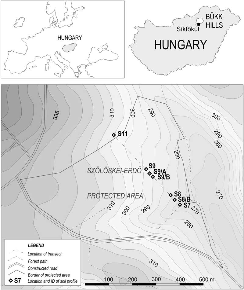
The study area of Síkfőkút is in the hummocky Bükk-foothill region (Northern Hungary) 47°55′N; 20°26′E, a protected oak (Quercetum petraeae-cerris) forest reserve (Szőlőskei-erdő protected area), where there has been no forest management since 1976. At this time the age of the forest was considered to be about 90–100 yr (Stefanovits Reference Stefanovits1985). According to the general trends of the surrounding area, agricultural land use was previously more extensive and intense (Sütő et al. Reference Sütő, Dobány, Novák, Incze, Adorján and Rózsa2017), but very detailed land use history data are not available for the site. The climate is moderately wet continental with dry summers. The annual mean temperature is 10.0–10.5°C and the average annual precipitation 553 mm (Antal and Justyák Reference Antal and Justyák1995). The surface consists predominantly of weathering products of unconsolidated Paleogene marine sediments and Miocene acid volcanoclastic deposits (Gyalog Reference Gyalog2005), and the recent surface development is directed by erosional, derasional, and colluvial processes (Dobos Reference Dobos2012). Forest-ecological characteristics of the site have been studied in detail (Antal and Justyák Reference Antal and Justyák1995; Varga et al. Reference Varga Cs, Kotroczó, Krakomperger and Vincze2008; Fekete et al. Reference Fekete, Lajtha, Kotroczó, Várbíró, Varga, Tóth, Demeter, Veperdi and Berki2017; Tóth et al. Reference Tóth, Nagy, Krakomperger, Veres, Kotroczó, Kincses, Fekete, Papp, Mészáros and Oláh2013), but pedological study of the site has been restricted to generalized characterization of soil conditions (Stefanovits Reference Stefanovits1985).
METHODS
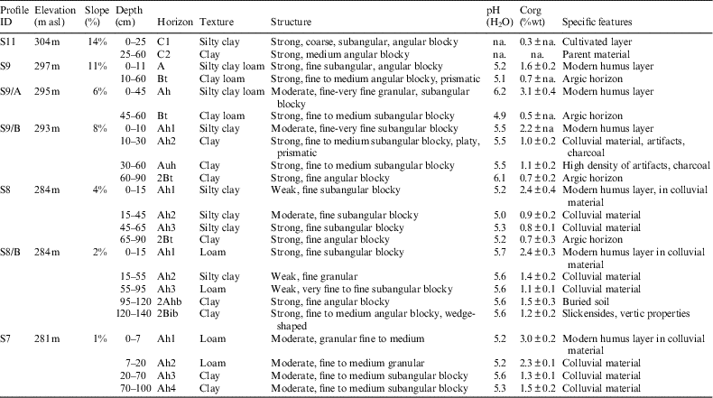
Three middleslope position (S9; S9/A; S9/B) and three downslope position (S7; S8; S8/B) soil profiles were established along a section (Figure 1) crossing an inactive erosional-derasional valley to identify and localize erosion and accumulation features in soils. Sites with only erosional characteristics could not be included into the sequence, being used as cultivated vineyards, where all of the better-developed (an SOC containing) horizons are completely removed by erosion and the small amount of SOC did not allow 14C dating. Soil profiles were described in the field and classified according the guidelines of the World Reference Base for Soil Resources (FAO 2006; IUSS Working Group 2015). From each horizon, soil samples, artifacts, and charcoal pieces, if present, were collected separately. A detailed micro-geomorphological and soil survey was carried out in order to reconstruct the surface development and to estimate their relevance in soil development (Świtoniak et al. Reference Świtoniak, Charzyński, Novák, Zalewska and Bednarek2014; Botos et al. Reference Botos, Boda, Márta and Novák2015).

Figure 1 Location of the study site.
Soil samples for general analysis were dried at 40°C for 72 hr and homogenized. Texture was determined according the grain-size distribution, based on analyses made by the sieve and pipette method (Pansu and Gatheyrou Reference Pansu and Gatheyrou2006). Organic C content was measured by wet oxidation using the bichromate method (Ponomareva and Plotnikova Reference Ponomareva and Plotnikova1980), pH was measured in 1:2.5 H2O using a standard glass electrode, and inorganic carbonate content was measured by a Scheibler calcimeter (Chaney et al. Reference Chaney, Slonim and Slonim1982).
Two profiles, one on the midslope (S9/B) with obviously eroded, truncated character but clearly visible human impacts in the form of soil disturbances and a high concentration of charcoal and artifacts, and another one on the downslope (S8/B) consisting of deep colluvial deposits over an older buried soil at a depth of 95–120 cm were chosen for 14C AMS analysis. Charcoal pieces and artifacts collected from both of these and from further profiles (S7, S8) were also included in the evaluation of age data.
For 14C AMS analysis samples from charcoal and brick as well as bulk soil samples were pretreated in the HEKAL AMS laboratory (Molnar et al. 2013a). Inorganic carbonates in soil samples and bricks were removed by 1N HCl at 75°C, for at least 2 hr. Charcoal fragments were separated visually under an optical microscope and treated using the standard acid-base-acid (ABA) method, i.e. in a sequence of 1N HCl, distilled water, 1M NaOH, distilled water, and then 1N HCl HCl at 75°C, for 1–2 hr each step (Molnár et al. Reference Molnár, Janovics, Major, Orsovszki, Gönczi, Veres, Leonard, Castle, Lange, Wacker, Hajdas and Jull2013a). After the final acid wash, the sample was washed again with distilled water to neutral pH and freeze-dried. For all types of sample materials, a two-step method (charcoal, soil and brick) was applied: first at low temperature combustion (400°C, “LT” fraction) and afterward on the same sample at high temperature combustion (800°C, “HT” fraction) in the presence of high-purity oxygen gas in a quartz tube (Jull et al. Reference Jull, Burr, Beck, Hodgins, Biddulph, Gann, Hatheway, Lange and Lifton2006; Molnar et al. 2013a). The resulting CO2 gas was then collected and purified separately to form LT- and HT-fractions using an on-line combustion system line and later converted to graphite using the sealed tube Zn-graphitization method (Rinyu et al. Reference Rinyu, Orsovszki, Futó, Veres and Molnar2015).
All 14C measurements were done on the graphitized samples using a compact 14C AMS system (EnvironMICADAS) developed by ETH Zürich (Synal et al. Reference Synal, Stocker and Suter2007; Wacker et al. Reference Wacker, Bonani, Friedrich, Hajdas, Kromer, Némec, Ruff, Suter, Synal and Vockenhuber2010), which has been operating at the Hertelendi Laboratory of Environmental Studies since 2011 (Molnár et al. Reference Molnár, Rinyu, Veres, Seiler, Wacker and Synal2013b).
IAEA–C9 (fossil wood) standards were treated and measured in parallel to the samples to check the quality of the preparation. NIST SRM 4990C standard and borehole CO2 samples were used for normalization of the MICADAS. The results were corrected with the decay of the standard and δ13C isotopic fractionation. We used the “BATS” software (Wacker et al. Reference Wacker, Bonani, Friedrich, Hajdas, Kromer, Némec, Ruff, Suter, Synal and Vockenhuber2010) for data reduction of the measured values.
Conventional 14C ages were converted to calendar ages using Calib 7.0.4 software (Stuiver and Reimer Reference Stuiver and Reimer1993) and the IntCal13 calibration curve (Reimer et al. Reference Reimer, Bard, Bayliss, Beck, Blackwell, Bronk Ramsey, Buck, Cheng, Edwards, Friedrich, Grootes, Guil- derson, Haflidason, Hajdas, Hatté, Heaton, Hoffmann, Hogg, Hughen, Kaiser, Kromer, Manning, Niu, Reimer, Richards, Scott, Southon, Staff, Turney and van der Plicht2013). Calibrated ages are reported as age ranges at the 2-sigma confidence level (95.4%).
The high concentration of C in bulk soil also allowed the 14C dating of SOC and timing of human influence for most profiles. The aim of the 14C dating was to distinguish vertical SOC-age patterns of midslope and downslope (accumulation) profiles and to identify the time of erosion events and human influences.
RESULTS
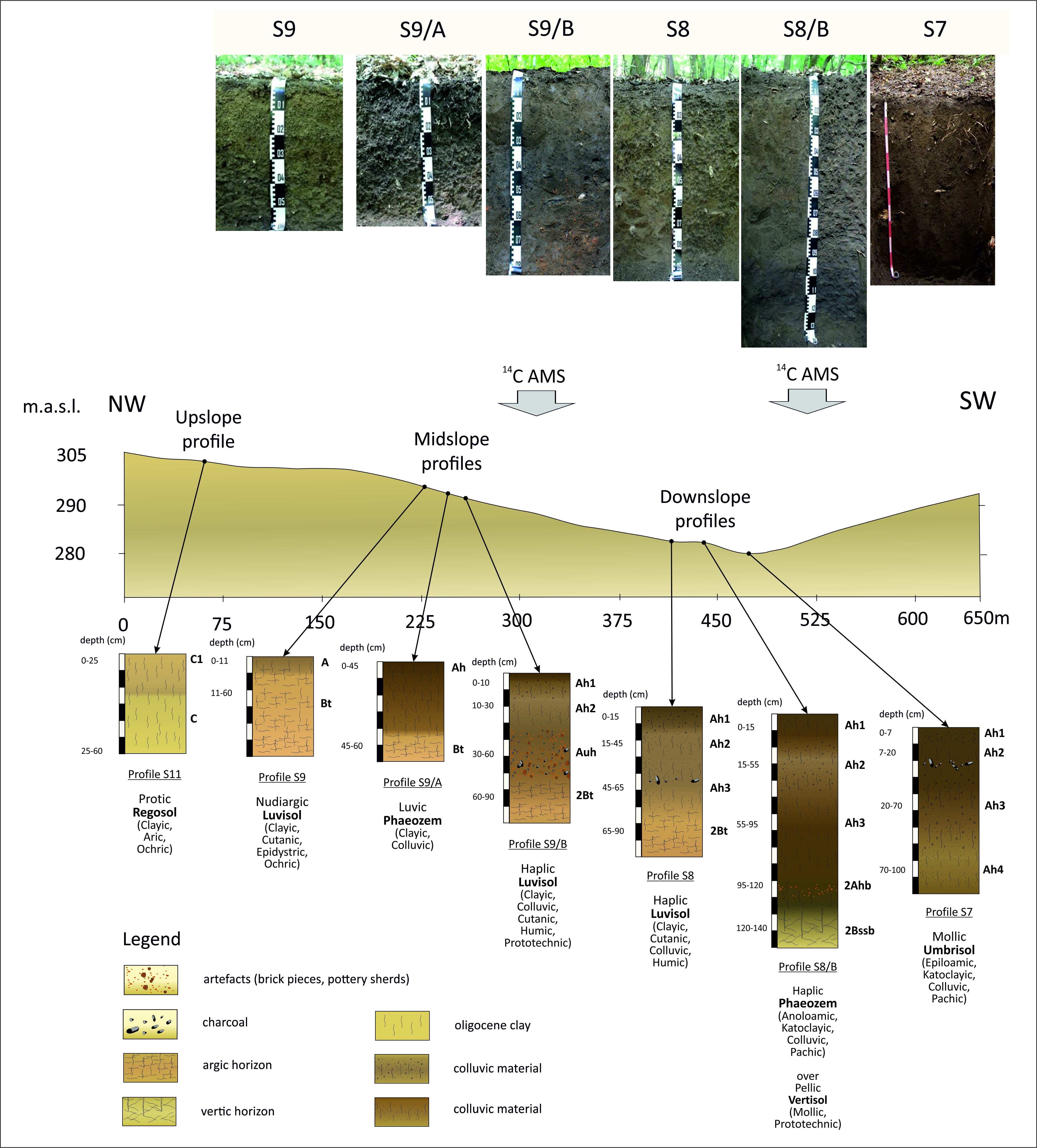
The upslope profile (S11), located outside of the forest in a cultivated vineyard, was completely eroded without recognizable horizon development (Protic Regosol) and a low amount of soil organic carbon. For the middleslope position soil profiles (S9; S9/A; S9/B), which are exposed to erosion, a repetitive pattern of parallel-tended low ridges was discovered along the slope at 4–5 m distance, dissected by shallow ditches, with 10–40 cm depth. The soil profiles showed therefore high spatial variability related with these surface micro-forms. In most typical positions, Luvisol (S9/B) was identified, which were significantly eroded by the ridges and covered by later colluvic material located in the shallow ditches. The erosion is shown by truncated argic horizons (S9), which were covered in several cases (S9/B; S9/A) by shallow accumulation of colluvial material, showing alteration of erosion and deposition in space and time over a small scale. Downslope profiles were classified as Luvisol (S8), Phaeozem (S8/B), and Umbrisol (S7). The main pedological characteristics of the profiles are summarized in Table 1 and their topographic positions are indicated in Figure 2.
Figure 2 Topographic position and horizonation of studied soil profiles.
Table 1 Main characteristics of studied soil profiles.
In the case of the middleslope position, anthropogenic influences on the soil profile (S9/B) were observable in the form of layers enriched with artifacts, but the profile and its environment showed truncated horizons, having shallow or missing humus layers at the surface. The horizons at 30–90 cm showed evidence of a strong human influence including dark color, high density of artifacts and charcoal pieces, ceramics, and a disturbed, highly variable soil structure. This horizon was covered by 30-cm-thick colluvial material. The age of bulk SOC of the topsoil at this location is dated to cal AD 950–1020 (2σ) (at a depth of 10–30 cm). 14C ages of bulk SOC samples, charcoals, and artifacts are listed in Table 2.
Table 2 14C ages of bulk SOC, charcoal and artifact samples and their pedological characteristics.
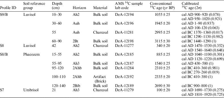
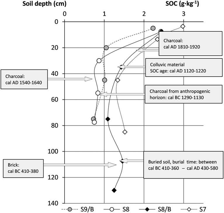
Accordingly, downslope soil profiles (S8; S8/B; S7) showed accumulation of redistributed colluvial material in thicker layers (Figure 2), in the form of organic-rich colluvic material, occasionally containing artifacts, human-transported materials (such as rock fragments not identical with the basal rocks), and charcoal pieces at different depths. The SOC variability with depth is shown in Figure 3. The thicknesses of colluvial layers vary between 65 cm (S8) and 100 cm (S7) depending on slope steepness and topography. In the case of profile (S8/B), a buried soil layer showing Vertisol characteristics (i.e. slickensides, >30% clay content) could be identified, with higher organic content (1.46 g·kg–1) at a depth of 95–120 cm. It indicates balanced antecedent pedogenesis and in situ carbon sequestration until cal BC 410–360 (2σ), before it was covered by the overlaying younger colluvial material (cal AD 430–580 [2σ]).

Figure 3 SOC vertical distribution and identifiable events influencing SOC redistribution in studied profiles.
DISCUSSION AND CONCLUSION
Reconstruction of Site History
Along the studied slope section we found that upslope soil profiles were completely eroded, midslope profiles showed truncated profile horizonation with shallow colluvic accumulations as a result of alternating erosion and accumulation processes, and colluvic accumulations were found in the downslope position. The thickness of colluvial layers, compared to other sites (Zádorová et al. Reference Zádorová, Penížek, Šefrna, Drábek, Mihaljevič, Volf and Chuman2013; Labaz et al. Reference Labaz, Musztyfaga, Waroszewski, Bogacz, Jezierski and Kabala2018) is rather shallow, which could be related to lower intensity and only periodic relevance of human influences in the study site. The otherwise common aeolian silt mantle (Waroszewski et al. Reference Waroszewski, Sprafke, Kabala and Musztyfaga2018) is missing from the studied profiles, and their clay rich texture does not facilitate erosion and colluvial processes as well. Several events affecting the SOC redistribution and surface development processes could be identified based on 14C AMS data (Figure 3). The earliest human impact can be observed due to the high density of charcoal pieces embedded in anthropogenic disturbed soil layers, mixed with artifacts in profile S9/B, and these date to the late Bronze Age, at cal BC 1290–1130 (2σ). Presumably, the site was inhabited and soil profile rework and truncation can be observed, however, burial and conservation of the old charcoal and artifacts in place is not clearly interpretable, since detailed archeological data are not available, and we do not know if they were buried in situ or transported by colluvial processes. However, later deforestation and the steep slope do not allow for thicker accumulation of younger organic material at location S9, therefore the covering soil even close to the surface has SOC with a conventional 14C age of >1000 14C yr.
In the valley bottom profile (S8/B), buried artifacts were found at a depth of 110 cm embedded in a buried soil A horizon. Both SOC of bulk buried soil and some brick fragments indicate burial processes from the Iron Age (cal BC 410–360 [2σ], cal BC 410–380 [2σ] respectively). At a depth of 15–55 cm in the same profile (S8/B), the bulk soil SOC indicates an accelerated redistribution of organic rich material from the Medieval era, dated to cal AD 1120–1220 (2σ). This could be related to increasing intensity of land use at that time within the region, similar to other Central and South Europaean sites (Yoo et al. Reference Yoo, Amundson, Heimsath and Dietrich2006; Dreibrodt et al. Reference Dreibrodt, Nelle, Lütjen, Mitusov, Clausen and Bork2009; Zádorová et al. Reference Zádorová, Penížek, Šefrna, Drábek, Mihaljevič, Volf and Chuman2013).
Charcoal pieces found embedded in colluvial accumulations (S7 and S8) at a depth of 21 and 42 cm depth gave 14C ages of 100±20 BP and 340±20 BP and show that deposition of colluvial material was present even at this time, since the embedding soil SOC has much older age at these depths (885±25 BP and 1055±25 BP, in S9/B and S8/B). Fast deposition of colluvial material between the 15th and 20th centuries may be a result of higher anthropogenic activity (e.g. agriculture) in the study area, as it is typical for the land use history in this region (Sütő et al. Reference Sütő, Dobány, Novák, Incze, Adorján and Rózsa2017).
Depending on the rate of carbon sequestration in soil, including gains from primer production and by SOC redistribution by colluvial processes, the rate of burial by overlying material allowed us to calculate a theoretical ratio between SOC age and soil depth for each soil layer (the conventional 14C age of SOC divided by the distance from the surface in cm; Figure 4). This ratio is similar to more sophisticated age-depth models (Simonneau et al. Reference Simonneau, Doyen, Chapron, Millet, Vannière, Di Giovanni, Bossard, Tachikawa, Bard, Albéric, Desmet, Roux, Lajeunesse, Berger and Arnaud2013; Gierga et al. Reference Gierga, Hajdas, van Raden, Gilli, Wacker, Sturm, Bernasconi and Smittenberg2016), expressing the increase in the apparent age of the SOC with a 1-cm increase in depth. This proved to be different for the middleslope and downslope positions.

Figure 4 Depth-age model of middle-slope and down-slope soil profiles SOC.
Comparing the middleslope S9/B and downslope S8/B profiles, we found that the ages of the carbon pool are increasing with the depth by 48.0 (±6.5) yr · cm–1 and 22.0 (±2.2) yr · cm–1, with considerably different rates (Figure 4). According to our expectations, the middleslope profile shows faster aging of soil C with increasing depth than the down-slope profile, as a result of a smaller gain by lateral flux on the middleslope position, and limited accumulation. Presumably, due to alteration by deforestation and revegetation periods caused by land use changes, the changes in C-gain and C-loss were typical during the investigated time. Nevertheless, the higher standard deviation in the erosion profile indicates that SOC redistribution processes have observable variability over time. In any case, the older 14C age of the deeper SOC pool suggests that the different composition of its organic material can have different contributions (Ellerbrock et al. Reference Ellerbrock, Gerke and Deumlich2016; Premrov et al. Reference Premrov, Cummins and Byrne2017) depending on slope position. Bioturbation can also influence the results of SOC-age models, especially if it has different intensity on middleslope and downslope sites. For the study site there is now information about the relevance of this process, but it is supposed to be less intense than in soils with grassland vegetation and having mollic horizons.
The thicknesses of colluvial layers and their historic triggers proved to be similar to those of other Central European sites (Reiß et al. Reference Reiß, Dreibrodt, Lubos and Bork2009; Dreibrodt et al. Reference Dreibrodt, Lubos, Terhorst, Damm and Bork2010, Reference Dreibrodt, Jarecki, Lubos, Khamnueva, Klamm and Bork2013) but this study was useful for reconstructing the SOC accumulation processes related to land use.
ACKNOWLEDGMENTS
This research was supported by the European Union and the State of Hungary, co-financed by the European Regional Development Fund in the project of GINOP-2.3.2-15-2016-00009 “ICER”.
Supplementary materials
To view supplementary material for this article, please visit https://doi.org/10.1017/RDC.2018.94