


Dominating narratives of the Irish Iron Age has been a group of hilltop enclosures commonly called ‘Royal’ sites. Navan Fort, Tara and Knockaulin, identified in medieval literature as places connected with kingship, inauguration ritual, and assembly, have in excavation and survey produced evidence for prehistoric and, in particular, Iron Age activity. For a long time, however, they stood isolated within an otherwise rather barren Iron Age landscape. This imbalance, in combination with the unusual architecture of the sites and the lasting influence of the medieval narratives, has led to ‘special’ aspects of these sites to be emphasised and models of Iron Age society models to be anchored heavily on them and their interpretation.
PAST PERSPECTIVES
Royal Sites appear in the literature of medieval Ireland as places of kingship, political, and sacral authority. Excavations at Navan (Emain Macha: Lynn Reference Lynn1997a), Knockaulin (Dún Ailinne: Wailes Reference Wailes and Harding1976; Reference Wailes1982; Reference Wailes1990; Johnston & Wailes Reference Johnston and Wailes2007), Tara (Teamhair: Roche Reference Roche2002; Newman Reference Newman2007; Grogan Reference Grogan2008) and geophysical examinations of Rathcroghan (Crúachain: Waddell et al. Reference Waddell, Fenwick and Barton2009) investigated sites that are thought to be the centres of the heroic pagan past described in the medieval literature. However, the idea that these texts provided an historic account of the prehistoric past of these sites started to come under critique in the 1980s as a consequence of the discovery of extraordinarily large and apparently non-domestic structures excavated at Navan and Dún Ailinne (cf. Raftery Reference Raftery1994, 65; Lynn Reference Lynn2006, 11, 13). Also, from a heuristic perspective, the approach represented by Jackson’s (Reference Jackson1964) gaze through the Ulster cycle window into the prehistoric past was critiqued. The problems inherent in using medieval records as a source of information on prehistory were theorised (eg, Aitchison Reference Aitchison1987; Reference Aitchison1994; McCone Reference McCone1990) and underpinned by the identification of the objects and sites described in medieval literature as representing medieval typologies (Mallory Reference Mallory and Scott1980; Reference Mallory and Mallory1992; Reference Mallory2016). The medieval narratives represented in the various different forms of literature that contain references to the country’s pagan past were argued to be constructs of their time, products of political agendas and place making efforts in which prehistoric landscapes, as at Tara, were woven into the construction of ‘prestigious but fictitious genealogies’ (eg, Bradley Reference Bradley1987, 10) in order to legitimise political or social structures (Aitchison Reference Aitchison1987; Reference Aitchison1994). These narratives then reflect contemporary, medieval concerns and concepts (Aitchison Reference Aitchison1994, 42–3) rather than lasting memories of events that happened possibly up to 1000 years before the writing of these texts. Such disassociation of the prehistoric archaeology and medieval text seemed to close Jackson’s window on the Iron Age and there is widespread agreement that these sites were ceremonial, religious sanctuaries, temples, or ritual sites (eg Raftery Reference Raftery1994, 65; Lynn Reference Lynn1997b; Reference Lynn2003b, 106).
The large circular structures at Navan and the figure-of-eight structure at Knockaulin, thought too large for domestic purpose or to have been roofed to provide shelter, have been explored as timber enclosures or arenas with viewing stands (eg Wailes Reference Wailes1990; Lynn Reference Lynn1997b; also Lynn Reference Lynn1991), in the case of Knockaulin’s Mauve phase around an inner sanctum. The extra-ordinary treatment of Navan’s 40 m structure with its apparently pre-planned destruction and monumentalisation by encasement in a large cairn and mound further added to the interpretation of these sites as ritual or ceremonial (Waddell Reference Waddell2014, 22–3). The juxtaposition of these large timber structures with internally ditched enclosures recalled the constellation of features at earlier Neolithic henges and further served to underpin ritual and non-domestic narratives of these sites (eg, Warner Reference Warner2000; Dowling Reference Dowling2006), though the character of rituals as possibly religious, economic, or political in nature has been acknowledged (Raftery Reference Raftery1994, 81–3; Lynn Reference Lynn2006; Johnston Reference Johnston2007b).
KINGSHIP AND COMMUNITY
While critique of the culture-historical models of Celtic society has had impact in so far as an ethnic Celtic model has lost traction for the Irish Iron Age (eg, Raftery Reference Raftery1994; O’Donnabhain Reference O’Donnabhain, Desmond, Johnson, McCarthy, Sheehan and Twohig2000; Armit Reference Armit, Haselgrove and Moore2007), the ‘indigenous’ evidence apparently provided by the medieval sources continues to have lasting impact, in spite of the arguments against them representing an actual memory of the sites and their structures (see also Lynn Reference Lynn1997b, 228–30; Reference Lynn2003b, 81–5; 104–5). While the idea that the medieval texts can serve as historic evidence for the Royal sites being strongholds or seats of royalty was largely abandoned, engagement with the medieval texts to illuminate the function and peculiarities of the sites continued, as did the debate of continental Iron Age and Celtic mythology and religion as a possible context (eg, Lynn 1992; Reference Lynn1997b). The concept of sacral kingship in particular was speculated about as the ‘kernel of truth’ in the medieval narratives (Raftery Reference Raftery1994, 80–1; Armit Reference Armit, Haselgrove and Moore2007; Newman Reference Newman, Schot, Newman and Bhreathnach2011, 23; Waddell Reference Waddell2018, 37) and impacted on the common conceptualisation of the underlying societal organisation as hierarchical and its elite bestowed with sacral and secular powers (eg, Newman Reference Newman, Grogan and Mount1995, 131). Newman suggested a graduated system with smaller political entities, for example represented at Raffin (Newman Reference Newman, Grogan and Mount1995), as it shares with the others an internal ditch and large round-houses but was not significant enough find to mention in the medieval literature.
The overarching morphological similarities between the sites have been discussed as being the possible result of a coordinated group of ritual specialists – akin to druids – instructing on the appropriate construction of these ritual, symbolically charged monuments (Newman Reference Newman, Bradley and Williams1998, 131). The assumption that memories of cosmological or religious themes from prehistoric times are preserved in these texts also underlies the recent popularity of the model of sacral kingship as a later prehistoric cosmogenic concept (eg, Waddell Reference Waddell, Schot, Newman and Breathnach2011, 193; Reference Waddell2014; Reference Waddell2018, 34) and the mythology attached to these sites is seen as reflective of the role this site may have had and the ritual- in pre-Christian times (Waddell Reference Waddell2018, 2, 10–11).
This notion argues for a great deal of cultural continuity across the Iron Age and early medieval transition in spite of Christianisation, seeing Indo-European mythological concepts such as that of sacral kingship to have manifested in the prehistoric sites and to have survived beyond the transition to Christianity (Lynn 1992; Reference Lynn1994; Doherty Reference Doherty and Breathnach2005; Waddell 2014; Reference Waddell2018; Fenwick Reference Fenwick2018). The Royal sites are then possibly the site of inauguration of the sacral kings where a physical connection with the otherworld is made and the connection between heaven and earth, for example, may be symbolised in the posts – or trees– at Navan’s 40 m structure (Waddell Reference Waddell2014, 45; Reference Waddell2018, 8–9) or wheel and pillar symbolism may be embodied both here (Waddell Reference Waddell2014, 106–9) or in the structures of the mound at Rathcroghan (Fenwick Reference Fenwick2018, 45). This assumption of the existence of sacral kingship in prehistory has become an integral part of current interpretations of the prehistoric archaeology of the Royal sites (eg, Fenwick Reference Fenwick2018; Schot Reference Schot, Bevivino, Bhreathnach and Shine2018; Waddell Reference Waddell2018).
From a different perspective derive suggestions of a heterarchical society model for Iron Age Ireland. Past models developed for the English and Scottish Iron Age drew in particular on anthropological models of African segmentary societies – structured by kinship and lineage and typically a low degree of hierarchisation – in contrast to the hierarchical ‘triangular’ models of past culture-historical models. The model of a heterarchical society organisation (eg Hingley Reference Hingley, Cunliffe and Miles1984; Armit Reference Armit, Haselgrove and Moore2007; Hill Reference Hill, Moore and Armada2011) allowed for different cross-cutting hierarchies – but not a central authority. So were the corporate groups represented in the large-scale infrastructural programmes of earthworks, trackways, and indeed the Royal sites, thought to operate at the regional rather than household level (Armit Reference Armit, Haselgrove and Moore2007, 134–5). In contrast to this, small-scale local kinship groups or other social forces were seen as being represented in special metalwork deposits and perhaps in Newman’s lower-tier ‘Royal Sites’, such as Raffin (ibid., 136). The lack of small-scale boundaries and, instead, representation of large-scale entities indeed stands in contrast to evidence for landscape organisation in Britain, making households or kin groups invisible (ibid., 135).
The stark contrast of the monumental physicality of the Royal Sites and the lack of permanent settlement evidence, a perceived emphasis on pastoralism reflected in the palaeo-environmental record, and the high proportion of horse gear in the artefact record were seen as possibly explicable by a high degree of residential mobility (Raftery Reference Raftery1994; Armit Reference Armit, Haselgrove and Moore2007; Becker Reference Becker, Cooney, Becker, Coles, Ryan and Sievers2010). Such mobility served as an explanation for a lack of settlement evidence and was merged recently with the hypothesis of a heterarchical society to a model of Iron Age life (Dolan Reference Dolan2014). As such it was strongly reminiscent of past narratives of ‘footloose Celtic Cowboys ranging over rough pasture as a semi-nomadic pastoralist’ (Harding Reference Harding2017, 27) for the northern British and Scottish Iron Age before the wider identification of settlement sites and evidence for arable agriculture in those regions. Royal sites continue to function in this narrative as supra-regional and communal congregational spaces and the only physical manifestation of the system that they are seen as representing.
RE-CONSIDERING THE EVIDENCE
While thus playing a central role in models of Iron Age society, current interpretation in effect removes the archaeologically richest Iron Age sites from the settlement landscape. They are considered as ‘monuments apart’ (Newman Reference Newman, Bradley and Williams1998, 129) which has arguably led to the ‘retarding’ of their interpretation to one-dimensional ritual sites of which Newman cautioned (ibid., 134). The conceptualisation of both sites and their surrounding landscapes as ritual has coloured the interpretation of other sites in their vicinity, as argued below, and the assumption of the existence of a category of ritual in the past, as well as the basis of its identification as ‘non-utilitarian’, is unlikely to reflect past ontologies (Brück Reference Brück1999b; Bradley 2005; Reference Bradley2013a; Harding Reference Harding2009, 235). The primary danger of an understanding of ritual as a distinct and meaningful categorisation of prehistoric behaviour is that it, as an end to itself, hinders a deeper understanding of the past (Brück Reference Brück1999b). The assumption that the Irish Royal Sites are sacred, ritual, or ceremonial places is the product of the contemporary conceptualisation of the world along a ritual/profane divide – very unlikely to have been the case in the past – and continues to bias the interpretation of these sites. Indeed, this may be the reason for the lack of dedicated built religious spaces, which are largely unknown in pre-Roman European prehistory (Bradley Reference Bradley2013a), with religious and cosmological practices focused primarily on natural places.
As such, the conceptualisation of the Irish Iron Age sites as temples or sanctuaries would appear to be an anachronism as well. Bradley’s (2005; Reference Bradley2013a) thought-provoking discussion of the evidence from both Neolithic and Iron Age ‘hengiform’ sites suggests that a modern conceptual divide is being projected onto both forms of monument – rather than the analogy of the Neolithic henges indicating a ritual function of the Iron Age sites (eg, Johnston Reference Johnston2007a, 199).
This paper attempts a re-assessment of the so-called Royal Sites by revisiting some of the central assumptions about the group, their architecture, and artefactual evidence. Their role in landscapes and society will be reconsidered, utilising some of the recently emerged archaeological evidence for contemporary settlement. The approach taken could be broadly considered a contextual one – resituating the artefacts, ecofacts, and structures within the sites, as well as the sites within the contemporary body of sites from the period and in Britain. Analogies will be drawn with house societies as discussed in anthropology and the post-processual rejection of any artificial divide between that what we may consider non-functional or non-utilitarian is the starting point for a reappraisal of the sites that focuses on the identification of activities without labelling them in a way that is, at best, not meaningful.
Defining Royal sites? Royal sites as a monument class
Central to arguments that see Royal sites as ‘special’, is their conceptualisation as a coherent group of sites. Morphological coherency suggests meaningful coherent constitution and is central to the hypothesis that these sites’ connection with kingship in the medieval period represents continuity with prehistoric times. Thus, their conceptualisation as one meaningful monument group is crucial to arguments that derive their relevance from their later, medieval importance (eg, Warner Reference Warner, Driscoll and Nieke1988; Newman Reference Newman, Bradley and Williams1998, 129; Doherty Reference Doherty and Breathnach2005; Johnston Reference Johnston2007a, 196; Waddell 2014; Reference Waddell2018; Fenwick Reference Fenwick2018), as the possibility of coincidental association with these narratives is seemingly reduced. Rather than a reinvention of the past in medieval times, the memory of these sites and their importance is thought to have been important enough ‘that they could provide an effective symbol of the pagan past’ (Johnston Reference Johnston2007a, 195).
It is however the magnetism of the medieval narratives of these sites that has attracted archaeological attention and excavation and it has been considered possible that a much larger number of sites can be grouped with the Iron Age ‘Royal sites’. Raftery (Reference Raftery1994, 80) pondered how many of the medieval inauguration or assembly sites may have Iron Age antecedents and pointed at some possible candidates, a topic further discussed by others (eg, Warner 1988; Reference Warner1994a; Armit Reference Armit, Haselgrove and Moore2007, 133; Dowling Reference Dowling2015, 65–6).
The identification of a coherent group of prehistoric ‘Royal sites’ is based on a range of well-rehearsed morphological criteria that appear to show a shared design, possibly not only showing similarities in conceptualisation, but also possibly intra-site references. However, the great variability in the articulation of these criteria is acknowledged (Johnston Reference Johnston2006, 56–7), with for example the figure-of-eight symbolism found in the structures at Knockaulin (Fig. 1) and Navan (Fig. 2) spotted in either the possibly conjoined timber structures at the Rath of the Synods (but see Newman Reference Newman1997, 96), or the two conjoined circular earthworks at the centre of Tara. Similarly, Cooney and Grogan refer to the juxtaposition of the two ring-ditches or burial enclosures at Rathgall as an earlier version of the figure-of-eight motif (Cooney & Grogan 1999, 190). Other characteristics are their hilltop locations, the apparent non-utilitarian, ie, unroofable large timber structures and the non-utilitarian internally ditched ramparts found on some. As the equivalent of the palimpsest of burial monuments that characterises the hill of Tara, the last phase at Navan has been postulated as symbolically recreating a burial mound – such as that of the Mound of the Hostages at Tara – and the clusters of burial monuments around Navan, Rathcroghan, and Knockaulin have been drawn to attention in the absence of burials or clearly identifiable mounds (Johnston Reference Johnston2007a, 197). For the latter, the central ‘chamber’ element of the Mauve phase structure has been suggested to mitigate the lack of a mound-shaped reference to a prehistoric past (ibid., 198) and a slight soil deposit has been discussed as the possible remains of a mound here also (Wailes Reference Wailes1990, 10).

Fig. 1. Plan of the Rose phase at Knockaulin, Co. Kildare (after Johnston & Wailes Reference Johnston and Wailes2007, fig. 2.10; based on digital file provided by S. Johnston, image courtesy of the Penn Museum)
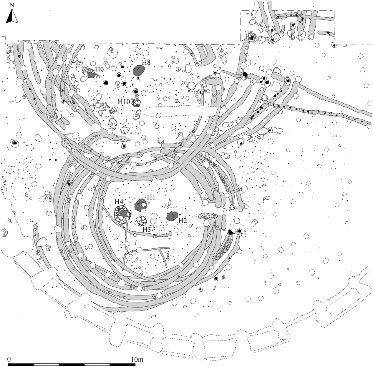
Fig. 2. Phase 3ii at Navan Fort, Co. Armagh with hearth locations highlighted. Inset of detail of inside of houses with feature numbers (after Lynn Reference Lynn1997a, figs 7 & 8; with kind permission of the Historic Environment Record of Northern Ireland (HERoNI))
The coherency of the group is thus not all that clear and rather than just reflecting a ‘messy reality’ of Royal sites (Armit Reference Armit, Haselgrove and Moore2007, 133), it is here argued that the group starts to break apart if we consider the actual activities taking place on them. Fundamental differences of function between Navan, Knockaulin, and Rathcroghan on the one hand and Tara on the other are obvious. Knockaulin, Navan, and Rathcroghan consist of a sequence of large timber structures with associated food consumption and craft activities. In contrast, the majority of excavated or documented monuments at Tara are funerary – from the Neolithic Mound of the Hostages, over the great number of possible Bronze Age barrows to the Iron Age burial ring-ditch beside the Mound of the Hostages and the various funerary elements of the Rath of the Synods. While the late phase of the latter monument’s sequence has been discussed as a possible ringfort (Grogan Reference Grogan2008), the evidence for this is ambiguous (Dowling Reference Dowling, Schot, Newman and Bhreathnach2011; Warner Reference Warner2013) and the association with an assemblage of Romano-British material further removes it from the core phase of activity on the site.
What all sites except for Rathcroghan share is their slightly elevated situation and internally ditched enclosure. This, however, can be paralleled in other sites outside the canon of Royal sites as per medieval literature: The consideration of Raffin (Fig. 3; Newman 1993; Reference Newman, Grogan and Mount1995) within his group of Developed Ceremonial Complexes (Newman Reference Newman1997) importantly took account of the morphological characteristics that align this site with the established range of Royal sites at Navan, Tara, and Knockaulin and opened the category beyond those discussed in the medieval narratives. Also, enclosures at Rathgall, Co. Wicklow and Ballydavis, Co. Laois are likely to have been internally ditched. While at Rathgall an argument can be made for the Late Bronze Age origins of a ditch with a – smallish – diameter of some 40 m, some evidence suggests that it may have been dug or modified in the Iron Age and to have had an external bank. In its Bronze Age phase Rathgall seems to offer strong links to Tara as a place of funerary (and metalworking) activity. The later addition of a large round building, that can probably be dated to the earlier Iron Age creates a strong link to Raffin and the other ‘Royal’ sites. At Ballydavis, Co. Laois (Fig. 4; Stevens Reference Stevens2011) Late Bronze Age activity and a possible Early Iron Age round-house were followed by a sequence of later Iron Age and early medieval burial monuments and ironworking activity, within and outside a probably internally ditched enclosure. Its substantial V-sectioned ditch enclosed the summit and had half-silted up when three fires were set within it, with oak charcoal from one of them providing a terminus ante quem of cal. ad 75–240 (95.4% probability; SUERC-9015, 1855±35 bp) for the creation of the ditch. One of two penannular ring-ditches that enclosed burials within the enclosure, contains a circle of widely spaced posts surrounding a possible figure-of-eight structure.

Fig. 3. Raffin, Co. Meath (after Newman Reference Newman, Grogan and Mount1995, fig. 5.6)

Fig. 4. Ballydavis, Co. Laois (after Stevens Reference Stevens2011, fig. 5) with kind permission of Transport Infrastructure Ireland
Both these sites expand the range of sites with internal ditch by yet another variant that seems to combine burial and metalworking with structural components. The nomenclature of the internally ditched enclosure thus unifies a wide and varied range of sites, some of which featured in later, medieval literature, whereas others did not. The presence of an internally ditched enclosure does not dictate or follow from a site’s function and neither is the group of ‘Royal sites’ mentioned in medieval narratives coherent or unique – breaking up the enduring conceptual hold that historic narratives have over the interpretation of these sites.
Space and form – the timber structures of the royal sites
The excavations at Navan and Knockaulin, as well as the geophysical imaging of the Rathcroghan mound, demonstrate the presence of sequences of large timber structures. Much debate has revolved around the question as to whether these were roofed buildings, unroofed timber post arrangements, or, as suggested for the reconstruction of the Mauve phase at Knockaulin, amphitheatres with staggered seating (eg, Wailes 1990; Reference Wailes2007).
Both at Navan Fort, as well as at Knockaulin, large figure-of-eight structures were excavated (Figs 1 & 2). These consist of two conjoined timber circles, orientated broadly on a south-west to north-east axis with entrances in the north-east. When first uncovered at Navan Fort, the southern elements of these structures were identified as large roofed houses as they contained hearths (Fig. 5) and occupational material, with the northern elements, interpreted as yards or byres, recently revised to be accepted as genuine figure-of-eight structures (Lynn Reference Lynn2006, 14). The large size of these structures, in particular that of site A/C at Navan and the Rose phase at Knockaulin, suggests that they would be difficult to roof with conventional roofing methods (eg, Lynn Reference Lynn2006). However, that they were roofed is suggested, first, by the presence of an external, third ‘slot’ at Knockaulin that is most likely to represent a drip gully around both southern and northern parts of the Rose phase structure (Lynn Reference Lynn2006), implying a roof from which water would have run off. Secondly, the apparent identification of hearths in the field plans of the northern elements of the figure-of-eight structures at Navan seems to provide further evidence for this (Fig. 2, highlighted). Hearths 8–10 are within the northern ‘yards’ of the figure-of-eight structure and likely to correspond to the three phases of buildings in this area (Lynn Reference Lynn1997b, fig. 7).

Fig. 5. Navan Fort, Co. Armagh. Hearths with flag stone setting in the southern part of the figure-of-eight buildings (after Lynn Reference Lynn1997a, pl. 9a, with permission of the Historic Environment Record of Northern Ireland (HERoNI))
Considered within a wider context it becomes apparent that these buildings are part of a tradition of constructions that consist of two concentric, contemporary double ring-slots/grooves. These multiple slots were interpreted by Lynn initially as consecutive phases of wall replacement with the roof remaining in situ (Lynn 1997d, 147–59), a theory recently revised but still envisaging only one slot trench at a time to have been in use (Lynn Reference Lynn2006, 8–13). However, the short slots, connecting the entrance posts of inner and outer slot trenches in a number of instances at Navan (Fig. 2), for example, show that they were indeed contemporary, as do those connecting the two slot trenches of the Rose phase at Knockaulin.
This construction method represents a fundamental departure from preceding Late Bronze Age traditions and was apparently applied to the construction of buildings with a diameter of over 9 m (Fig. 6). Their footprint consists of two ring-grooves or a ring-groove with an internal line of posts. These two closely spaced walls occur at a number of sites – as at Navan and Knockaulin – joined by a short stretch of wall forming an entrance, suggesting that the two wall lines are indeed contemporary and thus elements of a double-skinned wall. This is the case at Rathgall and Raffin, where a large circular structure in each case has been radiocarbon dated to around, or after, 800 cal bc on charred timbers from within their wall slots – in the case of Raffin even dated to a very narrow period around the beginning of the 8th century bc (Raffin: 2565±22 bp 810–590 cal BC, 2σ; UB-3712; Newman Reference Newman, Grogan and Mount1995, 62; pers. comm. Rathgall: SUERC-42581; 2465±29 bp 770–430 cal BC, 2σ; 760–410 cal bc). At Rathgall the partially surviving inner line of walling is formed by posts, continuing the line of an initial stretch of slot trench that contained planks and stone packing. Similarly, at Raffin (building B), wall timbers and post-pipes were documented within the slot trenches (Newman Reference Newman, Grogan and Mount1995, 62). Outside the range of these sites, a double slot trench, or ring- groove building was excavated at Moneylawn in Wexford (Fig. 6; Becker et al. Reference Becker, Armit, Swindles and Stanley2017) with further examples abroad at Broxmouth, East Lothian (Armit & McKenzie Reference Armit and McKenzie2013, 157), Wetwang Slack, Yorkshire (Dent Reference Dent2010, 20), and Great Woolden Hall, Salford (Harding Reference Harding2017, 65). In addition, at the Iron Age settlement of Melsonby (Haselgrove & Hamilton Reference Haselgrove and Hamilton2016b, 337–8, CS1 and CS2) and possibly at Rock Castle (Haselgrove & Hamilton Reference Haselgrove and Hamilton2016a, 329–31), both in Yorkshire, possible double skin structures are represented by combinations of slot trenches and stake-hole rings. Both single- and double-walled buildings reach quite substantial diameters of over 10 m. House B at Raffin had a diameter of c. 9–10 m diameter and buildings at Brook House Farm (Harding Reference Harding2017, fig. 2.22) and Kintore, Aberdeenshire (Cook & Dunbar Reference Cook and Dunbar2008, 326 – RH23) about 13 m without any visible internal supports.
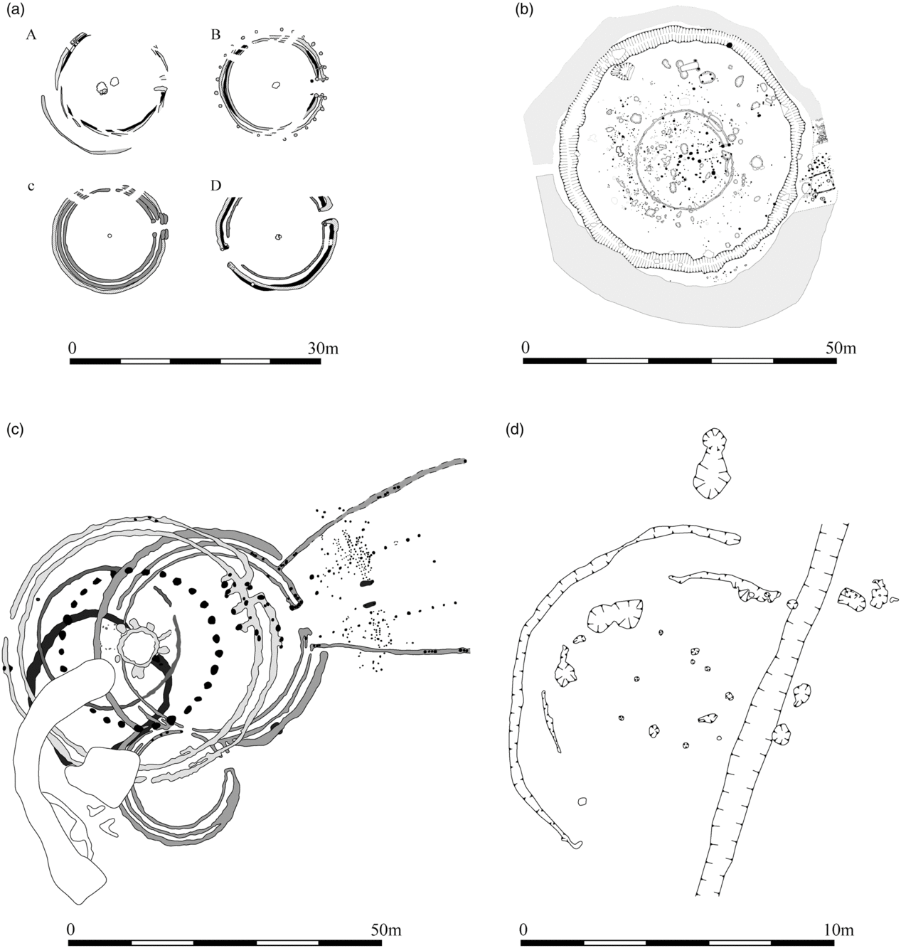
Fig. 6. Examples of double-skinned Iron Age structures: a. Navan Fort phase 3ii, southern elements of figure-of-eight structures (after Lynn Reference Lynn1997a, fig. 62, with permission of the Historic Environment Record of Northern Ireland (HERoNI)); b. Rathgall, enclosure ditch with 15 m structure; c. Knockaulin, (after Johnston & Wailes Reference Johnston and Wailes2007, fig. 2.1, courtesy of the Penn Museum); d. Moneylawn Lower, Co. Wexford, (after McKinstry 2011, with kind permission of Transport Infrastructure Ireland)
While it is unclear how structures beyond this diameter, as found at Rathgall, Raffin, Navan, and Knockaulin, would be roofed, it appears that walls of double ring-groove construction seem to facilitate the extraordinary size of these buildings. While in medieval double-skinned basket houses insulation materials such as moss provided insulation in the wall space (eg Deer Park Farms, Co. Antrim; Lynn & McDowell Reference Lynn and McDowell2011; see also Lynn Reference Lynn2003a), this would not add stability to a large construction. In the case of the Iron Age, plank- and post-built structures, the space may have been filled with sods or turves, providing stability and support for a substantial building without need for internal supports. The same argument as made for a building at Bancroft, Buckinghamshire, where two closely spaced rows of posts were also interpreted as a double-skinned wall (Williams & Zeepvat Reference Williams and Zeepvat1994, 35), while at Melin y Plas, Anglesey, double formations of narrow gullies have been interpreted as demarcating wide cob or clay walls (Smith Reference Smith, Cuttler, Davidson and Hughes2012, 69–71). How these could be the equivalent of commonly observed stone-faced rubble or turf walls is illustrated by the Bronze Age example from Lairg, Sutherland, where embanked houses produced evidence for internal wattle revetments (McCullagh & Tipping Reference McCullagh and Tipping1998).
Early medieval houses at Deer Park Farm as well as the Iron Ages structure at Platin-Lagavooren, Co. Meath (Lynch Reference Lynch2012) were wattle-built, allowing for the construction of a basket structure, which, as proposed in a reconstruction at Bosta, on the Isle of Lewis in the Outer Hebrides (Neighbour & Crawford Reference Neighbour and Crawford2001, fig. 8) may have been gabled to span both compartments. In Bosta, as well as in the case of the Royal site examples which appear to have had planked walls, the roof must have sat on a wall plate, but may itself have been constructed in a similar fashion to those of basket houses, consisting of woven and light elements (Lynn 2003a; Reference Lynn2006, 19).
The latest phases of building at Knockaulin and Navan Fort site B alike consist of circular buildings that dwarf those of the previous phases (Figs 7 & 8). The similarity of the Mauve phase and the 40 m structure of phase IV at Navan has been highlighted (eg, Lynn Reference Lynn1991). At Navan a large central oak post, as well as five circles of internal posts, mean the 40 m structure was structurally capable of supporting a roof and there is compelling evidence for such having been present as some posts were pushed 10–15 cm below their post-pits (Lynn Reference Lynn2003b, 30; 2003c, 36); the conclusion that this was a structure that carried a roof or a superstructure of enormous size is unavoidable (Lynn Reference Lynn2003b, 30–1). While the contemporaneity of multiple circles is still subject of debate for sites such as Ballacagen on the Isle of Man (Bersu Reference Bersu1977; Harding Reference Harding2017) or Candle Stane in Aberdeenshire (Romankiewicz Reference Romankiewicz2018), it seems to be evident at Navan Fort’s 40 m structure. At Navan, the evidence for the outer ring of posts originally having consisted of single ones, also pushed beyond their post-pits, and augmented by the addition of as second post in each case, further documents the enormous pressure that must have rested on the building (Lynn Reference Lynn1997a, 169–71),

Fig. 7. Knockaulin, Mauve phase (after Johnston & Wailes Reference Johnston and Wailes2007, fig. 2.14, image provided by S. Johnston, courtesy of the Penn Museum)

Fig. 8. Navan Fort Site B, 40 m structure (after Lynn Reference Lynn1997a, fig. 8, with permission of the Historic Environment Record of Northern Ireland (HERoNI))
The Mauve phase building at Knockaulin combines an outer double slot trench with an internal substantial post-ring and a central ring of posts that has been interpreted as an inner sanctum or tower without an entrance (eg, Wailes Reference Wailes1990). Instead, this can be argued to represent a central support for an upper floor or a support for a roof. In contrast to the central large oak post used at Navan Fort, this central support at Knockaulin consisted of a ring of posts that was surrounded by angled, abutting posts, indicating substantial pressures being compensated for. It is notable that this is, arguably, not a one-off construction but that the building of the White phase, with a diameter of about 20 m diameter, also had a central, circular arrangement of posts to provide additional support (Fig. 9).

Fig. 9. Dún Ailinne, White Phase (Johnston & Wailes Reference Johnston and Wailes2007, fig. 2.9, image provided by S. Johnston, courtesy of the Penn Museum)
This type of construction also seems to be represented at Rathcroghan. Two structures documented in geophysical analysis seem to adhere to the same multi-circle design. The northern ‘enclosure’ at Rathcroghan may represent a double-walled building with an outer diameter of 26 m and centrally placed features that may have, similarly, provided an internal support (Waddell et al. Reference Waddell, Fenwick and Barton2009, 154–5). On top of the mound itself a double enclosure (G40 & G46) of 32 m outer diameter consists of what seems to be paired posts set at a 1.5 m distance that may enclose a smaller circular enclosure (R18). This arrangement may have had an eastern entrance (G49; Waddell et al. Reference Waddell, Fenwick and Barton2009, 165–6, 175). These five examples from three sites suggest a widely known nomenclature of this forms of building that permits the construction of such exceptionally sized buildings across Ireland. The similarity between these, in particular the Mauve phase at Knockaulin and a similarly large building at Bancroft, is striking. At the latter, two outer double-skinned walls with a diameter of 18.3 m enclosed an internal post-circle and a central post (Williams & Zeepvat Reference Williams and Zeepvat1994, fig. 20). Here, as at Fison Way, Thetford, Norfolk, the existence of an upper level consisting of a central ‘tower’ with a lean-to roof around it has been proposed to explain the structural components extra to the standard two-ring round- house model (Gregory Reference Gregory1992, 48–52). While of a different ground plan, the monumental posts represented at Stanwick, Yorkshire (LS 1 & 2, Fitts et al. Reference Fitts, Haselgrove, Lowther, Turnbull and Willis2016, 79–89) were also discussed as indicating the presence of an upper level (Haselgrove Reference Haselgrove2016a, 89) and the existence of post-built towers – of rectangular plan – seems also evidenced in Denmark (Dengsø Jessen & Fiedler Terkildsen Reference Dengsø Jessen and Fielder Terkildsen2016).
While thus the argument for these structures having been roofed becomes stronger, even if this was not the case the very fact that the structures are modelled on houses is of crucial importance. Roofed or unroofed the fact that, morphologically, these structures can be considered to be moulded on the idea of a ‘great houses’ (cf. Lynn Reference Lynn1997a; Warner Reference Warner1994b; Bradley Reference Bradley2005, 75), seems to be at the core of what these sites are and stand for.
Funnels and approaches
Part of the range of characteristics often considered typical of the Royal sites are funnel-shaped avenues or approaches, such as those found at Knockaulin, Navan, and Rathcroghan. At Navan the two consecutive phases of the phase 3ii–iii figure-of-eight buildings were accessible through funnel-shaped palisaded avenues orientated towards the north-east of the site. These crossed the causeway of the enclosure ditch of preceding phase 3i to an, as yet unlocated, exit in the east of the site. At Knockaulin (Johnston et al. Reference Johnston, Campana and Crabtree2009) geophysical imaging revealed an avenue that connects the northern building of the Rose phase structure to an enclosure that is located within the extant, internally ditched rampart (enclosure 6, Fig. 10) and it is likely that the avenue pre-dates this larger enclosure.

Fig. 10. A model of the sequence of enclosures and structures at Knockaulin, Co. Kildare; a. Rose phase. The figure-of-eight structure excavated by Wailes could be shown to link in with an enclosure evidenced in the geophysical survey (Johnston et al. Reference Johnston, Crabtree and Campana2014); b. White phase. The double ring structure of the White phase follows stratigraphically the Rose phase, but pre-dates the building of the Mauve phase. It is unclear if this phase was enclosed and if so, if the enclosure of the Rose phase as suggested here still existed; c. Mauve phase. The last and largest building at the site is here hypothesised to have been contemporary with the internally ditched enclosure. Features that are here attributed to a phase are outlined in black, undated features in grey. A third enclosure revealed by the geophysical survey pre-dated the last internally ditched enclosure but is otherwise undated (not illustrated)
At Rathcroghan a similar constellation is visible in the geophysical images (Fig. 11). A funnel-shaped avenue led from an outer enclosure G2 and its entrance to the inner enclosure encircling the mound (Waddell et al. Reference Waddell, Fenwick and Barton2009, 154–5; Schot et al. Reference Schot, Waddell and Fenwick2016). Within the interior of the inner enclosure, on the mound, a second avenue that leads up to the enclosed house can be recognised in the geophysical images (Fig. 12, A1). This arrangement of an avenue leading to a smaller enclosure with a circular structure is mirrored immediately north of the mound, also within an outer enclosure, (‘enclosure’ G14, Fig. 11).

Fig. 11. Geophysical survey of Rathcroghan, Co. Roscommon. G2 outer enclosure, G1 inner enclosure around the mound, G14 enclosure north of the mound with its avenue G33 and G34 (Waddell et al. Reference Waddell, Fenwick and Barton2009, fig. 5.5, reproduced with kind permission of J. Waddell and Wordwell Books)

Fig. 12. Geophysical survey of Rathcroghan, Co. Roscommon. G1 enclosure around the base of the mound, with entrance in the east, A1 possible avenue. G40 and 46 – double post ring structure. G51 is a further circular structure that may have an eastern entrance G49, that may link in with A1. G41 is a feature that seems to form part of the make up of the mound, but possibly also represents a further circular structure on its summit (Waddell et al. Reference Waddell, Fenwick and Barton2009, fig. 5.21, reproduced with kind permission of J. Waddell & Wordwell Books)
These ‘avenues’ have been discussed as facilitating processions, for example as part of performative, ritual action, serving to create and maintain the centralised power structures at Knockaulin (eg, Johnston et al. Reference Johnston, Crabtree and Campana2014) and the public nature of these events is deduced from the large size of the structures (ibid., 206–7). Like the figure-of-eight structures, avenues have joined the range of features that are commonly considered diagnostic for ‘ritual’ Iron Age sites, and the presence of a similarly defined approach to a large round-house at Lismullin (see below) has contributed to the discussion of this site as a temple (Fig. 13; O’Connell Reference O’Connell2013). A recently excavated site at Ardloy/Springfield, Co. Sligo, similarly may have a short, fenced approach connecting the entrance of a circular palisaded enclosure with a centrally positioned house (Fig. 14; O’Hara Reference O’Hara2018). At Mell, Co. Louth (Fig. 15; McQuade Reference McQuade2005) two ditches possibly formed part of a funnel-shaped approach to an enclosure and a tentative similarity may be seen in a short stretch of parallel wall slots leading to a figure of-eight basket structure at Platin-Lagavooren, Co. Meath (Fig. 16; Lynch Reference Lynch2012).

Fig. 13. Lismullin, Co. Meath (after O’Connell Reference O’Connell2013, ill. 4, 3, with permission of ACS Ireland Ltd & Transport Infrastructure Ireland)

Fig. 14. Ardloy/Springfield 4, Co. Sligo (after O’Hara Reference O’Hara2018, with kind permission of Brian O’Hara, IAC Ltd & Transport Infrastructure Ireland)

Fig. 15. Mell, Co. Louth (after McQuade Reference McQuade2005, fig. 2)

Fig. 16. Platin-Lagavooren, Co. Meath (after Lynch Reference Lynch2012, fig. 4 with permission of IAC Ltd and Transport Infrastructure Ireland)
The size of the posts delineating the avenue at Knockaulin, with a post-hole diameter of 43 cm suggests fencing of a considerable height. This inner line of posts was augmented, or possibly replaced, by a second line of fencing represented by slot trenches. This barrier would have shielded the potential path of the procession from view both from surrounding areas and from within the interior of the structure and its hypothetical viewing platform/seating. This may, as argued in the case of the ‘Banqueting Hall’ at Tara, be explained as the management of views of the surrounding landscape afforded to members of the procession (Newman Reference Newman2007).
However, constructional details of the avenue at Knockaulin suggest a functional complexity that may indicate another purpose than that of processions (Fig. 17). The funnel-shape of the avenue itself seems important and may be designed to guide the movement of, and gather together, a large group of individuals – human or animal – into the structure. This notion is reinforced by the fact that a short distance from the entrance to the Rose structure the avenue is cut across by a fence with a centrally located gate that appears to have seen several stages of rebuilding and repair, as indicated by at least two lines of fences or screens crossing the approach. This suggests a need to further control access to the structure, notably of subjects that are already within the site, after having entered through the outer enclosure. This arrangement speaks for the management of herds, rather than of a self-structuring, socially controlled, and co-ordinated groups of people in procession, though of course both uses may not have been mutually exclusive. If the management of life stock was indeed the purpose of the avenues, they were meant to be led into the northern part of the structures, though the funnelled avenues, as may be indicated by a base layer of apparently deliberately introduced cobbles in the east (Lynn Reference Lynn2003b).

Fig. 17. Knockaulin Rose phase avenue (Johnston & Wailes Reference Johnston and Wailes2007, fig. 2.4, digital file provided by S. Johnston, image courtesy of the Penn Museum)
Importantly, regardless of whether the northern portions of these structures are interpreted as open yards or parts of roofed buildings, the figure-of-eight arrangement seems to be a response to a need for separation of functionally different zones. Similar ideas about the differentiation of space are found in literary sources for the early medieval period that suggest the use of portions of figure-of-eight structures as backhouse, outhouse, or kitchen (O’Sullivan et al. Reference O’Sullivan, McCormick, Kerr and Harney2008, 231). The differentiation of people and activities in public and withdrawing spaces within medieval castles suggests a further social dimension of the organisation of space inside buildings (Johnson Reference Johnson2002). In addition to the shape of the ground plan it is the construction details of the entrance gaps of the Rose structure that speak to functional differentiation: The clearance of the gate intersecting the avenue as well as that of the entrance to the northern structure is 3 m. In contrast, both the entrance to the southern part of the figure-of-eight house as well as the connecting entrance between southern and northern parts of the structure were only c. 1.5 m wide. It is thus possible to envisage the driving of livestock, and vehicles, through the avenue into the northern element of the structures, with the southern element only accessible by more narrow entrances, reserved for humans.
The function of the avenues as droveways leading up to the figure-of-eight structures had been pondered for Navan (Lynn Reference Lynn1997b, 214; Waddell Reference Waddell2018, 23) and also for double earthworks such as Tara’s – medieval – Banqueting Hall or Rathcroghan’s Mucklaghs (Waddell Reference Waddell2010, 379). The best parallels for the articulation of the avenues of the Royal sites can, however, be found in Wales and England. Iron Age enclosures here have often been shown to contain house structures (Fig. 18; Murphy & Mytum Reference Murphy and Mytum2012, fig. 3b, eg, Woodside); and on occasion evidence for the drove way or avenue to be tied into an outer enclosure (eg, ibid., fig. 3b & fig. 3a; Trefereed Uchad fig. 8; Llwyn-du Bach: Manley Reference Manley1991; cf. Ghey et al. Reference Ghey, Edwards and Johnston2008, 11, fig. 4). Related banjo enclosures – that can enclose house structures – have upon excavation also shown evidence for internal ditches (Perry Reference Perry1974, 71; Lang Reference Lang2016, 346, 353, 349) and have been discussed as functioning to divide and corral cattle (Moore Reference Moore2012, 409; Lang Reference Lang2016).

Fig. 18. Enclosures in Wales (Murphy & Mytum Reference Murphy and Mytum2012, fig. 3)
In a move away from entirely functional explanations of British banjo enclosures, their social function has been explored (Hingley Reference Hingley, Cunliffe and Miles1984; Moore Reference Moore2012; Lang Reference Lang2016) but, importantly, they have been shown to facilitate transhumant movement between geological zones suitable for sheep pasture and better watered pastures, suitable for grazing cattle and horses. Providing access to different landscapes, they were tied with earthworks into systems of landscape management and movement of stock and possibly people (Moore Reference Moore2012, 409–10). Similarly, the antenna ditches attached to the Iron Age settlement enclosures of Little Woodbury, Wiltshire and Gussage all Saints, Dorset have been interpreted as means of channelling stock into the sites (Harding Reference Harding2017, 49).
The most striking parallel for the Irish Royal sites was excavated in Moss Carr in West Yorkshire (Fig. 19), where a funnel-shaped avenue led to a figure-of-eight structure that had been repeatedly rebuilt in the same location (Roberts & Richardson Reference Roberts and Richardson2002; Harding Reference Harding2017, 47–9). Similarly, at Bryn Eryr in Anglesey, 0.5 m wide gullies formed an approach to the worn yard of a round-house. This approach was maintained in a later phase when a second house was added to it, both buildings conjoined so closely that they resemble a figure-of-eight structure (Longley Reference Longley1998, 227–32, figs 2 & 22).

Fig. 19. Moss Carr, West Yorkshire (after Harding Reference Harding2017, fig. 2.15)
Further afield in Norway funnel-shaped arrangements of low field walls are thought to have guided livestock into Bronze Age long-houses (Fig. 20; Myhre Reference Myhre1980; Rønneseth Reference Rønneseth2001). This may be to facilitate lambing or calving, shearing, trading, or other occasions in the agricultural calendar that required the bringing together of animals, ideally in a protected environment, as argued for long-houses in Bronze Age Norway (Armstrong Oma Reference Armstrong Oma2018, 118–19).

Fig. 20. Bronze Age longhouse at Ullandhaug, Norway (photo: Kristin Armstrong-Oma)
Singularity
The fact that, at Rathcroghan, two virtually identical arrangements of such possibly contemporary structures are found is striking and may provide significant insights into the development or process of these activities. Indeed, much previous interpretation derives from the presumed ‘unusual’ and extraordinary, singular character of the structures found on these sites. However, increasingly it is becoming clear that they not only formed (as argued above) part of a broader corpus of related architecture but also that the large structures do not stand alone even on the Royal sites themselves. The presence of adjacent and possibly contemporary structures at some of these sites may suggest that the large structures were focal points of a larger accumulation of structure, that may well be houses.
At Navan circular slot trenches of structure D, structure R, and a further, slighter slot trench (58) truncated by the later ring slot B3, were documented within the area defined by the southern parts of figure-of-eight structures H and K. The first two represent a further figure-of-eight structure, whereas slot trench 58 may have represented a simple circular structure. Waterman (Reference Waterman1997) suggested that structure D had never been finished, as the slot trench was filled with redeposited natural soil and no evidence for posts was forthcoming. If planks or a basket construction were based in these slot trenches, post-holes would not be expected and the slot trench could have been infilled with redeposited natural soil upon the removal of the structure. The sequence of site A/C at Navan (Lynn Reference Lynn2000; Mallory & Lynn Reference Mallory and Lynn2002) overlapped chronologically partially with Site B, suggesting complexity of site function and development – the earlier figure-of-eight structure comprising this site post-dating stratigraphically one of the slot trenches extending from phase 3ii of site B and its later ringfort type enclosure, producing a terminus ante quem from upper layers of its fill (Lynn Reference Lynn2002; Bayliss and Grogan Reference Bayliss and Grogan2013, 117–28, fig. 123). The figure-of-eight structure at site A/C post-dates the sequence of comparable structures at site B, before – after a possible hiatus in activity – the 40 m structure was constructed at site B. The later round-house (phase B) at site A/C remains undated though a charcoal date from an upper level of the ditch fill of its enclosure provides a terminus ante quem somewhere near the end of the Iron Age (Bayliss & Grogan Reference Bayliss and Grogan2013, 128–9, fig. 15) and two undated extended inhumation burials positioned in front of its entrance may support this late date.
At Knockaulin (Fig. 10), the geophysical survey completed circular features that had been partially uncovered during the original excavation: feature 8 of the geophysical survey completes the double-arc of post-holes 229 discovered in the excavations to the west of the structure to a full circle c. 20 m in diameter. It is tempting to interpret this as the possible remains of a very large double-walled structure. The survey also identified a similarly large feature immediately to the north of the main cluster of features (feature 13). A group of round structures (feature 15) pre-dates Rose phase enclosure 6, but sits within the confines of a second, possibly earlier, enclosure ditch that was identified in the geophysical survey (feature 9).
Likewise, at Rathgall further large structures are implicated in the geophysical survey and, at Rathcroghan, rebuilds on the same location are represented in the geophysical data for the northern building and several phases of rebuilding appear likely for the building on the mound (Waddell et al. Reference Waddell, Fenwick and Barton2009, 142–56, 167).
Action
Navan Fort and Knockaulin have produced a significant number of artefacts and ecofacts in substantial, charcoal-rich deposits. The presence of these deposits suggests significant levels of sustained human activity on these sites – resembling, by all accounts, what in any other context would be interpreted as occupation evidence. Among this material, some finds stand out as special deposits. The famous Barbary Ape skull found at Navan (Napier & Jenkins Reference Napier and Jenkins1997; Raftery Reference Raftery1997b), the complete La Tène sword from Knockaulin (Johnston & Wailes Reference Johnston and Wailes2007), the presence of human remains there and at the Ráith na Ríg at Tara (Roche Reference Roche2002), as well as of a human clavicle among the stones of the cairn at Navan (McCormick Reference McCormick1997, 120) are striking and ‘special’, as are the spear-butts from Tara and Navan, the decorated dress pins from Navan and Knockaulin, or indeed the other items of personal ornamentation such as glass beads, pins, and fibulae – all likely deliberate deposits. However, the presence of special deposits on settlement sites is a common occurrence in later prehistory, both in Bronze Age Ireland and Britain (eg, Hill Reference Hill1995; Brück Reference Brück1999a; Armit & Ginn Reference Armit and Ginn2007; Cleary Reference Cleary2018). Structured deposits of artefacts and human remains on hillforts and other settlement sites show how cosmologies and domestic or everyday practices are intertwined and defy categorisation or separation and do not render the Irish sites purely ritual temples or ceremonial centres.
A number of on-site activities are evidenced within the range of artefacts. Metalworking – iron and bronze – as well as glassworking is represented at Tara in the pre-bank phase (Roche Reference Roche2002, 39–43; Crew & Rehren Reference Crew, Rehren and Roche2002). At Knockaulin, iron smithing evidence was associated with the Rose and Mauve phases in particular (Johnston Reference Johnston2007c, 145) and a casting jet and possible bar ingots suggest bronze smelting (Johnston 2007e, 109–10). A possible tracer suggests the decoration of bronze or gold objects (Johnston Reference Johnston2007d, fig. 8.5, pl. 8.5). Also at Navan metalworking, woodworking (a possible drill bit), lignite- or shaleworking (half-finished rings and a lignite pendant; Lynn et al. Reference Lynn, Raftery, Henderson and Warner1997, 85–9), and possibly glassworking were practised (Henderson Reference Henderson1997). Some of these activities could be attributed to the construction of the large timber structures (cf. Johnston Reference Johnston2007b, 203): whetstones, metal blades, and tools from Knockaulin; the socketed iron axehead, bronze and iron nails as well as bracket and a joiner’s dog from Tara (Roche Reference Roche2002, 43). On the other hand, they may also speak of complex woodworking activities taking place here that could equally be considered as evidence for a more enduring presence of people on site, the possible drill bit from Navan, for example, representing most likely more delicate woodworking techniques than those required in the creation of the large timber structure.
This possibility is also underscored by the evidence for subsistence and craft activities such as a sickle or artefacts related to textile production, such as spindle whorls and weaving or matting needles at Knockaulin and Navan as well as needles and a weaving comb from site A/C at Navan (Raftery Reference Raftery1997a, 138; Crabtree & Campana Reference Crabtree, Campana, Johnston and Wailes2007). The rare survival of an Iron Age bone artefact assemblage demonstrates not only that this material was used for the production of spindle whorls and needles, ornamental dress pins (Fig. 21a) and mounts created in this otherwise rarely preserved material, but also provides evidence for the working of this material on site in the form of form of half-finished and waste material at Knockaulin (Fig. 21b; Crabtree & Campana Reference Crabtree, Campana, Johnston and Wailes2007, 167), as well as at Navan (Mallory Reference Mallory2000, 38; McCormick Reference McCormick2000, 38). At Tara antler may have been worked (McCormick Reference McCormick2002, 108) and the presence of exclusively deer metapodia and phalanges at Navan Fort may suggest deer hide processing (McCormick Reference McCormick1997, 120). The evidence for textile production in the form of spindle whorls, needles, and the aforementioned weaving comb on these sites is supported by the age profiles of the sheep at Tara (McCormick Reference McCormick2002, 106). The fact that at both Navan and Knockaulin significant numbers of pits were found within the interior of the structures also suggests longevity of use, possibly even the storing of stock or materials.

Fig. 21. a. dress pin; b. worked bone from Knockaulin (image provided by S. Johnston, courtesy of the Penn Museum)
These assemblages are rarely reflected on, with the exception of Johnston, who acknowledged the co-existence of secular and ritual activities on site and the great variety of craft activities (Johnston Reference Johnston2007b, 20), though without considering this material as ‘ordinary domestic debris’ (Johnston et al. Reference Johnston, Crabtree and Campana2014, 212). Allowing for occupation in close vicinity to the structures at Navan Fort, Raftery wrote, in 1997, about the weaving comb from Navan fort that ‘we are thus reminded of the very extensive area of the enclosure which has not been excavated and of the possibility that Navan, as well as serving as a presumed ritual centre, was also the scene of a secular settlement during the Iron Age’ (Raftery Reference Raftery1997a, 138).
The 40 m structure at Navan Fort did not produce any artefactual or bone assemblage and the spreads of soil in some areas of the building are argued to be upcast from the digging of the large post-pits – suggesting that the building was infilled and destroyed soon after its construction (eg, Lynn Reference Lynn1997b, 212–13; Reference Lynn1997c, 37). However, there is some architectural evidence for alterations or modifications to the building (Lynn Reference Lynn1997a, 40–2, 213; Romankiewicz Reference Romankiewicz2018, 20–1) which may suggest a longer life span of this building than often envisaged. Any possibly accumulating materials may have been removed before the destruction of the building or, indeed, no residue-producing activities may have taken place, suggesting a change in activities in this phase in this particular location.
Seasonality
A major factor that structured past thinking on the functioning of these sites is the evidence for seasonality in the slaughter patterns observed in the animal bone assemblages. At Knockaulin a high proportion of slaughtered cattle were, based on the tooth evidence, slaughtered at about 3 months of age and a further group at about 6 months (Crabtree Reference Crabtree1990, 24). The slaughter age of pigs at maturity may suggest that they were killed in the autumn before their second overwintering (McCormick Reference McCormick1997, 119). This, in itself, should primarily reflect the rhythm of pastoral regimes rather than of site use but has, in conjunction with often-referenced evidence for intermittent or episodic activity at Knockaulin, contributed to the frequently cited narrative of the sites as places of episodic congregation and feasting. This was also anchored on the make-up of the Flame phase deposits: in this phase episodes of vegetation growth alternated with deposits of anthropogenic material comprising animal bones, charred material, and burnt stones (Wailes Reference Wailes2007, 21). While relatively loose in composition and thought to comprise redeposited material (due to the lack of evidence for in situ burning) the excavator noted very thin, stone free lenses of humic material throughout this deposit, indicating short periods of inactivity during which patches of vegetation developed ‘comparable to the patchy vegetation over a year or so on the spoil heaps of excavation’ (Wailes Reference Wailes2007, 19). The Flame layer is the horizon from which the greatest number of the large assemblage of animal bones at Knockaulin stems: 5604 bones of a total of 16,864 (33.2%: identified and unidentified) and 55 of the overall 201 MNIs (27.4%: Crabtree Reference Crabtree, Johnston and Wailes2007, tables 13.1 & 13.2). Thus, a great part of the feasting activity, including the evidence for the roasting of meat (Wailes Reference Wailes2007, 21) and, in particular, the evidence for episodic use of the site is restricted to the Flame phase, which represents the last phase of use of the site – post-dating the large buildings and the dismantling of the Mauve phase 40 m structure. While the high number of animals associated with this phase may be the result of advantageous conditions for preservation presented by the looser and dryer character of the Flame deposits and less disturbance to this than the underlying layers would have been exposed to (Wailes Reference Wailes2007, 21), there is currently no evidence to suggest intermittent activity in the preceding phases here or at any of the other Royal sites. Interestingly, however, the evidence from the Flame phase actually seems to suggest that the site became the focus for repeated visits after the destruction of the large building, including the roasting of meat on open fires on top or beside the dismantled remains of the Mauve phase structure. The Flame layer also contained one of the two human bone finds from Knockaulin – a fragment of skull (Crabtree Reference Crabtree, Johnston and Wailes2007, 156).
Feasting
The presence of large animal bone assemblages further serves to underpin the importance of livestock on these sites. The evidence suggests that live animals were brought up to the site, slaughtered, and consumed here. The proportions of different species vary from site to site but cattle, pig, and to a lesser degree sheep and horse, dog, and occasionally deer were consumed on all three sites. While the slaughter patterns of the cattle have been discussed controversially in regard to dairying versus meat production (McCormick Reference McCormick2002, 105–6; Crabtree Reference Crabtree, Johnston and Wailes2007, 162), the presence of the bones on the sites has been discussed primarily as the result of ‘feasting’ and, as such, firmly placed within the range of ‘non-domestic’, ‘ non-utilitarian’, or ‘ritual’ activities taking place on these sites. Feasting is, however, not an end to itself, detached from ‘real, domestic’ life, but marks and facilitates a variety of different significant social occasions. These may have included particular events in the agricultural cycle that were actually focused on the management of livestock, as suggested above for the figure-of-eight phases at some sites. Sheep flocks, for example, may be brought in for shearing or for separation into owners’ lots in the lambing season (Armstrong-Oma Reference Armstrong Oma2018); pigs may have been brought in to be slaughtered before the winter season; and cattle possibly in spring and autumn (Crabtree Reference Crabtree1990, 24). These major events within a community’s lifecycle may been accompanied by festivities and indeed feasting. The animals that constitute the focus of the event, as for example sheep in the lambing season, may not feature significantly in the animal bone record that results from the accompanying feasting, where pigs and cattle would dominate. It is nonetheless interesting to observe that the NISP of sheep bones is the highest in the Rose phase at Knockaulin at 38.9%, in contrast to the White and Mauve phases; also the other Iron Age phases contained about 25% of sheep, with the exception of Lower Emerald and Dun (Crabtree Reference Crabtree1990, 23, table 1). These animals – as horses also – were probably slaughtered when they were not suitable anymore for their primary function of riding, traction, or indeed wool production. The primary use of the horses consumed here for riding is evidenced by bridle wear on a horse tooth from Tara (McCormick Reference McCormick2002, 107) and the ageing data for sheep at Tara that suggests their use for wool production (ibid., 106).
Royal sites in their settled landscape
As outlined above, the questions of subsistence methods, lifeways, and society organisation have been entangled with the interpretation of the Royal sites. Models of highly mobile pastoral, or even nomadic, society roaming Iron Age landscapes were constructed out of the apparent contrast between the physicality of the ‘non-functional’ Royal sites and the absence of evidence for settlement.
Evidence for Iron Age settlement and agriculture has increased in the last 20 years or so. While still significantly less plentiful than in the Late Bronze Age or the early medieval period, securely dated evidence of barley and wheat underlines that arable agriculture was practised in various parts of the country in the second half of the 1st millennium bc (cf. Plunkett Reference Plunkett, Salisbury and Thurston2009) and a number of sites around Tara have produced evidence for both pastoral and arable agriculture practised in a relatively densely settled landscape in both the early medieval period (O’Sullivan & Kinsella Reference O’Sullivan and Kinsella2013, 363 or 373) as well as the Iron Age (eg, Becker Reference Becker2013). This evidence suggests settlement and agricultural activity in this landscape not far from the Hill of Tara, supported by evidence in the form of cereal grains found at Lismullin, Screen 3, Ross 1, and Roestown and arable weeds at Lismullin and Screen 3 (O’Connell Reference O’Connell2013, 60), at Lismullin demonstrably reaching back into the earlier part of the Iron Age.
Lismullin (O’Connell Reference O’Connell2013) is one of two enclosures excavated close to Tara. A double palisade enclosed a large round structure that was connected by an avenue or fenced path with an elaborate gate construction. A slight dip in the topography and drainage issues in the locality led the excavators to argue against an occupational function of the site and the structural remains were interpreted as a henge-like temple (ibid.). However, the preceding and consecutive use of the site, consisting of grain storage in the Bronze Age (a four-poster structure) and kilns in the early medieval period, speaks loudly to the usability of the location for agricultural and settlement purposes. A sub-rectangular structure immediately south-west of the round-house produced dates that place it broadly before or contemporary with the house and a relatively high proportion of animal bone was associated with it, again underlining the continuous use of the locality for subsistence related activities. The presence of two linear parallel ditches north and south of these buildings were filling in until 700–500 bc as established by OSL. These, as well as ditch 2936 that produced an Early Iron Age date and stratigraphically pre-dates the central round-house, may have provided drainage for the site. Neither the association of animal bones with the rectangular structure nor the pits and post-holes that represent an earlier phase of activity in the interior of the circular structure and have been interpreted as shrines (O’Connell Reference O’Connell2013, 60–1) can be taken as evidence for such a function.
The need to construe overly mobile societies has thus lessened as the organisation of all of Iron Age society exclusively around livestock – as characteristic for pastoral societies – becomes untenable. This is not to ignore the fact that no binary contrast between sedentary and mobile communities is anymore envisaged in anthropological models, but rather a range of varying modes of lifeways, often co-existing and collaborating (cf. Rollefson et al. Reference Rollefson, Rowan and Wasser2014; Honeychurch & Makarewicz Reference Honeychurch and Makarewicz2016, 343). However, nomadism, an adaptation to scarce resources, is commonly found in landscapes of ecological extremes, unlike Ireland, and is characteristically restricted to herbivores. The keeping of pigs, so strongly represented in the animal bone records of the Irish Royal, but also other, sites is rarely observed in pastoral or nomadic communities.
The animal bone assemblages from Knockaulin and Tara contained large proportion of pigs, making them the second most important species there (McCormick Reference McCormick2002, 104) and they were the dominant species at Navan’s site B (McCormick Reference McCormick1997, 118). At Navan, Knockaulin, and Tara pigs were mainly slaughtered maturely (18 months to 2 years at Navan (McCormick Reference McCormick1997, 119); and 2.5 years at Knockaulin; Tara mature or old (McCormick Reference McCormick2002, 106)). This was presumably the optimum age for consumption, comparable to recent non-improved breeds. This suggest that pigs, as cattle, were actively managed livestock with the neutering of male and possibly female pigs as piglets in order to suppress aggressiveness and avoid a boar-taste to the meat.
A slaughtering age of over a year may suggest that the pigs were kept in an extensive livestock farming mode, ie, either roaming within a restricted area or moving in the landscape with a swineherd. Pigs kept intensively tend to fatten up more quickly and the comparable non-improved breed of the Iberican pig has an ideal age for slaughter around 12 months (Hadjikoumis Reference Hadjikoumis2012, 357–8; 363). Medieval swine have similarly been shown to be slaughtered close to 2 years of age (Campbell Reference Campbell2006, 165). This speaks for seasonal slaughter after the acorn mast in oak forests which, in Ireland, would be in late autumn or winter. Intriguingly, a broad consistency of the slaughter ages has been argued to reflect an organised and planned structure of pig farming, not unlike that observed in the large-scale production in Iberia today – in stark contrast to small scale independent unit breeding that operates more independently of natural food supplies (Hadjikoumis Reference Hadjikoumis2012, 362). This would, in the case of the Irish sites, suggest a larger market to be the target of production, rather than small, self-sufficient units or the ongoing demands of a smaller region. However, the availability of food stuffs and climatic considerations may also have led to targeted breeding in extensive pig keeping practices (ibid.). It is tempting to see this as additional evidence for a central role of the Royal sites in the management of livestock, possibly as distribution centres for produce. Such large-scale production appears anachronistic but, in fact, has recently been demonstrated at Hallstatt, Austria where, in the Late Bronze Age, large amounts of pig sides were processed and cured (Hammer et al. Reference Hammer, Tautscher, Pucher, Kowarik, Reschreiter, Kern and Haring2018).
It is tempting to argue that a variety of livestock, including pigs, were brought together to the sites on a seasonal basis, with the funnel structure facilitating the movement of the animals into buildings, as argued above. The northern, funnelled houses could have functioned as byres and a possible upper floor of the large house of the Mauve phase at Knockaulin would allow such use of the ground level, explaining the absence of occupational evidence on ground level. The evidence for consumption of large amounts of meat may indeed be evidence for feasting accompanying these events. These consumption patterns may not be representative of everyday practices but this does not take away from the possible function of these sites in complex networks of agricultural production.
Infield/outfield
While this emphasis of livestock management may at first sight support traditional narratives of pastoral Iron Age society, there is also some indication that the Royal sites and, indeed, the funnels themselves played a role in arable agriculture: the very existence of avenues could also be read as an indicator of an arable regime being practised on site. At Knockaulin and Rathcroghan – possibly also at Navan – the avenues were directly linked into larger enclosures, thus not only defining and creating controlled access to the houses but at the same time preventing access to the remainder of the interior of the enclosure. The rest of the large enclosed area may conceivably have been dedicated to arable agriculture in an infield–outfield type of agriculture – considered but ruled out as an option by Lynn (Reference Lynn1997b, 214). As argued for the southern English banjo enclosures, the morphology of the sites appears to primarily facilitate access while dividing off an internal space from the larger area within the enclosure – unifying the diverse range of sites on a fundamental level (Moore Reference Moore2012, 405). At Rathcroghan, within the large enclosure (G2), truncated remains of ridge and furrow cultivation were identified (Waddell et al. Reference Waddell, Fenwick and Barton2009, 145) which indicate the position and orientation of a number of small plots surrounding the central mound. Waddell et al. speculated about a medieval date of these fossil field plots (Reference Waddell, Fenwick and Barton2009, 146) and pointed out that the fact that cultivation patterns on either side of the enclosure differ in their orientation indicating that the enclosure was at least still upstanding when these fields were cultivated (Waddell et al. Reference Waddell, Fenwick and Barton2009, 147–8, fig. 5.7). He suggested an early medieval date for the fields, but likewise an Iron Age date is conceivable.
DISCUSSION
The big house
The evidence for intense and varied use of the sites under discussion here, their architectural link with agricultural practices, as well as their location in lived-in, agricultural landscapes challenges conceived ideas, already previously critiqued on methodological grounds. Also, the concept of one coherent group has been shown to begin to disintegrate and the group to overlap with sites outside the range of ‘Royal sites’ defined in medieval times, such as Rathgall, Ballydavis, Ardloy, Lismullin, and Raffin. This further suggests the redundancy of this term for the prehistoric phases of these sites. Rather than focusing on binary interpretational oppositions and ‘in and out’ criteria, a return to the archaeological evidence thus becomes possible.
A particular focus in this paper has been placed on the large timber structures found on some of these sites. It has been argued that these structures are houses and that a range of activities took place within them – unlikely to be related only to the event of construction but actually part of the use of these sites. This does not mean that these are ‘ordinary’ or purely functional domestic spaces. Their functionality – providing shelter and acting as a space for the conduction of a variety of craft and manufacturing activities and possibly the long-term stay of people and animals – should by no means be understood to mean that their significance, function, and meaning is limited to this. It is helpful to consider that architecture, even if it has a functional purpose, is far from the unavoidable result of purely functional considerations. Rather, houses can be considered the ‘direct and unself-conscious translation into physical form of a culture, its needs and values, as well as the desires, dreams and passions of a people. It is the world view writ small, the ‘ideal’ environment of a people expressed in buildings and settlements, with no designer, artist or architect with an axe to grind’ (Rappaport Reference Rappaport1969, 2). Arguably, the sharing of house forms across wide parts of the country thus suggests that the fundamentals of a particular model of an ideal environment are shared across these regions and reflects a shared value system and image of the world (Rappaport Reference Rappaport1969, 6).
Structures and houses may embody cosmologically important concepts and discussions of the spatial arrangement of the compartments of the 40 m structure at Navan, the monumentality of its central post, and the encasement of the structure in its last phase, contribute significantly to such debates (eg, Robertson Reference Robertson1992, 27; Lynn Reference Lynn1994). But that does not mean that they were one-dimensional in their function; ‘It is one thing to say that the dwelling has symbolic and cosmological aspects, that it is more than a device for the maintaining of the equilibrium of the metabolism, and another to say that it has been erected for ritual purposes and is neither shelter nor dwelling, but a temple’ (Rappaport Reference Rappaport1969, 40).
This conceptual complexity of architecture is illustrated for example by the large meeting houses of Maori culture that serve intertribal and intersubtribal relationships. The houses developed in colonial times to facilitate discussions that dealt with issues arising out of the presence of the Europeans – needs specific to a very particular historic setting. Developing over time into symbols of identity and incorporating ancestral genealogies into decoration and architecture, they not only represent a merging and layering of concerns and issues, but furthermore also drew on the architecture of mission houses (eg, Bradley Reference Bradley2005, 48–50; von Meijl Reference Von Meijl and Fox2006; Brown Reference Brown, Köpke and Schmelz2012).
The ontology of the house may also have been a very different one than for us, houses were in some cultures perceived as living beings and ideas about the central post at Navan, for example, as representing an oak tree (Lynn Reference Lynn1992) and ‘philosophical or magical aspects’ represented in the layout of the posts (Lynn Reference Lynn1997b, 225; Waddell Reference Waddell2018, chap. 6) could indeed possibly be an indication of such different ontologies. Likewise, the possible archaeoastronomical alignment of elements of the enclosure and the house at Lismullin (Prendergast Reference Prendergast2013) would not stand in conflict with its function as a house. Possible cross-references between sites, such as the apparent mimicking of the barrow ‘Mound of the Hostages’ at Tara by the creation of the mound at Navan, may in fact reflect widely shared cosmologies that also manifest themselves on a range of other sites, such as in the reuse and manipulation of megalithic tombs in the Iron Age at Newgrange and Lough Crew (Raftery 1994; Reference Raftery, Cooney, Becker, Coles, Ryan and Sievers2009; Ó Néill Reference Ó Néill2013) and the covering of two consecutive ring-groove buildings under a cairn at Claristown 2, Co. Meath (Russell Reference Russell2004), possibly in the Iron Age. This phenomenon, also observed in other parts of Europe (eg, Bradley Reference Bradley2005), may serve to commemorate the house after its death and, thus, as argued below, a particular societal constellation.
Societal structures and times of change
Regardless of whether forming actual living or congregational space, these houses cater for groups that are larger and go far beyond the household-based ones of the Late Bronze Age. This notion has, to an extent, been reflected in the notion of a ‘communal function’ of the Royal sites discussed in the past, whereas others saw them as the enterprises of newly expanding elites (Cooney & Grogan 1999, 188) and the size of the structures a reflection of the mobilisation of a greater number of people at their disposal. ‘Monumental centres …, prominently situated within the tribal areas, to serve as triumphant symbols of power and wealth and to provide an expression of communal cohesion and tribal belief – tribes lead by an aristocratic elite, who were in charge of the construction of the royal sites as part of a broad reorganisation and territorial expansion (Raftery Reference Raftery1994, 65).
Indeed, the emergence of large house structures, and their successors the ‘mega’ houses of the Mauve phase and 40 m structure at Navan, in its synchronicity – both in terms of relative, but possibly also absolute chronology – raises broader questions. Wailes, recognising this, explored the potential meaning of the changes between the different phases at Knockaulin in his ‘Just so’ story as different society fractions or groups taking control over the site (Wailes Reference Wailes2007, 25) as did Lynn is his pondering about possible newcomers being represented in Navan’s 40 m structure (Lynn Reference Lynn1997b, 215).
The figure-of-eight structures at both Navan and Knockaulin are succeeded by the exceptionally large round-house with a diameter of about 40 m, representing a departure from a rather consistently executed design and possibly a fundamental change in function. Not only the change in morphology and size, but also the fact that the last buildings at Knockaulin as well as at Navan were noted has having produced no floor deposits (in contrast to the rich assemblages from the preceding phases discussed above) is striking. This may well represent a use of the site for non-domestic activities; that at Navan notably would not have included feasting as bone evidence is restricted to earlier and later phases.
The radiocarbon dates suggest a much later date for Knockaulin. However, the dating of the main phases of activity at Knockaulin that falls into the period between the last two centuries bc and the second century ad has been discussed as problematic (Bayliss & Grogan Reference Bayliss and Grogan2013, 131–4), and based on the artefactual evidence, namely a La Tène sword and a Nauheim derivate brooch datable to the 1st century bc–1st century ad (ibid., 133), a broadly contemporary phase of activity as that of Navan and Tara may be hypothesised for the large timber structures of the Rose and Mauve phases (see also Lynn Reference Lynn1991). While the possibility that Knockaulin represents a ‘resurrection’ of a structural tradition (figure-of-eight, followed by large enclosure) represented at Navan several centuries earlier has been explored as possibly part of a broader tradition of prehistoric enclosures extending back to the Neolithic internally ditched enclosures (Bayliss & Grogan Reference Bayliss and Grogan2013, 139) or the Late Bronze Age (Cooney & Grogan 1999, 188–9), this appears rather unlikely given the similarity in detail. These large houses, or large buildings ‘conceived in the image’ of a house (Bradley Reference Bradley2013a) can be considered literal or symbolic ‘exaggerations’ of the concept of a house (Bradley 2005; Reference Bradley2013b).
Strikingly, the exaggeration and monumentalisation of the large house go hand-in-hand with the creation of the large-scale earthworks near Navan and in various parts of the country. Notably, it is only in this phase that Navan was enclosed with the typical internally ditched rampart – incidentally broadly at the same time as Tara, around the first half of the 1st century bc (Mallory Reference Mallory2000; Bayliss & Grogan Reference Bayliss and Grogan2013, 110, 137–9). Also, at Knockaulin the internally ditched rampart represents a phase possibly post-dating the Rose phase buildings with their funnel that is, as discussed above, links with a previously unrecognised enclosure (enclosure 6; Johnston et al. Reference Johnston, Crabtree and Campana2014). The terminus post quem of 740–400 cal. bc established by Bayesian modelling for the outer enclosure ditch means that it is only marginally more firmly dated than the rest of the site. Significant problems attached to the legacy dates mean that it is unclear if the buildings of the Rose and Mauve phase date to the 1st millennium ad or the last centuries bc, in line with the dating of the other Royal sites (Bayliss & Grogan Reference Bayliss and Grogan2013, 129–35). However, the fact that the internally ditched rampart has survived as a visible field monument may suggest that it post-dates the internal Rose phase enclosure and is possibly contemporary with the later Mauve phase structure. The V-shaped sections of the enclosures at Navan or Tara actually adhere to a more defensive morphology than those of earlier Neolithic henges (Mallory Reference Mallory2000, 32) and the palisade on the interior of the ditch at Ráith na Ríg (Roche Reference Roche2002, 20), that seems to be mirrored by evidence from Navan (Mallory Reference Mallory2000, 32), certainly gives the impression of defensiveness. The palisade at Tara may be a later addition, possibly revetting an internal bank (Roche Reference Roche2002, 62, 68–9; but see Newman Reference Newman1997, 230) and the chronological relationship of the palisade at Navan to the ditch is likewise not clear. However, if contemporary, it suggests a function that is not just a simple inversion for symbolic purposes (Warner Reference Warner2000; Dowling Reference Dowling2006; Fenwick Reference Fenwick2018) but a more broadly culturally meaningful device with resonance across wide parts of Ireland.
The potentially symbolically potent enclosing of the sites thus seems to take place at a late stage in their development, likely hand-in-hand with the creation of the large mega-houses. The creation of large earthworks – at least at Navan contemporaneously – further speaks of large-scale monumentalisation of group identity and a broader societal re-organisation that takes place in this period.
Society structures and mechanisms of change
The emergence of the large house structures around this time and their particular morphology and similarity across different regions of the country may thus be an indication of shared societal needs and cosmological concepts, and very likely also elements of settlement and social organisation of society. The relationship between the house and the social household has been explored within social anthropology and complex relationships between social structures and the physical house demonstrated, including the integral role of houses to embody and shape social relations. The transmission and perpetuation of genealogies through the agency of the house and the role of architecture in processes of remembering has been highlighted (Morton Reference Morton2007, 158–9; see also Gillespie Reference Gillespie and Beck2007, 27–9) and the large houses on the Irish Royal sites can be argued to represent a social unit – the house of the entire community (Bradley Reference Bradley2005, 76; Reference Bradley2013b).
Bradley (Reference Bradley2013b), arguing for the central role of the big house as an image of society, suggested also that its society may be a house society as defined by Lévi Strauss (eg, 1982; 1987). Confusingly, the existence of large or special houses in themselves is not necessarily evidence for a house society – houses do not make house societies and house societies may not have large houses. The House, as defined by Lévi-Strauss is a society form that accommodates the variety and flexibility of ties that structured human relationships in ethnographic reality that could not be captured by strict kinship rules. The House, instead, is a society form that utilises alliances and allegiances to ‘conceive and enact kin or “kin-like” relationships as a group by virtue of their joint localisation to a “House”’ (Gillespie Reference Gillespie2000a, 1) – the ‘House of Windsor’ being a frequently used example to illustrate the concept. Going beyond ‘a household represents a societal unit’, the House as originally defined by Lévi-Strauss is a personne morale whose members share residence, subsistence, means of production, origin, ritual action, or metaphysical essence and in this sharing become part of the same ‘House’. Holding legal autonomy, rights and obligations, the house – not individuals – act in relationships to other houses (ibid., 7, 33).
Central to Lévi-Strauss’s definition is also the concept of the house as ‘keeper of a domain composed of material and immaterial property, which perpetuates itself by the transmission of its name, of its fortune and of its title and real or fictive line …’ (Gillespie Reference Gillespie and Beck2007, 33, translating Lévi-Strauss Reference Lévi-Strauss1979, 47). Importantly, a House may materialise in a variety of other objects or structures (Gillespie Reference Gillespie2000b, 47–8; Sandstrom Reference Sandstrom2000) as for example argued in the application of the concept to the Chalcolithic in Ireland by Jones et al. (Reference Jones, McVeigh, Maoldúin and Springs2015). Many aspects of Lévi-Strauss’s classification have been criticised, in particular his view of Houses as being ranked and as such representing a developmental stage on an evolutionary ladder of society forms. Instead, house societies have been shown to exist in a variety of pre-modern societies, both egalitarian and ranked (Gillespie Reference Gillespie and Beck2007, 29) and Lévi-Strauss’s model has been dismantled as a meaningful description of one particular type of society. Thus, a structuralist use of the concept is problematic and is instead frequently used as a heuristic device to interrogate archaeological data (cf. Gillespie Reference Gillespie and Beck2007, 26–7).
More and more societies have been described as house societies where simplistic kinship models do not suffice to describe social structures and, upon re-examination, it has been found that in many societies that are conventionally discussed as structured by traditional kinship relationships, people defined themselves literally as part of ‘Houses’ – the concept of the House actually being identifiable in indigenous ontologies. (cf. Gillespie Reference Gillespie2000a, 6). While thus the suggestion that Irish Iron Age society may have functioned as a House-based society does not imply any particular society structure, it provides a model to theorise possible mechanisms of societal change. What unifies societies acting ‘housey’ is that they have the freedom and capacity to act strategically through alliance creations and as such are in a position to change, achieve status and power, create hierarchies, to emergence and decline – creating and representing historical change (pace Gillespie Reference Gillespie2000a, 2).
Besides the emergence of the large structures themselves, a number of other factors imply a broader societal restructuring at this time. So, it is striking that Late Bronze Age hillforts did not develop further in the Iron Age, with only limited use of sites such as Dun Aengus or Mooghaun in the Iron Age. The fact that these houses are not built on the Late Bronze Age hillforts may equally reflect that these new Houses drew on different communities and thus avoided continuity with the seat of one particular Late Bronze Age descendance line.
Very literally so, we may see here the manifestation of wider super-regional alliances creating Houses. The evidence for the earliest examples of the large new ‘Houses’ to have been built in the 8th century bc, a period of general societal collapse or contraction, may suggest that the external pressures of the collapse of Late Bronze Age economies facilitated the formation of new alliances and coalitions that subsumed the more kinship/household based small groups, which seem to characterise Late Bronze Age society. The emergence of early House formations that transcended the smaller scale communities of the Late Bronze Age may be understood as a means by communities to pool resources at a time of a generally more challenging economic situation which may be reflected in a decline in population numbers possibly indicated in lower levels of archaeological activity around the 8th century bc (Armit et al. Reference Armit, Swindles, Becker, Plunkett and Blaauw2014). The period between 800 and perhaps 600 bc, a transitionary horizon that, in line with the Llyn Fawr phase in Britain, sees the decline of bronzeworking industries and the earliest evidence for iron use (Becker Reference Becker, Kern and Koch2012) as well as evidence for climatic deterioration (Swindles et al. Reference Swindles, Lawson, Matthews, Blaauw, Daley, Charman, Roland, Plunkett, Schettler, Gearey, Turner, Rea, Roe, Amesbury, Chambers, Holmes, Mitchell, Blackford, Blundell, Branch, Holmes, Langdon, McCarroll, McDermott, Oksane, Pritchard, Stastney, Stefanini, Young, Wheeler, Becker and Armit2013) in the 8th century bc. The later floruit also broadly coincides with the general increase of evidence for human activity in the landscape, closely followed by the introduction of La Tène art and, with it, an apparent re-invigoration of external connectivity. The general scarcity of house sites in this period may be to an extent the result of lower activity levels in comparison with the Late Bronze Age. The emergence of ‘housey’ societies – during a phase of environmental, possibly also economic insecurity and instable power relations, possibly contributed to by the introduction of iron technology – could be due to the very freedom to manipulate existing kinship based society structure and to reform, adapting to and rising above an otherwise difficult situation.
The dramatic changes taking place on the sites such as Navan Fort, Knockaulin, and possibly Rathcroghan may represent a change in function and there are examples where houses that were from the start imbued with particular connections to ancestors become holier over time and ultimately transform into temple-like structures (Kirch Reference Kirch2000, 108–9). Others turn from a lived-in space to one for special function – for meetings or storing of important estate property (Marshall Reference Marshall2000). Given that at both Knockaulin and Navan – and probably also Tara – this monumental culmination of a long history of site use represents the last phase of activity before the sites’ abandonment for some time, it appears that now, in the 1st century bc, society was faced with pressures that made reaffirming of the group’s identity necessary – possibly, as a form of competitive consumption (Robertson Reference Robertson1992, 28).
However, it is also conceivable that, rather than a crisis, it was an expansion and restructuring of a community, possibly integrating other groups, that made the creation of the large houses necessary. The size of Maori meeting houses, for example, served not only to create and display prestige but could also represent the community’s magnitude (van Meijl Reference Von Meijl and Fox2006, 204). Such re-organisation would also affect ownership of land. The restructuring of the landscape in the form of earthworks around Navan Fort may bear witness to this and the excessively large meeting houses symbolise the unity of newly emerged societal groups.
Feasting continued at Knockaulin after the abandonment of the Mauve phase building and, while the ‘House’ of Knockaulin had ceased to exist as such, the site continued to carry importance. The fact that people continued to visit and feast here but did not attempt to continue or resurrect the physical house is suggestive of new places and means of creating and maintaining society coherence having been established in the period immediately after the demise of the ‘Great House’.
If not kinship connections, what connects people ideologically? What is the ‘currency instead of shared substance of descent’ (Sandstrom Reference Sandstrom2000) at the heart of these new society formations? The ideology of some societies has been shown to be based on the labour investment into the land as food/lifeforce generation, in others on nourishing/exchange relations with other groups (Sandstrom Reference Sandstrom2000, 69–71). Deliberate invoking of an ancestral – fictive or real – past has been argued to be one of the means by which the diverse relationships that make a House are unified. The frequently cited location of the ‘Royal sites’ near places of previous importance for burial purpose creates such a link to ancestors and is perhaps most clearly manifest at Rathgall, Ballydavis, and Tara, where burial activity preceded the Iron Age use of the site. Within the anthropological record, ancestral bone deposition as well as the retaining of heirlooms frequently feature in this regard. The presence of human remains is documented at Knockaulin and Navan – in both cases small fragments associated with the last phases of use of the site – but intriguingly, the human skull fragment deposited in a pit marked with a boulder at Raffin, Co. Meath, was shown to be at least 100 years old when deposited in the pit (Newman et al. Reference Newman, O’Connell, Dillon and Molloy2007).
An ongoing process of group creation to ensure the long-term survival of Houses is achieved by their continued reproduction through the actions involved in the preservation of their joint property. This material reproduction objectifies their existence as a group (Gillespie Reference Gillespie2000a, 2) and the evidence for repeated destruction and rebuilding of houses on the same spot, as is very clearly the case at Navan Fort for example, often with little alteration of size or morphology, may be part of society’s reproductive actions. The House itself has thus agency ‘in also transmitting and reproducing social structures’ and may in Ireland as such embody not only a group of people that share use of it but the social group and its ideology. The evidence for modification of the houses in the form of repairs as well as continued rebuilding in the very same location, as evidenced at Navan Fort, speaks loudly to the desire of creating perpetuity by integrating the old in an active process of reworking and reaffirming. As such, the House is continuously ‘performed into existence’ by communal investment (Marshall Reference Marshall2000, 73–4). The physical house on these sites may thus, as any other part of the physical possession of a society, be part of the corpus of property which materialises the social group (Gillespie Reference Gillespie2000a, 2) and house and House can stand in a mutually implicating relationship (Gillespie Reference Gillespie and Beck2007, 29).
CONCLUSION AND OUTLOOK
The sites formerly known as ‘Royal sites’ form part of a wider range of sites that can now be attributed to the period. The still rather small group of sites represents a varied and complex reality of burial and settlement spaces and the reconsideration of those sites with large timber structures specifically demonstrates that they are focal points of settled landscapes. Places of intensive activity during the second half of the 1st millennium bc they defy classification beyond a simple binary framework of ritual/non-ritual. Ritualised elements such as special deposits of artefacts and human remains or extraordinary house structures with symbolic significance are interwoven into these sites and their surrounding landscapes, forming integral parts of the subsistence and social life of these communities. They are, at least in their earlier phases, as places of production and consumption of agrarian settled groups, possibly in the very close vicinity, if not on the sites themselves. Their morphology and features are a response to societal objectives – here argued to be focused on the management of livestock in their earlier phases and the bringing together of the community in a shared space for related events in their later monumental form. Perhaps comparable to large meeting or guest houses found in other societies, they may be spaces of interaction between different kin groups that form a new social system that transcended the small kinship based Late Bronze Age settlement and society groups.
The formerly ‘problematic’ elements of these sites may be understood as a manifestation of the ideology of these new society formations. The monumentalisation and exaggeration represented by the oversized buildings of the sites’ latest phases may then be understood as an ostentatious display of societal cohesion. This was accompanied by the enclosing of the sites with internally ditched ramparts and the construction and extension of large-scale earthworks in the wider landscape. The need for this may be the result of wider events and stresses that that soon led to/ culminated in the abandonment of these large structures.
It may be speculated whether this crisis represents comparable power shifts to those of 1st century bc mainland Britain which have been attributed to interactions with the Roman world. While, of course, purely internal dynamics may also lie at the heart of this development, the Broighter hoard with its Roman or Mediterranean-made chain neck ornaments (Evans Reference Evans1897, 391–408; Raftery Reference Raftery1984, 181–92) recalls the Winchester, Hampshire hoard (Hill et al. Reference Hill, Spence, La Niece and Worrell2004) that has been suggested to be a diplomatic gift with which external parties tried to exert influence in local politics. The emergence of the new societal structures hypothesised here during a time of crisis after the collapse of Late Bronze Age society structures is also implied in the small dataset and may give us an insight into how societal reorganisation was achieved in this power vacuum.
This model does not equate to a postulation of a hierarchical social organisation in the form of a proto-medieval kingship model, Celtic chiefdoms, or ‘incipient state organisation’ (Collis Reference Collis, Haselgrove and Moore2007). Rather, this paper reintroduces the Iron Age large house sites back into the centre of Iron Age life and invites enquiries into their workings and relationship within Iron Age landscapes and society to develop evidence based models. While the possibility of the existence of hierarchical society structures cannot be excluded, the large houses in this period, rather than the manifestation of elites, seem to be the physical and conceptual framework that unified communities, providing physical and conceptual space for communal interactions and transactions.
The later life of these sites seems to be largely different in character than that of the period before the turn of the millennium. The Flame phase evidence at Knockaulin suggests repeat visits for feasting in the Iron Age at a significant level and may be an example of how a site and its memory may have been kept alive immediately after the destruction of the large house. Arguably the traditional ‘Royal sites’, as per medieval literature, are indeed sites with particularly long and intensive use histories that may suggest their position at the apex of a settlement hierarchy and thus position them as candidates for a long preservation of the memory of their importance from the Iron Age to the medieval period. However, the evidence for chronological ruptures and changes in function after the demise of the big houses, as well as the fact that similarly complex sites such as Raffin, Ballydavis, or Rathgall do not find mention in the medieval literature, supports the argument that the select, politically motivated reinvention of these sites is how they found entry into the medieval literature.
The exceedingly small dataset makes it still difficult to judge how representative these sites are for Iron Age settlement as such. The sites discussed in this paper range from probably short-lived single house sites to such as the classic Royal sites with a long history of use. These different scales are likely to represent different sizes of population, different regional intake, and possibly also status. Importantly, most of the old and new sites seem to be located on medium elevations, not at such heights as the Late Bronze Age hillforts, nor in the lowland where the bulk of infrastructural development is taking place. It may be speculated that it is in those landscapes that we are still to find more of these sites. However, the possibility that we are looking at significantly reduced population levels in comparison with the Bronze Age becomes more and more likely which, in combination with transhumant practices, may account for the general lack of settlement evidence. However, the evidence for multiple structures at sites like Navan, Rathcroghan, and Knockaulin suggests that an important part of the story of Iron Age settlement lies right in front of our eyes.
Acknowledgements:
I would like to thank my colleagues who have generously shared their views on previous versions of this paper: Tomás Ó Carragáin; Richard Bradley, Ian Armit, Susan Johnston, and two anonymous peer reviewers. I benefitted from the opportunity to discuss this paper in its early stages in a seminar in the University of Stavanger, Norway, and discussions with Kristin Armstrong Oma and colleagues. I would also like to thank Brian O’Hara, and Orlaith Egan who provided access to the Ardloy/Springfield report prior to its publication, as well as colleagues who kindly provided access to illustrations: Mary Deevey, Rob Lynch; James Eogan (TII), Conor McDermott (UCD), Susan Johnston, National Monuments and Buildings Record for Northern Ireland, Penn Museum, Philadelphia. I would like to thank John Waddell, Joe Fenwick & Conor Newman for generously sharing information on Rathcroghan & Raffin Fort respectively. I am especially grateful to Rachael Kershaw for preparing the illustrations for this paper.


