1. INTRODUCTION
The International Maritime Organization (IMO) objectives for implementation of an Automatic Identification Systems (AIS) are to enhance safety and efficiency of navigation, safety of life at sea and maritime environmental protection (IMO, 2001). The motivation for adoption of AIS was its autonomous ability to identify other AIS fitted vessels and to provide extra precise information about target ships that could be used for collision avoidance (Harati-Mokhtari, et al., Reference Harati-Mokhtari, Wall, Brooks and Wang2007). AIS has the ability to detect other equipped targets in situations where radar detection is limited such as around bends, behind hills and in conditions of restricted visibility caused by fog, rain, etc.
AIS is a shipboard broadcast transponder system in which ships continually transmit their ID, position, course, speed and other data to all other nearby ships and shore-side authorities on a common VHF radio channel through a standardized transponder system. The data exchange is totally automatic and transparent to the users. The result will be a dramatic improvement in situational awareness for officers of the watch, who will have a clear and unambiguous identification, as well as other vital information, from all other AIS-equipped ships.
AIS was developed under the guidance of the IMO, primarily as a system to improve maritime safety by assisting navigation of ships, protection of the environment, and operation of Vessel Traffic Services (VTS) and is required on most ocean-going commercial ships (IMO, 2002). But it has a far-reaching impact on safety at sea and brings an efficient method to monitor vessel movement (Krajewski, Reference Krajewski2002), for environmental safety, coastal security (Chang, Reference Chang2003) or traffic management purposes (Oltmann, et al., Reference Oltmann and Bober1999; Sandler, et al., Reference Sandler, Gern and Zimmermann2003). Maritime security has become a major concern for all coastal states and the fundamental requirement is maritime domain awareness via identification, tracking and monitoring of vessels within their waters. Therefore, many states are now planning to integrate the AIS into their shore-side surveillance and vessel traffic control systems.
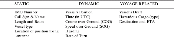
AIS information includes static, dynamic, and voyage related elements. Static information is programmed into the unit at commissioning. Dynamic information is derived from interfaces with the ship's GPS and other sensors. Voyage-related data is entered manually by the master through a password-protected routine. Table 1 is adapted from IMO standards (IMO, 2002) and summarizes AIS identification information.
Table 1. AIS vessel identification information.

In Canada, Transport Canada through its National Aerial Surveillance Program (NASP) keeps a watchful eye over ships transiting Canadian waters. The NASP is the primary tool for detecting ship-source pollution in waters under Canadian jurisdiction and validating oil anomaly detected from RADARSAT imagery as part of the Integrated Satellite Tracking of Pollution (I-STOP) project (Gauthier, et al., Reference Gauthier, Weir, Ou, Arkett and DeAbreu2007). The AIS transponder receiver is one of the onboard sensors, which helps to obtain vessel identity and voyage information. The AIS target data used in this paper was collected by one of the Transport Canada airborne AIS transponders from the NASP.
2. AIRBORNE AIS TRANSPONDER RECEIVER FOR AIR SURVEILLANCE
In coastal waters, shore-side authorities may establish automated AIS stations or equip their surveillance aircrafts with AIS transponder receivers (as shown in Figure 1) to monitor the movement of vessels through the area. These stations or surveillance aircraft may simply monitor AIS transmissions from passing ships, or may actively poll vessels via the AIS channels, requesting data such as identification, destination, estimated time of arrival, type of cargo and other information. The airborne system can be more active monitoring vessels than can the passive coast stations. The onboard transponder receiver could pick up the vessel's identification information several hundred miles away from the flight path.
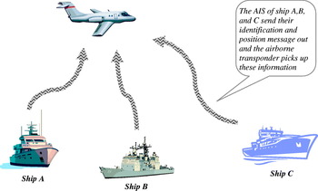
Figure 1. Airborne AIS transponder receiver.
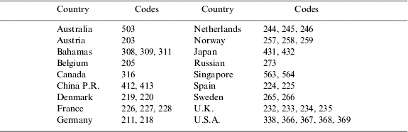
Within the vessel identification information, the MMSI (Maritime Mobile Service Identity) is a series of nine digit numbers which uniquely identify the ships and coast stations. For individual ships, the MMSI number always starts with a three digit Maritime Identification Digits (MID). The International Telecommunication Union facilitates the assignment of MIDs to countries. The first digit of MID (or the first digit of MMSI) reveals a regional structure as shown in Table 2. Each country might have one or more of unique MID numbers. Thus, the ship's origination could be identified based on the first three digits of their MMSI. Table 3 shows a sample list of countries and their MID numbers. The following link provides a complete list of MIDs for all countries (http://en.wikipedia.org/wiki/Maritime_identification_digits).
Table 2. Vessel regional code (First digit of MID or MMSI).
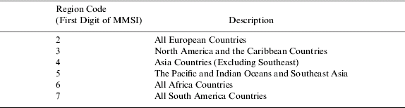
Table 3. Vessel MID code (First three digits of MMSI).
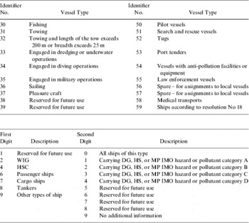
In addition, the vessel type identifier is defined as a two-digit number. It should be constructed by selecting the appropriate first and second digits. Table 4 is adapted from IMO standards (IMO, 2003), which defines the codes of vessel types.
Table 4. IMO definition of vessel type code.

DG: Dangerous Goods; HS: Harmful Substances; MP: Marine Pollutants
The MMSI and vessel type code structure provide important information for coastal nations to monitor traffic and to study shipping patterns. Section 4 will discuss how this information is used to generate various AIS reports and statistics for environmental safety, coastal security and traffic management purposes.
3. AIS VESSEL TARGET GEODATABASE
The AIS vessel target database scheme is relatively simple. It consists of a main target table with a set of attributes collected by AIS and three look-up tables (LUT) as shown in Figure 2. The AIS target database is based on ESRI ArcGIS Geodatabase technology. All vessel targets are stored as simple point features. The vessel position coordinates are stored as geographic latitude longitude under WGS-84 datum. The attribute fields data are collected by the airborne AIS transponder receiver. An importer was developed to load the data. After each surveillance flight, the AIS vessel targets collected during the mission are ingested into the geodatabase automatically as shown in Figure 3 for the data flow.
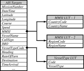
Figure 2. AIS vessel target database scheme.

Figure 3. AIS vessel target database creation and data flow.
4. GIS POWERED QUERY
AIS has potential as a useful tool for many purposes. Since September 11, 2001, littoral state monitoring (maritime domain awareness) has received greater focus. Once the data is loaded into the database, the AIS data can be overlaid with all other geographic data layers, such as a coast basemap, shipping lanes and exclusive economic zone boundary, etc. Figure 4 shows the AIS data collected from a flight on 30th January 2008 displayed with a coast basemap, shipping lanes and the Canadian federal limit (200 nautical mile boundary).

Figure 4. AIS data overlaid with other GIS data.
The AIS data could also be used for a variety of purposes, such as legal evidence and accident investigation; sharing of data between VTS' and national administrations; gathering information on the presence and pattern of traffic; planning of aids to navigation; fleet management; risk analysis and generating statistics; Search and Rescue. There are three basic groups of statistics that could be derived from the AIS target database.
1. Ship static information
2. Voyage related data
3. Dynamic positioning data
All statistics could be generated by querying the database using either a single attribute or a combination of multiple attributes. This paper gives a set of examples for demonstration purpose. The users could build their queries with a combination of any attributes and filter the data in a way to reveal the information they require. The main advantage of using a GIS system for queries is that users achieve a great visual presentation of their query results – a map. The GIS system also provides a spatio-temporal query interface for interactive query by drawing the Area-Of-Interest (AOI) directly on the map. The query results for the vessel targets are automatically displayed as a layer and could be labelled by any attribute or a combination of attributes.
4.1. MMSI Based Query
As the MMSI uniquely identifies a ship, by querying the MMSI in different ways, it could:
• reveal the ship's country of registration – using the first three digits of MMSI and the Country Look-Up Table
• reveal the information about which regions the ships come from – using the first digit of MMSI and the Region LUT (see Table 3).
Figure 5 shows a query result by setting the first digit of MMSI=2 and the date between 1st~31st January 2008.
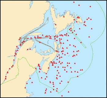
Figure 5. Ships from European countries for the month of January 2008.
4.2. Voyage Related Query
The voyage related information is manually entered by the master who has the responsibility to ensure that the information entered is valid and accurate.
• Destination.
• ETA (Estimated Time of Arrival).
• Categories (A, B, C or D) of dangerous goods, harmful substances or marine pollutants – using IMO defined vessel type LUT.
Figure 6 shows one of the query results. In this query, Halifax is the destination; the vessel type code is either 71 or 81 (i.e., the cargo ships or tankers carrying category A goods); and the date is the month of January 2008. The date and time fields were used to label the ships on the map.

Figure 6. Tanker and cargo vessels carrying Category A dangerous goods to Halifax in January 2008.
4.3. Vessel Type Based Query
Users can choose any vessel type code defined in Table 4 to query the database. Below is a sample list of possible queries.
• Where are the fishing ships (illegal fishing?) – (vessel type=30);
• Where are the search & rescue vessels – (vessel type=51);
• Where are the towing vessels – (vessel type=31);
• Where are the passenger ships – (vessel type starts with 6);
• Where are the cargo ships – (vessel type starts with 7);
• Where are the tankers – (vessel type starts with 8);
• Any combination of vessel types defined in IMO vessel type LUT.
Figure 7 shows query results with vessel type=51. It reveals the location of the search and rescue ships on 31st January 2008. The vessel's names were used to label the ships in this example. If the port has adopted critical assets tracking or monitoring systems that links to the database, the port authority could dispatch the closest tugs, repair barges or mobile cranes for fast search and rescue.

Figure 7. Location of search and rescue ships on 31st January 2008.
4.4. Location Based Tracking
To address the security challenges of seaports, AIS is a cornerstone to establish marine domain awareness and gives the ability to know what's happening in the maritime environment and to identify activities and potential factors that could influence threats to national security. To track a particular vessel's activities, query the database with its MMSI or CallSign and specify a period of time. The query results will reveal all the vessel's activities on the map for the specified period. As an example, Figure 8 maps a Norwegian ship's activities for the months of December 2007 and January 2008. The ship's position is labelled with the date and time.

Figure 8. Shipping activities of a Norwegian ship during the months of December 2007 and January 2008.
To see which vessels were in an area of interest at a specified time, specify the Area Of Interest (AOI) by drawing geo-fencing (such as a sensitive area) on the map and specify a period of time, then query the database to access all information on vessels, which were in that area during that specified time, as shown in Figure 9. The ships are labelled with their MMSI.
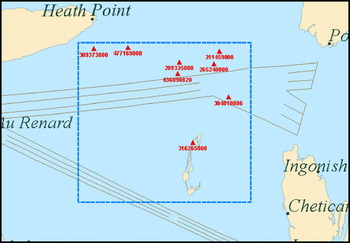
Figure 9. All ships in the specified AOI on 16th January 2008.
4.5. Statistics
Other statistics can be generated by filtering the parameters. The list below is just a few examples. It should be possible to identify the general navigation patterns and enable a division of patterns by categories from this database.
• Number of ships of a specific type
• Number of ships with a specific cargo type
• Number of ships with a specific SOG (Speed Over Ground)
• Number of ships with a specific COG (Course Over Ground)
• Number of ships with a specific MMSI
• Number of ships from a specific country (first 3 digits of MMSI)
• Number of ships from a specific region (first digit of MMSI)
• Number of ships with a specific destination
5. CONCLUSION
As discussed in this paper, AIS data can be used for a variety of purposes, such as legal evidence and accident investigation; sharing of data between VTS' and with national administrations; gathering information on the presence and pattern of traffic; planning of aids to navigation; fleet management; risk analysis and generating statistics. When the AIS data is powered with GIS technology, all the information and analysis could be presented on a map and overlaid with other geographic datasets. The potential benefits from AIS are far beyond its original designated use as a navigational aid and it will be a major element of an intelligent waterways system that takes advantage of the information provided by this technology.
Even though there are many potential uses for AIS-derived information, the main limitations for AIS might be that the data received is only as good as the data sent by the AIS. To ensure that correct AIS information is broadcast to other vessels and shore authorities, mariners are reminded to enter current voyage related data such as draught, type of hazardous cargo, destination and ETA properly at the beginning of each voyage and whenever changes occur. Although it is possible to generate and transmit false or misleading messages, mariners are cautioned that there may be severe penalties imposed by national administrations for these actions, in accordance with national legislation. They are reminded to periodically check that correct information is being broadcast by their own vessel, particularly position, heading provided by the ships master gyro and speed.
ACKNOWLEDGMENTS
We thank Canada's National Aerial Surveillance Program (NASP) and Marine Aerial Reconnaissance Team (MART) for providing the AIS data. This paper is based on an initial presentation made to the NASP/MART on effective uses of the AIS data for maritime safety and security.